WATER ... ANALYSISOFAVAILABLEPESTICIDEDATA,1972-90 U.S.GEOLOGICALSURVEY...
89
WATER-QUALITY ASSESSMENT OF THE POTOMAC RIVER BASIN: ANALYSIS OF AVAILABLE PESTICIDE DATA, 1972-90 U.S. GEOLOGICAL SURVEY Water-Resources Investigations Report 97-4051 National Water-Quality Assessment (NAWQA) Program PENNSYLVANIA D.C. WEST VIRGINIA VIRGINIA POTOMAC RIVER BASIN MARYLAND
Transcript of WATER ... ANALYSISOFAVAILABLEPESTICIDEDATA,1972-90 U.S.GEOLOGICALSURVEY...

WATER-QUALITY ASSESSMENT OF THE POTOMAC RIVER BASIN:ANALYSIS OF AVAILABLE PESTICIDE DATA, 1972-90
U.S. GEOLOGICAL SURVEYWater-Resources Investigations Report 97-4051
National Water-Quality Assessment (NAWQA) Program
PENNSYLVANIA
D.C.WEST
VIRGINIA
VIRGINIA
POTOMAC RIVERBASIN
MARYLAND

Cover. Map showing the National Water-Quality Assessment (NAWQA) Program study unitsthroughout the United States.

WATER-QUALITY ASSESSMENT OF THE POTOMAC RIVER BASIN:ANALYSIS OF AVAILABLE PESTICIDE DATA, 1972-90
U.S. GEOLOGICAL SURVEY
By Humbert Zappia and Gary T. Fisher
Water-Resources Investigations Report 97-4051
Prepared as part of the
Baltimore, Maryland1997
National Water-Quality Assessment (NAWQA) Program

U.S. DEPARTMENT OF THE INTERIORBRUCE BABBIT, Secretary
U.S. GEOLOGICAL SURVEYGordon P. Easton, Director
For additional information write to: Copies of this report can be purchased from:
District Chief U.S. Geological SurveyU.S. Geological Survey Branch of Information Services8987 Yellow Brick Road Box 25286Baltimore, MD 21237 Denver, CO 80225-0286

CONTENTS
Abstract............................................................................................................................................... 1Introduction......................................................................................................................................... 2
Purpose and scope.................................................................................................................. 2Description of the Potomac River Basin ............................................................................... 3Acknowledgments ................................................................................................................. 5
Analysis of available pesticide data in the Potomac River Basin....................................................... 5Pesticide use in the Potomac River Basin.............................................................................. 7Availability of pesticide data ................................................................................................. 9
Surface water and bottom material ........................................................................... 9Ground water ............................................................................................................ 9Biological tissue ....................................................................................................... 13
Occurrence and distribution of selected pesticides................................................................ 16Surface water and bottom material ........................................................................... 19Ground water ............................................................................................................ 34Fish tissue ................................................................................................................. 42
Whole fish ................................................................................................... 42Fish fillets .................................................................................................... 53
Evaluation of existing pesticide data coverage...................................................................... 65Surface water and bottom material ........................................................................... 65Ground water ............................................................................................................ 69Fish tissue ................................................................................................................. 70Multimedia data evaluation ...................................................................................... 71
Summary and conclusions .................................................................................................................. 72References........................................................................................................................................... 75Appendix............................................................................................................................................. 79
A. Selected standards and criteria for pesticides in water, bottom material, and fish tissue ...................................................................................... 80
FIGURES
1. Map showing location of major rivers, and physiographic divisions in the Potomac River Basin..................................................................... 4
2. Map showing general land use/land cover in the Potomac River Basin ....................................................................................................................... 6
3.-19. Maps showing locations of: 3. Sampling sites for pesticides in surface water, bottom material, or both, in the
Potomac River Basin................................................................................................. 10 4. Counties in the Potomac River Basin ....................................................................... 11 5. Sampling sites for pesticides in wells and springs in the Potomac River
Basin...........................................................................................................................12 6. Sampling sites for pesticides in fish tissue in the Potomac River Basin....................15 7. Sampling sites where dieldrin was analyzed
and reported in bottom material in the Potomac River Basin................................. 35
Contents iii

FIGURES--Continued
8. Sampling sites where chlordane and related compounds were analyzed and reported in bottom material in the Potomac River Basin .............................................................................................. 36
9. Sampling sites where DDD, DDE, or DDT were analyzed and reported in bottom material in the Potomac River Basin ................. 37
10. Sampling sites where chlordane was analyzed and reported in whole-fish tissue in the Potomac River Basin................................ 52
11. Sampling sites where DDT was analyzed and reported in whole-fish tissue in the Potomac River Basin............................... 54
12. Sampling sites where dieldrin was analyzed and reported in whole-fish tissue in the Potomac River Basin............................... 55
13. Sampling sites where BHC was analyzed and reported in whole-fish tissue in the Potomac River Basin............................... 56
14. Sampling sites where heptachlor was analyzed and reported in whole-fish tissue in the Potomac River Basin............................... 57
15. Sampling sites where chlordane was analyzed and reported in fish-fillet tissue in the Potomac River Basin................................. 63
16. Sampling sites where DDT was analyzed and reported in fish-fillet tissue in the Potomac River Basin........................................ 64
17. Sampling sites where dieldrin was analyzed and reported in fish-fillet tissue in the Potomac River Basin................................. 66
18. Sampling sites where BHC was analyzed and reported in fish-fillet tissue in the Potomac River Basin........................................ 67
19. Sampling sites where heptachlor was analyzed and reported in fish-fillet tissue in the Potomac River Basin................................. 68
TABLES
1. Major pesticides used in the Potomac River Basin, 1982-1987............................................. 8 2. Inventory of sites sampled for pesticides in surface water or bottom material,
Potomac River Basin ........................................................................................................... 9 3. Source agencies, numbers, and types of fish-tissue samples collected for analysis for
pesticides, Potomac River Basin ........................................................................................14 4. Reporting limits of selected pesticides in whole-fish tissue samples, Potomac
River Basin, 1972 to 1990 ...................................................................................................17 5. Reporting limits of selected pesticides in fish-fillet tissue samples, Potomac
River Basin, 1972 to 1990 ...................................................................................................18 6. Summary of analyses for selected pesticides in surface-water samples
collected by the U.S. Geological Survey, Potomac River Basin.........................................20 7. Concentrations of pesticides equal to or greater than reporting limits in surface-
water samples collected by the U.S. Geological Survey, Potomac River Basin, 1972 to 1990 .............................................................................................................21
8. Summary of analyses for selected pesticides in surface-water samples collected by agencies other than the U.S. Geological Survey, Potomac River Basin ..........................................................................................................................23
iv Water-Quality Assessment of the Potomac River Basin: Analysis of Available Pesticide Data, 1972–90

TABLES--Continued
9. Concentrations of pesticides equal to or greater than reporting limits in surface- water samples collected by agencies other than the U.S. Geological Survey, Potomac River Basin, 1972 to 1990 ...................................................................................24
10. Summary of analyses for selected pesticides in bottom-material samples collected by the U.S. Geological Survey, Potomac River Basin.........................................25
11. Concentrations of pesticides equal to or greater than reporting limits in bottom- material samples collected by the U.S. Geological Survey, Potomac River Basin, 1972 to 1990 ..................................................................................................26
12. Summary of analyses for selected pesticides in bottom-material samples collected by agencies other than the U.S. Geological Survey, Potomac River Basin ..........................................................................................................................30
13. Concentrations of pesticides equal to or greater than reporting limits in bottom- material samples collected by agencies other than the U.S. Geological Survey, Potomac River Basin, 1972 to 1990......................................................................31
14. Summary of analyses for selected pesticides in ground-water samples collected by the U.S. Geological Survey, Potomac River Basin.........................................38
15. Concentrations of pesticides equal to or greater than reporting limits in ground-water samples collected by the U.S. Geological Survey, Potomac River Basin, 1972 to 1990 ........................................................................................................................40
16. Summary of analyses for selected pesticides in whole-fish tissue samples, Potomac River Basin ..........................................................................................................43
17. Concentrations of pesticides equal to or greater than reporting limits in whole-fish tissue samples, Potomac River Basin, 1972 to 1990 ..........................................................44
18. Summary of analyses for selected pesticides in fish-fillet tissue samples, Potomac River Basin ..........................................................................................................58
19. Concentrations of pesticides equal to or greater than reporting limits in fish-fillet tissue samples, Potomac River Basin, 1972 to 1990 ..........................................................59
Contents v

CONVERSION FACTORS
Multiply By To obtain
Lengthinch (in.) 25.4 millimeter inches per year (in/yr) 25.4 millimeters per yearfoot (ft) 0.3048 metermile (mi) 1.609 kilometer
Areaacre 4,047 square meteracre 0.4047 hectare square mile (mi2) 259.0 hectaresquare mile (mi2) 2.590 square kilometer
Temperaturedegree Fahrenheit (oF) oC = 5/9 x (oF-32) degree Celsius (oC)
Chemical concentration in water is given in micrograms per liter (µg/L). Micrograms per liter is a unit expressing the concentration of chemical constituents in solution as weight (micrograms) of solute per unit volume (liter) of water. For concentrations less than 7,000,000 µg/L, the numerical value is the same as for concentrations in parts per billion.
Chemical concentration in bottom material is given in micrograms per kilogram (µg/kg).
Chemical concentration in biological tissue is given in milligrams per kilogram (mg/kg).
vi Water-Quality Assessment of the Potomac River Basin: Analysis of Available Pesticide Data, 1972–90

-
al
s-
t-
, m
o
-
t-
n, -
o
,
Water-Quality Assessment of the Potomac River Basin:Analysis Of Available Pesticide Data, 1972-1990
By Humbert Zappia and Gary T. Fisher
ABSTRACT
A study of available data for the period from 1972 to 1990 was conducted to characterize the occurrence and distribution of pesticides in sur-face water, bottom material, ground water, and fish tissue in the Potomac River Basin. The study was conducted by the Potomac River study unit of the U.S. Geological Survey’s National Water-Quality Assessment (NAWQA) program. Exist-ing data coverage was evaluated to guide future data-collection activities. Data from computer data bases and from published and unpublished reports were obtained from local, State, and Fed-eral agencies in the four Potomac River Basin states and the District of Columbia. Data are available for all environmental media, but geo-graphic and temporal coverage are limited. Clusters of data occur in the north-central parts of the basin, with numerous samples at discrete loca-tions in the Shenandoah and Monocacy River Basins, along the mainstem Potomac River, in the Washington, D.C., area, and in streams along the Potomac Estuary. Much of the available surface-water and bottom-material data are from the ear-lier years of the period of interest, the ground-water data are from the middle years, and the fish-tissue data are distributed over much of the period. Overall, temporal coverage is not sufficient for analysis of trends. Comparisons between different sample media are possible in some areas of the Potomac River Basin, particularly in the northern end of the Great Valley.
Residual concentrations of some pesticides have been found in surface water, bottom mate-rial, ground water, and fish tissue. Samples have
been analyzed for a total of at least 69 pesticidesand related compounds in surface water, bottommaterial, ground water, and fish tissue. Most concentrations of the pesticides analyzed during theperiod from 1972 to 1990 were less than or equto reporting limits.
For surface-water samples, 13 out of 41 peticides and related compounds analyzed had concentrations equal to or greater than the reporing limits. Compounds reported in surface waterincluded 2,4-D, atrazine, aldrin, chlordane, DDT and related compounds, dieldrin, endrin, lindaneprometone, prometryne, and simazine. For bottomaterial samples, 19 of 31 pesticides and relatedcompounds analyzed had concentrations equal tor greater than the reporting limits. Compounds reported in bottom material included aldrin, chlordane, DDT and related compounds, diazinon, dieldrin, endosulfan, endrin, ethion, heptachlor, heptachlor epoxide, lindane, parathion, and tox-aphene. In ground-water samples, 14 of 39 pesticides and related compounds analyzed hadconcentrations equal to or greater than the reporing limits. Compounds reported in ground water included 2,4-D, atrazine, chlordane, cyanazine, DDT and related compounds, diazinon, dieldrin, endosulfan, endrin, heptachlor epoxide, malathiomethyl parathion, simazine. For fish- tissue samples, 30 of the 37 pesticides and related compounds analyzed had concentrations equal tor greater than the reporting limits. Compounds reported included aldrin, chlorpyrifos, dacthal, dieldrin, endrin, HCB, heptachlor, heptachlor epoxide, methoxychlor, mirex, PCA, toxaphene, and those compounds related to chlordane, DDTand lindane.
Analysis of Available Pesticide Data, 1972-1990 1

INTRODUCTION
The U.S. Geological Survey’s (USGS) National Water-Quality Assessment (NAWQA) program began in 1986 with seven pilot studies to test and refine concepts for the design and con-duct of the program (Hirsch and others, 1988). Using lessons learned during the pilot studies, and supported by recommendations by the National Academy of Science (1990), the NAWQA pro-gram began full-scale implementation in fiscal year 1991 (Leahy and others, 1990).
The goals of the NAWQA program are to:
1) Provide a nationally consistent descrip- tion of current water-quality conditions for a large part of the Nation’s water resources;
2) Define long-term trends (or lack of trends) in water quality;
3) Identify, describe, and explain, to the extent possible, the major natural and human factors that affect observed water-quality conditions and trends.
It is anticipated that the data and findings of the NAWQA program will provide a scientific basis for major national decisions that affect water-quality policy and regulation. It is impor-tant that such decisions be based on a sound understanding of the factors that affect water qual-ity and that they be based on nationally consistent data and approaches. The NAWQA program is designed to provide these requirements for informed decision-making on a national level.
The NAWQA program consists of two major components--national synthesis and study units (Leahy and Wilber, 1991). The national-syn-thesis component will address specific water-quality issues that are of common concern in most parts of the Nation. It is designed to address these issues through comparative studies among differ-ent hydrologic settings in the Nation, using data that are collected and analyzed in a consistent manner. The data needed for national-synthesis
topics will be provided, in large part, by the other major component of the NAWQA program--study units.
Fifty-nine study units covering areas of 1,200 to more than 65,000 mi2 have been selected to include major river basins and aquifer systems. Collectively, the study units incorporate about 60 to 70 percent of the Nation’s water use and popula-tion served by public water supplies. Activity in each study unit is designed to be continual, with alternating periods of intensive investigation and low-level monitoring. Each study unit will address physical, chemical, and biological charac-teristics of surface-water and ground-water quality. Starting in 1991, groups of 15 to 20 study units were begun at intervals of 3 years.
The Potomac River Basin study unit of the NAWQA program began in fiscal year 1991 (Ger-hart, 1991). It was selected to be in the first group of 20 study units because of its national promi-nence, its high population (mostly in the Washington, D.C., area), and its significance to the health of the Chesapeake Bay. The first intensive phase of the Potomac River Basin study unit is scheduled for completion in fiscal year 1997, at which time the study unit will enter its first low-level monitoring phase. In fiscal year 2002, the second intensive phase of the Potomac River Basin study unit is scheduled to begin.
Purpose and Scope
The purpose of this report is to provide a ret-rospective analysis of pesticide data for selected environmental media in the Potomac River Basin, as part of NAWQA’s objective to describe water-quality status and trends. Available data are ana-lyzed to characterize the occurrence and distribution of pesticides. The available pesticide concentration data are evaluated for their potential to identify problem areas, document differences among basin subunits, describe trends, compare to national standards, and determine areas where sampling for the various selected environmental media overlap. In addition, an evaluation is made of existing pesticide data coverage to guide future
2 Water-Quality Assessment of the Potomac River Basin

data-collection efforts. The report and its analysis contribute to one of the first two National Synthe-sis topics of NAWQA and it documents current information as a starting point for future NAWQA work in the Potomac River Basin study unit.
This report addresses available data for pes-ticides in surface water, bottom material, ground water, and biological tissue. Data considered are limited to those collected after 1971 to reduce problems associated with changes in laboratory methods and to maximize usage of data-collection networks and computer data bases that became common about 1972.
Description of the Potomac River Basin
The Potomac River Basin (fig. 1) includes 14,670 mi2 in the States of Virginia (5,723 mi2), Maryland (3,818 mi2), West Virginia (3,490 mi2), and Pennsylvania (1,570 mi2), and in the District of Columbia (69 mi2). It has a complex environ-mental setting consisting of various combinations of natural and human factors that affect water quality. The basin contains parts of seven physio-graphic provinces and subprovinces underlain by a wide variety of rock types. Land use in 1990 was about one-half forested, one-third agricultural, and less than one-tenth urban. About two-thirds of the 4.67 million people who lived in the basin in 1990 resided in the Washington, D.C., area. About 97 percent of the water used in the basin in 1990 was from surface-water sources.
The average-annual temperature in the Poto-mac River Basin ranges from about 47oF in the mountainous western part of the basin to just less than 58oF in Washington, D.C. (U.S. Department of Commerce, 1991a,b,c,d). Temperatures are typically lower in the western part of the basin. In the rest of the basin, average-annual temperature ranges from about 51oF to 55oF, with no apparent areal pattern. Temperature varies considerably throughout the year. July tends to be the hottest month and January the coldest. The difference between the average monthly temperatures in July
and January is about 45oF, regardless of location in the basin.
The average-annual precipitation in the basin ranges from about 32 in. in the South Branch Potomac River drainage to about 47 in. near the source of the Potomac River in the North Branch Potomac River drainage (U.S. Department of Commerce, 1991a,b,c,d). In general, precipitation in the area of the South Branch Potomac and Shenandoah Rivers averages less than 40 in/yr and precipitation in the rest of the Potomac River Basin averages more than 40 in/yr. The high west-ern mountains of Maryland and West Virginia have the greatest areal variability in average-annual precipitation, with amounts ranging from about 37 to 47 in.
Parts of seven physiographic provinces or subprovinces lie within the Potomac River Basin: the Appalachian Plateau, Valley and Ridge and its Great Valley subprovince, Blue Ridge, Piedmont and its Triassic Lowlands subprovince, and Coastal Plain (fig. 1). The rocks in the mountain-ous Appalachian Plateau, and Valley and Ridge provinces are sedimentary (sandstones, shales, and limestones). The mountainous Blue Ridge and rolling Piedmont Provinces are underlain mostly by crystalline rocks. The bedrock in all four of these provinces is blanketed by a mantle of weath-ered rock material, or regolith, which in some places is more than 100 ft thick. The Coastal Plain Province is underlain by relatively younger, unconsolidated sediments (sand, silt, and clay) in layers that dip to the southeast.
Although the geology of the Potomac River Basin is very complex, the geologic units can be broadly categorized into four groups: unconsoli-dated sediments, carbonate sedimentary rocks, siliciclastic sedimentary rocks, and crystalline rocks. Unconsolidated sediments underlie about 15 percent of the basin, carbonate sedimentary rocks underlie about 17 percent, siliciclastic sedi-mentary rocks underlie about 42 percent, and crystalline rocks underlie about 19 percent of the basin. The remaining 7 percent consists of geo-logic units that contain significant portions of both carbonate and siliciclastic sedimentary rocks.The Potomac River Basin includes four major tributar-
Analysis of Available Pesticide Data, 1972-1990 3

Figure 1. Location of major rivers and physiographic divisions in the Potomac River Basin.
40O
39O
38O
79O
78O
77O
BASE FROM U.S. GEOLOGICAL SURVEYDIGITAL DATA, 1:2,000,000, 1972.
10 20 30 MILES
10 20 30 KILOMETERS0
0
HARRISONBURG
MOOREFIELD
WINCHESTER
MARTINSBURG
GETTYSBURG
WAYNESBORO
FREDERICK
CUMBERLAND HAGERSTOWN
ALEXANDRIA
ROCKVILLELEESBURG
FRONT ROYAL
HARPERSFERRY
CHAMBERSBURG
STAUNTON
STRASBURG
WAYNESBORO
W A SHINGTO N , D .C.
MANASSAS
PETERSBURG
POTOMAC RIVERBASIN BOUNDARY
Location of study area
D .C.
V IRG INIA
W ESTV IRG INIA
PENNSYLV ANIA
POTOMAC RIVERBASIN
MARYLAND
APPALACH IANPLATEAU
VALLEYAND
RID G E
G REATVALLEY
TRIASSICLOW LANDS
TRIASSICLOW LANDS
PIEDMONT
PIEDMONT
BLUE RIDG E
BLUE RID G E
VALLEYAND
RID G E
COASTAL PLAIN
Ph y siograp h icprovinceboundaries
4 Water-Quality Assessment of the Potomac River Basin

ies, the North and South Branches Potomac River, the Shenandoah River, and the Monocacy River. Other large tributaries include the Cacapon River, Conococheague Creek, and the Occoquan River. Smaller tributaries that are important for potential water-quality impacts include several tributaries to the Shenandoah River, Antietam Creek, and the Anacostia River. All of these tributaries except for the Occoquan and Anacostia Rivers are located entirely above the Fall Line, which is an irregular boundary between the Piedmont and Coastal Plain Physiographic Provinces.
Total natural runoff in most of the basin (those parts not affected by reservoirs or drainage from coal mines) ranges from about 9 to 22 in/yr (U.S. Geological Survey, 1991a,b,c,d). Runoff from less than 3 percent of the drainage area is regulated, the most significant dams being on the North Branch Potomac River and the Occoquan River. The contribution of ground-water inflow to total runoff ranges from 39 to 61 percent, and averages 52 percent, for those parts of the basin upstream from Washington, D.C. (Trainer and Watkins, 1975). Total runoff and the percentage of ground-water contribution generally are largest for areas underlain by limestone.
Ground water occurs primarily in secondary openings (joints, faults, and other fractures) in the sedimentary and crystalline rocks of the western and central parts of the basin, and in the pore spaces in the overlying regolith mantle. Ground water occurs in pore spaces in the unconsolidated sediments of the Coastal Plain Province. Of all the ground-water-producing units in the basin, the limestone units of the Valley and Ridge Province, parts of the regolith, and the sands of the Coastal Plain Province produce the most ground water.
In the mid-1970’s, 51 percent of the land in the Potomac River Basin was in forest, 36 percent was used for agricultural activities, and 8 percent was urban (U.S. Geological Survey, 1979a,b,c,d, and 1980a,b,c,d) (fig. 2). By 1985, 52 percent of the land in the basin was forested, 32 percent was used for agricultural activities, and 12 percent was urban (Camacho, 1989).
Acknowledgments
The authors are grateful to a number of per-sons who assisted in the compilation of data for this report. Judith Wheeler of USGS did an initial pesticide-data inventory that was very helpful in determining sources of available data. The follow-ing persons provided data on pesticides in fish tissue in their respective jurisdictions: Hamid Karimi, District of Columbia Department of Con-sumer and Regulatory Affairs; Deirdre Murphy, Maryland Department of the Environment; Robert Frey and Tammy Schreffler, Pennsylvania Depart-ment of Environmental Protection; James Cummins, Interstate Commission on the Potomac River Basin; Jean Gregory, Virginia Department of Environmental Quality; Janice Smithson, West Virginia Department of Natural Resources; Rob-ert Foley, U.S. Fish and Wildlife Service; and Charles Kanetsky, U.S. Environmental Protection Agency.
ANALYSIS OF AVAILABLE PESTICIDE DATA IN THE POTOMAC RIVER BASIN
Pesticide data are available from three gen-eral sources. The preferred source for our purposes is computer data bases, where data can be easily retrieved, manipulated, and analyzed. These data bases, such as the U.S. Environmental Protection Agency’s STOrage and RETrieval Sys-tem (STORET) and the U.S. Geological Survey’s National Water Inventory System (NWIS) are most desirable because they are easy to use. Another source of data is published reports. Some reports may present analysis and interpretation of the data, but not the basic data. Reports are less desirable as a data source than computer data bases, because data must be entered into a data base or word processor for analysis and presenta-tion. The final source of data is unpublished records. These data may exist in local computer systems, but often are in paper files. In either case, these data are least desirable because they are difficult to locate and considerable effort is required to compile the data and to perform qual-ity-assurance analysis.
Analysis of Available Pesticide Data, 1972-1990 5

HARRISONBURG
MOOREFIELD
PETERSBURG
WINCHESTER
MARTINSBURG
HARPERSFERRY
GETTYSBURG
WAYNESBORO
HAGERSTOWN
FREDERICK
CUMBERLAND
MANASSAS
LEESBURGROCKVILLE
ALEXANDRIAW A S H INGTO N , D .C.
FRONT ROYAL
CHAMBERSBURG
STAUNTON
STRASBURG
WAYNESBORO
79O
40O
39O
38O
78O
77O
LAND USE FROM U.S. GEOLOGICAL SURVEY,(1979a,b,c,d; 1980a,b,c,d)
EXPLANATION
PENNSYLVANIAMARYLAND
Figure 2. General land use/land cover in the Potomac River Basin.
FOREST
AGRICULTURAL
URBAN
WATER
10 20 30 MILES
10 20 30 KILOMETERS0
0
6 Water-Quality Assessment of the Potomac River Basin

e
c
e
he
r-
d at
u-
s e
Data on pesticides in surface water, bottom material, and ground water were obtained from both the STORET and NWIS data bases. Suffi-cient data for these three environmental media were available from these sources to meet the objectives of this report. Some additional data were available from local agency reports or from USGS published reports that were prepared in cooperation with local jurisdictions, but no sus-tained attempts were made to search other literature. Unpublished data sources for surface water, bottom material, and ground water were not considered for this report.
Some data on pesticides in biological tissue were available from STORET, but not from NWIS. These data were obtained as unpublished records or published reports directly from State and Federal agencies.
Generally, little information is obtainable on quality-assurance programs used in the collection of data used in this report. Most agencies have internal documentation on protocols and quality control for both field and laboratory procedures. It is assumed that data used in this report have been collected using generally accepted practices. Detailed evaluations of quality-assurance pro-grams are beyond the purpose and scope of this report.
Because field and laboratory methods differ widely even within the scope of accepted prac-tices or within agencies, no specific information is presented on detection limits, analytical accuracy, and precision. Data are presented only on total numbers of analyses made and on those which were equal to or greater than reporting limits for the particular analyses done.
Presentations of data in this report are gener-ally qualitative and focus on the number of samples collected and the occurrence and distribu-tion of pesticides in the basin greater than laboratory reporting limits. Information on report-ing limits, although not explicitly available in many cases, was gleaned from "remarks" data fields with indicators such as "greater than (>)" or "not detected (ND)". Traditional approaches to presenting and analyzing data, such as boxplots,
temporal plots, descriptive statistics, and compari-sons to standards and criteria were not used in this report because of the paucity of data and inade-quate information on quality assurance of the data. A table listing selected standards and criteria for water and fish tissue is included for the reader’s convenience in appendix A.
Pesticide Use in the Potomac River Basin
A review of pesticide use in the ChesapeakBay Basin (Roeser, 1988) and a national inven-tory (Gianessi and Puffer, 1988 and 1990), alongwith local knowledge and a review of pesticide sampling data, indicate that more than 100 pesti-cides are being or have been used in the PotomaRiver Basin. These include herbicides, insecti-cides, and fungicides. It is difficult to compile a comprehensive list of pesticides or to quantify usof specific compounds because they are distrib-uted under multiple trade names in various formulations and are used in a variety of agricul-tural, domestic, and industrial applications.
The greatest usage of pesticides is for agri-cultural operations. Forty-seven pesticides are known to have been used on more than 10,000 acres each in the period 1982-1987 (table 1). Some of these pesticides have been restricted orbanned since 1982. Large-scale applications in tPotomac River Basin include crop production, orchards, and confined poultry operations. Impotant herbicides include alachlor, atrazine, simazine, and metolachlor for corn and alfalfa, an2,4-D for corn, small grains, and pasture. Paraquis widely used in Virginia for minimum-tillage corn production. Turf is an important crop in Maryland and 2,4-D is used extensively. Carbofran is the most used insecticide for crop production. Less widespread but important cropinclude apples and tobacco, for which farmers uscertain specialty pesticides for weed, insect, andfungus control. Simazine is an important herbi-cide used in apple orchards.
Analysis of Available Pesticide Data, 1972-1990 7

8 Water-Quality Assessment of the Potomac River Basin
Table 1. Major pesticides used in the Potomac River Basin, 1982-1987
[Use sources: Roeser (1988), Gianessi and Puffer (1988, 1990). All usage data are for the period 1982-1987.> is greater than or equal to; < is less than. Pesticides in bold were reported used on more than 10,000 acres].
Pesticide
>1,000 acres treated
<1,000 acrestreated
Some use reported Pesticide
>1,000 acres
treated
<1,000 acres
treated
Some use reported
2,4-D x Flucythrinate x2,4-DB x Fluometuron x2,4,5-T x Fluvalinate xAcifluorfen x Fomesafen xAlachlor x Fonofos xAldicarb x Furadan xAmetryne x Glyphosate xAtrazine x Heptachlor xAzinphos-methyl x Imaziquin xBaygon x Imidan xBenfluralin x Lactofen xBenomyl x Lannate xBensulide x Linuron xBentazon x Maeichydrazide xBiphenthrin x Malathion xBromoxynil x Mancozeb xButylate x Maneb xCaptan x MCPA xCarbaryl x Mecoprop (MCCP) xCarbofuran x Methamidothos xCarboxin x Methomyl xChloramben x Methoxychlor xChlorothalonil x Metiram xChlorpropham x Metolachlor xClomazone x Metribuzin xCyanazine x Napropamide xCycloate x Naptalam xCypermethrin x Norflurazon xDalapon x Orthine xDCPA x Oryzalin xDiazinon x Oxamyl xDicamba x Oxyfluorfen xDichlobenil x Paraquat xDiclofop Methyl x Parathion xDieldrin x Pendimethalin xDiethyl-Ethyl, x Permethrin xDinoseb x Phosmet xDiphenamid x Phosphamidon xDisulfoton x Picloram xDiuron x Profluralin xEPTC x Silvex xEthalfluralin x Simazine xEthyl Chlorimuron x Thiameturon xFenamiphos x Tralomethrin xFenarimol x Triclopyr xFenvalerate x Trifluralin xFluazifop x Vernolate x

Use of pesticides in urban and developed areas is also substantial. The herbicides 2,4-D and dicamba and the insecticides carbaryl and diazi-non are widely used for lawn and garden care. Glyphosate is a non-selective herbicide that is widely used in agricultural and urban settings for general weed control along roads and around buildings.
A number of insecticides have been banned or their use discontinued, but they were used at one time in the Potomac River Basin. These include aldrin, BHC, chlordane, DDT, dieldrin, endrin, and heptachlor. They are important because they all have been linked to toxic effects and because they are persistent in the environment (Smith and others, 1988, p. 27).
Availability of Pesticide Data
Pesticide data for surface water, bottom material, ground water and fish tissue are avail-able from State, Federal, and local agencies in the Potomac River Basin. The data were collected to address issues of national, regional, and local con-cern and are available in digital formats, published reports, and unpublished records.
Surface Water and Bottom Material
A data search of the STORET and NWIS data bases revealed that 506 samples have been
collected for pesticides in surface water at 138 sites in the Potomac River Basin by local, State, and Federal agencies. A report by Lang (1982) discusses sampling by USGS for pesticides in the mainstem Potomac River near Washington, D.C., where another 29 samples were collected over a 30-month period. There were 309 samples col-lected at 137 sites for pesticides in bottom material. These data were found through searches of the STORET and NWIS data bases and from published reports for Frederick and Washington Counties, Maryland. (Dine and others, 1985; Duigon and others, 1989). Table 2 inventories data collected by USGS and other agencies and lists the number of sites sampled that are in the data base for each state. Figure 3 shows locations of sampling sites, and figure 4 shows locations of counties in the Potomac River Basin.
Ground Water
A data search of the STORET and NWIS data bases revealed that 110 samples have been collected by USGS for pesticides in wells at 87 sites in the Potomac River Basin, with very lim-ited data available from other agencies. Other than a survey for aldrin done on 121 samples at 66 sites in Virginia east of the Shenandoah River, only a single sample for 7 pesticides in ground water was available from other agencies. Springs were sam-pled by USGS at 32 sites, where 63 samples were collected. Figure 5 shows locations of sampling sites known from STORET and NWIS.
Analysis of Available Pesticide Data, 1972-1990 9
Table 2. Inventory of sites sampled for pesticides in surface water or bottom material, Potomac River Basin
[USGS, U.S. Geological Survey]
Number of sites sampledSurface water Bottom material
State USGS Non-USGS USGS Non-USGS
District of Columbia 10 0 0 0Maryland 0 21 30 5Pennsylvania 0 2 0 2Virginia 7 104 12 87West Virginia 0 4 0 1
1 The Potomac River at Washington, D.C., site is actually located on the Virginia side of the Potomac River.

40O
39O
38O
79O
78O
77O
10 20 30 MILES
10 20 30 KILOMETERS0
0
HARRISONBURG
MOOREFIELD
WINCHESTER
MARTINSBURG
GETTYSBURG
WAYNESBORO
FREDERICK
CUMBERLANDHAGERSTOWN
ALEXANDRIA
ROCKVILLELEESBURG
FRONT ROYAL
HARPERSFERRY
CHAMBERSBURG
STAUNTON
STRASBURG
WAYNESBORO
W A SHINGTON, D.C.
MANASSAS
PETERSBURG
Figure 3. Locations of sampling sites for pesticides in surface water, bottom material, or both in the Potomac River Basin.
EXPLANATION
USGS SURFACE WATER
USGS BOTH
NON-USGS SURFACE WATER
NON-USGS BOTTOM MATERIAL
NON-USGS BOTH
USGS BOTTOM MATERIAL
10 Water-Quality Assessment of the Potomac River Basin

40O
39O
38O
79O
78O
77O
10 20 30 MILES
10 20 30 KILOMETERS0
0
HARRISONBURG
MOOREFIELD
WINCHESTER
MARTINSBURG
GETTYSBURG
FREDERICK
CUMBERLAND
HAGERSTOWN
ALEXANDRIA
ROCKVILLELEESBURG
FRONTROYAL
HARPERSFERRY
CHAMBERSBURG
STAUNTON
STRASBURG
WAYNESBORO
W A SHINGTON, D.C.
MANASSAS
PETERSBURG
Figure 4. Locations of counties in the Potomac River Basin .
WAYNESBORO
BEDFORD
GARRETT CARROLLWASHINGTON
FREDERICKMORGAN
MINERALBERKELEY
HAMPSHIRE
FREDERICKGRANT
HARDY
PRINCEGEORGES
FAIRFAX
WARREN
PENDLETON PRINCE
WILLIAM
CHARLES
HIGHLAND
STAFFORD
ST MARYS
AUGUSTA
FRANKLINFULTON
ADAMS
ALLEGANY
JEFFERSON
MONTGOMERYLOUDOUNCLARKE
SHENANDOAH
FAUQUIER
ROCKINGHAM PAGE
SOMERSET
Analysis of Available Pesticide Data, 1972-1990 11

40O
39O
38O
79O
78O
77O
10 20 30 MILES
10 20 30 KILOMETERS0
0
HARRISONBURG
MOOREFIELD
WINCHESTER
MARTINSBURG
GETTYSBURG
FREDERICK
CUMBERLANDHAGERSTOWN
ALEXANDRIA
ROCKVILLELEESBURG
FRONT ROYAL
HARPERSFERRY
CHAMBERSBURG
STAUNTON
STRASBURG
WAYNESBORO
W A SHINGTO N , D .C.
MANASSAS
PETERSBURG
WAYNESBORO
Figure 5. Locations of sampling sites for pesticides in wells and springs in the Potomac River Basin.
EXPLANATION
WELLS SAMPLED BYUSGS
WELLS AND SPRINGS SAMPLEDBY OTHER AGENCIES
SPRINGS SAMPLED BY USGS
12 Water-Quality Assessment of the Potomac River Basin

Several published reports were also avail-able that provide some additional data on pesticides in ground water. Wright (1990) dis-cussed data on pesticides in five springs and one well in Clarke County, Va. Samples were ana-lyzed for 27 pesticides, and are included in the NWIS data base and figure 5. Duigon and others (1989) presented data on samples analyzed for 11 pesticides in 6 wells and 1 spring and 15 pesti-cides in 1 spring in Washington County, Md. These data are also included in NWIS and figure 5.
Several other studies collected data on pesti-cide concentrations in ground water that are not included in the STORET or NWIS data bases. Because precise locations of sampling are not available, none of these samples are included in figure 5 or in any data tables, but results of the other studies are discussed later in this report. Kozar and others (1991) described ground-water sampling conducted in Jefferson County, W. Va., in July 1988. Analyses were made for 20 pesti-cides at 29 sites. Elmore and Weaver (1987) present the results of sampling public water-sup-ply wells in Maryland in 1983 for 14 herbicides. Two of these wells were located within the Poto-mac River Basin--one in Washington County, Md., and one on the eastern border of the basin near the southeastern corner of Frederick County, Md. Goodell and LoCastro (1989) present the results of sampling 60 wells in Clarke and Frederick Coun-ties, Va., for 11 pesticides. This sampling took place in July and August 1987. Finally, Mostaghimi and others (1989) discuss pre-Best Management Practices (BMP) sampling in a 5.84-mi2 watershed in Westmoreland County, Va., as part of a long-term (1986-1994) study of water-quality impacts of agricultural practices. Samples were collected 17 times at 8 wells during 1986 and 1987 and were analyzed for 22 pesticides.
The Pesticides in Ground Water Data Base (U.S. Environmental Protection Agency, 1992a) describes several other investigations of pesticides in ground water in the Potomac River Basin. The U.S. Department of Agriculture has conducted research on pesticides at its Beltsville Agricultural Research Center, just northeast of Washington, D.C. Virginia Polytechnic Institute and State Uni-
versity performed household water-quality surveys in Warren and Page Counties, Va. West Virginia University conducted a study in the orchard areas of Berkeley, Jefferson, and Hampshire Counties, W. Va. No data are included from these investiga-tions because they were not listed in the cited report and were not available from STORET.
Biological Tissue
No data on pesticides in tissues were avail-able from NWIS. Tissue pesticide-concentration data were available from STORET, although not all data collected were available through STORET. Published and unpublished data were obtained directly from State and Federal agencies, in tabu-lar and digital formats, for inclusion in this report.
Although several types of biological tissue from tidal and non-tidal areas have been sampled in the Potomac River Basin, this report is focused entirely on fish-tissue samples from the non-tidal areas of the Potomac River Basin. Other types of tissue, such as mollusk tissue, have been sampled at only a few sites within non-tidal areas of the Potomac River Basin, and are not included in this report.
State and Federal agencies have sampled fish tissue in the Potomac River Basin for com-pounds that can bioaccumulate, such as pesticides, because of the increased possibility of detecting them at concentrations that are too low to detect in water or bottom material, because they occur epi-sodically, eluding detection in other media (Crawford and Luoma, 1993).
Analysis for pesticides in fish tissue began in the Potomac River Basin during the mid- to late-1970’s, usually as part of "core" monitoring networks recommended by the U.S. Environmen-tal Protection Agency (USEPA) to fulfill State water-quality monitoring requirements as set forth by Section 106 (e) of the Clean Water Act (U.S. Environmental Protection Agency, 1976). In 1984, after the USEPA reevaluated the "core" monitoring programs and recommended changes in monitoring strategies, the Potomac River Basin states reevaluated their existing core monitoring
Analysis of Available Pesticide Data, 1972-1990 13

networks and subsequently discontinued some sites and initiated others (Murphy, 1988; U.S. Environmental Protection Agency, 1984; J. Gre-gory, Virginia Department of Environmental Quality, oral commun., 1993; C. Kanetsky, U.S. Environmental Protection Agency, oral commun., 1993). Potomac River Basin states continue to col-lect fish tissues as part of established water-quality monitoring networks. In addition, several special studies were conducted by Federal and State agen-cies to address issues of local or national concern.
Fish tissue has been sampled at 63 sites in the four Potomac River Basin states and the Dis-trict of Columbia (table 3). The majority of the sampling sites are located on the mainstem Poto-mac River and near Washington, D.C. (fig. 6). The remainder of the sites are located on several of the Potomac River’s major tributaries and on a few smaller streams with a history of contamination problems.
Typically, two types of fish tissue have been sampled in the Potomac River Basin: whole fish and fish fillets (table 3). Whole-fish tissues are used to address questions of pesticide occurrence, spatial characterization, trends, and bioavailability (Crawford and Luoma, 1993). Fish-fillet tissues are most often used to determine potential human health risk associated with fish consumption. A few sites have had other fish-tissue types col-lected at them, such as fish carcasses (Block and others, 1990), but are not included in this report.
The data presented in this report are mostly from Maryland, Pennsylvania, Virginia, and West Virginia State "core" monitoring networks. Also included are two Federal nationwide surveys--the U.S. Fish and Wildlife Service’s (USFWS) National Contaminant Biomonitoring Program (Schmitt and others, 1990) and USEPA’s National Study of Chemical Residues in Fish (U.S. Envi-
14 Water-Quality Assessment of the Potomac River Basin
Table 3. Source agencies, numbers, and types of fish-tissue samples collected for analysis for pesticides, Potomac River Basin
Number of Number of Number of sites with sites with sites with whole-fish fish-fillet whole-fish Number of Number ofsamples samples and fish-fillet whole-fish fish-fillet
Agency only only samples samples samples
District of Columbia 0 10 0 0 93 Department of Consumer and Regulatory Affairs
Maryland Department 7 1 15 187 69 of the Environment
Pennsylvania Department 0 4 0 0 4 of Environmental Protection
Virginia Department of 0 0 8 10 20 Environmental Quality
West Virginia Department 8 0 0 30 0 of Natural Resources
U.S. Environmental 3 0 1 4 1 Protection Agency
U.S. Fish and Wildlife 1 0 5 35 10 Service

40O
39O
38O
79O
78O
77O
10 20 30 MILES
10 20 30 KILOMETERS0
0
HARRISONBURG
MOOREFIELD
WINCHESTER
MARTINSBURG
GETTYSBURG
FREDERICK
CUMBERLAND HAGERSTOWN
ALEXANDRIA
ROCKVILLELEESBURG
FRONT ROYAL
HARPERSFERRY
CHAMBERSBURG
STAUNTON
STRASBURG
WAYNESBORO
W A SHINGTO N , D .C.
MANASSAS
PETERSBURG
Figure 6. Locations of sampling sites for pesticides in fish tissue in the Potomac River Basin.
WAYNESBORO
EXPLANATION
WHOLE FISH SAMPLED
WHOLE FISH AND FILLETSSAMPLED
FISH FILLETS SAMPLED
Analysis of Available Pesticide Data, 1972-1990 15

ronmental Protection Agency,1992b and 1992c)--and sites sampled by the District of Columbia Department of Consumer and Regulatory Affairs. Several Federal, State, and local special studies are also included (table 3).
Often, the same pesticide or its related com-pounds were reported in several different forms by the different agencies. DDE was reported in sev-eral various ways by the different agencies conducting sampling in the Potomac River Basin. For example, DDE was reported as o,p'-DDE, o,p'-DDE and p,p'-DDE, or simply as DDE. The data in this report are presented as they were reported by the investigating agency. Analyses of fish tis-sue were performed by State, local, Federal, or contract laboratories. Information on laboratory methods and quality-assurance (QA) or quality-control (QC) data in many cases is not readily available or no longer exists. Also, laboratory QA/QC and laboratory methods are complex issues, owing to the many different agencies and laboratories analyzing fish tissue, including the many changes in procedures used to analyze Poto-mac River Basin tissue samples. Considering the complexity of the laboratory QA/QC and labora-tory methods issue and the scarcity of documentation, an in-depth compilation and dis-cussion of laboratory QA/QC and methods is not presented in this report.
A total of 266 whole-fish samples were col-lected at 48 sites (table 3, fig. 6). The whole-fish samples were usually composites of three or more of a bottom feeding fish or game fish of a single species (Block and others, 1990; R. Frey, Pennsyl-vania Department of Environmental Protection, written and oral commun., 1993; J. Gregory, Vir-ginia Department of Environmental Quality, written and oral commun., 1993; Schmitt and oth-ers, 1990; J. Smithson, West Virginia Department of Natural Resources, written and oral com-mun.,1993; U.S. Environmental Protection Agency, 1992a,b; Murphy, 1988). Some single-fish, whole-fish samples were also collected.
The whole-fish samples were analyzed for 37 pesticides and related compounds (table 4). Table 4 lists reporting limits by agency for these analyses. Of the 37 compounds analyzed, 34 were organochlorine insecticides and related com-
16 Water-Quality Assessment of the Potomac River Basin
pounds. Twenty of the insecticide compounds were, or were related to BHC, chlordane, or DDT. Three other compounds--HCB, a fungicide; PCA, a fungicide related compound; and dacthal, an her-bicide--also were analyzed.
A total of 197 fish-fillet samples were col-lected at 44 sites (table 3). The fish-fillet samples were usually composites of three or more bottom or game fish of a single species, with scales removed and with skin removed or intact (Block and others, 1990; R. Frey, Pennsylvania Depart-ment of Environmental Protection, written and oral commun., 1993; J. Gregory, Virginia Department of Environmental Quality, written and oral com-mun., 1993: Murphy, 1988; Sommerfield and Cummins, 1989; U.S. Environmental Protection Agency, 1992a,b). Some single-fish fillet sam-ples were also collected.
The fish-fillet samples were analyzed for 34 pesticides and their related compounds (table 5). Table 5 lists reporting limits by agency for these analyses. Of the 34 compounds analyzed, 31 were organochlorine insecticides and related com-pounds. Twenty-one of the insecticide compounds were, or were related to, BHC, chlordane, or DDT. Three other compounds--HCB, a fungicide; PCA, a fungicide related compound; and dacthal, an her-bicide--also were analyzed.
Occurrence and Distribution of Selected Pesticides
Pesticides have been reported in surface water, bottom material, ground water, and fish tis-sues in the Potomac River Basin. Hydrophilic and hydrophobic pesticides have been reported, to include herbicides, fungicides, and insecticides. In addition, pesticides have been reported in many areas in the Potomac River Basin, although data coverage is often limited spatially.

Analysis of Available Pesticide Data, 1972-1990 17
Table 4. Reporting limits of selected pesticides in whole-fish tissue samples, Potomac River Basin, 1972 to 1990
[MD, Maryland Department of the Environment; VA, Virginia Department of Environmental Quality; WV, West Virginia Department of Natural Resources; PA, Pennsylvania Department of Environmental Protection; WDC, District of Columbia Department of Consumer and Regulatory Affairs; USFWS, U.S. Fish and Wildlife Service; USEPA,U.S. Environmental Protection Agency; All measurements are in milligrams per kilo-gram. --, no analyses performed; NA, analyses performed but value not available]
Pesticide MD VA WV PA WDC USFWS USEPA
Aldrin 0.001,0.002,0.003 0.1 0.01 -- -- -- --
α-BHC1 .002 .1 .01 -- -- 0.01 0.0025
β-BHC1 -- -- .01 -- -- -- --
δ-BHC1 -- -- .01 -- -- -- --
γ-BHC1 (lindane) .002 -- .01 -- -- -- .0025
Chlordane .01 1.0 -- -- -- .01 --
Cis-chlordane -- -- .01 -- -- .01,.05 .0025
Trans-chlordane -- -- .01 -- -- .01 .0025
Nonachlor -- .1 -- -- -- -- --
Cis-nonachlor -- -- .01 -- -- .01 .0025
Trans-nonachlor -- -- .01 -- -- .01 .0025
Oxychlordane -- -- .01 -- -- .01 .0025
Chlorpyrifos -- .1 -- -- -- -- .0025
Dacthal .002,.009 -- -- -- -- .01 --
DDT2 .02 .1 -- -- -- -- --
o,p’-DDT2 -- -- .01 -- -- -- --
p,p’-DDT2 -- -- .01 -- -- .01 --
DDE3 .07 .1 -- -- -- -- --
o,p’-DDE3 -- -- .01 -- -- -- --
p,p’-DDE3 -- -- .01 -- -- .01 .0025
DDD4 .04 .1 -- -- -- -- --
o,p’-DDD4 -- -- .01 -- -- -- --
p,p’-DDD4 -- -- .01 -- -- .01 --
Dieldrin .007 .1 .01 -- -- .01 .0025
Endosulfan .004,.007 .1 NA -- -- -- --
Endosulfan II -- -- NA -- -- -- --
Endosulfan sulfate -- -- NA -- -- -- --
Endrin .004 .1 .01 -- -- .01 .0025
Endrin aldehyde -- -- NA -- -- -- --
HCB5 .002 .1 .01 -- -- .01 .0025
Heptachlor .001,.007 .1 .01 -- -- .01 .0025
Heptachlor epoxide .002,.004 .1 .01 -- -- -- .0025
Isodrin -- -- NA -- -- -- --
Methoxychlor .1 .1 NA -- -- -- .0025
Mirex .05 .1 -- -- -- .01 .0025
PCA6 -- .01 -- -- -- .01 .0025
Toxaphene .23 1.0 NA -- -- .1,0.5 --1 Benzene hexachloride.2 dichloro-diphenyl-trichloroethane3 dichlorodiphenyldichloroethylene4 dichlorodiphenyldichloroethane5 Hexachlorobenzene.6 Pentachloranisol.

18 Water-Quality Assessment of the Potomac River Basin
Table 5. Reporting limits of selected pesticides in fish-fillet tissue samples, Potomac River Basin, 1972 to 1990
[MD, Maryland Department of the Environment; VA, Virginia Department of Environmental Quality; WV, West Virginia Department of Natural Resources; PA, Pennsylvania Department of Environmental Protection; WDC, District of Columbia Department of Consumer and Regulatory Affairs; USFWS, U.S. Fish and Wildlife Service; USEPA, U.S. Environmental Protection Agency; All measurements are in milligrams per kilo-gram. --, no analyses performed]
Pesticide MD VA WV PA WDC USFWS USEPA
Aldrin 0.002 0.1 -- 0.005, 0.010 -- -- --
α-BHC1 .002 .1 -- .005, .010 -- -- 0.0025
γ-BHC1 (lindane) .002 -- -- .005, .010 -- -- .0025
Chlordane .01 1.0 -- -- 0.01, 0.5, 0.1 -- --
Cis-chlordane -- -- -- .005, .020 -- 0.05 .0025
Trans-chlordane -- -- -- .005, .020 -- .01 .0025
Nonachlor -- .1 -- -- -- -- --
Cis-nonachlor -- -- -- .005, .020 -- .01 .0025
Trans-nonachlor -- -- -- .020 -- .01 .0025
Oxychlordane -- -- -- .005, .020 -- .01 .0025
Total chlordene -- -- -- .005, .020 -- -- --
α-chlordene -- -- -- .008, .020 -- -- --
γ-chlordene -- -- -- .005, .020 -- -- --
Chlorpyrifos -- .1 -- -- -- -- .0025
Dacthal .002, .009 -- -- -- -- -- --
DDT2 .02 .1 -- -- -- -- --
o,p’-DDT2 -- -- -- .040 -- -- --
p,p’-DDT2 -- -- -- .040 -- .01 --
DDE3 .07 .1 -- -- -- -- --
o,p’-DDE3 -- -- -- .020 -- -- --
p,p’-DDE3 -- -- -- .01, .020 -- .01 .0025
DDD4 .04 .1 -- -- -- -- --
o,p’-DDD4 -- -- -- .020 -- -- --
p,p’-DDD4 -- -- -- .01, .020 -- .01 --
Dieldrin .001, .007 .1 -- .01, .020 -- .01 .0025
Endosulfan .002, .004, .007 .1 -- -- -- -- --
Endrin .001, .004 .1 -- .01, .020 -- .01 .0025
HCB5 .002 .1 -- -- -- -- .0025
Heptachlor .001 .1 -- .005, .010 -- -- .0025
Heptachlor epoxide .002, .004 .1 -- .005, .010 -- -- .0025
Methoxychlor .1 .1 -- .05, .100 -- -- .0025
Mirex .05 .1 -- .020 -- -- .0025
PCA6 -- .01 -- -- -- -- .0025
Toxaphene .23 1.0 -- -- -- .5 --
1 Benzene hexachloride.2 dichloro-diphenyl-trichloroethane3 dichlorodiphenyldichloroethylene4 dichlorodiphenyldichloroethane5 Hexachlorobenzene.6 Pentachloranisol.

Surface Water and Bottom Material
Because of dilution by streamflow, biologi-cal and photolytical degradation, and adsorption to suspended particles or bottom material, concentra-tions of pesticides in natural surface waters can be expected to be relatively low (Smith and others, 1988). More than one-half of the surface-water sampling and analyses by USGS were for the mainstem Potomac River at Washington, D.C. (Lang, 1982). Twenty-nine surface-water samples were analyzed for up to 33 pesticides (table 6), concentrations were equal to or greater than reporting limits in 13 samples for 2,4-D and atra-zine, 8 samples for prometone, 8 samples for prometryne, and 2 samples for simazine (table 6). Water samples collected at this site are representa-tive of discharge from the entire upstream drainage area, but contributions of specific tributaries can not be identified.
Surface-water data were also available from USGS for six sites in the Shenandoah River and Opequon Creek Basins in Virginia, and are only representative of those areas. In analyses of 27 sur-face-water samples for up to 33 pesticides (table 6), USGS found only one occurrence each of three pesticides where concentrations were equal to or greater than the reporting limits. These were in samples collected from Opequon Creek near Ber-ryville, Va., in October and December 1972, where concentrations of DDT, dieldrin, and endrin were 0.01, 0.05, and 0.01 micrograms per liter (µg/L), respectively (table 7).
Other agencies, most notably the Virginia Department of Environmental Quality, have col-lected many more samples (table 8). Although most of the analyses of the 479 samples by other agencies for up to 23 pesticides have also reported concentrations less than reporting limits, concen-trations equal to or greater than the reporting limit were reported for 7 pesticides in 45 of the analy-ses for those compounds. Most surface-water pesticide samples with concentrations equal to or greater than the reporting limits were collected prior to 1975. Except for a single report of atra-zine in 1989, all other samples with reportable
concentrations were collected prior to 1985. Many of the elevated concentrations were found in streams in the northern end of the Great Valley, most notably in Opequon, Conococheague, and Antietam Creeks and their tributaries (table 9).
Analyses for pesticides in bottom material have resulted in a greater number of detectable compounds than in surface-water samples. In analyses of 52 bottom-material samples from 42 sites for up to 26 pesticides, USGS reported 15 pesticides in 159 of the analyses for the individual compounds with concentrations equal to or greater than reporting limits (tables 10 and 11). Other agencies reported concentrations equal to or greater than reporting limits for 8 of the 14 pesti-cides analyzed in 257 samples (table 12). Samples with concentrations greater than the reporting lim-its were collected between 1972 and 1987, and have a greater spatial and temporal distribution than those samples collected from surface water (tables 11 and 13). As with the surface-water samples, many of the bottom-material samples with elevated concentrations were collected in the northern end of the Great Valley. There were also a number of bottom-material samples with ele-vated concentrations that were collected from the Shenandoah River and from streams in Virginia east of the Shenandoah River.
Reports of elevated concentrations of chlor-dane, dieldrin, lindane, and DDT and its metabolites were frequent. Data from the Vir-ginia Department of Environmental Quality also indicated frequent detections of aldrin during a 1983 survey, but concentrations were only reported as being equal to 0.01 or 0.02 µg/kg; the concentration of 0.02 µg/kg is believed to be the actual reporting limit. Use of these pesticides has been discontinued or, in the case of lindane, restricted. It is significant that there were detec-tions of DDT and its metabolites in bottom material as recently as 1987, although its use was discontinued in 1972.
Analysis of Available Pesticide Data, 1972-1990 19

20 Water-Quality Assessment of the Potomac River Basin
Table 6. Summary of analyses for selected pesticides in surface-water samples collected by the U.S. Geological Survey, Potomac River Basin
[Parameter codes are from the U.S. Environmental Protection Agency’s STORET data-base-management system. µg/L, micrograms per liter; >, greater than or equal to. Reporting limits are concentrations at which analyzing laboratories report detection of a pesticide in water samples. DDT, dichloro-diphenyl-trichloroethane; DDE, dichlorodiphenyldichloroethylene; DDD, dichlorodiphenyldichloroethane]
Total analyses Reporting Analyses withParameter performed for limit concentrations
Pesticide code each pesticide (µg/L) > reporting limit
2,4-D1 39730 33 0.01 132,4,5-T1 39740 33 .01 0Alachlor 77825 4 .1 0Aldrin1 39330 51 .01 0Ametryne 82184 8 .1 0Atrazine1 39630 35 .1 13γ-BHC (lindane)1 39340 51 .01 0Chlordane1 39350 48 .01 0Cyanazine 77825 8 .1 0DDD1 39360 51 .01 0DDE1 39365 51 .01 0DDT1 39370 51 .01 1Dieldrin1 39380 51 .01 1Endosulfan1 39388 35 .01 0Endrin1 39390 51 .01 1Heptachlor1 39410 51 .01 0Heptachlor epoxide1 39420 51 .01 0Methomyl 39051 4 2 0Methoxychlor1 39480 42 .01 0Metolachlor 82612 8 .1 0Mirex1 39755 35 .01 0Perthane1 39034 35 .1 0Prometone1 39056 35 .1 8Prometryne1 39057 36 .1 8Propazine 39024 8 .1 0Propham 39052 4 2 0Sevin (carbaryl) 39750 4 2 0Silvex1 39760 33 .01 0Simazine1 39055 36 .1 2Simetryne1 39054 35 .1 0Toxaphene1 39400 51 1 0Trithion 39786 24 .01 0Methyl trithion 39790 24 .01 0
_____Total 47
1 Pesticides analyzed in samples from mainstem Potomac River at Washington, D.C.

Analysis of Available Pesticide Data, 1972-1990 21
Table 7. Concentrations of pesticides equal to or greater than reporting limits in surface-water samples collected by the U.S. Geological Survey, Potomac River Basin, 1972 to 1990
[µg/L, micrograms per liter; DDT, dichloro-diphenyl-trichloroethane; DDE, dichlorodiphenyldichloroethylene; DDD, dichlorodiphenyldichloroethane]
Site Site name as reported Concentrationidentification no. by investigating agency Date (µg/L)
2,4-D
01646580 Potomac River at Chain Bridge at Washington, D.C. 03/22/80 0.02
05/02/80 .0305/13/80 .0107/09/80 .0707/15/80 .0712/01/80 .0201/27/81 .0202/12/81 .05
104/14/81 .06 104/14/81 .06
04/15/81 .0404/28/81 .0209/01/81 .11
Atrazine
01646580 Potomac River at Chain Bridge at Washington, D.C. 03/22/80 0.10
05/02/80 .4005/13/80 .2006/17/80 .5007/09/80 .5007/15/80 .4009/17/80 .1010/27/80 .1012/01/80 .1002/12/81 .20
104/14/81 .20 104/14/81 .10
09/01/81 .20
DDT
01615000 Opequon Creek near Berryville, Va. 12/14/72 0.01
Dieldrin
01615000 Opequon Creek near Berryville, Va. 10/25/72 0.05
Endrin
01615000 Opequon Creek near Berryville, Va. 12/14/72 0.01

22 Water-Quality Assessment of the Potomac River Basin
Table 7. Concentrations of pesticides equal to or greater than reporting limits in surface-water samples collected by the U.S. Geological Survey, Potomac River Basin, 1972 to 1990--Continued
[µg/L, micrograms per liter; DDT, dichloro-diphenyl-trichloroethane; DDE, dichlorodiphenyldichloroethylene; DDD, dichlorodiphenyldichloroethane]
Site Site name as reported Concentrationidentification no. by investigating agency Date (µg/L)
Prometone
01646580 Potomac River at Chain Bridge at Washington, D.C. 01/14/80 0.2
03/22/80 .105/02/80 .105/13/80 .107/09/80 .107/15/80 .102/12/81 .209/01/81 .2
Prometryne
01646580 Potomac River at Chain Bridge at Washington, D.C. 03/22/80 0.1
04/16/80 .105/02/80 .105/13/80 .106/17/80 .307/09/80 .307/15/80 .209/17/80 .1
Simazine
01646580 Potomac River at Chain Bridge at Washington, D.C. 02/12/81 0.21
09/01/81 .20
1 Multiple samples were collected on this date at this site.

Analysis of Available Pesticide Data, 1972-1990 23
Table 8. Summary of analyses for selected pesticides in surface-water samples collected by agencies other than the U.S. Geological Survey, Potomac River Basin
[Parameter codes are from the U.S. Environmental Protection Agency’s STORET data-base-management system. µg/L, micrograms per liter; >, greater than or equal to. Reporting limits are concentrations at which analyzing laboratories report detection of a pesticide in water samples. DDT, dichloro-diphenyl-trichloroethane; DDE, dichlorodiphenyldichloroethylene; DDD, dichlorodiphenyldichloroethane]
Total analyses Reporting Analyses withParameter performed for limit concentrations
Pesticide code each pesticide (µg/L) > reporting limit
2,4-DB 39745 71 0.2 02,4-D 39730 90 .2 02,4,5-T 39740 71 .2 0Alachlor 77825 71 .2 0Aldrin 39330 407 .1 3Atrazine 39632 11 .1 11γ-BHC (lindane) 39340 110 .1 3γ-BHC (lindane, EPA) 39782 33 .1 2Chlordane 39350 227 .1 20p,p’-DDD 39310 267 .1 0p,p’-DDE 39320 265 .1 1p,p’-DDT 39300 288 .1 5Dicamba 38442 71 .2 0Dichlorprop 38451 71 .2 0Dieldrin 39380 310 .1 0Endosulfan 34361 78 .1 0Endrin 39390 322 .1 0Endrin aldehyde 34366 78 .1 0Heptachlor 39410 104 .1 0Heptachlor epoxide 39420 105 .1 0Methoxychlor 39480 207 10 0Silvex 39760 71 .2 0Toxaphene 39400 105 .1, 1 0
___Total 45

24 Water-Quality Assessment of the Potomac River Basin
Table 9. Concentrations of pesticides equal to or greater than reporting limits in surface-water samples collected by agencies other than the U.S. Geological Survey, Potomac River Basin, 1972-1990
[µg/L, micrograms per liter; DDT, dichloro-diphenyl-trichloroethane; DDE, dichlorodiphenyldichloroethylene]
Site Site nameidentification as reported by Concentrationnumber investigating agency Date (µg/L)
Aldrin1AGAM003.83 Gambo Creek, Va. 05/19/74 0.71APOH004.79 Pohink Creek, Va. 05/21/79 .1339055007806321 Opequon Creek at Route 50 bridge, Va. 06/21/74 .15
Atrazine
POT1471 Potomac River at Whites Ferry, Md. 10/18/82 2.7810/26/82 2.82
NBP0103 Potomac River west of Moores Hollow Road, Md. 10/01/82 .25NBP0103 Potomac River west of Moores Hollow Road, Md. 10/18/82 .25
11/01/83 3.92ANT0203 Antietam Creek at Poffenberger Road, Md. 10/01/82 1.43ANT0203 Antietam Creek at Poffenberger Road, Md. 10/20/82 1.43
10/28/83 2.51CON0005 Conococheague Creek at Md. Route 68, Md. 10/28/77 2.49
10/28/82 1.2WQN0501 Conococheague Creek near Worleytown, Pa. 08/08/89 .8
γ-BHC (lindane)
39064007812421 Opequon Creek above lake at Brtnvl2, Va. 05/08/74 0.139094307815101 Opequon Creek at Route 620 bridge, Va. 07/24/73 139121807807501 Redbud Run off Route 661, Va. 02/21/74 .4
γ-BHC (lindane, EPA)
1APOH004.79 Pohink Creek, Va. 10/23/78 0.505/21/79 .16
Chlordane
1BSTV002.92 Stephens Run, Va. 04/21/75 0.5939064007809531 Hoge Run above Opequon Creek, Va. 09/18/73 16.139073307806121 Buffalo Lick Run at Route 723 bridge, Va. 06/12/74 .339082207805261 Opequon Creek at Route 655 Ford, Va. 06/21/73 .88
08/22/73 .7739090707813171 Stribling Run at Route 621 bridge, Va. 08/22/73 .3939094307815101 Opequon Creek at Route 620 bridge, Va. 06/21/73 .213-39101007804251 Opequon Creek above Abrams Creek, Va. 08/22/73 1.239101307810581 Abrams Creek at Route 11, Va. 06/21/73 .139103607808081 Abrams Creek above sewage treatment plant, Va. 08/22/73 1.539113507812551 Abrams Creek below lake at Route 50, Va. 06/21/73 .15
08/22/73 1.939113707804281 Opequon Creek at Burnt Factory, Va. 06/21/73 .139125507805031 Lick Run at Route 664 bridge, Va. 08/22/73 .7639142307802351 Opequon Creek at Wadeville, Va. 01/22/73 6.2
06/21/73 .139142307802351 Opequon Creek at Wadeville, Va. 01/22/73 6.2
06/21/73 .139145507802351 Opequon Creek below Turkey Run, Va. 06/21/73 .2WQN0504 East Branch Antietam Creek near Waynesboro, Pa. 09/24/74 .6

Analysis of Available Pesticide Data, 1972-1990 25
Table 9. Concentrations of pesticides equal to or greater than reporting limits in surface-water samples collected by agencies other than the U.S. Geological Survey, Potomac River Basin, 1972-1990--Continued
[µg/L, micrograms per liter; DDT, dichloro-diphenyl-trichloroethane; DDE, dichlorodiphenyldichloroethylene]
Site Site nameidentification as reported by Concentrationnumber investigating agency Date (µg/L)
p,p’-DDE
39064007812421 Opequon Creek above lake at Brtnvl2, Va. 05/08/74 0.2
p,p’-DDT
39053207807151 Wrights Run above Opequon Creek, Va. 05/08/74 0.1439055007806321 Opequon Creek at Route 50 bridge, Va. 05/08/74 .1539064007809531 Hoge Run above Opequon Creek, Va. 05/08/74 .1239064007812421 Opequon Creek above lake at Brtnvl2, Va. 05/08/74 .439121807807501 Redbud Run off Route 661, Va. 05/08/74 .1
1Actual site number was not available for this site; site latitude and longitude are supplied for the convenience of the reader.2 Only an abbreviated site name was available for this site.
Table 10. Summary of analyses for selected pesticides in bottom-material samples collected by the U.S. Geological Survey, Potomac River Basin
[Parameter codes are from the U.S. Environmental Protection Agency’s STORET data-base-management system. --, unknown; µg/kg, micrograms per kilogram; >, greater than or equal to. Reporting limits are concentrations at which analyzing laboratories report detection of a pesticide in bottom-material samples. DDT, dichloro-diphenyl-trichloroethane; DDE, dichlorodiphenyldichloroethylene; DDD, dichlorodiphenyldichloroethane]
Total analyses Reporting Analyses withParameter performed for limit concentrations
Pesticide code each pesticide (µg/kg) > reporting limit
2,4-D 39731 32 0.1 02,4-DP -- 24 .1 02,4,5-T 39741 32 .1 0Aldrin 39333 40 .1 4γ-BHC (lindane) 39343 40 .1 3Chlordane 39351 40 1 20DDD 39363 40 .1 28DDE 39368 40 .1 24DDT 39373 40 .1 26Diazinon 39571 32 .1 1Dieldrin 39383 40 .1 30Endosulfan 39388 26 .1 1Endrin 39393 40 .1 8Ethion -- 29 .1 1Heptachlor 39413 40 .1 4Heptachlor epoxide 39423 39 .1 7Malathion 39531 32 .1 0Methoxychlor -- 24 .1 0Mirex -- 24 .1 0Parathion 39541 32 .1 1Methyl parathion 39601 32 .1 0Perthane -- 14 1 0Silvex 39761 32 .1 0Toxaphene 39403 39 10 1Trithion 39787 32 .1 0Methyl trithion 39791 32 .1 0
Total 159

26 Water-Quality Assessment of the Potomac River Basin
Table 11. Concentrations of pesticides equal to or greater than reporting limits in bottom-material samples collected by the U.S. Geological Survey, Potomac River Basin, 1972 to 1990
[µg/kg, micrograms per kilogram; DDT, dichloro-diphenyl-trichloroethane; DDE, dichlorodiphenyldichloroethylene; DDD, dichlorodiphenyldichloroethane]
Site Site nameidentification as reported by Concentrationnumber investigating agency Date (µg/kg)
Aldrin
01619000 Antietam Creek near Waynesboro, Pa. 08/20/86 0.401644370 Sugarland Run near Dranesville, Va. 08/29/77 .201652500 Fourmile Run at Alexandria, Va. 08/31/77 .101653000 Cameron Run at Alexandria, Va. 08/30/77 .3
γ-BHC (lindane)
01613545 Licking Creek near Pectonville, Md. 06/30/87 0.301614050 Little Conococheague Creek near Charlton, Md. 08/22/86 .101614500 Conococheague Creek at Fairview, Md. 08/21/86 .3
Chlordane
01613000 Potomac River at Hancock, Md. 05/18/72 1008/31/76 20
01613545 Licking Creek near Pectonville, Md. 06/30/87 2401614500 Conococheague Creek at Fairview, Md. 08/21/86 2.001617800 Marsh Run at Grimes, Md. 08/20/86 4.001619000 Antietam Creek near Waynesboro, Pa. 08/20/86 6.001619150 Marsh Run at Fiddlesburg, Md. 08/20/86 1.001619250 Antietam Creek at Hagerstown, Md. 05/17/72 430
08/31/76 23001619270 Antietam Creek below Hagerstown, Md. 05/17/72 5001619480 Little Antietam Creek at Keedysville, Md. 08/20/86 1.001619500 Antietam Creek near Sharpsburg, Md. 05/17/72 20
08/31/76 4.001629050 South Fork Shenandoah River at Elkton, Va. 05/16/72 2001631000 South Fork Shenandoah River at Front Royal, Va. 05/16/72 1001652500 Fourmile Run at Alexandria, Va. 08/31/76 401653000 Cameron Run at Alexandria, Va. 08/30/77 101653800 Dogue Creek near Accotink, Va. 08/30/77 1201655000 Accotink Creek near Accotink Station, Va. 08/30/77 201655390 Pohick Creek at Lorton, Va. 08/30/77 9
DDD
01612500 Little Tonoloway Creek near Hancock, Md. 08/26/86 1.101613000 Potomac River at Hancock, Md. 05/18/72 6.5
08/31/76 9501613540 Lanes Run near Forsythe, Md. 05/18/87 3.601613545 Licking Creek near Pectonville, Md. 06/30/87 1101614500 Conococheague Creek at Fairview, Md. 08/21/86 3.201614575 Rush Run near Huyett, Md. 08/22/86 1.201614705 Conococheague Creek at Williamsport, Md. 08/21/86 .301617800 Marsh Run at Grimes, Md. 08/20/86 .301619000 Antietam Creek near Waynesboro, Pa. 08/20/86 1.701619150 Marsh Run at Fiddlesburg, Md. 08/20/86 .701619250 Antietam Creek at Hagerstown, Md. 05/17/72 590
08/31/76 64001619270 Antietam Creek below Hagerstown, Md. 05/17/72 7101619350 Little Beaver Creek at Benevola, Md. 08/20/86 1.4

Analysis of Available Pesticide Data, 1972-1990 27
Table 11. Concentrations of pesticides equal to or greater than reporting limits in bottom-material samples collected by the U.S. Geological Survey, Potomac River Basin, 1972 to 1990--Continued
[µg/kg, micrograms per kilogram; DDT, dichloro-diphenyl-trichloroethane; DDE, dichlorodiphenyldichloroethylene; DDD, dichlorodiphenyldichloroethane]
Site Site nameidentification as reported by Concentrationnumber investigating agency Date (µg/kg)
DDD--continued
01619480 Little Antietam Creek at Keedysville, Md. 08/20/86 1.801619500 Antietam Creek near Sharpsburg, Md. 05/17/72 28
08/31/76 3.901629050 South Fork Shenandoah River at Elkton, Va. 05/16/72 6.001629500 South Fork Shenandoah River near Luray, Va. 05/16/72 .901631000 South Fork Shenandoah River at Front Royal, Va. 05/16/72 4.401636290 Shenandoah River near Millwood, Va. 08/31/76 .301638500 Potomac River at Point of Rocks, Md. 05/17/72 1.5
08/31/76 1.001640200 Little Pipe Creek at Keymar, Md. 07/27/82 .201642050 Israel Creek near Walkersville, Md. 08/11/82 .201652500 Fourmile Run at Alexandria, Va. 08/31/76 .501655390 Pohick Creek at Lorton, Va. 08/30/77 .3
DDE
01612500 Little Tonoloway Creek near Hancock, Md. 08/26/86 2.101613000 Potomac River at Hancock, Md. 05/18/72 9.9
08/31/76 2901613540 Lanes Run near Forsythe, Md. 05/18/87 3001613545 Licking Creek near Pectonville, Md. 06/30/87 2.401614050 Little Conococheague Creek near Charlton, Md. 08/22/86 6.001614500 Conococheague Creek at Fairview, Md. 08/21/86 11
Rockdale Run at Fairview, Md. 08/21/86 .401614575 Rush Run near Huyett, Md. 08/22/86 4.101614705 Conococheague Creek at Williamsport, Md. 08/21/86 .201619150 Marsh Run at Fiddlesburg, Md. 08/20/86 .401619250 Antietam Creek at Hagerstown, Md. 05/17/72 360
08/31/76 8401619270 Antietam Creek below Hagerstown, Md. 05/17/72 2601619350 Little Beaver Creek at Benevola, Md. 08/20/86 3.801619480 Little Antietam Creek at Keedysville, Md. 08/20/86 .801619500 Antietam Creek near Sharpsburg, Md. 05/17/72 3.3
08/31/76 .801629050 South Fork Shenandoah River at Elkton, Va. 05/16/72 1.701631000 South Fork Shenandoah River at Front Royal, Va. 05/16/72 .601636290 Shenandoah River near Millwood, Va. 08/31/76 .301638500 Potomac River at Point of Rocks, Md. 08/31/76 .601639325 Friends Creek near Emmitsburg, Md. 07/22/82 .301641900 Tuscarora Creek near Frederick, Md. 07/23/82 .4

28 Water-Quality Assessment of the Potomac River Basin
Table 11. Concentrations of pesticides equal to or greater than reporting limits in bottom-material samples collected by the U.S. Geological Survey, Potomac River Basin, 1972 to 1990--Continued
[µg/kg, micrograms per kilogram; DDT, dichloro-diphenyl-trichloroethane; DDE, dichlorodiphenyldichloroethylene; DDD, dichlorodiphenyldichloroethane]
Site Site nameidentification as reported by Concentrationnumber investigating agency Date (µg/kg)
DDT
01612500 Little Tonoloway Creek near Hancock, Md. 08/26/86 1.901613000 Potomac River at Hancock, Md. 05/18/72 9.2
08/31/76 2701613540 Lanes Run near Forsythe, Md. 05/18/87 4801613545 Licking Creek near Pectonville, Md. 06/30/87 .3
Little Conococheague Creek near Charlton, Md. 08/22/86 2.601614500 Conococheague Creek at Fairview, Md. 08/21/86 .201614575 Rush Run near Huyett, Md. 08/22/86 1201614705 Conococheague Creek at Williamsport, Md. 08/21/86 .201617800 Marsh Run at Grimes, Md. 08/20/86 1.001619000 Antietam Creek near Waynesboro, Pa. 08/20/86 .401619250 Antietam Creek at Hagerstown, Md. 05/17/72 140
08/31/76 2,70001619270 Antietam Creek below Hagerstown, Md. 05/17/72 19001619480 Little Antietam Creek at Keedysville, Md. 08/20/86 0.301619500 Antietam Creek near Sharpsburg, Md. 05/17/72 54
08/31/76 2.201636290 Shenandoah River near Millwood, Va. 08/31/76 1.001637500 Catoctin Creek near Middletown, Md. 08/19/82 .101639325 Friends Creek near Emmitsburg, Md. 07/22/82 .301640200 Little Pipe Creek at Keymar, Md. 07/27/82 .201641900 Tuscarora Creek near Frederick, Md. 07/23/82 .101652500 Fourmile Run at Alexandria, Va. 08/31/76 .301653800 Dogue Creek near Accotink, Va. 08/30/77 2.101655390 Pohick Creek at Lorton, Va. 08/30/77 .301656940 Cub Run near Centerville, Va. 08/30/77 3.0
Diazinon
01614500 Conococheague Creek at Fairview, Md. 08/21/86 0.1
Dieldrin
01612500 Little Tonoloway Creek near Hancock, Md. 08/26/86 0.301613000 Potomac River at Hancock, Md. 05/18/72 2.2
08/31/76 .401613540 Lanes Run near Forsythe, Md. 05/18/87 .601613545 Licking Creek near Pectonville, Md. 06/30/87 .101614050 Little Conococheague Creek near Charlton, Md. 08/22/86 .501614500 Conococheague Creek at Fairview, Md. 08/21/86 1.201614525 Rockdale Run at Fairview, Md. 08/21/86 .101614575 Rush Run near Huyett, Md. 08/22/86 .301614705 Conococheague Creek at Williamsport, Md. 08/21/86 .101617800 Marsh Run at Grimes, Md. 08/20/86 .201619000 Antietam Creek near Waynesboro, Pa. 08/20/86 5.101619150 Marsh Run at Fiddlesburg, Md. 08/20/86 .101619250 Antietam Creek at Hagerstown, Md. 05/17/72 740
08/31/76 15001619270 Antietam Creek below Hagerstown, Md. 05/17/72 2901619350 Little Beaver Creek at Benevola, Md. 08/20/86 .201619480 Little Antietam Creek at Keedysville, Md. 08/20/86 .101619500 Antietam Creek near Sharpsburg, Md. 05/17/72 1.3

Analysis of Available Pesticide Data, 1972-1990 29
Table 11. Concentrations of pesticides equal to or greater than reporting limits in bottom-material samples collected by the U.S. Geological Survey, Potomac River Basin, 1972 to 1990--Continued
[µg/kg, micrograms per kilogram; DDT, dichloro-diphenyl-trichloroethane; DDE, dichlorodiphenyldichloroethylene; DDD, dichlorodiphenyldichloroethane]
Site Site nameidentification as reported by Concentrationnumber investigating agency Date (µg/kg)
Dieldrin--Continued01629050 South Fork Shenandoah River at Elkton, Va. 05/16/72 1.301631000 South Fork Shenandoah River at Front Royal, Va. 05/16/72 1.001634000 North Fork Shenandoah River near Strasburg, Va. 05/16/72 .101636290 Shenandoah River near Millwood, Va. 05/16/72 .201638500 Potomac River at Point of Rocks, Md. 05/17/72 .801640900 Monocacy River near Woodsboro, Md. 05/17/72 .201644370 Sugarland Run near Dranesville, Va. 08/29/77 .301652500 Fourmile Run at Alexandria, Va. 08/31/76 .601653800 Dogue Creek near Accotink, Va. 08/30/77 .501655390 Pohick Creek at Lorton, Va. 08/30/77 .201656940 Cub Run near Centerville, Va. 08/30/77 1.1
Endosulfan
01613540 Lanes Run near Forsythe, Md. 05/18/87 1.6
Endrin
01612500 Little Tonoloway Creek near Hancock, Md. 08/26/86 0.501613000 Potomac River at Hancock, Md. 05/18/72 4.8
08/31/76 .401613540 Lanes Run near Forsythe, Md. 05/18/87 2.101613545 Licking Creek near Pectonville, Md. 06/30/87 3.601614500 Conococheague Creek at Fairview, Md. 08/21/86 .301614575 Rush Run near Huyett, Md. 08/22/86 .401614705 Conococheague Creek at Williamsport, Md. 08/21/86 .1
Ethion
01613540 Lanes Run near Forsythe, Md. 05/18/87 0.2
Heptachlor
01613545 Licking Creek near Pectonville, Md. 06/30/87 0.301614500 Conococheague Creek at Fairview, Md. 08/21/86 .201619000 Antietam Creek near Waynesboro, Pa. 08/20/86 .301656940 Cub Run near Centerville, Va. 08/30/77 .2
Heptachlor epoxide
01613545 Licking Creek near Pectonville, Md. 06/30/87 1.101614050 Little Conococheague Creek near Charlton, Md. 08/22/86 .101614500 Conococheague Creek at Fairview, Md. 08/21/86 .401617800 Marsh Run at Grimes, Md. 08/20/86 .101619000 Antietam Creek near Waynesboro, Pa. 08/20/86 .101655390 Pohick Creek at Lorton, Va. 08/30/77 .301656940 Cub Run near Centerville, Va. 08/30/77 .4
Parathion
01613540 Lanes Run near Forsythe, Md. 05/18/87 0.5
Toxaphene
01614050 Little Conococheague Creek near Charlton, Md. 08/22/86 20

30 Water-Quality Assessment of the Potomac River Basin
Table 12. Summary of analyses for selected pesticides in bottom-material samples collected by agencies other than the U.S. Geological Survey, Potomac River Basin
[Parameter codes are from the U.S. Environmental Protection Agency’s STORET data-base-management system. --, unknown; µg/kg, micrograms per kilogram; >, greater than or equal to. Reporting limits are concentrations at which analyzing laboratories report detection of a pesticide in bottom-material samples. DDT, dichloro-diphenyl-trichloroethane; DDE, dichlorodiphenyldichloroethylene; DDD, dichlorodiphenyldichloroethane]
Total analyses Reporting Analyses withParameter performed for limit concentrations
Pesticide code each pesticide (µg/kg) > reporting limit
Aldrin 39333 148 -- 140γ-BHC (lindane) 39343 16 -- 16γ-BHC (lindane, EPA) 39783 3 -- 0Chlordane 39351 87 1 3DDD 39363 79 .1 0p,p’-DDD 39311 10 -- 10DDE 39368 79 .1 0p,p’-DDE 39321 16 -- 15DDT 39373 85 .1 1p,p’-DDT 39301 14 -- 14Dieldrin 39383 88 .1 4Endrin 39393 79 .1 0Heptachlor 39413 76 .1 0Toxaphene 39403 78 1 0
Total 103
1 Samples analyzed for aldrin were collected in 1983 by the Virginia Department of Environmental Quality (formerly Virginia Water Control Board; Tingler and others, 1990, p. 1-8). The reporting limit for these samples is unknown, but 40 samples were reported with concentrations greater than zero; none was reported with a concentration greater than 0.02 µg/kg, which is believed to be the actual reporting limit.

Analysis of Available Pesticide Data, 1972-1990 31
Table 13. Concentrations of pesticides equal to or greater than reporting limits in bottom-material samples collected by agencies other than the U.S. Geological Survey, Potomac River Basin, 1972 to 1990
[µg/kg, micrograms per kilogram; DDT, dichloro-diphenyl-trichloroethane; DDE, dichlorodiphenyldichloroethylene; DDD, dichlorodiphenyldichloroethane]
Site Site nameidentification as reported by Concentrationnumber investigating agency Date (µg/kg)
Aldrin1
1BSTH027.85 Shenandoah River at Route 664 at Waynesboro, Va. 06/02/83 0.021BCST012.32 Shenandoah River at Route 794, Va. 06/02/83 .021BNTH014.08 North River, Va. 06/02/83 .021BMDL036.08 Middle River, Va. 06/02/83 .021BMDL001.83 Middle River, Va. 06/02/83 .021BCST012.55 Christians Creek, Va. 06/02/83 .021BSTH007.80 South River, Va. 06/02/83 .021BNFS081.42 North Fork Shenandoah River, Va. 06/13/83 .011BNFS070.67 North Fork Shenandoah River, Va. 06/13/83 .011BSMT004.60 Smith Creek, Va. 06/13/83 .011BNFS010.34 North Fork Shenandoah River, Va. 06/08/83 .021BSTY001.22 Stony Creek, Va. 06/13/83 .011BPSG001.36 Passage Creek, Va. 06/08/83 .021BSHN022.63 Shenandoah River, Va. 06/08/83 .021AOPE025.10 Opequon Creek, Va. 06/08/83 .021ACAX004.57 Catoctin Creek, Va. 05/04/83 .021ANOC000.42 North Fork Catoctin Creek, Va. 05/04/83 .021ASOC001.66 South Fork Catoctin Creek, Va. 05/04/83 .021ATUS000.37 Tuscarora Creek, Va. 05/04/83 .0231AGOO002.38 Goose Creek, Va. 05/04/83 .021AGOO022.44 Goose Creek, Va. 05/04/83 .021AGOO011.23 Goose Creek, Va. 05/04/83 .021ANOG005.69 North Fork Goose Creek, Va. 05/04/83 .021ASUG004.42 Sugarland Creek, Va. 05/04/83 .021ABRB002.15 Broad Run, Va. 05/04/83 .021ABUL010.28 Bull Run, Va. 05/04/83 .021ABRU020.12 Broad Run, Va. 05/04/83 .021ASOT001.44 South Run, Va. 05/04/83 .021AOCC002.47 Belmont Bay, Va. 05/05/83 .021AQUA004.46 Quantico Creek, Va. 05/05/83 .021ACHO003.65 Chopawamsic Creek, Va. 05/05/83 .021AAUA003.71 Aquia Creek, Va. 05/05/83 .021AAUA010.26 Aquia Creek, Va. 05/05/83 .021APOM002.41 Potomac Creek, Va. 05/05/83 .021APOM006.72 Potomac Creek, Va. 05/05/83 .021AUMC004.43 Upper Machodoc Creek, Va. 05/26/83 .021ANEA002.89 Neabsco Creek, Va. 05/05/83 .021ANEA000.57 Neabsco Bay, Va. 05/05/83 .021AMON000.96 Monroe Creek, Va. 05/19/83 .021AWLL001.30 Williams Creek, Va. 05/26/83 .02

32 Water-Quality Assessment of the Potomac River Basin
Table 13. Concentrations of pesticides equal to or greater than reporting limits in bottom-material samples collected by agencies other than the U.S. Geological Survey, Potomac River Basin, 1972 to 1990--Continued
[µg/kg, micrograms per kilogram; DDT, dichloro-diphenyl-trichloroethane; DDE, dichlorodiphenyldichloroethylene; DDD, dichlorodiphenyldichloroethane]
Site Site nameidentification as reported by Concentrationnumber investigating agency Date (µg/kg)
γ-BHC (lindane)
CON0005 Conococheague Creek at bridge on Route 68, Md. 10/28/77 0.01910/28/82 .037
NBP0103 Potomac River west of Moores Hollow Road, Md. 10/29/79 .02010/15/80 .13010/13/81 .02110/18/82 .02711/01/83 .035
ANT0203 Potomac River at bridge on Poffenberger Road, Md. 10/31/79 .18010/15/80 .35010/13/81 .04610/13/81 .01810/20/82 .28410/28/83 .856
POT1471 Potomac River at Whites Ferry, Md. 10/18/82 .04010/26/82 .007
XEA6596 Potomac River off Indian Head Station, Md. 11/08/79 .150
Chlordane
39091507810382 Abrams Creek below O’Sullivan Rubber, Va. 08/22/73 2039104707807002 Abrams Creek below sewage treatment plant, Va. 08/22/73 50WQN0504 East Branch Antietam Creek near Waynesboro, Pa. 09/24/74 80
p,p’-DDD
39125507805032 Lick Run at Route 664 bridge, Va. 03/25/74 3339121807807502 Redbud Run off Route 661, Va. 03/25/73 2639091507810382 Abrams Creek below O’Sullivan Rubber, Va. 03/25/73 1239064007812422 Opequon Creek above lake at Brtnvl3, Va. 03/25/74 64
05/08/74 3039094307815102 Opequon Creek at Route 620 bridge, Va. 03/25/74 339113507812552 Abrams Creek below lake at Route 50, Va. 03/25/74 239101307810582 Abrams Creek at Route 11, Va. 03/25/74 339145507802352 Opequon Creek below Turkey Run, Va. 03/25/74 4239121807804102 Opequon Creek at Route 660, Va. 03/25/74 7
p,p’-DDE
39125507805032 Lick Run at Route 664 bridge, Va. 03/25/74 2639121807807502 Redbud Run off Route 661, Va. 03/25/74 639113507812552 Abrams Creek below lake at Route 50, Va. 08/22/73 1
03/25/74 2339064007812422 Opequon Creek above lake at Brtnvl3, Va. 03/25/73 19
08/22/73 1039094307815102 Opequon Creek at Route 620 bridge, Va. 08/22/73 1
03/25/74 1939091507810382 Abrams Creek below O’Sullivan Rubber, Va. 03/25/73 4
08/22/73 639145507802352 Opequon Creek below Turkey Run, Va. 08/22/73 1
03/25/74 1739121807804102 Opequon Creek at Route 660, Va. 08/22/73 3
03/25/74 2839073307806122 Buffalo Lick Run at Route 723 bridge, Va. 08/22/73 1

Analysis of Available Pesticide Data, 1972-1990 33
Table 13. Concentrations of pesticides equal to or greater than reporting limits in bottom-material samples collected by agencies other than the U.S. Geological Survey, Potomac River Basin, 1972 to 1990--Continued
[µg/kg, micrograms per kilogram; DDT, dichloro-diphenyl-trichloroethane; DDE, dichlorodiphenyldichloroethylene; DDD, dichlorodiphenyldichloroethane]
Site Site nameidentification as reported by Concentrationnumber investigating agency Date (µg/kg)
DDT
WQN0504 East Branch Antietam Creek near Waynesboro, Pa. 09/24/74 50
p,p’-DDT
39125507805032 Lick Run at Route 664 bridge, Va. 03/25/74 8239121807807502 Redbud Run off Route 661, Va. 08/22/73 2
03/25/74 3439091507810382 Abrams Creek below O’Sullivan Rubber, Va. 08/22/73 14
03/25/74 1739094307815102 Opequon Creek at Route 620 bridge, va. 03/25/74 239113507812552 Abrams Creek below lake at Route 50, Va. 03/25/74 1839064007812422 Opequon Creek above lake at Brtnvl3, Va. 03/25/73 1739101307810582 Abrams Creek at Route 11, Va. 03/25/74 4339104707807002 Abrams Creek below sewage treatment plant, Va. 03/25/74 3,00039145507802352 Opequon Creek below Turkey Run, Va. 03/25/74 4639121807804102 Opequon Creek at Route 660, Va. 03/25/74 1939082007805302 Sulphur Spring Run at Opequon Creek, Va. 03/25/74 8039073307806122 Buffalo Lick Run at Route 723 bridge, Va. 03/25/74 1,670
Dieldrin
39121807807502 Redbud Run off Route 661, Va. 03/25/74 239145507802352 Opequon Creek below Turkey Run, Va. 08/22/73 239104707807002 Abrams Creek below sewage treatment plant, Va. 03/25/74 2WQN0504 East Branch Antietam Creek near Waynesboro, Pa. 09/24/74 60
1Samples analyzed for aldrin were collected in 1983 by the Virginia Department of Environmental Quality (formerly Virginia Water Control Board; Tingler and others, 1990, p. 1-8). The reporting limit for these samples is unknown, but 40 samples were reported with concentrations greater than zero; none was reported with a concentration greater than 0.02 µg/kg, which is believed to be the actual reporting limit.2Actual site number was not available for this site, site latitude and longitude are supplied for the convenience of the reader.3 Only an abbreviated site name was available for this site.

Figures 7 to 9 show sampling locations and detections of dieldrin, chlordane, or DDT or its metabolites, respectively. The figures show that most sampling and detections were located in the northern end of the Great Valley, along the Shenandoah River, in the Monocacy River drain-age, or in Virginia streams east of the Shenandoah River (figures 1,7,8, and 9). They also show that dieldrin, chlordane, or DDT were detected at most of the locations where samples were collected.
Ground Water
Analyses for pesticides in ground water have generally resulted in few detectable compounds. Samples have been collected by USGS from both wells and springs (table 14). In analyses of 109 well samples for 38 pesticides (table 14), 7 pesti-cides were reported in 18 of the analyses for individual compounds with concentrations equal to or greater than reporting limits. Only one well had more than one pesticide reported. In analyses of 60 spring samples for 35 pesticides (table 14), 10 pes-ticides were reported in 29 of the analyses for individual compounds with concentrations equal to or greater than reporting limits. Six springs had more than one pesticide reported. Other than a sur-vey for aldrin done on 121 samples from 66 sites in Virginia east of the Shenandoah River, only a single sample for 7 pesticides (2,4-D, DDT, endrin, methoxychlor, lindane, silvex, toxaphene) in ground water was available from other agen-cies. No pesticide concentrations greater than reporting limits were reported in ground water by other agencies.
Pesticide concentrations in ground water result from transport by water flowing through permeable soils and regolith, through fractures in rock, or from direct surface connections in inade-quately constructed wells. Except where there are direct surface connections, concentrations can gen-erally be expected to be low and usually limited to hydrophilic (water-soluble or miscible) com-pounds. Table15 lists concentrations in wells and springs of pesticides that were greater than report-ing limits. The most frequently measurable pesticide was atrazine, which was found in con-
34 Water-Quality Assessment of the Potomac River Basin
centrations greater than or equal to the reporting limit in 9 of 45 well samples and 4 of 8 spring samples. Although sampling was limited, it appears that there is a good chance of finding atra-zine in ground-water samples. Atrazine was detected in measurable concentrations as early as 1983, but most samples having detectable concen-trations were collected in 1987 or later. Endrin, a hydrophobic pesticide, was found in measurable concentrations in 3 of 64 well samples and 4 of 52 spring samples (twice at one spring). All of the measurable concentrations of endrin were in sam-ples collected after 1987, when the use of endrin was discontinued. All of the measurable concen-trations of atrazine and endrin were in samples collected near the center of the Potomac River Basin, where most ground-water sampling has occurred. There were also measurable concentra-tions in isolated samples of diazinon and endosulfan, which are currently in use, and DDE, DDT, dieldrin, and heptachlor epoxide, which have been discontinued but are persistent in the environment.
Kozar and others (1991) described ground-water sampling conducted in Jefferson County, W. Va., in July 1988. Of the 20 pesticides analyzed at 29 sites, water from 6 wells and 3 springs con-tained concentrations greater than the reporting limits. DDE, dieldrin, endrin, and heptachlor were reported at concentrations greater than reporting limits at 1, 4, 6, and 1 sites, respectively.
Elmore and Weaver (1987) present the results of sampling public water-supply wells in Maryland in 1983 for 14 herbicides. One of these wells was located within the Potomac River Basin in Washington County, Md., and one was located on the eastern border of the basin near the south-eastern corner of Frederick County, Md. Atrazine was detected in the Washington County well at a concentration of 0.4 µg/L. No other herbicides were detected at the two sites.
Goodell and LoCastro (1989) present the results of sampling 60 wells in Clarke and Freder-ick Counties, Va., for 11 pesticides. This sampling took place in July and August 1987. Detectable concentrations of at least one pesticide
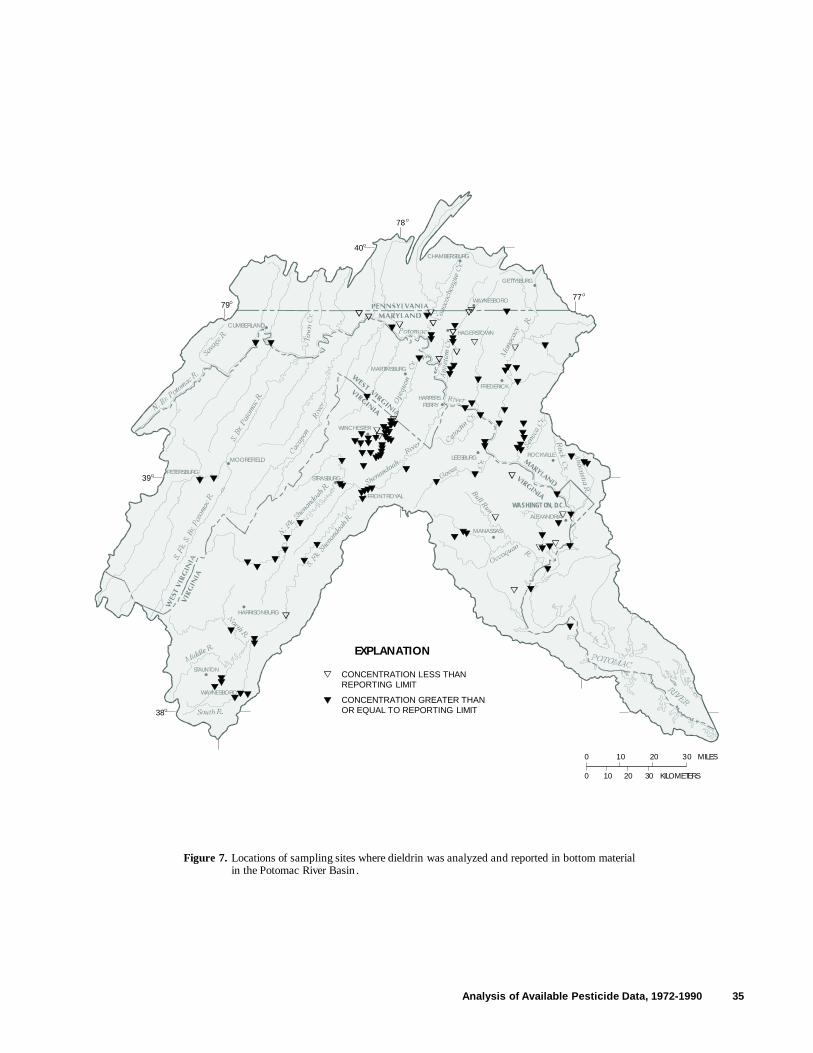
40O
39O
38O
79O
78O
77O
10 20 30 MILES
10 20 30 KILOMETERS0
0
HARRISONBURG
MOOREFIELD
WINCHESTER
MARTINSBURG
GETTYSBURG
FREDERICK
CUMBERLANDHAGERSTOWN
ALEXANDRIA
ROCKVILLELEESBURG
FRONT ROYAL
HARPERSFERRY
CHAMBERSBURG
STAUNTON
STRASBURG
WAYNESBORO
W A SHINGTON, D.C.
MANASSAS
PETERSBURG
EXPLANATION
CONCENTRATION LESS THANREPORTING LIMIT
CONCENTRATION GREATER THANOR EQUAL TO REPORTING LIMIT
Figure 7. Locations of sampling sites where dieldrin was analyzed and reported in bottom materialin the Potomac River Basin .
WAYNESBORO
Analysis of Available Pesticide Data, 1972-1990 35

40O
39O
38O
79O
78O
77O
10 20 30 MILES
10 20 30 KILOMETERS0
0
HARRISONBURG
MOOREFIELD
WINCHESTER
MARTINSBURG
GETTYSBURG
FREDERICK
CUMBERLANDHAGERSTOWN
ALEXANDRIA
ROCKVILLELEESBURG
FRONT ROYAL
HARPERSFERRY
CHAMBERSBURG
STAUNTON
STRASBURG
WAYNESBORO
W A SHINGTON, D.C.
MANASSAS
PETERSBURG
EXPLANATION
CONCENTRATION LESS THANREPORTING LIMIT
CONCENTRATION GREATER THANOR EQUAL TO REPORTING LIMIT
Figure 8. Locations of sampling sites where chlordane and related compounds were analyzed and reportedin bottom material in the Potomac River Basin.
WAYNESBORO
36 Water-Quality Assessment of the Potomac River Basin

40O
39O
38O
79O
78O
77O
10 20 30 MILES
10 20 30 KILOMETERS0
0
HARRISONBURG
MOOREFIELD
WINCHESTER
MARTINSBURG
GETTYSBURG
FREDERICK
CUMBERLANDHAGERSTOWN
ALEXANDRIA
ROCKVILLELEESBURG
FRONT ROYAL
HARPERSFERRY
CHAMBERSBURG
STAUNTON
STRASBURG
WAYNESBORO
W A SHINGTON, D.C.
MANASSAS
PETERSBURG
EXPLANATION
CONCENTRATION LESS THANREPORTING LIMIT
CONCENTRATION GREATER THANOR EQUAL TO REPORTING LIMIT
Figure 9. Locations of sampling sites where DDD, DDE, or DDT were analyzed an d reported in bottom materialin the Potomac River Basin.
WAYNESBORO
Analysis of Available Pesticide Data, 1972-1990 37

38 Water-Quality Assessment of the Potomac River Basin
Table 14. Summary of analyses for selected pesticides in ground-water samples collected by the U.S. Geological Survey, Potomac River Basin
[Parameter codes are from the U.S. Environmental Protection Agency’s STORET data-base-management system. µg/L, micrograms per liter; >, greater than or equal to. Reporting limits are concentrations at which analyzing laboratories report detection of a pesticide in water samples. NA, parameter code not applicable to this media; --, compound not analyzed in this media; DDT, dichloro-diphenyl-trichloroethane; DDE, dichlorodiphenyldichloroethylene; DDD, dichlorodiphenyldichloroethane]
Samples from wells Samples from springs
Total analyses Analyses with Total analyses Analyses with
performed for Reporting concentrations > performed for Reporting concentrations >
Pesticide Parameter code each pesticide limit (µg/L) reporting limit each pesticide limit (µg/L) reporting limit
2,4-D 39730 24 0.01 1 5 0.01 0
2,4,5-T 39740 24 .01 0 5 .01 0
Alachlor 77825 22 .1, .2 0 6 .1, .2 0
Aldrin 39330 64 .01 0 52 .001 0
Ametryne 82184 45 .1 0 8 .1 0
Atrazine 39630 45 .1 9 8 .1 4
γ-BHC (lindane) 39340 64 .01 0 52 .001 0
Chlordane 39350 64 .1 1 52 .1 0
Cyanazine 81757 NA NA NA 8 .1, .2 1
Cyanazine 77825 45 .1, .2 0 NA NA NA
DDD 39360 64 .01 0 52 .001 0
DDE 39365 64 .01 0 52 .001 5
DDT 39370 64 .01 0 52 .001 2
Diazinon 39570 64 .01 1 52 .01 1
Dieldrin 39380 64 .01 0 52 .001 8
Endosulfan 39388 63 .01 0 52 .001 1
Endrin 39390 64 .01 3 52 .001 4
Ethion 39398 64 .01 0 52 .01 0
Heptachlor 39410 64 .01 0 52 .001 0
Heptachlor epoxide 39420 64 .01 1 52 .001 0
Malathion 39530 64 .01 2 52 .01 0
Methomyl 39051 4 2 0 -- -- --

Analysis of Available Pesticide Data, 1972-1990 39
Table 14. Summary of analyses for selected pesticides in ground-water samples collected by the U.S. Geological Survey, Potomac River Basin--Continued
[Parameter codes are from the U.S. Environmental Protection Agency’s STORET data-base-management system. µg/L micrograms per liter; >, greater than or equal to. Reporting limits are concentrations at which analyzing laboratories report detection of a pesticide in water samples. -- compound not analyzed in this media; DDT, dichloro-diphenyl-trichloroethane; DDE, dichlorodiphenyldichloroethylene; DDD, dichlorodiphenyldichloroethane]
Samples from wells Samples from springs
Total analyses Analyses with Total analyses Analyses with
performed for Reporting concentrations > performed for Reporting concentrations >
Pesticide Parameter code each pesticide limit (µg/L) reporting limit each pesticide limit (µg/L) reporting limit
Methoxychlor 39480 63 0.01 0 52 .01 0
Metolachlor 82612 30 .01, .2 0 6 .1, .2 0
Mirex 39755 63 .01 0 52 .01 0
Ethyl parathion 39540 64 .01 0 52 .01 0
Methyl parathion 39600 64 .01 0 52 .01 1
Perthane 39034 63 .1 0 52 .1 0
Prometon 39056 45 .1, .2 0 8 .1, .2 0
Prometryne 39057 45 .1 0 8 .1 0
Propazine 39024 45 .1 0 8 .1 0
Propham 39052 4 2 0 -- -- --
Sevin (carbaryl) 39750 4 2 0 -- -- --
Silvex 39760 24 .01 0 5 .01 0
Simazine 39055 45 .1, .2 0 8 .1 2
Simetryne 39054 45 .1 0 8 .1 0
Toxaphene 39400 64 1 0 52 1 0
Trithion 39786 64 .01 0 52 .01 0
Methyl trithion 39790 64 .01 0 52 .01 0
Total 18 29

40 Water-Quality Assessment of the Potomac River Basin
Table 15. Concentrations of pesticides equal to or greater than reporting limits in ground-water samples collected by the U.S. Geological Survey, Potomac River Basin, 1972 to 1990
[µg/L, micrograms per liter; Some well names were abbreviated to preserve anonymity of private owners. DDT, dichloro-diphenyl-trichloroethane; DDE, dichlorodiphenyldichloroethylene]
Site Site nameidentification as reported by Concentrationnumber investigating agency Date (µg/L)
Well Samples
2,4-D
394835077135001 649, Pa. 06/02/87 0.01
Atrazine
391809078044301 FF well, W. Va. 08/24/89 0.2392848077530601 JN well, W. Va. 08/22/89 .3393055078000601 DD well, W. Va. 08/23/89 .1393150077395801 WA Ci 113, Md. 08/17/83 .4393301077435501 WA Ci 147, Md. 05/21/87 .3393959077370301 WA Bj 105, Md. 05/19/87 .5394038077410201 WA Ai 74, Md. 05/21/87 .1394149077515001 WA Ag 65, Md. 05/19/87 .1394806077150901 601, Pa. 10/07/86 .1
Chlordane
391809078044301 FF well, W. Va. 08/24/89 0.1
Diazinon
392725077524701 ER well, W. Va. 08/21/89 0.06
Endrin
391332077484701 0372258 B well, W. Va. 07/27/88 0.031391449077531401 03742 WM well, W. Va. o7/26/88 .150391854077484601 037106 CR well, W. Va. 07/27/88 .015
Heptachlor epoxide
391809078044301 FF well, W. Va. 08/24/89 0.110
Malathion
392725077524701 ER well, W. Va. 08/21/89 0.01395046077142701 593, Pa. 06/03/87 .01

Analysis of Available Pesticide Data, 1972-1990 41
Table 15. Concentrations of pesticides equal to or greater than reporting limits in ground-water samples collected by the U.S. Geological Survey, Potomac River Basin, 1972 to 1990--Continued
[µg/L, micrograms per liter; Some well names were abbreviated to preserve anonymity of private owners. DDT, dichloro-diphenyl-trichloroethane; DDE, dichlorodiphenyldichloroethylene]
Site Site nameidentification as reported by Concentrationnumber investigating agency Date (µg/L)
Spring Samples
Atrazine
392333077550500 2005060, W. Va. 08/24/89 0.9392717077540901 Dunn Spring, W. Va. 08/23/89 .5392748078003202 Olean Spring at Old School, W. Va. 08/22/89 .2393309077392201 WA Cj 126, Md. 05/21/87 .1
Cyanazine
392333077550501 2005060, W. Va. 08/24/89 0.1
DDE
391413077572301 037252 Head Spring, W. Va. 12/21/88 0.001393335077582200 2001088, W. Va. 03/30/89 .004
06/22/89 .00210/02/89 .00112/18/89 .004
DDT
393335077582200 2001088, W. Va. 03/30/89 0.00312/18/89 .002
Diazinon
01636340 Morgan Springs near Berryville, Va. 05/15/86 0.01
Dieldrin
391153077545001 037270, Louthan Spring, W. Va. 07/29/88 0.001392124078050501 Isherwood Spring, W. Va. 03/29/89 .011
06/20/89 .00310/03/89 .01512/19/89 .01003/06/90 .012
391840077504001 037109 flowing spring (Kane), W. Va. 07/25/88 .002392748078003202 Olean Spring at Old School, W. Va. 08/22/89 .001
Endosulfan
393335077582200 2001088, W. Va. 06/22/89 0.010

Table 15. Concentrations of pesticides equal to or greater than reporting limits in ground-water samples collected by the U.S. Geological Survey, Potomac River Basin, 1972 to 1990--Continued
[µg/L, micrograms per liter; Some well names were abbreviated to preserve anonymity of private owners. DDT, dichloro-diphenyl-trichloroethane; DDE, dichlorodiphenyldichloroethylene]
Site Site nameidentification as reported by Concentrationnumber investigating agency Date (µg/L)
Spring Samples--Continued
Endrin
391655077493801 03788A Cattail Spring, W. Va. 07/27/88 0.018392124078050501 Isherwood Spring, W. Va. 10/03/89 .012
03/06/90 .015
392748078003202 Olean Spring at Old School, W. Va. 08/22/89 .005
Methyl parathion
391413077572301 037252 Head Spring, W. Va. 06/20/89 0.01
Simazine
392333077550501 2005060, W. Va. 08/24/89 0.1392717077540901 Dunn Spring, W. Va. 08/23/89 .1
were found in 52 of the wells. Of the 720 analy-ses performed, there were 120 occurrences of pesticide concentrations greater than the reporting limits. Just over half of these occurrences were from wells in orchard areas. The most frequently detected pesticide was endosulfan, followed by azinophos-methyl and methyl parathion. The highest concentration was of 2,4-D in a sample attributed to urban lawn or garden care. Other pesticides found were phosmet, 2,4,5-TP, glypho-sate, and simazine. Also, analyses for alachlor and paraquat were performed, but those pesticides were not reported in any samples.
Mostaghimi and others (1989) detected 21 of 22 pesticides at concentrations greater than reporting limits in their pre-BMP sampling of 8 wells in Westmoreland County, Va. Only cyana-zine, which was reportedly used in the watershed, was not found in any of 136 samples. Atrazine was the most commonly found pesticide (5 wells). Other pesticides detected included paraquat, flauz-ifop-butyl, sethoxydim, and carbofuran. Alachlor was detected at only trace concentrations.
42 Water-Quality Assessment of the Potomac River Basin
Fish Tissue
Fish tissue has been sampled in the Poto-mac River Basin to address contaminant issues of national, regional, and local concern. Various fish tissue types and groups of analytes have been used, depending on the objectives of the agency conducting the investigation. Site selection and location has also been influenced by study objec-tives, as well as jurisdictional constraints.
Whole fish
A total of 266 whole-fish samples at 48 sites from the Potomac River Basin were analyzed for up to 37 pesticides and their related compounds (tables 3, 16, and 17). Of those pesticides and related compounds, 30 were found at concentra-tions equal to or greater than reporting limits, from 38 of the 48 sites sampled.1
1. Pesticides or their related compounds with concentra-tions in whole-fish tissue samples less than the reporting limit have been included if considered as a detection of the pesticide or related compound by the investigating agency.

Analysis of Available Pesticide Data, 1972-1990 43
Table 16. Summary of analyses for selected pesticides in whole-fish tissue samples, Potomac River Basin
[mg/kg, milligrams per kilogram; >, greater than or equal to; Reporting limits are concentrations at which analyzing laboratories report detections of a pesticide in fish tissue samples. BHC, Benzene hexachloride; DDT, dichloro-diphenyl-trichloroethane; DDE, dichlorodiphenyldichloroethyl-ene; DDD, dichlorodiphenyldichloroethane; HCB, Hexachlorobenzene, PCA, Pentachloranisol; -- not available]
Number of sites Total analyses Reporting Analyses withsampled for performed for limit concentrations
Pesticide pesticides1 each pesticide (mg/kg) > reporting limit2
Aldrin 33 87 0.001, .002, .003, .01, .1 1α-BHC 35 236 .002, .0025, .01, .1 33β-BHC 8 30 .01 3γ-BHC (lindane) 43 246 .01 57δ-BHC 8 30 .002, .0025, .01 2Chlordane 30 197 .01, 1.0 154Cis-chlordane 18 59 .002, .01, .05 34Trans-chlordane 18 59 .0025, .01 32Nonachlor 8 10 .1 0Cis-nonachlor 18 59 .0025, .01 16Trans-nonachlor 18 59 .0025, .01 33Oxychlordane 18 56 .0025, .01 8Chlorpyrifos 12 14 .0025, .1 3Dacthal 23 199 .002, .009, .01 1DDT 30 197 .02, .1 9o,p’-DDT 8 30 .01 5p,p’-DDT 14 55 .01 18DDE 30 197 .07, .1 53o,p’-DDE 8 30 .01 2p,p’-DDE 18 69 .0025, .01 46DDD 30 197 .04,.1 11o,p’-DDD 8 30 .01 0p,p’-DDD 14 65 .01 35Dieldrin 48 266 .0025, .007, .01, .1 84Endosulfan 38 227 .004, .007, .1 0Endosulfan II 8 30 -- 0Endosulfan sulfate 8 30 -- 0Endrin 48 266 .0025, .004, .01, .1 19Endrin aldehyde 8 30 -- 0HCB 38 106 .002, .0025, .01, .1 6Heptachlor 38 116 .001, .0025, .007, .01, .1 6Heptachlor epoxide 42 231 .002, .0025, .004, .01, .1 31Isodrin 8 30 -- 0Methoxychlor 42 231 .0025, .1 1Mirex 35 210 .0025, .01, .05,.1 2PCA 13 23 .0025, .01 5Toxaphene 39 252 .1,.23, .5, 1.0 13
Total 723
1Whole fish were sampled at a total of 48 sites in the Potomac River Basin. Analyses for multiple compounds were often conducted on a single whole-fish sample from a site.
2Pesticides or their related compounds with concentrations in whole-fish samples less than the reporting limit have been included if considered as a detection of the pesticide or related compound by the investigating agency.

44 Water-Quality Assessment of the Potomac River Basin
Table 17. Concentrations of pesticides equal to or greater than reporting limits in whole-fish tissue samples, Potomac River Basin, 1972 to 1990
[mg/kg, milligrams per kilogram; USGS, U.S. Geological Survey; BHC, Benzene hexachloride; DDT, dichloro-diphenyl-trichloroethane; DDE, dichlorodiphenyldichloroethylene; DDD, dichlorodiphenyldichloroethane; HCB, Hexachlorobenzene; PCA, Pentachloranisol]
Site Site name1 Range inidentification as reported by Year(s) concentrationnumber investigating agency reported (mg/kg)
Aldrin
WVOP0042 Opequon Creek, 25 miles above mouth, W.Va. 1985 0.02α-BHC
POT1471 Potomac River, at eastern terminus of Whites Ferry, Md. 1979,80,81 0.0020-0.0080NEB0016 Anacostia River, Riverdale Road below gage, Md. 1980,84,87 .0020- .0080POT1595 Potomac River, USGS gage 01638500, Md. 1987 .0061MON0020 Monocacy River, Md. Route 28 1980,81,84,87 .0020 - .038MON0138 Monocacy River, Md. Route 355 1980,81, 87 .005 - .0026MON0269 Monocacy River, Briggs Ford Road, Md. 1980-82,87 .0020 - .0060MON0528 Monocacy River, USGS Gage 01639000, Md. 1980-82,84,87 .0030 - .016BPC0035 Big Pipe Creek, Md. Route 194 1981 .0020 - .0040POT1830 Potomac River, USGS Gage 01618000, Md. 1980,87, .0070 - .0294POT2386 Potomac River, USGS Gage 01613000, Md. 1979,87 .0040 - .0315ANT0203 Antietam Creek, near Funkstown, Md. 1979-80,84,87 .0060 - .2080ANT0354 Antietam Creek, Md. Route 60 1984 .0110CON0005 Conococheague Creek, Md. Route 68 1979-81 .0020 - .0030TOW0013 Town Creek, Md. Route 51 1981-82,85,87 .0020 - .0270TOW0030 Town Creek, USGS Gage 01609000, Md. 1979 .0030NBP0103 North Branch Potomac River, Md. Route 51 1980,84,87 .0040 - .1840WVSB0082 South Fork South Branch Potomac River, Moorefield, W.Va. 1983 .0112210 East Potomac River, Washington, D.C. 1987 .006553147 Potomac River, Potomac Park, North of Wilson Bridge 1987 .003983317 Potomac River, North Branch, Westernport, Md. 1987 .00811FWS00062 Potomac River, Little Falls, Md. 1977,81,83, .01
β-BHC
WVOP0042 Opequon Creek, 25 miles above mouth, W.Va. 1981 0.04 - 0.07WVSH0062 Shenandoah River, Shannondale Ferry, W.Va. 1981 .01
γ-BHC (lindane)
POT147 Potomac River, at eastern terminus of Whites Ferry, Md. 1984 0.0020NEB00163 Anacostia River, Riverdale Road below gage, Md. 1987 .0017 - .0020MON00203 Monocacy River, Md. Route 28 1980,87 .0008 - .010MON01383 Monocacy River, Md. Route 355 1980-81,85,87 .0019 - .0030MON0269 Monocacy River, Briggs Ford Road, Md. 1980,87 .0020 - .0023MON0528 Monocacy River, USGS Gage 01639000, Md. 1984-85,87 .0030 - .0040POT1830 Potomac River, USGS Gage 01618000, Md. 1987 .0027 - .0028POT23863 Potomac River, USGS Gage 01613000, Md. 1987 .0006 - .0023ANT0203 Antietam Creek, near Funkstown, Md. 1984-85 .0030 - .0050TOW00133 Town Creek, Md. Route 51 1982,87 .0004 - .0163147 Potomac River, Potomac Park, North of Wilson Bridge 1987 .0064

Analysis of Available Pesticide Data, 1972-1990 45
Table 17. Concentrations of pesticides equal to or greater than reporting limits in whole-fish tissue samples, Potomac River Basin, 1972 to 1990--Continued
[mg/kg, milligrams per kilogram; USGS, U.S. Geological Survey; BHC, Benzene hexachloride; DDT, dichloro-diphenyl-trichloroethane; DDE, dichlorodiphenyldichloroethylene; DDD, dichlorodiphenyldichloroethane; HCB, Hexachlorobenzene; PCA, Pentachloranisol]
Site Site name1 Range inidentification as reported by Year(s) concentrationnumber investigating agency reported (mg/kg)
δ-BHC
WVOP0022 Opequon Creek, near Tuscarora Creek, W.Va. 1984 0.037WVSB0082 South Fork South Branch Potomac River, Moorefield, W.Va. 1984 .048
Chlordane
POT1342 Potomac River, end of Violets Lock Road, Md. 1978 0.010 -0.100POT1471 Potomac River, at eastern terminus of Whites Ferry, Md. 1979-84 .026 - .268NEB0016 Anacostia River, Riverdale Road below gage, Md. 1980-85,87 .016 - .930RCM0111 Rock Creek, Md. Route 410 1981 .068POT1595 Potomac River, USGS gage 01638500, Md. 1987 .040POT1661 Potomac River, Md. Route 17 1989 .068 - .685MON0020 Monocacy River, Md. Route 28 1979-82,84,85,87 .020 - .087MON0138 Monocacy River, Md. Route 355 1979-85,87 .010 - .183MON0269 Monocacy River, Briggs Ford Road, Md. 1979-85.87 .012 - .741MON0528 Monocacy River, USGS Gage 01639000, Md. 1979-83,85 .011 - .226BPC0035 Big Pipe Creek, Md. Route 194 1981-82 .014 - .050POT1830 Potomac River, USGS Gage 01618000, Md. 1980-84,87,89 .012 - .174POT2386 Potomac River, USGS Gage 01613000, Md. 1980-84,87 .010 - .088ANT0203 Antietam Creek, near Funkstown, Md. 1979-85,87,89 .043 - .856ANT0354 Antietam Creek, Md. Route 60 1983-84 .280 -1.295CON0005 Conococheague Creek, Md. Route 68 1979-84 .019 - .163TOW0013 Town Creek, Md. Route 51 1979-84,87 .010 - .119TOW0030 Town Creek, USGS Gage 01609000, Md. 1979 .010 - .050NBP0085 North Branch Potomac River, at Spring Gap, Md. 1989 .071NBP0103 North Branch Potomac River, Md. Route 51 1979-84 .020 - .131
Cis-chlordane
WVOP0022 Opequon Creek, near Tuscarora Creek, W.Va. 1984 0.044WVOP0042 Opequon Creek, 25 miles above mouth, W.Va. 1981 .03WVSH0062 Shenandoah River, Shannondale Ferry, W.Va. 1983 .15WVSB0082 South Fork South Branch Potomac River, Moorefield, W.Va. 1983-84 .032 -.689WVSB0092 South Branch Potomac River, Springfield, W.Va. 1978,83 .02 - .09822104 East Potomac River, Washington, D.C. 1987 .1663147 Potomac River, Potomac Park, North of Wilson Bridge 1987 .04263313 Opequon Creek, Bedington, W.Va. 1987 .00842FBH Potomac River, Fletchers Boathouse, Washington, D.C. 1987 .07 - .12WSC Washington Ship Channel, Washington, D.C. 1987 .16 - .18BRA Anacostia River, Benning Road, Washington, D.C. 1987 .09 - .10LA Lower Anacostia River, Washington, D.C. 1987 .10 - .19WB Potomac River, Wilson Bridge, Md. 1987 .06 - .11FWS00062 Potomac River, Little Falls, Md. 1977,79,81,84 .01 - .09

46 Water-Quality Assessment of the Potomac River Basin
Table 17. Concentrations of pesticides equal to or greater than reporting limits in whole-fish tissue samples, Potomac River Basin, 1972 to 1990--Continued
[mg/kg, milligrams per kilogram; USGS, U.S. Geological Survey; BHC, Benzene hexachloride; DDT, dichloro-diphenyl-trichloroethane; DDE, dichlorodiphenyldichloroethylene; DDD, dichlorodiphenyldichloroethane; HCB, Hexachlorobenzene; PCA, Pentachloranisol]
Site Site name1 Range inidentification as reported by Year(s) concentrationnumber investigating agency reported (mg/kg)
Trans-chlordane
WVOP0022 Opequon Creek, near Tuscarora Creek, W.Va. 1984 0.015WVOP0042 Opequon Creek, 25 miles above mouth, W.Va. 1981 .03 -.09WVSH0062 Shenandoah River, Shannondale Ferry, W.Va. 1983 .13WVSB0082 South Fork South Branch Potomac River, Moorefield, W.Va. 1983-84 .015 -.465WVSB0092 South Branch Potomac River, Springfield, W.Va. 1978,83 .01 - .0522210 East Potomac River, Washington, D.C. 1987 .126 3147 Potomac River, Potomac Park, North of Wilson Bridge 1987 .02893313 Opequon Creek, Bedington, W.Va. 1987 .00433FBH Potomac River, Fletchers Boathouse, Washington, D.C. 1987 .05 - .13WSC Washington Ship Channel, Washington, D.C. 1987 .11 - .20BRA Anacostia River, Benning Road, Washington, D.C. 1987 .08 - .10LA Lower Anacostia River, Washington, D.C. 1987 .09 - .20WB Potomac River, Wilson Bridge, Md. 1987 .04 - .12FWS00062 Potomac River, Little Falls, Md. 1977,79,81,84 .01 - .04
Cis-nonachlor
WVOP0022 Opequon Creek, near Tuscarora Creek, W.Va. 1984 0.014WVSB0082 South Fork South Branch Potomac River, Moorefield, W.Va. 1983-84 .011 -.0222210 East Potomac River, Washington, D.C. 1987 .0523313 Opequon Creek, Bedington, W.Va. 1987 .00635FWS00062 Potomac River, Little Falls, Md. 1977,79,81,84 .01 - .03
Trans-nonachlor
WVOP0042 Opequon Creek, 25 miles above mouth, W.Va. 1985 0.03 -0.17WVSH0072 Shenandoah River, near Millville, W.Va. 1978 .020WVSB0082 South Fork South Branch Potomac River, Moorefield, W.Va. 1983-84 .023 -.06WVSB0092 South Branch Potomac River, Springfield, W.Va. 1978 .0202210 East Potomac River, Washington, D.C. 1987 .1583147 Potomac River, Potomac Park, North of Wilson Bridge 1987 .03223313 Opequon Creek, Bedington, W.Va. 1987 .0264FBH Potomac River, Fletchers Boathouse, Washington, D.C. 1987 .12 - .20WSC Washington Ship Channel, Washington, D.C. 1987 .17 - .28BRA Anacostia River, Benning Road, Washington, D.C. 1987 .09 - .11LA Lower Anacostia River, Washington, D.C. 1987 .14 - .18WB Potomac River, Wilson Bridge, Md. 1987 .09 - .10FWS00062 Potomac River, Little Falls, Md. 1977,79,81,84 .01 - .04
Oxychlordane
2210 East Potomac River, Washington, D.C. 1987 0.005623313 Opequon Creek, Bedington, W.Va. 1987 .00333FWS00062 Potomac River, Little Falls, Md. 1979,81,84 .01

Analysis of Available Pesticide Data, 1972-1990 47
Table 17. Concentrations of pesticides equal to or greater than reporting limits in whole-fish tissue samples, Potomac River Basin, 1972 to 1990--Continued
[mg/kg, milligrams per kilogram; USGS, U.S. Geological Survey; BHC, Benzene hexachloride; DDT, dichloro-diphenyl-trichloroethane; DDE, dichlorodiphenyldichloroethylene; DDD, dichlorodiphenyldichloroethane; HCB, Hexachlorobenzene; PCA, Pentachloranisol]
Site Site name1 Range inidentification as reported by Year(s) concentrationnumber investigating agency reported (mg/kg)
Chlorpyrifos
2210 East Potomac River, Washington, D.C. 1987 0.02393147 Potomac River, Potomac Park, North of Wilson Bridge 1987 .007933133 Opequon Creek, Bedington, W.Va. 1987 .0012
DacthalFWS00062 Potomac River, Little Falls, Md. 1979 0.01
DDT
POT1342 Potomac River, end of Violets Lock Road, Md. 1978 0.020POT1471 Potomac River, at eastern terminus of Whites Ferry, Md. 1980 .020MON0138 Monocacy River, Md. Route 355 1980 .002ANT0203 Antietam Creek, near Funkstown, Md. 1979-80,84,85 .046 -.205ANT0354 Antietam Creek, Md. Route 60 1984 .020
o,p’-DDT
WVSH0062 Shenandoah River, Shannondale Ferry, W.Va. 1981 0.01 -0.02WVSB0082 South Fork South Branch Potomac River, Moorefield, W.Va. 1983-84 .03 - .043WVSB0092 South Branch Potomac River, Springfield, W.Va. 1978, 81,83 .019
p,p’-DDT
WVOP0022 Opequon Creek, near Tuscarora Creek, W.Va. 1984 0.056WVSH0062 Shenandoah River, Shannondale Ferry, W.Va. 1983 .01WVSB0082 South Fork South Branch Potomac River, Moorefield, W.Va. 1983-84 .1 - .035WVSB0092 South Branch Potomac River, Springfield, W.Va. 1978,83 .017 -.03FBH Potomac River, Fletchers Boathouse, Washington, D.C. 1987 .05WSC Washington Ship Channel, Washington, D.C. 1987 .06FWS00062 Potomac River, Little Falls, Md. 1972,79,81,84 .02 - .18
DDE
POT1342 Potomac River, end of Violets Lock Road, Md. 1978 0.80 -0.160POT1471 Potomac River, at eastern terminus of Whites Ferry, Md. 1983-84,89 .074- .169NEB0016 Anacostia River, Riverdale Road below gage, Md. 1987 .016 -.097POT15953 Potomac River, USGS gage 01638500, Md. 1987 .034POT16613 Potomac River, Md. Route 17 1989 .022 -.142MON00203 Monocacy River, Md. Route 28 1979-80,84,87 .030 -.084MON01383 Monocacy River, Md. Route 355 1983,84,87 .027 -.082MON0155 Monocacy River, Reeds Mill Road, Md. 1989 .184MON0269 Monocacy River, Briggs Ford Road, Md. 1983.87 .074 -.076MON05283 Monocacy River, USGS Gage 01639000, Md. 1984,87 .060 -.097POT18303 Potomac River, USGS Gage 01618000, Md. 1984,87 .038 -.134POT2386 Potomac River, USGS Gage 01613000, Md. 1987 .098ANT0203 Antietam Creek, near Funkstown, Md. 1979-80,82-87,89 .121 -.661

48 Water-Quality Assessment of the Potomac River Basin
Table 17. Concentrations of pesticides equal to or greater than reporting limits in whole-fish tissue samples, Potomac River Basin, 1992 to 1990--Continued
[mg/kg, milligrams per kilogram; USGS, U.S. Geological Survey; BHC, Benzene hexachloride; DDT, dichloro-diphenyl-trichloroethane; DDE, dichlorodiphenyldichloroethylene; DDD, dichlorodiphenyldichloroethane; HCB, Hexachlorobenzene; PCA, Pentachloranisol]
Site Site name1 Range inidentification as reported by Year(s) concentrationnumber investigating agency reported (mg/kg)
DDE--ContinuedANT0354 Antietam Creek, Md. Route 60 1983-84 0.111 -0.146CON0005 Conococheague Creek, Md. Route 68 1981,84 .071 - .078TOW00133 Town Creek, Md. Route 51 1987 .011 - .030NBP01033 North Branch Potomac River, Md. Route 51 1987 .0101BNSF3 5 N F Shenandoah River, Va. Route 340, Front Royal, Va. 1988 .026
o,p’-DDE
WVSH0062 Shenandoah River, Shannondale Ferry, W.Va. 1983 0.02WVSB0092 South Branch Potomac River, Springfield, W.Va. 1981 .01
p,p’-DDE
WVOP0042 Opequon Creek, 25 miles above mouth, W.Va. 1981 0.02 - 0.11WVSH0062 Shenandoah River, Shannondale Ferry, W.Va. 1981,83, .32 - .49WVSH0072 Shenandoah River, near Millville, W.Va. 1978 .09 - .13WVSB0082 South Fork South Branch Potomac River, Moorefield, W.Va. 1984 .039WVSB0092 South Branch Potomac River, Springfield, W.Va. 1978,83 .06 - .2422104 East Potomac River, Washington, D.C. 1987 .3813147 Potomac River, Potomac Park, North of Wilson Bridge 1987 .079233134 Opequon Creek, Bedington, W. Va. 1987 .200FBH Potomac River, Fletchers Boathouse, Washington, D.C. 1987 .21 - .55WSC Washington Ship Channel, Washington, D.C. 1987 .28 - .63BRA Anacostia River, Benning Road, Washington, D.C. 1987 .10 - .24LA Lower Anacostia River, Washington, D.C. 1987 .15 - .35WB Potomac River, Wilson Bridge, Md. 1987 .20 - .25FWS00062 Potomac River, Little Falls, Md. 1972-73,77,79,81,84 .02 - .31
DDD
POT1342 Potomac River, end of Violets Lock Road, Md. 1978 0.060NEB0016 Anacostia River, Riverdale Road below gage, Md. 1983 .083 - .117MON0269 Monocacy River, Briggs Ford Road, Md. 1983 .054ANT0203 Antietam Creek, near Funkstown, Md. 1979-80,82-84 .06 - .750ANT0354 Antietam Creek, Md. Route 60 1983 .095
p,p’-DDD
WVOP0042 Opequon Creek, 25 miles above mouth, W.Va. 1981 0.06WVSH0062 Shenandoah River, Shannondale Ferry, W.Va. 1981,83 .02WVSB0082 South Fork South Branch Potomac River, Moorefield, W.Va. 1983 .01WVSB0092 South Branch Potomac River, Springfield, W.Va. 1981,83 .016 - .23FBH Potomac River, Fletchers Boathouse, Washington, D.C. 1987 .11 - .17WSC Washington Ship Channel, Washington, D.C. 1987 .22 - .36BRA Anacostia River, Benning Road, Washington, D.C. 1987 .11 - .12LA Lower Anacostia River, Washington, D.C. 1987 .13 - .20WB Potomac River, Wilson Bridge, Md. 1987 .09 - .12FWS00062 Potomac River, Little Falls, Md. 1972-73,77,79,81,84 .01 - .19

Analysis of Available Pesticide Data, 1972-1990 49
Table 17. Concentrations of pesticides equal to or greater than reporting limits in whole-fish tissue samples, Potomac River Basin, 1971 to 1990--Continued
[mg/kg, milligrams per kilogram; USGS, U.S. Geological Survey; BHC, Benzene hexachloride; DDT, dichloro-diphenyl-trichloroethane; DDE, dichlorodiphenyldichloroethylene; DDD, dichlorodiphenyldichloroethane; HCB, Hexachlorobenzene; PCA, Pentachloranisol]
Site Site name1 Range inidentification as reported by Year(s) concentrationnumber investigating agency reported (mg/kg)
Dieldrin
POT1342 Potomac River, end of Violets Lock Road, Md. 1978 0.007 - .020POT1471 Potomac River, at eastern terminus of Whites Ferry, Md. 1979-81 .007- .010NEB0016 Anacostia River, Riverdale Road below gage, Md. 1982-84 .007 - .042RCM0111 Rock Creek, Md. Route 410 1981 .011POT15953 Potomac River, USGS gage 01638500, Md. 1987 .0033MON0020 Monocacy River, Md. Route 28 1979-82,84,87 .007 - .012MON0138 Monocacy River, Md. Route 355 1979,81,84,87 .007 - .019MON0269 Monocacy River, Briggs Ford Road, Md. 1979,81-84.87 .007 - .019MON0528 Monocacy River, USGS Gage 01639000, Md. 1981-82,84,87 .007 - .025BPC0035 Big Pipe Creek, Md. Route 194 1981-82 .009POT18303 Potomac River, USGS Gage 01618000, Md. 1987 .0043POT2386 Potomac River, USGS Gage 01613000, Md. 1981 .010ANT0203 Antietam Creek, near Funkstown, Md. 1979-85 .009 - .130ANT0354 Antietam Creek, Md. Route 60 1983-84 .056 - .080CON0005 Conococheague Creek, Md. Route 68 1979 .0080WVOP0022 Opequon Creek, near Tuscarora Creek, W.Va. 1981 .030WVOP0042 Opequon Creek, 25 miles above mouth, W.Va. 1981 .02 - .032210 East Potomac River, Washington, D.C. 1987 .07313147 Potomac River, Potomac Park, North of Wilson Bridge 1987 .01583313 Opequon Creek, Bedington, W.Va. 1987 .00775 FBH Potomac River, Fletchers Boathouse, Washington, D.C. 1987 .01 - .03WSC Washington Ship Channel, Washington, D.C. 1987 .04 - .04BRA Anacostia River, Benning Road, Washington, D.C. 1987 .01 - .02LA Lower Anacostia River, Washington, D.C. 1987 .02WB Potomac River, Wilson Bridge, Md. 1987 .02 FWS00062
Potomac River, Little Falls, Md. 1972,73,77,79,81,84 .01 - .13
Endrin
MON0269 Monocacy River, Briggs Ford Road, Md. 1979,81.87 0.0040 -0.0060MON05283 Monocacy River, USGS Gage 01639000, Md. 1987 .0017ANT0203 Antietam Creek, near Funkstown, Md. 1979-85,87,89 .0040WVOP0022 Opequon Creek, near Tuscarora Creek, W.Va. 1984 .011WVOP0042 Opequon Creek, 25 miles above mouth, W.Va. 1981 .02 - .062210 East Potomac River, Washington, D.C. 1987 .00902WSC Washington Ship Channel, Washington, D.C. 1987 .01BRA Anacostia River, Benning Road, Washington, D.C. 1987 .01LA Lower Anacostia River, Washington, D.C. 1987 .01FWS00062 Potomac River, Little Falls, Md. 1977,79,81,84 .01 - .02
HCB
MON0138 Monocacy River, Md. Route 355 1984,85 0.0050MON0269 Monocacy River, Briggs Ford Road, Md. 1985 .00202210 East Potomac River, Washington, D.C. 1987 .005073147 Potomac River, Potomac Park, North of Wilson Bridge 1987 .00364 WVSB0082
South Fork South Branch Potomac River, Moorefield, W.Va. 1984 .011

50 Water-Quality Assessment of the Potomac River Basin
Table 17. Concentrations of pesticides equal to or greater than reporting limits in whole-fish tissue samples, Potomac River Basin, 1972 to 1990--Continued
[mg/kg, milligrams per kilogram; USGS, U.S. Geological Survey; BHC, Benzene hexachloride; DDT, dichloro-diphenyl-trichloroethane; DDE, dichlorodiphenyldichloroethylene; DDD, dichlorodiphenyldichloroethane; HCB, Hexachlorobenzene; PCA, Pentachloranisol]
Site Site name1 Range inidentification as reported by Year(s) concentrationnumber investigating agency reported (mg/kg)
Heptachlor
WVSB0082 South Fork South Branch Potomac River, Moorefield, W.Va. 1983 0.035FWS00062 Potomac River, Little Falls, Md. 1977,79,81,84 .01 - 0.03
Heptachlor epoxide
POT1471 Potomac River, at eastern terminus of Whites Ferry, Md. 1983 0.0040 - 0.0050NEB0016 Anacostia River, Riverdale Road below gage, Md. 1981,85 .0040 - .0920MON0020 Monocacy River, Md. Route 28 1984 .0040MON0138 Monocacy River, Md. Route 355 1983,84 .0060 - .0080MON0269 Monocacy River, Briggs Ford Road, Md. 1983,84 .0040 - .0110MON0528 Monocacy River, USGS Gage 01639000, Md. 1984 .0060POT1830 Potomac River, USGS Gage 01618000, Md. 1983 .0040 - .0060ANT0203 Antietam Creek, near Funkstown, Md. 1983-85 .0050 - .0080ANT0354 Antietam Creek, Md. Route 60 1984 .0090CON0005 Conococheague Creek, Md. Route 68 1983 .0040 - .0090TOW0013 Town Creek, Md. Route 51 1983 .0040WVOP0042 Opequon Creek, 25 miles above mouth, W.Va. 1981 .03WVSH0062 Shenandoah River, Shannondale Ferry, W.Va. 1983 .02WVSB0082 South Fork South Branch Potomac River, Moorefield, W.Va. 1983-84 .02 - .039WVSB0092 South Branch Potomac River, Springfield, W.Va. 1983 .012210 East Potomac River, Washington, D.C. 1987 .0157
Methoxychlor
2210 East Potomac River, Washington, D.C. 1987 0.00482Mirex
22103 East Potomac River, Washington, D.C. 1987 0.0022433133 Opequon Creek, Bedington, W.Va. 1987 0.00083
PCA2210 East Potomac River, Washington, D.C. 1987 0.02593147 Potomac River, Potomac Park, North of Wilson Bridge 1987 .0065933133 Opequon Creek, Bedington, W.Va. 1987 .0006233173 Potomac River, North Branch, Westernport, Md. 1987 .00178 FWS00062
Potomac River, Little Falls, Md. 1984 .01

Table 17. Concentrations of pesticides equal to or greater than reporting limits in whole-fish tissue samples, Potomac River Basin, 1972 to 1992--Continued
[mg/kg, milligrams per kilogram; USGS, U.S. Geological Survey; BHC, Benzene hexachloride; DDT, dichloro-diphenyl-trichloroethane; DDE, dichlorodiphenyldichloroethylene; DDD, dichlorodiphenyldichloroethane; HCB, Hexachlorobenzene; PCA, Pentachloranisol]
Site Site name1 Range inidentification as reported by Year(s) concentrationnumber investigating agency reported (mg/kg)
Toxaphene
MON0020 Monocacy River, Md. Route 28 1981 0.269MON0138 Monocacy River, Md. Route 355 1981 .240WVSH0062 Shenandoah River, Shannondale Ferry, W.Va. 1983 .23WVSB0092 South Branch Potomac River, Springfield, W.Va. 1983 .04FWS00062 Potomac River, Little Falls, Md. 1977,79,81,84 .10 -.60
1Site names for some sites were abstracted from site location descriptions provided by investigating agency.2Not actual site number used by investigating agency, the actual site number was not available.3Concentration of pesticide or related compound in whole-fish tissue sample is below reporting limit, but was quantified and reported by
investigating agency.4Reported value exceeds the highest calibration standard for the investigating agency’s analysis for this pesticide or related compound.5 Site number is abbreviated to facilitate entry into table. The actual site number is 1BNFS000.69.
The five pesticides and their related com-pounds that were most often greater than their reporting limits and were reported at the greatest number of sites in whole-fish samples were chlor-dane, DDT, dieldrin, BHC and heptachlor. In the remainder of this report, the term "chlordane" is used to include chlordane and its related com-pounds, cis-chlordane, trans-chlordane, cis-nonachlor, trans-nonachlor, nonachlor, and oxy-chlordane, singly or in combinations. DDT is used to include DDT and its related compounds, DDE, DDD, o,p'-DDT, p,p'-DDT, o,p'- DDE, p,p'-DDE, o,p'-DDD, and p,p'-DDD, singly or in combina-tions. Heptachlor is used to include heptachlor and its related compound, heptachlor epoxide, sin-gly or in combinations. BHC is used to refer to γ-BHC and its related compounds, α-BHC, β-BHC, and δ-BHC, singly or in combi-nations. Aldrin, chlorpyrifos, dacthal, endosulfan, endosulfan II, endosulfan sulfate, endrin, endrin aldehyde, HCB, isodrin, methoxychlor, mirex, PCA, and toxaphene either were reported in none or only a relatively few analyses and will not be described in great detail here (table 16). Several other pesticides were analyzed as part of special studies in four or less samples and were not greater
than reporting limits. These pesticides have not been included in this report.
Of the five most reported pesticides in whole-fish samples, chlordane was reported at the greatest number of sites and analyses for the indi-vidual compounds. Chlordane was reported at 35 of the 48 sites sampled and in 277 of 499 analyses for the individual compounds (tables 16 and 17). Chlordane was reported at sites throughout much of the Potomac River Basin, most often as total chlordane (table 17). Chlordane was reported in sites all along the mainstem Potomac River and at all but one site in the Monocacy River Basin (fig. 10). Chlordane was also reported at sites in parts of the North and South Branch Potomac River Basins, as well as at sites in the Northeast Branch Anacostia River, Anacostia River, and Rock Creek near Washington, D.C., Antietam, Town, and Conococheague Creeks draining portions of Mary-land and Pennsylvania, Opequon Creek in West Virginia, and the lower Shenandoah River.
DDT was the pesticide reported at the sec-ond highest number of sites in whole-fish tissue samples in the Potomac River Basin. DDT was
Analysis of Available Pesticide Data, 1972-1990 51

40O
39O
38O
79O
78O
77O
10 20 30 MILES
10 20 30 KILOMETERS0
0
HARRISONBURG
MOOREFIELD
WINCHESTER
MARTINSBURG
GETTYSBURG
WAYNESBORO
FREDERICK
CUMBERLAND HAGERSTOWN
ALEXANDRIA
ROCKVILLELEESBURG
FRONT ROYAL
HARPERSFERRY
CHAMBERSBURG
STAUNTON
STRASBURG
WAYNESBORO
W A SHINGTON, D.C.
MANASSAS
PETERSBURG
EXPLANATION
CONCENTRATION LESS THANREPORTING LIMIT
CONCENTRATION GREATER THANOR EQUAL TO REPORTING LIMIT
Figure 10. Locations of sampling sites where chlordane was analyzed and reported in whole-fish tissuein the Potomac River Basin.
52 Water-Quality Assessment of the Potomac River Basin

reported at 33 of 48 sites sampled and in 179 of 870 analyses performed for the individual com-pounds, usually as some form of DDE (tables 16 and 17). DDT was reported at sites along the mid-dle and lower mainstem Potomac River and nearly all sites in the Monocacy River Basin (fig. 11). DDT was also reported at sites in the North and South Branch Potomac River Basins, as well as the Northeast Branch Anacostia and mainstem Ana-costia Rivers near Washington, D.C., Antietam, Town, and Conococheague Creeks draining por-tions of Maryland and Pennsylvania, Opequon Creek in West Virginia, and at sites in the North Fork Shenandoah River and the lower portions of the Shenandoah River.
Dieldrin was reported at the third highest number of sites in whole-fish tissue samples in the Potomac River Basin. Dieldrin was reported at 26 of 48 sites sampled and in 84 of 266 analyses per-formed (tables 16 and 17). Dieldrin was reported at sites along the middle and lower mainstem Potomac River and all but one site in the Mono-cacy River Basin (fig. 12). Dieldrin was also reported in the Northeast Branch Anacostia River, Anacostia River, and Rock Creek near Washing-ton, D.C., Antietam, and Conococheague Creeks draining parts of Maryland and Pennsylvania, and Opequon Creek in West Virginia.
BHC was the pesticide reported at the fourth highest number of sites in whole-fish tissue sam-ples in the Potomac River Basin. BHC was reported at 24 of 43 sites sampled and in 95 of 542 analyses performed for the individual compounds, most often as α-BHC (tables 16 and 17). BHC was reported at most of the sites along the main-stem Potomac River and all but one site in the Monocacy River Basin (fig. 13). BHC was reported at two sites in the North Branch Potomac River and one site in the South Branch Potomac River Basin, as well as at sites in the Northeast Branch Anacostia River, Antietam, Town, and Conococheague Creeks draining portions of Mary-land and Pennsylvania, Opequon Creek in West Virginia, and the lower Shenandoah River.
Heptachlor was the pesticide reported at the fifth highest number of sites in whole-fish tissue samples in the Potomac River Basin. Heptachlor
was reported at 17 of 43 sites sampled and in 37 of 347 analyses performed for the individual com-pound, usually as heptachlor epoxide (tables 16 and 17). Heptachlor was reported at several sites along the mainstem Potomac River and at all but two sites in the Monocacy River Basin (fig. 14). Heptachlor was reported at sites in the South Branch Potomac River Basin, Northeast Branch Anacostia River near Washington, D.C., Anti-etam, Town, and Conococheague Creeks draining portions of Maryland and Pennsylvania, Opequon Creek in West Virginia, and in the lower Shenan-doah River.
Fish Fillets
A total of 197 fish-fillet samples were ana-lyzed for up to 34 pesticides and their related compounds from 44 sites in the Potomac River Basin (tables 3, 18, and 19). Of those pesticides and related compounds, 15 were found at concen-trations equal to or greater than limits, from 30 of the 44 sites sampled 2 (tables 3, 18, and 19).
The five pesticides and their related com-pounds that were most often greater than their reporting limits and were reported at the greatest number of sites in fish-fillet samples were chlor-dane, DDT, dieldrin, BHC, and heptachlor. Aldrin, chlorpyrifos, dacthal, endosulfan, endrin, HCB, methoxychlor, mirex, PCA, and toxaphene were reported in either none or only few analyses and will not be presented here.
Of the five most-reported pesticides in fish-fillet samples, chlordane was reported at the great-est number of sites and analyses for the individual compounds. Chlordane was reported at 27 of 44 sites sampled and in 94 of 275 analyses performed for the individual compounds, usually as total chlordane (tables 18 and 19). Chlordane was reported in most sites along the mainstem Poto-mac River and in all but one site in the Monocacy River Basin (fig. 15). Chlordane was also reported in sites in the North Branch Potomac River,
2. Pesticides or their related compounds with concentrations in fish-fillet tissue samples less than the reporting limit have been included if considered as a detection of the pesticide or related compound by the investigating agency.
Analysis of Available Pesticide Data, 1972-1990 53

40O
39O
38O
79O
78O
77O
10 20 30 MILES
10 20 30 KILOMETERS0
0
HARRISONBURG
MOOREFIELD
WINCHESTER
MARTINSBURG
GETTYSBURG
WAYNESBORO
FREDERICK
CUMBERLAND HAGERSTOWN
ALEXANDRIA
ROCKVILLELEESBURG
FRONT ROYAL
HARPERSFERRY
CHAMBERSBURG
STAUNTON
STRASBURG
WAYNESBORO
W A SHINGTON, D.C.
MANASSAS
PETERSBURG
EXPLANATION
CONCENTRATION LESS THANREPORTING LIMIT
CONCENTRATION GREATER THANOR EQUAL TO REPORTING LIMIT
Figure 11. Locations of sampling sites where DDT was analyzed and reported in whole-fish tissuein the Potomac River Basin.
54 Water-Quality Assessment of the Potomac River Basin

40O
39O
38O
79O
78O
77O
10 20 30 MILES
10 20 30 KILOMETERS0
0
HARRISONBURG
MOOREFIELD
WINCHESTER
MARTINSBURG
GETTYSBURG
WAYNESBORO
FREDERICK
CUMBERLAND HAGERSTOWN
ALEXANDRIA
ROCKVILLELEESBURG
FRONT ROYAL
HARPERSFERRY
CHAMBERSBURG
STAUNTON
STRASBURG
WAYNESBORO
W A SHINGTON, D.C.
MANASSAS
PETERSBURG
EXPLANATION
CONCENTRATION LESS THANREPORTING LIMIT
CONCENTRATION GREATER THANOR EQUAL TO REPORTING LIMIT
Figure 12. Locations of sampling sites where dieldrin was analyzed and reported in whole-fish tissuein the Potomac River Basin.
Analysis of Available Pesticide Data, 1972-1990 55

40O
39O
38O
79O
78O
77O
10 20 30 MILES
10 20 30 KILOMETERS0
0
HARRISONBURG
MOOREFIELD
WINCHESTER
MARTINSBURG
GETTYSBURG
WAYNESBORO
FREDERICK
CUMBERLAND HAGERSTOWN
ALEXANDRIA
ROCKVILLELEESBURG
FRONT ROYAL
HARPERSFERRY
CHAMBERSBURG
STAUNTON
STRASBURG
WAYNESBORO
W A SHINGTON, D.C.
MANASSAS
PETERSBURG
EXPLANATION
CONCENTRATION LESS THANREPORTING LIMIT
CONCENTRATION GREATER THANOR EQUAL TO REPORTING LIMIT
Figure 13. Locations of sampling sites where BHC was analyzed and reported in whole-fish tissuein the Potomac River Basin.
56 Water-Quality Assessment of the Potomac River Basin

40O
39O
38O
79O
78O
77O
10 20 30 MILES
10 20 30 KILOMETERS0
0
HARRISONBURG
MOOREFIELD
WINCHESTER
MARTINSBURG
GETTYSBURG
WAYNESBORO
FREDERICK
CUMBERLAND HAGERSTOWN
ALEXANDRIA
ROCKVILLELEESBURG
FRONT ROYAL
HARPERSFERRY
CHAMBERSBURG
STAUNTON
STRASBURG
WAYNESBORO
W A SHINGTON, D.C.
MANASSAS
PETERSBURG
EXPLANATION
CONCENTRATION LESS THANREPORTING LIMIT
CONCENTRATION GREATER THANOR EQUAL TO REPORTING LIMIT
Figure 14. Locations of sampling sites where heptachlor was analyzed and reported in whole-fish tissuein the Potomac River Basin .
Analysis of Available Pesticide Data, 1972-1990 57

58 Water-Quality Assessment of the Potomac River Basin
Table 18. Summary of analyses for selected pesticides in fish-fillet tissue samples, Potomac River Basin, 1972 to 1990
[mg/kg, milligrams per kilogram; >, greater than or equal to; Reporting limits are concentrations at which analyzing laboratories report detection of a pesticide in fish tissue samples. BHC, Benzene hexachloride; DDT, dichloro-diphenyl-trichloroethane; DDE, dichlorodiphenyldichloroethylene; DDD, dichlorodiphenyldichloroethane; HCB, Hexachlorobenzene; PCA, Pentachloranisol]
Number of sites Total analyses Reporting Analyses withsampled for performed for limit concentrations
Pesticide pesticide1 each pesticide (mg/kg) > reporting limit2
Aldrin 20 47 0.002, .005, .01,.1 0α-BHC 21 74 .002, .0025, .005, .01 ,.1 16γ-BHC (lindane) 29 94 .002, .0025, .005, .01 3Chlordane 34 182 .01, .1, .5, 1.0 68Cis-chlordane 10 15 .0025, .005, .02, .05 4Trans-chlordane 10 15 .0025, .005, .01, .02 7Nonachlor 8 20 .1 0Cis-nonachlor 10 15 .0025, .005, .01, .02 5Trans-nonachlor 8 13 .0025, .01, .02 9Oxychlordane 10 15 .0025, .005, .01, .02 1Total chlordene 4 4 .005, .02 0α-Chlordene 4 4 .008, .02 0γ-Chlordene 4 4 .005, .02 0Chlorpyrifos 9 21 .0025, .1 0Dacthal 16 69 .002, .009 0DDT 24 89 .02, .1 0o,p’-DDT 2 2 .04 0p,p’-DDT 9 14 .04, .01 3DDE 24 89 .07, .1 21o,p’-DDE 2 2 .02 0p,p’-DDE 10 15 .0025, .01, .02 11DDD 24 89 .04, .1 0o,p’-DDD 2 2 .02 0p,p’-DDD 9 14 .01, .02 7Dieldrin 34 104 .001, .0025, .007, .01, .02 ,.1 19Endosulfan 24 89 .002,. 004, .007, .1 0Endrin 34 104 .001, .0025, .004, .01, .02, .1 0HCB 17 44 .002, .0025, .1 0Heptachlor 21 48 .001, .0025, .005, .01, .1 0Heptachlor epoxide 29 94 .002, .0025, .004, .005, .01, .1 14Methoxychlor 29 94 .0025, .05, .1 0Mirex 27 92 .0025, .02, .05, .1 0PCA 9 21 .0025, .01 0Toxaphene 24 89 .23, .5, 1.0 3
Total 191
1 Fish-fillet tissue was sampled at a total of 44 sites in the Potomac River Basin. Analyses for multiple compounds were often conducted on a single fish-fillet sample from a site.
2Pesticides or their related compounds with concentrations in fish-fillet samples less than the reporting limit have been included if considered as a detection of the pesticide or related compound by the investigating agency.

Analysis of Available Pesticide Data, 1972-1990 59
Table 19. Concentrations of pesticides equal to or greater than reporting limits in fish-fillet tissue samples, Potomac River Basin, 1972 to 1990
[mg/kg, milligrams per kilogram; USGS, U.S. Geological Survey; BHC, Benzene hexachloride; DDT, dichloro-diphenyl-trichloroethane; DDE, dichlorodiphenyldichloroethylene; DDD, dichlorodiphenyldichloroethane]
Site Site name1 Range inidentification as reported by Year(s) concentrationnumber investigating agency reported (mg/kg)
α-BHC
RCM0111 Rock Creek, Md. Route 410 1984 0.0040MON0020 Monocacy River, Md. Route 28 1981 .0020MON0528 Monocacy River, USGS Gage 01639000, Md. 1984,87 .0020-.0030BPC0035 Big Pipe Creek, Md. Route 194 1981 .0030POT1830 Potomac River, USGS Gage 01618000, Md. 1981 .0040ANT0354 Antietam Creek, Md. Route 60 1984 .0020-.0050CON0005 Conococheague Creek, Md. Route 68 1981 .0030
γ-BHC (lindane)
RCM0111 Rock Creek, Md. Route 410 1984 0.2420MON01382 Monocacy River, Md. Route 355 1987 .0010MON05282 Monocacy River, USGS Gage 01639000, Md. 1987 .0010
Chlordane
POT14713 Potomac River, at eastern terminus of Whites Ferry, Md. 1981 0.016-0.105RCM0111 Rock Creek, Md. Route 410 1984 .082- .328POT16613 Potomac River, Md. Route 17 1989 .010- .521POT1707 Potomac River, US Route 340 Bridge, Md. 1977 .010- .110MON0020 Monocacy River, Md. Route 28 1981 .014- .142MON0138 Monocacy River, Md. Route 355 1981,87 .017- .023MON0155 Monocacy River, Reeds Mill Road, Md. 1989 .115MON0528 Monocacy River, USGS Gage 01639000, Md. 1981,84,87 .015- .141BPC0035 Big Pipe Creek, Md. Route 194 1981 .019- .023POT1830 Potomac River, USGS Gage 01618000, Md. 1981,89 .020- .071POT2386 Potomac River, USGS Gage 01613000, Md. 1981 .033ANT0203 Antietam Creek, near Funkstown, Md. 1981 .018ANT0354 Antietam Creek, Md. Route 60 1984 .051- .132CON0005 Conococheague Creek, Md. Route 68 1981,89 .016- .084NBP0085 North Branch Potomac River, at Spring Gap, Md. 1989 .068- .093WDC00013,4 Potomac River, Fletchers Boathouse, Washington, D.C. 1986 .50WDC00023,4 Potomac River, Limit Island Marina, Washington, D.C. 1986 1.61WDC00044 Lower Anacostia River, Washington, D.C. 1986 .05WDC00053,4 Anacostia River, Benning Road, Washington, D.C. 1986 .05- 1.00WDC00084 Northeast & Northeast Anacostia River, Confluence, Md. 1986 .09- .17WDC00103,4 Potomac River, Carder Rocks, Md. 1986 .40
Cis-chlordane
33132 Opequon Creek, Bedington, W. Va. 1987 0.00073FBH3,5 Potomac River, Fletchers Boathouse, Washington, D.C. 1987 .098LA3,5 Lower Anacostia River, Washington, D.C. 1987 .22WB Potomac River, Wilson Bridge, Md. 1987 .081

60 Water-Quality Assessment of the Potomac River Basin
Table 19. Concentrations of pesticides equal to or greater than reporting limits in fish-fillet tissue samples, Potomac River Basin, 1972 to 1990--Continued
[mg/kg, milligrams per kilogram; USGS, U.S. Geological Survey; BHC, Benzene hexachloride; DDT, dichloro-diphenyl-trichloroethane; DDE, dichlorodiphenyldichloroethylene; DDD, dichlorodiphenyldichloroethane]
Site Site name1 Range inidentification as reported by Year(s) concentrationnumber investigating agency reported (mg/kg)
Trans-chlordane
33132 Opequon Creek, Bedington, W. Va. 1987 0.00203FBH Potomac River, Fletchers Boathouse, Washington, D.C. 1987 .048WSC Washington Ship Channel, Washington, D.C. 1987 .036BRA Anacostia River, Benning Road, Washington, D.C. 1987 .039LA Lower Anacostia River, Washington, D.C. 1987 .16WB Potomac River, Wilson Bridge, Md. 1987 .032-.053
Cis-nonachlor
FBH Potomac River, Fletchers Boathouse, Washington, D.C. 1987 0.062WSC Washington Ship Channel, Washington, D.C. 1987 .024BRA Anacostia River, Benning Road, Washington, D.C. 1987 .024LA Lower Anacostia River, Washington, D.C. 1987 .082WB Potomac River, Wilson Bridge, Md. 1987 .033
Trans-nonachlor
3313 Opequon Creek, Bedington, W. Va. 1987 0.00416FBH Potomac River, Fletchers Boathouse, Washington, D.C. 1987 .037- .15WSC Washington Ship Channel, Washington, D.C. 1987 .020- .033BRA Anacostia River, Benning Road, Washington, D.C. 1987 .017LA Lower Anacostia River, Washington, D.C. 1987 .16WB Potomac River, Wilson Bridge, Md. 1987 .037- .064
Oxychlordane
33132 Opequon Creek, Bedington, W. Va. 1987 0.00203
p,p’-DDT
FBH Potomac River, Fletchers Boathouse, Washington, D.C. 1987 0.069LA Lower Anacostia River, Washington, D.C. 1987 .051WB Potomac River, Wilson Bridge, Md. 1987 .031
DDE
POT14712 Potomac River, at eastern terminus of Whites Ferry, Md. 1979,81,89 0.005-0.082POT16612 Potomac River, Md. Route 17 1989 .019- .132MON0020 Monocacy River, Md. Route 28 1981 .077MON01382 Monocacy River, Md. Route 355 1987,89 .006MON01552 Monocacy River, Reeds Mill Road, Md. 1989 .012- .095MON05282 Monocacy River, USGS Gage 01639000, Md. 1987,89 .008- .044CON00052 Conococheague Creek, Md. Route 68 1979-84,89 .006- .0721BSSF6 South Fork Shenandoah River, Route 340, Front Royal, Va. 1988 .11

Analysis of Available Pesticide Data, 1972-1990 61
Table 19. Concentrations of pesticides equal to or greater than reporting limits in fish-fillet tissue samples, Potomac River Basin, 1972 to 1990--Continued
[mg/kg, milligrams per kilogram; USGS, U.S. Geological Survey; BHC, Benzene hexachloride; DDT, dichloro-diphenyl-trichloroethane; DDE, dichlorodiphenyldichloroethylene; DDD, dichlorodiphenyldichloroethane]
Site Site name1 Range inidentification as reported by Year(s) concentrationnumber investigating agency reported (mg/kg)
p,p’-DDE
WQN0501 Conococheague Creek, near Worleytown, Pa. 1989 0.0223313 Opequon Creek, Bedington, W. Va. 1987 .01948FBH Potomac River, Fletchers Boathouse, Washington, D.C. 1987 .036-.33WSC Washington Ship Channel, Washington, D.C. 1987 .039-.093BRA Anacostia River, Benning Road, Washington, D.C. 1987 .076LA Lower Anacostia River, Washington, D.C. 1987 .049-.31WB Potomac River, Wilson Bridge, Md. 1987 .051-.17
p,p’-DDD
FBH Potomac River, Fletchers Boathouse, Washington, D.C. 1987 0.10WSC Washington Ship Channel, Washington, D.C. 1987 .034-.050BRA Anacostia River, Benning Road, Washington, D.C 1987 .042LA Lower Anacostia River, Washington, D.C. 1987 .14WB Potomac River, Wilson Bridge, Md. 1987 .048-.072
Dieldrin
POT1471 Potomac River, at eastern terminus of Whites Ferry, Md. 1981 0.0070RCM0111 Rock Creek, Md. Route 410 1984 .0130-.0170MON0528 Monocacy River, USGS Gage 01639000, Md. 1984 .007- .0210POT1830 Potomac River, USGS Gage 01618000, Md. 1981 .0100ANT0354 Antietam Creek, Md. Route 60 1984 .0120-.0200TOW0013 Town Creek, Md. Route 51 1981 .007FBH Potomac River, Fletchers Boathouse, Washington, D.C. 1987 .031WSC Washington Ship Channel, Washington, D.C. 1987 .023LA Lower Anacostia River, Washington, D.C. 1987 .052WB Potomac River, Wilson Bridge, Md. 1987 .037- .041
Heptachlor epoxide
RCM0111 Rock Creek, Md. Route 410 1981,84 0.0040-0.0440MON0528 Monocacy River, USGS Gage 01639000, Md. 1984 .0040- .0050ANT0354 Antietam Creek, Md. Route 60 1984 .0040- .0090

Table 19. Concentrations of pesticides equal to or greater than reporting limits in fish-fillet tissue samples, Potomac River Basin, 1972 to 1990--Continued
[mg/kg, milligrams per kilogram; USGS, U.S. Geological Survey; BHC, Benzene hexachloride; DDT, dichloro-diphenyl-trichloroethane ; DDE, dichlorodiphenyldichloroethylene; DDD, dichlorodiphenyldichloroethane]
Site Site name1 Range inidentification as reported by Year(s) concentrationnumber investigating agency reported (mg/kg)
Toxaphene
POT1471 Potomac River, at eastern terminus of Whites Ferry, Md. 1981 0.0261MON0020 Monocacy River, Md. Route 28 1981 .333
1Site names for some sites were abstracted from site location descriptions provided by investigating agency.2Concentration of pesticide or related compound in fish-fillet tissue sample is below reporting limit, but was quantified and reported by
investigating agency.3Concentration of pesticide in fish-fillet tissue sample exceeds the action level for protection of human health as set forth by the U.S. Food and
Drug Administration (Nowell and Resek, 1994).4Not actual site number used by investigating agency; the actual site number was not available.5For this site, all concentrations of chlordane and related compounds must be added to obtain the total concentration value in the fish-fillet tissue
sample that exceeds the U.S. Food and Drug Administration’s action level for protection of human health, to include chlordane, cis-chlordane, trans-chlordane, cis-nonachlor, trans-nonachlor, and oxychlordane. The individual values for each compound must be quantified to 0.02 parts per million before their values can be added (Nowell and Resek, 1994).
6Site number is abbreviated to facilitate entry into table. The actual site number is 1BSSF019.30.
Anacostia River, and Rock Creek near Wash-ington, D.C., Antietam, and Conococheague Creeks draining portions of Maryland and Penn-sylvania, and Opequon Creek in West Virginia.
Chlordane was the only pesticide or related compound analyzed in fish-fillet samples in the Potomac River Basin that exceeded existing Food and Drug Administration (FDA) standards for the protection of human health in edible portions. The standard for chlordane is 0.3 mg/kg (Nowell and Resek, 1994). Chlordane exceeded the FDA stan-dard for the protection of human health at eight sites. All but one of the sites were located on the lower Potomac River, Anacostia River or Rock Creek at or near Washington, D.C. (table 19, fig-ure 15). The remaining site, was located on the Potomac River upstream of Washington, D.C.
The District of Columbia Department of Consumer and Regulatory Affairs issued a health advisory in 1989 to encompass the portions of the Potomac River, Anacostia River, Rock Creek, and their tributaries within the District of Columbia, due to "PCB's and other contaminants" (H. Karimi, District of Columbia Department of Consumer and Regulatory Affairs, written commun., 1994). The
62 Water-Quality Assessment of the Potomac River Basin
1989 health advisory limited consumption of cat-fish, carp, or eel to a half pound per week, without limits on other fish species. The District of Colum-bia Department of Consumer and Regulatory Affairs has recently updated the 1989 health advi-sory, and advises that no catfish, carp, or eel be consumed and to limit consumption of largemouth bass to one half pound per month, or one half pound of sunfish or other fish per week (H. Karimi, District of Columbia Department of Con-sumer and Regulatory Affairs, written commun., 1994).
DDT was the pesticide reported at the sec-ond highest number of sites in fish-fillet samples in the Potomac River Basin. DDT was reported at 15 of 34 sites sampled and in 42 of 316 analyses performed for the individual compounds, usually as some form of DDE (tables 18 and 19). DDT was reported at sites in the middle and lower main-stem Potomac River and at four sites in the Monocacy River Basin (fig. 16). DDT was also reported in the Anacostia River near Washington, D.C., Conococheague Creek draining portions of Maryland and Pennsylvania, Opequon Creek in West Virginia, and South Fork Shenandoah River.

40O
39O
38O
79O
78O
77O
10 20 30 MILES
10 20 30 KILOMETERS0
0
HARRISONBURG
MOOREFIELD
WINCHESTER
MARTINSBURG
GETTYSBURG
WAYNESBORO
FREDERICK
CUMBERLAND HAGERSTOWN
ALEXANDRIA
ROCKVILLELEESBURG
FRONT ROYAL
HARPERSFERRY
CHAMBERSBURG
STAUNTON
STRASBURG
WAYNESBORO
W A SHINGTON, D.C.
MANASSAS
PETERSBURG
EXPLANATION
CONCENTRATION LESS THANREPORTING LIMIT
CONCENTRATION GREATER THANOR EQUAL TO REPORTING LIMIT
Figure 15. Locations of sampling sites where chlordane was analyzed and reported in fish-fillet tissuein the Potomac River Basin.
Analysis of Available Pesticide Data, 1972-1990 63

40O
39O
38O
79O
78O
77O
10 20 30 MILES
10 20 30 KILOMETERS0
0
HARRISONBURG
MOOREFIELD
WINCHESTER
MARTINSBURG
GETTYSBURG
WAYNESBORO
FREDERICK
CUMBERLAND HAGERSTOWN
ALEXANDRIA
ROCKVILLELEESBURG
FRONT ROYAL
HARPERSFERRY
CHAMBERSBURG
STAUNTON
STRASBURG
WAYNESBORO
W A SHINGTON, D.C.
MANASSAS
PETERSBURG
EXPLANATION
CONCENTRATION LESS THANREPORTING LIMIT
CONCENTRATION GREATER THANOR EQUAL TO REPORTING LIMIT
Figure 16. Locations of sampling sites where DDT was analyzed and reported in fish-fillet tissuein the Potomac River Basin.
64 Water-Quality Assessment of the Potomac River Basin

Dieldrin was the pesticide reported at the third highest number of sites in fish-fillet samples in the Potomac River Basin. Dieldrin was reported at 10 of 34 sites sampled and in 19 of 104 analyses performed (tables 18 and 19). Dieldrin was reported at sites in the middle and lower Potomac River (fig. 17). Near Washington, D.C., dieldrin was reported in the lower Anacostia River and Rock Creek. Dieldrin was reported at one site in the Monocacy River Basin, and at Antietam and Town Creeks draining portions of Maryland and Pennsylvania.
BHC was the pesticide reported at the fourth highest number of sites in fish-fillet samples in the Potomac River Basin. BHC was reported at 8 of 29 sites sampled and in 19 of 168 analyses per-formed for the individual compounds (tables 18 and 19). BHC was most often reported as α-BHC (tables 18 and 19). BHC was reported at one site in the mainstem Potomac River (fig. 18). BHC was also reported at four sites in the Monocacy River Basin, in Rock Creek near Washington, D.C., and Antietam and Conococheague Creeks draining portions of Maryland and Pennsylvania.
Heptachlor was the pesticide reported at the fifth highest number of sites in fish-fillet samples in the Potomac River Basin. Heptachlor was reported 3 of 29 sites sampled and in 14 of 142 analyses performed for the individual compounds, as heptachlor epoxide (tables 3, 18 and 19). Hep-tachlor was reported in the Monocacy River Basin, Antietam Creek draining parts of Maryland and Pennsylvania, and in Rock Creek near Washing-ton, D.C. (fig. 19).
Evaluation of Existing Pesticide Data Coverage
If pesticide concentration data for surface water, bottom material, ground water, and fish tis-sue exist on sufficient spatial and temporal scales, the data can be used for problem identification, comparison with national conditions, detection of differences between major basin subunits, and detection of trends. The assessment of the current status of water quality is a primary goal of NAWQA and the Potomac River Basin study unit. Because the uncontrolled presence of pesticides in
the environment is almost always of concern, it can be said that a problem exists wherever pesti-cides are detected in water, bottom material, or fish tissues. Usually, however, problems are defined by comparison with a regulatory standard or other environmental benchmark. Comparisons with national conditions or between regions or other landscape subunits also helps in the defini-tion of water-quality status. Trends detection, on the other hand, requires data from multiple sam-ples over time for a single location.
Objective definition of water-quality prob-lems due to pesticides in the Potomac River Basin using the available data is difficult because of dif-fering approaches to data collection, laboratory analysis, and data management, and because regu-latory standards or other satisfactory benchmarks are not available for many pesticides. Rather, dis-cussion in this report is limited to an assessment of the usefulness of existing data for making these determinations. Comparisons with national condi-tions will be done by the NAWQA Pesticides National Synthesis Project. Comparisons between major basin subunits and the ability to detect trends will be addressed in the sections that fol-low. However, an important result of this evaluation is to identify gaps in the current knowl-edge of pesticides in the Potomac River Basin of future planning for NAWQA and similar activities.
Surface Water and Bottom Material
Most surface-water and bottom-material sampling has been associated with targeted stud-ies, with a focus on the Shenandoah River, Opequon Creek, Conococheague Creek, Antietam Creek, and Monocacy River Basins, the mainstem Potomac River at Washington, D.C., and on Vir-ginia streams tributary to the Potomac Estuary (fig. 3). There are few data available from the North and South Branches Potomac River, none for the Cacapon River, and none for Pennsylvania streams, although some bottom-material samples were collected at or downstream of the Pennsylva-nia State Line in Maryland (fig. 3). Also, no surface-water or bottom-material data were found for Maryland south of Washington, D.C.
Analysis of Available Pesticide Data, 1972-1990 65

40O
39O
38O
79O
78O
77O
10 20 30 MILES
10 20 30 KILOMETERS0
0
HARRISONBURG
MOOREFIELD
WINCHESTER
MARTINSBURG
GETTYSBURG
WAYNESBORO
FREDERICK
CUMBERLAND HAGERSTOWN
ALEXANDRIA
ROCKVILLELEESBURG
FRONT ROYAL
HARPERSFERRY
CHAMBERSBURG
STAUNTON
STRASBURG
WAYNESBORO
W A SHINGTON, D.C.
MANASSAS
PETERSBURG
EXPLANATION
CONCENTRATION LESS THANREPORTING LIMIT
CONCENTRATION GREATER THANOR EQUAL TO REPORTING LIMIT
Figure 17. Locations of sampling sites where dieldrin was analyzed and reported in fish-fillet tissuein the Potomac River Basin.
66 Water-Quality Assessment of the Potomac River Basin

40O
39O
38O
79O
78O
77O
10 20 30 MILES
10 20 30 KILOMETERS0
0
HARRISONBURG
MOOREFIELD
WINCHESTER
MARTINSBURG
GETTYSBURG
WAYNESBORO
FREDERICK
CUMBERLAND HAGERSTOWN
ALEXANDRIA
ROCKVILLELEESBURG
FRONT ROYAL
HARPERSFERRY
CHAMBERSBURG
STAUNTON
STRASBURG
WAYNESBORO
W A SHINGTON, D.C.
MANASSAS
PETERSBURG
EXPLANATION
CONCENTRATION LESS THANREPORTING LIMIT
CONCENTRATION GREATER THANOR EQUAL TO REPORTING LIMIT
Figure 18. Locations of sampling sites where BHC was analyzed and reported in fish-fillet tissuein the Potomac River Basin .
Analysis of Available Pesticide Data, 1972-1990 67

40O
39O
38O
79O
78O
77O
10 20 30 MILES
10 20 30 KILOMETERS0
0
HARRISONBURG
MOOREFIELD
WINCHESTER
MARTINSBURG
GETTYSBURG
WAYNESBORO
FREDERICK
CUMBERLAND HAGERSTOWN
ALEXANDRIA
ROCKVILLELEESBURG
FRONT ROYAL
HARPERSFERRY
CHAMBERSBURG
STAUNTON
STRASBURG
WAYNESBORO
W A SHINGTON, D.C.
MANASSAS
PETERSBURG
EXPLANATION
CONCENTRATION LESS THANREPORTING LIMIT
CONCENTRATION GREATER THANOR EQUAL TO REPORTING LIMIT
Figure 19. Locations of sampling sites where heptachlor was analyzed and reported in fish-fillet tissuein the Potomac River Basin.
68 Water-Quality Assessment of the Potomac River Basin

With the notable exception of the Frederick and Washington County studies in Maryland (Dine and others, 1985; Duigon and others, 1989) and the longer-term data for Virginia streams tributary to the Potomac Estuary, most surface-water and bottom-material samples were collected prior to 1982, and many of the higher pesticide concentra-tions reported were for samples collected prior to 1975. Therefore, much of the available data bases are not useful for assessing the current status of water quality. However, the number of higher concentrations reported in these older data for the Shenandoah River, Opequon Creek, Conoco-cheague Creek, and Antietam Creek Basins; the Potomac River at Washington, D.C.; and for sev-eral Virginia streams near Washington, D.C., (tables 7, 9, 11, and 13) may suggest a water-qual-ity problem that should be evaluated.
Concentrations of pesticides in bottom mate-rial were reported as greater than laboratory-reporting limits for 11 of 14 streams sampled dur-ing 1986 and 1987 in Washington County, Md. (Duigon and others, 1989) and for 3 of 10 streams sampled during 1982 in Frederick County, Md. (Dine and others, 1985). The generally higher concentrations, the larger proportion of reported detections, and the more recent sampling of the Washington County streams suggest that there may be current water-quality problems in those and possibly other areas and that further study is needed.
Multiple samples were collected of both sur-face water and bottom material from Virginia streams tributary to the Potomac Estuary from about 1974 to 1990, mostly beginning in 1979 and ending in 1986. Up to 10 surface-water and 7 bot-tom-material samples were collected at the same sites over the time period. These data could be useful for the detection of trends for those streams. However, all reported concentrations of pesticides in the STORET data base were equal to or less than laboratory reporting limits. This suggests that there is probably not a current pesticide-related water-quality problem in those streams.
Ground Water
Most ground-water sampling has been asso-ciated with county studies, with a focus on the counties near the center of the Potomac River Basin. Because the primary sampling objectives have been to assess water-quality status in those areas rather than to study processes, little, if any-thing, can be said about ground-water-quality status or processes in other areas. Temporal data are lacking, so identification of trends from exist-ing ground-water data alone is not possible.Contamination of ground-water resources by pesti-cides is a major environmental issue because problems can persist for many years. Unfortu-nately, single-sample data on pesticide concentrations in ground water only identify an existing problem, whereas data from samples taken over time can be used to track the fate or migration of contaminants or to assess the effi-cacy of remediation programs. Information on ground-water-quality processes is needed to better predict the impact of management practices on the resource throughout the Potomac River Basin.
On the basis of the preceding discussion, it would not be correct to say that existing pesticide data coverage in ground water is inadequate for assessment of water-quality status. Each individ-ual well or spring measurement adequately represents the status for its local area. Samples from groups of wells can be used to characterize their common aquifer, if one exists, or the condi-tions that sampling efforts were designed to assess. However, no known previous sampling effort was designed to assess basinwide ground-water qual-ity. In general, knowledge about subsurface flow systems in the basin and existing pesticide data are inadequate for developing information on these flow systems and processes within flow systems, except in areas where special studies have been conducted, such as those by Mostaghimi and oth-ers (1989) in a small, Coastal Plain watershed. Generally, existing data are also inadequate for determining trends in those areas where problems are known to exist.
Analysis of Available Pesticide Data, 1972-1990 69

Fish Tissue
Of the 48 sites sampled for whole fish, at least 27 sites have been sampled in only 1 year during the 19 years covered by this report. Eight sites have been sampled in only 2, 3, or 4 different years. Only 13 sites have been sampled more than 4 years. Several of the sites with 4 or more years of data have some inconsistencies in the species collected, differences in the number of fish com-posited in the samples, and often differences in the sizes of the individual(s) comprising samples (Block and others, 1990; J. Gregory, Virginia Department of Environmental Quality, written and oral commun., 1993; Murphy, 1988; Schmitt and others, 1990; J. Smithson, West Virginia Depart-ment of Natural Resources, written and oral commun., 1993; U.S. Environmental Protection Agency, 1992b,c). These inconsistencies can affect concentration data through different bioac-cumulation rates associated with different species, sizes and ages of fish, and variability associated with different sample sizes, making trend analysis difficult at most Potomac River Basin sites (Mur-phy, 1988; Crawford and Luoma, 1993).
Comparison of whole-fish tissue concentra-tion data between and among sites may also be difficult. As with trend analysis, differences in the species collected at individual sites, in the number of fish comprising the samples, and in the size of the fish in individual samples, impede site compar-isons. Also, differences in field and laboratory processing methods and reporting limits affect the ability to compare between sites. Some of the whole-fish samples had their skin or scales removed, whereas others had scales or skin intact, for a particular species collected (Block and oth-ers, 1990; J. Gregory, Virginia Department of Environmental Quality, written and oral com-mun., 1993; Murphy, 1988; Schmitt and others, 1990; J. Smithson, West Virginia Department of Natural Resources, written and oral com-mun.,1993; U.S. Environmental Protection Agency, 1992b, c). In many species, the skin has a relatively high fat content and may contain sub-stantial amounts of a selected pesticide. The reporting limit for individual compounds some-times differed widely. For example, the reporting
limit for cis-chlordane differed from 0.0025 to 0.05 mg/kg in the whole-fish samples with cis-chlordane reported (table 18). These differences can be potentially misleading when comparing concentration data between different geographical areas, as one site may have a greater potential for detection of a particular contaminant than another with similar contamination limits.
The geographical distribution of whole-fish sampling sites in the Potomac River Basin is somewhat limited. Many whole-fish sites are located along the mainstem Potomac River and near Washington, D.C. (fig. 6). Many of the major tributaries to the Potomac River also have whole-fish sites located on them, but the sites are usually located in the middle and lower portions of their drainage basins. Sites are generally missing from the upstream portions of many of the major tribu-taries to the Potomac River, such as in the South Branch Potomac River, the North and South Forks Shenandoah River, the Anacostia River Basin, and the Cacapon River Basin. Only a few of the smaller streams in the Potomac River Basin have been sampled, usually as part of special contami-nant studies. In addition, many of the sites are located near urbanized areas or areas of known contamination, as part of state "core" monitoring networks or studies of compounds of local concern.
Some of the pesticides and their related compounds were analyzed on a limited geographi-cal basis. Sites that were part of the state "core" monitoring networks tend to have a large suite of analyses performed on whole-fish samples col-lected at them. Sites that were part of special studies may have had samples analyzed for a lim-ited number of compounds of local concern. For example, the sites sampled by the District of Columbia Department of Consumer and Regula-tory Affairs, were analyzed for chlordane and PCB's only. Also, some sites were sampled as part of national surveys and are the only sites with analyses for a particular compound in the Poto-mac River Basin.
Many of the same conditions apply to fish-fillet samples in the Potomac River Basin. Trend analysis is probably only possible at a few sites, if
70 Water-Quality Assessment of the Potomac River Basin

at all. At least 36 of the 44 sites have only been sampled once between 1972 and 1990. Those that have had fish-fillets sampled more than once often have inconsistencies in the species and sizes of the fish collected, and in the number of individuals comprising the samples (Block and others, 1990; R. Frey, Pennsylvania Department of Environmen-tal Protection, written and oral commun., 1993; J. Gregory, Virginia Department of Environmental Quality, written and oral commun., 1993: Mur-phy, 1988; Sommerfield and Cummins, 1989; U.S. Environmental Protection Agency, 1992b, c).
Comparisons of fish-fillet samples between and among sites are also difficult, because the var-ious agencies used different species of fish, different sizes of fish at different sites, and differ-ent numbers of individual fish per sample. Also, differences in field and laboratory methods exist among many sites, as well as differences in report-ing limits by different agencies (Block and others, 1990; R. Frey, Pennsylvania Department of Envi-ronmental Protection, written and oral commun., 1993; J. Gregory, Virginia Department of Environ-mental Quality, written and oral commun., 1993: Murphy, 1988; Sommerfield and Cummins, 1989; U.S. Environmental Protection Agency, 1992b, c) (table 4).
The geographical distribution of fish-fillet sampling sites is more limited than that for whole-fish sites (fig. 6). Most of the fish-fillet sites are along the mainstem Potomac River or near Wash-ington, D.C. Other sites are on the middle and lower sections of most of the same large tributar-ies to the Potomac River as the whole-fish sites. Few fish-fillet sites are in the upper portions of major tributaries and all but a few smaller streams in the Potomac River Basin. Also, state "core" monitoring sites have a large suite of pesticide analyses in fish fillets, whereas sites where fish fil-lets were sampled as part of studies of local or national concern have limited numbers of compounds.
Multimedia Data Evaluation
Pesticides may be found in surface water or ground water in dissolved form or in association
with water-borne sediments, in bottom material, or in fish tissue. Pesticides in water are transient phenomena representing transport from some source, whereas pesticides in bottom material or fish tissue are more stable phenomena, represent-ing a point of accumulation and storage. Pesticide chemistry and environmental processes determine the form and ultimate fate of a pesticide. Which media are evaluated in any water-quality investi-gation depends upon which pesticide, receptor population, or process is of interest. Where water supply or transport processes are of interest, sur-face and ground water are appropriate media for study. If potential long-term release of persistent pesticides is an issue, bottom materials from streams or lakes are studied. For investigations concerning ecological and human health issues, fish tissues are evaluated.
Surface water, bottom material, ground water, fish, and other biological tissue are included in the NAWQA Program’s assessment of the Nation's water quality. Each of these media is important for answering questions of local, regional, or national concern. The interrelations among them are important for understanding pro-cesses of transport, transformation, and accumulation of pesticides in the environment. A better understanding of these processes is a long-term goal of NAWQA, because this understand-ing will enable scientists to extrapolate measurements in one medium to probable pesti-cide concentrations in another; results from one study area will be more transferable to another area; and more representative modeling will lead to improved decision-making.
Only a few areas in the Potomac River Basin have had samples collected from more than one medium. No comparisons are possible between surface and ground water in any area, but bottom-material/ground-water comparisons are possible in the Conococheague Creek and Antie-tam Creek Basins in Washington County, Md. Surface-water/bottom-material comparisons can be made in those same two basins, throughout the Shenandoah River and Goose Creek Basins, in the Occoquan River Basin, and at discrete sites on the mainstem Potomac River and on Virginia streams tributary to the Potomac Estuary. Bottom-mate-
Analysis of Available Pesticide Data, 1972-1990 71

rial/fish-tissue comparisons can be made in the Opequon Creek, Conococheague Creek, Antietam Creek, and Monocacy River Basins, and at a num-ber of discrete sites on the mainstem Potomac River, and Anacostia River. Potential for surface-water/bottom-material/fish-tissue comparisons does exist in the Opequon Creek, Conococheague Creek, Antietam Creek, Goose Creek, and Occo-quan River Basins, but some surface-water and bottom-material samples in the first three basins do not coincide in time with the tissue samples and may not be comparable.
SUMMARY AND CONCLUSIONS
This report provides a compilation and anal-ysis of available pesticide data for selected environmental media in the Potomac River Basin, as part of the NAWQA objective to describe water-quality status and trends. Available data were analyzed to characterize the occurrence and distribution of pesticides and to evaluate existing pesticide data coverage to guide future data-collec-tion efforts.
The analysis presented in this report addresses available data for pesticides in surface water, bottom material, ground water, and fish tis-sue. Data considered were limited to those collected after 1971 to reduce problems associated with changes in laboratory methods and to maxi-mize usage of data-collection networks and computer data bases that became common about 1972. Data collected after 1990 were not consid-ered in the evaluation. Available pesticide-concentration data were evaluated for their poten-tial to identify problem areas, to compare with national conditions, to document differences among basin subunits, and to describe trends.
More than 100 pesticides have been used in the Potomac River Basin; 47 pesticides are known to have been used on more than 10,000 acres in the period 1982-87. Residual concentrations of some pesticides have been found in surface water, bot-tom material, ground water, and fish tissue. Samples have been analyzed for at least 69 pesti-cides and related compounds in surface water, bottom material, ground water, and fish tissue by local, State, and Federal agencies in the four Poto-
72 Water-Quality Assessment of the Potomac River Basin
mac River Basin states and the District of Columbia. There are 191 stream sites where sur-face-water or bottom-material samples have been collected. USGS has collected samples for pesti-cides in ground water from 87 wells and 32 springs, with very limited data available from other agencies. Fish tissue has been sampled at 63 sites.
The likelihood of a pesticide concentration being greater than laboratory reporting limits in any one analysis of surface water, bottom mate-rial, or ground water appears to be slight, with only 1 percent or less of all analyses for the indi-vidual compounds reporting detectable concentrations. However, several factors must be considered in the interpretation of these results:
1. The persistence of different pesticide compounds in the environment varies considerably;
2. Sampling-site selection may be biased toward "clean" or "dirty" sites;
3. During the period from 1972 to 1990, pesticide usage patterns, sampling pro-tocols, and laboratory analytical limits have changed greatly.
Sampling by USGS for pesticides in surface water was relatively sparse spatially. In surface-water samples that were collected at seven sites, USGS found occurrences of six pesticides with a concentration greater than the analytical reporting limit. Other agencies collected surface-water sam-ples at 181 sites. Although most of the analyses done by other agencies also determined pesticide concentrations in surface water as equal to or less than reporting limits, concentrations higher than the reporting limits were reported for eight pesti-cides. Most surface-water pesticide samples with concentrations greater than the reporting limits were collected prior to 1975. Except for a single report of atrazine in 1989, all other samples with reportable concentrations were collected prior to 1985. Many of the elevated concentrations were found in streams in the northern end of the Great Valley, most notably in Opequon, Conoco-cheague, and Antietam Creeks and their tributaries.

In analyses of bottom-material samples, USGS reported 15 pesticides with concentrations greater than reporting limits. Other agencies reported concentrations greater than reporting lim-its for 8 of the 14 pesticides analyzed in their samples. As with the surface-water samples, many of the bottom-material samples with elevated con-centrations were collected in the northern end of the Great Valley. A number of bottom-material samples with elevated concentrations were col-lected from the Shenandoah River and from streams in Virginia east of the Shenandoah River. Pesticides with elevated concentrations included lindane, chlordane, DDT and its metabolites, and dieldrin.
Most surface-water and bottom-material sampling has been associated with targeted stud-ies, with a focus on Opequon Creek, Conococheague Creek, Antietam Creek, the Shenandoah River, and Monocacy River Basins, the mainstem Potomac River at Washington, D.C., and on Virginia streams tributary to the Potomac Estuary. There are few data available from the North and South Branches of the Potomac River, none for the Cacapon River, and none for Pennsyl-vania streams, although some bottom-material samples were collected at or downstream of the Pennsylvania State line in Maryland. Also, no sur-face-water or bottom-material data were found for Maryland south of Washington, D.C.
Because most surface-water and bottom-material samples were collected prior to 1982, and many of the higher pesticide concentrations reported were for samples collected prior to 1975, much of the available data base is not useful for assessing the current status of water quality. How-ever, the number of higher concentrations reported in these older data for Opequon Creek, Conoco-cheague Creek, Antietam Creek, and the Shenandoah River Basins; the mainstem Potomac River at Washington, D.C.; and for several Vir-ginia streams near Washington, D.C., suggests a previous water-quality problem that should be re-evaluated.
The generally higher concentrations, the larger proportion of reported detections, and the timeliness of the Washington County, Md., data
suggest that a current water-quality problem may exist in that area and possibly other areas and that further study is needed.
Multiple samples were collected of both sur-face water and bottom material from Virginia streams tributary to the Potomac Estuary from about 1974 to 1990, mostly beginning in 1979 and ending in 1986. Up to 10 surface-water and 7 bot-tom-material samples were collected at the same sites over the time period. These data could be useful for the detection of trends for those streams.
Ground-water samples contained fewer detectable compounds than surface-water and bot-tom-material samples. USGS reported 7 pesticides in wells and 10 pesticides in springs with concentrations greater than reporting limits. The most frequently reported pesticide was atra-zine, which was found in concentrations greater than detection limits in 9 of 45 well samples and 4 of 8 spring samples. Endrin, a hydrophobic pesti-cide, was found in measurable concentrations in 3 of 64 well samples and 4 of 52 spring samples. All of the measurable concentrations of endrin were in samples collected after 1987, when the use of endrin was discontinued. All of the measurable concentrations of atrazine and endrin were in sam-ples collected near the center of the Potomac River Basin, where most ground-water sampling has occurred.
Spatial coverage of existing ground-water-quality data is limited. Temporal data are lacking, so identification of trends from existing ground-water data alone is not possible. Information on ground-water-quality processes is needed to better predict the impact of management practices on the resource throughout the Potomac River Basin.
Pesticides appear to be more likely to be found in fish tissue at concentrations greater than reporting limits than in water and bottom material. Thirty of the 37 pesticides and related compounds analyzed in fish tissue were reported and 914 out of 5,946 analyses performed for individual com-pounds indicated concentrations higher than reporting limits. In the Potomac River Basin, pes-ticides in fish tissue may be better indicators of the presence of organochlorine pesticides in the envi-
Analysis of Available Pesticide Data, 1972-1990 73

ronment than those in the other media. Although the problem of bias in sampling-site selection must be considered in interpreting these data, the com-pounds analyzed in fish tissue are generally those known to be more persistent in the environment, and the time period of sampling was more uni-form and more recent.
Pesticides reported included BHC, chlor-dane, DDT, dieldrin, and heptachlor. Many of these pesticides or related compounds were reported at sites all along the mainstem Potomac River, parts of the North and South Branch Poto-mac River Basins, Town, Conococheague, and Antietam Creeks draining portions of Maryland and Pennsylvania, Opequon Creek in West Vir-ginia, the lower Shenandoah River, the Monocacy River Basin, and the Anacostia River and Rock Creek near Washington, D.C.
Chlordane was the only organochlorine pesticide analyzed in fish-tissue samples in the Potomac River Basin that exceeded existing FDA standards for the protection of human health in edible portions of 0.3 mg/kg in fish-fillet sam-ples. The FDA standard was exceeded at six sites near Washington, D.C.
A health advisory was issued in 1989 by the District of Columbia Department of Consumer and Regulatory Affairs to encompass the portions of the Potomac River, Anacostia River, Rock Creek, and their tributaries within the District of Colum-bia. The 1989 health advisory limited consumption of catfish, carp, or eel to a half pound per week, without limits on other fish species. The District of Columbia Department of Consumer and Regula-tory Affairs has recently updated the 1989 health advisory, and advises that no catfish, carp, or eel be consumed and to limit consumption of large-mouth bass to one half pound per month, or one half pound of sunfish or other fish per week.
A majority of the 63 sites sampled for fish tissue have been sampled only 1 year during the 19 years covered by this report. Of the remaining sites, only a relatively few have been sampled more than 4 years, making trend analysis difficult at most Potomac River Basin sites. Comparison of fish-tissue concentration data between and among sites may also be difficult. As with trend analysis,
74 Water-Quality Assessment of the Potomac River Basin
differences in the species collected at individual sites, in the number of fish comprising the sam-ples, and in the size of the fish in individual samples impede site comparisons.
The geographical distribution of whole-fish sampling sites in the Potomac River Basin is somewhat limited. Many sampling sites are located along the mainstem Potomac River, in the Monocacy River Basin, and near Washington, D.C. Generally, no sites are located on the upstream portions of many of the major tributaries to the Potomac River, such as in the South Branch Potomac River, the North and South Forks of the Shenandoah River, and the Anacostia River. Fish sampling sites are typically near populated areas or areas of known contamination.
In only a few areas in the Potomac River Basin have samples been collected from more than one medium. No areas exist where comparisons can be made between surface and ground water, but other multi-media comparisons are possible in the Opequon Creek, Conococheague Creek, Anti-etam Creek, Shenandoah River, Monocacy River, Goose Creek, and Occoquan River Basins, and at discrete sites on the mainstem Potomac River and Anacostia River and on Virginia streams tributary to the Potomac Estuary.
Sufficient pesticide-concentration data are available for all media to identify pesticide con-taminant problems in selected areas of the Potomac River Basin during the period from 1972 to 1990. Generally, these data would be useful in comparisons of the basin to national conditions, with appropriate provisos for differences in meth-odologies. Because no basinwide coverage of data exists in any one media, and because methodolo-gies used and time of sampling varies widely, only very limited comparisons among basin subunits can be made. Likewise, lack of continued sam-pling over time precludes trend analysis, except for selected streams.
Based on review of data available for this retrospective analysis, a systematic study of pesti-cides in all media throughout the Potomac River Basin and over time will be required to address regional questions regarding problem identifica-tion, differences among subunits, and trends.

REFERENCES
Block, E., Bennett, R. O., and Wolflin, J. P., 1990, Organochlorine residues and histopathological examination of fish from the Potomac and Anacostia Rivers, Washington, D.C.: U.S. Fish and Wildlife Service, Environmental Contaminants Division, Annapolis, Md., #AFO-C90-01, 14 p., appendixes.
Camacho, Rodolfo, 1989, Potomac River Basin land-use data: Evaluation and methodology to determine basin land use from non-digitized county land-use data: Interstate Commission on the Potomac River Basin Report 89-8, 38 p.
Crawford, J. K., and Luoma, S. N., 1993, Guidelines for studies of contaminants in biological tissue for the National Water-Quality Assessment Program: U.S. Geological Survey Open-File Report 92-494, p. 1-69.
Dine, J. R., Tompkins, M. D., and Duigon, M. T., 1985, Ground-water and surface-water data for Frederick County, Maryland: Maryland Geological Survey Basic Data Report No. 15, 240 p.
Duigon, M. T., Dine, J. R., and Tompkins, M. D., 1989, Ground-water and surface-water data for Washington County, Maryland: Maryland Geological Survey Basic Data Report No. 18, 273 p.
Elmore, Donald, and Weaver, K. C., 1987, Results of a Maryland ground-water herbicide reconnaissance survey: Maryland Office of Environmental Programs Technical Report No. 61, 14 p.
Gerhart, J. M., 1991, National Water-Quality Assessment Program--The Potomac River Basin: U.S. Geological Survey Open-File Report 91-157, 2 p.
Gianessi, L. P., and Puffer, C. M., 1988, Use of selected pesticides for agricultural crop production in the United States, 1982-1985: Washington, D.C., Resources for the Future, Inc., Quality of the Environment Division, 490 p.
_____1990, Herbicide use in the United States: Washington, D.C., Resources for the Future, Inc., Quality of the Environment Division, 127 p. [Revised 1991]
Goodell, H. G., and LoCastro, Richard, 1989, The effect of agricultural chemicals on ground-water quality, northern Shenandoah Valley, Virginia: Proceedings, Ground Water Issues and Solutions in the Potomac River Basin/Chesapeake Bay Region, National Water Well Association, p. 145-167.
Hirsch, R. M., Alley, W. M., and Wilber, W. G., 1988, Concepts for a national water-quality assessment program: U.S. Geological Survey Circular 1021, 42 p.
Kozar, M. D., Hobba, W. A., Jr., and Macy, J. A., 1991, Geohydrology, water availability, and water quality of Jefferson County, West Virginia, with emphasis on the carbonate area: U.S. Geological Survey Water-Resources Investigations Report 90-4118, 93 p.
Lang, D. J., 1982, Water quality of the three major tributaries to the Chesapeake Bay, the Susquehanna, Potomac, and James Rivers, January 1979 - April 1981: U.S. Geological Survey Water-Resources Investigations Report 82-32, 64 p.
Leahy, P. P., Rosenshein, J. S., and Knopman, D. S., 1990, Implementation plan for the National Water-Quality Assessment program: U.S. Geological Survey Open-File Report 90-174, 10 p.
Leahy, P. P., and Wilber, W. G., 1991, National Water-Quality Assessment program: U.S. Geological Survey Open-File Report 91-54, 2 p.
Analysis of Available Pesticide Data, 1972-1990 75

Mostaghimi, Said, McClellan, P. W., Tim, U. S., Dillaha, T. A., Byler, R. K., Shanholtz, V. O., and Flagg, J. M., 1989, Impact of agricultural activities on ground-water quality in Virginia: Proceedings, Ground Water Issues and Solutions in the Potomac River Basin/Chesapeake Bay Region, National Water Well Association, p. 421-435.
Murphy, D. L., 1988, Analysis of basic water monitoring program Fish Tissue Network: Maryland Department of the Environment, Water Management Administration, Technical Report #100, 48 p., appendixes.
National Academy of Science, 1990, A review of the USGS National Water-Quality Assessment pilot program: National Academy Press, Washington, D.C., 153 p.
Nowell, L. H. and Resek, E. A., 1994, National standards and guidelines for pesticides in water, sediment, and aquatic organisms: Application to water-quality assessments: Reviews of Environmental Contamination and Toxicology, v. 140, p. 113-122.
Roeser, L. S., 1988, Pesticide use in the Chesapeake Bay Basin: U.S. Environmental Protection Agency, Chesapeake Bay Program, Report No. CBP/TRS 23/88, Annapolis, Md., August, 1988.
Schmitt, C. J., Zajicek, J. L., and Peterman, P. H., 1990, National Contaminant Biomonitoring Program: Residues of organochlorine chemicals in U.S. freshwater fish, 1976-1984: Archive of Environmental Contaminants and Toxicology, 19 p. 748-781.
Smith, J. A., Witkowski, P. J., and Fusillo, T. V., 1988, Man-made organic compounds in the surface waters of the United States--A review of current understanding: U.S. Geological Survey Circular 1007, 92 p.
Sommerfield, M., and Cummins, J., 1989, Statistical analysis of fish tissue toxics data
collected by the District of Columbia: Interstate Commission on the Potomac River Basin, Rockville, Md., 15 p.
Tingler, J. N., Galloway, R. E., Hegstrom, L. J., Seivard, L. D., and Gregory, R. A., 1990, Comprehensive review of selected toxic substance - environmental samples in Virginia: Virginia Water Control Board, Water Quality Assessments, Office of Water Resource Management, Information Bulletin #583.
Trainer, F. W., and Watkins, F. A., 1975, Geohydrologic reconnaissance of the upper Potomac River Basin: U.S. Geological Survey Water-Supply Paper 2035, 68 p.
U.S. Department of Commerce, 1991a, Climatological data, annual summary, Maryland and Delaware, 1990: National Oceanic and Atmospheric Administration, v. 94, no. 13, 15 p.
_____1991b, Climatological data, annual summary, Pennsylvania, 1990: National Oceanic and Atmospheric Administration, v. 95, no. 13, 24 p.
_____1991c, Climatological data, annual summary, Virginia, 1990: National Oceanic and Atmospheric Administration, v. 100, no. 13, 17 p.
_____1991d, Climatological data, annual summary, West Virginia, 1990: National Oceanic and Atmospheric Administration, v. 98, no. 13, 17 p.
U.S. Environmental Protection Agency, 1976, Basic water monitoring program: U.S. Environmental Protection Agency, the Standing Work Group on Water Monitoring, Publication 440/9-76-025, p. 1-32.
_____1984, Monitoring strategy, Office of Water: U.S. Environmental Protection Agency, Office of Water, Washington, D.C., p. 1-33.
76 Water-Quality Assessment of the Potomac River Basin

_____1992a, Pesticides in ground water data base, a compilation of monitoring studies: 1971-1991, Region 3: Office of Pesticide Programs, Report No. EPA 734-12-92-001, 110 p.
_____1992b, National study of chemical residues in fish, Volume I: U.S. Environmental Protection Agency, Office of Science and Technology, Standards and Applied Science Division, Washington, D.C., 166 p., appendixes.
_____1992c, National study of chemical residues in fish, Volume II: U.S. Environmental Protection Agency, Office of Science and Technology, Standards and Applied Science Division, Washington, D.C., [variously paged], appendixes.
U.S. Geological Survey, 1979a, Land use and land cover, 1970-72, Pittsburgh, Pennsylvania: U.S. Geological Survey Land Use Series, Map L-34, 1 sheet, scale 1:250,000.
_____1979b, Land use and land cover, 1972, Harrisburg, Pennsylvania: U.S. Geological Survey Land Use Series, Map L-32, 1 sheet, scale 1:250,000.
_____1979c, Land use and land cover, 1973-77, Charlottesville, Virginia, West Virginia: U.S. Geological Survey Land Use Series, Open-File Report 79-403-1, 1 sheet, scale 1:250,000.
_____1979d, Land use and land cover, 1974-77, Roanoke, Virginia: U.S. Geological Survey Land Use Series, Open-File Report 79-407-1, 1 sheet, scale 1:250,000.
_____1980a, Land use and land cover, 1972,
Washington, D.C., Maryland, Virginia: U.S. Geological Survey Land Use Series, Map L-201, 1 sheet, scale 1:250,000.
_____1980b, Land use and land cover, 1973, Cumberland, Maryland, West Virginia, Pennsylvania, Virginia: U.S. Geological Survey Land Use Series, Map L-111, 1 sheet, scale 1:250,000.
_____1980c, Land use and land cover, 1973, Richmond, Virginia, Maryland: U.S. Geological Survey Land Use Series, Map L-140, 1 sheet, scale 1:250,000.
_____1980d, Land use and land cover, 1974-76, Baltimore, Maryland, Pennsylvania, Virginia, West Virginia: U.S. Geological Survey Land Use Series, Map L-113, 1 sheet, scale 1:250,000.
_____1991a, Water resources data for Maryland and Delaware, water year 1990--volume 2: U.S. Geological Survey Water-Data Report MD-DE-90-2, 246 p.
_____1991b, Water resources data for Pennsylvania, water year 1990--volume 2: U.S. Geological Survey Water-Data Report PA-90-2, 266 p.
_____1991c, Water resources data for Virginia, water year 1990--volume 1: U.S. Geological Survey Water-Data Report VA-90-1, 407 p.
_____1991d, Water resources data for West Virginia, water year 1990: U.S. Geological Survey Water-Data Report WV-90-1, 182 p.
Wright, W. G., 1990, Ground-water hydrology and quality in the Valley and Ridge and Blue Ridge physiographic provinces of Clarke County, Virginia: U.S. Geological Survey Water-Resources Investigations Report 90-4134, 61 p.
Analysis of Available Pesticide Data, 1972-1990 77

78 Water-Quality Assessment of the Potomac River Basin

Analysis of Available Pesticide Data, 1972-1990 79
APPENDIX

80 Water-Quality Assessment of the Potomac River Basin
APPENDIX A
1 Applies to residues for aldrin, BHC, chlordane, dieldrin, endosulfan, endrin, heptachlor, heptachlor epoxide, lindane, and toxaphene, either singly or in combination.
2 Applies to total DDT residues, including DDD and DDE.3Action level applies to aldrin and dieldrin individually or in combination. Do not add amounts of aldrin or dieldrin found
<0.1 mg/kg for total concentrations in fish.4 Action level applies to residues of chlordane, including cis and trans-chlordane, cis and trans-nonachlor, oxychlordane,
isomers of chlordene and chlordene. Levels of individual components must be quantified at 0.02 mg/kg in fish to be added to total chlordane value.
5 Action level applies to DDT, DDD, or DDE singly or in combination. In adding amounts of DDT and its metabolites, do not count any concentration <0.2 mg/kg in fish.
6Action level applies to heptachlor and heptachlor epoxide individually or in combination. Do not add amounts of hep-tachlor or heptachlor epoxide found <0.1 mg/kg for total concentrations in fish
a SOURCE: Nowell, L. H. and Resek, E. A., 1994, National standards and guidelines for pesticides in water, sediment, and aquatic organisms--Application to water-quality assessments: Reviews of Environmental Contamination and Toxicology, v. 40, 221 p.
Selected standards and criteria for pesticides in water, bottom material, and fish tissuea
[USEPA, U.S. Environmental Protection Agency; NAS/NAE, National Academy of Science and National Academy of Engineering; USFDA, U.S. Food and Drug Administration; mg/L, milligrams per liter; mg/kg, milligrams per kilogram; OC, organic carbon; --, No standard established; BHC, Benzene hexachloride; DDT, dichloro-diphenyl-trichloroethane]
Pesticide
USEPA Maximum contaminant level in drinking water
(mg/L)
USEPA Ambient freshwater-quality
criteria for the protection of
aquatic organisms maximum
concentration(mg/L)
USEPA Freshwater
sediment quality criteria for the protection of
benthic organisms(mg/kg sediment
OC)
NAS/NAE Recommended
maximum concentration for the protection of
fish-eating wildlife in whole fish tissue
(mg/kg)
USFDA Action level for the protection of
human health in fish-fillet tissue
(mg/kg)
2,4-D 0.07 -- -- -- --
2,4,5-T .05 -- -- -- --
Alachlor .002 -- -- -- --
Aldrin -- 0.003 -- 10.1 30.3
Atrazine .003 -- -- -- --
γ-BHC (lindane) .0002 .002 0.157 1.1 --
Chlordane .002 .0024 .309 1.1 4.3
DDT -- .0011 .828 21.0 55.0
Dieldrin -- .0025 11.0 1.1 3.3
Endosulfan -- .00022 .330 1.1 --
Endrin .002 .00018 4.2 1.1 .3
Heptachlor .0004 .00052 .110 1.1 6.3
Heptachlor epoxide
.0002 .00052 -- 1.1 6.3
Methoxychlor .04 -- -- -- --
Mirex -- -- -- -- .1
Parathion -- .000065 .0810 -- --
Simazine .004 -- -- -- --
Toxaphene .003 .00073 .0647 1.1 5.0

Zappia,H
umbertand
Fisher,Gary
T.----
U.S
.GeologicalS
urveyW
RIR
97-4051W
ATE
R-Q
UA
LITYA
SS
ES
SM
EN
TO
FTH
EP
OTO
MA
CR
IVE
RB
AS
IN:
AN
ALY
SIS
OF
AV
AILA
BLE
PE
STIC
IDE
DA
TA,1972-90