REPI · REPI was created to help implement and administer funds for this authority, which allows...
37
REPI 09 READINESS AND ENVIRONMENTAL PROTECTION INITIATIVE THIRD ANNUAL REPORT TO CONGRESS APRIL 2009 Submitted by the Deputy Undersecretary of Defense for Installations & Environment On behalf of the Secretary of Defense
Transcript of REPI · REPI was created to help implement and administer funds for this authority, which allows...

REPI09READINESS AND ENVIRONMENTAL PROTECTION INITIATIVE
THIRD ANNUAL REPORT TO CONGRESS APRIL 2009
Submitted by the Deputy Undersecretary of Defense for Installations & EnvironmentOn behalf of the Secretary of Defense


REPI09TABLE OF CONTENTS
01 INTRODUCTION
PROJECT IMPLEMENTATION
INTEGRATION AND INSTITUTIONALIZATION
RECOMMENDATIONS AND CONCLUSION
02
03
04
PROGRAM ROLE AND CONTEXT … 4
PROGRAM SUMMARY … 9
PROJECT EFFECTIVENESS … 10
FY 2007 PROJECT HIGHLIGHTS … 16
SERVICE-FUNDED PROJECTS … 21
CUMULATIVE PROJECTS: FY05-09 … 24
SUPPORTIVE EFFORTS … 25
PROGRAM OVERSIGHT … 30
APPENDIX A: LEGISLATIVE REPORTING REQUIREMENTS
A
Cover Photo: EA-6B Prowler, Naval Air Station
Whidbey Island, Wash.
The EA-6B's primary mission is to protect fleet surface units and other aircraft by jamming hostile
radars and communications. REPI funding is protecting NAS
Whidbey Island, the home of the Prowler, from incompatible devel-
opment under flight corridors.
See REPI project highlights, p. 17
FUTURE LEGISLATIVE CONSIDERATIONS … 33
CONCLUSION … 34

01 INTRODUCTION
The purpose of this report is to inform Congress, the public, stakeholders
and interested parties on the progress of the Readiness and Environmental
Protection Initiative (REPI), a program that helps fund military installations’ work
with conservation groups as well as state and local governments to support
defense readiness by acquiring real property interests to preserve or encourage
land uses that are compatible with the military’s training, testing, and operational
requirements. By conserving non-military public and private land near installations
and ranges for environmental, agricultural, and community uses, partners work with
the military to protect areas critical to the national defense.
REPI is the most visible part of a larger effort within the Department of Defense
(DoD) to implement Congressional authority given to the Office of the Secretary of Defense (OSD) and the Military Services—Army, Navy, Air Force and Marine Corps—
to partner with outside organizations to conserve land near military installations. Figure
1-1, right, shows the relationship between this Congressional authority, REPI, and
the Services’ individual programs. OSD oversees the implementation of this authority
between DoD and the Services in a process described in Chapter 3.
This document is the third annual report to be submitted in response to
Congressional requirements. It describes DoD’s conservation and compatible land use
efforts utilizing authority under Section 2684a of Title 10, United States Code (10
U.S.C. § 2684a) with Fiscal Year (FY) 2007 funds, including projects funded by REPI
and directly by the Services. Although REPI and 10 U.S.C. 2684a are powerful tools to
prevent or minimize mission restrictions, they do not always represent the ideal solution
for such issues. For this reason, DoD developed a full range of tools—some of which
are highlighted later in this report—as part of the Sustainable Ranges Initiative.
In addition to fulfilling the Congressional requirements transcribed in Appendix A,
this report also serves as a status report for interested parties and stakeholders.
By conserving non-mili-
tary public and private
land near installtions
and ranges for environ-
mental, agricultural, and
community uses, partners
work with the military to
protect areas critical to
the national defense.

3
DEFINITION OF CONGRESSIONAL AUTHORITY
In 2002, as part of the National Defense Authorization Act (NDAA) for FY
2003, Congress authorized 10 U.S.C. § 2684a. REPI was created to help implement
and administer funds for this authority, which allows the Services to enter into
agreements with private conservation organizations and state and local governments.
These agreements allow the Services to share the cost of obtaining conservation or
restrictive-use easements and other interests in land from willing sellers through our
partners on a voluntary basis for the purpose of protecting military readiness. Whether
preserving high-value habitat, water resources, working lands, or open space, these
agreements ensure that development surrounding military installations is compatible
with the military mission.
Congress amended the 10 U.S.C. § 2684a authority in § 2822 of the NDAA for FY
2006 to establish an annual reporting requirement for DoD. The requirement directs the
Secretary of Defense, in coordination with the Secretaries of the Military Departments
and the Director, Test Resource Management Center, to report on projects executed
under the authority provided by 10 U.S.C. § 2684a. A second reporting requirement,
set out in the NDAA for FY 2008, directs the Secretary of Defense to report on the steps
taken, or planned to be taken, to address the conclusions and recommendations that
make up Chapter 6 of the initial REPI Report submitted in 2007. This requirement was
fulfilled in last year’s Report.
Granted by Congress in Title 10 United States Code Section 2684a10 U.S.C. § 2684a Authority
DoD Implementation Service Implementations
REPIReadiness and Environmental Protection Initiative
ACUBArmyCompatibleUseBuffers
EPEncroach-mentPartnering
Air ForceREPI
Outreach & Partnering Project Funding
IMPLEMENTATION OF CONGRESSIONAL AUTHORITY
These agreements allow
the Services to share the
cost of obtaining conser-
vation or restrictive-use
easements through our
partners to ensure that
development surrounding
military installations
is compatible with the
military mission.
Figure 1-1

4
01-1 | PROGRAM ROLE AND CONTEXT
THE PROBLEM: ENCROACHMENT
The United States military is called upon to maintain a constant state of readiness
for increasingly complex and constantly evolving operations around the globe in
support of national policy. This mission demands sophisticated and flexible single-
Service, multi-Service, and joint training and testing capabilities among the Services,
combatant commands, and other DoD and non-DoD organizations. Realistic training
and effective weapons systems testing measurably increase the survivability and success
of our military forces in combat by ensuring the reliability and effectiveness of weapons
systems and maintaining the proficiency of the armed forces with realistic, hands-on
experience.
Many military ranges and installations were established over sixty years ago as
the nation prepared for World War II. These ranges were generally located in remote,
rural areas, but over the years urban and suburban development began to encroach
upon military ranges, creating conflicts in the use of land, sea, airspace, and frequency
resources. New residential and commercial development can be incompatible with many
training and testing activities, and loss of viable habitat from such land use changes
increases the relative burden on installations to serve as a last refuge for threatened and
endangered species.
Intensifying development and growing competition for land, air, and water
resources, if left unchecked, will inhibit training and testing activities, thereby
degrading military readiness. As population growth and resulting development increase
near and around ranges and installations, so do potential land-use conflicts between
mission activities and local communities. Development near military installations can
affect low-altitude flight operations, live-fire activities and electronic warfare operations.
Development near military airfields can force changes to takeoff and approach patterns
or require other mission “workarounds” that degrade the quality and realism of flight
training. In other situations, night training exercises may become impractical when the
lights of encroaching development inhibit the use of night vision equipment.
While some land uses around the edges of military ranges can degrade the ability
of those ranges to carry out their mission, other land uses well away from the ranges’
boundaries can also have an impact on the military’s ability to test and train. Examples
include wind towers that physically obstruct air routes, frequency spectrum uses that
can interfere with the operations of military radar or communications equipment, or
large-scale development that eliminates important habitat for populations of endangered
species. Changes in land use patterns near or far from installations can affect animal and
plant habitats, often limiting species to the remaining open spaces available on military
Intensifying develop-
ment and growing
competition for land,
air, sea, and frequency
spectrum resources, if left
unchecked, will inhibit
training and testing activi-
ties, thereby degrading
military readiness.

5
installations for survival. The encroachment challenge will only grow as residential
development and other more intensive land uses expand near military installations.
At the same time, DoD is gaining understanding that encroachment, rather
than simply being an external threat, can also come from within in the form of self-
encroachment — new construction within an installation, for example, can affect the
ability to train or test on that installation. Likewise, new weapons systems and tactics
may call for a larger area to operate safely, free from noise and electronic interference
concerns, increasing the strain on limited and irreplaceable training and operating
areas. Encroachment can also be a two-way street: training and testing can also present
burdens on nearby communities. Working with its neighbors, DoD addresses these
concerns concurrently.
All of these factors occur in an atmosphere of ever-increasing understanding of
the interconnected nature of our built environment as it relates to the natural world.
Working within this framework to mitigate encroachment impacts, DoD and its partners
are counteracting competition for scarce resources with a renewed dedication to finding
lasting solutions that find the proper balance between mission capability, economic
benefits, quality of life, and environmental stewardship. This approach produces
multiple benefits for the military, nearby communities, the environment, and the
economy. Section 2684a and REPI are leading the way in providing the implementation
for these efforts, which are the result of a profound change in thinking for DoD that
goes “beyond the fence line” in addressing readiness concerns and engaging partners to
achieve common goals.
VARIOUS ENCROACHMENT FACTORS Figure 1-2
WATER
Cultural and historical interests
Wilderness areas
Threatened/Endangered
species
Development
Population growth
Noise
Radio frequency
Light pollution
Dust/smoke
Commercial aviation
Air quality
Maritime needs
LAND
AIR
Critical habitat
Water supply
Alternative energy siting
In the News
“With the assistance of multiple State of Florida awarded grants, the Northwest Florida Greenway has evolved into an unprecedented partnership of military, government, and non-profit organizations that will protect the military mission in Northwest Florida while enhancing the Panhandle’s economy and conserving critical ecosystems in one of the most biologically diverse regions in the United States.”
— “A Unique Partnership Protects Defense Economy & Ecosys-tems,” Economic Develop-ment Journal, Summer 2008
“Santa Rosa County commis-sioners made the right decision in rejecting a rezoning request (and tabling another) that would drasti-cally increase residential density near the Eglin Air Force Base … The recent turmoil in the stock market and what many believe is an impending economic recession underscore the importance of the military to the local economy.”
— “Protecting Eglin Range Makes Sense” (Editorial), Pensacola (Fla.) News Journal, Jan. 2008
”
”
6
THE SOLUTION: A COMPREHENSIVE APPROACH
Ranges and installations are as much a part of the landscape and fabric of
the nation as the habitats and communities that surround them. They rely on each
other for economic, environmental, and social benefits that serve their needs and
interests: military readiness on one hand, and sustainable community growth on the
other. Collaborative planning at all levels—local, state, and regional—provides these
benefits. This effort is the cornerstone of the Sustainable Ranges Initiative, developed
by DoD to ensure the sustainability of military ranges and installations by protecting
the environment and assuring the future availability of resources for Service and joint
training and testing.
DoD developed REPI as a key component of the Sustainable Ranges Initiative
to implement the authority granted under 10 U.S.C. § 2684a (see Figure 1-1). Funding
provided through the REPI program and other sources enables installations to enter into
agreements with private conservation organizations and state and local governments
to support compatible land use and habitat management projects important to mission
sustainability. By pooling funds and resources, these agreements can accomplish more
than each organization could accomplish individually.
Addressing the full range of encroachment pressures and ensuring the long-term
sustainment of military training and testing capabilities can in some ways be as complex
as the military mission itself. DoD installations, ranges, and operating areas are often
confronted with multiple encroachment impacts, where efforts to address one issue may
unintentionally exacerbate others. Recent actions under Base Realignment and Closure
(BRAC), new policies to increase the force strength of the Army and Marine Corps, and
other mission changes require careful planning to minimize their impacts on installation
missions, neighboring communities, and the environment.
Because of this complexity, planning and action to mitigate the effects of
encroachment are required at all levels — at installations and their neighboring
communities, as well as state, regional, and national levels. Seeking to address the
concerns of all affected stakeholders, DoD works not only internally but also engages
with other federal agencies, tribal, state and local governments, non-governmental
organizations (NGOs), and private landowners, industries and developers when and
where their interests overlap.
Though still growing and evolving, REPI rests on a solid foundation of past
performance and lessons learned while providing benefits to military missions, local
communities, species and habitat recovery programs, regional planning efforts, and
individual landowners. Whether addressing the impacts of new weapons, mission
growth, suburban sprawl adjacent to installations, or the needs of a habitat or species,
Bringing Partners Together Around Common Interests
DoD engages with federal agencies, tribal, state and local
governments, non-governmental organizations, private land-
owners, industries and devel-opers when and where their interests overlap. For more
information on DoD’s regional partnering efforts, see p. 27.
FEDERAL STATE LOCAL REGIONAL
NGOs
DoD
COMMONINTERESTS

7
REPI and 10 U.S.C. § 2684a are critical for mitigating, eliminating or avoiding mission
restrictions due to encroachment while providing mutual benefits to non-DoD partners.
DoD APPROACH: SUSTAINING THE MISSION
DoD’s Sustainable Ranges Initiative supports military readiness while also
protecting the environment and ensuring installations remain good neighbors to
surrounding communities. Through comprehensive sustainment planning, policy
development, education, and outreach, DoD works with a broad spectrum of
stakeholders both within the Department and externally to promote understanding of
its mission; ensure the long-term availability of necessary land, air, sea-space, and
spectrum resources; and provide sound stewardship of the resources in the Department’s
care. Evolving operational demands make this a dynamic process, but one that DoD is
fully committed to working on with Congress, states, local communities, NGOs and
other stakeholders.
Sustaining the military mission means encouraging compatible land uses
that avoid or reduce the impact of encroachment on ranges and installations while
minimizing impacts on local communities and providing benefits in other areas as well.
DoD’s aim is not to inhibit growth, but to ensure that land uses and development remain
compatible with the military activities at a particular installation, range, or military
operating area. When DoD’s neighbors consequently reap benefits to their quality of
life, economy, and/or natural resources, such outcomes represent a “win” for everyone
involved. Successful, sustainable outcomes require partnering to ensure that not only
DoD’s interests and mission needs are satisfied, but also those of its stakeholders and
neighbors.
SERVICE APPROACHES
DoD’s compatible land use policy, planning and outreach efforts are
complemented and in large part implemented by the Services.
ARMY | Using its Army Compatible Use Buffer (ACUB) program, the Department
of the Army enters into cooperative agreements (CAs) with partners who purchase
land or interests in land or water rights from willing sellers. This is part of an all-
encompassing approach to protect installation accessibility, capacity and capability for
training and testing. Together with its partners, the Army prepares an ACUB proposal,
which includes a comprehensive encroachment analysis of the threat, risk and solution.
The proposal details a long-term partnership approach to conserve prioritized buffer
lands around critical at-risk training or testing areas while managing associated natural
resources. The ACUB partner holds title to any real estate interest purchased. According
to the CAs, the Army depends on the partner to provide necessary land management and
8
easement monitoring and enforcement, with a right to monitor or enforce, or transfer
interest to another eligible partner if the partner fails to meet the terms of the agreement.
The Army also uses cooperative agreement authority under the Sikes Act to enter into
ACUB partnerships that specifically protect natural resources.
NAVY AND MARINE CORPS | Under the Department of the Navy (DoN), the Navy and
Marine Corps title their efforts Encroachment Partnering (EP), part of their overall
encroachment management programs that involve short, medium, and long-term
strategies for addressing encroachment at each installation. The Navy and Marine
Corps seek out partners who share a vested long-term interest in the target properties
and who are able to secure funding to participate in the transactions. In some cases,
partners will obtain a perpetual conservation easement over a target property to preserve
its environmental value while remaining in private ownership. In other cases, the
partner will purchase the property outright and manage it for public benefit. In each
case, the DoN obtains a real property interest in the form of a restrictive use easement
or conservation easement, ensuring that the land use will be compatible with nearby
military uses.
AIR FORCE | The Air Force is transforming traditional planning and encroachment
prevention efforts into a single enterprise planning process that provides a holistic
approach, from decision-making regarding mission changes to mission sustainment.
Underpinning this process is collaboration and communication across and between
organizations at all levels — Air Force Headquarters (HQ USAF), Major Command, and
installations. This transformation will result in improved mission realignment decisions
and continued mission sustainment. To further enhance their encroachment prevention
efforts, the Air Force will be developing their own collaborative planning and partnering
efforts and transforming its off-base encroachment efforts with a comprehensive strategy
that will integrate a full range of tools, including REPI and 10 U.S.C. § 2684a efforts.

02-1 | PROGRAM SUMMARY
Through REPI, Congress funds compatible land use efforts that meet the
requirements of 10 U.S.C. § 2684a. REPI has funded encroachment partnering for
four years (2005-2008), with a fifth fiscal year now underway.
FY05 FY06 FY07 FY08 FY09
Funding $12.5m $37m $40m $46m $56m
Projects 7 19 27 36 39
PROJECT IMPLEMENTATION02
50
30
10
Funding (in $m)
Projects (#)
Key
FY05 FY06 FY07 FY08 FY09
40
20
Number of REPI Projects and Funding
Fiscal Years 2005–2009
LEVERAGING FUNDS Figure 2-1
REPI Funding Leverage Fiscal Years 2005–2008
REPI$55.7m (26%)
Other DoD$38.5m (18%)
Partners$121m (56%)

10
02-2 | PROJECT EFFECTIVENESS
REPI and the authority provided under 10 U.S.C. § 2684a are effective tools to
protect military readiness, meet Service priorities, and leverage other public funds. The
partnerships formed provide a broad range of secondary benefits for host communities,
other stakeholders, the environment, and local economies. These partnerships are
welcomed by stakeholders and partners as making an important contribution to national
defense while also advancing important natural resource stewardship and land use
planning goals and policies.
Examples of secondary benefits are exemplified by such projects as Merrimac
Farm, outside Marine Corps Base Quantico in Virginia, which not only protects
important training on the base, but is open for public hunting, fishing, wildlife
viewing, and environmental education programs (see p. 23). A project outside Fort Sill,
Oklahoma, protects prime agricultural soils and buffers a growing urban area from the
noise and dust of artillery training while providing economic benefits to landowners and
surrounding communities. Protecting training lands in Hawaii also protects the scenic
views around the North Shore of Oahu, an important destination in Hawaii’s multi-
billion dollar tourist industry.
These are just a few examples of how DoD is not only leveraging public funding,
but also achieving positive outcomes for communities and individuals across America.
Easements protect these lands in perpetuity, guaranteeing readiness and environmental
benefits for generations to come.
SERVICES PROJECT QUESTIONNAIRE
This year, OSD conducted a survey among the Services for the first time to
identify the impact of their FY 2007 projects based on factors related primarily to
military readiness, followed closely by ancillary benefits provided to surrounding
communities. These benefits, described on a per-project basis in Table 2-1, are closely
linked. A more detailed discussion of readiness aspects will follow.
REPI projects primarily address incompatible land use, the prevention of which:
• Protects existing training or testing on-installation or off-installation, including live-fire or maneuver capability;
• Reduces the number of workarounds necessary to
continue testing or training, which may also increase the
number of available training days during the year;

11
• Preserves the ability to conduct training or testing activities that
generate noise (the prevention of noise conflicts is essential, for
example, to protecting the ability to carry out helicopter training);
• Works to address future safety or security concerns;
• Preserves the ability to conduct night flying or other nighttime testing
or training operations through the avoidance of nearby light sources;
• Provides flexibility for future or expanded missions (mission growth) — including joint and multi-Service missions.
Ancillary benefits to the military, surrounding communities, and other
stakeholders include:
• Engaging new partners in innovative ways, cooperating with communities
and stakeholders to preserve quality of life and military readiness while
enhancing public perception of the installation’s role in the community;
• The preservation of working lands for agricultural and silvicultural
(forest) production, the latter potentially aiding in the mitigation
of global climate change, an emerging encroachment concern;
• Support of existing and planned conservation or regional planning efforts
to manage growth and preserve biodiversity, such as green corridors;
• Improved and more integrated land use planning, using tools such as a
Joint Land Use Study (JLUS), which encourages cooperative land use
planning between military installations and surrounding communities;
• The protection of habitat and species (including
threatened and endangered species);
• Recreational opportunities on natural lands that may have been
previously unavailable to the public (e.g. hunting, fishing, hiking);
• Water resource protections that preserve water supplies and
water quality for the military and communities alike.
Projects may serve to provide one or more of these benefits; however, the type or
number of benefits may not express the full measure of a project’s effectiveness. The
NRPA Article on Recreation
The December 2008 edition of “Parks and Recreation” magazine, a publication of the National Recreation and Parks Associa-tion, included an article entitled “Defending Open Space and Recreation: Partnering with the Military to Create New Opportuni-ties.” This article described the benefits to local recreation and public access of natural resources made possible in several projects initiated under 10 U.S.C. § 2684a. The potential for trails, other outdoor recreation activities, protection of scenic vistas and other benefits at the same time DoD protects important military missions is yet another example of the value returned to the nation through REPI investments.

12
Readiness Factors
Live
-fire
Man
euve
r
On-In
stal
latio
n
Off-I
nsta
llatio
n
Wor
karo
unds
Trai
ning
Day
s
Noi
se
Safe
ty
Hel
icop
ter
Nig
ht F
lyin
g
Mis
sion
Gro
wth
Mul
ti-Se
rvic
e
Fort AP Hill ● ● ● ● ● ● ●Fort Benning ● ● ● ● ● ● ●Fort Bliss ● ● ● ● ● ● ●Fort Bragg ● ● ● ● ● ● ● ● ● ● ●Fort Campbell ● ● ● ● ● ● ● ● ● ● ● ●Fort Carson ● ● ● ● ● ● ● ● ●Fort Huachuca ● ● ● ● ● ● ●Fort Knox ● ● ● ● ● ● ● ●Fort Lewis ● ● ● ● ● ●Fort Polk ● ● ● ● ● ●Fort Riley ● ● ● ● ● ● ● ● ● ●Fort Sill ● ● ● ● ● ● ● ● ●Fort Stewart ● ● ● ● ● ● ● ● ● ● ●USAG-Hawaii ● ● ● ● ● ● ●NAES Lakehurst ● ● ● ● ● ●NAS Fallon ● ● ● ● NAS Whidbey Island ● ● ● ●MCAS Beaufort ● ● ● ● ● ● ●MCAS Cherry Point ● ●MCB Camp Lejeune ● ● ●Warren Grove Range ● ●
Environmental Factors
New
Par
tner
s
Wor
king
Lan
ds
Regi
onal
Pla
nnin
g
Gre
en C
orrid
or
JLUS
Hab
itat
Spec
ies
Enda
nger
ed
Recr
eatio
nal
Wat
er
Fort AP Hill ● ● ● ● ●Fort Benning ● ● ● ● ● ● ● ● ●Fort Bliss ● ●Fort Bragg ●Fort Campbell ● ● ●Fort Carson ●Fort Huachuca ● ● ● ● ● ● ●Fort Knox ● ● ● ● ● ● ●Fort Lewis ● ● ● ● ●Fort Polk ● ● ● ●Fort Riley ● ● ● ●Fort Sill ●Fort Stewart ● ● ●USAG-Hawaii ● ● ●NAES Lakehurst ● ● ●NAS Fallon ● ● ●NAS Whidbey Island ● ●MCAS Beaufort ● ● ● ● ● ● ● ●MCAS Cherry Point ● ●MCB Camp Lejeune ● ● ● ● ● ● ● ●Warren Grove Range ● ● ● ●
ANALYSIS OF FACTORS
BENEFITTED BY FY 2007
REPI PROJECTS Table 2-1
Factors are defined on the previous two pages (bold text in bullet points), and their relevance to a specific project was deter-mined by the Services in response to a questionnaire. The tables indicate the benefits that were accrued thanks to the implemen-tation of one or more FY07 REPI projects at a given installation.
ARMY
NAVY
USMC
USAF
ARMY
NAVY
USMC
USAF
Legend
JLUS = Joint Land Use Study MCAS = Marine Corps Air Station MCB = Marine Corps Base NAES = Naval Air Engineering Station NAS = Naval Air Station USAF = U.S. Air Force USAG = U.S. Army Garrison USMC = U.S. Marine Corps
● Benefit provided

13
primary concern to DoD is the type and necessity of the military training or testing
capability preserved.
Additional benefits to surrounding communities may include enhanced land
values that result from the preservation of quality of life; communities may also benefit
from a positive means of economic development that preserves military capability
while ensuring economic opportunity for surrounding residents. In many of these
communities, the continued ability of the installation to provide economic benefits to the
community may be a primary concern.
READINESS FACTORS EXPLAINED
The ability to protect and sustain live-fire and maneuver capabilities on military
ranges and associated airspace is the single most important justification for the REPI
program. The survey results show that a significant majority of the projects address
ground maneuver activities, which are often conducted near the boundaries of military
ranges where encroachment and development adjacent to the fence line can inhibit
needed flexibility and freedom of movement. For fixed-wing aircraft and helicopters
that need to maneuver over a range, or fly in and out of military airfields on the way to
or from a range, managing nearby incompatible growth is equally important. Finally,
live-fire training and testing (involving the firing and impact of munitions, whether from
the ground or air) can generate noise and safety concerns if neighbors are close by. Well-
designed REPI projects can protect these critical capabilities and provide the flexibility
to test and train effectively into the future.
Rather than an expansion of capability, however, it should be noted that DoD’s
primary concern is maintaining existing capability. The prospective readiness benefits
REPI projects provide, as previously noted in Table 2-1, include the following:
• MINIMIZING WORKAROUNDS | This is a critical and often little-understood
impact of encroachment on DoD ranges. Military commanders must find
ways to fulfill training and testing requirements and will not send their
troops into combat without being fully prepared. When such venues are
compromised by nearby development or other encroachment challenges,
alternate ways to test and train must often be devised. Substitute approaches
are usually not as realistic or complete as the original approach, and can
increase costs, time or the distances participants must travel to make
use of the space they need. “Workarounds,” therefore, can decrease
event realism, take money from other important priorities, and further
stress our military men and women’s limited home-station time. REPI
projects that protect an installation’s or range’s integrity and the ability
to use them as intended, therefore, reduce the need for workarounds and

14
the secondary problems they create, thus supporting the commander’s
imperative to have the unit ready for combat under any circumstances.
• ADDRESSING NOISE ISSUES | Noise complaints are directly related to
the proximity of civilian populations to military installations, ranges, or
operating areas. By the time noise complaints become prevalent, it may
already be too late to resolve such conflicts. Better buffering minimizes such
proximity, allowing the Services to test and train how and when they need
to, while also maintaining the quality of life in surrounding communities.
• PROTECTING NIGHT-VISION TRAINING AND TESTING | When operating at
night, aircraft pilots, vehicle drivers, infantry units, and special operations
forces all routinely use night-vision goggles. Weapons systems must
be tested at night to gauge and improve their effectiveness. These
technologies are an important element of military strategy and give our
troops a vital edge in combat. It is critical that they be able to train and
test in this way. However, incompatible development can bring bright
lights to formerly dark landscapes that reduce night-vision range, and
in extreme cases can temporarily blind pilots or others during such
operations. To protect DoD’s remaining training and testing venues
where night vision devices can be effectively used, REPI provides
a valuable tool to ensure that dark-sky conditions are protected.
• ACCOMMODATING NEW AND FUTURE RANGE DEMANDS | Ranges are not
static, unchanging places. New missions and changing force structures are
constantly stressing DoD ranges’ capabilities, posing challenges to range
planners and commanders even without the challenges posed by surrounding
growth and development. Recent decisions to increase the size of the Army
and Marine Corps, combined with returning forces from overseas, shifts in
force locations due to BRAC, and new training and testing requirements
associated with the way fighting is being conducted in Iraq and Afghanistan
are straining existing range capabilities. By increasing flexibility to
use more of the space already under military control, REPI plays an
important role in helping to satisfy new and future operational demands.
An additional key readiness benefit of REPI is the minimizing of delays or
rescheduling of test events. Test ranges are increasingly impacted by incompatible
off-range elements interfering with or creating hazards for effective test program
planning. These various interfering elements can include increases in the amount of
Endangered Species Act restrictions on test ranges; encroachment on areas once free of
significant frequency interference; and the need for new land or air corridors between
ranges and installations due to increased local area energy or transportation needs. The
Light pollution can inhibit night training. Top: NASA satellite image of North America at night

15
impact of these overlapping demands can reduce or negate a range’s ability to support
sophisticated testing and development of critical weapons systems. As a result, such
programs may be forced to delay critical tests, assume increased risk in its development
efforts, or be forced to seek less-capable test venues within the U.S. or, in some cases,
beyond its borders. Furthermore, elongating the test program or assuming increased risk
can add major unplanned costs to a program and delay its delivery to the warfighter.
ENVIRONMENTAL FACTORS
REPI’s benefits also apply to the environment. Habitat and open space protections
support the environmental quality of life for all Americans, be they residents of
communities near military bases, military members and their families, or the American
public at large. Species protection, broader habitat integrity, water quality preservation,
and the sustainability of working farmland and forests are some of the environmental
values REPI projects are helping to uphold.
Many environmental and community benefits can also serve to enhance readiness
by enhancing public goodwill and building community relationships with military
installations. New and innovative partnering methods can lead to further land deals in
the future to support military objectives, as in the case of Naval Air Engineering Station
Lakehurst (see p. 18). New to REPI Fiscal Year 2007 are projects that deal with water
issues, notably Fort Huachuca in southeast Arizona, surrounded by the Sonoran Desert.
Fort Huachuca is also the first project that involves coordinating efforts with the Bureau
of Land Management.
DoD ranges and installations play an important role in preserving biodiversity,
with these areas of land hosting more federally listed species than those found in areas
managed by the National Park Service. According to a 2008 study by NatureServe, an
information clearinghouse for biological and conservation data, the density of threatened
and endangered species on DoD land is up to three times as high as that found on lands
managed by any other federal agency. The study noted that “encroachment of private
development along the edge of military installations is now recognized as a threat
not just to wildlife habitat but to military operations as well,” with “the maintenance
of natural habitats and native biodiversity … increasingly viewed as important for
providing realistic military training experiences.”
DoD is aware of its stewardship responsibilities and in 2008 cooperated with
NatureServe to release a handbook for DoD land managers on preserving biodiversity,
available online at <http://www.dodbiodiversity.org>.
In the News
“This not only helps prevent encroachment that could restrict Fort Huachuca from accomplishing its vital missions, but is also a great example of the extraordinary lengths that Fort Huachuca and the Army are taking to reduce groundwater pumping in the area and protect the future of the San Pedro River … This partnership and the resulting easements will have great benefit to the Baboco-mari and San Pedro rivers and will preserve these natural treasures.”
— Col. Jonathan Hunter, Former Huachuca Garrison Commander, quoted in The Arizona Daily Star, July 5, 2007”

16
“[The Fort Stewart buffer] will safeguard our ability to train Soldiers over the long term — training that can have life and death consequences.”
— Col. Todd Buchs, Fort Stewart Garrison Commander ”
02-3 | FY 2007 PROJECT HIGHLIGHTS
ARMY PROJECTS
FORT STEWART | GEORGIA
Home of the 3rd Infantry Division, Fort Stewart
is the largest installation east of the Mississippi.
Encompassing 280,000 acres, the installation is able
to train up to 50,000 Soldiers annually. In October
2007, the Trust for Public Land closed on a 825-acre
parcel located along the southeastern boundary of
Fort Stewart within the installation’s Priority One focus area. A total of approximately
$2.6 million in REPI funds were used to secure a conservation easement on the Collins
tract. Preservation of the Collins tract (pictured at left) supports efforts to avoid
encroachment and other interferences that could hinder ongoing training operations
at Fort Stewart/Hunter Army Airfield. In addition to upland agricultural and forested
lands, the Collins tract also contains lowland areas which support a variety of plant and
animal species. On adjacent Fort Stewart lands, the pine forest supports Red-cockaded
woodpeckers, Flatwoods salamanders, and other rare species. Protection of the Collins
tract safeguards opportunities for conservation of these same species off post. The
conservation easement will protect the land’s agricultural, forestry, and water resources
in perpetuity. Preventing incompatible development will also safeguard the installation’s
controlled airspace lying above the property, especially important for unmanned aerial
vehicle operations out of Evans Field lying to the north. Protection of the Collins tract
will help create an open space buffer that will allow the installation to conduct activities
that produce noise, dust and smoke.
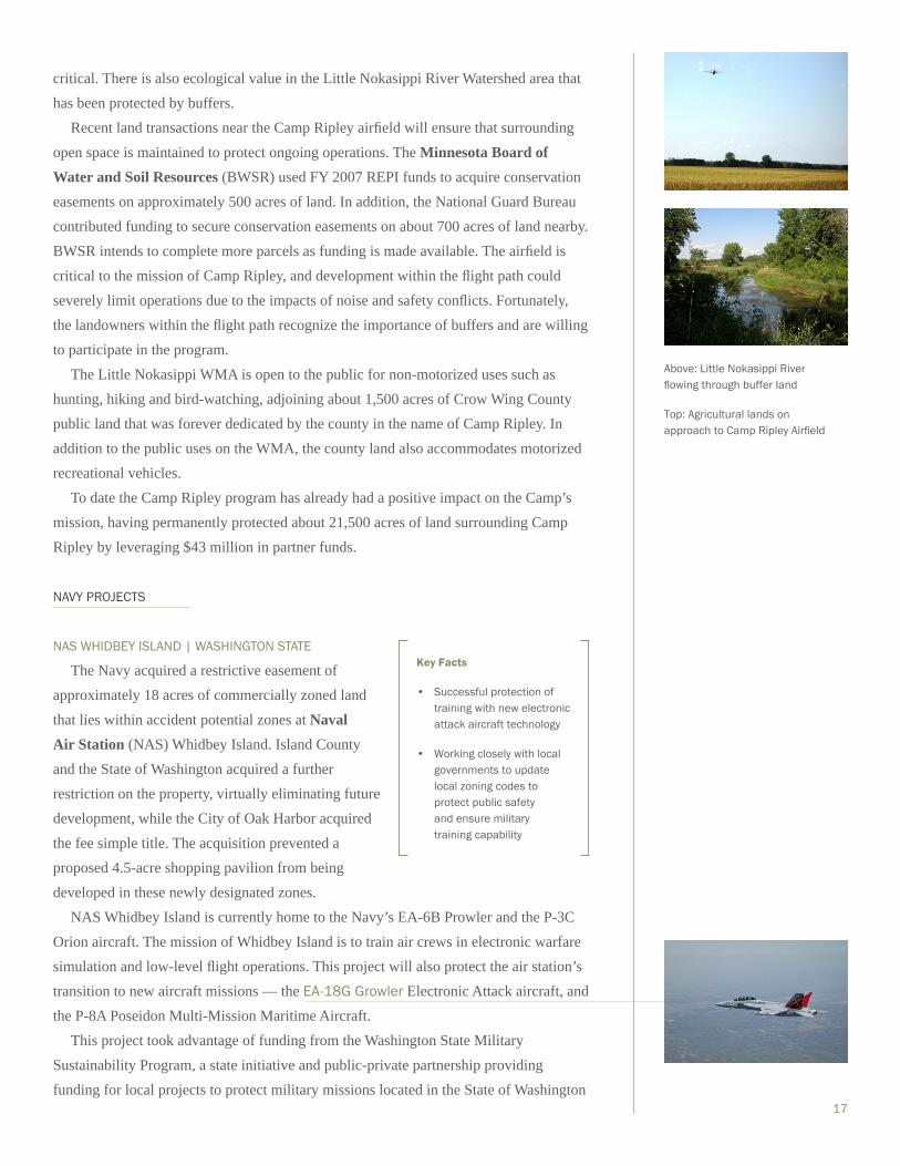
CAMP RIPLEY | MINNESOTA
Located in central Minnesota just west of a
wildlife management area (WMA) along the
Mississippi River, Camp Ripley is an important Army
National Guard range which supports maneuver
training, weapons familiarization, and aviation
gunnery and armor gunnery qualification. Since 9/11,
units from the Minnesota Army and Air National
Guard have served in 33 countries with a total
mobilization of over 17,000 Soldiers and Airmen.
The noise from Camp Ripley’s primary range complexes and unestablished artillery
firing points primarily impact lands to the east. Because the noise zones generated from
the established ranges extend into the Little Nokasippi WMA and surrounding lands,
implementing buffers that prevent incompatible development in these areas is extremely
Key Fact
Open space supports agriculture, forestry and water resources while ensuring continuity of military training that produces noise, dust, and smoke.
Key Facts
• Working with nearby landowners and the state natural resources board to secure noise impact areas for realistic training while protecting habitat
• Nearby wildlife area also open to public for recreational purposes
Camp Ripley Future Considerations
In addition to airfields (tactical, paved, and those for unmanned
aircraft), the REPI program will secure 63 independent
ranges that enable all Soldiers to achieve the maximum level
of readiness in the current operational environment.
On the forefront of improving and constructing ranges to enhance Soldier readiness, Camp Ripley
will construct seven new ranges totaling $60 million over the
next five years that will augment existing and future training opera-
tions. Currently, 162 interested landowners are awaiting participa-
tion in the Camp Ripley program, representing about 20,000
acres of land requiring about $19.7 million in REPI funding.
17
critical. There is also ecological value in the Little Nokasippi River Watershed area that
has been protected by buffers.
Recent land transactions near the Camp Ripley airfield will ensure that surrounding
open space is maintained to protect ongoing operations. The Minnesota Board of Water and Soil Resources (BWSR) used FY 2007 REPI funds to acquire conservation
easements on approximately 500 acres of land. In addition, the National Guard Bureau
contributed funding to secure conservation easements on about 700 acres of land nearby.
BWSR intends to complete more parcels as funding is made available. The airfield is
critical to the mission of Camp Ripley, and development within the flight path could
severely limit operations due to the impacts of noise and safety conflicts. Fortunately,
the landowners within the flight path recognize the importance of buffers and are willing
to participate in the program.
The Little Nokasippi WMA is open to the public for non-motorized uses such as
hunting, hiking and bird-watching, adjoining about 1,500 acres of Crow Wing County
public land that was forever dedicated by the county in the name of Camp Ripley. In
addition to the public uses on the WMA, the county land also accommodates motorized
recreational vehicles.
To date the Camp Ripley program has already had a positive impact on the Camp’s
mission, having permanently protected about 21,500 acres of land surrounding Camp
Ripley by leveraging $43 million in partner funds.
NAVY PROJECTS
NAS WHIDBEY ISLAND | WASHINGTON STATE
The Navy acquired a restrictive easement of
approximately 18 acres of commercially zoned land
that lies within accident potential zones at Naval Air Station (NAS) Whidbey Island. Island County
and the State of Washington acquired a further
restriction on the property, virtually eliminating future
development, while the City of Oak Harbor acquired
the fee simple title. The acquisition prevented a
proposed 4.5-acre shopping pavilion from being
developed in these newly designated zones.
NAS Whidbey Island is currently home to the Navy’s EA-6B Prowler and the P-3C
Orion aircraft. The mission of Whidbey Island is to train air crews in electronic warfare
simulation and low-level flight operations. This project will also protect the air station’s
transition to new aircraft missions — the EA-18G Growler Electronic Attack aircraft, and
the P-8A Poseidon Multi-Mission Maritime Aircraft.
This project took advantage of funding from the Washington State Military
Sustainability Program, a state initiative and public-private partnership providing
funding for local projects to protect military missions located in the State of Washington
Key Facts
• Successful protection of training with new electronic attack aircraft technology
• Working closely with local governments to update local zoning codes to protect public safety and ensure military training capability
Above: Little Nokasippi River flowing through buffer land
Top: Agricultural lands on approach to Camp Ripley Airfield
18
while balancing environmental concerns. The Navy worked closely with the local
government, who adopted new accident potential zones in the local zoning code.
This project is leading to multiple projects for FY09 in the same area to remove
commercial development threats to the mission.
NAES LAKEHURST | NEW JERSEY
The State of New Jersey’s Department of
Environmental Protection wanted to purchase about
250 acres of land just to the South of Naval Air Engineering Station (NAES) Lakehurst in order to
conserve the land and expand the Manchester Wildlife Management Area. Consistent
with Base Realignment and Closure (BRAC) recommendations, Fort Dix, McGuire
Air Force Base, and NAES Lakehurst form part of a three-base “megabase” with joint
training and operational capability.
The Manchester property included a cranberry bog, and its natural resources were
highly valued by the State. With the current owners looking to sell and the pressure for
development growing near the installation, this became a target of opportunity. For less
than 20% of the fee simple value ($1.8 million), the Navy was able to obtain permanent
protection south of the Station. DoD’s active role in this successful acquisition
demonstrated benefits to both parties.
Goodwill established in this transaction will help facilitate the partnership for the
larger and more complex land purchase of nearly 1,800 acres to the north of the Station
that, if developed, would be incompatible with the Navy’s and Air Force’s mission. New
Jersey and its counties are strong supporters of conservation, and each is well-funded
to preserve land. The Navy currently has an Encroachment Protection Agreement with
Ocean County and is pursuing buffering acquisitions.
MARINE CORPS PROJECTS
MCB CAMP LEJEUNE | NORTH CAROLINA (ALLEN TRACT)
The completion of the project at Marine Corps Base (MCB) Camp Lejeune is a tribute to
the perseverance and cooperative attitude of the
partners involved. The owner of the land wanted to ensure the land was protected from
development, but he had a unique approach to dealing with conservation agencies and
the military.
After long and complicated negotiations, the North Carolina Coastal Land Trust
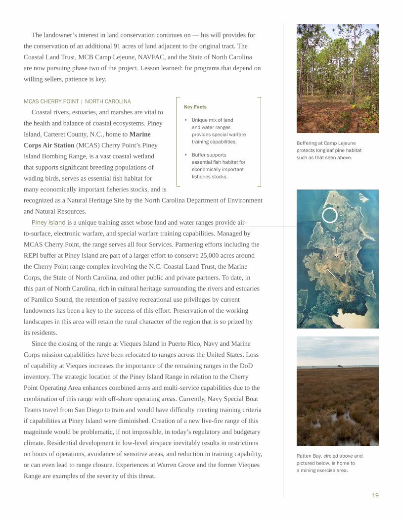
was able to conserve 148 acres of buffer land adjacent to maneuver and live-fire range
areas of Camp Lejeune. The area also possesses habitat suitable to support endangered
species.
Key Fact
Establishing a good working partnership may lead to future buffering opportunities.
Key Fact
Perseverance through difficult negotiations has its benefits.
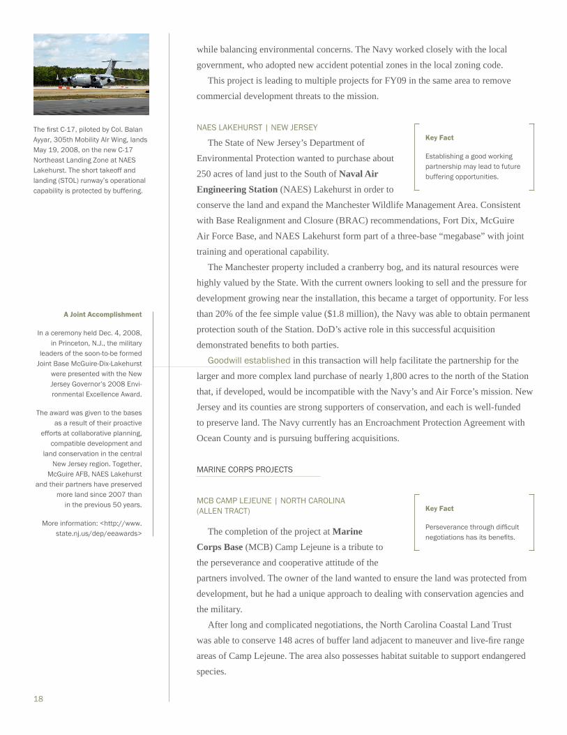
The first C-17, piloted by Col. Balan Ayyar, 305th Mobility AIr Wing, lands May 19, 2008, on the new C-17 Northeast Landing Zone at NAES Lakehurst. The short takeoff and landing (STOL) runway’s operational capability is protected by buffering.
A Joint Accomplishment
In a ceremony held Dec. 4, 2008, in Princeton, N.J., the military
leaders of the soon-to-be formed Joint Base McGuire-Dix-Lakehurst
were presented with the New Jersey Governor’s 2008 Envi-ronmental Excellence Award.
The award was given to the bases as a result of their proactive
efforts at collaborative planning, compatible development and
land conservation in the central New Jersey region. Together,
McGuire AFB, NAES Lakehurst and their partners have preserved
more land since 2007 than in the previous 50 years.
More information: <http://www.state.nj.us/dep/eeawards>
19
The landowner’s interest in land conservation continues on — his will provides for
the conservation of an additional 91 acres of land adjacent to the original tract. The
Coastal Land Trust, MCB Camp Lejeune, NAVFAC, and the State of North Carolina
are now pursuing phase two of the project. Lesson learned: for programs that depend on
willing sellers, patience is key.
MCAS CHERRY POINT | NORTH CAROLINA
Coastal rivers, estuaries, and marshes are vital to
the health and balance of coastal ecosystems. Piney
Island, Carteret County, N.C., home to Marine Corps Air Station (MCAS) Cherry Point’s Piney
Island Bombing Range, is a vast coastal wetland
that supports significant breeding populations of
wading birds, serves as essential fish habitat for
many economically important fisheries stocks, and is
recognized as a Natural Heritage Site by the North Carolina Department of Environment
and Natural Resources.
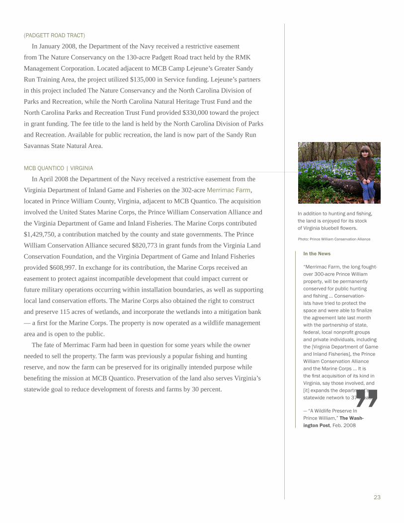
Piney Island is a unique training asset whose land and water ranges provide air-
to-surface, electronic warfare, and special warfare training capabilities. Managed by
MCAS Cherry Point, the range serves all four Services. Partnering efforts including the
REPI buffer at Piney Island are part of a larger effort to conserve 25,000 acres around
the Cherry Point range complex involving the N.C. Coastal Land Trust, the Marine
Corps, the State of North Carolina, and other public and private partners. To date, in
this part of North Carolina, rich in cultural heritage surrounding the rivers and estuaries
of Pamlico Sound, the retention of passive recreational use privileges by current
landowners has been a key to the success of this effort. Preservation of the working
landscapes in this area will retain the rural character of the region that is so prized by
its residents.
Since the closing of the range at Vieques Island in Puerto Rico, Navy and Marine
Corps mission capabilities have been relocated to ranges across the United States. Loss
of capability at Vieques increases the importance of the remaining ranges in the DoD
inventory. The strategic location of the Piney Island Range in relation to the Cherry
Point Operating Area enhances combined arms and multi-service capabilities due to the
combination of this range with off-shore operating areas. Currently, Navy Special Boat
Teams travel from San Diego to train and would have difficulty meeting training criteria
if capabilities at Piney Island were diminished. Creation of a new live-fire range of this
magnitude would be problematic, if not impossible, in today’s regulatory and budgetary
climate. Residential development in low-level airspace inevitably results in restrictions
on hours of operations, avoidance of sensitive areas, and reduction in training capability,
or can even lead to range closure. Experiences at Warren Grove and the former Vieques
Range are examples of the severity of this threat.
Key Facts
• Unique mix of land and water ranges provides special warfare training capabilities.
• Buffer supports essential fish habitat for economically important fisheries stocks.
Buffering at Camp Lejeune protects longleaf pine habitat such as that seen above.
Ratten Bay, circled above and pictured below, is home to a mining exercise area.

20
AIR FORCE PROJECT
WARREN GROVE PARTNERSHIP | NEW JERSEY
In addition to protecting the viability of continued
training missions, the project at Warren Grove Range
provides an opportunity to accommodate inertially
aided munitions and future weapon systems training
with buffer lands surrounding range property. Buffer
projects near the range are intended to manage the
amount of underbrush that grows on the forest floor.
Without buffer lands properly managed to address
this concern, the military mission at the range is
endangered due to the potential threat of wildfire. In
fact the range shut down entirely in May 2007 for
more than a year due in part to the excessive buildup
of dense underbrush, which directly contributed to
the severity of the wildfire there and the resultant
inability to control it. This is a prime example of how
a land management concern can also directly become a military readiness concern.
The project protects the Pinelands Federal Reserve, which consists of the rare
and sensitive upland pitch pine forest of the New Jersey Pine Barrens. This habitat is
historically fire-prone. The project permits the management of undergrowth to protect
this habitat from uncontrolled wildfire danger. The project protects over 80 federally
and state-listed threatened, endangered, and special concern animal species and over 20
vegetative species as identified in the December 2006 Warren Grove Range Integrated
Natural Resource Management Plan. Species of note include the Bald eagle, Bog turtle,
and Helonias bullata (Swamp Pink, an herb), as well as the state-listed Northern Pine
snake, Timber rattlesnake, Barred owl, Pine Barrens treefrog, and many other species of
state-listed endangered birds with breeding populations.
The Warren Grove Partnership supports FY08 NDAA Section 359 (Reports On
Safety Measures And Encroachment Issues And Master Plan For Warren Grove Gunnery
Range, New Jersey). Under House Report 110-447, Congress established reporting
requirements for the Secretary of the Air Force to submit to Congress reports detailing
measures taken to ensure safety and mitigate encroachment at Warren Grove Range. Part
(b) of Section 359 requires the SAF to submit to Congressional committees a master
plan for Warren Grove Range. The Master Plan was to include measures to mitigate
encroachment of the Range, taking into consideration military mission requirements,
land use plans, surrounding community, economy of the region, and protection of the
environment and public health, safety, and welfare. This project is instrumental in
meeting the Range’s Master Plan objectives required by the NDAA outlined above.
Key Facts
• Buffer projects near Warren Grove focus on preventing wildfires.
• Wildfire prevention involves managing forest under-growth that if allowed to grow out of control makes wildfires stronger and harder to contain.
• While promoting military readiness, wildfire prevention also benefits nearby species.
• Warren Grove was closed for more than a year following a forest fire in May 2007.
Wildfires reduce visibility, inhib-iting military readiness.
Photos: J. Douglas Ripley

21
02-4 | SERVICE-FUNDED PROJECTS
Many projects are undertaken at the initiative of the various Services invoking 10
U.S.C. § 2684a authority but not requesting REPI funding (see Figure 1-1, p. 3). These
are projects that the Services consider so important to their readiness, they are willing to
execute their own funds to ensure the project is completed. In addition to funding their
own projects, the Services may also choose to add their own funding to REPI projects
beyond what DoD provides.
ARMY PROJECTS
From FY07 to the present, 28 non-REPI-funded Army projects have closed
at seven installations under 10 U.S.C. §2684a authority. Consistent with program
objectives, these projects protect land from development that is incompatible with the
military mission. The parcels’ total cost was approximately $23 million, paid for on a
parcel-by-parcel basis with combined Army and partner funding. Using $1.7 million
in Army funds, for example, eleven parcels buffer Fort Bragg training activities while
preserving valuable Red-cockaded woodpecker habitat.
Consisting of 1,484 acres, the Camp Blanding (Fla.) project’s parcel was purchased
in September 2007 by the Florida Department of Environmental Protection for a total of
nearly $6.4 million. The parcel, located directly within the ACUB priority area adjacent
to the installation’s eastern boundary, will help alleviate residential encroachment
issues and will be managed for Endangered Species Act-protected species as well as the
protection of valuable watersheds.
Also worth noting is the FY07 parcel closing near U.S. Army Garrison–Hawaii on the island of Oahu. The 3,716-acre parcel, which buffers training activities at the
installation, provides valuable habitat for the endangered Elepaio bird. The Trust
for Public Land acquired the parcel at a total cost of $5.5 million, with the Army
contributing $900,000.
CAMP SAN LUIS OBISPO | CALIFORNIA
The Camp San Luis Obispo ACUB program received $350,000 from the National
Guard Bureau, which was directed to a partner agency, the Land Conservancy of
San Luis Obispo, through a cooperative agreement. A draft conservation easement is
currently under development for the 880-acre Glick Ranch, identified in the camp’s
ACUB program as a priority property. This property compliments the original purchase
executed with FY06 REPI funds, and together these properties will provide a buffer
against development along the eastern installation boundary. As a result, training
areas X-Ray and Whiskey consisting of approximately 1,650 acres will continue to be
used to their full capacity. These upland training areas are unique and used regularly
for valuable truck driver/convoy instruction and dismounted exercises. In addition
to protecting the camp’s training site mission, these easements ensure future training

22
opportunities for the California Army National Guard as well as other federal, state, and
local agencies.
From the partner’s perspective, the properties add to the City of San Luis Obispo’s
Greenbelt Protection Program, preserving open space as well as the flora and fauna
associated with native California chaparral and coastal shrub communities. The Glick
Ranch conservation easement is valued at $1 million, with $350,000 from NGB,
$500,000 from the City of San Luis Obispo and $150,000 provided by the landowner as
a charitable donation.
NAVY PROJECTS
Since FY 2007, the Navy has added additional Service funding to three long-term
encroachment partnering agreements to augment OSD’s REPI funding including:
• NAS FALLON, NEVADA | The Navy added $1 million to its agreement
with two NGOs (Nevada Land Conservancy and Lahontan Valley
Land and Water Alliance) to acquire interests in land primarily
within the Navy’s noise contours and accident potential zones.
• NAS OCEANA, VIRGINIA | The Navy added $322,000 to the
agreement with the City of Virginia Beach to limit development
in the inter-facility traffic area between NAS Oceana and Navy’s
Outlying Landing Field Fentress in the City of Chesapeake.
• NAS WHITING FIELD, FLORIDA | The Navy added $2 million to its
agreement with Santa Rosa County to protect lands within the overflight
areas and accident potential zones surrounding NAS Whiting Field.
MARINE CORPS PROJECTS
MCB CAMP LEJEUNE | NORTH CAROLINA (KASAAB TRACT)
In September 2007, the Department of the Navy received a restrictive easement from
The Nature Conservancy on the 55.17-acre Kasaab Tract, the fourth project there to
be completed using § 2684a authority. The Nature Conservancy utilized $375,000 of
Service funding and was matched by a grant to the North Carolina Wildlife Resources
Commission from the North Carolina Natural Heritage Trust Fund. The fee title to the
land is held by the commission. The land is now part of the Stones Creek Game Lands
and is available for public recreation.Land around Camp Lejeune is home to various rare plant species, such as the Yellow pitcherplant seen here.
Photo: Melissa McGaw
In the News
“‘We enjoy a tremendous partnership with the state and it is important that we manage the growth around Whiting Field,’ said Capt. Enrique ‘Rick’ Sadsad, commanding officer, Naval Air Station Whiting Field. ‘We look forward to this partner-ship and future partnerships that help preserve habitat and reduce encroachment on military operations.’”
— “Land Deal to Protect Coldwater Creek,” Pensacola (Fla.) News Journal, Dec. 2008
“A bit of ranching history has been preserved in Churchill County with the permanent protection of the Cushman-Corkill Ranch in Fallon … ‘By contributing funds to purchase a restrictive use easement on this property, the Navy is helping to protect the agricultural and historical values that have contributed so much to Fallon’s heritage and frontier spirit.’”
— “Centennial Ranch in Fallon Protected by Nevada Land Conservancy with Conservation Easement,” Lahontan (Nev.) Valley News, Aug. 2008
”
”
23
(PADGETT ROAD TRACT)
In January 2008, the Department of the Navy received a restrictive easement
from The Nature Conservancy on the 130-acre Padgett Road tract held by the RMK
Management Corporation. Located adjacent to MCB Camp Lejeune’s Greater Sandy
Run Training Area, the project utilized $135,000 in Service funding. Lejeune’s partners
in this project included The Nature Conservancy and the North Carolina Division of
Parks and Recreation, while the North Carolina Natural Heritage Trust Fund and the
North Carolina Parks and Recreation Trust Fund provided $330,000 toward the project
in grant funding. The fee title to the land is held by the North Carolina Division of Parks
and Recreation. Available for public recreation, the land is now part of the Sandy Run
Savannas State Natural Area.
MCB QUANTICO | VIRGINIA
In April 2008 the Department of the Navy received a restrictive easement from the
Virginia Department of Inland Game and Fisheries on the 302-acre Merrimac Farm,
located in Prince William County, Virginia, adjacent to MCB Quantico. The acquisition
involved the United States Marine Corps, the Prince William Conservation Alliance and
the Virginia Department of Game and Inland Fisheries. The Marine Corps contributed
$1,429,750, a contribution matched by the county and state governments. The Prince
William Conservation Alliance secured $820,773 in grant funds from the Virginia Land
Conservation Foundation, and the Virginia Department of Game and Inland Fisheries
provided $608,997. In exchange for its contribution, the Marine Corps received an
easement to protect against incompatible development that could impact current or
future military operations occurring within installation boundaries, as well as supporting
local land conservation efforts. The Marine Corps also obtained the right to construct
and preserve 115 acres of wetlands, and incorporate the wetlands into a mitigation bank
— a first for the Marine Corps. The property is now operated as a wildlife management
area and is open to the public.
The fate of Merrimac Farm had been in question for some years while the owner
needed to sell the property. The farm was previously a popular fishing and hunting
reserve, and now the farm can be preserved for its originally intended purpose while
benefiting the mission at MCB Quantico. Preservation of the land also serves Virginia’s
statewide goal to reduce development of forests and farms by 30 percent.
In addition to hunting and fishing, the land is enjoyed for its stock of Virginia bluebell flowers.
Photo: Prince William Conservation Alliance
In the News
“Merrimac Farm, the long fought-over 300-acre Prince William property, will be permanently conserved for public hunting and fishing … Conservation-ists have tried to protect the space and were able to finalize the agreement late last month with the partnership of state, federal, local nonprofit groups and private individuals, including the [Virginia Department of Game and Inland Fisheries], the Prince William Conservation Alliance and the Marine Corps … It is the first acquisition of its kind in Virginia, say those involved, and [it] expands the department’s statewide network to 37 areas.”
— “A Wildlife Preserve In Prince William,” The Wash-ington Post, Feb. 2008”

24
02-5 | CUMULATIVE PROJECTS: FY05-09
As seen in Figure 2-2 below, between fiscal years 2005 and 2009, REPI funding
supported projects at 53 installations and ranges in 23 states across the country.
FY05 or FY06 Projects
FY07 Projects
FY08 or FY09 Projects
CUMULATIVE REPI-FUNDED PROJECTS: FY05-09 Figure 2-2

03-1 | SUPPORTIVE EFFORTS
DoD oversees and administers REPI and 10 U.S.C. § 2684a in conjunction
with other supportive and complementary initiatives that in unison serve to advance
DoD’s compatible land use and outreach efforts. Policy and tool development,
planning and execution of local, state, regional and national-level partnering,
and stakeholder involvement and outreach are all essential underpinnings for a
successful REPI program and implementation of 10 U.S.C. § 2684a. A robust REPI
program generates goodwill with key partners and enables effective sustainable
ranges outreach, thereby enhancing DoD’s ability to sustain military training and
testing activities. As previously noted, these efforts are referred to collectively as the
Sustainable Ranges Initiative (SRI).
To advance this broader framework, DoD is institutionalizing effective local, state,
and regional collaboration and planning, while fostering productive relationships with
key stakeholders who have interests in lands around bases and ranges. By providing
installation-level personnel with the appropriate policy, training, and tools needed to
work collaboratively with those outside the installation fence line, DoD is fostering
compatible land use planning. By providing outside stakeholders with an improved
understanding of military readiness needs as well as available cooperative planning
processes and tools, DoD is opening up new partnership opportunities.
Information sharing between DoD and its partners and the pursuit of specific
collaborative planning projects present valuable opportunities to further the goals of
REPI. DoD’s Sustainable Ranges Initiative public Web site at <http://www.denix.osd.
mil/sustainableranges> helps increase public awareness of the program, while news
articles also reflect a growing interest in the program.
INTEGRATION AND INSTITUTIONALIZATION03

26
OUTREACH
Enhancing public outreach and improving collaboration and partnering at all
levels are critical to the success of DoD’s mission sustainment efforts. For additional
information on Sustainable Ranges Initiative efforts, please see the Sustainable Ranges
Report to Congress.
Outreach and stakeholder involvement efforts provide a fundamental basis for
strong REPI partnerships. Direct engagement with interested stakeholders through
partnerships and dialogue form part of a robust outreach initiative. To enhance these
efforts, the program draws on broader DoD Sustainable Ranges Initiative outreach
activities. These include extensive efforts at information exchange through a variety of
printed and electronic media and formats (including a series of informational “primers”
about various aspects of partnering efforts), range tours to provide stakeholders with
firsthand knowledge of the military mission, investment in research and education
concerning DoD’s mission sustainment needs, and participation in partner conferences
and events. DoD’s overall outreach approach is depicted in Figure 3-1 below.
PARTNERSHIPS
FEDERAL AGENCIES
The REPI program and broader Sustainable Ranges Initiative are aggressively
developing partnerships with federal agencies through many different avenues. Active
engagement with similar funding programs through the Federal Land Protection
Programs Working Group provides a forum for discussion of common issues and
solutions, and insight into how programs can work together to provide multiple
benefits to communities. The Federal Green Infrastructure Community of Practice
provides similar opportunities in an expanded venue with multiple regulatory and land
management agencies. Expanded use of Memoranda of Understanding (MOUs) and
interagency agreements offers an excellent way for DoD to tap into the expertise of our
Sustainable Ranges Outreach
Internal Education External Education Coalitions and Partnering
• Build key coalitions in support of DoD Sustainable Ranges Initiative
• Create sustainable partnerships to implement projects
• Educate public and stakeholders on military readiness needs
• Promote awareness through media coverage
• Educate Service personnel on Sustainable Ranges Initiative
OUTREACH APPROACH Figure 3-1

27
sister agencies through sharing personnel, such as the second year of a successful detail
from the National Park Service.
LOCAL, STATE AND REGIONAL GOVERNMENTS
While national-level partnerships can produce top-level policy solutions, more
targeted partnering is needed to address specific problems or implement solutions at
a state or multi-state level. DoD is therefore encouraging the development of regional
partnerships among state, county and local governments in areas where DoD has
significant training and testing activities, such as in the Southeast and Southwest, two of
the fastest-growing regions of the U.S. These partnerships support multi-jurisdictional
collaboration on planning and land-use issues from a broader perspective, enhancing
range sustainment and preventing incompatible land use around military installations.
The Southeast Regional Partnership for Planning and Sustainability (SERPPAS)
brings together senior leadership from southeastern states (currently Alabama, Florida,
Georgia, North Carolina, and South Carolina) and federal agencies to work collectively
on regional planning, conservation, economic, and sustainability issues. SERPPAS
leverages its members’ problem solving and encroachment prevention efforts, providing
mutual benefits to its many partners. In particular, this effort works to promote improved
regional, state and local coordination to identify and address shared land use and
mission accomplishment issues in the region. SERPPAS is carrying out a number of
trainings, workshops, and collaborative land management projects throughout the
Southeast.
Beginning to emerge from its formative stages, the Western Regional Partnership
(WRP) continues to advance toward the eventual goal of bringing a robust partnership
to the Southwest bearing similarities to the benefits reaped by the SERPPAS approach.
This partnership brings together DoD, federal and state agencies, tribal entities, and
NGO stakeholders to identify and address regional issues of mutual concern, and to
advance shared strategic planning, land management and policy goals. Partnership
workgroup topics include land use, wildlife corridors, alternative energy, land
management, and disaster preparedness. These workgroups bring stakeholders together
around common interests, providing a needed mechanism to address these emerging
challenges. A successful WRP will contribute to the sustainment of test and training in
the rapidly growing western region of the country.
Ensuring the success of these two regional efforts is critical to DoD’s future plans
to institutionalize effective state, local, and regional collaboration and planning. Existing
military Commanders’ Councils in Arizona, Nevada, and North Carolina have proven
very valuable, allowing DoD to more fully present its overall land, air and sea space
requirements and provide a more unified voice in regional partnering. These bodies will
serve as analogs to state military planning commissions, and provide communications
venues for state and regional agencies to discuss broad issues with key DoD leaders.
They will also become conduits of information concerning state economic development,

28
environmental, transportation, and other policy and planning efforts that inform
installation plans for mission growth and protection.
NONGOVERNMENTAL ORGANIZATIONS (NGOs)
NGO support is a fundamental building block of the program’s success. The Land
Trust Alliance, The Trust for Public Land, The Nature Conservancy, International City/
County Management Association, the Conservation Fund, National Association of
Counties, American Farmland Trust and other national groups contribute to the effort
through development of outreach pieces such as primers, support and participation in
regional partnering efforts, and on-the-ground conservation projects. Equally important,
many regional and local groups are in the lead in resource conservation and compatible
land use projects. Land Legacy in Oklahoma, Oahu Conservation Partnership in Hawaii,
Kansas Land Trust, North Carolina Coastal Land Trust, Sandhills Area Land Trust in
North Carolina, and the Georgia Land Trust are just of few of the vital partners who turn
program funding into both protection of the DoD mission and conservation successes for
their communities. REPI and the Services reach out to a multitude of stakeholders and
interest groups through participation in events like the annual Land Trust Alliance Rally,
building partnerships that provide broad-based benefits to the Services, communities,
and the environment.
EXAMPLES OF OUTREACH
LMI PARTNER SURVEY | In the spring of 2008, LMI Government Consulting conducted
a survey designed to assess partner understanding of the REPI program and satisfaction
with Service-specific buffer program implementation. Results were positive, with 81
percent of partners reporting program satisfaction, and more than half reporting an
improved opinion of military conservation interests. Partners cited a shared conservation
interest in buffer lands and support for the military’s conservation efforts as primary
motivating factors for entering into partnerships with the Services.
Using the survey results, OSD is developing a manual for NGOs and local
governments on how to partner with DoD entitled “DoD Conservation Partnerships to
Support Military Training and Testing: A Manual for Partnering with the Military,” the
ninth in a series of primers developed by OSD to enhance partnership opportunities for
partners and installations alike by promoting best practices and improving knowledge-
sharing. This primer was the first to follow a specific survey process to identify areas of
potential misunderstanding and clarify the procedures used among the various Services.
LAND TRUST ALLIANCE TRAINING | OSD hosted a first-of-its-kind event at the 2008
Land Trust Alliance Rally, the National Conservation Conference, in Pittsburgh,
Pennsylvania. Introducing the concept of the “webinar” for the first time to Rally
participants, OSD leveraged a well-attended half-day seminar to provide training to
land trusts and local governments on how to partner with DoD to accomplish buffering.
Seventy-five additional participants joined in from across the country via the Internet

29
in a lively exchange of ideas, tips, and knowledge. OSD is now working with LTA to
leverage the success of that one-time event into an ongoing knowledge exchange.
OTHER TOOLS
Under Title 10 of the United States Code, the Services are responsible for
training and equipping forces as well as maintaining installations and ranges (see
Service Approaches, Section 1). DoD Directive 3200.15 establishes policy and assigns
responsibility given under Title 10 with regard to sustainment of test and training
ranges and operating areas. Other related DoD directives and instructions address noise
management; Air Installation Compatible Use Zones (AICUZ); the Joint Land Use
Studies (JLUS) program; the use, management, assessment, and overall clearance of
operational ranges; and the environmental and safety concerns of explosive hazards.
DoD is also currently developing both an outreach and an overseas sustainment
instruction, both to be deployed in late FY 2009.
The Services also develop their own policy directives and guidance on the
sustainment of ranges and training areas within the general framework of the
Sustainable Ranges Initiative. The Service approaches are defined by their overall
strategy, current and future requirements, data collection and management systems,
assessment tools and quantification of encroachment impacts, and documentation and
implementation plans.
In the range sustainment effort, DoD deploys a number of tools, including the
following:
• AIR INSTALLATION COMPATIBLE USE ZONE (AICUZ) AND RANGE AIR INSTALLATION
COMPATIBLE USE ZONE (RAICUZ) | The military works with local governments
and the community using zoning and local ordinances to reduce potential
accidents and noise impacts to the community near airfields. The RAICUZ
program specifically addresses range safety issues at air-to-ground ranges.
• JOINT LAND USE STUDY (JLUS) | Funded by the Office of Economic
Adjustment, this program enables DoD to work with local government
and the community to develop plans and guidelines for compatible land
uses around installations, while promoting economic development.
• INTEGRATED NATURAL RESOURCE MANAGEMENT PLAN (INRMP) |
Installations work with federal and state agencies to develop natural
resources management plans that support mission requirements.
The authority provided by 10 U.S.C. §2684a, however, remains the most flexible
tool, allowing the most immediate encroachment threats to be addressed.

30
03-2 | PROGRAM OVERSIGHT
OSD works collectively with the Services to coordinate REPI policy and
implementation through a focused REPI Interservice Working Group (ISWG). This
group pulls together and draws upon the expertise of the Services and OSD. The REPI
ISWG meets regularly to track Program progress, discuss projects, and raise key issues
for resolution. This group also actively supports the annual REPI project submission,
review and allocation process, and assists in the development of the Annual Report to
Congress. In addition to the REPI ISWG, a Legal Working Group led by the OSD Office
of General Counsel convenes counsels from the Military Departments on a semiannual
basis to provide a forum for legal interpretation, clarification and discussion of issues.
Through this collective effort, the REPI Team reviews and refines further guidance
for the REPI Program Guide that sets out the policies and procedures for the Program.
A key component of REPI oversight, the Guide outlines to Services and installations
the steps for requesting funding for a REPI project as well as the Program requirements
set out by 10 U.S.C. § 2684a authority and OSD policy. The REPI Program Guide
continues to be an important tool for ensuring a smooth and successful process of REPI
proposal submission, selection, and implementation.
INTERNAL PROGRAM MANAGEMENT
OSD provides REPI program oversight, manages REPI funding allocation, and
monitors REPI project execution. It also ensures communication and coordination
between REPI and the rest of the SRI and other encroachment prevention programs
(see figure below). An area of emphasis is the development of outcome-based protocols
for identifying and communicating both the need for the program and the success
REPI PROGRAM MANAGEMENT
AND OVERSIGHT
REPI Interservice Working GroupREPI Program Team
OSD, Contract SupportServices
Army, Navy,Marine Corps, Air Force
Sustainable Ranges
Integrated Product Teams
Land Use Interservice
Working Group
(IPTs)
OVERSIGHT STRUCTURE Figure 3-2
Chain of Command
The Overarching Integrated and Working Integrated Product
Teams (OIPT and WIPT) of the SRI report to the Senior Readiness
Oversight Council (SROC), which includes the Joint Chiefs of
Staff and Undersecretaries of Defense, who in turn report to the Secretary of Defense (SecDef) on
matters pertaining to readiness.
The OIPT coordinating body for all issues of encroachment includes
members from all four Services and is chaired by the Deputy
Undersecretary of Defense for Readiness (DUSD-R); the Deputy
Undersecretary of Defense for Installations & Environment
(DUSD-I&E); and Deputy Director, Operational Test and Evalua-
tion for Live Fire Test (DDOT&E-LFT). The WIPT implements the recommendations of the OIPT.
In short: SecDef ➔ SROC ➔ OIPT ➔ WIPT

31
of projects authorized under 10 U.S.C. § 2684a. RAND Corporation is currently
conducting a survey of such protocols nationally, and OSD is working with similar
federal programs to glean lessons that can be learned from those protocols’
longer histories.
PROJECT MANAGEMENT
As described in last year’s Report to Congress, OSD and the Services continue
to refine the process for selecting projects. This process includes the submission of
proposals by the Services and the application of tailored criteria that are used to score
those projects. OSD worked with the Services throughout 2008 to build on this approach
and further adjust the criteria and process used in FY09. OSD continues to work with
the Services to refine guidance for FY10 and beyond.
Particular refinements include adding effective scoring measures and elevating the
importance given to the threat posed by encroachment to military testing, training, and
operations at the particular project installation. The general criteria used in evaluating
proposals include the following:
• Threat to military training, testing, and operations;
• Benefit to DoD partners and the surrounding civilian community;
• Viability of the agreement/project; and
• Benefit of the project to multiple Services.
The key elements in the process are:
OSD SOLICITATION TO SERVICES AND SERVICE SUBMITTAL OF PROPOSALS TO OSD
OSD provides the Services with a detailed explanation that establishes the criteria
used for selecting the projects and issues a memorandum soliciting project proposals
based on Service priorities that address these criteria. OSD also provides consultation
and training support to the Services to aid in understanding of the guidance and improve
the quality of project proposals. The Services then develop and submit their annual
REPI project proposals. Each Service, as described in last year’s Report to Congress,
has its own internal process for choosing its proposals. For Fiscal Year 2009, based on
Service feedback, more time was given to the Services to submit their proposals.
PROPOSAL SCORING AND OSD/SERVICES MEET TO REVIEW THE SERVICE SCORES PROVIDED
Upon receipt of the project proposals from the Services, OSD distributes the
proposals to the Services for scoring against the criteria developed. OSD also scores
all proposals internally. The Services then score the proposals (except their own) and
meet together with OSD to discuss the scores on a point-by-point basis and to add new

32
information about the projects or correct any misimpressions; the scores can thus be
adjusted through this input.
BASED ON REVISED SCORES, PROPOSAL RANKING DEVELOPED WITH OSD/SERVICE JOINT REVIEW
OSD provides the list of scored proposals to the Services and allows the Services
to review the draft ranking list and to provide the Services an opportunity for feedback
with respect to the inclusion of any of their specific project proposals. This provides
a final opportunity for Service leadership to express the impacts of policy, Base
Realignment and Closure, force growth and restructuring, and other factors on the
readiness and vulnerability to encroachment of installations.
REPI PROJECT PROPOSAL SELECTION COMMITTEE RECOMMENDATIONS
A final ranked list of recommended DoD REPI proposed projects is provided to the
OSD leadership for final approval and allocation based on appropriated funds.
ANNUAL PROCESS EVALUATION
As part of the process, OSD works with the Services each year to learn lessons and
improve upon the process. The process is continuously improved as REPI matures.
WEB-BASED DATABASE DEVELOPMENT
As a step toward further institutionalizing REPI and enhancing the tracking and
maintenance of REPI project data, the REPI Team is developing an internally accessible
Web database. The objective of the database is to provide a central repository for all
10 U.S.C. § 2684a project-related information. Such information includes fiscal year
REPI funds utilized, obligation and execution of REPI funds, Service funds contributed,
partner funds contributed, acreage, planned project acquisition and objectives and actual
implemented acquisition details. The database will allow REPI and Service managers
to access up-to-date project details, and to generate a variety of reports. The first two
phases of the database are planned in FY09, and further refinements and capabilities are
being added as additional development phases proceed.
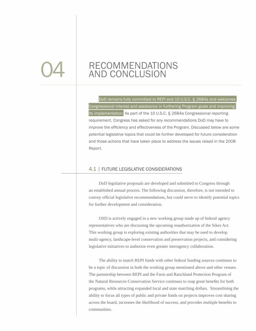
DoD remains fully committed to REPI and 10 U.S.C. § 2684a and welcomes
Congressional interest and assistance in furthering Program goals and improving
its implementation. As part of the 10 U.S.C. § 2684a Congressional reporting
requirement, Congress has asked for any recommendations DoD may have to
improve the efficiency and effectiveness of the Program. Discussed below are some
potential legislative topics that could be further developed for future consideration
and those actions that have taken place to address the issues raised in the 2008
Report.
4.1 | FUTURE LEGISLATIVE CONSIDERATIONS
DoD legislative proposals are developed and submitted to Congress through
an established annual process. The following discussion, therefore, is not intended to
convey official legislative recommendations, but could serve to identify potential topics
for further development and consideration.
OSD is actively engaged in a new working group made up of federal agency
representatives who are discussing the upcoming reauthorization of the Sikes Act.
This working group is exploring existing authorities that may be used to develop
multi-agency, landscape-level conservation and preservation projects, and considering
legislative initiatives to authorize even greater interagency collaboration.
The ability to match REPI funds with other federal funding sources continues to
be a topic of discussion in both the working group mentioned above and other venues.
The partnership between REPI and the Farm and Ranchland Protection Program of
the Natural Resources Conservation Service continues to reap great benefits for both
programs, while attracting expanded local and state matching dollars. Streamlining the
ability to focus all types of public and private funds on projects improves cost sharing
across the board, increases the likelihood of success, and provides multiple benefits to
communities.
RECOMMENDATIONS AND CONCLUSION04
34
In light of its growing REPI experience, DoD continues to evaluate these and other
prospective legislative or administrative initiatives and may develop new legislative
proposals as part of the FY 2010 or later NDAA legislative processes. In addition to the
tools described on p. 29, DoD advocates the development of a full range of tools to help
Services meet the encroachment threat.
4.2 | CONCLUSION
The Congressional authority granted by 10 U.S.C. § 2684a is a critical tool for
DoD and its partners in the ongoing effort to mitigate the effects of encroachment on
testing, training, and operations. Concurrently, REPI remains a highly effective funding
source to implement this tool. Through the end of FY 2008, 37 military installations and
ranges in 23 states participated in the REPI program, putting in place permanent land
use protections that will provide a long-term benefit to military readiness. The flexibility
§ 2684a authority provides is particularly useful in unexpected situations where other
tools or strategies (see Section 3.1.3) cannot fully provide the necessary protection for
the mission.
These same tools help DoD’s neighbors, addressing important partner objectives
related to habitat conservation, biodiversity and open space preservation, community
land use planning, and economic development. Increasingly, REPI is attracting wide
interest from other federal agencies, states, localities and NGOs. This interest is helping
the Services establish new and beneficial relationships with others who share common
land management interests and can help to preserve military readiness while also
furthering their own goals.

10 U.S.C. § 2684a (g) LANGUAGE
No later than March 1, 2007, and annually thereafter, the Secretary of Defense
shall, in coordination with the Secretaries of the military departments and the Director
of the Department of Defense, Test Resource and Management Center, submit to the
Committees on Armed Services of the Senate and House of Representatives a report on
the projects undertaken under agreements under this section.
Each report under paragraph (1) shall include the following:
• A description of the status of the projects undertaken under this section
• An assessment of the effectiveness of such projects, and other
actions taken pursuant to this section, as part of a long-term
strategy to ensure the sustainability of military test and training
ranges, military installations, and associated airspace.
• An evaluation of the methodology and criteria used to select, and to establish
priorities for, projects undertaken under agreements under this section.
• A description of any sharing of costs by the United States and eligible
entities under subsection (d) during the preceding year, including
a description of each agreement under this section providing for
the sharing of such costs and a statement of the eligible entity or
entities with which the United States is sharing such costs.
APPENDIX A:
LEGISLATIVE REPORTING REQUIREMENTSA