WARRIEWOOD VALLEY STRATEGIC REVIEW
81
www.pittwater.nsw.gov.au Warriewood Valley Strategic Review Addendum Report ADOPTED 17 NOVEMBER 2014 Warriewood V Add
Transcript of WARRIEWOOD VALLEY STRATEGIC REVIEW

www.pittwater.nsw.gov.au
Warriewood Valley Strategic ReviewAddendum Report
ADOPTED 17 NOVEMBER 2014
Warriewood VAdd

WARRIEWOOD VALLEY STRATEGIC REVIEW ADDENDUM REPORT
WARRIEWOOD VALLEY STRATEGIC REVIEW ADDENDUM REPORT 2014
Amendment no.
Date Description Status
1 28 May 2014 Draft Warriewood Valley Strategic Review Addendum Report presented to Council on 2 June 2014 for public exhibition Draft
2 4 June 2014
Draft Warriewood Valley Strategic Review Addendum Report endorsed by Council on 2 June 2014 for public exhibition. Amended consistent with Council resolution of 2 June 2104 to correct typographical/mapping errors.
Exhibited Draft
3 11 November 2014
Draft Warriewood Valley Strategic Review Addendum Report amended post exhibition. Presented to Council on 17 November 2014 for adoption. Final Draft
4 17 November 2014
Warriewood Valley Strategic Review Addendum Report adopted by Council at meeting held on 17 November 2014. Adopted by Council

WARRIEWOOD VALLEY STRATEGIC REVIEW ADDENDUM REPORT TABLE OF CONTENTS
i
TABLE OF CONTENTS
1.0 EXECUTIVE SUMMARY ............................................................................................................................. 2
1.1 BACKGROUND AND PURPOSE ................................................................................................................ 2 1.2 THE REVIEW PROCESS .......................................................................................................................... 2 1.3 RECOMMENDATIONS ............................................................................................................................. 4 1.4 PROVISION OF INFRASTRUCTURE AND SERVICES .................................................................................... 4 1.5 CONCLUSION ........................................................................................................................................ 5
2.0 WHY ARE WE UNDERTAKING THE WARRIEWOOD VALLEY STRATEGIC REVIEW ADDENDUM REPORT? ........................................................................................................................................................ 12
2.1 COMPLETION OF WARRIEWOOD VALLEY STRATEGIC REVIEW REPORT 2012 ......................................... 12 2.2 REVIEW OF OTHER PITTWATER-WIDE POLICIES AND STUDIES SINCE THE COMPLETION OF THE 2012
STRATEGIC REVIEW ............................................................................................................................ 20 2.3 MOVING FROM THE WARRIEWOOD VALLEY PLANNING FRAMEWORK 2010 ............................................. 21 2.4 WARRIEWOOD VALLEY SECTION 94 CONTRIBUTIONS PLAN................................................................... 21 2.5 FORWARD PATH ................................................................................................................................. 22
3.0 THE REVIEW PROCESS .......................................................................................................................... 24
3.1 IDENTIFYING THE LAND TO BE REVIEWED .............................................................................................. 24 3.2 FACTORS CONSIDERED DURING THE OPPORTUNITIES AND CONSTRAINTS ANALYSIS ................................ 25 3.3 PROCESS FOR ASSESSING ENVIRONMENTAL AFFECTATIONS .................................................................. 26 3.4 COMMUNITY ENGAGEMENT PROCESS ................................................................................................... 28 3.5 PROBITY ADVISOR .............................................................................................................................. 28
4.0 RESULTS .................................................................................................................................................. 30
4.1 SUMMARY OF RESULTS ....................................................................................................................... 30 4.2 UNDEVELOPED SECTORS WITH LIMITED CAPACITY FOR DEVELOPMENT ................................................... 31 4.3 RESIDENTIAL SECTORS WITH DEVELOPMENT POTENTIAL AND/OR REQUIRING CLARIFICATION ................... 33 4.4 SOUTHERN BUFFER AND SECTORS 172, 173 AND 174 ......................................................................... 36 4.5 OTHER EMPLOYMENT GENERATING SECTORS ....................................................................................... 38
5.0 RECOMMENDATIONS ............................................................................................................................. 42
5.1 INTRODUCTION ................................................................................................................................... 42 5.2 RECOMMENDATIONS FOR RESIDENTIAL SECTORS ................................................................................. 42 5.3 RECOMMENDATIONS FOR THE SOUTHERN BUFFER AND SECTORS 172, 173 AND 174 ............................ 47 5.4 RECOMMENDATIONS FOR OTHER EMPLOYMENT GENERATING/INDUSTRIAL SECTORS ............................... 49 5.5 ADDITIONAL DWELLINGS AND INFRASTRUCTURE REQUIREMENTS ........................................................... 50 5.6 REALIGNMENT OF CREEK LINE CORRIDOR ............................................................................................. 50
6.0 CONCLUSION ........................................................................................................................................... 56
APPENDIX 1: UPDATED CONSTRAINTS MAPPING ................................................................................... 58
APPENDIX 2: RESULTS TABLE ................................................................................................................... 61
APPENDIX 3: RECOMMENDATIONS FOR RESIDENTIAL SECTORS ....................................................... 71
APPENDIX 4: RECOMMENDATIONS FOR EMPLOYMENT GENERATING SECTOR & SOUTHERN BUFFER .......................................................................................................................................................... 75
REFERENCES ................................................................................................................................................ 77

WARRIEWOOD VALLEY STRATEGIC REVIEW ADDENDUM REPORT TABLE OF CONTENTS
ii
LIST OF TABLES TABLE A: SECTORS SUBJECT TO FURTHER REVIEW ................................................................................................ 3 TABLE B: SUMMARY OF RECOMMENDATIONS ......................................................................................................... 6 TABLE 1: SECTORS AFFORDED A FORWARD PATH UNDER 2012 STRATEGIC REVIEW OR COMPLETED PRIOR TO THE
REVIEW ...................................................................................................................................................... 13 TABLE 2: SECTORS REZONED FOLLOWING COMPLETION OF 2012 STRATEGIC REVIEW ........................................... 16 TABLE 3: REMAINING RESIDENTIAL SECTORS IDENTIFIED FOR REVIEW ................................................................... 17 TABLE 4: EMPLOYMENT GENERATING SECTORS IDENTIFIED FOR REVIEW ............................................................... 19 TABLE 5: LAND CAPABILITY CLASSIFICATIONS ...................................................................................................... 27 TABLE 6: PRO-RATA DWELLING YIELD FOR INDIVIDUAL PARCELS IN SECTOR 901A ................................................. 46 LIST OF MAPS MAP 1: LAND TO BE REVIEWED (CORRESPONDS WITH SECTORS LISTED IN TABLES 3 & 4) ...................................... 25 MAP 2: COMPOSITE CAPABILITY MAP .................................................................................................................. 31 MAP 3: WARRIEWOOD VALLEY RELEASE AREA MAP ............................................................................................ 51 MAP 4: RESIDENTIAL DENSITY MAP .................................................................................................................... 52 MAP 5: LAND USE DESIGNATION MAP ................................................................................................................. 53 MAP 6: FLOODING CONSTRAINTS BASE MAP – UPDATED BASED ON NARRABEEN LAGOON FLOOD STUDY 2013
(ADOPTED BY PITTWATER COUNCIL ON 4 NOVEMBER 2013) ......................................................................... 59 MAP 7: BUSHFIRE CONSTRAINTS BASE MAP – UPDATED BASED ON PITTWATER BUSHFIRE PRONE LANDS MAP 2013
(ADOPTED BY COUNCIL ON 4 MARCH 2013 AND CERTIFIED BY THE RURAL FIRE SERVICE ON 17 JUNE 2013) .. 60

Chapter 1
Executive Summary
Photo by: Amanda Clarke 2011

WARRIEWOOD VALLEY STRATEGIC REVIEW ADDENDUM REPORT EXECUTIVE SUMMARY
2
1.0 Executive Summary
Pittwater Council (Council), following consideration of matters arising from the public exhibition, has finalised the Warriewood Valley Strategic Review Addendum Report (Addendum Report).
1.1 Background and purpose
In June 2013 Council adopted the Warriewood Valley Strategic Review Report 2012 (2012 Strategic Review) as the contemporary planning framework for the majority of undeveloped residential lands in the Warriewood Valley Release Area (Release Area). The 2012 Strategic Review re-examined the Warriewood Valley Planning Framework 2010 (2010 Planning Framework). The review process aimed to identify residential lands with development capability greater than their designated capability under the 2010 Planning Framework. The 2012 Strategic Review also investigated development opportunities in the Southern Buffer. As a result of significant environmental constraints, existing development or current use, several sectors within the Release Area were not considered by the 2012 Strategic Review or identified with a forward path. The purpose of this Addendum Report is to identify and recommend a forward path for these remaining sectors.
1.2 The review process
1.2.1 Identification of sectors to be reviewed A preliminary review of land parcels within the Release Area identified the sectors without a forward path following the completion of the 2012 Strategic Review. Until this review, these sectors have retained their land use designation under the 2010 Planning Framework, with the onus on individual landowners to alter the zoning of their land through the lodgement of a Planning Proposal. In addition several sectors were not discussed in the 2012 Strategic Review as they were considered to be developed. Some of these sectors have been re-considered within the Addendum Report to ensure a contemporary forward path for all properties within the Release Area is provided. Additionally Sector 801 was re-examined given it was the preferred location, under the 2010 Planning Framework, for the Focal Neighbourhood Centre. These sectors and their reason for exclusion under the 2012 Strategic Review are identified in Table A.

WARRIEWOOD VALLEY STRATEGIC REVIEW ADDENDUM REPORT EXECUTIVE SUMMARY
3
Table A: Sectors subject to further review
Sector Property Address Reason for exclusion from 2012 Strategic Review
172 1A Boondah Road
Investigated however unresolved or outstanding
issues remain.
173 9A Boondah Road
174 9 Boondah Road
Southern Buffer 2, 4, 6 Jacksons Road and 1, 2, 2A, 3, 4A, 6, 8, 10, 12 Boondah Road
120-122 Mona Vale Road 120 and 122 Mona Vale Road
10A.1 Portion of 115 Orchard Street
10A.2 Portion of 111, 111A and 113 Orchard Street
901A 204 and 206 Garden Street,
2, 2A, 4, 4A, 6 and 6A Orchard Street and
9, 10 and 13 Fern Creek Road 901C 12 Fern Creek Road
901D 1 Fern Creek Road
901E Portion of 12 Orchard Street
901G 11 Fern Creek Road
901H Portion of 4 & 5 Fern Creek Road
102 185 Warriewood Road
Not investigated due to employment generating land
use designation or zone.
103 10c, 10d, 12a, 12b, 12c, 14a, 14b, 14c & 16a Ponderosa Parade
104 3 Harris Street
105 15 Jubilee Avenue
702 10 Jubilee Avenue
3 14 Macpherson Street
Not investigated as they were considered to be developed.
201 4 Walana Crescent
202 14 Walana Crescent
203 3 Harrier Place
204 79 Cabbage Tree Road
802 5 Forest Road (Mater Maria Catholic College)
10C 194 Garden Street
Buffer Area 2 6-12 Macpherson Street

WARRIEWOOD VALLEY STRATEGIC REVIEW ADDENDUM REPORT EXECUTIVE SUMMARY
4
1.2.2 Opportunities and constraints analysis
Following the identification process, a desktop analysis of opportunities and constraints was undertaken to determine the most suitable future development. The following factors were considered during the review to determine the most appropriate land use and a suitable forward path for each of the sectors:
• Known environmental affectations, • Zoning under the Pittwater Local Environmental Plan 2014 (PLEP
2014), • Existing development on the site and likelihood of redevelopment, • Outcomes and recommendations of various development
assessments previously undertaken for particular sites, • Recommendations of Council’s contemporary strategic and land use
planning policies.
With regard to the investigation of environmental affectations, a land capability assessment was undertaken based on Council’s available mapping data. This considered environmental constraints including bushfire (updated with the adopted Pittwater 2013 Bush Fire Prone Land Map), flooding (updated with the adopted Narrabeen Lagoon Flood Study 2013), biodiversity and slope. During the exhibition of the Addendum Report the Pittwater Local Environmental Plan 2014 (PLEP 2014) was published and came into effect on 27 June 2014. The provisions of the published PLEP 2014 were considered in finalising the Addendum Report.
1.3 Recommendations
The opportunities and constraints analysis identified a number of sectors constrained by environmental factors or their existing land uses, as well as other relatively less constrained sectors with future development opportunities. Based on the analysis undertaken, the Addendum Report recommends a number of amendments to the Warriewood Valley Release Area boundary, including removing some properties. It also recommends changes to the land uses designated for particular sectors under the 2010 Planning Framework, reflecting the current development constraints and opportunities.
The Release Area will be reduced from approximately 199 hectares to approximately 195 hectares.
The recommended approach for each individual sector is summarised in Table B. These recommendations will result in a net increase of 17 dwellings within the Release Area.
1.4 Provision of infrastructure and services
The recommendations of the Addendum Report will result in a net increase of 17 dwellings within the Release Area. This relatively minor increase in dwelling yield is unlikely to have a significant impact on the requirements for infrastructure and services in the Release Area. The additional yield is able to be accommodated through a minor amendment to the Warriewood Valley Section 94 Contributions Plan (Section 94 Plan).

WARRIEWOOD VALLEY STRATEGIC REVIEW ADDENDUM REPORT EXECUTIVE SUMMARY
5
1.5 Conclusion The Addendum Report has provided an opportunity to re-examine the opportunities and constraints affecting the remaining sectors in the Release Area based on the most current information available. The Addendum Report re-evaluates the sector boundaries and the land uses for these sectors. The recommended forward path for each sector has considered the relevant environmental constraints and the patterns of existing development, and will result in appropriate levels of development within the Release Area. The Addendum Report, supported by an opportunities and constraints analysis based on contemporary information, is consistent with the community’s expectations for the Release Area and will ensure continuity across Council’s strategic and land use planning documents.

WARRIEWOOD VALLEY STRATEGIC REVIEW ADDENDUM REPORT EXECUTIVE SUMMARY
6
Table B: Summary of recommendations
Sector Property Address 2010 Planning Framework Land Use Designation Recommendations Additional
Dwellings
102 185 Warriewood Road Industrial
Employment Generating land use designation recommended.
Recommend landowners pursue opportunities to amalgamate to facilitate development.
-
103 10c, 10d, 12a, 12b, 12c, 14a, 14b, 14c & 16a Ponderosa
Parade Industrial
Employment Generating land use designation recommended.
Recommend landowners pursue opportunities to amalgamate to facilitate development.
-
104 3 Harris Street Industrial Employment Generating land use designation recommended. -
105 15 Jubilee Avenue Industrial
Employment Generating land use designation recommended.
Recommend landowners pursue opportunities to amalgamate to facilitate development.
-
172 1A Boondah Road Conservation/Open Space
Amend Release Area boundary to include property within Southern Buffer sector.
Passive Recreation land use designation recommended.
-
173 9A Boondah Road Employment Generating Remove from Release Area. -
174 9 Boondah Road Employment Generating Remove from Release Area. -

WARRIEWOOD VALLEY STRATEGIC REVIEW ADDENDUM REPORT EXECUTIVE SUMMARY
7
Sector Property Address 2010 Planning Framework Land Use Designation Recommendations Additional
Dwellings
Southern Buffer
2 and 4 Jacksons Road and 2, 2A, 3, 4A, 6, 8, 10, 12
Boondah Road
Employment Generating and Conservation/Open Space Recreation Area land use designation recommended. -
1 Boondah Road Employment Generating Infrastructure land use designation recommended. -
6 Jacksons Road Employment Generating No development potential due to environmental affectations. -
702 Portion of 10 Jubilee Avenue Employment Generating Remove from Release Area. -
201 4 Walana Crescent Traditional Residential Remove from Release Area. 0
202 Portion of 14 Walana Crescent Traditional Residential
Residential – Low Density land use designation recommended.
Reduce yield from 4 dwellings to 1 dwelling.1
-3
203 Portion of 3 Harrier Place Traditional Residential
Residential – Low Density land use designation recommended.
Maintain maximum yield of 4 dwellings.2
0
204 Portion of 79 Cabbage Tree Road Traditional Residential Remove from Release Area. 0
Buffer Area 2 and Sector 3 4 -16 Macpherson Street Medium Density Residential Recommend sector boundaries be amended to
amalgamate these sectors. Retain land use designation. 0
801 23B Macpherson Street Medium Density Residential Residential – Medium Density and Focal Neighbourhood Centre land use designation recommended. 0
1 Sector 20 Masterplan allocated 4 dwellings to this property. 2 Sector 20 Masterplan allocated 4 dwellings to this property.

WARRIEWOOD VALLEY STRATEGIC REVIEW ADDENDUM REPORT EXECUTIVE SUMMARY
8
Sector Property Address 2010 Planning Framework Land Use Designation Recommendations Additional
Dwellings
802 Portion of 5 Forest Road Medium Density Residential
Infrastructure land use designation recommended.
Entire land parcel to be rezoned to SP2 Infrastructure (Educational Establishment).
0
9 Fern Creek Road 9 Fern Creek Road Mixed Residential Recreation land use designation recommended. 0
901A
204 and 206 Garden Street, 2, 2A, 4, 4A, 6 and 6A
Orchard Street and 9, 10 and 13 Fern Creek Road
Mixed Residential Clarify the dwelling yield allocation for each land parcel within the sector. 0
901C and G 12 and 11 Fern Creek Road Mixed Residential Recommend that Sectors 901C and 901G be required to be developed together. 0
901H Portion of 4 & 5 Fern Creek Road Mixed Residential
Recommend sector boundary be amended to identify only the battle-axe handles of the properties as within the
Release Area.
Residential – Medium Density land use designation recommended for battle-axe handles.
Recommend battle-axe handles be rezoned R3 Medium Density Residential and a maximum yield of 3 dwelling be
attributed.
Remainder of the original sector to be removed from the Release Area.
3
10A.1 Portion of 115 Orchard Street Mixed Residential Remove from Release Area. 0
10A.2 Portion of 111, 111A and 113 Orchard Street Mixed Residential Remove from Release Area. 0

WARRIEWOOD VALLEY STRATEGIC REVIEW ADDENDUM REPORT EXECUTIVE SUMMARY
9
Sector Property Address 2010 Planning Framework Land Use Designation Recommendations Additional
Dwellings
120 and 1223 120 and 122 Mona Vale Road
Conservation/Open Space
Not originally identified as a development sector within
Release Area
Recommend to be identified as two separate sectors.
Residential - Low Density land use designation recommended for Sector 120 (known as Clause 6.2 on
Urban Release Area Map).
Conservation land use designation recommended for Sector 122.
0
Creek line corridor land within Buffer
Area 1 subsectors
23 to 53A Warriewood Road inclusive
Creek line corridor - Subject to environmental constraints
Recommend that only 25 metre corridor either side of the creek centreline be identified as Creek Line Corridor. -
Additional Dwellings 17
3 Properties rezoned by Joint Regional Planning Panel Sydney East (acting as the Relevant Planning Authority). In rezoning the land, the no maximum yield was allocated; rather minimum lot size provisions apply.

WARRIEWOOD VALLEY STRATEGIC REVIEW ADDENDUM REPORT
10
THIS PAGE HAS INTENTIONALLY BEEN LEFT BLANK

Chapter 2
Why are we undertaking the Warriewood
Valley Strategic Review Addendum?
Photo by: Amanda Clarke 2011
Valley Strategic

WARRIEWOOD VALLEY STRATEGIC REVIEW ADDENDUM REPORT WHY ARE WE UNDERTAKING THE REVIEW?
12
2.0 Why are we undertaking the Warriewood Valley Strategic Review Addendum Report?
2.1 Completion of Warriewood Valley Strategic Review Report 2012
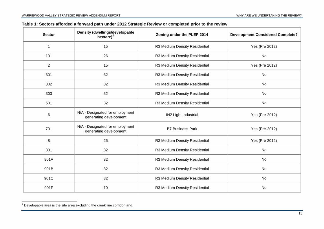
The Warriewood Valley Strategic Review 2012 (2012 Strategic Review) was commenced in 2011 in response to the Planning Assessment Commission’s (PAC) approval of the development at 79-91 Macpherson Street, Warriewood4 under the former Part 3A provisions of the Environmental Planning and Assessment Act 1979 (EP&A Act). In approving the development, the PAC recommended that Council and the then Department of Planning and Infrastructure review the dwelling densities, height controls, the current transport network and necessary improvement works, and infrastructure demands in Warriewood Valley and the surrounding area. The PAC recommended that the review seek to clarify the subregional role of Warriewood Square, how it relates to the rest of Warriewood Valley, the potential for higher density residential development and the opportunity for employment-generating developments adjacent to Warriewood Square. The 2012 Strategic Review investigated all residential sectors within the Release Area considered undeveloped, as well as land within the Southern Buffer. Sectors designated for non-residential development (with the exception of the Southern Buffer) were not investigated. For the majority of undeveloped residential sectors, the 2012 Strategic Review found that residential densities up to a maximum of 32 dwellings per developable hectare could be achieved. Table 1 details the sectors afforded this change under the 2012 Strategic Review, as well as those sectors completed prior to the commencement of the 2012 Strategic Review, requiring no further investigation. Some undeveloped sectors, due to significant environmental constraints were not recommended a forward path under the 2012 Strategic Review, however have been rezoned since the completion of the review.5 These sectors are discussed further in this report to confirm their forward path. These sectors are listed in Table 2. For the remaining sectors not identified with a forward path under the 2010 Strategic Review Council’s resolution of 12 June 2013 identified that a future review would be undertaken to address these. Tables 3 and 4 identify these sectors. Table 3 lists the remaining undeveloped residential sectors that due to significant constraints were not investigated or identified with a forward path under the 2012 Strategic Review. This table also includes Sector 801, which while designated with a forward path in terms of its potential for residential development, was not considered in terms of the location for the Focal Neighbourhood Centre for the Release Area. Table 4 lists the remaining undeveloped land identified as employment generating sectors under the 2010 Planning Framework. This includes the Southern Buffer, which due to the significant environmental constraints and divergent landowner expectations, was not recommended a future land use designation under the 2012 Strategic Review.
4 Property known as 14-18 Boondah Road, Warriewood at time of approval. 5 Council resolution of 12 June 2013.
WARRIEWOOD VALLEY STRATEGIC REVIEW ADDENDUM REPORT WHY ARE WE UNDERTAKING THE REVIEW?
13
Table 1: Sectors afforded a forward path under 2012 Strategic Review or completed prior to the review
Sector Density (dwellings/developable hectare)6 Zoning under the PLEP 2014 Development Considered Complete?
1 15 R3 Medium Density Residential Yes (Pre 2012)
101 26 R3 Medium Density Residential No
2 15 R3 Medium Density Residential Yes (Pre 2012)
301 32 R3 Medium Density Residential No
302 32 R3 Medium Density Residential No
303 32 R3 Medium Density Residential No
501 32 R3 Medium Density Residential No
6 N/A - Designated for employment generating development IN2 Light Industrial Yes (Pre-2012)
701 N/A - Designated for employment generating development B7 Business Park Yes (Pre-2012)
8 25 R3 Medium Density Residential Yes (Pre 2012)
801 32 R3 Medium Density Residential No
901A 32 R3 Medium Density Residential No
901B 32 R3 Medium Density Residential No
901C 32 R3 Medium Density Residential No
901F 10 R3 Medium Density Residential No
6 Developable area is the site area excluding the creek line corridor land.

WARRIEWOOD VALLEY STRATEGIC REVIEW ADDENDUM REPORT WHY ARE WE UNDERTAKING THE REVIEW?
14
Sector Density (dwellings/developable hectare)7 Zoning under the PLEP 2014 Development Considered Complete
9 Fern Creek Road 0 R3 Medium Density Residential No
10 15 R3 Medium Density Residential Yes (Pre 2012)
10B 20 R3 Medium Density Residential No
11 25 R3 Medium Density Residential Yes (Pre 2012)
12 15 R3 Medium Density Residential Yes (Pre 2012)
12A 218 R3 Medium Density Residential Yes (Pre 2012)
20 Less than 10 R3 Medium Density Residential Yes (Pre 2012)
Buffer Area 1A 20 R3 Medium Density Residential Yes (Pre 2012)
Buffer Area 1B 32 R3 Medium Density Residential No
Buffer Area 1C 32 R3 Medium Density Residential No
Buffer Area 1D 32 R3 Medium Density Residential No
Buffer Area 1E 32 R3 Medium Density Residential No
Buffer Area 1F 32 R3 Medium Density Residential No
Buffer Area 1G 32 R3 Medium Density Residential No
Buffer Area 1H 32 R3 Medium Density Residential No
Buffer Area 1I 32 R3 Medium Density Residential No
7 Developable area is the total site area excluding the creek line corridor land, measured as 25 metres either side of the creek centreline. 8 Developed prior to Sector 12 master plan.

WARRIEWOOD VALLEY STRATEGIC REVIEW ADDENDUM REPORT WHY ARE WE UNDERTAKING THE REVIEW?
15
Sector Density (dwellings/developable hectare)9 Zoning under the PLEP 2014 Development Considered Complete
Buffer Area 1J 32 R3 Medium Density Residential No
Buffer Area 1K 32 R3 Medium Density Residential No
Buffer Area 1L 32 R3 Medium Density Residential No
Buffer Area 1M 0 R3 Medium Density Residential No
Buffer Area 2A 25 R3 Medium Density Residential No
Buffer Area 3A 6010 R3 Medium Density Residential Yes (Pre 2012)
Buffer Area 3B 32 R3 Medium Density Residential No
9 Developable area is the total site area excluding the creek line corridor land, measured as 25 metres either side of the creek centreline. 10 Development approved by Planning Assessment Commission under Part 3A of EP&A Act 1979 (provision now repealed).

WARRIEWOOD VALLEY STRATEGIC REVIEW ADDENDUM REPORT WHY ARE WE UNDERTAKING THE REVIEW?
16
Table 2: Sectors rezoned following completion of 2012 Strategic Review
Sector Density (Dwellings/ developable hectare)11 Zoning under the PLEP 2014 Reason for Rezoning
901D and 901E 10 R3 Medium Density Residential
Forward path adopted by Council on 12 June 2013.
Rezoned in accordance with Council decision of 12 June 2013.
901G 10 R3 Medium Density Residential
Forward path adopted by Council on 12 June 2013.
Rezoned in accordance with Council decision of 12 June 2013.
120 Mona Vale Road
Undefined. The property is identified on the Minimum Lot
Size map, allowing the property to be subdivided to a range of lot
sizes.
Part E4 Environmental Living and R2 Low Density Residential
Rezoned by Joint Regional Planning Panel Sydney East (acting as the Relevant Planning Authority).
A portion of site (creekline corridor zoned E2 Environment Conservation) is identified on the Land
Reservation Acquisition Map under PLEP 2014.
122 Mona Vale Road - E2 Environmental Conservation
Rezoned by Joint Regional Planning Panel Sydney East (acting as the Relevant Planning Authority).
The entire site is identified on the Land Reservation Acquisition Map under PLEP 2014.
11 Developable area is the total site area excluding the creek line corridor land, measured as 25 metres either side of the creek centreline.

WARRIEWOOD VALLEY STRATEGIC REVIEW ADDENDUM REPORT WHY ARE WE UNDERTAKING THE REVIEW?
17
Table 3: Remaining residential sectors identified for review
Sector Land Use Designation as per 2010 Planning Framework
Density (Dwellings/ developable
hectare)12 for original ‘whole of sector’13
Zoning under the PLEP 2014 Reason for consideration
3 & Buffer Area 2 Medium Density Residential 25 (Sector 3 and
Buffer Area 2) R3 Medium Density Residential Anomaly due to development across sector boundaries.
801
Medium Density Residential
Identified as location for the Focal Neighbourhood Centre
25 (Sector 8) R3 Medium Density Residential
Schedule 1 Additional Permitted Use14
Sector not confirmed as location for Focal Neighbourhood Centre.
802 Medium Density Residential 25 (Sector 8) RU2 Rural Landscape Current land use inconsistent with Land Use Designation.
901A Mixed Residential 25 (Sector 9) R3 Medium Density Residential Uncertainty surrounding dwelling
yield allocation for individual properties within sector
901C Mixed Residential 25 (Sector 9) R3 Medium Density Residential Sector required to be developed with 901G
901G Mixed Residential 25 (Sector 9) R3 Medium Density Residential Sector required to be developed with 901C
901H Mixed Residential 25 (Sector 9) RU2 Rural Landscape No outcome under 2012 Strategic Review.
10A.1 Mixed Residential 15 (Sector 10) RU2 Rural Landscape No outcome under 2012 Strategic Review.
12 Developable area is the total site area excluding the creek line corridor land, measured as 25 metres either side of the creek centreline. 13 The ‘whole of sector’ approach was established for the Release Area under the Draft Warriewood Valley Planning Framework 1997 and retained until the 2012 Strategic Review. A maximum density was historically allocated across a whole sector, acknowledging that the development within the sector may occur at a range of dwelling densities based on the characteristics and constraints within the sector. 14 Schedule 1, Clause 20 permits development for the purposes of restaurants and cafes and permits neighbourhood shops larger in floor area than otherwise permitted under PLEP 2014.

WARRIEWOOD VALLEY STRATEGIC REVIEW ADDENDUM REPORT WHY ARE WE UNDERTAKING THE REVIEW?
18
Sector Land Use Designation as per 2010 Planning Framework
Density (Dwellings/ developable
hectare)15 for original ‘whole of sector’16
Zoning under the PLEP 2014 Reason for consideration
10A.2 Mixed Residential 15 (Sector 10) RU2 Rural Landscape No outcome under 2012 Strategic Review.
10C Mixed Residential 15 (Sector 10) R3 Medium Density Residential Capacity to be redeveloped.
201 Traditional Residential 8 (Sector 20) SP2 Infrastructure (Cemetery) Current use inconsistent with Land Use Designation.
203 Traditional Residential 8 (Sector 20) R3 Medium Density Residential Residue lot of Sector 20.
204 Traditional Residential Not rezoned with rest of Sector 20
RU2 Rural Landscape Residue lot of Sector 20.
15 Developable area is the total site area excluding the creek line corridor land, measured as 25 metres either side of the creek centreline. 16 The ‘whole of sector’ approach was established for the Release Area under the Draft Warriewood Valley Planning Framework 1997 and retained until the 2012 Strategic Review. A maximum density was historically allocated across a whole sector, acknowledging that the development within the sector may occur at a range of dwelling densities based on the characteristics and constraints within the sector.

WARRIEWOOD VALLEY STRATEGIC REVIEW ADDENDUM REPORT WHY ARE WE UNDERTAKING THE REVIEW?
19
Table 4: Employment generating sectors identified for review
Sector Land Use Designation under 2010 Planning Framework
Zoning of land within the Release Area under the PLEP 2014 Reason for consideration
102 Industrial IN2 Light Industrial Undeveloped residue lot of Stage 1 Release
103 Industrial IN2 Light Industrial Undeveloped residue lot of Stage 1 Release
104 Industrial IN2 Light Industrial Undeveloped residue lot of Stage 1 Release
105 Industrial IN2 Light Industrial Undeveloped residue lot of Stage 1 Release
172 Conservation/Open Space RE1 Public Recreation No outcome under 2012 Strategic Review.
173 Employment Generating SP2 Infrastructure (Sewerage System) No outcome under 2012 Strategic Review.
174 Employment Generating SP2 Infrastructure (Sewerage System) No outcome under 2012 Strategic Review.
Southern Buffer Employment Generating
Part RU2 Rural Landscape, SP2 Infrastructure (Public Administration Building), RE1 Public
Recreation and SP2 Infrastructure (Community Facility)
No outcome under 2012 Strategic Review.

WARRIEWOOD VALLEY STRATEGIC REVIEW ADDENDUM REPORT WHY ARE WE UNDERTAKING THE REVIEW?
20
2.2 Review of other Pittwater-wide policies and studies since the completion of the 2012 Strategic Review 2.2.1 Narrabeen Lagoon Flood Study 2013
A review of the Narrabeen Lagoon Flood Study 1990 commenced in 2010. Narrabeen Lagoon Flood Study 201317 was adopted in November 2013. The study resulted in a slight increase in flood levels from the previously adopted design flood conditions for Narrabeen Lagoon. This information has been incorporated in the flood mapping layer utilised for the composite capability map for this report. The updated flooding information has also been reflected in minor amendments to Council’s planning documents, including the Pittwater 21 Development Control Plan, relevant Section 149(2) notations and the Narrabeen Creek Sea Level Rise Investigation Area.
2.2.2 Pittwater Bushfire Prone Lands Map Council’s bushfire mapping was updated in 2013 in accordance with the
Rural Fires Act 1997 and Environmental Planning and Assessment Amendment Act 2008. The Bushfire Prone Lands Map for Pittwater 2013 was adopted by Council in March 2013 and certified by the Rural Fire Service in June 2013. These maps have been used to inform the composite capability map developed for this report.
2.2.3 Pittwater Public Open Space and Recreation Strategy 2014 In 2012, Council commenced a review of the Pittwater Open Space,
Bushland and Recreation Strategy 2000 and aimed at: • Enhancing existing public open space, sport and recreation networks, • Encouraging social ownership and the desire to protect and use
networks in such a way that enhance Pittwater’s natural areas and cultural heritage.
• Expanding public open space, sport and recreation networks for the benefit of future generations that considers the needs of the community for social interaction, public health, provision of access for all, and that are sustainable in economic and environmental terms.
• Improving the quality of public open space through upgrading and managing existing networks as well as consideration given to purchasing additional land and the sale of surplus land. In particular, additional land for sports fields is required to service the growing population.
The Pittwater Public Space and Recreation Strategy 2014 (Open Space Strategy) identifies: • Opportunities to, where feasible, upgrade and expand the public open
space network for the benefit of the broader community, • The need to promote programs that support social interaction, access
for all and are sustainable in economic and environmental terms,
17 BMT WBM (2013) Narrabeen Lagoon Flood Study 2013, prepared for Warringah and Pittwater Councils.

WARRIEWOOD VALLEY STRATEGIC REVIEW ADDENDUM REPORT WHY ARE WE UNDERTAKING THE REVIEW?
21
• Provision of well designed, safe open spaces that protect and enhance the natural environment, identify cultural heritage and consider aesthetics, sustainability and ‘sense of place’,
• The need to improve equity in the distribution of public open space and recreational opportunities,
• Provision of multi-use spaces that promote intergenerational use including additional opportunities for an ageing population and for children and young people.
Specific recommendations are proposed for tourism opportunities and for the following public spaces: • Nature Conservation Areas, • Walking, Cycling and Equestrian Tracks, • Ocean Beaches, • Foreshore Reserves and Waterways, • Large Developed Parks, • Structured Sports and Recreation Areas, • Sports fields, • Indoor Sports and Recreation Facilities, • Village Greens, Culture and Leisure.
The Open Space Strategy confirms that there is a significant undersupply of recreation areas in the Pittwater Local Government Area (LGA). The review recognised the importance of the release areas (being Warriewood Valley and Ingleside) providing places for recreation and other facilities to meet the needs of their incoming populations to ensure that the demands of any additional population do not further exacerbate the existing shortage of recreation areas. This strategy was adopted by Council on 13 October 2014.
2.3 Moving from the Warriewood Valley Planning Framework 2010
For those lands not identified with a forward path under the 2012 Strategic Review, listed in Tables 3 and 4 above, the 2010 Planning Framework continued to apply as the planning strategy for these sectors. The 2010 Planning Framework specifies a land use designation and, for residential sectors, a maximum residential density. In accordance with Council’s resolution of 12 June 2013, a review of the 2010 Planning Framework as it applies to the remaining lands in the Release Area is necessary to confirm a contemporary forward path for all sectors. The Addendum Report seeks to identify the forward path for the sectors identified in Tables 3 and 4. The Addendum Report also seeks to clarify and correct anomalies that have arisen as sectors within the Release Area have been progressively rezoned and developed.
2.4 Warriewood Valley Section 94 Contributions Plan At its meeting of 12 June 2013, Council in adopting the 2012 Strategic Review also directed that a review of the Section 94 Plan be undertaken to articulate additional infrastructure commensurate with the development anticipated in Warriewood Valley under the 2012 Strategic Review. At the time, among the other additional infrastructure requirements, Council was advised of the increase in open space requirements, particularly the quantum of active open space land for sports fields.

WARRIEWOOD VALLEY STRATEGIC REVIEW ADDENDUM REPORT WHY ARE WE UNDERTAKING THE REVIEW?
22
The review of the Section 94 Plan included the consideration of the recommendations of the Warriewood Valley Strategic Review Economic Feasibility Study (Hill PDA, 2011).18
2.5 Forward Path
The Addendum Report will be a supplement to the 2012 Strategic Review, so as to achieve a single comprehensive document applying to all undeveloped lands in the Warriewood Valley Release Area. The 2012 Strategic Review, together with the Addendum Report, supersede the 2010 Planning Framework, and form the strategic planning framework for the development of land in the Release Area.
18 Hill PDA (2011) Warriewood Valley Strategic Review Economic Feasibility Study, prepared for NSW Department of Planning and Infrastructure and Pittwater Council.

Chapter 3
The Review Process
Photo by: Amanda Clarke 2011

WARRIEWOOD VALLEY STRATEGIC REVIEW ADDENDUM REPORT THE REVIEW PROCESS
24
3.0 The Review Process
3.1 Identifying the land to be reviewed
The PAC’s determination report (2010) advocated for a ‘…comprehensive study of all undeveloped sites in the Valley including the future role of Warriewood Centre and the development potential around the centre…’
The 2012 Strategic Review identified a forward path for undeveloped lands that were capable of intensified residential development, generally at a density up to 32 dwellings per developable hectare. A review of all land parcels in Warriewood Valley was undertaken to identify the sites not afforded a forward path following the completion of the 2012 Strategic Review. In addition several sectors were not investigated by the 2012 Strategic Review as they were considered to be developed. These sectors have been further investigated to ensure a forward path for all properties within the Release Area is provided. Based on the 2012 Strategic Review’s Undeveloped Lands Map,19 the following criteria were used to identify the sites subject to this review: • Sites investigated by the 2012 Strategic Review but outstanding or unresolved
issues remain, • Sites not investigated by 2012 Strategic Review due to employment generating
land use designation under 2010 Planning Framework or zone, • Sites not investigated by the 2012 Strategic Review because they were considered
to be developed or had an approved masterplan applying to the site.
The sectors identified for review are depicted in Map 1.
19 Pittwater Council and Department of Planning & Infrastructure (2012) Warriewood Valley Strategic Review Report 2012, Map 2, p. 29.

WARRIEWOOD VALLEY STRATEGIC REVIEW ADDENDUM REPORT THE REVIEW PROCESS
25
Map 1: Land to be reviewed (corresponds with Sectors listed in Tables 3 & 4)

WARRIEWOOD VALLEY STRATEGIC REVIEW ADDENDUM REPORT THE REVIEW PROCESS
26
3.2 Factors considered during the opportunities and constraints analysis
The following factors were considered during the desktop review to determine the most appropriate land use and a suitable forward path:
• Known environmental affectations, • Zoning under the PLEP 2014,20 • Existing development on the site and likelihood of redevelopment, • Outcomes and recommendations of various development assessments
previously undertaken for particular sites, • Recommendations of Council’s contemporary strategic and land use planning
policies. The process for assessing known environmental affectations is discussed in more detail in Section 3.3.
3.3 Process for assessing environmental affectations
The land capability mapping exercise utilised for the 2012 Strategic Review was again used for this review to assess environmental affectations. Since the completion of the 2012 Strategic Review, Council has acquired more current flooding and bushfire data. This information has been incorporated into the bushfire and flooding map layers which were utilised for land capability mapping exercise undertaken for this review (see Appendix 1). The land capability mapping process builds geographical layers to produce a visual representation of areas with lower or higher levels of development capability. Seventeen individual base map layers have been prepared for the Pittwater Local Government Area, each map representing an environmental, economic or social characteristic that influences land use decisions. The map layers also identify issues that should be addressed in the future management of the land. The following layers were used to prepare the overall Composite Capability Map. • Bushfire (updated based on Bushfire Prone Lands Map for Pittwater 2013
adopted by Council on 4 March 2013 and certified by the Rural Fire Service on 17 June 2013),
• Flooding (updated based on Narrabeen Lagoon Flood Study 2013 adopted by Council on 4 November 2013),
• Acid sulphate soils, • Biodiversity, • Climate change including sea level rise, • Coastal processes, • Cultural (heritage value), • Estuarine processes, • Foreshores and water bodies, • Geotechnical, • Proximity to ridgelines, • Proximity to watercourses, • Sewer availability, • Slope, • Water availability.
20 Pittwater Local Environmental Plan 2014 (PLEP 2014) was published and came into effect on 27 June 2014. The provisions of the published LEP were considered in finalising this report.

WARRIEWOOD VALLEY STRATEGIC REVIEW ADDENDUM REPORT THE REVIEW PROCESS
27
The constraints map layers have been divided into the following three classes:
• Class A: Low restriction to intensification of development. Existing development may require generic management prescriptions to achieve sustainable land use. Intensification of development must be confined to defined targets to maintain sustainability.
• Class B: Moderate restriction to intensification of development.
Existing development forms require generic management prescriptions to achieve sustainable land use. Any intensification needs site specific investigation and must address constraints.
• Class C: Significant restriction to intensification of land use. Existing development forms require site specific and detailed management prescription to achieve sustainable land use. Any intensification must fully address each specific constraint.
The map layers are combined into a single layer to form a Composite Capability Map, categorising the land in terms of its level of development capability. The land capability classifications are outlined in Table 5. Table 5: Land capability classifications
For the purpose of this review, the Composite Capability Map produced did not include the proximity to centres and public transport links base map layers as these issues will not significantly affect the development capability of the land. This is consistent with the approach applied for the 2012 Strategic Review. The outcomes of the land capability exercise are discussed in Chapter 4. The Composite Capability Map produced for this review is depicted in Chapter 4 in Map 2.
Map Classification Level of Capability Categories from Composite Maps
1 Most All A’s: areas of land that were mapped
as suitable for development or intensification.
2 More
All A and B: areas of land that were mapped as having at least one moderate
constraint to development or intensification.
3 Moderate
Only have one instance of C: areas of land that were mapped as having one severe constraint to development or
intensification.
4 Less
Two instances of C: areas of land that were mapped as having two instances of
a severe constraint to development or intensification.
5 Least
Three or more instances of C: areas of land that were mapped as having three or more severe constraints to development
or intensification.

WARRIEWOOD VALLEY STRATEGIC REVIEW ADDENDUM REPORT THE REVIEW PROCESS
28
3.4 Community engagement process A strategy for community engagement was devised for this review based on Council’s Community Engagement Policy and Procedures. The strategy includes the following:
• Notification to all affected landowners of the recommendations of the draft Addendum Report, inviting them to meet with Council staff to discuss the recommendations for their property,
• Notification to the local community representative group which represents the interest of Warriewood Valley landowners advising them of the release of the draft Addendum Report,
• Media releases and website updates, • Advertisement in the local newspaper advising of the exhibition of the draft
Addendum Report, and • Public exhibition of the draft Addendum Report for a minimum of 28 days.
The implementation of the strategy has ensured that all stakeholders in the community, whether affected directly or indirectly by the recommendations of the draft Addendum Report, were adequately informed and provided with opportunities to voice their concerns.
3.5 Probity Advisor It was identified that probity issues could arise from the mixed ownership of land in the Warriewood Valley Release Area, being Crown, Council and privately owned land. A probity advisor was engaged to oversee the governance established for the completion of this review and to prevent real and perceived conflicts of interest. The scope of works undertaken by the probity advisor includes:
• Providing probity advice and services in relation to the public exhibition of the draft Addendum Report,
• Attending meetings with landowners during the exhibition period where it is deemed there may be a potential conflict of interest, and
• Overseeing the submission review process and, where necessary, providing advice on key decisions associated with finalising the Addendum Report.
The probity advisor has audited the processes undertaken in finalising this report and prepared a Probity Report that accompanies the Addendum Report.

Chapter 4
Results
Photo by: Amanda Clarke 2011

WARRIEWOOD VALLEY STRATEGIC REVIEW ADDENDUM REPORT RESULTS
30
4.0 Results
4.1 Summary of results
The desktop review identified a number of sectors constrained by environmental affectations or by their existing development or land uses. The most significant constraints included the following:
• Bushfire, • Flooding, • Access, • Biodiversity, • Site configuration and size.
Conversely, other sectors were relatively less constrained and identified as having future development opportunities.
The land capability assessment undertaken for this review has produced a Composite Capability Map depicted in Map 2. This chapter summarises the outcomes of the opportunities and constraints analysis process (as described in Section 3.2 and 3.3) undertaken for each sector. The detailed opportunities and constraints analysis for individual sectors is contained in Appendix 2.

WARRIEWOOD VALLEY STRATEGIC REVIEW ADDENDUM REPORT RESULTS
31
Map 2: Composite Capability Map

WARRIEWOOD VALLEY STRATEGIC REVIEW ADDENDUM REPORT RESULTS
32
4.2 Undeveloped sectors with limited capacity for development
The desktop review identified undeveloped lands on the fringe of the Release Area with limited capacity for development due to bushfire, biodiversity, topography and access constraints due to their proximity to the Ingleside Chase Reserve. These undeveloped lands are:
• Sector 201 and 204, • Sector 702, • Sector 901H, • Sectors 10A.1 and 10A.2.
The following sections discuss these sectors in more detail. 4.2.1 Sectors 201 and 204
Sector 201, currently designated for future residential development, is a triangular shaped allotment used by/for Mona Vale cemetery. It is zoned SP2 Infrastructure (Cemetery) under the PLEP 2014. It is unlikely to be developed in accordance with the prescribed land use designation under the 2010 Planning Framework.
Sector 204 currently contains the AVEO Peninsular Gardens Retirement Village. This is a subsidiary sector of Sector 20 and was not afforded a density under the approved masterplan for Sector 20. It was considered to be developed at the time the Sector 20 masterplan was produced. Given this and as the property is heavily vegetated, bushfire prone and flood affected, it is unlikely that Sector 204 will be redeveloped in the future.
4.2.2 Sector 702
Sector 702, currently designated for employment generating development, is a rural zoned residue of Sector 7. The development potential of Sector 702 for future employment is unlikely given the property comprises part of the Pittwater Uniting Church. For development on Sector 702 to be realised, it will require excising this portion of land from the current land parcel with provision for safe and viable access from Jubilee Avenue.
4.2.3 Sector 901H
The land capability of Sector 901H is diverse. The majority of Sector 901H, adjacent to the Ingleside Chase Reserve, is significantly constrained due to bushfire hazards and proximity to dense vegetation, and has no likely prospects for urban development. Conversely, the battle-axe handles of Sector 901H (being the portion of the driveways of 4 & 5 Fern Creek Road within the Release Area) are less constrained. The development potential of this portion of the sector may be realised, with the size of the battle-axe handles being 1,138m². If developed, access to 4 and 5 Fern Creek Road must be ensured. Better development outcomes will be achieved if the battle-axe handles of Sector 901H are developed with either 901B or 901C. The onus will be on land owners for these sectors to work collaboratively and contemplate amalgamation with the adjoining sectors.

WARRIEWOOD VALLEY STRATEGIC REVIEW ADDENDUM REPORT RESULTS
33
Since the exhibition of the Addendum Report, a development application has been lodged for Sector 901B, which did not incorporate Sector 901H. In the event that the amalgamation is not possible, any development at this location must address how access will be retained for 4 and 5 Fern Creek Road as well as incorporate other environmental and associated infrastructure requirements, such as water management, into their proposal.
4.2.4 Sectors 10A.1 and 10A.2
The development potential of Sectors 10A.1 and 10A.2 is particularly limited due to their proximity to dense vegetation and bushfire hazards. Given these constraints, in addition to the size and configuration of these sites, there is little potential for these sectors to be developed for urban purposes.
4.3 Residential sectors with development potential and/or requiring clarification
The following sectors have been identified with development potential and have either been recommended with a forward path under the Addendum Report or their forward path previously identified needs clarification. These sectors include the following:
• Sectors 202 and 203, • Sector 10C, • Sectors 901D and 901E, and 901C and 901G, • Sector 801, • 120 and 122 Mona Vale Road, • Sector 3 and Buffer Area 2, and • 802.
The following sections discuss these sectors in more detail. 4.3.1 Sectors 202 and 203
Sectors 202 and 203 are considered constrained, however have been largely cleared of significant vegetation and are large enough to achieve some development potential. Nonetheless, Sector 203 has some significant access issues due to its topography. Whilst Sector 202 has adequate access and the portion within the Release Area is primarily cleared, it has recently been developed for a single dwelling and there is little potential for any future redevelopment. However, it is recognised that these sectors may have opportunities for low density development subject to these constraints being adequately addressed.
4.3.2 Sector 10C
Sector 10C a residue parcel of Sector 10. It was developed as seniors living development prior to the master planning of Sector 10. Sector 10C is an underutilised site and possesses few constraints. This sector adjoins Irrawong Reserve and is at the southern entrance of Warriewood Valley. Sector 10C has potential to be redeveloped at a similar scale to neighbouring developments. During the 2012 Strategic Review process the landowners of Sector 10C expressed their desire to redevelop this property.
4.3.3 Sectors 901D and 901E, and 901C and 901G
Sector 901D is constrained by biodiversity, visual impact issues and high voltage overhead cables while Sector 901E comprises a battle-axe handle only. It was recognised during the 2012 Strategic Review that there was

WARRIEWOOD VALLEY STRATEGIC REVIEW ADDENDUM REPORT RESULTS
34
potential for Sectors 901D and 901E including the Orchard Street road reserve (north-east portion) to conglomerate, enabling more appropriate setbacks to constraints while maximising development potential across these sectors (up to 16 dwellings). Sector 901G being a land-locked parcel, is located between the Ingleside Chase Reserve and Sector 901C. Given that Sectors 901G and 901C are under the same ownership it was recommended that they develop together (with the majority of the development being placed on 901C, in recognition of the asset protection zone and creekline buffer requirements constraining development of Sector 901G).21 These sectors were rezoned for residential development, consistent with Council’s decision of 12 June 2013.
4.3.4 Sector 801 and location of Focal Neighbourhood Centre
The 2010 Planning Framework identified 23B Macpherson Street (now known as Sector 801) as the preferred site for the Focal Neighbourhood Centre (FNC). The FNC with a gross floor area between 855m²-2,222m² is planned to be developed to meet the retail needs of the incoming population. It is intended to provide goods and services in the form of a small general store, Post Office and coffee shop for example. This is reflected in Schedule 1 of the PLEP 2014.22 This sector is permitted to develop up to 32 dwellings per developable hectare in accordance with 2012 Strategic Review recommendations. In July 2011 development consent was granted for the construction of an infill affordable housing development consisting of 46 residential townhouses and a Focal Neighbourhood Centre. This development is currently under construction. The Focal Neighbourhood Centre, approved as part of this development, satisfies the planned location of Focal Neighbourhood Centre.
4.3.5 120 and 122 Mona Vale Road
The properties 120 (identified as Clause 6.2 on the Urban Release Area Map under the PLEP 2014) and 122 Mona Vale Road are significantly constrained. The sites are affected by environmental constraints, being slip, bushfire, and significant vegetation, and the sites contain the upper reaches of Narrabeen Creek. Access is limited to a single driveway from Mona Vale Road and a right of carriageway from 10 Jubilee Avenue. 120 Mona Vale Road was identified in Warriewood Valley Release Area through a Council decision in 2007. At the time of preparing the draft Addendum Report the Joint Regional Planning Panel Sydney East (JRPP) was in the process of progressing a Planning Proposal to rezone 120 and 122 Mona Vale Road.23 These properties have now been rezoned via an amendment to the PLEP 2014 (identified as Clause 6.2 on Urban Release Area Map).24
21 Both parcels owned by the same owner at 12 June 2013 Council decision. 22 Schedule 1, Clause 20 permits development for the purposes of restaurants and cafes and permits neighbourhood shops larger in floor area than otherwise permitted under PLEP 2014. 23 The JRPP was nominated as the Relevant Planning Authority for the Planning Proposal lodged for 120-122 Mona Vale Road as Council did not support the initial Planning Proposal application. 24PLEP 2014, Amendment 1.

WARRIEWOOD VALLEY STRATEGIC REVIEW ADDENDUM REPORT RESULTS
35
The amendment zoned the property 120 Mona Vale Road part E4 Environmental Living, R2 Low Density Residential and E2 Environment Conservation (portion containing the creek line corridor). The property 122 Mona Vale Road has been zoned entirely E2 Environment Conservation.
4.3.6 Anglican Retirement Village development within Sector 3 and Buffer
Area 2
Originally several properties comprised Sector 3 and Buffer Area 2. Formerly Sector 3 comprised: • 20 Macpherson Street (now known as Sector 301) • 18 Macpherson Street (now known as Sector 302) • 16 Macpherson Street (now known as Sector 303) • 14 Macpherson Street (now known as Sector 3)
Formerly Buffer Area 2 comprised: • 6 to 12 Macpherson Street (now known as Buffer Area 2) • 4 Macpherson Street (now known as Buffer Area 2a)
Prior to the 2012 Strategic Review, the pre-planning for these properties had envisaged a ‘whole of sector’ density of 25 dwellings per developable hectare. In April 2006 development consent was granted to construct the Anglican Retirement Village (ARV) seniors living development across 6 to 14 Macpherson Street. This development, straddling across part of the former Sector 3 and part of former Buffer Area 2, was approved under the former State Environmental Planning Policy No.5 Seniors Living and was slightly above the anticipated density. As the ARV development was partially completed when the 2012 Strategic Review commenced, the properties now named Sector 3 (14 Macpherson Street) and Buffer Area 2 (6-12 Macpherson Street) were not reviewed. The remaining undeveloped sectors being Sectors 301, 302, 303 and Buffer Area 2A were reviewed under the 2012 Strategic Review. The density of up to 32 dwellings per developable hectare was recommended for Sectors 301, 302 and 303 enabling each sector to develop to that density. The density recommended for Buffer Area 2A was 22 dwellings per developable hectare. PLEP 2014 allocated dwelling yields for Sector 3 and Buffer Area 2, representing a density of up to 25 dwellings per developable hectare in accordance with the 2010 Planning Framework; while the yield allocated to Sectors 301, 302, 303 and Buffer Area 2a was in accordance with the 2012 Strategic Review recommendations. Given that the overall ARV development is nearing completion, Sector 3 and Buffer Area 2 are unlikely to be redeveloped in the short to medium term.

WARRIEWOOD VALLEY STRATEGIC REVIEW ADDENDUM REPORT RESULTS
36
4.3.7 Existing development on Sector 802 Mater Maria Catholic College is located on Sector 802. The sector is a residue of the master planned sector known as Sector 8. The current land use designation for Sector 802 is part ‘Medium Density Residential’, part ‘Conservation/Open Space’. Given the existing development precludes any future residential development; the land use designation should be changed to reflect the existing use.
4.4 Southern Buffer and Sectors 172, 173 and 174
The 2012 Strategic Review investigated development opportunities for the Southern Buffer (including Sectors 172, 173 and 174) however due to the significant environmental constraints and divergent landowner expectations, no future land use was recommended for this area. The 2012 Strategic Review invited landowners, either individually or collectively, to pursue development opportunities for their lands through the lodgement of a Planning Proposal addressing, as a minimum, the constraints identified during the 2012 Strategic Review. The 2012 Strategic Review identified flooding as a major constraint to any future development. The majority of the properties within the Southern Buffer are low lying and are inundated during flood events. Flood depths reach approximately 1-2 metres above natural ground level across most of the Southern Buffer and flood events are typically long in duration and influenced by backwater flooding from the Warriewood Wetlands and Narrabeen Lagoon. These findings were reiterated in the Narrabeen Lagoon Flood Study 2013. 4.4.1 Warriewood Valley Strategic Review Hydrology Study 2011
The Warriewood Valley Strategic Review Hydrology Study 2011 (2011 Hydrology Study) undertaken for the 2012 Strategic Review classified land into developable land categories (based on criteria set out in the 2011 Hydrology Study) and recommended land uses for each category. The recommended land uses for each category are as follows:
• Category A: “No aged care facilities, retirement villages, educational establishments, child care centres and other essential services,”
• Category B: “Most land uses are permitted… assuming that they comply with relevant policies on floor levels and other constraints.”
• Category D: “Most land uses are permitted… assuming that they comply with relevant policies on floor levels and other constraints.”
• Category F: “Sporting fields and recreational areas are the only land use recommended.”
• Category G: “Commercial and industrial land uses recommended.” • Note: No areas within the Release Area are classified Category C or E.
In relation to the Southern Buffer, the Study classified:
• Northern section as part Category B and part Category D. • Southern section (at junction of Jacksons Road and Pittwater Road) as
Category G. • Remaining lands (being 2, 4 and 6 Jacksons Road; 1, 2, 2A, 3, 4A, 6, 8
and 10 Boondah Road; and Sectors 172, 173 and 174) as Category F. This Study, in considering potential development opportunities, recommended the creation of two developable islands at the highest points within the sector. This was to be achieved through significant excavation and filling in parts of the sector. Under this scenario, the central areas of the Southern Buffer were

WARRIEWOOD VALLEY STRATEGIC REVIEW ADDENDUM REPORT RESULTS
37
determined suitable for open space only due to flood depths and flow path requirements.25 Sector 172, being 7,792m² in area, containing significant vegetation and a section of Narrabeen Creek, is classified Category F and is the only remaining portion of Sector 17 not owned by Sydney Water or within the Warriewood Sewerage Treatment Plant. Sectors 173 and 174, contain vegetation and are classified Category F. Sydney Water, as the owners of Sectors 173 and 174, has confirmed during the 2012 Strategic Review, that these sectors are required for works associated with the Sewerage Treatment Plant.
4.4.2 Recent review following adoption of the Narrabeen Lagoon Flood Study 2013
Due to revised flood modelling under the Narrabeen Lagoon Flood Study 2013, Cardno was commissioned to review the flood behaviour in the Southern Buffer area and have regard to the recommendations made for these lands under the 2011 Hydrology Study. The review identified that the floor levels required for development would increase from the 2011 Hydrology Study. In addition the evacuation potential would not be improved. The review also confirmed that the majority of the Southern Buffer land continues to be classified as Category F consistent with the recommendations of the 2011 Hydrology Study. It reaffirmed the land uses recommended for Category F classification is sporting fields and recreational areas only.
4.4.3 Review of existing Council policies and studies Council, in considering the recommendations of the 2012 Strategic Review, was advised there were additional infrastructure requirements commensurate with the additional demand as a result of the increased development. At that time, it was identified that up to 5 hectares of additional recreational area was required to be purchased.26 As outlined in Section 2.2.3, the Pittwater Public Space and Recreation Strategy 2014 recognises the importance for the Release Areas (Warriewood Valley and Ingleside) to provide recreation areas and facilities to meet the needs of their incoming populations to ensure that the demands of any additional population do further exacerbate the existing shortage of recreation areas in the balance of the Pittwater LGA. As outlined in Section 2.4, a review of local infrastructure commensurate with the increased dwellings forecast under the 2012 Strategic Review has been undertaken. The Draft Warriewood Valley Section 94 Contributions Plan identified the quantum of recreational area required for the total development anticipated in the Release Area. The Draft Warriewood Valley Section 94 Contributions Plan, taking into account what available land is remaining in and adjacent to Warriewood Valley, has identified land in the Southern Buffer as suitable for use as a recreation area. The aggregated site area of the identified lands in the Southern Buffer is close to the quantum required to be provided.
25 Cardno (NSW/ACT) Pty Ltd (2011) Warriewood Valley Strategic Review Hydrology Study, prepared for Department of Planning & Infrastructure and Pittwater Council. 26 Council Report to Item C5.1 entitled Warriewood Valley Strategic Review Report – Outcomes of public exhibition and final report, extraordinary Council meeting 12 June 2013, p. 26.

WARRIEWOOD VALLEY STRATEGIC REVIEW ADDENDUM REPORT RESULTS
38
4.4.4 Planning Proposal lodged for privately owned lands in the Southern Buffer
A Planning Proposal has been lodged for the privately owned lands in the Southern Buffer, namely 6 Jacksons Road and 3, 6, 8, 10 and 12 Boondah Road, Warriewood. The proposal envisaged a large mixed use development within the sector comprising retail, commercial and residential uses.27 Don Fox Planning were commissioned by Council to undertake an assessment of the Planning Proposal. The application was not supported for the following reasons:
• It did not meet the strategic objectives of the Draft North East Subregional Plan, SHOROC Employment Lands Study, Pittwater Local Planning Strategy and Warriewood Valley Strategic Review Report through the expansion of Warriewood Square shopping centre to provide a new town centre;
• It would result in unacceptable adverse outcomes for public open space and recreation areas within the Southern Buffer;
• It was inconsistent with Section 117 Direction 4.3 Flood Prone Land; • The approach to managing flooding constraints to justify the urban
zone on flood prone land was not supported; • It failed to retain and protect high value biodiversity land (including
Endangered Ecological Communities (EEC’s)) and provided insufficient justification for their removal or consideration of ecological recommendations;
• It was unable to achieve connectivity between the Site and adjoining commercial areas (including relocated Boondah Road and Vuko Place connection) on the basis of unacceptable ecological and traffic impacts;
• It did not address potential negative economic impacts upon surrounding retail centres, or address the potential oversupply of commercial floor space;
• The urban design outcomes of the Masterplan were not supported; and • It did not adequately represent the interests of all affected land
owners.28
Additionally, Don Fox Planning recommended that any future planning proposal should incorporate all land within the Southern Buffer and also the Warriewood Square Shopping Centre site. A Pre-Gateway Review request is currently being considered by the Department of Planning and Environment. To date, no decision has been made to this request.
4.5 Other employment generating sectors
All remaining employment generating lands, except for Sector 702 and the Southern Buffer including Sectors 172, 173 and 174, are already zoned to permit employment generating land uses. While they have few environmental affectations, they are constrained due to their size and configuration.
27 Planning Proposal application prepared by SJB Planning (NSW) Pty Ltd (March 2014). Council’s reference number for this application is PP0007/13. 28 Reasons for refusal as appeared in the Council determination issued 18 March 2014, in accordance with Council resolution of 17 March 2014.
WARRIEWOOD VALLEY STRATEGIC REVIEW ADDENDUM REPORT RESULTS
39
Sectors 102 and 105, while relatively small, are able to be developed on their own. Nonetheless, a better development outcome could be achieved if these sectors amalgamate. Sector 103 is comprised of multiple small land parcels with an average site area of 910m², each with a different landowner. Given the size of individual land parcels, redevelopment of this sector can only be achieved through lot consolidation. Sector 104, due to its size and configuration, is difficult to develop. There is however, a range of development uses permissible within the IN2 Light Industrial zone that may be able to be achieved within this relatively small site.

WARRIEWOOD VALLEY STRATEGIC REVIEW ADDENDUM REPORT
40
THIS PAGE HAS INTENTIONALLY BEEN LEFT BLANK

Chapter 5
Recommendations
Photo by: Amanda Clarke 2011

WARRIEWOOD VALLEY STRATEGIC REVIEW ADDENDUM REPORT RECOMMENDATIONS
42
5.0 Recommendations
5.1 Introduction The Addendum Report has reviewed the development potential of sectors that were excluded from the 2012 Strategic Review. The opportunities and constraints analysis has identified a number of sectors constrained by environmental factors or by their existing development or current use, as well as other relatively less constrained sectors with future development opportunities. Due to significant environmental and developmental constraints affecting particular sectors, a number of sites are recommended to be removed from the Release Area or for more suitable land uses. This review has also identified other relatively less constrained sectors with opportunities for development. Based on this analysis, the Addendum Report recommends a number of amendments to the Release Area boundary and the land uses designated for particular sectors under the 2010 Planning Framework. The review has also recommended the rezoning of two sectors and amendments to specific sector yields. The Addendum Report also recommends amendments to the Warriewood Valley Release Area Map, Residential Density Map and Land Use Designation Map (see Maps 3, 4 and 5 respectively).
5.2 Recommendations for residential sectors
5.2.1 Developed sectors (Sectors 802, 10C, Sector 3 and Buffer Area 2)
Sector 802 is constrained by the existing development on the site that is likely
to preclude any future residential development. The land use designation of Sector 802 should be ‘Infrastructure’ rather than ‘Residential - Medium Density’ in recognition of the Mater Maria Catholic College on this site. It is recommended to rezone the entire site to an infrastructure zone, consistent with the zoning of other schools in the Pittwater LGA. The sector boundary is not proposed to be amended. Sector 10C, consistent with landowner aspirations expressed during the exhibition of the 2012 Strategic Review, has potential to be developed for low density residential purposes, in keeping with the pattern and scale of the surrounding development. It is recommended that the sector be allocated a dwelling yield consistent with the adjoining Sector 10. This will ensure a consistent streetscape character is maintained along this section of Garden Street.
The Anglican Retirement Village (ARV) development, partially completed, straddles Sector 3 and Buffer Area 2. Given the approved development, it is appropriate to amalgamate these sectors (resulting in a revision of the sector boundary) and relabel it ‘Buffer Area 2’. It is recommended that the new Buffer Area 2 have a land use designation of ‘Residential - Medium Density’, retaining the density of 25 dwellings per developable hectare allocated under the 2010 Planning Framework.

WARRIEWOOD VALLEY STRATEGIC REVIEW ADDENDUM REPORT RECOMMENDATIONS
43
Detailed recommendations for the above listed sectors are in Appendix 3.
5.2.2 Undeveloped sectors to be removed from the Release Area (Sectors 201, 204, 10A.1 and 10A.2, and Part of 901H)
The majority of remaining undeveloped residential sectors are located on the fringe of the Release Area at the base of Ingleside Chase Reserve and therefore are limited in their ability to develop due to bushfire, geotechnical hazards and access issues. Several sectors are also unlikely to be redeveloped due to the existing development on the site or their current use.
Given the above, a number of sectors are recommended to be removed from the Release Area as they are unlikely to be developed for urban purposes in the future. These sectors include Sectors 201, 204, 10A.1, 10A.2 and the western portion of 901H. Detailed recommendations for the above listed sectors are in Appendix 3.
5.2.3 Undeveloped sectors recommended for development (Sectors 202, 203,
Revised 901H)
This review also identified a small number of other sectors, which, while constrained, are able to achieve low density development. These sectors are 202 and 203. It is recommended that a yield of 1 dwelling be allocated to Sector 202 and a yield of 4 dwellings be allocated to Sector 203.
This review has identified revised Sector 901H (comprising only the battle-axe portion) as having capacity to be developed in the future. As discussed in section 4.2.4, the original Sector 901H consisting a bulb-shaped area immediately adjoining Ingleside Chase Reserve is significantly constrained and has limited prospects for urban development.
Redefining the sector to only comprise the battle-axe portion to facilitate development opportunity is reasonable so long as access to 4 and 5 Fern Creek Road is retained. Additionally, the size and shape of the battle-axe necessitates the revised Sector 901H being integrated with the adjoining sectors (901B or 901C) to facilitate better development outcomes. Any density allocated to the now revised Sector 901H needs to be consistent with adjoining sectors to provide incentive for amalgamation with Sector 901B and/or 901C to be realised.
In the event that amalgamation cannot be achieved, it will be difficult for this revised sector to develop on its own given its size, the associated infrastructure requirements as well as ensuring unimpeded access is available for 4 and 5 Fern Creek Road.
It is recommended that the sector boundary is revised to only contain the battle-axe portion of 4 and 5 Fern Creek Road (to be known as Sector 901H) and for the revised sector to be rezoned to allow residential development of up to 3 dwellings (representing a density of 32 dwellings per developable hectare identical to the adjoining sectors). It is also recommended that the revised Sector 901H be allocated a land use designation of ‘Residential - Medium Density’. Nonetheless, the onus will be on landowners to negotiate opportunities for amalgamation to realise development potential on revised Sector 901H.

WARRIEWOOD VALLEY STRATEGIC REVIEW ADDENDUM REPORT RECOMMENDATIONS
44
Detailed recommendations for the above listed sectors are in Appendix 3.
5.2.4 Sectors 901D and 901E, 901C and 901G
Concurrent to the adoption of the 2012 Strategic Review, Council agreed to rezone the following sectors: • Sectors 901D and 901E (to be developed together and agreed to by
landowners of these sectors), and • 901G to be developed with 901C (under the same ownership), and allocated a yield consistent with Council direction on 12 June 2013. The Addendum Report does not recommend any change to their existing zoning or yield however, reiterates the land use designation, reflecting Council’s 2013 decision for these sectors. The anticipated development of Sectors 901C and 901G has not been reflected in the PLEP 2014, appearing as separate sectors, contrary to Council’s decision.29 Accordingly it is recommended that Sectors 901C and 901G be identified in the PLEP 2014 together, with one yield, consistent with Council’s 2013 decision.
5.2.5 120 and 122 Mona Vale Road
120 and 122 Mona Vale Road have already been rezoned via a Planning Proposal. Based on the approved zoning, 120 Mona Vale Road is recommended to have a ‘Residential - Low Density’ designation and 122 Mona Vale Road is recommended to have a ‘Conservation’ land use designation. There is no yield specified for this sector as it reverts to a minimum lot size map. Detailed recommendations for the above listed sectors are in Appendix 3.
5.2.6 Sector 801
Sector 801, known as 23B Macpherson Street, was identified as the preferred site for the Focal Neighbourhood Centre in the 2010 Planning Framework. Development consent has been granted to develop this sector to include a Focal Neighbourhood Centre. Schedule 1 of the PLEP 2014 lists development for the purpose of restaurants, cafes and neighbourhood shops as additional permissible land uses for this sector reflecting the aspirations in the 2010 Planning Framework for this site. Under this circumstance, it is recommended that for Sector 801:
• the land use designation for this sector be altered to ‘Residential-
Medium Density and Focal Neighbourhood Centre’, and • Control C6.15 of Pittwater 21 DCP be amended to specifically identify
23B Macpherson Street (Sector 801) as the location for the Focal Neighbourhood Centre.
Detailed recommendations for the above listed sectors are in Appendix 3.
29 Council’s resolution of 12 June 2013.

WARRIEWOOD VALLEY STRATEGIC REVIEW ADDENDUM REPORT RECOMMENDATIONS
45
5.2.6 Clarification of dwelling yield allocation within Sector 901A
The 2012 Strategic Review recommended Sector 901A have a density up to 32 dwellings per developable hectare and expressly allowed individual properties to develop to that density. This sector has now been rezoned in accordance with those recommendations and allocated a total yield of 192 dwellings. This number represents the total sum of dwellings calculated on a pro-rata basis for the individual properties within the sector. The calculation below expresses how this number was determined.
To provide certainty should individual parcels develop on their own, the pro-rata dwelling yield allocation of the individual land parcels within Sector 901A is identified in Table 6. In the development of these sites, it must be demonstrated that they are capable of developing on their own as well as demonstrating how the development (within individual parcels) will connect to adjoining future developments on adjoining properties. It will also need to be demonstrated how these development sites can be developed in an orderly manner in accordance with clause 5(a)(ii) of the EP&A Act 1979.
(Developable area of land parcel x 32)/10,000 = Yield for individual land parcel per 10,000m2

WARRIEWOOD VALLEY STRATEGIC REVIEW ADDENDUM REPORT RECOMMENDATIONS
46
Table 6: Pro-rata dwelling yield for individual parcels in Sector 901A
Address Developable Area+ (m²) Density range Minimum Yield Maximum Yield Comments
9 Fern Creek Road 9,297 25 to 32 0 0
This parcel was bought by Council for recreation purposes. Under the 2012 Strategic Review it was zoned R3 with no dwelling yield allocated against the parcel.
13 Fern Creek Road 606 25 to 32 2 2 -
6 Orchard Street 15,170 25 to 32 39 48 6 and 6A Orchard Street are to be developed
together. 6A Orchard Street 284
4 Orchard Street 10,496 25 to 32 27 33 4 and 4A Orchard Street are to be developed
together. 4A Orchard Street 289
206 Garden Street 3,149 25 to 32 8 10 -
204 Garden Street 7,082 25 to 32 18 23 -
2 Orchard Street 13,320 25 to 32 35 43 2 and 2A Orchard Street are to be developed
together. 2A Orchard Street 573
10 Fern Creek Road 10,240 25 to 32 27 33 -
TOTAL 60,063 156 192 + Individual site area excluding creek line corridor

WARRIEWOOD VALLEY STRATEGIC REVIEW ADDENDUM REPORT RECOMMENDATIONS
47
5.2.7 Facilitating quality medium density housing The 2012 Strategic Review allows individual properties within sectors to
develop on their own. At a density of 32 dwellings per developable hectare, the typical housing form is townhouses, terrace housing and low-rise residential flat buildings. Recent experience demonstrates a trend in land subdivision proposals for detached dwellings on lots less than 300m2. At this lot size, even modest dwellings result in numerical non-compliance with the current Pittwater 21 DCP controls. In recognition of this issue, it is recommended that a comprehensive review of the Pittwater 21 DCP occur to provide updated controls that cater for dwellings on smaller lot sizes.
Until this review is complete it is recommended that integrated housing
developments be pursued. Integrated housing, as a form of development incorporates land subdivision and dwellings on individual lots in the same application. It facilitates detailed assessment of the subdivision of the land, provision of infrastructure and the design of dwellings on the smaller lots resulting in a more comprehensive consideration of the associated planning and built form outcomes.
5.3 Recommendations for the Southern Buffer and Sectors 172, 173 and 174
In light of contemporary information available since the completion of the 2012 Strategic Review, the Addendum Report has reviewed the opportunities and constraints in order to determine the most appropriate forward path for the Sectors 172, 173 and 174 and the broader Southern Buffer.
5.3.1 Recommended sector boundary re-alignment
Sector 172, formerly part of Sector 17, is the remaining portion of Sector 17 that is not owned by Sydney Water or within the Warriewood Sewerage Treatment Plant. This sector comprises a section of Narrabeen Creek and significant vegetation, and provides connectivity with the creekline corridor network to the Southern Buffer Sector. Rather than creating a single sector, its utility may be best served by being incorporated into the Southern Buffer Sector. During the 2012 Strategic Review process Sydney Water confirmed, as the owner of Sectors 173 and 174 that these sectors are required for works associated with the Sewerage Treatment Plant. Given these circumstances, Sectors 173 and 174 are recommended to be removed from the Release Area. Concurrence for removal of Sectors 173 and 174 has now been received from Sydney Water.
5.3.2 Recommended land use designation
A review of the lands within the Southern Buffer based on the Narrabeen Lagoon Flood Study 2013, identified that the floor levels required for development would increase. The Category F classification for the majority of land in the Southern Buffer remains. Under this category the land uses recommended are restricted to sporting fields and recreational areas.
The property 1 Boondah Road currently contains Council’s Operations Centre and is not likely to be relocated in the near future. It is zoned SP2 Infrastructure (Public Administration Building) and it is recommended that this property be designated ‘Infrastructure’ and still remain in the Southern Buffer Sector.

WARRIEWOOD VALLEY STRATEGIC REVIEW ADDENDUM REPORT RECOMMENDATIONS
48
Sector 172 contains significant vegetation, a portion of the Narrabeen Creek and is bushfire prone land. Its environmental constraints are noted however, this sector provides connectivity with the creekline corridor network in the Release Area. As such, it is recommended that the sector be given a ‘Recreation’ land use designation and be incorporated into the Southern Buffer sector. The property is already zoned RE1 Public Recreation under the PLEP 2014. The properties 3, 6, 8, 10 and 12 Boondah Road are recommended to have a ‘Recreation’ land use designation for the following reasons:
• The planning of the Release Area was premised on infrastructure and
services being provided for the incoming residents, delivered as development occurs in the Release Area and that the broader Pittwater community will not fund the additional infrastructure and services required by the Release Area development.
• Council in considering the 2012 Strategic Review report identified that, as a result of increased development, additional active open space lands of approximately 4.6 hectares are still to be purchased for recreational uses. In adopting the 2012 Strategic Review, Council agreed to review among other documents, the Warriewood Valley Section 94 Contributions Plan to respond to the new development outcomes envisaged by that report.
• Council’s recently completed review of the Pittwater Public Space and
Recreation Strategy reaffirmed the philosophy articulated in the planning of the Release Area. It documented that release areas (Warriewood Valley and Ingleside) identify and purchase recreation areas to meet the demands of incoming populations. The Strategy recommends that:
“The ratio of 2.83 hectares per 1000 population has been applied to determine the provision of open space in the Warriewood Valley land release area. With an estimated incoming population of 6,777 people this equates to 19.1 hectares. Purchases to date include:
- 6.1 hectares of active open space; - 3.99 hectares of passive open space; and - 3.12 hectares of linear open space (30% of creek line
corridors). It is intended that the remaining balance of 6.32 hectares comprises of 1.69 hectares of linear open space and 4.63 hectares of active open space. The 2.83 hectares per 1000 population is an industry standard and it is reasonable that Council determine the best possible mix of landscape settings to ensure the open space network meets the needs of the incoming population. The active open space component, by definition of its use, will consist of larger areas of flat land suitable for active recreation.”30
30 Pittwater Public Space and Recreation Strategy 2014, adopted August 2014, p. 79

WARRIEWOOD VALLEY STRATEGIC REVIEW ADDENDUM REPORT RECOMMENDATIONS
49
• The assessment of the Planning Proposal for the privately owned land within the sector, in recognition of the sector’s severe flood affectation, topography, proximity to existing recreational land as well as the current shortage of open space in Warriewood Valley, did not support a mixed use development on these lands. The assessment in so far as it related to suitability of this land for another purpose, concluded:
• “The flood prone land within the Southern Buffer may be suitable for public open space and recreation purposes as it is subject to inundation, it adjoins existing public reserves (thus allowing sharing of infrastructure) and has access to valuable bore water irrigation. The topography of alternative areas within Pittwater LGA presents cost, infrastructure and maintenance issues. Availability of public open space and recreation land areas across Pittwater LGA is limited by a number of factors. The Planning Proposal would result in the removal of strategically significant land from a precinct which presently suffers from an under supply of public open space and recreation land particularly for sports fields and will be subject to a future increase in demand for these areas.”31
• Based on total development, approximately 4.6 hectares is required for
sports fields (land quantum comprises playing surface, run out areas, curtilage for associated infrastructure and buffer zone to adjoining development.)
• The properties 3, 6, 8, 10 and 12 Boondah Road adjoin each other and
have an aggregated site area of approximately 4.71 hectares. 6 Jacksons Road contains remnant Coastal Saltmarsh, being an Endangered Ecological Community, and a section of Narrabeen Creek. It is also bushfire prone land and is highly constrained by flooding and biodiversity (foreshore vegetation). Due to these constraints this property is recommended to have a land use designation of ‘No development potential’. The recommendations for the Southern Buffer and Sectors 172, 173 and 174 are detailed in Appendix 4.
5.4 Recommendations for other employment generating/industrial sectors
The major constraint to development of the remaining undeveloped employment generating sectors is lot size limitations and fragmented ownership. With all sectors already appropriately zoned and relatively unconstrained from environmental hazards, it is recommended that Sectors 102, 103, 104 and 105 retain their ‘Employment Generating’ land use designation. In order to facilitate timely development of these sectors, the land owners of Sectors 102, 105 and particularly 103 are encouraged to explore opportunities for amalgamation with adjoining land owners. Conversely, Sector 702 is distinct from the other undeveloped employment generating sectors in terms of its environmental constraints. Sector 702 is a residual parcel of Sector 7, not rezoned as part of Sector 7 and is on separately owned land to that land comprising the major development for the sector. Given its size and shape, location, proximity to the escarpment and the property that contains Sector 702 is used for church purposes by the Uniting Church (the landowner); it is unlikely to be redeveloped
31 Don Fox Planning Assessment of Planning Proposal PP007/13, March 2014, p. 68.

WARRIEWOOD VALLEY STRATEGIC REVIEW ADDENDUM REPORT RECOMMENDATIONS
50
for employment generating purposes. Removing this sector from the Release Area is recommended. Detailed recommendations for each employment generating sector are in Appendix 4.
5.5 Additional dwellings and infrastructure requirements
The net increase in dwellings, as a result of the Addendum Report is an additional 17 dwellings above the 2012 Strategic Review’s total. A summary of the additional dwellings recommended is outlined in Appendix 3. Preliminary analysis indicates that this minor increase in dwelling yield can be accommodated within the Section 94 Plan. The Plan will need to be revised to account for the increased dwelling yield of 17 dwellings and resultant additional infrastructure and service requirements.
5.6 Realignment of creek line corridor
Integral to the development of Warriewood Valley is the definition of creek line corridor land in the Release Area. This is identified as land 25 metres either side of the centre line of the creek. The creekline within the Buffer Area 1 sub-sectors (Buffer Areas 1C, 1D, 1E, 1F, 1G, 1H, 1I, 1J, 1K and 1L) has been revised, consistent with the other portions of the creekline land in the Release Area already purchased or to be purchased under the Section 94 Plan.
It is recommended that the defined creekline corridor, as it applies to the sectors, be translated into the Urban Release Area map in PLEP 2014. This can only be achieved through a Planning Proposal.

WARRIEWOOD VALLEY STRATEGIC REVIEW ADDENDUM REPORT RECOMMENDATIONS
51
Map 3: Warriewood Valley Release Area Map

WARRIEWOOD VALLEY STRATEGIC REVIEW ADDENDUM REPORT RECOMMENDATIONS
52
Map 4: Residential Density Map

WARRIEWOOD VALLEY STRATEGIC REVIEW ADDENDUM REPORT RECOMMENDATIONS
53
Map 5: Land Use Designation Map

WARRIEWOOD VALLEY STRATEGIC REVIEW ADDENDUM REPORT
54
THIS PAGE HAS INTENTIONALLY BEEN LEFT BLANK

Conclusion
Photo by: Amanda Clarke 2011

WARRIEWOOD VALLEY STRATEGIC REVIEW ADDENDUM REPORT CONCLUSION
56
6.0 Conclusion The Addendum Report has provided an opportunity to re-examine the opportunities and constraints affecting the remaining undeveloped land in the Warriewood Valley Release Area, including the Southern Buffer, based on the most current information available. The recommended forward path for each sector has considered the applicable environmental affectations and the patterns of existing development and will result in appropriate levels of development within the Release Area. The recommendations of the Addendum Report will result in a net increase of 17 dwellings in the Release Area. This relatively minor additional development yield is able to be accommodated within the Release Area. The Release Area will be reduced from approximately 199 hectares to approximately 195 hectares. The Addendum Report, based on contemporary information and supported by an opportunities and constraints analysis, is consistent with the community’s expectation for the Release Area and will ensure continuity across Council’s strategic and land use planning documents. The Addendum Report will supplement the 2012 Strategic Review, so as to achieve a single comprehensive document applying to all undeveloped land in Warriewood Valley. The Addendum Report, together with the 2012 Strategic Review, will become the strategic planning framework for all undeveloped land in the Warriewood Valley Release Area.

Appendix 1 to 4
Appendices
Photo by: Amanda Clarke 2011

WARRIEWOOD VALLEY STRATEGIC REVIEW ADDENDUM REPORT APPENDIX 1
58
Appendix 1: Updated Constraints Mapping

WARRIEWOOD VALLEY STRATEGIC REVIEW ADDENDUM REPORT APPENDIX 1
59
Map 6: Flooding Constraints Base Map – Updated based on Narrabeen Lagoon Flood Study 2013 (adopted by Pittwater Council on 4 November 2013)

WARRIEWOOD VALLEY STRATEGIC REVIEW ADDENDUM REPORT APPENDIX 1
60
Map 7: Bushfire Constraints Base Map – Updated based on Pittwater Bushfire Prone Lands Map 2013 (adopted by Council on 4 March 2013 and certified by the Rural Fire Service on 17 June 2013)

WARRIEWOOD VALLEY STRATEGIC REVIEW ADDENDUM REPORT APPENDIX 2
61
Appendix 2: Results Table
Sector Address Area (m²)
Land owner
Reason for exclusion from 2012 Strategic Review
Land use designation under 2010 Planning
Framework
Current zoning under PLEP 201432
Composite Capability
map classification Least to Most
Capable
Constraints and Opportunities Comments
102 185
Warriewood Road
4,561 Private Non-residential
land use designation
Industrial IN2 Light Industrial Most
• Cleared • Flat • Regular in shape • Wide street frontage • Opportunity to amalgamate with adjoining
site, Sector 105
Few constraints to development.
103
10c, 10d, 12a, 12b, 12c, 14a,
14b, 14c & 16a
Ponderosa Parade
8,199 Multiple private
(5)
Non-residential land use
designation Industrial IN2 Light
Industrial Most
• Small lot sizes with an average size of 910m²
• Multiple landowners • Wide street frontage • Flat • Regular in shape
Incentive to redevelop already by rezoning however redevelopment has been delayed due to land fragmentation. Unlikely to develop as individual parcels on speculation alone.
104 3 Harris Street 595 Private
Non-residential land use
designation Industrial IN2 Light
Industrial Most • Unusual shape (triangular) and small lot size for industrial development
Whilst it is a small site the permissible uses under PLEP 2014 would still allow development to occur on the site.
105 15 Jubilee Avenue 4,562 Private
Non-residential land use
designation Industrial IN2 Light
Industrial Most
• Cleared • Flat • Regular in shape • Wide street frontage • Opportunity to amalgamate with adjoining
site, Sector 102
Few constraints to development.
702 10 Jubilee Avenue 9,215 Uniting
Church
Non-residential land use
designation
Employment Generating
Land
RU2 Rural Landscape
Moderate-More
• Biodiversity • Existing development on site
This sector forms part of the Pittwater Uniting Church site. Given the existing development on the site, the sector is unlikely to be re-developed in the future for employment generating purposes.
32 Since exhibition of the addendum report, the Pittwater Local Environmental Plan (PLEP) 2014 has come into effect.

WARRIEWOOD VALLEY STRATEGIC REVIEW ADDENDUM REPORT APPENDIX 2
62
Sector Address Area (m²)
Land owner
Reason for exclusion from 2012 Strategic Review
Land use designation under 2010 Planning
Framework
Current zoning under PLEP 201433
Composite Capability
map classification Least to Most
Capable
Constraints and Opportunities Comments
172 1A
Boondah Road
7,792 Pittwater Council
Environmental constraints/ other factors
Conservation/ Open Space
RE1 Public Recreation Least
• Biodiversity • Flooding (Category F) • Bushfire
The sector is intersected by Narrabeen Creek and contains significant vegetation. The site should be conserved for passive recreation, which is consistent with the recommended land use of recreational areas under Category F34.
173 9A
Boondah Road
8,869 Sydney Water
Environmental constraints/ other factors
Sewage Treatment
Plant
SP2 Infrastructure (Sewerage
System)
Least-less • Proposed future use which is consistent with the adjoining lands use
Council has been advised by the land owner the site will be required for uses associated with the Warriewood Sewerage Treatment Plant in the future.
174 9 Boondah Road 7,899 Sydney
Water
Environmental constraints/ other factors
Sewage Treatment
Plant
SP2 Infrastructure (Sewerage
System)
Least-less • Proposed future use which is consistent with the adjoining lands use
Council has been advised by the land owner the site will be required for uses associated with the Warriewood Sewerage Treatment Plant in the future.
Properties within
Southern Buffer
4A Boondah
Road 231 Sydney
Water
Environmental constraints/ other factors
Employment Generating
Land
RU2 Rural Landscape Least
Note: These comments apply to all properties within the Southern Buffer • Flat, low lying • Flooding constraints - flood depths
exceeding 1m across most of the Southern Buffer in a 1% AEP event and flood events more prolonged. Identified as Category F under the Warriewood Valley Strategic Review Hydrology Study 2011.
Continued below.
4A Boondah Road is owned by Sydney Water and currently contains a pumping station operated in connection with the Warriewood Sewerage Treatment Plant. Sydney Water advised that they required the land for ongoing operational use and that the current zoning of RU2 Rural Landscape appropriately accommodates this use.
1 Boondah Road 7,475 Pittwater
Council
Environmental constraints/ other factors
Employment Generating
Land
SP2 Infrastructure
(Public Administration
Building)
Less - Moderate
Currently contains Council’s Operations Centre, which is not likely to be relocated in the near future.
33 Since exhibition of the addendum report, the Pittwater Local Environmental Plan (PLEP) 2014 has come into effect. 34 Warriewood Valley Strategic Review Hydrology Study 2011 prepared by Cardno.

WARRIEWOOD VALLEY STRATEGIC REVIEW ADDENDUM REPORT APPENDIX 2
63
Sector Address Area (m²)
Land owner
Reason for exclusion from 2012 Strategic Review
Land use designation under 2010 Planning
Framework
Current zoning under PLEP 201435
Composite Capability
map classification Least to Most
Capable
Constraints and Opportunities Comments
Properties within
Southern Buffer
Continued
6 Jacksons Road 15,161 Private
Environmental constraints/ other factors
Employment Generating
Land
RU2 Rural Landscape Least
Note: These comments apply to all properties within the Southern Buffer
• Biodiversity constraints - species include:
- Swamp Oak Floodplain Forest (EEC), - Swamp Oak, - Swamp Sclerophyll Forest (EEC), - Bangalay/Apple Open Forest
(characteristic of Sydney Coastal Sand Bangalay Forest EEC),
- Freshwater Wetlands (EEC)
• Bushfire hazards
• Privately owned lands in Southern Buffer adjoin existing recreational precinct and Warriewood Wetlands
• In addition some properties within the Southern Buffer have site specific opportunities/ constraints: - 1 Boondah Road currently utilised as
Council’s Operations Centre - 4A Boondah Road required for uses
ancillary to the Warriewood Sewerage Treatment Plant
- 2 and 4 Jacksons Road have frontage to Pittwater Road
- 1 Boondah Road is classified as Category F under the Warriewood Valley Strategic Review Hydrology Report 2011.
In December 2013 a Planning Proposal was lodged for the privately owned land within the sector (6 Jacksons Road and 3, 6, 8, 10 and 12 Boondah Road). The Planning Proposal proposed to rezone the land to B4 Mixed Use, proposing a commercial, industrial and residential development with heights up to 24 metres.
The application was refused by Council on 17 March 2014. It was considered that the proposal was not consistent with the 2012 Strategic Review. Whilst no forward path was given for the Southern Buffer under the 2012 Strategic Review, Don Fox Planning (consultants engaged to assess the application) recommended any future planning proposals should incorporate all land within the Southern Buffer and also the Warriewood Square Shopping Centre site. Don Fox Planning’s assessment of the Planning Proposal concluded the proposal is inconsistent with the 2012 Strategic Review, the Planning Proposal was unable to achieve a clear and direct link to Warriewood Square shopping centre, and was inconsistent with recommendations of the specialist consultant reports relating to flooding, building height, dwelling density, land use, traffic generation and the format of retail floor space. Additionally, it was inconsistent with Council and NSW government policies relating to flood prone land and would result in unacceptable adverse outcomes for existing open space and recreation areas. This portion of the sector also has evacuation issues which are likely to restrict future uses of the sector.
3 Boondah Road 6,152 Private
Environmental constraints/ other factors
Employment Generating
Land
RU2 Rural Landscape Less
6 Boondah Road 10,218 Private
Environmental constraints/ other factors
Employment Generating
Land
RU2 Rural Landscape
Least-Moderate
8 Boondah Road 10,317 Private
Environmental constraints/ other factors
Employment Generating
Land
RU2 Rural Landscape Least-Less
10 Boondah
Road 10,256 Private
Environmental constraints/ other factors
Employment Generating
Land
RU2 Rural Landscape Least-Less
12 Boondah
Road 10,165 Private
Environmental constraints/ other factors
Employment Generating
Land
RU2 Rural Landscape Least-More
35 Since exhibition of the addendum report, the Pittwater Local Environmental Plan (PLEP) 2014 has come into effect.

WARRIEWOOD VALLEY STRATEGIC REVIEW ADDENDUM REPORT APPENDIX 2
64
Sector Address Area (m²)
Land owner
Reason for exclusion from 2012 Strategic Review
Land use designation under 2010 Planning
Framework
Current zoning under PLEP 201436
Composite Capability
map classification Least to Most
Capable
Constraints and Opportunities Comments
Properties within
Southern Buffer
Continued
2 Jacksons Road 2,850
Pittwater Council
Environmental constraints/ other factors
Conservation/ Open Space
RE1 Public Recreation/SP2 Infrastructure (Community
Facility)
Moderate-More
• See comments above
2 and 4 Jacksons Road and 2 Boondah Road contain community centres, which have a special use zoning under the PLEP 2014. It is unlikely that these facilities will be redeveloped in the near future, except for embellishment of the existing facilities. 2A Boondah Road and 4 Jacksons Road contain sports fields, which have a public recreation zoning under PLEP 2014.
4 Jacksons Road 57,801
Pittwater Council
Environmental constraints/ other factors
Conservation/ Open Space
RE1 Public Recreation
Least-Moderate
2 Boondah Road 3,750
Crown Lands
Environmental constraints/ other factors
Conservation/Open Space
SP2 Infrastructure (Community
Facility) Less
2A Boondah
Road 18,203
Crown Lands
Environmental constraints/ other factors
Conservation/ Open Space
RE1 Public Recreation Least-Less
201 4 Walana Crescent 1,302
NSW Dep’t of Lands
Not considered undeveloped as part of Sector
20
Traditional Residential
SP2 Infrastructure (Cemetery)
More
• Existing use of site ancillary to the Mona Vale Cemetery
• Shape • Size
The sector adjoins Mona Vale Cemetery to the east. The land currently forms part of Sector 20. The land was donated by the developer for the expansion of the Mona Vale Cemetery when the remainder of the sector was rezoned in 2005. The transfer to the Crown occurred in 2009.
202 14 Walana Crescent 4,155 Private
Not considered undeveloped as part of Sector
20
Traditional Residential
Portion of the site included in
the Release Area is zoned R3 Medium
Density Residential
More
• Bushfire • Flooding – Overland Flow • Geotechnical Hazard • Biodiversity • Existing development on site • Access issues if additional lots are created
The site is the undeveloped portion of Sector 20. The master plan approved for Sector 20 showed 72 lots in total. The majority of Sector 20 has been developed with 8 lots yet to be created. The master plan indicates 4 lots on this site. The existing dwelling and ancillary development on the site may also preclude further residential development.
36 Since exhibition of the addendum report, the Pittwater Local Environmental Plan (PLEP) 2014 has come into effect.

WARRIEWOOD VALLEY STRATEGIC REVIEW ADDENDUM REPORT APPENDIX 2
65
Sector Address Area (m²)
Land owner
Reason for exclusion from 2012 Strategic Review
Land use designation under 2010 Planning
Framework
Current zoning under PLEP 201437
Composite Capability
map classification Least to Most
Capable
Constraints and Opportunities Comments
203 3 Harrier Place 14,679 Private
Not considered undeveloped as part of Sector
20
Traditional Residential
Portion of the site included in
the Release Area is zoned R3 Medium
Density Residential
Moderate-More
• Bushfire • Flooding – Overland Flow • Geotechnical Hazard • Biodiversity • Access issues if additional lots are created
The site is the undeveloped portion of Sector 20. The master plan approved for Sector 20 showed 72 lots in total. The majority of Sector 20 has been developed with 8 lots yet to be created. The master plan indicates 4 lots on this site.
Redevelopment of the site is limited due to the site’s topography and geotechnical hazards. The site is also bushfire prone.
Access is currently gained across a right of carriageway across two privately owned adjoining sites. Access to any new lots created is likely to be over this right of carriageway in the future which may be problematic. Access for emergency vehicles is also likely to be an issue.
204 79
Cabbage Tree Road
38,643 Private
Not considered undeveloped as part of Sector
20
Traditional Residential
RU2 Rural Landscape Less-More
• Bushfire • Flooding – Overland Flow • Geotechnical Hazard • Biodiversity
Currently contains the Aveo Peninsular Gardens Retirement Village. The sector, a residue of Sector 20, was not rezoned as part of Sector 20 as development already existed on the site. There has been no indication that the retirement village will re-develop in the future.
802
5 Forest Road (Mater Maria
Catholic College)
37,472
Trustees of the
Roman Catholic Church
Not considered undeveloped as part of Sector 8
Medium Density
Residential
RU2 Rural Landscape Less-More
• Bushfire • Flooding • Geotechnical Hazard • Biodiversity • Existing development on the site
This sector is a residue of Sector 8, which was not zoned with Sector 8. It however is not zoned for residential development, nor was it attributed a yield under the master plan for Sector 8. It is currently developed as a school. Given the site was developed recently and scale of the development it is unlikely to be redeveloped in the future.
37 Since exhibition of the addendum report, the Pittwater Local Environmental Plan (PLEP) 2014 has come into effect.

WARRIEWOOD VALLEY STRATEGIC REVIEW ADDENDUM REPORT APPENDIX 2
66
Sector Address Area (m²)
Land owner
Reason for exclusion from 2012 Strategic Review
Land use designation under 2010 Planning
Framework
Current zoning under PLEP 201438
Composite Capability
map classification Least to Most
Capable
Constraints and Opportunities Comments
901D and 901E
1 Fern Creek
Road and adjoining Orchard
Street road reserve (901D)
and portion of
12 Orchard Street
(battle-axe handle)
and adjoining Orchard
Street road reserve (901E)
13,240 (901D)
1,914 (901E)
Private (2)
Investigated but no density
recommended as
environmentally constrained
and unlikely to achieve density greater than 25 dwellings per
hectare
Mixed Residential
R3 Medium Density
Residential
Moderate -Less
901D • Slope • Visual amenity • High voltage power lines • Biodiversity
901E • Thin width as it is an access corridor
which would require the cooperation of the adjoining land owners to develop
Following the completion of the 2012 Strategic Review, Council staff undertook a review of the environmental constraints affecting these sites, as well as Sector 901G and 901C. It was recognised that the sites had similar characteristics to Sector 20 where 6 -10 dwellings per hectare had been achieved. There was potential for Sectors 901D and 901E and the adjoining Orchard Street road reserve (north-east portion) to amalgamate, to enable more appropriate setbacks to constraints, maximising development potential across the two sites. The sectors were rezoned in December 2013 with a maximum dwelling yield of 12 dwellings across Sectors 901D, 901E and the adjoining Orchard Street road reserve.
901G 11 Fern Creek Road
6,470 Private
Investigated but no density
recommended as
environmentally constrained
and unlikely to achieve density greater than 25 dwellings per
hectare
Mixed Residential
R3 Medium Density
Residential More
• Land locked site with no access to Fern Creek Road
• Contains a large proportion of creek line corridor
• Visual Amenity • Biodiversity
Following the completion of the 2012 Strategic Review, Council staff undertook a review of the environmental constraints affecting this site, 901C, as well as Sector 901D and 901E. It was recognised that the site had potential for 6 lots, subject to development occurring in conjunction with the adjoining land parcel (Sector 901C) as both sectors were owned by same landholder. The sector was rezoned in December 2013 with a maximum dwelling yield of 6 dwellings. However the sector is to be developed with 901C.
38 Since exhibition of the addendum report, the Pittwater Local Environmental Plan (PLEP) 2014 has come into effect.

WARRIEWOOD VALLEY STRATEGIC REVIEW ADDENDUM REPORT APPENDIX 2
67
Sector Address Area (m²)
Land owner
Reason for exclusion from 2012 Strategic Review
Land use designation under 2010 Planning
Framework
Current zoning under PLEP 201439
Composite Capability
map classification Least to Most
Capable
Constraints and Opportunities Comments
901C 12 Fern Creek Road
6,879 Private
Investigated but no density
recommended as
environmentally constrained
and unlikely to achieve density greater than 25 dwellings per
hectare
Mixed Residential
R3 Medium Density
Residential More
• Contains a large proportion of creek line corridor
• Visual Amenity • Biodiversity
Following the completion of the 2012 Strategic Review, Council staff undertook a review of the environmental constraints affecting this site, 901G, as well as Sector 901D and 901E. It was recognised that the site had potential for 22 lots, subject to development occurring in conjunction with the adjoining land parcel (Sector 901G) as both sectors were owned by same landholder. The sector was rezoned in December 2013 with a maximum dwelling yield of 22 dwellings. However the sector is to be developed with 901G.
901H
Portion of 4 and 5 Fern
Creek Road
1,138 Private (2)
Investigated but
no density recommended
as environmentally
constrained and unlikely to achieve density greater than 25 dwellings per
hectare
Mixed Residential
RU2 Rural Landscape More
• Slope • Visual amenity • Bushfire • Biodiversity
Only a portion of 4 and 5 Fern Creek Road were originally included in Sector 9. These two sites formed 901H under the 2012 Strategic Review and were identified as not suitable for development due to significant environmental constraints, particularly bushfire and biodiversity. The 2012 Strategic Review recommended this sector be removed from the Release Area. Land owners were given the opportunity to come forward with additional information demonstrating their sites capacity for residential development. To date, no substantive information justifying a review has been received. It is confirmed that the majority of the sector is not capable of being developed due to environmental constraints. However, the battle axe portion has potential to amalgamate with neighbouring development sites (either Sectors 901B, or 901C and 901G) to facilitate better development outcomes. Any use of the battle axe handles by the adjoining neighbours would need to ensure that access to 4 and 5 Fern Creek Road is not impeded in accordance with the “Isolation of Sites” Planning Principle.
39 Since exhibition of the addendum report, the Pittwater Local Environmental Plan (PLEP) 2014 has come into effect.

WARRIEWOOD VALLEY STRATEGIC REVIEW ADDENDUM REPORT APPENDIX 2
68
Sector Address Area (m²)
Land owner
Reason for exclusion from 2012 Strategic Review
Land use designation under 2010 Planning
Framework
Current zoning under PLEP 201440
Composite Capability
map classification Least to Most
Capable
Constraints and Opportunities Comments
10A.1 &
10A.2
Portion of 115 and portion of 111, 111A and 113 Orchard Street
5,566 (10A.1)
3,768
(10A.2)
Private (2)
Investigated but no density
recommended as
environmentally constrained
and unlikely to achieve density greater than 25 dwellings per
hectare
Mixed Residential
RU2 Rural Landscape More-Less
• Slope • Visual amenity • Bushfire • Biodiversity
These sectors are a residue of Sector 10 however they were not rezoned as part of the masterplan for Sector 10. The 2012 Strategic Review recommended these sectors be removed from the Release Area. Land owners were given the opportunity to come forward with additional information demonstrating their sites capacity for residential development. To date, no substantive information justifying a review has been received.
10C 194
Garden Street
11,677
Private (1 owner, 52 strata
titled units)
Not considered undeveloped as
existing development
on site
Mixed Residential
R3 Medium Density
Residential More
• Bushfire • Flooding • Flat, regular shape • Adjoins Irrawong Reserve to the south
This sector was a residue of Sector 10 however it was not rezoned or allocated a yield as the Seaside Residential Aged Care Facility existed on site. In recognition of the owners of the strata scheme investigating opportunities to redevelop the site, the sector should be allocated a yield that is consistent with the adjoining sectors and reflective of its position on the edge of Irrawong Reserve and the Release Area.
40 Since exhibition of the addendum report, the Pittwater Local Environmental Plan (PLEP) 2014 has come into effect.

WARRIEWOOD VALLEY STRATEGIC REVIEW ADDENDUM REPORT APPENDIX 2
69
Sector Address Area (m²)
Land owner
Reason for exclusion from 2012 Strategic Review
Land use designation under 2010 Planning
Framework
Current zoning under PLEP 201441
Composite Capability
map classification Least to Most
Capable
Constraints and Opportunities Comments
120 Mona Vale Road
(identified as Clause
6.2 on Urban
Release Area Map)
120 Mona Vale Road 77,395 Private
Investigated but no density
recommended as
environmentally constrained
and unlikely to achieve density greater than 25 dwellings per
hectare
Not defined in 2010 Planning Framework.42
Part E4 Environmental
Living
Part R2 Low Density
Residential
Part E2 Environment Conservation
Least -Moderate
• Slope • Visual amenity • Bushfire • Biodiversity • Geotechnical • Creek line corridor • Access
Property immediately adjoins Ingleside Chase Reserve to the south and Katandra Bushland Sanctuary to the north. It also contains the upper reach of Narrabeen Creek which abuts the southern boundary. Access is currently facilitated by a right of carriageway via 10 Jubilee Avenue. A single driveway off Mona Vale Road currently facilitates access to the single dwelling on 120 Mona Vale Road. 120 Mona Vale Road is substantially cleared but contains some significant vegetation on the southern fringes. This sector is also subject to bushfire and geotechnical hazards. This property has recently been zoned43 for residential development with 122 Mona Vale Road rezoned for environmental conservation. It also rezoned the creekline corridor (25 metres form the centre of the creekline) as E2 Environment Conservation. At this stage the yield for 120 Mona Vale Road is uncertain, as a masterplan is yet to be submitted which is consistent with the Clause 6.2 of the PLEP 2014 and the lot size map. It is uncertain if 4 Boundary Street and 10 Jubilee Avenue are proposed to provide access to 120 Mona Vale Road as part of the redevelopment of the site. The creekline corridors within 120 and 122 Mona Vale Road contain part of the upper reach of the Narrabeen Creek catchment. A missing portion of the upper reach, south of 120 Mona Vale Road is contained on 3 Boundary Street; however 3 Boundary Street is not part of the Release Area.
41 Since exhibition of the addendum report, the Pittwater Local Environmental Plan (PLEP) 2014 has come into effect. 42 Council resolution of 18 September 2006 to include 120 Mona Vale Road in the Warriewood Valley Release Area. 43 PLEP 2014 Amendment 1 (came into effect on 27 June 2014). The JRPP was the Relevant Planning Authority, being the authority that progressed the rezoning of the property.

WARRIEWOOD VALLEY STRATEGIC REVIEW ADDENDUM REPORT APPENDIX 2
70
Sector Address Area (m²)
Land owner
Reason for exclusion from 2012 Strategic Review
Land use designation under 2010 Planning
Framework
Current zoning under PLEP 201444
Composite Capability
map classification Least to Most
Capable
Constraints and Opportunities Comments
122 Mona Vale Road
122 Mona Vale Road 5,516 Private
Investigated but no density
recommended as
environmentally constrained
and unlikely to achieve density greater than 25 dwellings per
hectare
Not defined in 2010 Planning Framework.45
E2 Environment Conservation
Least -Moderate
• Slope • Visual amenity • Bushfire • Biodiversity • Geotechnical • Creek line corridor • Access
The property immediately adjoins Ingleside Chase Reserve to the south and Katandra Bushland Sanctuary to the north. Contains the upper reach of Narrabeen Creek which abuts the southern boundary. This property has recently been rezoned46 for environmental conservation. It also rezoned the creekline corridor (25 metres form the centre of the creekline) as E2 Environment Conservation. The property has been identified for acquisition on the Urban Release Area Map.
Creek Line Corridor within
Buffer Area 1 sub-sectors
- - Multiple private -
Creek line corridor
subject to environmental
constraints including a Threatened
Species Community
R3 Medium Density
Residential Least • Biodiversity
• Flooding
Environmentally sensitive lands within the Buffer Area 1 subsectors were identified to be purchased under the Section 94 Plan. The review of the Section 94 Plan has rationalised expenditure, identifying only the inner 25m creek line corridor component for purchase. The land is identified on the Biodiversity map in the PLEP 2014. Future development will need to consider the potential impact of the development on the vegetation.
44 Since exhibition of the addendum report, the Pittwater Local Environmental Plan (PLEP) 2014 has come into effect. 45 Council resolution of 18 September 2006 to include 120 Mona Vale Road in the Warriewood Valley Release Area. 46 PLEP 2014 Amendment 1 (came into effect on 27 June 2014). The JRPP was the Relevant Planning Authority, being the authority that progressed the rezoning of the property.

WARRIEWOOD VALLEY STRATEGIC REVIEW ADDENDUM REPORT APPENDIX 3
71
Appendix 3: Recommendations for Residential Sectors
Sector Property Address Recommended Land Use Designation Recommended Forward Path Additional
Dwellings Comments
201 4 Walana Crescent -
Remove from PLEP 2014 Urban Release Area Map.
No change to zoning in PLEP 2014 (SP2 Infrastructure (Cemetery)).
0 Sector now part of Mona Vale Cemetery site
and already zoned for this use (SP2 Infrastructure (Cemetery)).
202 14 Walana Crescent Residential – Low density
Amend PLEP 2014 Urban Release Area Map – identify as individual sector.
Amend PLEP 2014 Part 6.1 Clause 3 – attribute a maximum yield of 1 dwelling
-3
Landowner has no intention to develop the site further.
Original master plan for Sector 20 showed site accommodating 4 dwellings.
203 3 Harrier Place Residential – Low density
Amend PLEP 2014 Urban Release Area Map – identify as individual sector.
Amend PLEP 2014 Part 6.1 Clause 3 – attribute a maximum yield of 4 dwellings.
0 Recommended yield consistent with original master plan for Sector 20.
204
79 Cabbage Tree Road (Aveo Peninsular
Gardens Retirement Village)
-
Remove from PLEP 2014 Urban Release Area Map.
No change to zoning (RU2 Rural Landscape).
0 Developed as a seniors living development
prior to land being identified for release. Unlikely to be redeveloped.
Buffer Area 2 and Sector 3 6-14 Macpherson Street
(Anglican Retirement Village)
Residential – Medium density
Amend PLEP 2014 Urban Release Area Map – consolidated sector labelled “Buffer Area 2”.
Amend PLEP 2014 Part 6.1 Clause 3 – remove Sector 3 and attribute a maximum yield of 147
dwellings to Buffer Area 2.
0 Anglican Retirement Village development straddles Buffer Area 2 and Sector 3.

WARRIEWOOD VALLEY STRATEGIC REVIEW ADDENDUM REPORT APPENDIX 3
72
Sector Property Address Recommended Land Use Designation Recommended Forward Path Additional
Dwellings Comments
801 23B Macpherson Street Residential - Medium Density and Focal Neighbourhood Centre No change to PLEP 2014. 0
Already zoned R3 Medium Density Residential with a dwelling yield of 38
dwellings.
Already listed in Schedule 1 of the PLEP 2014 which allows the additional permitted
use of development for the purpose of restaurants, cafes and neighbourhood
shops.
802
Portion of 5 Forest Road
(Mater Maria Catholic College)
Infrastructure
Amend PLEP 2014 Urban Release Area Map – identify as individual sector.
Amend zoning under PLEP 2014 - Rezone entire school site to SP2 Infrastructure (Educational
Establishment)
0
Developed as school, unlikely to be redeveloped for residential development.
Recommended to be zoned SP2 Infrastructure (Educational Establishment),
consistent with the zoning of schools in LGA.
9 Fern Creek Road 9 Fern Creek Road Recreation No change to PLEP 2014. 0
Already rezoned R3 Medium Density Residential but was not allocated a dwelling yield as Council recognised 9 Fern Creek Road being integral to facilitating better
design outcomes for the surrounding sectors and 9 Fern Creek Road.
901 D 1 Fern Creek Road and
Orchard Street Road Reserve
Residential – Low Density No change to PLEP 2014. 0 Already zoned R3 Medium Density
Residential and attributed a dwelling yield of 16 dwellings
901E Portion of 12 Orchard Street
901G 11 Fern Creek Road Residential – Low Density
Amend PLEP 2014 Part 6.1 Clause 3 to identify Sectors 901G and 901C together and attribute a maximum yield of 28 dwellings and a minimum of
17 dwellings.
0 Already zoned R3 Medium Density
Residential with a dwelling yield of 6 dwellings
901C 12 Fern Creek Road Residential – Medium Density
Amend PLEP 2014 Part 6.1 Clause 3 to identify Sectors 901G and 901C together and attribute a maximum yield of 28 dwellings and a minimum of
17 dwellings.
0 Already zoned R3 Medium Density
Residential with a dwelling yield of 22 dwellings

WARRIEWOOD VALLEY STRATEGIC REVIEW ADDENDUM REPORT APPENDIX 3
73
Sector Property Address Recommended Land Use Designation Recommended Forward Path Additional
Dwellings Comments
901H Portion of 4 & 5 Fern Creek Road
Residential - Medium Density (Battle-axe handles only)
Amend PLEP 2014 Urban Release Area Map – identify revised 901H (battle-axe handles only) as
Sector 901H.
Amend zoning under PLEP 2014 – Rezone battle-axe handles to R3 Medium Density Residential.
Amend PLEP 2014 Part 6.1 Clause 3 – allocate a maximum of 3 dwellings
Amend PLEP 2014 Minimum Lot Size Map and Height of Buildings Map.
3
Original 901H is unlikely to be developed. Battle-axe portion has capacity to be
incorporated into either adjoining sector and to incentivise development occurring. Yield
for battle axe portion is based on a density of 32 dwellings per hectare developing with
Sectors 901B or 901C.
10A.1
&
10A.2
Portion of 115 Orchard Street
Portion of 111, 111A and 113 Orchard Street
- No change to PLEP 2014. 0
Unlikely to be developed residentially because of significant environmental
constraints.
Sectors already removed from PLEP 2014 Urban Release Area Map and is zoned RU2
Rural Landscape.
10C 194 Garden Street
(Seaside Residential Aged Care Facility)
Residential – Low Density
Amend PLEP 2014 Urban Release Area Map – identify as individual sector.
Amend PLEP 2014 Part 6.1 Clause 3 – allocate a maximum yield 17 dwellings
17
Already zoned R3 Medium Density Residential under PLEP 2014.
Yield based on a density of 15 dwellings per hectare, consistent with density of adjoining
Sector 10.
120 & 122 120 & 122 Mona Vale Road
Conservation (122) and Residential – Low Density (120)
Amend PLEP 2014 Urban Release Area Map – identify sites as individual sectors – Sector 120 &
122. No change to zoning.
No yield determined as Clause 6.2 of PLEP 2014
requires a DCP to be prepared for the site to determine the
yield.
No change to current zoning in PLEP 2014 (Part E4 Environmental Living, R2 Low
Density Residential and E2 Environment Conservation) in recognition of current
Planning Proposal progressed by the JRPP.

WARRIEWOOD VALLEY STRATEGIC REVIEW ADDENDUM REPORT APPENDIX 3
74
Sector Property Address Recommended Land Use Designation Recommended Forward Path Additional
Dwellings Comments
Creek Line Corridor Creek line corridor within
Buffer Area 1 sub-sectors
Creek Line Corridor (25 metres either side of the creek line)
Amend PLEP 2014 Urban Release Area Map - reduce the creek line corridor width to 25 metres
either side of the creek line. 0
The creekline corridor land on Buffer Areas 1F, 1G, 1H, 1i, 1J and 1K identified for
purchase has been reduced to 25 metres as measured from the centre line of the creek.
Identifying 25 metres either side of the creekline for purchase is a practice that has
consistently been applied elsewhere in Warriewood Valley.
Net Additional Dwellings 17
The net additional dwelling are based on: - The Additional yield recommended to
be attributed to Sectors 10C (17 dwellings) and 901H (3 dwellings).
- Yield currently attributed to Sector 202 recommended to be reduced (minus 3 dwellings).

WARRIEWOOD VALLEY STRATEGIC REVIEW ADDENDUM REPORT APPENDIX 4
75
Appendix 4: Recommendations for Employment Generating Sectors & Southern Buffer
Sector Property Address Recommended Land Use Designation Recommended Forward Path Comments
102 185 Warriewood Road Employment Generating Land No change to PLEP 2014.
Sector already identified on PLEP 2014 Urban Release Area Map and zoned IN2 Light Industrial.
Land owners encouraged to investigate opportunities for amalgamation to facilitate development.
103 10c, 10d, 12a, 12b, 12c, 14a, 14b, 14c & 16a Ponderosa
Parade Employment Generating Land No change to PLEP 2014.
Sector already identified on PLEP 2014 Urban Release Area Map and zoned IN2 Light Industrial.
Land owners encouraged to investigate opportunities for amalgamation to facilitate development.
104 3 Harris Street Employment Generating Land No change to PLEP 2014.
Sector already identified on PLEP 2014 Urban Release Area Map and zoned IN2 Light Industrial.
Land owner encouraged to explore options for employment generating on site.
105 15 Jubilee Avenue Employment Generating Land No change to PLEP 2014.
Sector already identified on PLEP 2014 Urban Release Area Map and zoned IN2 Light Industrial.
Land owners encouraged to investigate opportunities for amalgamation to facilitate development.
172 1A Boondah Road Recreation
No change to PLEP 2014.
Amend PLEP 2014 Urban Release Area Map – include sector in Southern Buffer
Sector.
Not suitable for employment generating development.
173 9A Boondah Road - No change to PLEP 2014.
Sector not in PLEP 2014 Urban Release Area Map. Zoned SP2 Infrastructure (Sewerage System).
Sydney Water has indicated land is required for Sewerage Treatment Plant operations.
174 9 Boondah Road - No change to PLEP 2014.
Sector not in PLEP 2014 Urban Release Area Map. Zoned SP2 Infrastructure (Sewerage System).
Sydney Water has indicated land is required for Sewerage Treatment Plant operations.

WARRIEWOOD VALLEY STRATEGIC REVIEW ADDENDUM REPORT APPENDIX 4
76
Sector Property Address Recommended Land Use Designation Recommended Forward Path Comments
Southern Buffer
2 and 4 Jacksons Road and 2, 2A, 3, 4A, 6, 8, 10, 12 Boondah
Road Recreation No change to PLEP 2014.
No longer considered appropriate for employment generating development. Majority of sector best utilized for
recreation.
2 and 4 Jacksons Road zoned part RE1 Public Recreation and SP2 Infrastructure (Community Facility).
2 Boondah Road zoned SP2 Infrastructure (Community Facility).
2A Boondah Road zoned RE1 Public Recreation.
3, 4A, 6, 8, 10, 12 Boondah Road zoned RU2 Rural Landscape.
All sectors already identified on PLEP 2014 Urban Release Area Map.
1 Boondah Road Infrastructure No change to PLEP 2014.
No longer considered appropriate for employment generating development. To be retained as Councils
operation facility.
Zoned SP2 Infrastructure (Public Administration Building).
Sector already identified on PLEP 2014 Urban Release Area Map.
6 Jacksons Road No development potential No change to PLEP 2014.
No longer considered appropriate for employment generating development.
Zoned RU2 Rural Landscape.
Sector already identified on PLEP 2014 Urban Release Area Map.
702 10 Jubilee Avenue - No change to PLEP 2014.
Site currently utilised for Pittwater Uniting Church, unlikely to be developed for industrial use.
Sector not in PLEP 2014 Urban Release Area Map. Zoned RU2 Rural Landscape.

WARRIEWOOD VALLEY STRATEGIC REVIEW ADDENDUM REPORT REFERENCES
77
References Pittwater Council (2010) Warriewood Valley Planning Framework 2010. Adopted by Pittwater Council on 3 May 2010. http://portal.pittwater.nsw.gov.au/Temp/ViewedDocs/12F_00340EED.001.pdf Pittwater Council (2011) Pittwater Local Planning Strategy – Planning for Pittwater towards 2031. Adopted by Council 15 August 2011. http://portal.pittwater.nsw.gov.au/Temp/ViewedDocs/185_003A68E3.002.pdf Pittwater Council and NSW Department of Planning & Infrastructure (2012) Warriewood Valley Strategic Review 2012. Adopted by Pittwater Council on 12 June 2013. http://portal.pittwater.nsw.gov.au/Temp/ViewedDocs/07B_004386B1.002.pdf Cardno (NSW/ACT) (2011) Warriewood Valley Strategic Review Hydrology Study, prepared for NSW Department of Planning and Infrastructure and Pittwater Council, Sydney. Hill PDA (2011) Warriewood Valley Strategic Review Economic Feasibility Study, prepared for NSW Department of Planning and Infrastructure and Pittwater Council, Sydney. Reported to Council with the Warriewood Valley Strategic Review. Pittwater Council (2013) Pittwater 2013 Bush Fire Prone Land Map. Certified by the Rural Fire Service on 17 June 2013. http://www.pittwater.nsw.gov.au/__data/assets/pdf_file/0009/136359/BFPL_Pittwater_201306.pdf BMT WBM (2013) Narrabeen Lagoon Flood Study 2013, prepared for Warringah and Pittwater Council. Adopted by Pittwater Council on 4 November 2013. http://portal.pittwater.nsw.gov.au/Temp/ViewedDocs/196_00452230.001.pdf Pittwater Council (2014) Pittwater Public Space and Recreation Strategy 2014. Adopted by Pittwater Council on 13 October 2014. http://www.pittwater.nsw.gov.au/recreation/parks_and_reserves/public_space_and_recreation_strategy Pittwater Council (2014), Draft Warriewood Valley Section 94 Contributions Plan (Plan No.15 Amendment No.16) (Revision No.1). Exhibited from 19 April to 3 June 2014. http://portal.pittwater.nsw.gov.au/Temp/ViewedDocs/0AA_00461450.068.pdf Pittwater Council (2014) Draft Warriewood Valley Urban Release Area Landscape Masterplan and Design Guidelines (Public Domain). Exhibited from 19 April to 3 June 2014. http://portal.pittwater.nsw.gov.au/Temp/ViewedDocs/095_0047C28B.002.pdf Don Fox Planning Consultants (2014) Assessment of Planning Proposal at 6 Jacksons Road, and 3, 6, 8, 10 and 12 Boondah Road, prepared for Pittwater Council. Reported to Council on 17 March 2014. http://portal.pittwater.nsw.gov.au/Temp/ViewedDocs/09E_00476AEC.001.pdf