WARNING: These printed materials may be out of date. SHADOWS · Sunlight and shadows affect people...
32
CEQR TECHNICAL MANUAL 8 - 1 MARCH 2014 EDITION SHADOWS CHAPTER 8 Within urban environments, the structures constituting the city’s built fabric constantly cast shadows in their immedi- ate vicinity. As the city develops and redevelops, the extent and duration of the shadows cast are altered. As this pro- cess continues, direct sunlight exposure becomes an increasingly scarce resource for people and nature. This chapter focuses on the interaction between proposed new and altered structures and the shadows they may cast on open space, historic and cultural resources, and natural areas. Sunlight and shadows affect people and their use of open space all day long and throughout the year, although the ef- fects vary by season. Sunlight can entice outdoor activities, support vegetation, and enhance architectural features, such as stained glass windows and carved detail on historic structures. Conversely, shadows can affect the growth cycle and sustainability of natural features and the architectural significance of built features. The purpose of this chapter is to assess whether new structures may cast shadows on sunlight sensitive publicly- accessible resources or other resources of concern such as natural resources, and to assess the significance of their im- pact. Potential mitigation strategies and alternatives are also presented and should be examined when significant ad- verse shadow impacts are identified. Because of the sunlight-sensitive nature of many open spaces, historic and cultur- al resources, and natural resources, this chapter is closely linked to the data and analyses from Chapter 7, “Open Space,” Chapter 9, “Historic and Cultural Resources,” and Chapter 11, “Natural Resources.” The majority of projects subject to CEQR do not require a detailed shadow analysis. Section 200 describes the first tier of analysis to screen most projects for the purpose of assessing shadow impacts. As with each technical area assessed under CEQR, it is important for an applicant to work closely with the lead agency during the entire environmental re- view process. The lead agency may determine that it is appropriate to consult or coordinate with the City’s expert technical agencies for a particular project. The New York City Department of City Planning (DCP) should be consulted for information, technical review, and recommendations relating to shadows. With regard to mitigation, the New York City Landmarks Preservation Commission (LPC), the New York City Department of Environmental Protection (DEP), and the New York City Department of Parks and Recreation (DPR) may also be of assistance. As needed by the consultation, it is recommended that these expert agencies be contacted as early as possible in the environmental review process. Section 700 further outlines appropriate coordination with these expert agencies. SHADOW. A shadow is the condition that results when a building or other built structure blocks the sunlight that would otherwise directly reach a certain area, space, or feature. INCREMENTAL SHADOW. An incremental shadow is the additional, or new, shadow that a building or other built structure resulting from a proposed project would cast on a sunlight-sensitive resource during the year. SUNLIGHT-SENSITIVE RESOURCES OF CONCERN. Sunlight-sensitive resources of concern are those resources that depend on sunlight or for which direct sunlight is necessary to maintain the resource’s usability or architectural integrity. The following are considered to be sunlight-sensitive resources: PUBLIC OPEN SPACE. All public open space as identified in Chapter 7, “Open Space” (e.g., parks, beaches, playgrounds, plazas, schoolyards, greenways, landscaped medians with seating). ARCHITECTURAL RESOURCES. Those features of architectural resources identified in Chapter 9, “Historic and Cultural Resources,” that depend on direct sunlight for their enjoyment by the public. Only the 100. DEFINITIONS
Transcript of WARNING: These printed materials may be out of date. SHADOWS · Sunlight and shadows affect people...
CEQR TECHNICAL MANUAL 8 - 1 MARCH 2014 EDITION
SHADOWS
CHAPTER 8
Within urban environments, the structures constituting the city’s built fabric constantly cast shadows in their immedi-ate vicinity. As the city develops and redevelops, the extent and duration of the shadows cast are altered. As this pro-cess continues, direct sunlight exposure becomes an increasingly scarce resource for people and nature. This chapter focuses on the interaction between proposed new and altered structures and the shadows they may cast on open space, historic and cultural resources, and natural areas.
Sunlight and shadows affect people and their use of open space all day long and throughout the year, although the ef-fects vary by season. Sunlight can entice outdoor activities, support vegetation, and enhance architectural features, such as stained glass windows and carved detail on historic structures. Conversely, shadows can affect the growth cycle and sustainability of natural features and the architectural significance of built features.
The purpose of this chapter is to assess whether new structures may cast shadows on sunlight sensitive publicly-accessible resources or other resources of concern such as natural resources, and to assess the significance of their im-pact. Potential mitigation strategies and alternatives are also presented and should be examined when significant ad-verse shadow impacts are identified. Because of the sunlight-sensitive nature of many open spaces, historic and cultur-al resources, and natural resources, this chapter is closely linked to the data and analyses from Chapter 7, “Open Space,” Chapter 9, “Historic and Cultural Resources,” and Chapter 11, “Natural Resources.”
The majority of projects subject to CEQR do not require a detailed shadow analysis. Section 200 describes the first tier of analysis to screen most projects for the purpose of assessing shadow impacts. As with each technical area assessed under CEQR, it is important for an applicant to work closely with the lead agency during the entire environmental re-view process. The lead agency may determine that it is appropriate to consult or coordinate with the City’s expert technical agencies for a particular project. The New York City Department of City Planning (DCP) should be consulted for information, technical review, and recommendations relating to shadows. With regard to mitigation, the New York City Landmarks Preservation Commission (LPC), the New York City Department of Environmental Protection (DEP), and the New York City Department of Parks and Recreation (DPR) may also be of assistance. As needed by the consultation, it is recommended that these expert agencies be contacted as early as possible in the environmental review process. Section 700 further outlines appropriate coordination with these expert agencies.
SHADOW. A shadow is the condition that results when a building or other built structure blocks the sunlight that would otherwise directly reach a certain area, space, or feature.
INCREMENTAL SHADOW. An incremental shadow is the additional, or new, shadow that a building or other built structure resulting from a proposed project would cast on a sunlight-sensitive resource during the year.
SUNLIGHT-SENSITIVE RESOURCES OF CONCERN. Sunlight-sensitive resources of concern are those resources that depend on sunlight or for which direct sunlight is necessary to maintain the resource’s usability or architectural integrity. The following are considered to be sunlight-sensitive resources:
PUBLIC OPEN SPACE. All public open space as identified in Chapter 7, “Open Space” (e.g., parks, beaches, playgrounds, plazas, schoolyards, greenways, landscaped medians with seating).
ARCHITECTURAL RESOURCES. Those features of architectural resources identified in Chapter 9, “Historic and Cultural Resources,” that depend on direct sunlight for their enjoyment by the public. Only the
100. DEFINITIONS
WARNING: These printed materials may be out of date. Please ensure you have the current version that can be found on www.nyc.gov/oec.

CEQR TECHNICAL MANUAL 8 - 2 MARCH 2014 EDITION
SHADOWS
features that are sunlight-sensitive (described below) should be considered, as opposed to the entire architectural resource:
Buildings containing design elements that are part of a recognized architectural style that de-pends on the contrast between light and dark design elements (e.g., deep recesses or voids such as open galleries, arcades, recessed balconies, deep window reveals, and prominent rustication).
Buildings distinguished by elaborate, highly carved ornamentation.
Buildings with stained glass windows.
Exterior materials and color that depend on direct sunlight for visual character (e.g., the pol-ychromy (multicolored) features found on Victorian Gothic Revival or Art Deco facades).
Historic landscapes, such as scenic landmarks including vegetation recognized as an historic feature of the landscape (e.g., weeping beeches or pansy beds).
Features in structures where the effect of direct sunlight is described as playing a significant role in the structure’s significance as an historic landmark. Examples include the William Lescaze House and Office, 211 E. 48 St. in Manhattan, significant as the first modern (1933) row house in New York, noted for its early use of glass block, glass bricks, and ribbon win-dows (LPC and S/NR listed), and LPC designated housing projects such as the Williamsburg Houses in Brooklyn and the Cherokee Apartments in Manhattan, both of which were planned to maximize light by use of site planning and architectural features, such as open stair towers and balconies.
NATURAL RESOURCES. Natural resources identified in Chapter 11, “Natural Resources,” where the intro-duction of shadows may alter the resource’s condition or microclimate including:
Surface water bodies.
Wetland resources.
Upland resources.
Significant, sensitive, or designated resources, such as coastal fish and wildlife habitats.
OTHER RESOURCES.
Greenstreets (planted areas within the unused portions of roadbeds that are part of the Greenstreets program).
NON SUNLIGHT-SENSITIVE RESOURCES. For the purposes of CEQR the following are not considered to be sunlight-sensitive resources and their assessment for shadow impacts is not required:
City streets and sidewalks (except when improved as part of a greenstreet).
Buildings or structures other than those defined above.
Private open space as defined in Chapter 7, “Open Space” (e.g., open spaces that are not publicly acces-sible such as front and back yards, stoops, and vacant lots).
Project-generated open space. Shadows on project-generated open space are not considered signifi-cant under CEQR. However, when the condition of the project-generated open space is included as part of the qualitative open space analysis in Chapter 7, “Open Space,” a discussion of how shadows would af-fect the new space may be warranted.
SHADOW IMPACT. In general, a significant adverse shadow impact occurs when the incremental shadow added by a proposed project falls on a sunlight-sensitive resource and substantially reduces or completely eliminates direct
WARNING: These printed materials may be out of date. Please ensure you have the current version that can be found on www.nyc.gov/oec.

CEQR TECHNICAL MANUAL 8 - 3 MARCH 2014 EDITION
SHADOWS
sunlight exposure, thereby significantly altering the public’s use of the resource or threatening the viability of vegetation or other resources. Each case must be considered on its own merits based on the results of the shad-ow assessment (Section 300) and the guidance provided in Section 400, “Assessment of Shadow Impacts.”
The shadow assessment considers projects that result in new shadows long enough to reach a sunlight-sensitive re-source. Therefore, a shadow assessment is required only if the project would either (a) result in new structures (or ad-ditions to existing structures including the addition of rooftop mechanical equipment) of 50 feet or more or (b) be lo-cated adjacent to, or across the street from, a sunlight-sensitive resource. However, where a project’s height increase is ten feet or less and it is located adjacent to, or across the street from, a sunlight-sensitive open space resource, which is not a designated New York City Landmark or listed on the State/National Registers of Historic Places or eligible for these programs, the lead agency may determine, in consultation with DPR, whether a shadow assessment is re-quired in that case.
The shadow assessment begins with a preliminary screening assessment (Section 310) to ascertain whether a project’s shadow may reach any sunlight-sensitive resources at any time of the year. If the screening assessment does not elimi-nate this possibility, a detailed shadow analysis (Section 320) is required in order to determine the extent and duration of the incremental shadow resulting from the project. The detailed shadow analysis provides the necessary information for the assessment of shadow impacts, which describes the effect of shadows on the sunlight-sensitive resources and their degree of significance. The results of the screening assessment and the detailed shadows analysis should be doc-umented.
The effects of shadows on a sunlight-sensitive resource are site-specific; therefore, the screening assessment and sub-sequent shadow assessment (if required) are performed for each of the sites where a new structure could be built as a result of a project (e.g., for projected and potential development sites). The following discussion outlines the approach and framework of the shadow assessment. A hypothetical example is illustrated throughout this chapter to describe the analysis.
310. PRELIMINARY SCREENING ASSESSMENT
311. Base Map
The first step in conducting the screening assessment is to develop a base map that illustrates the proposed site location in relationship to the sunlight-sensitive resources. The base map includes the location of the proposed project, the street layout, and the locations of the sunlight-sensitive resources defined previously in Section 100. The base map should be drawn at a scale appropriate for the proposed project’s size and the number and location of sunlight-sensitive resources. The map should be oriented with true north at the top of the map and display a true north arrow and a graphic scale bar.
The base map should also contain topographic information, either from a site survey or from a readily availa-ble source like the USGS topographic maps. Topography is critical to determining possible shadow impacts because the height of a structure is affected by the site elevation. To illustrate, a 100 foot structure at ±0 ele-vation is lower in height than an identical structure on a site with an elevation of +30 feet and, therefore, its shadow effect would be less in most cases.
200. DETERMINING WHETHER A SHADOW ASSESSMENT IS REQUIRED
300. SHADOW ASSESSMENT
WARNING: These printed materials may be out of date. Please ensure you have the current version that can be found on www.nyc.gov/oec.

CEQR TECHNICAL MANUAL 8 - 4 MARCH 2014 EDITION
SHADOWS
FIGURE 8-1 - BASE MAP
Figure 8-1 shows an example of a base map with the location of a hypothetical building site and a number of sunlight-sensitive resources (labeled 1 through 6) in proximity to the site.
312. Tier 1 Screening Assessment
After the base map is developed, the longest shadow study area is determined. The longest shadow study ar-ea encompasses the site of the proposed project and a perimeter around the site’s boundary with a radius equal to the longest shadow that could be cast by the proposed structure (see Section 314.8), which is 4.3 times the height of the structure and occurs on December 21, the winter solstice. To find the longest shadow length, multiply the maximum height of the structure (including any rooftop mechanical equipment) resulting from the proposed project by the factor of 4.3. That is, if the project would result in a building 100 feet high, its longest possible shadow would be approximately 430 feet.
WARNING: These printed materials may be out of date. Please ensure you have the current version that can be found on www.nyc.gov/oec.

CEQR TECHNICAL MANUAL 8 - 5 MARCH 2014 EDITION
SHADOWS
FIGURE 8-2 - LONGEST SHADOW STUDY AREA FOR SINGLE SITE PROJECTS
The example in Figure 8-2 illustrates a hypothetical proposed project that would result in a building with a total height of 303 feet including mechani-cal space. The longest shadow study area for this site would be a perimeter around the site with a radius of 1,303 feet (4.3 x 303).
The results of the Tier 1 screening assessment for the example confirm that two of the six sunlight-sensitive resources in proximity to the proposed project site lie outside the longest shadow study area, and therefore, shadow from the proposed building could not reach them. No further analysis would be required for the sun-light-sensitive resources labeled 5 and 6.
The remaining four sunlight-sensitive resources lay within the longest shadow study area, and therefore, the next tier of screening assessment should be conducted.
For projects involving more than one site, the longest shadow study area is the combination of each individual site’s study areas. This is illustrated in Figure 8-3.
WARNING: These printed materials may be out of date. Please ensure you have the current version that can be found on www.nyc.gov/oec.

CEQR TECHNICAL MANUAL 8 - 6 MARCH 2014 EDITION
SHADOWS
FIGURE 8-3 - LONGEST SHADOW STUDY AREA FOR MULTIPLE SITE PROJECTS
Figure 8-3 illustrates a hypothetical proposed project involving three building sites, each with a building that could rise up to 195 feet in total height. The longest shadow study area for each site would be a perimeter around the site with a radius of approximately 839 feet (4.3 x 195). The combined perimeters would form the longest shadow study area.
As shown in Figures 8-2 and 8-3, locate the site of the proposed project and plot its longest shadow study ar-ea. If any portion of a sunlight-sensitive resource lies within the longest shadow study area, a Tier 2 screening assessment should be performed. If none of the sunlight-sensitive resources lay within the longest shadow study area, no further assessment of shadows is necessary. Document the screening assessment with the il-lustrated base map.
313. Tier 2 Screening Assessment
If any portion of a sunlight-sensitive resource lies within the longest shadow study area, the following screen-ing assessment should be performed.
Because of the path that the sun travels across the sky in the northern hemisphere, no shadow can be cast in a triangular area south of any given project site. In New York City, this area lies between -108 and +108 de-grees from true north. Therefore, on the base map, locate the triangular area that cannot be shaded by the proposed project site starting from the southernmost portion of the site, covering the area between -108° degrees from true north and +108 degrees from true north as illustrated in Figure 8-4. The complementing portion to the north within the longest shadow study area is the area that can be shaded by the proposed project.
WARNING: These printed materials may be out of date. Please ensure you have the current version that can be found on www.nyc.gov/oec.

CEQR TECHNICAL MANUAL 8 - 7 MARCH 2014 EDITION
SHADOWS
FIGURE 8-4 - AREA THAT CANNOT BE SHADED BY THE PROPOSED PROJECT
The results of the Tier 2 screening assessment for the example confirm in Figure 8-4 that the sunlight-sensitive resources labeled 3 and 4 lie within the area that cannot be shaded by the proposed building, and therefore, no further analysis would be required for these two resources. The sunlight-sensitive resources labeled 1 and 2 lie within the area that could be shaded by the proposed building, and therefore, the next tier of screening assess-ment should be conducted.
It should be noted that if a sunlight-sensitive feature on an architectural resource is located on a facade that faces directly away from the proposed project site (e.g., when an architectural resource is west of the pro-posed project site and the sun-sensitive feature is on the west facade of that structure), no further shadows assessment is needed for that particular resource because no shadows from the proposed project could fall on that sunlight-sensitive face. For all other cases, continue the screening assessment.
If none of the sunlight-sensitive resources lay within the area that can be shaded by the proposed project, no further assessment of shadows is necessary. Provide the base map illustrating the screening assessment.
314. Tier 3 Screening Assessment
Based on the results of the Tier 2 screening assessment, a Tier 3 screening assessment should be performed if any portion of a sunlight-sensitive resource is within the area that could be shaded by the proposed project.
The Tier 3 screening assessment is used to determine whether shadows resulting from the proposed project can reach a sunlight-sensitive resource. Because the sun rises in the east and travels across the southern part of the sky to set in the west, a project's earliest shadows would be cast almost directly westward. Throughout the day, they would shift clockwise (moving northwest, then north, then northeast) until sunset, when they would fall east. Therefore, a project's earliest shadow on a sunlight-sensitive resource would occur in a similar pattern, depending on the location of the resource in relation to the project site.
The screening assessment described here introduces the use of three-dimensional computer modeling soft-ware with the capacity to accurately calculate shadow patterns. This software is widely available and com-monly used by architects. Some software platforms commonly used for these purposes include Google’s Sketchup; Autodesk’s AutoCAD and 3ds Max; AutoDesSys’ FormZ and Bonzai3d; Bentley’s Microstation; and
WARNING: These printed materials may be out of date. Please ensure you have the current version that can be found on www.nyc.gov/oec.

CEQR TECHNICAL MANUAL 8 - 8 MARCH 2014 EDITION
SHADOWS
others (with some platforms offering freeware versions). It should be noted that software is constantly up-graded and renamed, and new platforms are introduced. Therefore, consultation with the Environmental As-sessment and Review Division of the Department of City Planning regarding current software is recommend-ed. If access to this software is not available, the screening can be carried out manually through a graphic analysis without the need of a computer. The manual procedure is explained in the Appendix.
314.1. Use of three-dimensional computer modeling
The model should include (i) three-dimensional representations of the elements of the base map de-scribed above; (ii) a “reasonable worst case” three-dimensional representation of the proposed pro-ject as described below; and (iii) the three-dimensional representation of the topographic infor-mation within the area being analyzed. At this stage of the assessment, the surrounding buildings should not be included in the model so that it may be determined whether shadows from the pro-posed project would reach a sunlight-sensitive resource. The surrounding built context is included in the next tier of analysis.
In order for the computer software to accurately represent sunlight shadows, the three-dimensional model should be set up as follows:
All the three-dimensional objects must be at the same scale.
The direction of true north must be correctly setup.
The geographic location data for New York City is entered as:
New York City, City Hall. Latitude: 40°42'23" north (40.706389°) Longitude: 74°0'29" west (74.008056°)
The selected time zone is Eastern Standard Time. Daylight savings time should not be used.
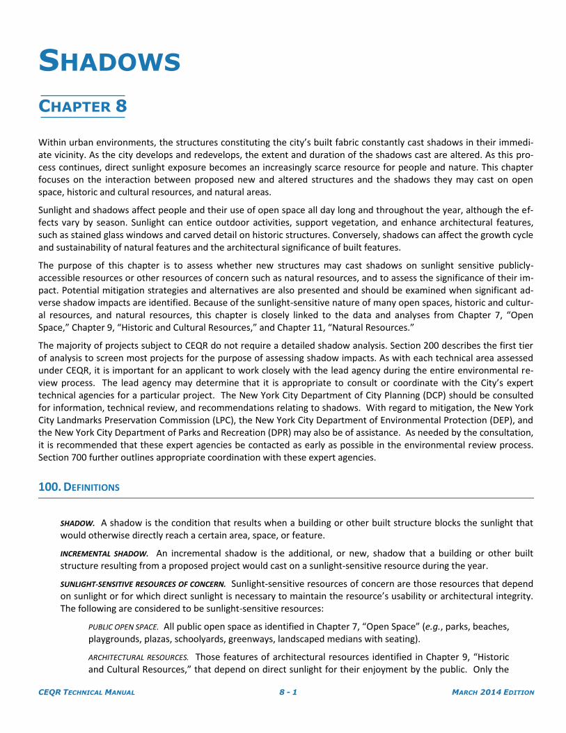
314.2. Determining the “worst case” scenario for shadows
The three-dimensional model of the proposed project must depict a “worst case” scenario for shad-ows from the building resulting from the proposed project. Since the allowable building envelope generally allows for multiple configurations of a building with the same floor area, a “worst case” scenario is constructed for a shadows assessment that combines the worst possible features, in terms of casting shadows, of all possible configurations. This eliminates the need for multiple analyses and would allow for the eventual selection among these possible configurations. This “worst case” sce-nario is illustrated in Figure 8-5. If the proposed project includes special permits or similar actions that relate to the building envelope, the “worst case” should include such allowances or restrictions on the building form. The building envelope depicting the worst case scenario must include the max-imum allowed floor area, all rooftop mechanical equipment, parapets and any other parts of the building. If the proposal contemplates a tower above a base, for example, then the position of the tower on the site would be critical for locating the shadow and the worst case should be illustrated. Generally, where the building is close, or adjacent, to an open space or architectural resource, a bulk-ier building would produce the worst case shadows. Where the building is farther from the open space or resource a taller tower would constitute the worst case. In the case of an expansion to an existing structure, only the effect of the proposed additional space is considered.
WARNING: These printed materials may be out of date. Please ensure you have the current version that can be found on www.nyc.gov/oec.
CEQR TECHNICAL MANUAL 8 - 9 MARCH 2014 EDITION
SHADOWS
FIGURE 8-5 - EXAMPLE OF “WORST CASE” SCENARIO BUILDING ENVELOPE
The example in Figure 8-5 illustrates a hypothetical proposed project of a tower 263 feet in height on a 60 foot high building base with a 40 foot tall mechanical bulkhead on top of the tower and setbacks from the street. The building would have a total height of 303 feet including mechanical space. The “worst case” scenario building envelope includes all por-tions of the site that could be occupied by the building, configured in all possible ways.
314.3. Months of interest and representative days for analysis
The assessment determines whether shadows from the proposed project would fall on a sunlight-sensitive resource at any time throughout the year. Because the direction and length of shadows vary throughout the course of the day and the time of the year, the assessment of shadows is focused on representative times of the year relevant to the use and function of the identified sunlight-sensitive resources.
For the New York City area, the months of interest for an open space resource encompass the grow-ing season (March through October) and one month between November and February (usually De-cember) representing a cold-weather month. Representative days for the growing season are gener-ally the March 21 vernal equinox (or the September 21 autumnal equinox, which is approximately the same), the June 21 summer solstice, and a spring or summer day halfway between the summer sol-stice and equinoxes such as May 6 or August 6 (which are approximately the same). For the cold-weather months, the December 21 winter solstice is usually included to demonstrate conditions dur-ing cold-weather when people who do use open spaces rely most heavily on available sunlight for warmth. Project shadows that reach a sunlight-sensitive resource during any of these months could be of concern. These months and days are also used for assessing shadows on historic or natural sun-light-sensitive resources as they represent the full range of possible shadows.
WARNING: These printed materials may be out of date. Please ensure you have the current version that can be found on www.nyc.gov/oec.

CEQR TECHNICAL MANUAL 8 - 10 MARCH 2014 EDITION
SHADOWS
FIGURE 8-6 - MONTHS OF INTEREST AND REPRESENTATIVE DAYS FOR ANALYSIS
For the representative growing season months, it is not necessary to analyze those months where it is found that no shadow from the project would reach a sunlight-sensitive resource.
For the cold-weather months, if it is found that no shadow from the project would reach a sunlight-sensitive resource on the December 21 analysis day, then the assessment should be performed for a representative day in either November, January, or February in order to confirm that no shadow from the project would reach a sunlight-sensitive resource during any of those months.
314.4. Timeframe window of analysis
The shadow assessment considers those shadows occurring between 1.5 hours after sunrise and 1.5 hours before sunset. Shadows occurring earlier and later are long, move fast, and generally blend with shadows from existing structures. At times outside the timeframe window of analysis, the sun is located near the horizon and the sun’s rays reach the Earth at close to tangential angles diminishing the amount of energy delivered by the sun’s rays and producing shadows that grow in length expo-nentially until the sun reaches the horizon and sets. Because of these conditions, the shadows occur-ring between 1.5 hours before sunset and 1.5 hours after sunrise are not considered significant under CEQR, and their assessment is not required. For the assessment, standard, not daylight savings, time is used. Table A1 (Shadow Factors and Time of Day for Each Shadow Angle, June 21, May 6, March 21, December 21) in the Appendix lists all times within the timeframe window of analysis for four repre-sentative days.
314.5. Conducting the shadow assessment
Once the three-dimensional computer model has been set up, shadow analyses should be performed for each of the representative days for analysis in the months of interest within the timeframe win-dow of analysis, as described in Subsections 314.3 and 314.4.
WARNING: These printed materials may be out of date. Please ensure you have the current version that can be found on www.nyc.gov/oec.

CEQR TECHNICAL MANUAL 8 - 11 MARCH 2014 EDITION
SHADOWS
FIGURE 8-7 - THREE-DIMENSIONAL COMPUTER MODEL SET UP FOR TIER 3
SCREENING ASSESSMENT
Figures 8-7a, 8-7b, 8-7c and 8-7d illustrate the range of shadows that would occur from the proposed building in the example (303 feet tall) on four representative days for analysis. Each figure shows the shadows occurring approximately every 60 minutes from the start of the analysis day (1.5 hours after sunrise) until the end of the analysis day (1.5 hours before sunset).
FIGURE 8-7A - TIER 3 SCREENING ASSESSMENT FOR THE DECEMBER 21 ANALYSIS DAY
The results of the screening assessment for the December 21 analysis day show that shadows from the proposed building would be cast on the sunlight-sensitive resource labeled 1 from the start of the analysis day at 8:51 a.m. and would remain on the re-source until sometime before 10:00 a.m. Shadows from the proposed building would not reach the sunlight-sensitive resource labeled 2 on the analysis day.
WARNING: These printed materials may be out of date. Please ensure you have the current version that can be found on www.nyc.gov/oec.

CEQR TECHNICAL MANUAL 8 - 12 MARCH 2014 EDITION
SHADOWS
FIGURE 8-7B - TIER 3 SCREENING ASSESSMENT FOR THE MARCH 21/SEPTEMBER21
ANALYSIS DAY
The results of the screening assessment for the March 21/September 21 analysis day show that shadows from the proposed building could reach the sunlight-sensitive resource labeled 2 sometime after 2:30 p.m. and would remain on the resource up to the end of the analysis day at 4:29 p.m. Shadows from the pro-posed building would not reach the sunlight-sensitive resource labeled 1 on the analysis day.
FIGURE 8-7C - TIER 3 SCREENING ASSESSMENT FOR THE MAY 6/AUGUST 6
ANALYSIS DAY
The results of the screening assessment for the May 6/August 6 analysis day show that shadows from the proposed building could reach a small portion of the sunlight-sensitive resource labeled 2 sometime between 2:30 p.m. and 4:30 p.m. Shadows from the proposed building would not reach the sunlight-sensitive resource labeled 1 on the analysis day.
WARNING: These printed materials may be out of date. Please ensure you have the current version that can be found on www.nyc.gov/oec.

CEQR TECHNICAL MANUAL 8 - 13 MARCH 2014 EDITION
SHADOWS
FIGURE 8-7D - TIER 3 SCREENING ASSESSMENT FOR THE JUNE 21
ANALYSIS DAY
The results of the screening assessment for the June 21 analysis day show that no shadows from the proposed building could reach either of the sun-light-sensitive resources labeled 1 or 2 on the analysis day.
The Tier 3 screening assessment for the example shows that, in the absence of intervening buildings, shadows from the proposed building would reach two sunlight sensitive resources on three of the representative analysis days, and therefore, a detailed shadow analysis is warranted for those three days. If this assessment determines that no shadows from the proposed project reach any of the sunlight-sensitive resources on any of the representative analysis days, no further assessment for those days is needed. The necessary documentation to support this conclusion illustrating the screen-ing assessment should be provided.
320. DETAILED SHADOW ANALYSIS
A detailed shadow analysis is warranted when the screening analyses described above does not rule out the pos-sibility that project-generated shadows would reach any sunlight-sensitive resources. The detailed shadow analy-sis establishes a baseline condition (future No-Action) that is compared to the future condition resulting from the proposed project (future With-Action) to illustrate the shadows cast by existing or future buildings and distinguish the additional (incremental) shadow cast by the project. The purpose of the detailed analysis is to determine the extent and duration of new incremental shadows that fall on a sunlight-sensitive resource as a result of the pro-posed project. To evaluate the extent and duration of new shadow that would be cast on a sunlight-sensitive re-source as a result of the proposed project, shadows that would exist in the future without the proposed project are also defined. Because existing buildings may already cast shadows on a sun-sensitive resource (or a future building could be expected to cast shadows), the proposed project may not result in additional, or incremental, shadows upon that resource.
WARNING: These printed materials may be out of date. Please ensure you have the current version that can be found on www.nyc.gov/oec.

CEQR TECHNICAL MANUAL 8 - 14 MARCH 2014 EDITION
SHADOWS
FIGURE 8-8 - EFFECTS OF EXISTING BUILDINGS
Figure 8-8 illustrates the effect of a taller existing building beyond the proposed project and a shorter existing build-ing located between the proposed project and the sunlight sensitive resource being analyzed. In this example, both the intervening building and the building beyond the project would cast shadows such that the proposed project does not result in incremental shadow.
321. Future No-Action conditions
The future No-Action conditions include existing buildings or structures plus any identified proposed or planned developments in the No-Action study area. This would include any planned new sun-sensitive re-sources as well.
322. Future With-Action conditions
The future With-Action conditions include the future No-Action conditions plus the new structures and open spaces (if any) created pursuant to the proposed project.
323. Use of three-dimensional computer modeling
In order to carry out the detailed shadow analysis, the three-dimensional computer model used for the previ-ous screening assessment should be augmented by adding the existing and future buildings near the project site that could cast shadows on any of the sunlight-sensitive resources. The added buildings should be repre-sented as accurately as possible including their height, setbacks and any rooftop structures like water tanks or mechanical equipment. If no access to three-dimensional computer modeling software is available, the analy-sis may be carried out manually through a graphic analysis explained in Part B of the Appendix.
WARNING: These printed materials may be out of date. Please ensure you have the current version that can be found on www.nyc.gov/oec.

CEQR TECHNICAL MANUAL 8 - 15 MARCH 2014 EDITION
SHADOWS
FIGURE 8-9 - THREE-DIMENSIONAL COMPUTER MODEL OF FUTURE NO-ACTION CONDITIONS
Figure 8-9 provides an example of shadows that would exist without the project under the future No-Action scenario.
FIGURE 8-10 - THREE-DIMENSIONAL COMPUTER MODEL OF FUTURE WITH-ACTION CONDITIONS
FIGURE 8-10 provides an example of the shadows produced by the proposed project in addition to those cast by existing structures, thus illustrating future With-Action conditions.
WARNING: These printed materials may be out of date. Please ensure you have the current version that can be found on www.nyc.gov/oec.

CEQR TECHNICAL MANUAL 8 - 16 MARCH 2014 EDITION
SHADOWS
324. Performing the detailed analysis
Once the three-dimensional computer model has been set up, shadow analyses should be performed within the timeframe window of analysis only for each of the representative days in the months of interest, where the Tier 3 screening assessment could not rule out the possibility of shadows reaching a sunlight-sensitive re-source.
The shadow attributable to the project is the increment beyond shadows that would be cast in the existing or future No-Action condition. The objective of the detailed analysis is to identify incremental shadows and doc-ument the time at which incremental shadows enter and exit the sunlight-sensitive resource in order to de-termine the total time that incremental shadows are cast on the resource.
325. Documenting the extent and duration of incremental shadows
The results of the detailed shadow analysis should be documented in graphic form and accompanied by a ta-ble summarizing the extent and duration of incremental shadows.
Graphic material documenting the conditions on each of the sunlight-sensitive resources at which an incre-mental shadow occurs should be submitted. The graphic material should include:
The base map illustrating the proposed project site location in relation to the sunlight-sensitive resources.
A site plan of the affected sunlight sensitive resources at an appropriate scale to illustrate incremental shadows on the resources in question that includes:
o Shadows resulting from the future No-Action conditions
o Shadows resulting from the future With-Action conditions
o The incremental shadow on the sunlight-sensitive resource highlighted in a contrasting tone (i.e. red) with its outline delineated.
o In the case of incremental shadows on sunlight-sensitive features of historic resources it may be necessary to provide axonometric drawings documenting conditions on those fea-tures (such as windows) that cannot be assessed from a site plan.
The material should include a graphic scale bar and identify the direction of true north as well as the repre-sentative analysis day and time being illustrated.
The summary table should include the following information for each of the sunlight-sensitive resources on which an incremental shadow occurs:
Name of the sunlight-sensitive resource.
Representative analysis days.
Timeframe window of analysis (1.5 hours after sunrise and 1.5 hours before sunset) for the day analyzed.
Time of incremental shadow entering the sunlight-sensitive resource (enter time).
Time of incremental shadow exiting the sunlight-sensitive resource (exit time).
Total duration of incremental shadow in hours and minutes.
A note confirming that daylight savings time has not been used.
WARNING: These printed materials may be out of date. Please ensure you have the current version that can be found on www.nyc.gov/oec.

CEQR TECHNICAL MANUAL 8 - 17 MARCH 2014 EDITION
SHADOWS
Table 8-1 Analysis summary for the example
Analysis day December 21 March 21/
September 21 May 6 / August 6
June 21
Timeframe window 8:51 a.m. - 2:53 p.m. 7:36 a.m. - 4:29 p.m. 6:27 a.m. - 5:18 p.m. 5:57 a.m. - 6:01 p.m.
Shadow enter - exit times
8:51 a.m. - 9:41 a.m. - - -
Incremental shadow duration
50 min - - -
Shadow enter - exit times
- 2:39 - 4:29 p.m. 3:17 p.m. - 3:48 p.m. -
Incremental shadow duration
- 1 hr 50 min 31 min -
Note: Daylight savings time not used
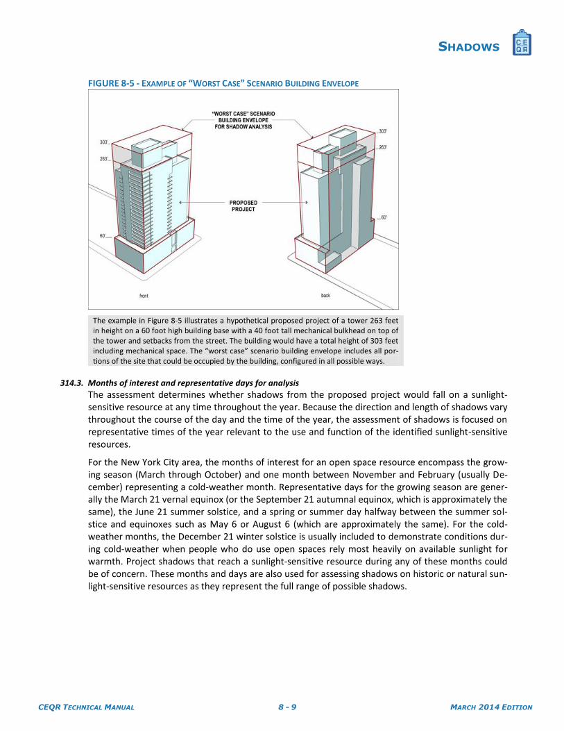
The results of the Tier 3 screening assessment for the example showed that on the June 21 analysis day no shadows from the proposed building could reach any of the sunlight sensitive resources. The Tier 3 screening assessment showed that shadows from the proposed building could reach the sunlight-sensitive resources on the December 21, March 21, and May 6 analysis days. Accordingly, the detailed shadow analysis for the ex-ample focuses only on these months; its results are summarized in Table 8-1 above and illustrated in Figures 8-11 through 8-22 below.
WARNING: These printed materials may be out of date. Please ensure you have the current version that can be found on www.nyc.gov/oec.
CEQR TECHNICAL MANUAL 8 - 18 MARCH 2014 EDITION
SHADOWS
FIGURE 8-11 - DECEMBER 21 - 8:51A.M.
On the December 21 analysis day, the shadow from the proposed building enters the sunlight-sensitive resource labeled 1 at 8:51 a.m. (the start of the analysis day, 1.5 hours after sunrise). Shadows from existing buildings cover large portions of the sunlight-sensitive resource, and only a small portion receives direct sunlight at this time.
FIGURE 8-12 - DECEMBER 21 - 9:08 A.M.
By 9:08 a.m., the extent of the incremental shadow on the sunlight-sensitive resource covers a larger area because the shadows from existing buildings have become shorter.
WARNING: These printed materials may be out of date. Please ensure you have the current version that can be found on www.nyc.gov/oec.

CEQR TECHNICAL MANUAL 8 - 19 MARCH 2014 EDITION
SHADOWS
FIGURE 8-13 - DECEMBER 21 - 9:24 A.M.
By 9:24 a.m., as the sun travels towards the south west and rises higher in the sky, the incremental shadow on the sunlight-sensitive resource has shifted to the northern portion of the resource.
FIGURE 8-14 - DECEMBER 21 - 9:41A.M.
By 9:41a.m., the shadow from the proposed building exits the sunlight-sensitive resource labeled 1. Shadows from the proposed building do not reach the sunlight sensitive resource labeled 2 on this analysis day.
WARNING: These printed materials may be out of date. Please ensure you have the current version that can be found on www.nyc.gov/oec.

CEQR TECHNICAL MANUAL 8 - 20 MARCH 2014 EDITION
SHADOWS
FIGURE 8-15 - MARCH 21 / SEPTEMBER 21 - 2:39 P.M.
On the March 21/September 21 analysis day, the shadow from the pro-posed building enters the sunlight-sensitive resource labeled 2 at 2:39 p.m. Shadows from existing buildings cover the southern half portion of the resource at this time.
FIGURE 8-16 - MARCH 21 / SEPTEMBER 21 - 3:15 P.M.
By 3:15 p.m., the incremental shadow from the proposed building covers the northern portion of the sunlight-sensitive resource effectively eliminat-ing all direct sunlight that the resource would otherwise receive in the ab-sence of the proposed building.
WARNING: These printed materials may be out of date. Please ensure you have the current version that can be found on www.nyc.gov/oec.

CEQR TECHNICAL MANUAL 8 - 21 MARCH 2014 EDITION
SHADOWS
FIGURE 8-17 - MARCH 21 / SEPTEMBER 21 - 3:55 P.M.
By 3:55 p.m., the extent of the incremental shadow from the proposed building has become smaller, but continues to eliminate all direct sunlight that the resource would otherwise receive in the absence of the proposed building.
FIGURE 8-18 - MARCH 21 / SEPTEMBER 21 - 4:29 P.M.
By the end of the analysis day, at 4:29 p.m. (1.5 hours before sunset), the shadow from the proposed building exits the sunlight-sensitive resource. Shadows from existing buildings cover the majority of the resource at this time. Shadows from the proposed building do not reach the sunlight sensi-tive resource labeled 1 on this analysis day.
WARNING: These printed materials may be out of date. Please ensure you have the current version that can be found on www.nyc.gov/oec.

CEQR TECHNICAL MANUAL 8 - 22 MARCH 2014 EDITION
SHADOWS
FIGURE 8-19 - MAY 6 / AUGUST 6 - 3:17 P.M.
On the May 6/August 6 analysis day, the shadow from the proposed build-ing enters the sunlight-sensitive resource labeled 2 at 3:17 p.m. Shadows from existing buildings cover a sliver of the resource at this time and the incremental shadow from the proposed building is virtually imperceptible.
FIGURE 8-20 - MAY 6 / AUGUST 6 - 3:27 P.M.
By 3:27 p.m., the incremental shadow from the proposed building covers a small sliver of the sunlight-sensitive resource.
WARNING: These printed materials may be out of date. Please ensure you have the current version that can be found on www.nyc.gov/oec.

CEQR TECHNICAL MANUAL 8 - 23 MARCH 2014 EDITION
SHADOWS
FIGURE 8-21 - MAY 6 / AUGUST 6 - 3:38 P.M.
By 3:38 p.m., the extent of the incremental shadow from the proposed building has become smaller and shifted towards the east.
FIGURE 8-22 - MAY 6 / AUGUST 6 - 3:48 P.M.
By 3:48 p.m., the shadow from the proposed building exits the sunlight-sensitive resource labeled 2. Shadows from the proposed building do not reach the sunlight sensitive resource labeled 1 on this analysis day.
The graphic material depicts shadow conditions during an instant in time. Because shadows are in constant movement, there may be cases when the graphic material is not sufficient to clearly illustrate how incremen-tal shadows occur on a sunlight-sensitive resource. In order to assess conditions at several times or through-out a certain period, the assessment of shadows for certain complex projects benefits from assembling a
WARNING: These printed materials may be out of date. Please ensure you have the current version that can be found on www.nyc.gov/oec.

CEQR TECHNICAL MANUAL 8 - 24 MARCH 2014 EDITION
SHADOWS
computer animation showing how shadows occur throughout a certain period of time (Subsection 314 in-cludes a list of different software platforms with this capacity). The use of such computer animation might be requested by the lead agency responsible for reviewing the shadow analysis. For guidance on appropriate software to use, the lead agency should consult with DCP.
FIGURE 8-23 - ANIMATION OF SHADOW SWEEP OVER A
PERIOD OF TIME (PLEASE CLICK HERE FOR ANIMATION)
The determination of significance of shadow impacts on a sunlight-sensitive resource is based on (i) the information resulting from the detailed shadow analysis describing the extent and duration of incremental shadows and (ii) an analysis of the resource’s sensitivity to reduced sunlight. The goal of the assessment is to determine whether the ef-fects of incremental shadows on a sunlight-sensitive resource are significant under CEQR.
A shadow impact occurs when the incremental shadow from a proposed project falls on a sunlight-sensitive resource or feature and reduces its direct sunlight exposure. Determining whether this impact is significant or not depends on the extent and duration of the incremental shadow and the specific context in which the impact occurs.
410. OPEN SPACE AND NATURAL RESOURCES
The uses and features of open space or a natural resource indicate its sensitivity to shadows. Shadows occurring during the cold-weather months of interest generally do not affect the growing season of outdoor vegetation; however, their effects on other uses and activities should be assessed. Therefore, this sensitivity is assessed for both (i) warm-weather-dependent features like wading pools and sand boxes, or vegetation that could be affect-ed by a loss of sunlight during the growing season; and (ii) features, such as benches, that could be affected by a loss of winter sunlight.
Uses that rely on sunlight include: passive use, such as sitting or sunning, and active use, such as using playfields or paved courts, gardening, or playing in children's wading pools and sprinklers. Where lawns are actively used, the turf requires extensive sunlight. Vegetation requiring direct sunlight includes tree canopies, flowering plants, and plots in community gardens. Generally, four to six hours a day of sunlight, particularly in the growing season, is a minimum requirement. Consequently, the assessment of an open space's sensitivity to increased shadows fo-cuses on identifying the existing conditions of its facilities, plantings, and uses, and the sunlight requirements for each.
400. DETERMINING IMPACT SIGNIFICANCE
WARNING: These printed materials may be out of date. Please ensure you have the current version that can be found on www.nyc.gov/oec.

CEQR TECHNICAL MANUAL 8 - 25 MARCH 2014 EDITION
SHADOWS
For open space resources within the jurisdiction of the Department of Parks and Recreation (DPR), DPR should be consulted in order to verify existing sun-sensitive areas and obtain information on current recreational and pas-sive activities in sunlit areas of the park, as well as planned capital projects that may result in a change to existing sunlight-sensitive features.
Although shadows on project-generated open space are not considered significant under CEQR, the assessment of shadows on project-generated open space should be conducted and documented with the same level of detail as other sunlight-sensitive open space resources when such project generated open space is included qualitatively as part of a detailed analysis required Chapter 7, “Open Space.”
411. Assessment
A site plan and inventory of the features that constitute the open space or natural resource as well as a survey detailing existing conditions, quality, and levels of use of the open space are needed to determine the signifi-cance of the shadow cast in the future With-Action. The majority of this information may be already available through the analysis in Chapter 7, “Open Space,” and Chapter 11, “Natural Resources,” respectively, and should be used as part of the assessment.
The site plan should show the boundary and layout of the open space or natural resource, the location of vegetation and sunlight-sensitive features, its built structures, and other features of the open space, including paved areas. The site plan should identify the direction of true north and include a graphic scale bar, and may be complemented by an aerial photograph and photographs of the open space features. Figure 8-24 below provides an example of an open space site plan.
To carry out the assessment, the composite shadows obtained from the detailed shadows analysis are over-laid on the open space site plan in order to determine the areas and sunlight-sensitive features of the open space that would be cast in the project’s incremental shadow. The assessment is performed for all the months of interest when incremental shadows are predicted to be cast on the open space or natural resource.
In the area that would be cast in the project's incremental shadow, it may be necessary to inventory vegeta-tion, noting species, caliper, height, and age. Such inventory may be presented in the site plan. It may be ad-visable to use the services of a recreation planner, landscape architect, or horticulturist to inventory, survey, and assess the sensitivity of the open space to shadows. When the sunlight-sensitive resource is under the ju-risdiction of DPR, determinations about the relative shade tolerance of existing vegetation should be re-viewed by DPR.
If the open space or natural resource supports activities that rely on sunlight and would be cast in project shadow, it is also appropriate to survey its use. This should be done on a sunny day in the spring, summer, or fall, preferably on the weekend or at the time of peak use. Based on this work, the activities, plants, or other facilities in the open space that need sunlight and may be affected by project shadows should be identified and may be noted in the site plan. To the extent possible, the acceptable and minimum amounts of daily sun-light required for the plants or activities should be estimated.
412. Estimating the relative loss of sunlight from incremental shadows
Where the incremental shadows from the project fall on sunlight-sensitive features or uses, additional analy-sis is required to assess the loss of sunlight relative to sunlight that would be available without the project. It is necessary to estimate shadow patterns on the affected area of the open space or resource throughout the day in order to assess how shadows, both incremental shadows from the project and shadows cast by existing structures, affect the sensitive features. It should also be assessed whether these sensitive features are al-ready subject to substandard sunlight conditions in the absence of additional incremental shadows from the project. The assessment should consider all shadows on the portion of the sunlight-sensitive features or uses affected by the project's incremental shadow throughout the day. The analysis should be undertaken for each of the months of interest where the effects of incremental shadows from the project could be significant.
WARNING: These printed materials may be out of date. Please ensure you have the current version that can be found on www.nyc.gov/oec.

CEQR TECHNICAL MANUAL 8 - 26 MARCH 2014 EDITION
SHADOWS
It should be noted that the shade created by trees and other natural features is not considered to be shadow of concern for the impact analysis; however, incremental shadow on a tree-shaded environment may create a significant impact as the incremental shadow is not redundant with tree shade, and the tree canopy may be considered a sunlight-sensitive resource.
Consideration of the inventory of available open space resources within the Open Space study area outlined in Chapter 7, “Open Space,” may be helpful in assessing the significance of the loss of sunlight for active or passive recreational uses. For example, if many of the parks in the study area already have shadows on simi-lar sun sensitive features, the additional loss of sunlight in parks may be more critical.
Some open spaces contain facilities that are not sensitive to sunlight. These are usually paved; do not contain sitting areas, vegetation, or unusual or historic plantings that necessitate sunlight; and do not accommodate active uses. Incremental shadows on these portions of an open space resource should be documented and disclosed but are not generally considered significant under CEQR.
The significance of shadows cast on an open space should be closely examined in relation to the open space’s utilization rates, as discussed in Chapter 7, “Open Space,” in order to determine the potential for the shadows to affect the times of day the space is commonly used. This is particularly important when shadows are cast on open spaces that fall within an area without similar sunlit resources. Estimating the loss of sunlight on paved or hardscape open spaces that accommodate active uses–such as basketball and tennis courts–may be determined based on how the active area is used by the community and the utilization rate of such spaces as described and assessed in Chapter 7, “Open Space.” While this loss of sunlight is generally not considered significant, the lead agency should consider how the area is used by the community and the utilization rate of such spaces as described and assessed in Chapter 7, “Open Space,” in order to determine the significance of the incremental shadow.
420. HISTORIC RESOURCES
The shadow sensitivity of the sunlight-sensitive features of an historic structure depends on its design and setting. If any of the characteristics or elements that make the resource historically significant depend on sunlight, it is necessary to inventory those features to determine their sensitivity to a reduction in sunlight. The assessment should consider the specific context in which the incremental shadow occurs and provide an analysis of how other shadows from existing structures affect the sunlight-sensitive features of the historic resource throughout the day.
Additional guidance regarding the identification of sunlight-sensitive features and assessment of stained glass windows can be found in the National Park Service (NPS) Preservation Brief 17, “Architectural Character: Identify-ing the Visual Aspects of Historic Buildings as an Aid to Preserving Their Character,” and NPS Preservation Brief 33: “The Preservation and Repair of Historic Stained and Leaded Glass.”
421. Assessment
The assessment of shadows on an historic resource focuses only on those features or portions of the historic resource that are sunlight-sensitive and can be enjoyed by the public. Only the incremental shadow duration on the sun-sensitive features of the historic resource is of concern under CEQR. The assessment of shadows on an historic resource requires a site plan and inventory of the sunlight-sensitive features. The inventory discusses the historic significance of the affected features and how the features are enjoyed by the public, in-cluding views from streets and other publicly accessible places. The sunlight-sensitive features should be de-scribed in detail and illustrated as necessary with drawings and/or photographs, including axonometric draw-ings when the affected features cannot be assessed on a site plan. The majority of this information may be al-ready available in Chapter 9, “Historic and Cultural Resources,” and should be used as part of the assessment.
The inventory of sunlight-sensitive features may also be determined by checking the LPC designation report for LPC designated properties, scenic landmarks, and (publicly accessible) interiors, or the State/National Reg-
WARNING: These printed materials may be out of date. Please ensure you have the current version that can be found on www.nyc.gov/oec.

CEQR TECHNICAL MANUAL 8 - 27 MARCH 2014 EDITION
SHADOWS
ister nomination form for State/National Register listed properties. The State/National Register listings com-prise the entirety of the building and/or structure and do not distinguish between publicly and privately ac-cessible interiors. Building interiors that are State/National Register listed or eligible, or LPC designated, are included in the types of resources that may receive potential shadow impacts. All other interiors are not con-sidered under this type of analysis. Consult with the staff of the LPC to confirm presence or absence of sun-light-sensitive features on LPC and S/NR eligible properties.
430. DETERMINING IMPACT SIGNIFICANCE
The scenarios illustrated below provide general guidelines for determining impact significance and supplement the considerations described in Sections 410 and 420. As with every technical area, each project must be consid-ered on its own merits, taking into account its unique circumstances. For instance, the precise location of the in-cremental shadow within the sunlight-sensitive resource (or the presence of well-lit resources in close proximity to the affected resource) may be highly relevant because the incremental shadow may affect specific features that are key to the character, use, survival, or enjoyment of the sun-sensitive resource. For the purposes of CEQR, the determination of impact significance in ambiguous cases should be done in a conservative manner. In all cas-es, the rationale for the determination of impact significance should be clearly presented in the resulting envi-ronmental review document.
In general, an incremental shadow is not considered significant when its duration is no longer than 10 minutes at any time of year and the resource continues to receive substantial direct sunlight. A significant shadow impact generally occurs when an incremental shadow of 10 minutes or longer falls on a sunlight sensitive resource and results in one of the following:
VEGETATION
A substantial reduction in sunlight available to a sunlight-sensitive feature of the resource to less than the minimum time necessary for its survival (when there was sufficient sunlight in the future without the project).
A reduction in direct sunlight exposure where the sensitive feature of the resource is already subject to substandard sunlight (i.e., less than minimum time necessary for its survival).
HISTORIC AND CULTURAL RESOURCES
A substantial reduction in sunlight available for the enjoyment or appreciation of the sunlight-sensitive features of an historic or cultural resource.
OPEN SPACE UTILIZATION
A substantial reduction in the usability of open space as a result of increased shadows (cross reference with information provided in Chapter 7, “Open Space,” regarding anticipated new users and the open space’s utilization rates throughout the affected time periods).
FOR ANY SUNLIGHT-SENSITIVE FEATURE OF A RESOURCE
Complete elimination of all direct sunlight on the sunlight-sensitive feature of the resource, when the complete elimination results in substantial effects on the survival, enjoyment, or, in the case of open space or natural resources, the use of the resource.
In determining impact significance, it is appropriate to consult with the government agency under which jurisdic-tion of the affected sunlight-sensitive resource falls, including DPR, LPC, or other agencies, as required. Below is a non-exclusive list of examples of significant impacts caused by incremental shadows.
EXAMPLES
A chapel attached to a 19th century cathedral that is designated as a New York City Landmark, listed in the State and National Register of Historic Places, and a designated National Historic Landmark would receive incremental shadows on some of its stained glass windows from a proposed building. The review finds that
WARNING: These printed materials may be out of date. Please ensure you have the current version that can be found on www.nyc.gov/oec.

CEQR TECHNICAL MANUAL 8 - 28 MARCH 2014 EDITION
SHADOWS
the interiors of such religious structures are important to their character and that the qualities that the stained glass windows impart to the interior are a major part of the overall architectural intent in this church and part of the Gothic Revival style. After assessing the extent and duration of the incremental shadow, it is determined that the darkening would occur for a substantial part of the day on the stained glass windows and would constitute a significant impact. In addition, the impact would occur regardless of whether the ca-thedral holds services when the incremental shadow is cast.
A 19th century scenic landmark that is designated as a New York City Landmark, listed in the State and Na-tional Register of Historic Places, and a designated National Historic Landmark would receive incremental shadow from a proposed building. After taking into account the time of the year, shadow duration during the day, and the number of days a years of the incremental shadow, the review finds (i) that the park is sen-sitive to the incremental shadows because they detract from the experience of a seemingly naturalistic envi-ronment that was part of the design intent of the park; (ii) that the addition of incremental shadow would endanger the rare and exotic plant species that were part of its original horticultural design; and (iii) that the incremental shadows could therefore constitute a significant impact.
A 20th century office building that is designated a New York City Landmark that also has a publicly accessible interior garden atrium that is designated as a New York City interior landmark would receive incremental shadow from a proposed structure. The full height atrium is considered an outstanding and unique example of an “urban greenhouse.” After taking into account the extent and duration of the incremental shadow, the review finds that the incremental shadow that would be cast on the atrium would detract from the pub-lic’s appreciation and enjoyment of the space and could therefore result in a significant shadow impact.
DETERMINING IMPACT SIGNIFICANCE FOR THE EXAMPLE
The results of the example’s detailed shadow analysis document the extent and duration of the in-cremental shadows that the proposed project would cast on two sunlight-sensitive resources, summa-rized in Table 8-1 and illustrated in Figures 8-11 through 8-22.
SUNLIGHT-SENSITIVE RESOURCE EXAMPLE 1:
Incremental shadows from the proposed building would reach the sunlight-sensitive resource la-beled 1 only on the December 21 analysis day. No incremental shadows from the proposed build-ing would reach the resource on other analysis days.
On the December 21 analysis day, incremental shadows from the proposed building would enter the sunlight-sensitive resource at 8:51 a.m. (the start of the analysis day) and would exit the re-source at 9:41 a.m., remaining in the resource for a total of 50 minutes.
At the start of the analysis day at 8:51 a.m. (Figure 8-11) the resource is almost covered in shad-ows from both the proposed building and from existing buildings. By 9:08 a.m. (Figure 8-12), both shadows have shifted north allowing sunlight to reach the south east corner of the resource where the playground is located (see site plan in Figure 8-23). By 9:24 (Figure 8-13), both shad-ows have shifted further north and to the east allowing sunlight to reach approximately half of the resource, including a large portion of the central lawn area. By 9:41 a.m. (Figure 8-14), the in-cremental shadow exits the resource and although the existing building to the east casts some shadow on it, sunlight reaches the majority of the resource.
WARNING: These printed materials may be out of date. Please ensure you have the current version that can be found on www.nyc.gov/oec.

CEQR TECHNICAL MANUAL 8 - 29 MARCH 2014 EDITION
SHADOWS
FIGURE 8-24 – ILLUSTRATED SITE PLAN FOR THE SUNLIGHT-SENSITIVE RESOURCE LABELED 1
In conclusion, the overall duration of the incremental shadows cast on the sunlight-sensitive re-source would be short and occur during a small portion of the day. Upon examination of the site plan in Figure 8-24, the incremental shadows would not affect areas of the resource with sensi-tive uses such as the playground, nor would affect the vegetation as December is not part of the growing season. Therefore, the proposed building would not result in a significant shadow impact on the sunlight-sensitive resource labeled 1.
SUNLIGHT-SENSITIVE RESOURCE EXAMPLE 2:
Incremental shadows from the proposed building would reach the sunlight-sensitive resource la-beled 2 only on the March 21/September 21 and May 6/August 6 analysis days (see Figures 8-16 through 8-20). No incremental shadows from the proposed building would reach the resource on other analysis days.
Even though a site plan for this resource is not available, it is known that the resource contains non shade-tolerant vegetation and sunlight-sensitive uses such as benches.
On the May 6/August 6 analysis day, incremental shadows from the proposed building would en-ter the sunlight-sensitive resource at 3:17 p.m. and would exit the resource at 3:48 p.m., remain-ing in the resource for a total of 31 minutes. As discussed and illustrated in Figures 8-19 to 8-22, the incremental shadow from the proposed building would cover only a small portion of the re-source and the majority of the resource would continue to receive direct sunlight during this pe-riod of time. Given the marginal extent and relatively short duration of the incremental shadow on this analysis day, the incremental shadow is not considered significant.
On the March 21/September 21 analysis day, incremental shadows from the proposed building would enter the sunlight-sensitive resource at 2:39 p.m. (the start of the analysis day) and would exit the resource at 4:29 p.m., remaining in the resource for a total of 1 hour and 50 minutes.
WARNING: These printed materials may be out of date. Please ensure you have the current version that can be found on www.nyc.gov/oec.
CEQR TECHNICAL MANUAL 8 - 30 MARCH 2014 EDITION
SHADOWS
As discussed and illustrated in Figures 8-15 to 8-18, the incremental shadow from the proposed building would substantially reduce and eventually eliminate the sunlight that would reach the resource during a relatively long period of time. The shadow would affect the resource’s vegeta-tion as March is part of the growing season and would affect sunlight-sensitive uses in the re-source. Therefore, the proposed building would result in a significant shadow impact on the sun-light-sensitive resource labeled 2.
Where a significant impact is identified, potential mitigation strategies must be assessed to reduce or eliminate, to the greatest extent practicable, the effects caused by incremental shadows.
In all cases, additional mitigation strategies that involve modifications to the height, shape, size or orientation of the proposed building may be explored and include:
The reorientation of building bulk to avoid incremental shadow on sunlight-sensitive features of the open space, natural or historic resource.
The reduction of the overall height of the project.
The use of alternative technologies that may reduce the height of the project and reduce shadow impacts (e.g., the use of dry cooling towers vs. wet cooling towers).
The relocation of the project to a different site, when appropriate.
For open space resources, the types of mitigation that may be appropriate include relocating sunlight-sensitive fea-tures within an open space to avoid sunlight loss; relocating, replacing or monitoring vegetation for a set period of time; undertaking additional maintenance to reduce the likelihood of species loss; or providing for replacement facili-ties on another nearby site. Other potential mitigation strategies include the redesign or reorientation of the open space site plan to provide for replacement facilities, vegetation, or other features. Where the affected open space is a city park, it is appropriate for the lead agency to coordinate mitigation options with the Department of Parks and Rec-reation (DPR). The lead agency may also wish to coordinate with DPR as an expert agency on open spaces that are not city parks.
For historic resources, potential mitigation strategies include the use of artificial lighting to simulate the effect of sun-light on features such as stained glass windows. Where the affected historic resource is a New York City landmark, a LPC-calendared or eligible property, or a National Register listed or eligible structure or property, it is appropriate for the lead agency to coordinate mitigation options with LPC. The lead agency may also wish to coordinate with LPC as an expert agency on historic resources that are not NYC landmarks.
Potential mitigation strategies to reduce or eliminate a significant shadow impact on natural resources may be coordi-nated with the Department of Environmental Protection (DEP).
These mitigation strategies can become alternatives to be analyzed in accordance to the project’s goals and objectives.
Where a significant shadow impact is identified, potential alternatives to reduce or eliminate significant impacts should be explored, including:
The reorientation of building bulk to avoid incremental shadow on sunlight-sensitive features of the open space, natural or historic resource.
The reduction of the overall height of the project.
The use of alternative technologies where substituting one technology for another may reduce the height of the project and reduce shadow impacts (e.g., the use of dry cooling towers vs. wet cooling towers).
500. MITIGATION
600. ALTERNATIVES
WARNING: These printed materials may be out of date. Please ensure you have the current version that can be found on www.nyc.gov/oec.

CEQR TECHNICAL MANUAL 8 - 31 MARCH 2014 EDITION
SHADOWS
The relocation of the project to a different site, when appropriate.
710. REGULATIONS AND STANDARDS
There are no specific city, state, or federal statutory regulations or standards governing the analysis and assess-ment of shadows.
720. APPLICABLE COORDINATION
Coordination with DCP is required when it is an involved agency and the project includes an action subject to ap-proval by the City Planning Commission. The lead agency should coordinate with those agencies that identify, op-erate, or have jurisdiction over the sunlight-sensitive resources identified in this chapter. The assessment of shad-ow impacts on a sunlight-sensitive resource and the development of mitigation strategies should be coordinated with the appropriate agency with jurisdiction over the resource. Mitigation would typically require the approval or commitment of such agency. Agencies typically consulted include the Department of Parks and Recreation for sunlight-sensitive open space resources, the Landmarks Preservation Commission for historic and cultural sun-light-sensitive resources, and the Department of Environmental Protection for sunlight-sensitive natural re-sources.
730. LOCATION OF INFORMATION
The Department of City Planning maintains copies of the Sanborn maps, Fire Insurance Underwriters maps, and tax maps for the entire city. These sources are also available online (except Sanborn maps) and in local public libraries. City Maps are available for viewing in the Borough President's office in each borough and at the Department of City Planning.
New York City Department of City Planning 22 Reade Street New York, NY 10007 www.nyc.gov/dcp Online publications: http://www.nyc.gov\html\dcp\html\subcats\products.shtml Bookstore: www.nyc.gov/html/dcp/html/pub/publist.shtml
The Department of Parks and Recreation maintains a database of the City’s public open spaces available online. For additional information see also Section 730 (Location of Information) of Chapter 7, “Open Space,” for a detailed list of informational resources regarding open space.
New York City Department of Parks and Recreation The Arsenal 830 Fifth Avenue New York, NY 10065 www.nyc.gov/parks
The Landmarks Preservation Commission maintains a database of the City’s historic and cultural landmarks with a variety of information available online including historic district maps and designation reports.
New York City Landmarks Preservation Commission Municipal Building 1 Centre Street, 9th Floor New York, NY 10007 www.nyc.gov/landmarks
700. REGULATIONS AND COORDINATION
WARNING: These printed materials may be out of date. Please ensure you have the current version that can be found on www.nyc.gov/oec.

CEQR TECHNICAL MANUAL 8 - 32 MARCH 2014 EDITION
SHADOWS
New York City Department of Environmental Protection
59-17 Junction Boulevard, 13th Floor Flushing, NY 11373 www.nyc.gov/dep
WARNING: These printed materials may be out of date. Please ensure you have the current version that can be found on www.nyc.gov/oec.