warm sector air
17
Chapter 14, Sec. 14.1 & 14.2 (emphasizing Mid-latitude Cyclone) EAS270_Ch14_Storms_A.odp JDW, EAS U.Alberta, last mod. 29 Nov. 2016 comma-shaped cloud warm sector air Fig 14.3 Mid-latitude cyclone ● synoptic scale ● initiated & supported by upper divergence ● deep, tilted system ● baroclinic ● energy derived from temperature contrast across polar front Sec. 14.1 and Table 14.1 give an idealized classification of atmospheric circulation systems (on the meso- and synoptic- scales: shallow vs. deep, barotropic vs. baroclinic, tilted vs. vertically-stacked, cold vs. warm core
Transcript of warm sector air

Chapter 14, Sec. 14.1 & 14.2 (emphasizing Mid-latitude Cyclone) EAS270_Ch14_Storms_A.odpJDW, EAS U.Alberta, last mod. 29 Nov. 2016
comma-shaped cloud
warm sector air
Fig 14.3
Mid-latitude cyclone
● synoptic scale
● initiated & supported by upper divergence
● deep, tilted system
● baroclinic
● energy derived from temperature contrast
across polar front
Sec. 14.1 and Table 14.1 give an idealized
classification of atmospheric circulation
systems (on the meso- and synoptic- scales:
shallow vs. deep, barotropic vs. baroclinic,
tilted vs. vertically-stacked, cold vs. warm
core
John Wilson
John Wilson
John Wilson
John Wilson
John Wilson
John Wilson
John Wilson
John Wilson
John Wilson
John Wilson
John Wilson
John Wilson
John Wilson
John Wilson
John Wilson
John Wilson
John Wilson
John Wilson
John Wilson
John Wilson
John Wilson
John Wilson
John Wilson
John Wilson
John Wilson
John Wilson
John Wilson
John Wilson
John Wilson
John Wilson
John Wilson
John Wilson
John Wilson
John Wilson
John Wilson
John Wilson
John Wilson
John Wilson
John Wilson
John Wilson
John Wilson
John Wilson
John Wilson
John Wilson
John Wilson
John Wilson
John Wilson
John Wilson
John Wilson
John Wilson
John Wilson
John Wilson
John Wilson

Sec 14.2 Midlatitude cyclone – illustrating tilt 2/17
Fig 14.4 a,b
● surface low in Manitoba is positioned
beneath the exit region of the trough
upwind (which runs through
Saskatchewan)
young storm
old (occluded) storm
● can sometimes identify
"families" of storms along the
polar front, in different stages
of the storm life cycle
symbol on Cdn charts for a TROWAL
John Wilson
John Wilson
John Wilson
John Wilson
John Wilson
John Wilson
John Wilson
John Wilson
John Wilson
John Wilson
John Wilson
John Wilson
John Wilson
John Wilson
John Wilson
John Wilson
John Wilson
John Wilson
John Wilson
John Wilson
John Wilson
John Wilson
John Wilson
John Wilson
John Wilson
John Wilson
John Wilson
John Wilson
John Wilson
John Wilson
John Wilson
John Wilson
John Wilson
John Wilson
John Wilson
John Wilson
John Wilson
John Wilson
John Wilson
John Wilson
John Wilson
John Wilson
John Wilson
John Wilson
John Wilson
John Wilson
John Wilson
John Wilson
John Wilson
John Wilson
John Wilson
John Wilson
John Wilson
John Wilson
John Wilson
John Wilson
John Wilson
John Wilson
John Wilson
John Wilson
John Wilson
John Wilson
John Wilson
John Wilson
John Wilson
John Wilson
John Wilson
John Wilson
John Wilson
John Wilson
John Wilson
John Wilson
John Wilson
John Wilson
John Wilson
John Wilson
John Wilson
John Wilson

Cutoff low 3/17
Cutoff low; synoptic scale cold pool of air trapped on equator-ward side of the polar
jetstream; vertically stacked; slow-moving; persistent cloud & precip.
Cutoff high – warm air on polar side of front; prevailing fine weather
Fig 14.5
JETSTREAM

Sec 14.2.1 Polar Front Theory for life cycle of a mid-latitude storm 4/17
Fig 14.7
● Divergence aloft lowers Psfc
● cyclonic wind initiated
● distinct cold and warm
fronts result, joining at a
"kink" or "wave"
● ascent of the warm air over
cold liberates PE
● frontal cloud & precip
● Wind shear across QS front
● Store of gravitational
potential energy (PE)
● Mature "open wave
stage"
● lower central pressure,
stronger winds
● well defined warm
sector
● vigorous convection
John Wilson
John Wilson
John Wilson
John Wilson
John Wilson
John Wilson
John Wilson
John Wilson
John Wilson
John Wilson
John Wilson
John Wilson
John Wilson
John Wilson
John Wilson
John Wilson
John Wilson
John Wilson
John Wilson
John Wilson
John Wilson
John Wilson
John Wilson
John Wilson
John Wilson
John Wilson
John Wilson
John Wilson
John Wilson
John Wilson
John Wilson
John Wilson
John Wilson
John Wilson
John Wilson
John Wilson
John Wilson
John Wilson

Fig 14.7
● Occluded low (located
N of front & jetstream)
● Mature storm, even lower
central pressure
● Stronger winds
● Cold front converging on
warm front narrows the
warm sector
● Occlusion begins – cold front
converging on warm front
forces warm sector air aloft
(Trough of warm air aloft –
"TROWAL")
● Reduced airmass contrast at
the surface
● Surface warm sector air now
remote from the storm core
Sec 14.2.1 Life cycle of a mid-latitude storm (after Bjerknes & Solberg 1922) 5/17
John Wilson
John Wilson
John Wilson
John Wilson
John Wilson
John Wilson
John Wilson
John Wilson
John Wilson
John Wilson
John Wilson
John Wilson
John Wilson
John Wilson
John Wilson
John Wilson
John Wilson
John Wilson
John Wilson
John Wilson

Cross section north of the storm centre
Cross section south of the storm centre
nominal direction of travel
cloudless
Sec 14.2.1 Life cycle of mid-latitude storm (drawings of Bjerknes & Solberg 1922) 6/17
Fig 14.6a
John Wilson
John Wilson
John Wilson
John Wilson
John Wilson
John Wilson
John Wilson
John Wilson
John Wilson
John Wilson
John Wilson
John Wilson
John Wilson
John Wilson
John Wilson
John Wilson
John Wilson
John Wilson
John Wilson
John Wilson
John Wilson
John Wilson
John Wilson
John Wilson
John Wilson
John Wilson
John Wilson
John Wilson
John Wilson
John Wilson
John Wilson
John Wilson
John Wilson
John Wilson
John Wilson
John Wilson
John Wilson
John Wilson
John Wilson
John Wilson
John Wilson
John Wilson
John Wilson
John Wilson
John Wilson
John Wilson
John Wilson
John Wilson
John Wilson
John Wilson
John Wilson
John Wilson
John Wilson
John Wilson
John Wilson
John Wilson
John Wilson
John Wilson
John Wilson
John Wilson

Ch14. Life cycle of a mid-latitude storm (after Bjerknes & Solberg 1922) 7/17
J. Bjerknes
Bjerknes developed this paradigm for the storm's life cycle on the basis of (mostly) surface observations
Fig 14.6b
● cyclone lifetime a few days to over a week

Storm life cycle (example): wind shear across front 8/17
CMC 850 hPa analysis 12Z Sat 28 Oct. 2006
John Wilson
John Wilson
John Wilson
John Wilson
John Wilson
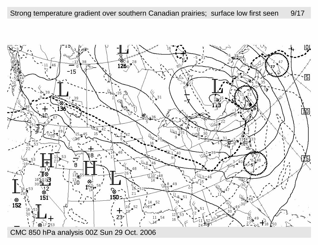
Strong temperature gradient over southern Canadian prairies; surface low first seen 9/17
CMC 850 hPa analysis 00Z Sun 29 Oct. 2006
John Wilson
John Wilson
John Wilson
John Wilson
John Wilson
John Wilson
John Wilson
John Wilson
John Wilson
John Wilson
John Wilson
John Wilson
John Wilson
John Wilson
John Wilson
John Wilson
John Wilson
John Wilson
John Wilson
John Wilson
John Wilson
John Wilson
John Wilson
John Wilson
John Wilson
John Wilson
John Wilson
John Wilson
John Wilson
John Wilson
John Wilson
John Wilson
John Wilson
John Wilson
John Wilson
John Wilson
John Wilson
John Wilson
John Wilson
John Wilson
John Wilson
John Wilson
John Wilson
John Wilson
John Wilson
John Wilson
John Wilson
John Wilson
John Wilson
John Wilson
John Wilson
John Wilson
John Wilson
John Wilson
John Wilson
John Wilson
John Wilson
John Wilson
John Wilson
John Wilson
John Wilson
John Wilson
John Wilson
John Wilson
John Wilson
John Wilson
John Wilson
John Wilson
John Wilson
John Wilson
John Wilson
John Wilson
John Wilson
John Wilson
John Wilson
John Wilson
John Wilson
John Wilson
John Wilson
John Wilson
John Wilson
John Wilson
John Wilson
John Wilson
John Wilson
John Wilson
John Wilson
John Wilson
John Wilson
John Wilson
John Wilson
John Wilson
John Wilson
John Wilson
John Wilson
John Wilson
John Wilson
John Wilson
John Wilson
John Wilson
John Wilson
John Wilson
John Wilson
John Wilson
John Wilson
John Wilson
John Wilson
John Wilson
John Wilson
John Wilson
John Wilson
John Wilson
John Wilson
John Wilson
John Wilson
John Wilson
John Wilson
John Wilson
John Wilson
John Wilson
John Wilson
John Wilson
John Wilson
John Wilson
John Wilson
John Wilson
John Wilson
John Wilson
John Wilson
John Wilson
John Wilson
John Wilson
John Wilson
John Wilson
John Wilson
John Wilson
John Wilson
John Wilson
John Wilson
John Wilson
John Wilson
John Wilson
John Wilson
John Wilson
John Wilson
John Wilson
John Wilson
John Wilson
John Wilson
John Wilson
John Wilson
John Wilson
John Wilson
John Wilson
John Wilson
John Wilson
John Wilson
John Wilson
John Wilson

Strong temperature gradient over southern Canadian prairies; “kink” accentuating? 10/17
CMC 850 hPa analysis 12Z Sun 29 Oct. 2006
John Wilson
John Wilson
John Wilson

Low pressure along the frontal zone – wind shear across the zone in Montana/N. Dakota 11
CMC 850 hPa analysis 00Z Mon 30 Oct. 2006
Central height 135 dam

Storm deepened – open wave configuration – will run along & displace the frontal zone 12/17
CMC 850 hPa analysis 12Z Mon 30 Oct. 2006
Central height 130 dam
John Wilson
John Wilson
John Wilson
John Wilson

Cold air wrapping towards SE on the western flank 13/17
CMC 850 hPa analysis 00Z Tues 31 Oct. 2006
Central height 130 dam
John Wilson
John Wilson
John Wilson
John Wilson
John Wilson
John Wilson
John Wilson
John Wilson
John Wilson
John Wilson
John Wilson
John Wilson
John Wilson
John Wilson
John Wilson
John Wilson
John Wilson
John Wilson
John Wilson
John Wilson
John Wilson
John Wilson
John Wilson
John Wilson
John Wilson
John Wilson
John Wilson
John Wilson
John Wilson
John Wilson
John Wilson
John Wilson
John Wilson
John Wilson
John Wilson
John Wilson
John Wilson
John Wilson
John Wilson
John Wilson

CMC 850 hPa analysis 12Z Tues 31 Oct. 2006
Cold air wrapping towards SE on the western flank 14/17
Central height 123 dam
John Wilson
John Wilson
John Wilson
John Wilson
John Wilson
John Wilson
John Wilson
John Wilson
John Wilson
John Wilson
John Wilson
John Wilson
John Wilson
John Wilson
John Wilson

Storm now displaced away from warm sector zone – occluded phase 15/17
CMC 850 hPa analysis 00Z Wed 1 Nov. 2006
Central height 117 dam
John Wilson
John Wilson
John Wilson
John Wilson

Sec 14.2.2 Baroclinic wave theory of cyclogenesis (cyclone initiation) & development 16/17
Fig 14.8
(over a stationary front)
Δ( f c + ζ r )
Δ t= − D ( f c + ζr )
Δ ζr
Δ t= − D f c
Favourable conditions for cyclogenesis where there is strong surface temperature contrast (e.g. at
or near high latitude coastlines in winter). Strong latitudinal temperature gradient tends to result in
large amplitude Rossby waves, i.e. strongly meridional flow, and vigorous storms: thus storms are
stronger in winter
1) divergence aloft removes mass off the column 2) resulting in ascent and a surface low
3) and surface convergence, strengthening temperature gradients 4) rotating storm winds
Surface convergence implies D<0, so rhs is positive: increasing cyclonic vorticity
suppose initially no rotation
John Wilson
John Wilson
John Wilson
John Wilson
John Wilson
John Wilson
John Wilson
John Wilson
John Wilson
John Wilson
John Wilson
John Wilson
John Wilson
John Wilson
John Wilson
John Wilson
John Wilson
John Wilson
John Wilson

Fig 14.9
Now known – an extra-tropical cyclone entails coordinated
3-dimensional pattern, i.e. surface manifestation of the
storm links with a "wave" aloft. Feedbacks operate, e.g. div.
aloft drops sfc P, increasing sfc winds, increasing sfc
convergence, increasing vertical motion...
● Existence of planetary waves is verified by analysis of more complete equations of motion on a rotating planet
● Those equations of motion also indicate existence of a different type of wave, the "baroclinic" wave (short wave)
An extra-tropical cyclone requires "tilt" if it is to have longevity – aloft, the low (or trough) on the isobaric surface lies upwind (nominally, northwest) of the surface low, rather than directly above it
deep "vertically stacked" low
deep tilted low
● We earlier encountered the
Rossby wave" (longwave) –
and gave it theoretical
justification in terms of a
simple paradigm –
conservation of absolute
vorticity along the wave
Sec 14.2.2 Baroclinic wave theory of cyclogenesis (cyclone initiation) & development 17/17