WALKING TRAIL - City of Kingston
32
MORDIALLOC a pocket guide WALKING TRAIL scan for extra features
Transcript of WALKING TRAIL - City of Kingston

M O R D I A L L O C
a pocket guide
WALKING TRAIL
scan for
extra features!

SUGGESTED trail
Standard: Distance approximately 3 kilometres. Duration approximately 55 minutes.
Extended: Distance approximately 5 kilometres. Duration approximately 1hour 30 minutes.
Warning: the extended walk option has some gravel paths and steps which may be difficult to access for a person with a physical disability.
LEGEND
ACKNOWLEDGEMENT
The City of Kingston wishes to acknowledge the elders and people
of the Kulin nation and recognise them as the traditional custodians
of this area.
START
The trail starts at the beachfront adjacent the Horse Paddock car
park on Beach Road. The last point on the trail is a short walk from the starting point, however the trail can
be joined at any point.
PARKING
Parking is available at Horse Paddock car park on Beach Road
between Bay and High Streets. Parking fees apply.
Amenities
Public toilets are located at Peter Scullin Reserve, Attenborough Park
and Mordialloc Railway Station. A drinking fountain is in Hazel
Pierce Reserve.
Refreshments
Food and refreshments can be purchased from Main Street cafes and shops at the halfway point of
the trail.
M O R D I A L L O C
WALKING TRAIL
, MAP LOCATION
} DATE OF ORIGIN
A PHOTO CAPTION
= PHOTO CREDIT
* SPECIAL NOTES
Strictly no access to private property or school premises

welcome to
M O R D I A L L O C
...and our rich and colourful history.
The name ‘Mordialloc’ is derived from the Indigenous description of the creek water running into Port Phillip Bay.
The first Australians who lived in the Mordialloc district were the Boon wurrung people who formed part of what was the Kulin nation, a group of five tribes that occupied Victoria’s
central district surrounding the bay and its hinterland. Mordialloc Creek carried excess water from the swamp into the bay, providing a rich source of fish for the semi-nomadic
indigenous population.
When the first Europeans came to Port Phillip Bay just after 1800, the Boon wurrung tribe was small in number, with
estimates putting their total population at about 300.
Game and farming opportunities attracted European squatters in the early 1840s and the safe mooring in Mordialloc Creek led
to the establishment of a small fishing village.
The opening of the railway to Mordialloc in 1881 encouraged a housing and commercial boom and the village developed
rapidly. The township flourished as a holiday destination from the early 1900s, with beach picnics, recreational fishing, horse
racing and summer carnivals.
We hope you enjoy exploring Mordialloc’s parks and reserves, beaches, historic buildings and village atmosphere.
MORD I A L L OC H I STOR I CA L WALK I N G TRA I L

The memories of racehorses exercising along the sand and splashing through the waves at Mordialloc Beach inspired the stunning cast bronze sculpture of a 16-hand horse.
Kingston City Council commissioned Melbourne artist Julie Squires to create the piece in 2007. The artwork, simply called Horse, celebrates the importance of horses in shaping Kingston’s development and character.
Since European settlement, horses were used in farming and transport in the area now known as Kingston.
From the time of the earlier settlers horse racing has been an important industry in the area. Mentone, Mordialloc and Aspendale were ideal for training and racing horses. The sandy soil, the beach and the flat countryside were the perfect conditions for the industry to flourish.
Three racing clubs were established by the late 1880s and the new train line boosted the numbers attending meetings. The industry provided work for thousands of locals, including farriers, strappers, groundsmen and vets.
1
Beach Road
At the end of
Bay Street
} Established 1940s.
Sculpture
unveiled 2008
AJack Besanko
exercising horses
at Mordialloc Beach
=Image courtesy
Besanko family
MORD I A L L OC H I STOR I CA L WALK I N G TRA I L
H o r s e P a d d o c k C a r P a r k
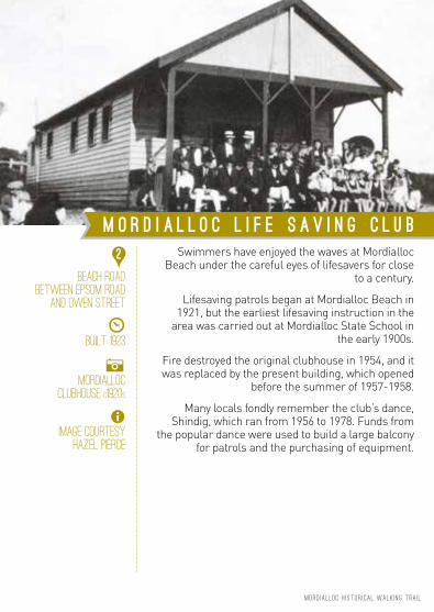
Swimmers have enjoyed the waves at Mordialloc Beach under the careful eyes of lifesavers for close
to a century.
Lifesaving patrols began at Mordialloc Beach in 1921, but the earliest lifesaving instruction in the
area was carried out at Mordialloc State School in the early 1900s.
Fire destroyed the original clubhouse in 1954, and it was replaced by the present building, which opened
before the summer of 1957-1958.
Many locals fondly remember the club’s dance, Shindig, which ran from 1956 to 1978. Funds from
the popular dance were used to build a large balcony for patrols and the purchasing of equipment.
2
Beach Road
Between Epsom Road
and Owen Street
} Built 1923
AMordialloc
clubhouse C1920s
=Image courtesy
Hazel PiercE
MORD I A L L OC H I STOR I CA L WALK I N G TRA I L
M o r d i a l l o c L i f e S a v i n g C l u b

This lovely rotunda is today used for weddings and other celebrations. But in its heyday, it was the home of the Mordialloc District Band, formed in the early 1920s by keen local musicians.
Soon after, an enthusiastic committee realised the band needed somewhere to play. Two carnivals on Creek Reserve (now named the Hazel Pierce Reserve) raised funds for the rotunda’s construction. Open-air jazz dancing, highland dancing, toboggans, slides, a mock police court, decorated boats and a merry-go-round attracted great crowds.
Mordialloc Mayor Cr James Blanche opened the rotunda in November 1925, thanking the enthusiastic ‘self-sacrificing and unselfish’ folk behind its construction. The popular carnivals continued for many years.
By the 1990s, under the direction of the Mordialloc Mentone Lions Club the rotunda, which is supported by eight massive pillars, was painted and revived before being ‘reopened’.
The rotunda sits in the Peter Scullin Reserve, named for the man who was a Mordialloc City Councillor from 1971 to 1975 and Mayor in 1974.
3
Corner Beach Road
and Pier Road
} OPENED 1925
AROTUNDA, ONCE HOME
TO THE MORDIALLOC
DISTRICT BAND
=Image courtesy
Mordialloc and
District Historical
Society
MORD I A L L OC H I STOR I CA L WALK I N G TRA I L
R O T U N D A

Mixed bathing was frowned upon in bygone days, making swimming in Melbourne beaches far from straightforward.
In 1886, Moorabbin Shire Council agreed to build baths at Mordialloc. They were a huge success, with visitors and locals flocking to the new Mordialloc Sea Baths (also known as Rennison’s) from the 1890s until the 1920s.
But by 1925, the condition of the baths had deteriorated, and other funding priorities led to arguments about the future of the baths. A terrible storm in November 1934 appeared to resolve the issue; the sea baths were further damaged and would cost £3000 to repair. The baths were instead demolished.
While no trace of the baths remain today, visitors still enjoy the boulevard along Mordialloc Beach. Backed by a foreshore reserve of native ti-tree, the walkway separates the beach from coastal vegetation with its linear balustrading and lighting columns.
The boulevard, and sea wall from the pier to the former baths, was opened in 1927.
4
CNR Beach Road
and Pier Road
AMordialloc Hot-Sea
Baths, also known
as Rennison’s were
the coast’s most
state-of-the-art
baths
=Image courtesy
Mordialloc and
District Historical
Society
M o r d i a l l o c B e a c h P r o m e n a d e
MORD I A L L OC H I STOR I CA L WALK I N G TRA I L

It is believed the pier began in the 1850s as a small jetty at the mouth of Mordialloc Creek. Early settlers had to rely on ships for heavy materials and supplies as the roads were too poor for transporting such goods.
By 1875, locals campaigning for a longer jetty got their way with an impressive new pier built by the early 1900s.
Locals and visitors would visit the area to fish and promenade on the pier – and even attend open-air church services on Sunday afternoons in the 1920s.
Pounding waves damaged the pier over the years, and in 1983, a proposal was put forward to significantly shorten the structure.
Local boat builder Jack Pompei led a successful campaign against the proposal, with funds to repair the pier raised from councils and the State Government. The pier was again revamped in 2009.
Parks Victoria currently manages the site.
5
Corner Beach Road
and Pier Road
} Built 1850s
AJack Pompei IN 1986
at Mordialloc
Beach Pier with sign
“Save the Mordialloc
Pier Fund”
=Image courtesy
Leader Collection,
City of Kingston.
Photographer:
Philip Rowley
M o r d i a l l o c P I E R
MORD I A L L OC H I STOR I CA L WALK I N G TRA I L

Mordialloc Creek is home to a unique small boating and fishing community, which contribute greatly to
the quaint, friendly atmosphere in Mordialloc.
The creek includes man-made Lambert’s Island, which is a result of ‘straightening’ the waterway to
provide direct access to the Bay.
The grassed area between the creek and the bend in Beach Road was home to an annual summer carnival, which ran a few years from 1906, then
restarted in 1923 to raise funds to build the band rotunda. The carnival became a yearly event
featuring musical acts, dancing, novelty events, performing animals, and fairground rides, sideshows
and amusements.
These delightful murals, painted by Derek Kent in 2004, celebrate both the creek and carnivals of
yesteryear.
6
Beach Road,
Adjacent
Mordialloc Creek
AMordialloc
Creek 1871
=Image courtesy
Mordialloc and
District Historical
Society
MORD I A L L OC H I STOR I CA L WALK I N G TRA I L
M o r d i a l l o c C r e e k a n d M u r a l s

The Hazel Pierce Reserve is also home to one of Mordialloc’s war memorials. The granite monument, with four pillars and a domed cap, was erected to honour locals who served in the Great War. It once featured four drinking taps.
Once known as Creek Reserve, this site now bears the name of prominent local identity Hazel Pierce, who came to the area in the 1940s. Mrs Pierce was twice Mayor of Mordialloc, was president of the Mordialloc Life Saving Club and the Mordialloc Progress Association, and ran a bridal shop in Mordialloc village for decades.
Hazel Pierce Reserve
Corner Beach Road
and MAIN STREET
AWAR MEMORIAL
TO HONOUR LOCAL
SOLDIERS
=IMAGE COURTESY
CITY OF KINGSTON
W a r M e m o r i a l
7
MORD I A L L OC H I STOR I CA L WALK I N G TRA I L

The first hotel on this site was a two-roomed weatherboard building built by William Coleman.
Replaced in 1871 by a double storey bluestone building with a small wing, the hotel
and surrounding gardens rapidly became a popular meeting place.
The building fabric is historically significant, being amongst the oldest in the area. However,
modifications and additions have covered most of the original structure. Virtually none of the original
building can be seen from the Nepean Highway.
The hotel licence was transferred to many notable licensees over the years including local racing and
hunting personality Richard Bloxsidge. Extensive building works ensued over the years and picnic
grounds were expanded to accommodate increasing patronage.
1 Nepean Highway
Adjacent
Pompeis Bridge
} Established 1868
AThe original
BRIDGE HOTEL
=Image courtesy
MORDIALLOC AND
DISTRICT HISTORICAL
SOCIETY
MORD I A L L OC H I STOR I CA L WALK I N G TRA I L
B r i d g e H o t e l
8

This private home is an architecturally significant example of modernist art deco design.
Coolullah House sits on a ridge facing Mordialloc Creek with a beach vista from the rear. The extensive views offered by its prominent location led to the house being used by the RAAF and Navy as a Port Phillip Bay observation post during World War II.
Alterations and renovations have been treated sympathetically, retaining the integrity of the iconic architectural style.
6 Bowman Street
*Private residence
} Built c1932
AUNADORNED SURfaces,
cantilevering
balconies and
awnings are
characteristics
of this delightful
intact dwelling
=Image courtesy
HERITAGE STUDY,
City of Kingston
C o o l U l l a h H o u s e
9
MORD I A L L OC H I STOR I CA L WALK I N G TRA I L

Attenborough Park and Mordialloc Creek Reserve are significant Indigenous sites in the City of
Kingston. Numerous shell middens and scarred trees have been found in the park and adjacent to
the creek, a legacy of the Boon wurrung people.
The park continuously flies the Aboriginal flag, commemorating the Aboriginal reserve that was established here following European settlement. Elders of the Boon wurrung tribe are believed to
have lived out their last days in this area. Mordialloc Creek is on the northern point of Carrum Carrum
Swamp, which forms a natural basin on the peninsula.
Named after early pioneer Thomas Attenborough, who settled in Dingley in the 1850s, Attenborough
Park is also home to a group planting of large Monterey Cypress trees believed to be about
100 years old. The trees are on the City of Kingston Significant Trees Register. The trees are significant
due to the contribution they provide to the surrounding landscape and they are an important
landmark to the local area. The trees are also significant as they are of an outstanding size.
Nepean Highway
Adjacent
Mordialloc Creek
* Significant
indigenous site
AJimmy Dunbar
member of Boon
wurrung people
c1870
=IMAGE Courtesy
Paul Dwyer,
Mordialloc and
District Historical
Society
MORD I A L L OC H I STOR I CA L WALK I N G TRA I L
A t t e n b o r o u g h P a r k
10

The Borough of Mentone and Mordialloc first asked the Victorian Government for a high school in late 1922, quickly followed by a request from the Borough of Carrum. However it was not until February 1924 that the first 131 pupils settled into temporary accommodation in the Mordialloc Mechanics Institute. Edward Brine was the first headmaster, and like all staff, his role was temporary.
The Victorian Government accepted the recommendation from both councils to build a new school on a site at Attenborough Park, next to Mordialloc Creek. In 1927, work on the two-storey building began. The college included chemistry, physics, cookery and art rooms, general classrooms and a library along with a separate block with metal and woodwork training facilities.
On 15 March 1928, the £20,999 building was officially opened. Although planned to accommodate only 400 pupils that year, the school accepted 407 enrolments.
First known as Mordialloc District High School, the school was renamed Mordialloc-Carrum High School in August 1924, then Mordialloc-Chelsea High School in 1929.
Today it is called Mordialloc College.
1 Station Street
} Established 1928
AMordialloc-
Chelsea High C1937
=Image courtesy
David Reynolds,
Kingston Collection,
City of Kingston
M o r d i a l l o c C o l l e g e
11
MORD I A L L OC H I STOR I CA L WALK I N G TRA I L

The Frankston train line was extended from Caulfield to Mordialloc in 1881 and to Frankston in
1882. The train line brought prosperity to Mordialloc and other small coastal towns.
This weatherboard house, built in 1887, is one of only a few houses that still exist in the
area from this time.
It was the first house in the street and was on a large block of the land bounded by Chute, Park and Albert Streets. It appears that there were originally two houses on the block. Number 11 is the second
of these.
Although somewhat altered since the 1880s, the simple, single-storey cottage retains some
architectural significance as a consequence of its early form and detailing.
11 PARK STREET
*Private residence
} 1887
AHenwood Cottage
=City of Kingston
Heritage Study
MORD I A L L OC H I STOR I CA L WALK I N G TRA I L
H e n w o o d C o t t a g e
12

The original Pompei family emigrated from Sicily, settling in Australia in 1912. They established Pompeis of Mordialloc on their own property and in 1921 they began leasing pleasure boats, used for recreation. The family became credited as the most prominent boat builders in the region.
In 1935 the family leased the railway land near Mordialloc Creek, where the boat building business remains today. Over the years the Pompei family is believed to have built the majority of clinker-built boats on the Bay.
The family’s knowledge and passion for the sea meant they were heavily involved in the fishing industry and rescues. Known to many as ‘Mr Mordialloc’, Jack Pompei (1924 – 2009), was a tireless advocate for the creek. Main Street was closed to make way for his funeral procession in 2009.
The land immediately east of Nepean Highway and north of Mordialloc Creek was named ’Pompeis Landing’ in 2007 in recognition of the Pompei boat building business which has been operating for generations and has become a local icon associated with the site. Today, the site is clearly identifiable by the striking public art work ‘Pompeis Boat’.
Nepean Highway,
Adjacent
Mordialloc Creek
, 561 Main Street
AJack Pompei IN 1976
in a muddy
Mordialloc Creek,
=IMAGE Courtesy
Leader Collection,
City of Kingston
P o m p e i s o f M o r d i a l l o c
& P o m p e i s L a n d i n g
13
MORD I A L L OC H I STOR I CA L WALK I N G TRA I L
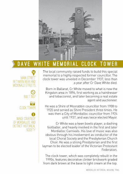
The local community raised funds to build this special memorial to a highly respected former councillor. The clock tower was unveiled in December 1937, less than
a year after Cr Dave White died.
Born in Ballarat, Cr White moved to what is now the Kingston area in 1896, first working as a hairdresser
and tobacconist, and later becoming a real estate agent and auctioneer.
He was a Shire of Moorabbin councillor from 1908 to 1920 and served as Shire President three times. He
was then a City of Mordialloc councillor from 1924 until 1937, and was twice elected Mayor.
Cr White was a keen bowls player, a dashing footballer, and heavily involved in the first and later
Mordialloc Carnivals. His love of music was also obvious through his involvement as conductor of the
local Choral Society and the Presbyterian Church Choir. He was a strong Presbyterian and the first
layman to be elected leader of the Victorian Protestant Federation.
The clock tower, which was completely rebuilt in the 1990s, features decorative clinker brickwork graded
from dark brown at the base to light cream at the top.
Main Street
Between Bear and
McDonald Streets
} Built 1937
AClock Tower
=Image courtesy
of Mordialloc and
District Historical
Society
MORD I A L L OC H I STOR I CA L WALK I N G TRA I L
D a v e W h i t e M e m o r i a l C l o c k T ow e r
14

You might need a break now … and Main Street is the perfect spot to find a great café.
Just as it was a century ago, Main Street is a thriving retail and business centre. The wide street and trees add to its aesthetic appeal and many businesses are housed in heritage buildings.
Before 1880, Main Street consisted mainly of single storey shops with wide verandahs. The extension of the railway line through Mordialloc transformed the settlement into a bustling township with hotels, grocers, bootmakers, dressmakers, and shops that increasingly catered to summer crowds by the 1920s.
The ensuing decades meant more changes, and today Main Street remains a great place to while away a few hours. And if you plan to visit again, the strip is easily accessible by train to Mordialloc station.
MAIN Street,
Between Bear and
McDonald Streets
ABArwon house,
previously known
as the mordialloc
coffee palace and
later grand hotel
1918
=Image courtesy
Mordialloc and
District Historical
Society
M A I N S T R E E T P R E C I N C T
15
MORD I A L L OC H I STOR I CA L WALK I N G TRA I L

Thirty politicians gathered on 19 December 1881 for the official opening of the railway line from Caulfield to
Mordialloc by the Minister of Railways, Thomas Bent.
No station building had been erected – only a single platform. However, contracts were signed a month later for the Mordialloc station building, along with
four other stations on the Frankston line. The station buildings represent the ‘Garden Cottage’ style.
Building Mordialloc station was part of a massive program from the late 1870s to construct railway lines
throughout Victoria.
The railway brought residential and commercial development to the area by providing accessibility and
transport for local produce to the metropolitan market. Importantly, it also brought visitors – who once
only ventured as far as Brighton on a separate but nearby train line.
Between
Main Street and
Albert StreeT
Access via
pedestrian laneway
off Main Street
} Opened 1881
AEntrance Mordialloc
Railway Station
=Image courtesy
Mordialloc and
District Historical
Society
MORD I A L L OC H I STOR I CA L WALK I N G TRA I L
M o r d i a l l o c R a i l w a y S t a t i o n
16

FORMERLY MORDIALLOC COMMON SCHOOL
One acre of Crown Land was originally granted towards the construction of Common School No 846 in 1865 when local residents petitioned the Board of Education to establish a school in the district. A timber building was officially opened on 6 January 1868 for 36 pupils aged from four to 15 years.
The advent of the railway and development of the area led to increased enrolments and the need for a new building. In February 1884, members of the Government visited Mordialloc to open the new school on this site.
The children welcomed the guests singing the national anthem and then listened to various speakers say how fortunate the children were to have the new facilities and the chance of an education.
The brick building with slate roof had a verandah and a detached tower with a spire. While it would initially accommodate 74 children, the plan allowed for extensions. Since then, many additions have been made to the building.
58 Barkly Street
* Strictly no access
to school grounds
and premises
} Opened 1868
AMordialloc State
School 1916
=Image courtesy
Mordialloc and
District Historical
Society
M o r d i a l l o c B e a c h P r i m a r y S c h o o l
17
MORD I A L L OC H I STOR I CA L WALK I N G TRA I L

Prior to 1919 Freemasons living in Mordialloc needed to travel to Moorabbin or Frankston to attend meetings with their brethren. Train journeys were often slow and
tedious so the idea was put forward that a lodge be formed in Mordialloc.
Early meetings were held in the Mechanics’ Hall but members were keen for their own temple. In 1924, the Mordialloc group bought from the Church of England a
block of land in Albert Street, which they later exchanged for another with the Department of Education. It was on
that block they built their temple after negotiating a bank loan to finance the construction.
In October, architects Blackett and Forster presented plans, for the two-storey brick building. Less than a year later, the first meeting of the Mordialloc Masonic Lodge
was held in the completed building.In ensuing years, the building was also used for public events, such as the first courthouse in the municipality
of Mordialloc-Mentone (1926). Renovations were carried out in 1973, but with membership falling by the 1990s,
several lodges combined to build a new temple in Keysborough. In 2008, Mordialloc’s Jack Foley bought
this building to be used as a family home.Kingston City Council bought the Heritage-listed
building for $1.5 million in late 2011, and council officers immediately made the building safe through stabilisation
work and asbestos removal.
81 Albert Street
} Building completed
in 1925
AARCHITECTURAL
DRAWING OF
Mordialloc Masonic
Lodge BY BLACKETT
AND FORSTER
=Image courtesy
JACK FOLEY
Kingston Collection,
City of Kingston
F o r m e r M o r d i a l l o c M a s o n i c L o d g e
18
MORD I A L L OC H I STOR I CA L WALK I N G TRA I L

The Mordialloc railway water tower, built by James Younger in 1910, is the last remaining example of a small group of Edwardian towers of this design.
A substantially intact nineteenth and early twentieth century railway environment including, of course, Mordialloc station, enhances the tower.
The reinforced concrete and brick water tank, an inverted cone shape, can hold 20,000 gallons.
Water towers were once commonly seen at major railway stations and engine houses, to supply water to steam locomotives.
Corner Albert and
Bear Streets
} Built 1910
ASTATe heritage
listed water tower
=IMAGE COURTESY
CITY OF KINGSTON
M o r d i a l l o c R a i l w a y S t a t i o n
W a t e r T o w e r
19
MORD I A L L OC H I STOR I CA L WALK I N G TRA I L

The first Church of England in Mordialloc was built on this site in 1874 and replaced by the present building
St Nicholas’ Anglican Church in the early 1920s.
Designed in 1919 by Louis Williams, who later designed St Andrew’s in Brighton and St John’s
in Camberwell, the Mordialloc church was one of Williams’ first commissions when he came to Victoria
from Tasmania.
Work on the church stalled in 1923 because of a lack of funds and the parish was forced to build temporary
walls along the eastern side of the building - where they stayed for 88 years.
However in late 2011, with a new architect, works were finally completed in harmony in Williams’
original design after the church raised enough money through the sale of its sister church in Edithvale. St Nicholas was consecrated by the Most Reverend Dr
Philip Freier, Archbishop of Melbourne, in 2012.
9 Bear Street
} Built in 1922
ASt Nicholas’
Church of England,
Mordialloc c1930
=Image courtesy
Mordialloc and
District Historical
Society
S t N i c h o l a s ’ A n g l i c a n C h u r c h
20
MORD I A L L OC H I STOR I CA L WALK I N G TRA I L
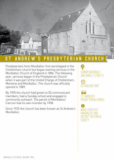
Presbyterians from Mordialloc first worshipped in the Cheltenham church but began evening services in the Mordialloc Church of England in 1886. The following year, services began in the Presbyterian Church when it was part of the United Charge of Cheltenham, Mentone and Mordialloc. The church was officially opened in 1889.
By 1905 the church had grown to 50 communicant members, had a Sunday school and engaged in community outreach. The parish of Mordialloc/Carrum had its own minister by 1908.
Since 1925 the church has been known as St Andrew’s Mordialloc.
Corner McDonald
and Barkly Streets
} Established 1887
ASt Andrew’s
Presbyterian Church
=Image courtesy
Mordialloc and
District Historical
Society
S t A n d r e w ’ s P r e s b y t e r i a n C h u r c h
21
MORD I A L L OC H I STOR I CA L WALK I N G TRA I L

Memorials honour locals who made the ultimate sacrifice in the Great War and World War II.
Dedicated in 1919, the flagstaff and bluestone pedestal was later topped with a large granite cross. The
memorial bears the names of 19 young men who died in the Great War.
After the Second World War, through the initiative of members of the Mordialloc RSL, two 25 Pounder
Short Guns were placed to the north and south of this cenotaph as sentinels. Unfortunately, the service
history of the two Mordialloc guns is unknown.
The salty air of Mordialloc led to corrosion, and extensive restoration took place in the late 2000s, with the guns dismantled, sand blasted, rust protected and
spraypainted.
The guns were replaced in their original positions at the cenotaph in a simple community ceremony
in April 2009.
MAIN Street,
Between Bear and
McDonald Streets
} DEDICATED IN 1919
and 1946
ACENOtaph and guns
to honour local
soldiers
=Image courtesy
Mordialloc and
District Historical
Society
MORD I A L L OC H I STOR I CA L WALK I N G TRA I L
W a r M e m o r i a l
F l a g s t a f f , C e n o t a p h a n d G u n s
22
Originally established as the Mordialloc Hotel, the Mordialloc Sporting Club was built by Alexander Vause Macdonald who emigrated from Scotland to Sydney in 1839. He squatted in Mordialloc with his wife and daughter from 1844 and eventually bought 50 acres from the government.
He built this hotel, originally known as the Mordialloc, in 1853, and operated it until 1859. Macdonald drowned in December 1881 in Mordialloc Creek, the night after the official opening of the Melbourne to Mordialloc railway line.
At one stage, the hotel also operated as a coach office, with four horse coaches running from Melbourne to Frankston daily.
The hotel has been extensively modified and extended since its early days. Most of the later additions have overwritten the building’s early character although some original elements of the building remain visible from the southern side. More than 150 years after Macdonald began his occupancy, the hotel became the Mordialloc Sporting Club.
528 Main Street
} 1853
AHill’s Mordialloc
Hotel c1920
=Image courtesy Kevin
Wilson, Kingston
Collection, City of
Kingston
M o r d i a l l o c S p o r t i n g C l u b
23
MORD I A L L OC H I STOR I CA L WALK I N G TRA I L

The Catholic Church bought Lissadel, originally the private family home of Ellen and Thomas Monahan, in 1949 to use as a presbytery. It is still used for that
purpose today.
The church bought the red brick villa with bay timber windows from the late couple’s niece. Just a few
weeks later, it was announced that Mordialloc was to become a separate parish (from Mentone). Father
James English then took up residence at Lissadel (named after the Monahan’s birthplace in Ireland).
Archbishop Mannix officially opened the presbytery in October 1950.
520 Main Street
*Private residence
} Built 1915
ALissadel – Saint
Brigid’s Parish 1956
=Image courtesy
Saint Brigid’s
Catholic Presbytery
MORD I A L L OC H I STOR I CA L WALK I N G TRA I L
L i s s a d e l
S a i n t B r i g i d ’ s C a t h o l i c P r e s b y t e r y
24
St Brigid’s was built on land left to the church by Mrs Ellen Monahan in the late 1940s. The block remained vacant until 1955, when another parishioner, the late Miss Holt, left £10,000 so work could begin on the construction of the church building.
The impressive stained glass windows at the rear of the church are the work of Victorian artist Alan Somner. One of the windows was donated by members of the 58/59th Australian Battalion Association, as a tribute to those who died during World War 2 in New Guinea and North Solomons. They asked parish priest Father James English – who was their chaplain – to reserve the window for the purpose.
St Brigid’s also features a marble altar from Italy, and candlesticks, altar gates, water fonts and lamps from Dublin. Archbishop Daniel Mannix blessed the church on 28 October 1956.
520 Main Street
} 1956
ASt BRIDGID’S
CATHOLIC CHURCH
WITH IMPRESSIVE
STAINED GLASS
WINDOWS
=IMAGE COURTESY
CITY OF KINGSTON
S t B r i g i d ’ s C a t h o l i c C h u r c h
25
MORD I A L L OC H I STOR I CA L WALK I N G TRA I L

MORD I A L L OC H I STOR I CA L WALK I N G TRA I L
This publication has been compiled and published by the City of Kingston
BIBLIOGRAPHY Alleyn Best & Contributors 2002
50 Years and More - A History of Surf Life Saving Victoria
Frank McGuire 1985 Mordialloc – The Early Days:
A brief History
Frank McGuire 1995 City of Kingston Origins – A Brief Pictorial History
Kingston Historical Website localhistory.kingston.vic.gov.au
Kananook Creek Association Inc home.vicnet.net.au/~kananook/history.htm
Kingston Heritage Study On-Line Search Register
kingston.vic.gov.au/DB/Search.asp
Philip and Margaret Bennett Marvelous Mordialloc Heritage Tour
Tom Sheehy 1970 Mordialloc – Chelsea:
Aspects of History
Veronica Hahn & John Macnaughtan 2003 Epsom at Mordialloc – From Racing
to Training 1889 -1998
Wikipedia en.wikipedia.org/wiki/Mordialloc,_Victoria
CONTRIBUTORS Graham Whitehead
City Historian
Veronica Hahn Leo Gamble Dick Fowler
Mordialloc & District Historic Society
Margaret Hunter Mordialloc Village Committee
Johanna Van Klaveren
Hazel Pierce
Susan Dornom Saint Brigid’s Catholic Presbytery
© 2015 City of Kingston
First edition: 2013 Second revised edition: 2015
For more detailed information visit kingston.vic.gov.au

MORD IALLOC H ISTOR IC WALK ING TRA IL
Standard trail
Distance approximately 3 kilometres Duration approximately 55 minutes
extended TRAIL
Distance approximately 5 kilometres Duration approximately 1 hour 30 minutes
Warning: the extended walk option has some gravel paths and steps which may make it difficult for a person with a physical disability.
MAP LOCATIONS
1 Horse Paddock Car Park2 Mordialloc Life Saving Club3 Rotunda 4 Mordialloc Beach Promenade5 Mordialloc Pier6 Mordialloc Creek and Murals7 War Memorial
Hazel Pierce Reserve8 Bridge Hotel9 Coolallah House10 Attenborough Park11 Mordialloc College12 Henwood Cottage13 Pompeis of Mordialloc and
Pompeis Landing 14 Dave White Memorial Clock
Tower
15 Main Street Precinct 16 Mordialloc Railway Station17 Mordialloc Beach Primary
School 18 Former Mordialloc Masonic
Lodge19 Mordialloc Railway Station
Water Tower20 St Nicholas’ Anglican Church21 St Andrew’s Presbyterian Church22 War Memorial
Flagstaff, Cenotaph and Guns23 Mordialloc Sporting Club24 Lissadel
Saint Brigid’s Catholic Presbytery25 Saint Brigid’s Catholic Church
M O R D I A L L O C
WALKING TRAIL

DRINKING FOUNTAIN
SUGGESTED trail
Standard: Distance approximately 3 kilometres. Duration approximately 55 minutes.
Extended: Distance approximately 5 kilometres. Duration approximately 1hour 30 minutes.
Warning: the extended walk option has some gravel paths and steps which may be difficult to access for a person with a physical disability.
LEGEND
ACKNOWLEDGEMENT
The City of Kingston wishes to acknowledge the elders and people
of the Kulin nation and recognise them as the traditional custodians
of this area.
START
The trail starts at the beachfront adjacent the Horse Paddock car
park on Beach Road. The last point on the trail is a short walk from the starting point, however the trail can
be joined at any point.
PARKING
Parking is available at Horse Paddock car park on Beach Road
between Bay and High Streets. Parking fees apply.
Amenities
Public toilets are located at Peter Scullin Reserve, Attenborough Park
and Mordialloc Railway Station. A drinking fountain is in Hazel
Pierce Reserve.
Refreshments
Food and refreshments can be purchased from Main Street cafes and shops at the halfway point of
the trail.
M O R D I A L L O C
WALKING TRAIL
, MAP LOCATION
} DATE OF ORIGIN
A PHOTO CAPTION
= PHOTO CREDIT
* SPECIAL NOTES
3
2
5
4
6
9
12
15
7
BEACH ROAD
H IGH
ST
EPSO
M RD
OWEN
ST
CENT
REW
AY
PARA
NA S
T
ATTENBOROUGH R
D
BOWMAN ST
BEAR
ST
McDON
ALD
ST
ALBER
T ST
ALBERT ST
BARKLY ST
BARKLY
ST
THOM
AS ST
PARK S
T
GOVENOR RD
BAY S
T
MAIN
STREET
NEPEA
N H IGHW
AY
21
22
14
18
19
20
13
8
10
11
25
24
1
MAP NOT TO SCALE
1 MAP LOCATION
MAP LEGEND
STANDARD WALK
EXTENDED WALK
TOILETS
PARKING
RAIL UNDERPASS
POMPEI BRIDGE UNDERPASS
TRAFFIC LIGHTS
Strictly no access to private property or school premises
17
16
23