Walking in Walking in Bradford on Avon Bradford on Avon · Walking in Bradford on Avon l s Bradford...
8
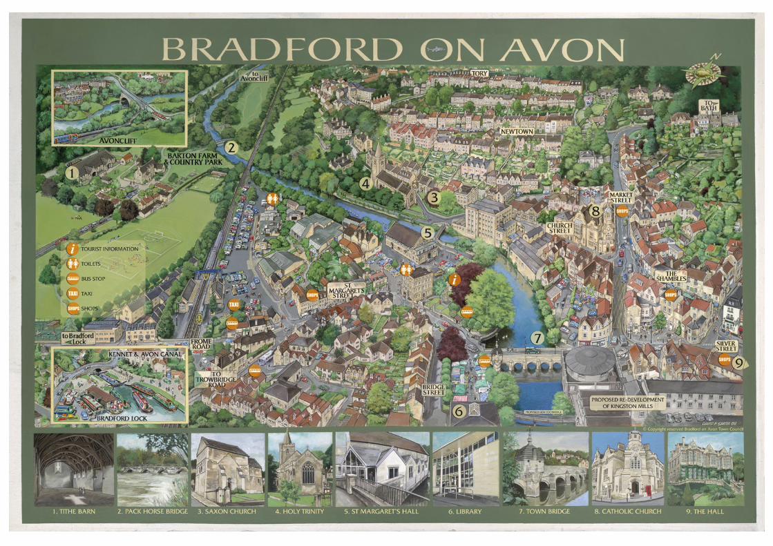
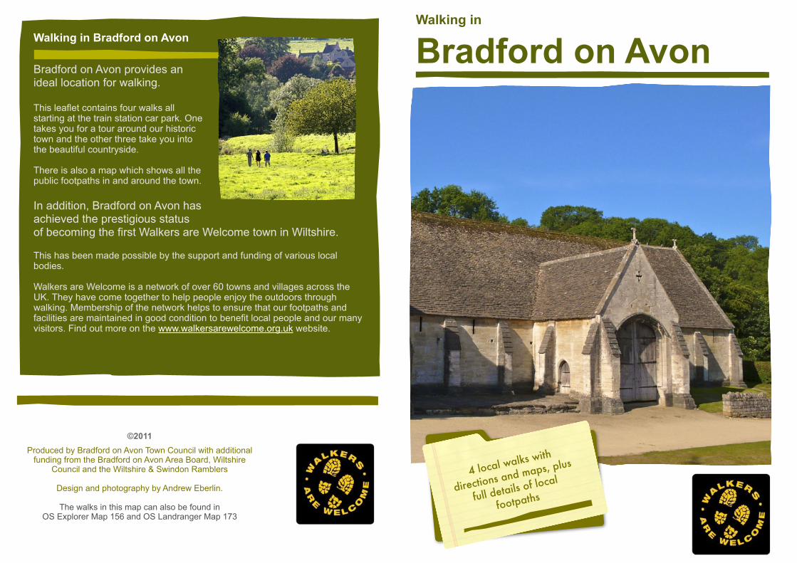
Walking in Bradford on Avon 4 local walks with directions and maps, plus full details of local footpaths Bradford on Avon provides an ideal location for walking. This leaflet contains four walks all starting at the train station car park. One takes you for a tour around our historic town and the other three take you into the beautiful countryside. There is also a map which shows all the public footpaths in and around the town. In addition, Bradford on Avon has achieved the prestigious status of becoming the first Walkers are Welcome town in Wiltshire. This has been made possible by the support and funding of various local bodies. Walkers are Welcome is a network of over 60 towns and villages across the UK. They have come together to help people enjoy the outdoors through walking. Membership of the network helps to ensure that our footpaths and facilities are maintained in good condition to benefit local people and our many visitors. Find out more on the www.walkersarewelcome.org.uk website. Walking in Bradford on Avon ©2011 Produced by Bradford on Avon Town Council with additional funding from the Bradford on Avon Area Board, Wiltshire Council and the Wiltshire & Swindon Ramblers Design and photography by Andrew Eberlin. The walks in this map can also be found in OS Explorer Map 156 and OS Landranger Map 173
Transcript of Walking in Walking in Bradford on Avon Bradford on Avon · Walking in Bradford on Avon l s Bradford...
Walking in
Bradford on Avon
4 local walks with
directions and maps, plus
full details of local
footpaths
Bradford on Avon provides an ideal location for walking.
This leaflet contains four walks all starting at the train station car park. One takes you for a tour around our historic town and the other three take you into the beautiful countryside.
There is also a map which shows all the public footpaths in and around the town.
In addition, Bradford on Avon has achieved the prestigious status of becoming the first Walkers are Welcome town in Wiltshire.
This has been made possible by the support and funding of various local bodies.
Walkers are Welcome is a network of over 60 towns and villages across the UK. They have come together to help people enjoy the outdoors through walking. Membership of the network helps to ensure that our footpaths and facilities are maintained in good condition to benefit local people and our many visitors. Find out more on the www.walkersarewelcome.org.uk website.
Walking in Bradford on Avon
©2011Produced by Bradford on Avon Town Council with additional
funding from the Bradford on Avon Area Board, Wiltshire Council and the Wiltshire & Swindon Ramblers
Design and photography by Andrew Eberlin.
The walks in this map can also be found in OS Explorer Map 156 and OS Landranger Map 173
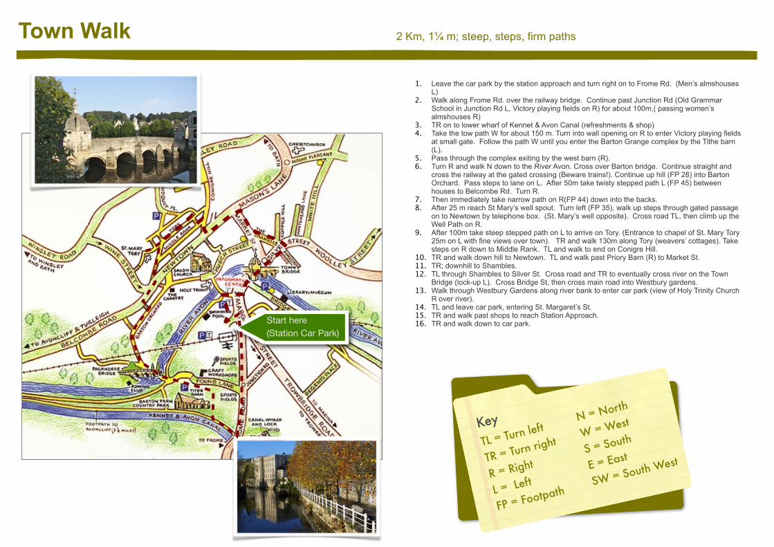
2 Km, 1¼ m; steep, steps, firm paths Town Walk
1. Leave the car park by the station approach and turn right on to Frome Rd. (Men’s almshouses L)
2. Walk along Frome Rd. over the railway bridge. Continue past Junction Rd (Old Grammar School in Junction Rd L, Victory playing fields on R) for about 100m,( passing women’s almshouses R)
3. TR on to lower wharf of Kennet & Avon Canal (refreshments & shop)4. Take the tow path W for about 150 m. Turn into wall opening on R to enter Victory playing fields
at small gate. Follow the path W until you enter the Barton Grange complex by the Tithe barn (L).
5. Pass through the complex exiting by the west barn (R). 6. Turn R and walk N down to the River Avon. Cross over Barton bridge. Continue straight and
cross the railway at the gated crossing (Beware trains!). Continue up hill (FP 28) into Barton Orchard. Pass steps to lane on L. After 50m take twisty stepped path L (FP 45) between houses to Belcombe Rd. Turn R.
7. Then immediately take narrow path on R(FP 44) down into the backs. 8. After 25 m reach St Mary’s well spout. Turn left (FP 35), walk up steps through gated passage
on to Newtown by telephone box. (St. Mary’s well opposite). Cross road TL, then climb up the Well Path on R.
9. After 100m take steep stepped path on L to arrive on Tory. (Entrance to chapel of St. Mary Tory 25m on L with fine views over town). TR and walk 130m along Tory (weavers’ cottages). Take steps on R down to Middle Rank. TL and walk to end on Conigre Hill.
10. TR and walk down hill to Newtown. TL and walk past Priory Barn (R) to Market St. 11. TR; downhill to Shambles.12. TL through Shambles to Silver St. Cross road and TR to eventually cross river on the Town
Bridge (lock-up L). Cross Bridge St, then cross main road into Westbury gardens. 13. Walk through Westbury Gardens along river bank to enter car park (view of Holy Trinity Church
R over river). 14. TL and leave car park, entering St. Margaret’s St. 15. TR and walk past shops to reach Station Approach.16. TR and walk down to car park.Start here
(Station Car Park)
KeyTL = Turn left
TR = Turn right
R = Right
L = Left
FP = Footpath
N = North
W = West
S = South
E = East
SW = South West
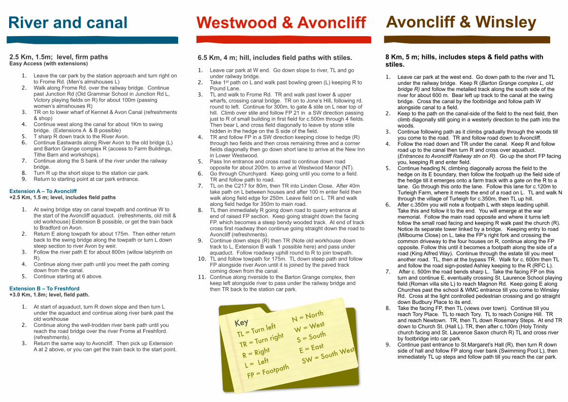
River and canal
2.5 Km, 1.5m; level, firm paths Easy Access (with extensions)
1. Leave the car park by the station approach and turn right on to Frome Rd. (Men’s almshouses L)
2. Walk along Frome Rd. over the railway bridge. Continue past Junction Rd (Old Grammar School in Junction Rd L, Victory playing fields on R) for about 100m (passing women’s almshouses R)
3. TR on to lower wharf of Kennet & Avon Canal (refreshments & shop)
4. Continue west along the canal for about 1Km to swing bridge. (Extensions A & B possible)
5. T sharp R down track to the River Avon. 6. Continue Eastwards along River Avon to the old bridge (L)
and Barton Grange complex R (access to Farm Buildings, Tithe Barn and workshops).
7. Continue along the S bank of the river under the railway bridge.
8. Turn R up the short slope to the station car park. 9. Return to starting point at car park entrance.
Extension A – To Avoncliff +2.5 Km, 1.5 m; level, includes field paths
1. At swing bridge stay on canal towpath and continue W to the start of the Avoncliff aquaduct. (refreshments, old mill & old workhouse) Extension B possible, or get the train back to Bradford on Avon.
2. Return E along towpath for about 175m. Then either return back to the swing bridge along the towpath or turn L down steep section to river Avon by weir.
3. Follow the river path E for about 800m (willow labyrinth on R).
4. Continue along river path until you meet the path coming down from the canal.
5. Continue starting at 6 above.
Extension B – To Freshford+3.0 Km, 1.8m; level, field path.
1. At start of aquaduct, turn R down slope and then turn L under the aquaduct and continue along river bank past the old workhouse
2. Continue along the well-trodden river bank path until you reach the road bridge over the river Frome at Freshford. (refreshments).
3. Return the same way to Avoncliff. Then pick up Extension A at 2 above, or you can get the train back to the start point.
Westwood & Avoncliff Avoncliff & Winsley
6.5 Km, 4 m; hill, includes field paths with stiles.
1. Leave car park at W end. Go down slope to river, TL and go under railway bridge.
2. Take 1st path on L and walk past bowling green (L) keeping R to Pound Lane.
3. TL and walk to Frome Rd. TR and walk past lower & upper wharfs, crossing canal bridge. TR on to Jone’s Hill, following rd. round to left. Continue for 300m, to gate & stile on L near top of hill. Climb over stile and follow FP 21 in a SW direction passing just to R of small building in first field for c.500m through 4 fields. Then bear L and cross field diagonally to leave by stone stile hidden in the hedge on the S side of the field.
4. TR and follow FP in a SW direction keeping close to hedge (R) through two fields and then cross remaining three and a corner fields diagonally then go down short lane to arrive at the New Inn in Lower Westwood.
5. Pass Inn entrance and cross road to continue down road opposite for about 200m. to arrive at Westwood Manor (NT).
6. Go through Churchyard. Keep going until you come to a field. TR and follow path to road.
7. TL on the C217 for 80m, then TR into Linden Close. After 40m take path on L between houses and after 100 m enter field then walk along field edge for 250m. Leave field on L. TR and walk along field hedge for 350m to main road.
8. TL then immediately R going down road to quarry entrance at end of raised FP section. Keep going straight down the facing FP. which becomes a steep bendy wooded track. At end of track cross first roadway then continue going straight down the road to Avoncliff (refreshments).
9. Continue down steps (R) then TR (Note old workhouse down track to L, Extension B walk 1 possible here) and pass under aquaduct. Follow roadway uphill round to R to join towpath.
10. TL and follow towpath for 175m. TL down steep path and follow FP alongside river Avon until it is joined by the paved track coming down from the canal.
11. Continue along riverside to the Barton Grange complex, then keep left alongside river to pass under the railway bridge and then TR back to the station car park.
8 Km, 5 m; hills, includes steps & field paths with stiles.
1. Leave car park at the west end. Go down path to the river and TL under the railway bridge. Keep R (Barton Grange complex L, old bridge R) and follow the metalled track along the south side of the river for about 600 m. Bear left up track to the canal at the swing bridge. Cross the canal by the footbridge and follow path W alongside canal to a field.
2. Keep to the path on the canal-side of the field to the next field, then climb diagonally still going in a westerly direction to the path into the woods.
3. Continue following path as it climbs gradually through the woods till you come to the road. TR and follow road down to Avoncliff.
4. Follow the road down and TR under the canal. Keep R and follow road up to the canal then turn R and cross over aquaduct. (Entrances to Avoncliff Railway stn on R). Go up the short FP facing you, keeping R and enter field.
5. Continue heading N, climbing diagonally across the field to the hedge on its E boundary, then follow the footpath up the field side of the hedge till it emerges onto a farm track with a gate on the R to a lane. Go through this onto the lane. Follow this lane for c.120m to Turleigh Farm, where it meets the end of a road on L. TL and walk N through the village of Turleigh for c.350m, then TL up hill.
6. After c.350m you will note a footpath L with steps leading uphill. Take this and follow it to the end. You will emerge at the war memorial. Follow the main road opposite and where it turns left follow the small road facing and keeping R walk past the church (R). Notice its separate tower linked by a bridge. Keeping entry to road (Milbourne Close) on L, take the FP’s right fork and crossing the common driveway to the four houses on R, continue along the FP opposite. Follow this until it becomes a footpath along the side of a road (King Alfred Way). Continue through the estate till you meet another road. TL, then at the bypass TR. Walk for c. 600m then TL and follow the road sign-posted Ashley keeping to the R (RFC L).
7. After c. 500m the road bends sharp L. Take the facing FP on this turn and continue E, eventually crossing St. Laurence School playing field (Roman villa site L) to reach Magnon Rd. Keep going E along Churches past the school & WMC entrance till you come to Winsley Rd. Cross at the light controlled pedestrian crossing and go straight down Budbury Place to its end.
8. Take the facing FP, then TL (views over town). Continue till you reach Tory Place. TL to reach Tory. TL to reach Conigre Hill. TR and reach Newtown. TR, then TL down Rosemary Steps. At end TR down to Church St. (Hall L). TR, then after c.100m (Holy Trinity church facing and St. Laurence Saxon church R) TL and cross river by footbridge into car park.
9. Continue past entrance to St.Margaret’s Hall (R), then turn R down side of hall and follow FP along river bank (Swimming Pool L), then immediately TL up steps and follow path till you reach the car park.
KeyTL = Turn left
TR = Turn right
R = Right
L = Left
FP = Footpath
N = North
W = West
S = South
E = East
SW = South West
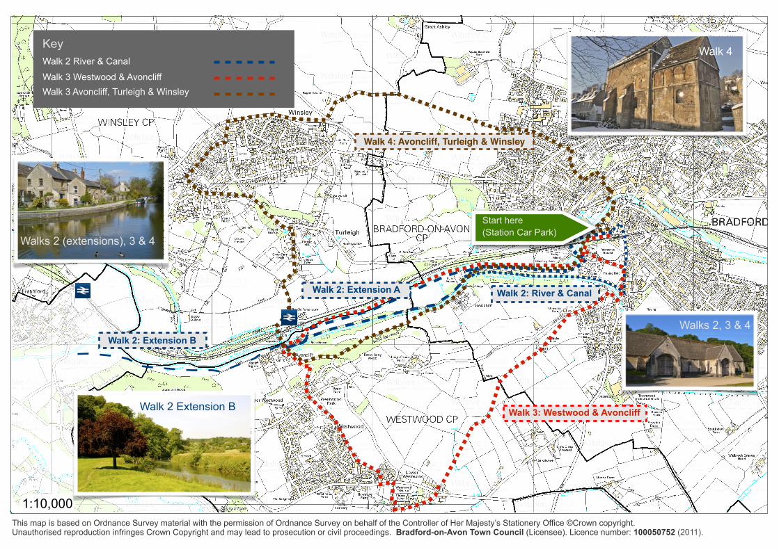
1:10,000This map is based on Ordnance Survey material with the permission of Ordnance Survey on behalf of the Controller of Her Majesty’s Stationery Office ©Crown copyright. Unauthorised reproduction infringes Crown Copyright and may lead to prosecution or civil proceedings. Bradford-on-Avon Town Council (Licensee). Licence number: 100050752 (2011).
Walk 2: River & Canal
Walk 2: Extension B
Walk 2: Extension A
Walk 3: Westwood & Avoncliff
Walk 4: Avoncliff, Turleigh & Winsley
KeyWalk 2 River & Canal
Walk 3 Westwood & AvoncliffWalk 3 Avoncliff, Turleigh & Winsley
Walk 2 Extension B
Walks 2 (extensions), 3 & 4
Walks 2, 3 & 4
Walk 4
Start here (Station Car Park)
1:10,000
1
23
4
56
7
8
8a
9
1011
12
14
15
1515
1616
17
18
19
21
2223
24
25
26
27
27
2727
32
39
85
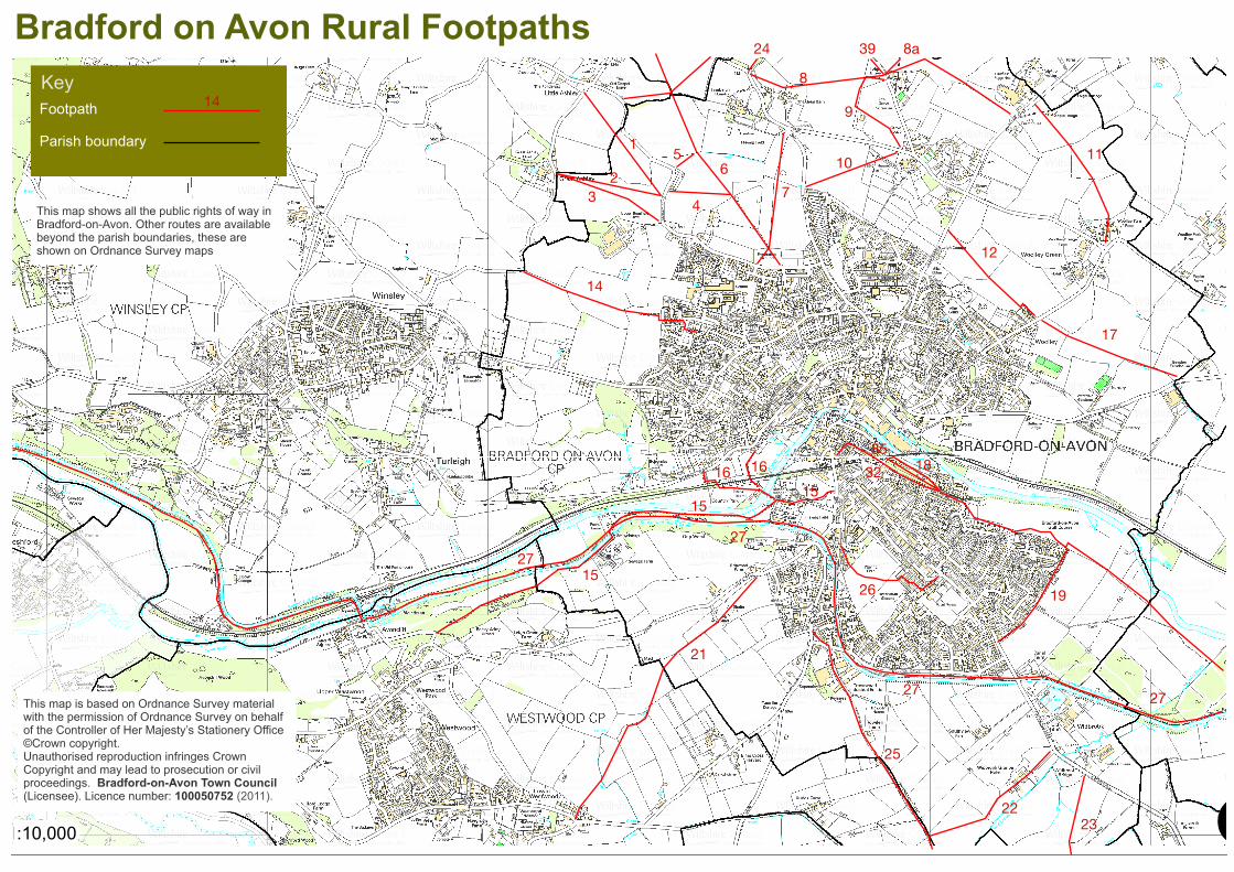
Bradford on Avon Rural FootpathsKey
14Footpath
Parish boundary
This map is based on Ordnance Survey material with the permission of Ordnance Survey on behalf of the Controller of Her Majesty’s Stationery Office ©Crown copyright. Unauthorised reproduction infringes Crown Copyright and may lead to prosecution or civil proceedings. Bradford-on-Avon Town Council (Licensee). Licence number: 100050752 (2011).
This map shows all the public rights of way in Bradford-on-Avon. Other routes are available beyond the parish boundaries, these are shown on Ordnance Survey maps
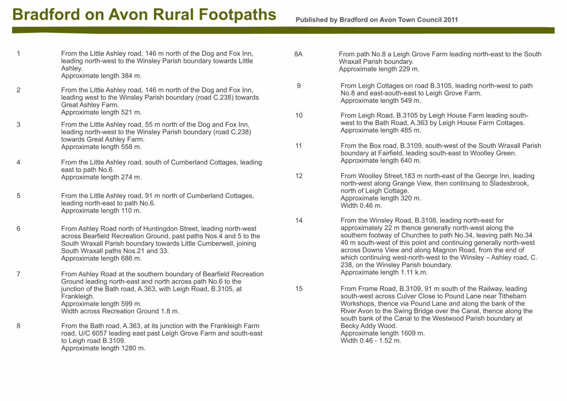
Published by Bradford on Avon Town Council 2011Bradford on Avon Rural Footpaths
1 1 1 From the Little Ashley road, 146 m north of the Dog and Fox Inn, leading north-west to the Winsley Parish boundary towards Little Ashley.Approximate length 384 m.
2 2 2 From the Little Ashley road, 146 m north of the Dog and Fox Inn, leading west to the Winsley Parish boundary (road C.238) towards Great Ashley Farm.Approximate length 521 m.
3 3 3 From the Little Ashley road, 55 m north of the Dog and Fox Inn, leading north-west to the Winsley Parish boundary (road C.238) towards Great Ashley Farm.Approximate length 558 m.
4 4 4 From the Little Ashley road, south of Cumberland Cottages, leading east to path No.6.Approximate length 274 m.
5 5 5 From the Little Ashley road, 91 m north of Cumberland Cottages, leading north-east to path No.6.Approximate length 110 m.
6 6 6 From Ashley Road north of Huntingdon Street, leading north-west across Bearfield Recreation Ground, past paths Nos.4 and 5 to the South Wraxall Parish boundary towards Little Cumberwell, joining South Wraxall paths Nos.21 and 33.Approximate length 686 m.
7 7 7 From Ashley Road at the southern boundary of Bearfield Recreation Ground leading north-east and north across path No.6 to the junction of the Bath road, A.363, with Leigh Road, B.3105, at Frankleigh.Approximate length 599 m.Width across Recreation Ground 1.8 m.
8 8 8 From the Bath road, A.363, at its junction with the Frankleigh Farm road, U/C 6057 leading east past Leigh Grove Farm and south-east to Leigh road B.3109.Approximate length 1280 m.
8A 8A 8A From path No.8 a Leigh Grove Farm leading north-east to the South Wraxall Parish boundary.Approximate length 229 m.
9 9 9 From Leigh Cottages on road B.3105, leading north-west to path No.8 and east-south-east to Leigh Grove Farm.Approximate length 549 m.
101010 From Leigh Road, B.3105 by Leigh House Farm leading south-west to the Bath Road, A.363 by Leigh House Farm Cottages.Approximate length 485 m.
111111 From the Box road, B.3109, south-west of the South Wraxall Parish boundary at Fairfield, leading south-east to Woolley Green.Approximate length 640 m.
121212 From Woolley Street,183 m north-east of the George Inn, leading north-west along Grange View, then continuing to Sladesbrook, north of Leigh Cottage.Approximate length 320 m.Width 0.46 m.
141414 From the Winsley Road, B.3108, leading north-east for approximately 22 m thence generally north-west along the southern footway of Churches to path No.34, leaving path No.34 40 m south-west of this point and continuing generally north-west across Downs View and along Magnon Road, from the end of which continuing west-north-west to the Winsley – Ashley road, C.238, on the Winsley Parish boundary.Approximate length 1.11 k.m.
151515 From Frome Road, B.3109, 91 m south of the Railway, leading south-west across Culver Close to Pound Lane near Tithebarn Workshops, thence via Pound Lane and along the bank of the River Avon to the Swing Bridge over the Canal, thence along the south bank of the Canal to the Westwood Parish boundary at Becky Addy Wood.Approximate length 1609 m.Width 0.46 - 1.52 m.
Published by Bradford on Avon Town Council 2011Bradford on Avon Rural Footpaths
171717 From Holt Road, B.3107, about 450 m east of its junction with Cemetery Lane, at the South Wraxall Parish boundary, leading north-west to Woolley Street, north-east of the entrance to path No.12.Approximate length 640 m.
181818 From the eastern end of Bridge Street at the railway crossing leading generally south-east along the southern side of the River Avon and the northern side of housing estates towards the Holt Parish boundary.Approximate length 1670 m.
191919 From the Trowbridge road, A.363, 183 m north-west of the Beehive Inn, leading north-east to path No.18.Approximate length 254 m.
212121 From a point about 84 m south-west from the junction of Frome Road with Jones Hill, leading south-west across Jones Hill to the Westwood Parish boundary.Approximate length 790 m.
222222 From the Trowbridge road, A.363, at Widbrook Bridge leading south-west past Widbrook Farm to the Westwood Parish boundary at Rowden Lane.Approximate length 457 m.
232323 From the Trowbridge road, A.363, opposite Widbrook House, leading south to the Wingfield Parish boundary towards Trowle Manor Court Farm.Approximate length 183 m.
242424 From the junction of Bath Road, A.363, with Frankleigh Farm Lane, leading north to the South Wraxall Parish boundary towards Great Cumberwell to join South Wraxall path No.22.Approximate length 137 m.Width 0.61 m.
262626 From the Trowbridge Road, A.363, opposite St. Laurence Road leading south-west and along Poulton, thence north-west, south west and then north-west again via estate paths and continuing north-west across the Playing Field to Kennet Gardens and continuing along Kennet Gardens towards the Frome Road, B.3109.Width 2 metres between OS Grid Reference ST 8288 6012 to OS Grid Reference ST 8295 6013Approximate length 581 m.
272727 Canal Towing Path, along the north side of the Canal from the Westwood Parish boundary on the west to the Holt Parish boundary on the east.Approximate length 2816 m.Width 1.22 - 1.52 m.
323232 From St. Margaret's Street, A.363, just south-east of its junction with Frome Road, B.3109, leading north-east and south-east over the Railway Tunnel to path No.18, south of Greenland Mills.Approximate length 640 m.
393939 From the northern end of the Town Street at Leigh Grove, at its junction with path No.9, leading north-west along Grass Lane to its junction with South Wraxall path No.25.Approximate length 153 m.
858585 From path No.32 at grid reference 82816067 leading south-east to join footpath No.18 with two very short spurs to connect with paths 32 and 72 at grid reference 83076055.Approximate length 290 m.Width not less than 1.524 m (5 feet).
161616 From Pound Lane, path No.15 passing under the Arch of Barton Farm House], leading north-west over Barton Bridge where it forks, the northern spur leading north across the railway to Barton Orchard and the main path continuing along the side of the railway, which it later crosses and leads into the Belcombe Road, C230.Approximate length 666 m.
252525 Rowden Lane. From Frome Road, B.3109, south of Elmhurst, leading south-east to the Westwood Parish boundary.Approximate length 457 m.Width 0.61 - 3 m.