W H I T T L E S E A G R E E N W E D G E M A N A G … · the management of the Whittlesea Green ......
20
D r a f t W h i t t l e s e a G r e e n W e d g e M a n a g e m e n t P l a n 2 0 1 1 - 2 0 2 1 W H I T T L E S E A G R E E N W E D G E M A N A G E M E N T P L A N 2 0 1 1 - 2 0 2 1
Transcript of W H I T T L E S E A G R E E N W E D G E M A N A G … · the management of the Whittlesea Green ......

D r a f t W h i t t l e s e a G r e e n W e d g e M a n a g e m e n t P l a n 2 0 1 1 - 2 0 2 1
W H I T T L E S E A G R E E N W E D G E
M A N A G E M E N T P L A N 2 0 1 1 - 2 0 2 1

2D r a f t W h i t t l e s e a G r e e n W e d g e M a n a g e m e n t P l a n 2 0 1 1 - 2 0 2 1
Version 5.0Adopted by City of Whittlesea CouncilJuly 2011
City of WhittleseaStrategic Planning and Design
Additional copies of this document are available from the City of Whittlesea on 9217 2346 or from Council’s website at www.whittlesea.vic.gov.au
The City of Whittlesea would like to thank all the individuals and organisations who took the time to contribute ideas on what they value and where improvements should be made to the management of the Whittlesea Green Wedge.
GraphicsThis page: Sustainable Living Festival Transition Towns 2009

3 D r a f t W h i t t l e s e a G r e e n W e d g e M a n a g e m e n t P l a n 2 0 1 1 - 2 0 2 1
TABLE of CONTENTS EXECUTIVE SUMMARY 5
PART 1 - BACKGROUND 7
Introduction 8Whittlesea Green Wedge 14Community Consultation 17
PART 2 – THEMES 21 Land 22 1. Rural Productivity and Agribusiness 25 2. Rural Land Stewardship 31 3. Landscape Qualities and Rural Design 39 4. Boundaries and Buffers 45 5. Extractive Industry 49 Biodiversity 53 6. Flora, Fauna and Habitat 56 Water 64 7. Waterways and Catchments 65 People 73 8. Communities and Settlements 74 9. Tourism and Recreation 77 10. Heritage and Culture 83 PART 3 – ACTION PLAN 88
Implementing the Management Plan 89
Monitoring and Review 101
APPENDIX Appendix 1: Glossary of Terms 102 Appendix 2: Whittlesea Rate Rebate Scheme 103 Appendix 3: Whittlesea Visual Character Areas 104
REFERENCES 114
4D r a f t W h i t t l e s e a G r e e n W e d g e M a n a g e m e n t P l a n 2 0 1 1 - 2 0 2 1
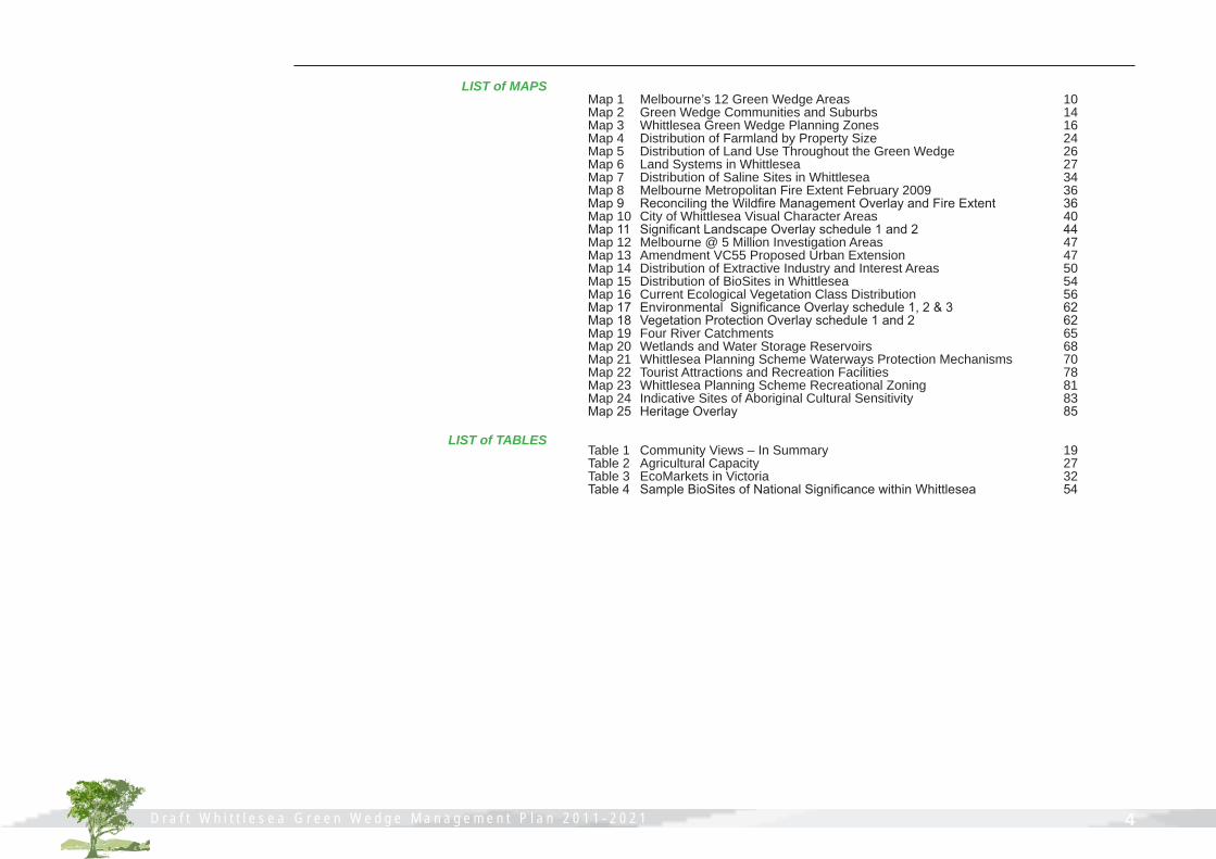
LIST of MAPS
LIST of TABLES
Map 1 Melbourne’s 12 Green Wedge Areas 10Map 2 Green Wedge Communities and Suburbs 14 Map 3 Whittlesea Green Wedge Planning Zones 16Map 4 Distribution of Farmland by Property Size 24Map 5 Distribution of Land Use Throughout the Green Wedge 26Map 6 Land Systems in Whittlesea 27Map 7 Distribution of Saline Sites in Whittlesea 34Map 8 Melbourne Metropolitan Fire Extent February 2009 36Map 9 Reconciling the Wildfire Management Overlay and Fire Extent 36Map 10 City of Whittlesea Visual Character Areas 40Map 11 Significant Landscape Overlay schedule 1 and 2 44Map 12 Melbourne @ 5 Million Investigation Areas 47 Map 13 Amendment VC55 Proposed Urban Extension 47Map 14 Distribution of Extractive Industry and Interest Areas 50Map 15 Distribution of BioSites in Whittlesea 54Map 16 Current Ecological Vegetation Class Distribution 56Map 17 Environmental Significance Overlay schedule 1, 2 & 3 62Map 18 Vegetation Protection Overlay schedule 1 and 2 62Map 19 Four River Catchments 65Map 20 Wetlands and Water Storage Reservoirs 68Map 21 Whittlesea Planning Scheme Waterways Protection Mechanisms 70Map 22 Tourist Attractions and Recreation Facilities 78Map 23 Whittlesea Planning Scheme Recreational Zoning 81Map 24 Indicative Sites of Aboriginal Cultural Sensitivity 83Map 25 Heritage Overlay 85
Table 1 Community Views – In Summary 19 Table 2 Agricultural Capacity 27Table 3 EcoMarkets in Victoria 32 Table 4 Sample BioSites of National Significance within Whittlesea 54
5 D r a f t W h i t t l e s e a G r e e n W e d g e M a n a g e m e n t P l a n 2 0 1 1 - 2 0 2 1
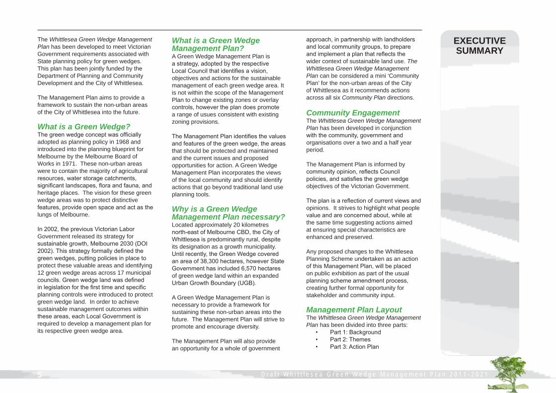
The Whittlesea Green Wedge Management Plan has been developed to meet Victorian Government requirements associated with State planning policy for green wedges. This plan has been jointly funded by the Department of Planning and Community Development and the City of Whittlesea.
The Management Plan aims to provide a framework to sustain the non-urban areas of the City of Whittlesea into the future.
What is a Green Wedge? The green wedge concept was officially adopted as planning policy in 1968 and introduced into the planning blueprint for Melbourne by the Melbourne Board of Works in 1971. These non-urban areas were to contain the majority of agricultural resources, water storage catchments, significant landscapes, flora and fauna, and heritage places. The vision for these green wedge areas was to protect distinctive features, provide open space and act as the lungs of Melbourne.
In 2002, the previous Victorian Labor Government released its strategy for sustainable growth, Melbourne 2030 (DOI 2002). This strategy formally defined the green wedges, putting policies in place to protect these valuable areas and identifying 12 green wedge areas across 17 municipal councils. Green wedge land was defined in legislation for the first time and specific planning controls were introduced to protect green wedge land. In order to achieve sustainable management outcomes within these areas, each Local Government is required to develop a management plan for its respective green wedge area.
What is a Green Wedge Management Plan? A Green Wedge Management Plan is a strategy, adopted by the respective Local Council that identifies a vision, objectives and actions for the sustainable management of each green wedge area. It is not within the scope of the Management Plan to change existing zones or overlay controls, however the plan does promote a range of usues consistent with existing zoning provisions.
The Management Plan identifies the values and features of the green wedge, the areas that should be protected and maintained and the current issues and proposed opportunities for action. A Green Wedge Management Plan incorporates the views of the local community and should identify actions that go beyond traditional land use planning tools.
Why is a Green Wedge Management Plan necessary? Located approximately 20 kilometres north-east of Melbourne CBD, the City of Whittlesea is predominantly rural, despite its designation as a growth municipality. Until recently, the Green Wedge covered an area of 38,300 hectares, however State Government has included 6,570 hectares of green wedge land within an expanded Urban Growth Boundary (UGB).
A Green Wedge Management Plan is necessary to provide a framework for sustaining these non-urban areas into the future. The Management Plan will strive to promote and encourage diversity.
The Management Plan will also provide an opportunity for a whole of government
approach, in partnership with landholdersand local community groups, to prepare and implement a plan that reflects the wider context of sustainable land use. The Whittlesea Green Wedge Management Plan can be considered a mini ‘Community Plan’ for the non-urban areas of the City of Whittlesea as it recommends actions across all six Community Plan directions.
Community EngagementThe Whittlesea Green Wedge Management Plan has been developed in conjunction with the community, government and organisations over a two and a half year period.
The Management Plan is informed by community opinion, reflects Council policies, and satisfies the green wedge objectives of the Victorian Government.
The plan is a reflection of current views and opinions. It strives to highlight what people value and are concerned about, while at the same time suggesting actions aimed at ensuring special characteristics are enhanced and preserved.
Any proposed changes to the Whittlesea Planning Scheme undertaken as an action of this Management Plan, will be placed on public exhibition as part of the usual planning scheme amendment process, creating further formal opportunity for stakeholder and community input.
Management Plan Layout The Whittlesea Green Wedge Management Plan has been divided into three parts: • Part 1: Background • Part 2: Themes • Part 3: Action Plan
EXECUTIVE SUMMARY

6D r a f t W h i t t l e s e a G r e e n W e d g e M a n a g e m e n t P l a n 2 0 1 1 - 2 0 2 1
Implementing the Management PlanThe success of the Whittlesea Green Wedge Management Plan is dependant upon collaboration between Local Government, State Government Departments, Federal Government, agencies, organisations and the community.
This Management Plan identifies eighty two specific actions identified within the ten sub-themes.
The recommended implementation actions have been developed through consultation, current best practice, reference group meetings, and relevant Council strategies, workshops with government departments, agencies, and organisations with an interest in green wedge matters.
These actions are prioritised in the following manner: • Short term priority (1-3 years) • Medium term priority (4-7 years) • Longer term priority (8-10 years)
Short term actions are those most likely to deliver key sustainable outcomes for our green wedge area. They may also be actions that are relatively simple to instigate. Medium term and long term actions are those that are less urgent, or rely on a range of stakeholders and multiple steps before implementation can occur.
These actions represent a range of scales. Fine scale initiatives are specific and achievable at the local level. Local Government scale actions require coordination from one department within Council to drive the delivery of initiatives across Council departments.
State Government scale initiatives require Council to demonstrate leadership in facilitating the big picture green wedge outcomes. This includes those green wedge issues that are common across all green wedges.
Most actions in the communication, networking and expansion of existing program topics may be delivered from existing resources and commitments, including proposed changes to the Whittlesea Planning Scheme. Many of the new initiatives are unfunded. Council will actively investigate opportunities for funding and delivery from a range of sources.
Monitoring and ReviewThis Management Plan has the capacity to guide a whole-of-Government approach to the coordination and implementation of actions across a ten year period. A five year review of the Management Plan will enable the relevancy and the success of the plan in achieving the vision to be reviewed.
Additionally, it is Council’s intention to release a three and seven year report, based on an annual report to Council on the progress of implementation.
Associated DocumentsThe Green Wedge Management Plan comprises of three documents:1. Whittlesea Green Wedge Management Plan 2011-20212. Whittlesea Green Wedge Management Plan 2011-2021: Community Views Final Report3. Whittlesea Green Wedge Management Plan 2011-2021: Summary Fact Sheets
Four Theme ApproachIn order to best reflect the full range of management considerations, Part 2 of this plan has been grouped into the four themes of the Port Phillip and Western Port Regional Catchment Strategy (PPWCMA 2004) – Land, Biodiversity, Water and People. This approach creates a commonality of purpose and presents the findings in a straightforward manner.
Within each of the four themes, a number of sub-themes are included. These ten sub-themes are indicative of the range of local features and values associated with the Whittlesea Green Wedge.
The ten sub-themes of the Management Plan are as follows: LAND1. Rural productivity and agribusiness2. Rural land stewardship3. Landscape qualities and rural design4. Boundaries and buffers5. Extractive industryBIODIVERSITY6. Flora, fauna and habitatWATER7. Waterways and catchmentsPEOPLE8. Communities and settlements9. Tourism and recreation10. Heritage and culture
Each sub-theme includes an objective, describes features and values, specifies community views, and identifies key issues and future directions.
D r a f t W h i t t l e s e a G r e e n W e d g e M a n a g e m e n t P l a n 2 0 1 1 - 2 0 2 1
PART 1 - BACKGROUND

D r a f t W h i t t l e s e a G r e e n W e d g e M a n a g e m e n t P l a n 2 0 1 1 - 2 0 2 1 8D r a f t W h i t t l e s e a G r e e n W e d g e M a n a g e m e n t P l a n 2 0 1 1 - 2 0 2 1
The Whittlesea Green Wedge Management Plan has been developed to satisfy Victorian Government requirements associated with Melbourne 2030 (DOI 2002). This plan has been jointly funded by the Department of Planning and Community Development and the City of Whittlesea.
The Management Plan aims to provide a framework to sustain the non-urban areas of the City of Whittlesea into the future.
While the plan will promote and encourage a balance of land uses, it cannot change existing green wedge zones to urban zones, or recommend changes to the Urban Growth Boundary (UGB).
Management Plan LayoutThe Management Plan has been divided into three parts.
Part 1: BackgroundThe first chapter, ‘Introduction’, presents a state wide context to the plan, inclusive of government legislative frameworks and outlines big picture challenges faced by all green wedge areas.
The second chapter, ’Whittlesea Green Wedge’, provides insight into the range of characteristics within the non-urban areas of the City of Whittlesea.
The next chapter, ‘Community Consultation’ summarises the involvement of the local community in the development of the plan.
Part 2: ThemesThis section is divided into four distinct themes adapted from the Port Phillip and Westernport Catchment Management Authority. Each theme covers specific legislative requirements.
The first of these, ‘Land’, examines five sub-themes: rural productivity and agribusiness, rural land stewardship, landscape qualities and rural design, boundaries and buffers, and extractive industry.
The middle two topics, ‘Biodiversity’ and ‘Water’ cover the sub-themes of flora, fauna and habitat, and waterways and catchments respectively. The final topic, ’People’, examines three sub-themes: communities and settlements, tourism and recreation, and heritage and culture.
Each of these ten sub-themes describes key features and values, identifies community views, relevant Whittlesea Planning Scheme provisions, and specifies incentives and programs.
Part 3: Action PlanThe final two chapters tie aspirational ideas and accountable actions together. ‘Implementing the Management Plan’ brings over eighty actions together in the one place.
These actions have been derived from consultation with the local community, agency and government workshops and discussions with various directorates within the City of Whittlesea.
This section represents the core process towards implementing the Management Plan. Actions have been assigned to a range of stakeholders with the expectation that the City of Whittlesea has a lead role to play.
The last chapter of this Management Plan, ‘Monitoring and Review’, identifies specific targets and sets in place an annual reporting program to the City of Whittlesea (Whittlesea Council). It also proposes a three and seven year mini-review and a five year full review process.
INTRODUCTION
This Management Plan seeks to reflect the wider context of sustainable land use
and development through partnership
with government, landholders and local
community groups

D r a f t W h i t t l e s e a G r e e n W e d g e M a n a g e m e n t P l a n 2 0 1 1 - 2 0 2 1 9 D r a f t W h i t t l e s e a G r e e n W e d g e M a n a g e m e n t P l a n 2 0 1 1 - 2 0 2 1
ContextLocated along the northern urban fringe of Melbourne, the established urban areas of Whittlesea are within 20km of Melbourne’s CBD. However, despite its designation as a growth municipality and recent additions to land within the UGB, the majority of land within the City of Whittlesea remains predominantly rural.
In a land use planning context over 61% of the total area of the municipality is green wedge land (31,730 hectares).
The delineation between urban and non-urban land is defined by the UGB, put in place by the Victorian Government in 2002 to control Melbourne’s growth.
Green wedges are the non-urban areas of metropolitan Melbourne. They safeguard agricultural activities and preserve rural and scenic landscapes, non-renewable resources and natural areas, including water catchments. They also play an important part in Melbourne's open space network and provide opportunities for tourism and recreation.
The green wedges include areas that have high environmental, landscape or cultural heritage values. These areas contain infrastructure that supports urban areas, such as airports and quarries. They also support communities and areas of rural living.
The majority of green wedge designated land is in private ownership. They are dynamic, evolving, active areas that support a diverse range of land uses. The previous Victorian Government’s strategy for sustainable growth, Melbourne 2030, identified 12 green wedge areas across 17
municipal councils (DOI 2002). 1. Werribee South 2. Western Plains South 3. Western Plains North 4. Sunbury 5. Whittlesea 6. Nillumbik 7. Manningham 8. Yarra Valley and Yarra and Dandenong Ranges 9. Southern Ranges 10. Westernport 11. South East 12. Mornington Peninsula
These 12 green wedges surround and define Melbourne's outward growth (refer to Map 1 over the page). Local Councils are required by the Victorian Government to develop individual management plans for each green wedge.
Several of these plans have already been developed and adopted by their respective Council. Another six green wedge management plans are currently being developed with several due for completion shortly.
This Management Plan has been developed in accordance with the Victorian Government’s General Practice Note: Preparing a Green Wedge Management Plan (DSE 2005a).
National FrameworkIn seeking to sustain the rural areas into the future, this Management Plan will draw on Commonwealth legislation. The Environment Protection and Biodiversity Conservation Act 1999 (the EPBC Act) is the Australian Government's central piece of environmental legislation. It provides a legal framework to protect and manage
nationally and internationally important flora, fauna, ecological communities and heritage places. Other national frameworks have been established for relevant aspects such as rural health and aged care, and the delivery of rural and remote education.
State Government FrameworkMelbourne has a significant influence on areas immediately around the metropolitan area and well beyond into the surrounding countryside. In October 2002 the Victorian Government introduced Melbourne 2030, a 30-year plan to manage growth and change across metropolitan Melbourne and the surrounding region.
The strategy formally identified 12 green wedges surrounding metropolitan Melbourne. The Melbourne 2030 vision for green wedges was to encourage their proper management and to protect them for non-urban uses.
Upon its release, the previous State Government made a commitment to review Melbourne 2030 every five years. The first of such reviews was undertaken by an Independent Audit Expert Group, and the results were published in March 2008. The Audit found that the principles and objectives of Melbourne 2030 were sound and becoming increasingly relevant due to the higher than expected population growth.
Due to recent changes in State Government however, the principles and objectives of Melbourne 2030 are under further review. An investigation into a new metropolitan planning strategy for Melbourne is being undertaken. The new strategy will be informed by the most recent information on issues such as population growth and housing capacity.

D r a f t W h i t t l e s e a G r e e n W e d g e M a n a g e m e n t P l a n 2 0 1 1 - 2 0 2 1 10D r a f t W h i t t l e s e a G r e e n W e d g e M a n a g e m e n t P l a n 2 0 1 1 - 2 0 2 1
Werribee South
Western Plains South
Western Plains North
Sunbury
Whittlesea
Nillumbik
Manningham
Yarra Valley and Yarra and
Dandenong Ranges
Southern Ranges
Westernport
South East
Mornington Peninsula
Port Phillip Bay
Western Port
MAP 1 MELBOURNE’S 12 GREEN WEDGE AREAS
GREEN WEDGEEXISTING URBAN AREAURBAN GROWTH BOUNDARY
N0 10 205
KilometersSOURCE: Department of Infrastructure, 2002
* Some of these Green Wedge areas have sine been reduced due to the expansion of the UGB
It will include a comprehensive process of community and stakeholder consultation. It is envisioned that the new policy framework will continue to recognise the importance of maintaining the metropolitan green wedge.
Green wedge land within the City of Whittlesea is of key importance to the liveability, economic strength and environmental health of Melbourne.
Melbourne’s green wedges continue to fulfil a range of roles including:
• agricultural production• conservation and biodiversity areas close to the city• natural ecosystem services such as water catchments• providing and safeguarding sites for infrastructure that supports urban areas (such as airports and sewage treatment plants)• allowing industries such as sand and stone extraction to operate close to major markets• rural and scenic landscapes• enabling the development of networks of open space• providing opportunities for diverse tourism and recreation
Maintaining the values and features inherent in the non-urban areas surrounding the built up areas of Melbourne is crucial to the future prosperity and liveability of the city.
D r a f t W h i t t l e s e a G r e e n W e d g e M a n a g e m e n t P l a n 2 0 1 1 - 2 0 2 1 11 D r a f t W h i t t l e s e a G r e e n W e d g e M a n a g e m e n t P l a n 2 0 1 1 - 2 0 2 1
Protection and management of green wedge areas is becoming increasingly important in the context of climate change, water and fire management, a more sophisticated understanding of sustainability principles and practice, structural adjustment across the farming sector, increasing food transport costs and the rapid population growth of Melbourne. New challenges will also eventuate from the management of interface areas.
The Government has announced it will conduct an audit of Green Wedge land use with input from local councils and communities, to determine whether the current land use schedules in each municipality are the most appropriate for Green Wedge land. In addition to this audit, ongoing measures used to protect green wedges and manage outward growth include:
• Establishment of the Urban Growth Boundary (UGB) to better manage outward expansion and define urban boundaries. State Government is currently preparing a policy approach which may include an ongoing two year review of this boundary.
• Introduction of three new green wedge zones (Green Wedge Zone, Green Wedge A Zone, Farming Zone and Rural Conservation Zone) to tighten the range of uses that are allowed in green wedges so that uses better suited to urban areas are directed to locations nside the UGB and provide further limitations on the subdivision of land to prevent land fragmentation.
• Core Planning Provisions (Clause 57) were introduced into the Victoria Planning Provisions and applied universally to green wedge land to restrict or prohibit certain land uses and to limit the subdivision of land.
• The Planning and Environment (Metropolitan Green Wedge Protection) Act 2003 introduced the requirement for a positive resolution of both Houses of Parliament before the UGB can be changed or for a planning scheme amendment to allow green wedge land to be subdivided into more lots or smaller lots than allowed for in the planning scheme. This legislation also required planning authorities to consult with and be authorised by the Minister for Planning before preparing an amendment applying to green wedge land or to change the UGB.
The Victorian Government is working with Councils and communities to ensure the proper protection, management and planning of these areas through the development of Green Wedge Management Plans (GWMP).
A GWMP is a Council adopted strategy that identifies a vision, objectives and actions to effectively manage the sustainable use and development of each green wedge and to provide a clear land management direction.
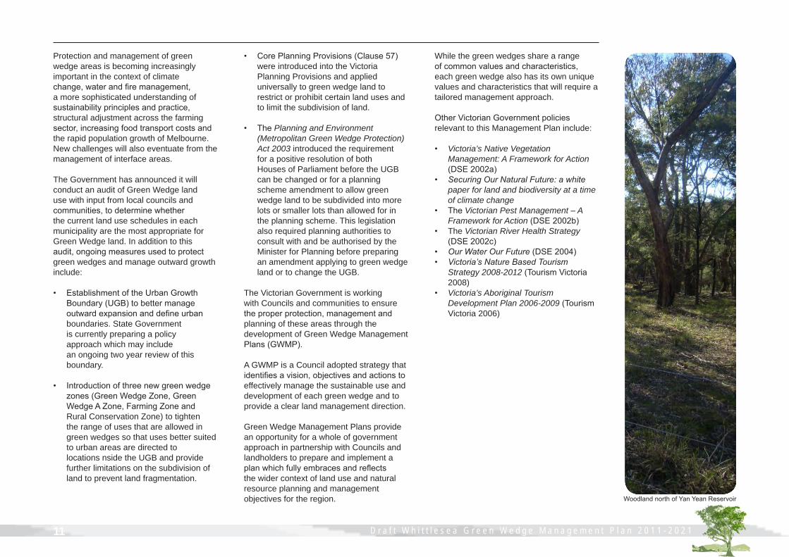
Green Wedge Management Plans provide an opportunity for a whole of government approach in partnership with Councils and landholders to prepare and implement a plan which fully embraces and reflects the wider context of land use and natural resource planning and management objectives for the region. Woodland north of Yan Yean Reservoir
While the green wedges share a range of common values and characteristics, each green wedge also has its own unique values and characteristics that will require a tailored management approach.
Other Victorian Government policies relevant to this Management Plan include:
• Victoria’s Native Vegetation Management: A Framework for Action (DSE 2002a) • SecuringOurNaturalFuture:awhite paper for land and biodiversity at a time of climate change• The Victorian Pest Management – A Framework for Action (DSE 2002b) • The Victorian River Health Strategy (DSE 2002c) • OurWaterOurFuture(DSE 2004) • Victoria’sNatureBasedTourism Strategy 2008-2012 (Tourism Victoria 2008)• Victoria’s Aboriginal Tourism Development Plan 2006-2009 (Tourism Victoria 2006)

D r a f t W h i t t l e s e a G r e e n W e d g e M a n a g e m e n t P l a n 2 0 1 1 - 2 0 2 1 12D r a f t W h i t t l e s e a G r e e n W e d g e M a n a g e m e n t P l a n 2 0 1 1 - 2 0 2 1
Local Government FrameworkIn seeking to sustain the rural areas into the future, this Management Plan will complement other Council policies and strategies aimed at facilitating better rural sustainability.
The Whittlesea Green Wedge Management Plan is aligned to the Whittlesea 2025 - Strategic Community Plan. Development of the Green Wedge Management Plan is identified as a key action toward achieving Future Direction 6: Living Sustainably. The ‘Action Plan’ chapter sets out how each sub-theme aligns with the future directions of the Community Plan.
In 2000, Council released a ‘Draft Rural Review’ document. This comprehensive analysis of the characteristics and conditions of the municipality's rural areas focussed on land use planning mechanisms. This document established a framework for the consideration of land use zoning and development proposals in the rural areas. Awarded recognition by the Planning Institute of Australia, the Rural Review set the benchmark for best practice rural planning principles within the urban-rural interface.
Key achievements of the Rural Review (City of Whittlesea 2000a) include development of the River Red Gum Protection Policy; Amendments to the Whittlesea Planning Scheme to protect areas of significant habitat, waterways and scenic landscapes; rural planning applications to be supported by a Land Management Plan and a visual analysis where required.
Since Council resolved to support and implement the findings of the Rural Review, the Victorian Government released Melbourne 2030 with changes to the planning zones.
Council’s first Local Conservation Strategy was developed in 1992 in response to the range of environmental challenges facing the municipality. The second Local Conservation Strategy (City of Whittlesea 2000b) was released which sought to improve local environmental performance. Council is currently undertaking a review of this document. This Management Plan will help to implement the key directions and goals of the new Environmental Sustainability Strategy.
Key achievements of these conservation strategies include annual Environmental Works Grants for the protection and enhancement of native vegetation on private land; Sustainable Land Management Rate Rebate Scheme to encourage and support good land management practices on large rural properties; annual weed mapping programs and introduction of a pest plant local law; support and education of the community, local Landcare and environment groups through the employment of two Sustainable Land Management Officers, and strengthening economic development in the rural sector.
In October 2009, the Whittlesea Bushfire Recovery Community Reference Committee prepared a bushfire recovery plan for the communities of Whittlesea and surrounding districts in response to the February 2009 fires. Refer to the Community Views Final Report for further details.Typical Plains Grassland

D r a f t W h i t t l e s e a G r e e n W e d g e M a n a g e m e n t P l a n 2 0 1 1 - 2 0 2 1 13 D r a f t W h i t t l e s e a G r e e n W e d g e M a n a g e m e n t P l a n 2 0 1 1 - 2 0 2 1
Big Picture ChallengesThere are numerous challenges faced by green wedge areas in general, and the Whittlesea Green Wedge in particular. These broad scale challenges include:
• Urban-rural interface. Green wedge areas directly abut the expanding outer suburbs of Melbourne. Many of these urban areas are designated growth areas. Conflict at the interface between urban and non-urban uses is not uncommon and land adjoining these areas is often left vacant, or not properly managed in the hope of possible future urban expansion. The government has announced it will increase flexibility in housing choice on the outskirts of our cities and towns – particularly regional cities – by introducing the new Urban Interface Zone (UIZ)”.
• Urban Growth Boundary. As outlined, changes to the Urban Growth Boundary (UGB) have recently been approved in the Victorian Parliament. Ongoing revision of the Management Plan will be required to ensure the relevancy and integrity of the Management Plan.
• Recent fires. The Black Saturday Bushfires of 7 February 2009 left 400,000 hectares of land burnt and 173 lives lost throughout Victoria. In the Whittlesea Green Wedge, almost 200 properties were affected, 8500 hectares were burnt and infrastructure and businesses were affected. The process of rebuilding is still ongoing.
• Lack of local information. Lack of current information regarding the social, environmental and economic features of the green wedge areas often means we do not know what we are losing.
• Agricultural stresses. A widespread downturn in agricultural activities on the urban-rural interface can be attributed to increasing pressures from development speculators, increased farm costs, land and waterway degradation, lack of intergenerational succession and a downturn in agricultural commodities. This has led to a push towards more intensive activities, or the need to increase the size of landholdings. This challenge is at the global scale.
• Green Wedge protection. Consistency, certainty and stamina is needed from local councils, governments and agencies in order to champion and enforce Victorian Government policy to protect green wedges from inappropriate land use and development.
• Climate change. Emerging as one of the major challenges to long term sustainability on a global scale, the unknown affects associated with climate change threaten not only the environmental health, but the social stability and economic viability of the Whittlesea Green Wedge.
Many of these challenges are discussed from a local perspective in the body of this Management Plan.
Secondly, a ten year timeframe for a green wedge management plan can seem idealistic in a changing political landscape. In reality, a management plan sets a much longer framework. This is particularly important when preserving renewable and non-renewable resources, providing conservation areas close to where people live and preserving rural and scenic landscapes.
A collaborative approach from the urban-rural interface Councils is required to deliver outcomes for these big picture challenges. The City of Whittlesea has been actively involved in bringing these issues to the forefront, including most recently a submission to the Inquiry into Sustainable Development of Agribusiness inOuterSuburbanMelbourne, the Biodiversity White Paper (DSE 2009) and the UGB Review as a result of Melbourne @ 5 Million (DPCD 2008a).

D r a f t W h i t t l e s e a G r e e n W e d g e M a n a g e m e n t P l a n 2 0 1 1 - 2 0 2 1 14D r a f t W h i t t l e s e a G r e e n W e d g e M a n a g e m e n t P l a n 2 0 1 1 - 2 0 2 1
The Whittlesea Green Wedge supports a diversity of land uses including farming activities, rural living and small settlements, recreation and tourism opportunities, scenic landscapes, Aboriginal and European heritage places, water storage catchment areas, significant flora and fauna habitats and extraction industries.
The definition of Green Wedge land in the Act is: land that is described in a metropolitan fringe planning scheme as being outside an urban growth boundary. Therefore, the Whittlesea Green Wedge contains the rural communities of Eden Park, Humevale, Kinglake West, Whittlesea, Woodstock (part) and Yan Yean (Map 2).
The population of the City of Whittlesea is currently 132,000 persons, with the population of the Whittlesea Green Wedge around 7,000 persons (ABS 2006).
The Whittlesea Green Wedge comprises 31,730 hectares, which is over 61% of the land area of the municipality. Excluding Whittlesea Township, the land area is around 30,430 hectares and the population is around 3,000 persons.
Yan YeanReservoir
ToorourrongReservoirBEVERIDGE
DONNYBROOK
WOLLERT
WHITTLESEA
HUMEVALE
YAN YEAN
MERNDA
Eden Park
Glenvale
Bruces Creek
Woodstock
Doreen
MAP 2 GREEN WEDGE COMMUNITIES AND SUBURBS
N0 2.5 51.25
KilometersSOURCE: City of Whittlesea, 2010
1 4
6
5
3
2
URBAN GROWTH BOUNDARYEDEN PARKHUMEVALEKINGLAKE WESTWHITTLESEAWOODSTOCK (PART)YAN YEAN
123456
WHITTLESEA GREEN WEDGE
The Whittlesea Green Wedge contains the
non-urban areas of the municipality

D r a f t W h i t t l e s e a G r e e n W e d g e M a n a g e m e n t P l a n 2 0 1 1 - 2 0 2 1 15 D r a f t W h i t t l e s e a G r e e n W e d g e M a n a g e m e n t P l a n 2 0 1 1 - 2 0 2 1
From a metropolitan perspective, the Whittlesea Green Wedge supports the following key features and values:
Local features of value are discussed in greater detail throughout this Management Plan.
Key Features and ValuesThe Whittlesea Green Wedge is characterised by its diversity of landforms, soil types and land uses. Almost half of the Green Wedge is public land used for closed water catchments, national parks and state forests.
The northern elevated section, the Plenty Ranges, is characterised by strongly dissected slopes and valleys which surround cleared rural land and contain the forested areas of Mt. Disappointment and Kinglake National Park. This area has important habitat values and contributes to the Toorourrong and Yan Yean water catchment systems. It also comprises the south-western slopes of the Great Dividing Range.
The Plenty Valley, nested beneath the Plenty Ranges, extends to include the Whittlesea Township and Plenty Gorge. This valley is characterised by a relatively flat central area which has been extensively cleared for agricultural purposes and a steeply defined gorge in the south-eastern portion of the municipality.
Straddling the valley is the Hills area. Though lesser in elevation then the Plenty Ranges, Eden Hills, Whittlesea Hills, Eastern Hills and Quarry Hills provide significant scenic and habitat values.
The western and south-western parts of the municipality, the Western Plains, supports a diverse range of flora and fauna. The plains are low lying, punctuated by rocky outcrops and volcanic cones. The dominant native vegetation types are grasslands and grassy woodlands.
BiodiversityThe Whittlesea Green Wedge is home to a diverse range of native plants and animals, including native grasslands of National and State significance, River Red Gum Grassy Woodland, and forested areas such as Kinglake National Park and Mount Disappointment State Forest. Rural areas provide the majority of habitat for native species, and in some cases, contain the only remaining vegetation community within the region. Healthy natural environments and the ecosystem services they support are important for the prosperity and liveability for which Melbourne is renowned.
AgricultureAreas of productive agricultural land support locally grown produce such as olives, wineries, berry farms and cheese products offered for sale at local markets. Although a part time pursuit for many residents, grazing and equestrian activities are also common. Productive agricultural land is a finite resource and plays an important role in contributing to local food supply and making Melbourne a sustainable city. In the Whittlesea Green Wedge, high value is placed on the quality of the rural landscape, contributing an essential liveability element.
LandscapeSignificant landscapes include the flat agricultural landscape of the Plenty Valley, scattered River Red Gums and majestic Plenty Ranges that provide a scenic backdrop to the city of Melbourne. These rural and natural landscapes provide a sense of place whilst contributing to ecological values, supporting tourism and also being culturally significant. The landscape qualities of the green wedge are a part of Melbourne’s distinctive character and appeal.
WaterThe Whittlesea Green Wedge supports the upper and middle catchment areas of the Plenty River, Darebin Creek and Merri Creek. This area contains several closed water supply catchments that contribute to Melbourne’s water supply, and is home to the Toorourrong and Yan Yean water storage reservoirs. Waterways, wetlands and floodplains within the municipality provide valuable environmental, social and economic benefits for residents and visitors alike.
Communities and SettlementsThe Green Wedge is highly valued for its liveability with many small rural settlements and areas of rural living. The township of Whittlesea is the most significant, containing around half of the rural population. Many residents are attracted to the green wedge by the rural lifestyle and sense of community.
Tourism and RecreationThe Whittlesea Green Wedge supports a wide range of recreational pursuits, natural attractions and events. Key attractions range from the Country Music Festival to the Whittlesea Agricultural Show. Other attractions include farmers markets, golf courses, local farm gate products, bushwalking, camping and horse riding trails. These activities deliver important economic, social and environmental benefits to local communities and broader Melbourne.
HeritageBefore European settlement, the Aboriginal people of the Wurundjeri wilam clan inhabited the area. There are many sites of cultural significance throughout the green wedge associated with Aboriginal culture, such as scarred trees, along waterways and stony rises. Remnants of early European settlement occur on rural living lots and broadacre farms, often delineated by dry stone walls, outbuildings and historic hedgerows.These sites hold special meaning for all Melburnians and need to be sustained for future generations.
Extractive IndustrySeveral extractive industry operations which were previously located within the Whittlesea Green Wedge area have been included within the new UGB, leaving only two of the current Work Authorities partly located within the Green Wedge. Extractive industries play a fundamental role in supporting Melbourne’s future development and prosperity.
D r a f t W h i t t l e s e a G r e e n W e d g e M a n a g e m e n t P l a n 2 0 1 1 - 2 0 2 1 16D r a f t W h i t t l e s e a G r e e n W e d g e M a n a g e m e n t P l a n 2 0 1 1 - 2 0 2 1
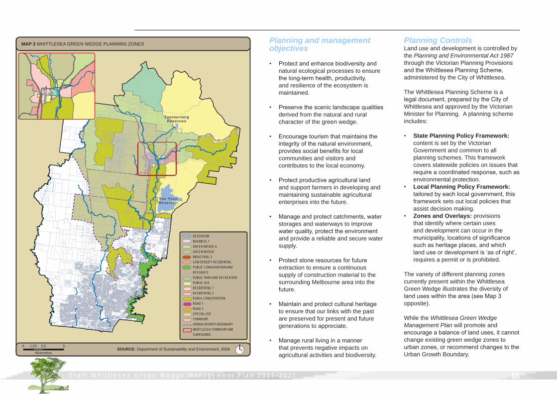
Planning and management objectives
• Protect and enhance biodiversity and natural ecological processes to ensure the long-term health, productivity, and resilience of the ecosystem is maintained.
• Preserve the scenic landscape qualities derived from the natural and rural character of the green wedge.
• Encourage tourism that maintains the integrity of the natural environment, provides social benefits for local communities and visitors and contributes to the local economy.
• Protect productive agricultural land and support farmers in developing and maintaining sustainable agricultural enterprises into the future.
• Manage and protect catchments, water storages and waterways to improve water quality, protect the environment and provide a reliable and secure water supply.
• Protect stone resources for future extraction to ensure a continuous supply of construction material to the surrounding Melbourne area into the future.
• Maintain and protect cultural heritage to ensure that our links with the past are preserved for present and future generations to appreciate.
• Manage rural living in a manner that prevents negative impacts on agricultural activities and biodiversity.
Yan YeanReservoir
ToorourrongReservoir
RESERVOIRBUSINESS 1GREEN WEDGE AGREEN WEDGEINDUSTRIAL 3LOW DENSITY RESIDENTIALPUBLIC CONSERVATION AND RESOURCEPUBLIC PARK AND RECREATIONPUBLIC USE RESIDENTIAL 1RESIDENTIAL 2RURAL CONSERVATIONROAD 1ROAD 2SPECIAL USETOWNSHIPURBAN GROWTH BOUNDARYWHITTLESEA TOWNSHIP AND SURROUNDS
MAP 3 WHITTLESEA GREEN WEDGE PLANNING ZONES
N0 2.5 51.25
KilometersSOURCE: Department of Sustainability and Environment, 2009
Planning ControlsLand use and development is controlled by the Planning and Environmental Act 1987 through the Victorian Planning Provisions and the Whittlesea Planning Scheme, administered by the City of Whittlesea.
The Whittlesea Planning Scheme is a legal document, prepared by the City of Whittlesea and approved by the Victorian Minister for Planning. A planning scheme includes:
• State Planning Policy Framework: content is set by the Victorian Government and common to all planning schemes. This framework covers statewide policies on issues that require a coordinated response, such as environmental protection.
• Local Planning Policy Framework: tailored by each local government, this framework sets out local policies that assist decision making.
• Zones and Overlays: provisions that identify where certain uses and development can occur in the municipality, locations of significance such as heritage places, and which land use or development is ‘as of right’, requires a permit or is prohibited.
The variety of different planning zones currently present within the Whittlesea Green Wedge illustrates the diversity of land uses within the area (see Map 3 opposite).
While the Whittlesea Green Wedge Management Plan will promote and encourage a balance of land uses, it cannot change existing green wedge zones to urban zones, or recommend changes to the Urban Growth Boundary.

D r a f t W h i t t l e s e a G r e e n W e d g e M a n a g e m e n t P l a n 2 0 1 1 - 2 0 2 1 17 D r a f t W h i t t l e s e a G r e e n W e d g e M a n a g e m e n t P l a n 2 0 1 1 - 2 0 2 1
COMMUNITY CONSULTATION
Engagement with the community enhances
the quality of this plan adding a local angle and
relevancy to wide ranging issues
The City of Whittlesea consulted widely with the community, agencies and organisations during 2008 and 2009 for their ideas and aspirations for the Whittlesea Green Wedge.
Consultations involved community forums and focus group discussions, workshops and one-on-one interviews based around two topical papers.
Project information was posted prominently in Council’s Civic Centre foyer and the community was invited to have their say on rural issues through local media articles and via Council’s website. A mailing list was established with a dedicated project email address to facilitate direct correspondence.
Residents, business owners, community groups, local and state government representatives, organisations, a local Councillor and interested individuals all took the opportunity to provide their thoughts and proposals.
This Management Plan aims to capture the breadth of their ideas, whilst providing an indication of community focus.
This section is based on responses received to two documents (referred to as topical papers): 1. Green Wedge Discussion Paper2. Green Wedge Community Views Paper
The VisionWhittlesea’s vision for its green wedge areas is based on consultation and founded on sustainability, connections, opportunity and diversity.
Recognising the complexity of these components, our vision is as follows:
Green Wedge Vision
The Whittlesea Green Wedge will be an environment where the connection between its people and the land is respected and valued, and where innovative and sustainable land management practices are directed towards the enhancement and protection of productive and natural resources.
Green Wedge GoalsFour goals have been modified and adapted from the Port Phillip and Western Port Regional Catchment Strategy (PPWCMA 2004).
These goals seek to achieve the vision and are derived from consultation with the local community. They are as follows:
GREEN WEDGE GOALSLand: Healthy land used sustainably, productively and innovativelyBiodiversity: Healthy and enduring ecosystems with a variety of habitats and native speciesWater: Sustainable water use and healthy waterways, wetlands and groundwaterPeople: A connected community that respects, values and celebrates its past, present and future.
The first topical paperIt was important to Council to build a clear understanding of the values and purpose of the Whittlesea Green Wedge, before recommending priorities, tools and techniques for sustainable management.
The first topical paper titled Whittlesea Green Wedge Discussion Paper was released in three formats in order to capture feedback from a variety of sources.
The community readily provided opinions on the most important features of the Whittlesea Green Wedge. It was even suggested these top features could be called ‘jewels’ - an effective analogy to identify the most important aspects for consideration in planning for the future of the Whittlesea Green Wedge.
The top Green Wedge features are clear:
Top Green Wedge Features1. Rural and natural landscapes: Rural vistas against forested mountain backdrops, green spaces, sparse buildings and open spaces2. Vegetation communities: Habitat and biodiversity, in particular the vulnerable floristic communities of the River Red Gum Grassy Woodland and Plains Grassland3. Native wildlife: Conservation and active management that provides opportunity to view and experience wildlife in proximity to settlements

D r a f t W h i t t l e s e a G r e e n W e d g e M a n a g e m e n t P l a n 2 0 1 1 - 2 0 2 1 18D r a f t W h i t t l e s e a G r e e n W e d g e M a n a g e m e n t P l a n 2 0 1 1 - 2 0 2 1
A consistent theme emerging from the consultation is that rural landscapes and significant habitats are the most valued features, receiving two to three times the number of responses in comparison to other features. The fact that many respondents derive at least part of their livelihood from the green wedge and actively experience nature has positively influenced what aspects people value.
A range of views were also expressed to reflect what is valuable to the community about the Whittlesea Green Wedge. These responses go beyond the typical triple bottom line of economic, social and environmental values to hone in on specific aspects that give the Green Wedge value.
Top Green Wedge Values1. Rural vistas: Visually open, green spaces, atmosphere, peace and quiet, ‘vista of Melbourne’ providing a visual break from residential development2. Connection to the land: Good land stewardship, productivity of rural activities, intergenerational knowledge and experience3. Connection to each other: Social links between residents and government leads to wellbeing and harmony4. Biodiversity: Upper reaches of several water catchments, ‘lungs of Melbourne’ and conservation of a range of habitats5. History: Links to past and present places of significance
Value is attached to the interactions between these aspects. In particular, the clustering of human values reflects a sense of place that strongly contributes to community wellbeing.
The landscape is recognised as a valuable resource that contributes to the liveability of the municipality. Yet the main values are not all anthropocentric. Environmental features and natural assets are considered to have their own intrinsic value. Access to these natural areas is also considered important to the community.
Attendees of the two community forums also took the opportunity to provide their thoughts on a range of issues, opportunities and actions for consideration in the Whittlesea Green Wedge. Over 200 ideas were expressed, many outside the reach of land use planning.
The second topical paperThe second paper titled Whittlesea Green Wedge Community Views Paper was released in order to ensure Council had captured the range of community and organisation aspirations and to determine priorities.
Community ideas on the top features and values of the Whittlesea Green Wedge as expressed in response to the first paper were listed and submissions were sought to validate or correct these priorities.
The two strongest values remained rural scenic landscapes with associated ambience and the biodiversity of the Green Wedge. The sheer variety of vegetation communities - from grasslands, to grassy woodlands and wet forests - was particularly valued.
Interestingly, the top features still included scenic landscapes and significant habitats, yet this time the community included water supply catchments as a significant feature of the Whittlesea Green Wedge.
Views were also sought on a vision for the Whittlesea Green Wedge. Three statements were offered based on responses to key messages expressed by respondents to the first topical paper. Responses helped define the vision statement.
Community views summaryAlthough our green wedge communities are experiencing pressures from a variety of sources, they exhibit a real connection, commitment and passion for the land and each other. The Community Views Final Report is to be read in conjunction with this Management Plan.
Despite the range of opinions expressed during the consultation periods, the rural landscape with its mountain backdrops, green open spaces and few rural buildings was identified as the top feature requiring consideration in planning for the future of our Green Wedge areas.
The value attributed to interactions between people and the land reflects a strong sense of place that leads to community and individual wellbeing.
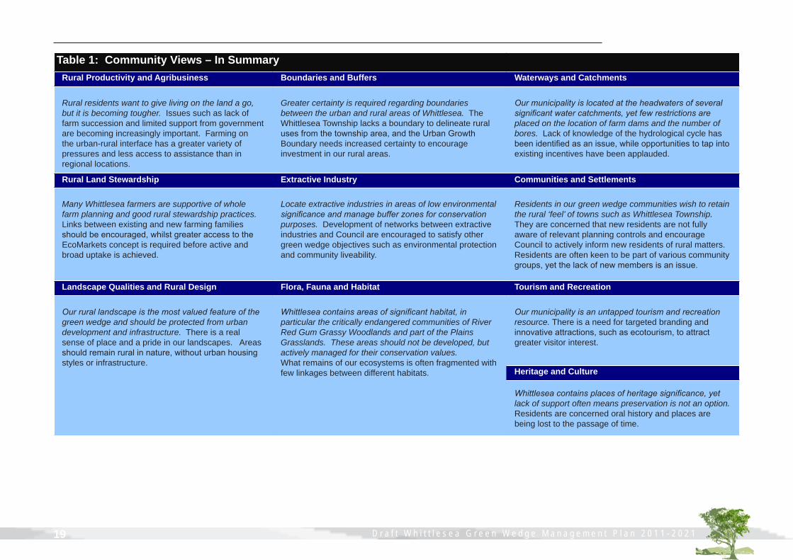
Table 1 on following page attempts to present a summary of common threads across the ten sub-themes.
D r a f t W h i t t l e s e a G r e e n W e d g e M a n a g e m e n t P l a n 2 0 1 1 - 2 0 2 1 19 D r a f t W h i t t l e s e a G r e e n W e d g e M a n a g e m e n t P l a n 2 0 1 1 - 2 0 2 1
Table 1: Community Views – In SummaryRural Productivity and Agribusiness Boundaries and Buffers Waterways and Catchments
Rural residents want to give living on the land a go, but it is becoming tougher. Issues such as lack of farm succession and limited support from government are becoming increasingly important. Farming on the urban-rural interface has a greater variety of pressures and less access to assistance than in regional locations.
Greater certainty is required regarding boundaries between the urban and rural areas of Whittlesea. The Whittlesea Township lacks a boundary to delineate rural uses from the township area, and the Urban Growth Boundary needs increased certainty to encourage investment in our rural areas.
Ourmunicipalityislocatedattheheadwatersofseveralsignificantwatercatchments,yetfewrestrictionsareplaced on the location of farm dams and the number of bores. Lack of knowledge of the hydrological cycle has been identified as an issue, while opportunities to tap into existing incentives have been applauded.
Rural Land Stewardship Extractive Industry Communities and Settlements
Many Whittlesea farmers are supportive of whole farm planning and good rural stewardship practices. Links between existing and new farming families should be encouraged, whilst greater access to the EcoMarkets concept is required before active and broad uptake is achieved.
Locate extractive industries in areas of low environmental significanceandmanagebufferzonesforconservationpurposes. Development of networks between extractive industries and Council are encouraged to satisfy other green wedge objectives such as environmental protection and community liveability.
Residents in our green wedge communities wish to retain the rural ‘feel’ of towns such as Whittlesea Township. They are concerned that new residents are not fully aware of relevant planning controls and encourage Council to actively inform new residents of rural matters. Residents are often keen to be part of various community groups, yet the lack of new members is an issue.
Landscape Qualities and Rural Design Flora, Fauna and Habitat Tourism and Recreation
Ourrurallandscapeisthemostvaluedfeatureofthegreen wedge and should be protected from urban development and infrastructure. There is a real sense of place and a pride in our landscapes. Areas should remain rural in nature, without urban housing styles or infrastructure.
Whittleseacontainsareasofsignificanthabitat,inparticular the critically endangered communities of River Red Gum Grassy Woodlands and part of the Plains Grasslands. These areas should not be developed, but actively managed for their conservation values. What remains of our ecosystems is often fragmented with few linkages between different habitats.
Ourmunicipalityisanuntappedtourismandrecreationresource. There is a need for targeted branding and innovative attractions, such as ecotourism, to attract greater visitor interest.
Whittleseacontainsplacesofheritagesignificance,yetlack of support often means preservation is not an option. Residents are concerned oral history and places are being lost to the passage of time.
Heritage and Culture

Farmland in Mernda