VIZAG- NMT CITY SPECIFIC PLAN - Sustainable Urban ... Presentations/City...and Gajuwaka Source:...
60
VIZAG- NMT CITY SPECIFIC PLAN CONSULTANCY SERVICES FOR DEVELOPING GUIDANCE DOCUMENTS FOR TRANSIT ORIENTED DEVELOPMENT, NON- MOTORISED TRANSPORTATION PLAN AND PUBLIC BIKE SHARING SCHEME
Transcript of VIZAG- NMT CITY SPECIFIC PLAN - Sustainable Urban ... Presentations/City...and Gajuwaka Source:...

VIZAG- NMT CITY SPECIFIC PLANCONSULTANCY SERVICES FOR DEVELOPING GUIDANCE
DOCUMENTS FOR TRANSIT ORIENTED DEVELOPMENT, NON-
MOTORISED TRANSPORTATION PLAN AND PUBLIC BIKE SHARING
SCHEME

Project Overview
The Sustainable Urban Transport Project (SUTP) is a capacity building programme that is jointly funded by MoUD, GEF, World Bank and UNDP
Project Objectives
Enhance capacity in implementing plans for Non-motorized transportation, public bike sharing, transit-oriented development
Develop guidance documents
Prepare city-specific plans

Proposed Demonstration City (NMT) –
Why Vishakhapatnam?
Tier II City
Regionally Development Focused along Transit Corridors
High Pedestrian Modal Share which is steadily decreasing.
Important Regional Linkage connecting Chennai and Kolkata
Increasing Pollution, Congestion and Accidents observed
Opportunity: to contribute/learn from the ongoing update of the Development Plan,
The investment in the Metro Lines; and now the Smart City Challenge
Challenge: to provide walking and cycling infrastructure in the highly variable terrain
of Vizag; to provide universal accessibility to elderly, the disabled; to implement a
public bike sharing scheme in Vizag
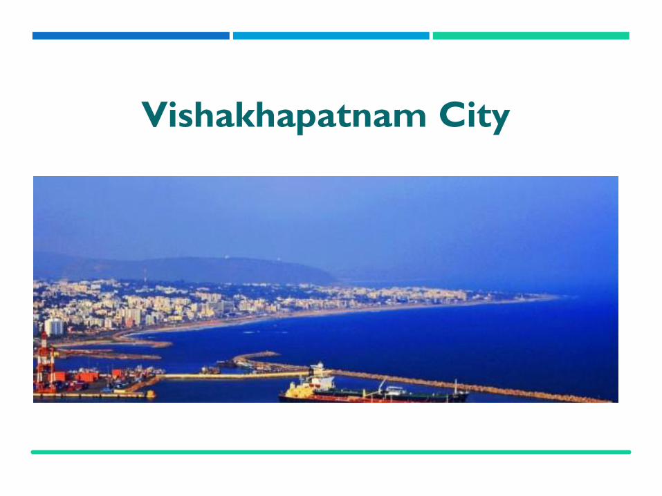
Vishakhapatnam City

Visakhapatnam or Vizag is a portcity on the southeast coast of Bay ofBengal and the second largest urbanagglomeration in Andhra Pradesh.It has a population of about 1.73million as per Census, 2011. Thecity is known for heavy industriesand steel plant.
It is the largest seaport of India andoldest shipyard. It has the onlynatural harbour of India andheadquarters of the Eastern NavalCommand of the Indian Navy.
Vishakhapatnam –The Port City
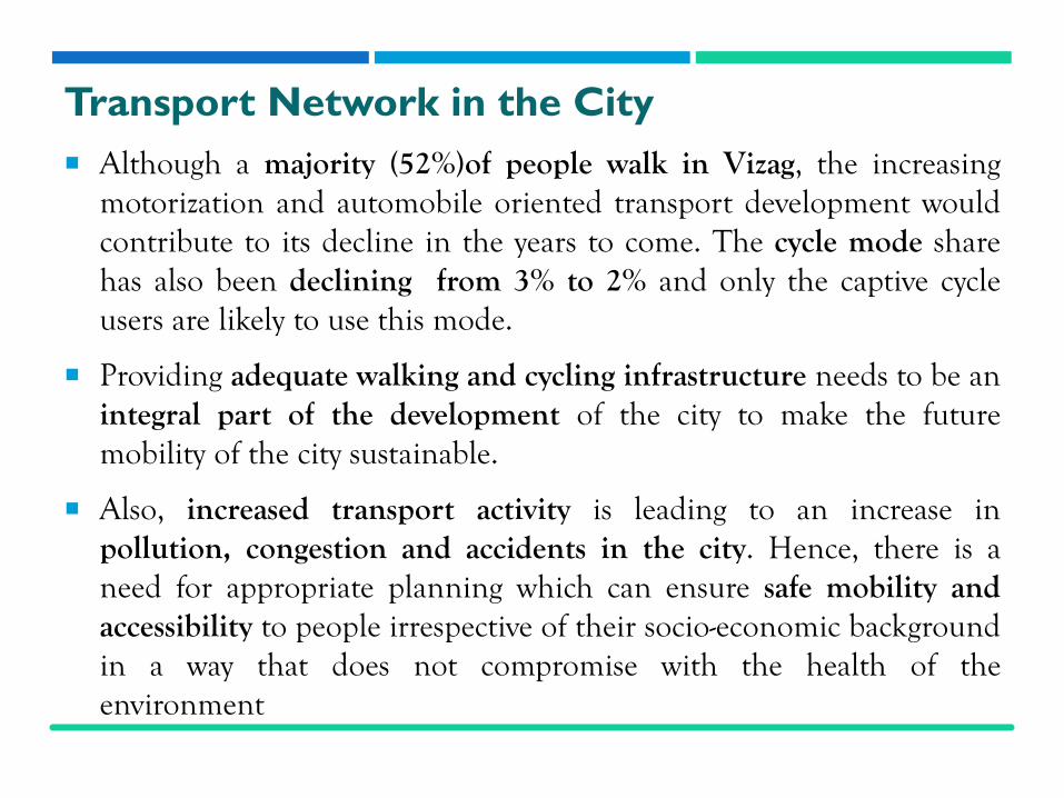
Transport Network in the City
Although a majority (52%)of people walk in Vizag, the increasingmotorization and automobile oriented transport development wouldcontribute to its decline in the years to come. The cycle mode sharehas also been declining from 3% to 2% and only the captive cycleusers are likely to use this mode.
Providing adequate walking and cycling infrastructure needs to be anintegral part of the development of the city to make the futuremobility of the city sustainable.
Also, increased transport activity is leading to an increase inpollution, congestion and accidents in the city. Hence, there is aneed for appropriate planning which can ensure safe mobility andaccessibility to people irrespective of their socio-economic backgroundin a way that does not compromise with the health of theenvironment

Assessment

Regional Setting

Existing City Structure
of VizagLand use pattern as per the Master Plan, Vizag, Andhra
Pradesh
Land Use Planning
ComponentArea (sq. km) Total Population (in lakh)
2001 2006 2001 2006 2011 2021
Municipal Corporation
111 540 9.69 14.5 16.61 20.99
VUDA 1701 1701 22.02 26.21 30.58 34.99
Existing Land Use Patterns
of Vizag
Land use typeBuilt uparea (in sq.km)
% Area
Occupie
d
Industrial 95 57%
Residential 38 23%
Commercial 2 1%
Public Spaces 1 1%
Roads 17 10%
Railways+ Airport+ Bus Terminals
11 6%
Other 2 1%
Total 166 100%

GVMC Population = 1.73 million
Greater VishakapatnamMunicipal Corporation =
534 sqkm
Regional Connectivity through
VizagPopulation Density of
Vizag

City Road Network Hierarchy

Unusable Footpaths due to drain covers
Width of Footpath
(in m)Length (km)
1.5 67
2.0 6
3.0 4
Total 77
Length and width of available
footpaths in Visakhapatnam
Quality of Footpath
Infrastructure
Quality of footpathProportion of
footpaths
No encroachments 30%
Discontinuous 50%
Mostly un-usable 20%
Total 100%
Inadequate street infrastructure along the NH-5
Existing Pedestrian Facilities

Mode Total
Walk 52%
Car 2%
2-Wheeler 15%
Bus 18%
Auto Rickshaw 9%
Cycle 3%
Others 1%
Total 100%
Mode Shares in Visakhapatnam, 2013
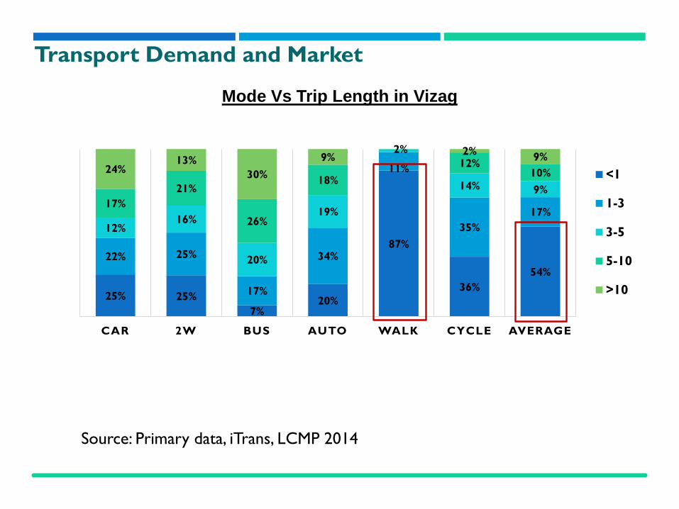
Transport Demand and Market

Transport Demand and Market
8% 10%
28%23%
31%38% 37%
28%15%
37%
39%42%
45%
42%37%
50%
24%
33%
21% 25%
17% 13%19%
18%
40%
17%10% 8%
5% 6%4%
13%2% 1% 2%
1% 1%7%
0%
CAR 2W BUS AUTO WALK BICYCLE NMT OTHERS
< 5000 5000-10000 10000-20000 20000-50000 > 50000
Mode Vs Income distribution in Vizag
Source: Primary data, iTrans, LCMP 2014
25% 25%
7%20%
87%
36%
54%
22% 25%
17%
34%
11%
35%
17%
12%16%
20%
19%
2%
14% 9%
17%
21%
26%
18%
12%10%24%
13%
30%
9%2%
9%
CAR 2W BUS AUTO WALK CYCLE AVERAGE
<1
1-3
3-5
5-10
>10
Mode Vs Trip Length in Vizag
Transport Demand and Market
Source: Primary data, iTrans, LCMP 2014

Road Accidents
Traffic fatality- Victim and Impacting vehicle types
Source: FIR Data from Visakhapatnam Traffic Police, IIT Delhi, 2012
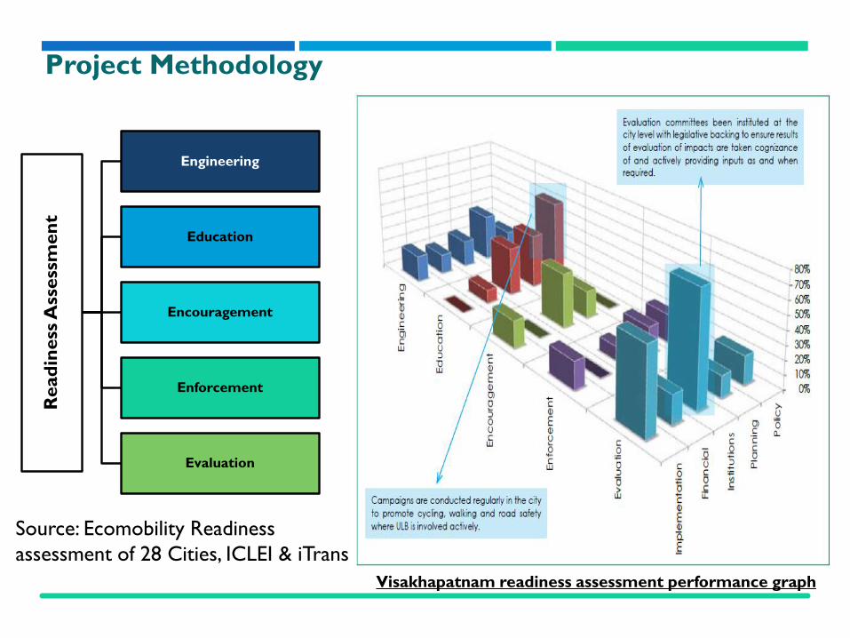
Read
iness
Ass
ess
men
t
Engineering
Education
Encouragement
Enforcement
Evaluation
Visakhapatnam readiness assessment performance graph
Project Methodology
Source: Ecomobility Readiness
assessment of 28 Cities, ICLEI & iTrans

Enable

Distribution of Functions at Various Levels of
Government
Level of Authority Planning and
Policy
Infrastructure Construction and Implementation
Operations Monitoring and Evaluation
National level
State level
City/ Metropolitan level

Strategies to Build an Enabling Environment
The Vision for an NMT friendly Vizag
Integrate land use and transit: Encourage mixed use planning in all new development areas accompanied by high density development along major transit corridors. Build/retrofit roads with walking infrastructure: All 430 kms of arterial and sub-arterial roads should be upgraded with walking infrastructure built as per ‘Urban Road Codes, 2012’ Build/retrofit roads with cycling infrastructure: In keeping with the VUDA Master Plan, all roads with a proposed ROW of 30m or higher, should segregated cycle tracks. Beach road should be equipped with a cycling track and bicycle parking facilities. Build a PBS network: In keeping with the NMT master plan, a PBS network having a 3km radius coverage around the main public transit lines (the proposed Metro and BRT) and feeder lines should be built. Integrate first and last mile needs of Transit: NMT infrastructure upgradation must be given priority in the transit influence zones accompanied by multiple transit opportunities for efficient last mile connectivity.

The Plan and Design

The Principles of NMT Network Planning
These guidelines have guided the NMT plan of Vishakhapatnam

The NMT Network Plan
• The network design will have five main requirements –Coherence, Directness, Attractiveness, Safety and Security and Comfort.
• The plan proposal should include routes and links for segregated cycle tracks and pedestrian footpaths on arterial roads, location of traffic calming measures etc. The plan should look out for missing links.
Source: iTrans

Proposed Street Hierarchy
• The different road widths, with different functions need to be designed differently to integrate pedestrian facilities within them.
• Providing footpaths and cycle tracks or lanes on both sides of roads is desirable.
• Footpaths and cycle tracks or lanes need to be constructed especially near schools, bus stops and along the main roads.
The minimum design width for footpaths and cycle tracks
are as presented:
Effective capacity as per LOS C inpersons per/min counted over15 min
Effective width of footpath (m)
23-50 1.5
58-83 2.5
81-116 3.5
115-165 5.0
Source: Urban Road Codes, 2012

Key Idea - Integrating Land Use and Transport –Accessible Cities
Land use and transport integration in a city can only happen by promoting
mixed use development. This would result in growth of population density in the
city area since people would stay closer to their jobs.
Following is a picture explaining this scenario. The
commercial landuse is developed along the main road
Source: iTrans

• The LCMP envisaged groeth patterns in the city along the commercial area.
• According to the LCMP, the proposed 3 growth centres are -Madhurawada, Pendurtiand Gajuwaka
Source: iTrans
The Growth Centres in the City

Source: iTrans
500m Buffer around the social, institutional and recreational
zones
• Specific care needs to betaken to ensure that allthe school zones areaccessible by walk andcrossings in these zonesare safe and well designedas a lot of studentpopulation is crossingthese areas.
• The social, institutionaland recreational zones inthe cities are identified,earmarking them forpriority intervention ofpedestrian crossings.

Proposed NMT Infrastructure
The map here showsthe Proposed NMTdesign (i.e. for bothwalking and cycling) inthe city which is basedon the road hierarchyand functions on thevarious roads.
The detailed mappingis presented further
Source: iTrans

Cycling Infrastructure
Source: iTrans
On the arterial roads withROW more than 30m,segregated cycle tracks areneeded to separate thecyclists from high speedmotorised traffic.
All roads with a proposedROW of 30m or higher, asper the VUDA MasterPlan, are identified for theprovision of segregatedcycle tracks.

Walking Infrastructure
Source: iTrans
Currently, only 78kmsout of the 430 kms ofarterial and sub-arterialroads in the city havesome kind of footpathspresent.
This should be upgradedto the entire 430 kmstretch over the course oftime and in the long runall roads, including thecollector and access roadsneed to be pedestrianfriendly.

Public Bike Sharing (PBS)PBS is a public transportation systembased on cycles, which are generallystored in a closely spaced network ofstations.
With a smart card or any other form ofidentification, a user can check out abicycle from a station and return it toany other station.
The central concept of these systems isto provide free or affordable access tocycles for short distance trips in anurban area as an alternative tomotorized public transportation orprivate vehicles.

PBS in VizagIn the case of Vizag, under theNMT master plan proposes a 3kmradius coverage of the PBS systemaround the main public transitlines (the proposed Metro andBRT) and feeder lines. Thiscoverage, as seen in the Figurehere, covers almost the entire cityin blue by cycle share.
One of the end line location(which can be seen in light peachcolour) it was found that duelonger cycling distance frompublic transit and the hillygradient.

Other than this, as GVMC is interested in developing a Public Bicycle Sharing (PBS) scheme to promote cycling further in the city. Two networks have been identified as part of LCMP which can act as a pilot for the implementation of PBS in the city and are shown in the following
Core Area Gaujuwaka Area
Pilot for the implementation of PBS

The First and Last Mile Needs of Transit
The first and last mile connection to transit is crucial. Biking andwalking provide important connections to public transportation.
Transit systems usually involve some multi modal connection in order toget a person from point to point. This difference is sometimes referred toas the “first-and-last mile” problem.
Improving the NMT-transit link is an important part of makingwalking and bicycling a part of daily life in Vizag.

In Vizag, a 30 km NMT and IPT access network to the BRT corridors has also been identified in the NMT Network Plan.
Routes are selected in such a way that they integrate the various mass transit corridors and also provide access to these corridors for the entire city..
The First and Last Mile Needs of Transit in Vizag
These routes also provide the best possible access by walk, cycle, auto-rickshaw and city bus
Identifying signature projects
Implementation of some Cycle lanes, Foot paths and Public BicycleSchemes in Visakhapatnam City could become signature projects tocreate interest in interventions for NMT.
Two projects are proposed under this:
Cycling highway along the beach road
Accessibility design for influence areas of the proposed metro station
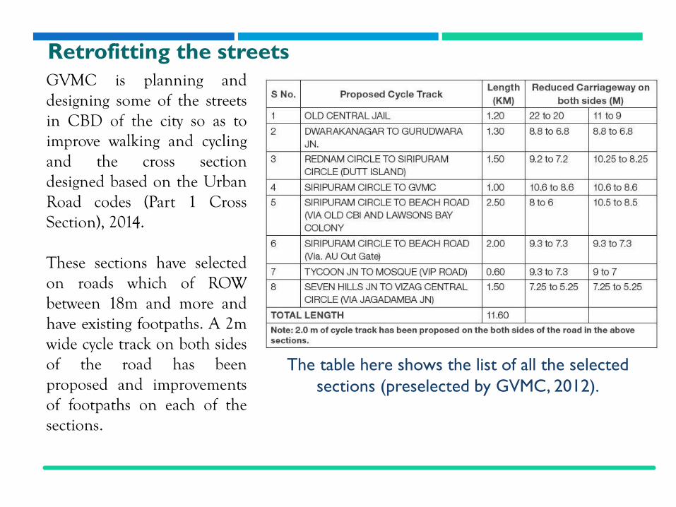
GVMC is planning anddesigning some of the streetsin CBD of the city so as toimprove walking and cyclingand the cross sectiondesigned based on the UrbanRoad codes (Part 1 CrossSection), 2014.
These sections have selectedon roads which of ROWbetween 18m and more andhave existing footpaths. A 2mwide cycle track on both sidesof the road has beenproposed and improvementsof footpaths on each of thesections.
Retrofitting the streets
The table here shows the list of all the selected
sections (preselected by GVMC, 2012).

Locations of these selected sections
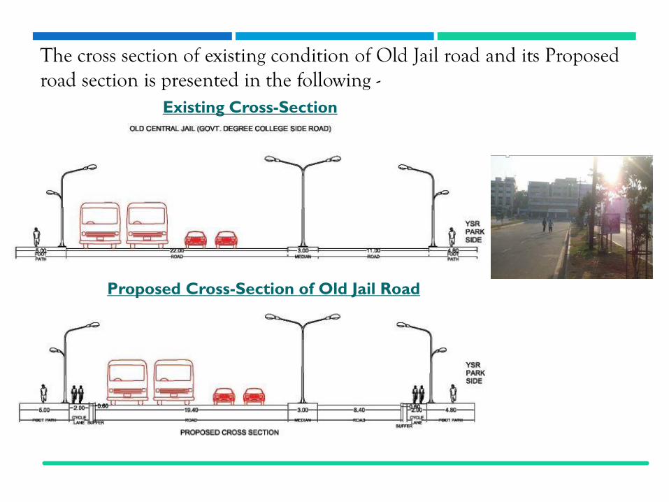
The cross section of existing condition of Old Jail road and its Proposed road section is presented in the following -
Existing Cross-Section
Proposed Cross-Section of Old Jail Road

Restructuring intersections for less conflicts
In Visakhapatnam city, the intersectionrestructuring is required for safer traveland reduce accidents at few intersections.
One of such intersection is shown below
in the picture.
There may be two major typesthat can be designed dependingon the location and type of theintersection:
• Roundabouts• Signalized Junctions

Safety and Security
The object of traffic calming is to modify driver behavior, control vehicle speeds and, in some circumstances, to reduce the volume of traffic.
This reduces danger from traffic and can enable users, including children, to reclaim the streets as social places where walking and cycling can be safer.
Some of the traffic calming techniques are Road bumps, Chicanes are curb extensions or edge islands and rumble strips.

Universal access and inclusion:
There can be a lot of requirements in addition to basic facilities require by different NMT users. The key provisions that are required for universal design are:
• Ramps on to sidewalks for easy movement of wheelchairs
• Bridges and tunnels with ramps at appropriate slopes or elevators
• Textured sidewalks to direct visually impaired
• Audible signals in at-level crossings.

Non-motorized Design and Planning Guidelines, 2014 gives a summary of all the Non-motorized signage to be used.


Designing for site specific conditions

Public convenience
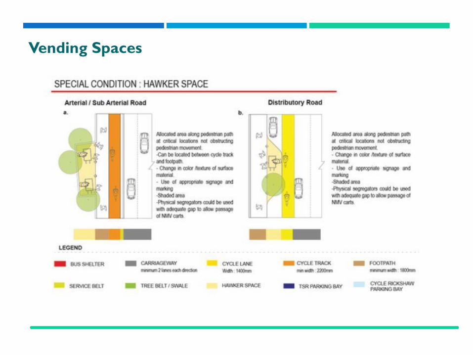
Vending Spaces

Invest
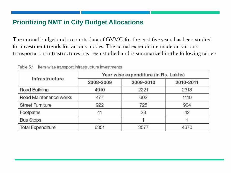
Prioritizing NMT in City Budget Allocations
The annual budget and accounts data of GVMC for the past five years has been studied for investment trends for various modes. The actual expenditure made on various transportation infrastructures has been studied and is summarized in the following table -
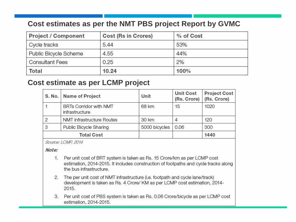
Cost estimates as per the NMT PBS project Report by GVMC
Cost estimate as per LCMP project

Alternative Financing Options
• State transport duties revenue reallocation – state government should earmark afixed portion (for NMT infrastructure provision) of revenue collected fromimposing various transport duties like MV licencing, octroi etc.
• The, KfW Development Bank or the German development bank as part of theKfW banking group is responsible for Financial Cooperation with developingcountries. KFW has shown keen interest in facilitating a loan for Public transitand NMT upgradation in Vizag.
• GVMC can allocate municipal budget for Non-motorized infrastructureimplementation and phase the network according to the funds available.
• Advertisement revenue – government should formulate a committee forintegration of advertisement revenue, from different sources like bus shelters,buses, road space etc., for funding parts of NMT infrastructure like guardedbicycle parking system, PBS system etc.
• NMT fund – state government should establish the NMT fund to promote theimplementation of NMT projects and assist Municipalities in funding NMTrelated road infrastructure improvement.
• Visakhapatnam Transportation Fund can be proposed for Vizag which couldbecome the financing tool to fund various non-motorized projects.
Implement

Organizational Framework Roles & Responsibilities

Community Engagement and Outreach
• Posting information on the GVMC website, running display ads in thenewspaper and public buildings, being interviewed on local radio shows andrunning public service announcements on the radio before public meetings.
• Hosting five public meetings in different locations throughout thecommunity to explain the project, answer questions and encourage people todraw routes they use, wish to use, and desire to be improved as they walk, bikeor use other non‐motorized transportation to get around their neighborhoodsand the community.
• Contacting and/or holding meetings with agencies or stakeholder groupssuch as the RWAs, Bicycle Club, TPCO, AMC, UD etc.
• Developing a project questionnaire to solicit written, mapped and emailedcomments and ideas on walking and biking destinations, missing links, safetyconcerns and other obstacles along the routes.

Project Management and Supervision
Planners/designers should produce a set of key guidelines as instructions for the agency/ team implementing and executing the design.
Transfer of a well-conceived NMT infrastructure plan on site, demands good communication between design agency, project managers and the contractors in order to explain instruction on use and interpretation of drawings.
• Preparation of Construction/Working Drawings
• Project Manager and Quality Surveyor
• Site Layout and Inspection• Site Inspection Procedures

Enforcement
Enforcement is needed against violations of motorized vehicles entering sidewalks and cycle tracks, parking on them, over speeding, traffic signal violations, etc.
Some, enforcing strategies need to be replicated in others to promote and safe guard NMT facilities.
Some of enforcement strategies are suggested as follows-• Stationing of trained policemen or marshals at each entry to cycle lane/track
• Policing and citations at junctions, towards the end of cycle paths.
• Improvement of the enforcement of speed limits and other safety related measures
• Recording of violations for secondary fines and citations using video cameras

Monitoring and Evaluation
After the NMT infrastructure in the city is laid down, there is a need to monitor the facilities at regular intervals.
The strategies to me followed by the M & E team should be as follows
• Focus on direct outcomes of the projects that have been carried out. In that case it is important to pay attention to the development of knowledge, arguments and instruments.
• Focus on the internalization of the results of the projects in policy and plans of the target groups.
• Assess the impacts achieved by the project as per pre-developed quantitative verifiable indicators.

Thank You


![77023554-1 iTrans Manual en Rev12 WE[2]GAS](https://static.fdocuments.us/doc/165x107/55cf9862550346d033974f92/77023554-1-itrans-manual-en-rev12-we2gas.jpg)

![[XLS] · Web viewSheet3 Sheet2 Sheet1 Sy. No. 17/8, Plot No. 62, Jaggarajupeta, Gajuwaka, Visakhapatnam Sy. No. 64/11B, Plot No. 59, Bhavani Nagar, Peda Gantyada, Gajuwaka, Visakhapatnam](https://static.fdocuments.us/doc/165x107/5adc679e7f8b9a595f8b7a07/xls-viewsheet3-sheet2-sheet1-sy-no-178-plot-no-62-jaggarajupeta-gajuwaka.jpg)
![Self-driving cars: The next revolution - University of Washingtonfaculty.washington.edu/jbs/itrans/self_driving_cars[1].pdf · 2012-08-20 · 4 Self-driving cars: The next revolution](https://static.fdocuments.us/doc/165x107/5f0ed56a7e708231d4412986/self-driving-cars-the-next-revolution-university-of-1pdf-2012-08-20-4-self-driving.jpg)