Visually enabled business processes to enrich the user experience
46
© 2013 SAP AG. All rights reserved. 1 A collaboration of: Visually Enabled Business Processes to Enrich the User Experience Kevin Morrow Product Management Utilities
-
Upload
robgirvan -
Category
Technology
-
view
83 -
download
2
description
Transcript of Visually enabled business processes to enrich the user experience

© 2013 SAP AG. All rights reserved. 1 A collaboration of:
Visually Enabled Business Processes to
Enrich the User Experience
Kevin Morrow
Product Management Utilities

© 2013 SAP AG. All rights reserved. 2
Legal Disclaimer
The information in this presentation is confidential and proprietary to SAP and may not be disclosed without the
permission of SAP. This presentation is not subject to your license agreement or any other service or subscription
agreement with SAP. SAP has no obligation to pursue any course of business outlined in this document or any related
presentation, or to develop or release any functionality mentioned therein. This document, or any related presentation
and SAP's strategy and possible future developments, products and/or platforms directions and functionality are all
subject to change and may be changed by SAP at any time for any reason without notice. The information on this
document is not a commitment, promise or legal obligation to deliver any material, code or functionality. This document
is provided without a warranty of any kind, either express or implied, including but not limited to, the implied warranties of
merchantability, fitness for a particular purpose, or non-infringement. This document is for informational purposes and
may not be incorporated into a contract. SAP assumes no responsibility for errors or omissions in this document, and
shall have no liability for damages of any kind including without limitation direct, special, indirect, or consequential
damages that may result from the use of this document. This limitation shall not apply in cases of intent or gross
negligence.
All forward-looking statements are subject to various risks and uncertainties that could cause actual results to differ
materially from expectations. Readers are cautioned not to place undue reliance on these forward-looking statements,
which speak only as of their dates, and they should not be relied upon in making purchasing decisions.
© 2013 SAP AG. All rights reserved. 3
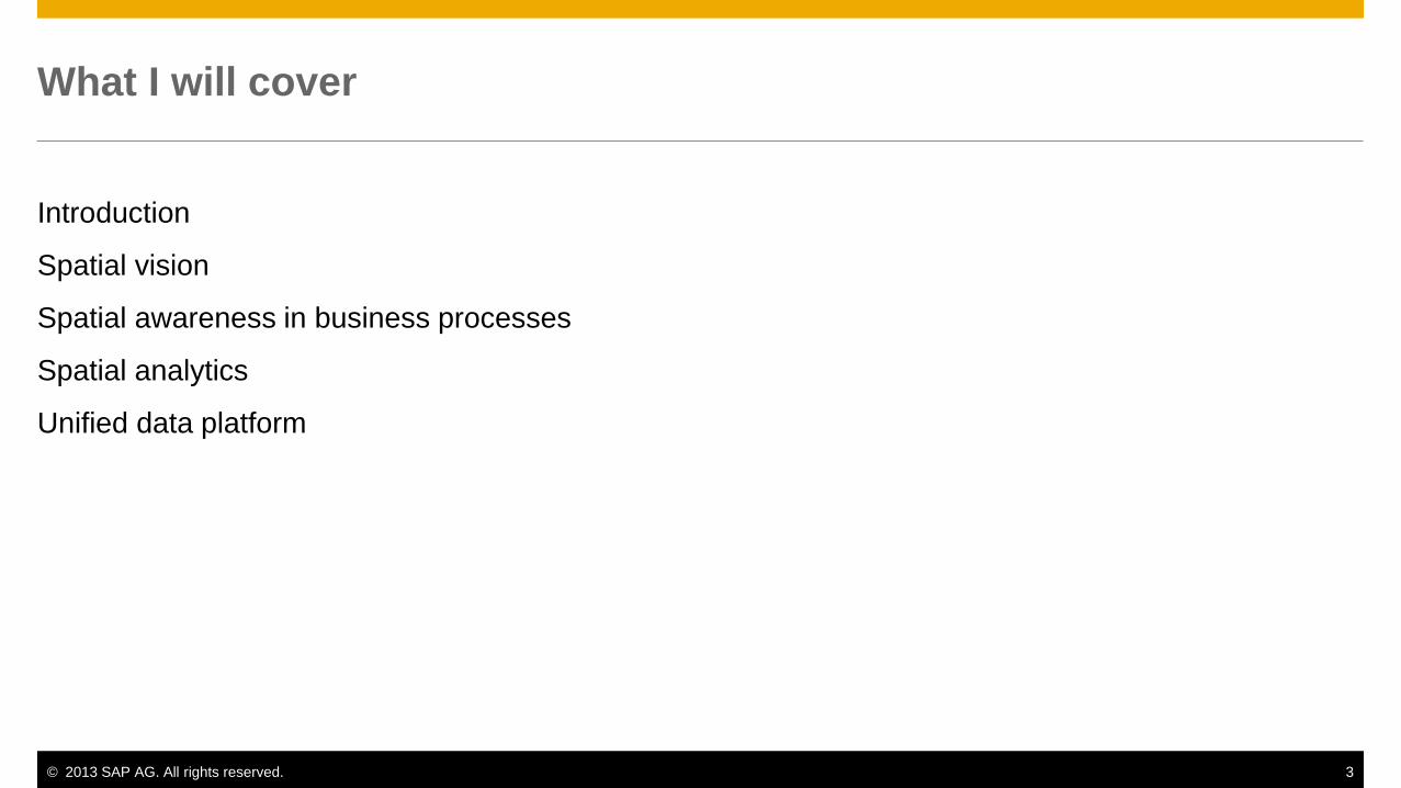
What I will cover
Introduction
Spatial vision
Spatial awareness in business processes
Spatial analytics
Unified data platform

© 2013 SAP AG. All rights reserved. 4
In today’s world of Big Data
You need to manage all types of data
80% of all data contains some reference to
geography*
100% of all businesses operate in a
geographic context
* Franklin, Carl and Paula Hane, “An introduction to GIS: linking maps to databases,” Database. 15 (2) April, 1992, 17-22

© 2013 SAP AG. All rights reserved. 5
What if you could improve the
value of business data by….
Enriching it with geographical context,
Visualizing its shape, and
Presenting it in real-time…

© 2013 SAP AG. All rights reserved. 6
…to improve business efficiency and decision-making
while reducing costs?
Humans have enormous visual bandwidth
for understanding multi -dimensional data “Visual quality metrics and human perception” Ben Schneiderman, ACM 2010
© 2013 SAP AG. All rights reserved. 7
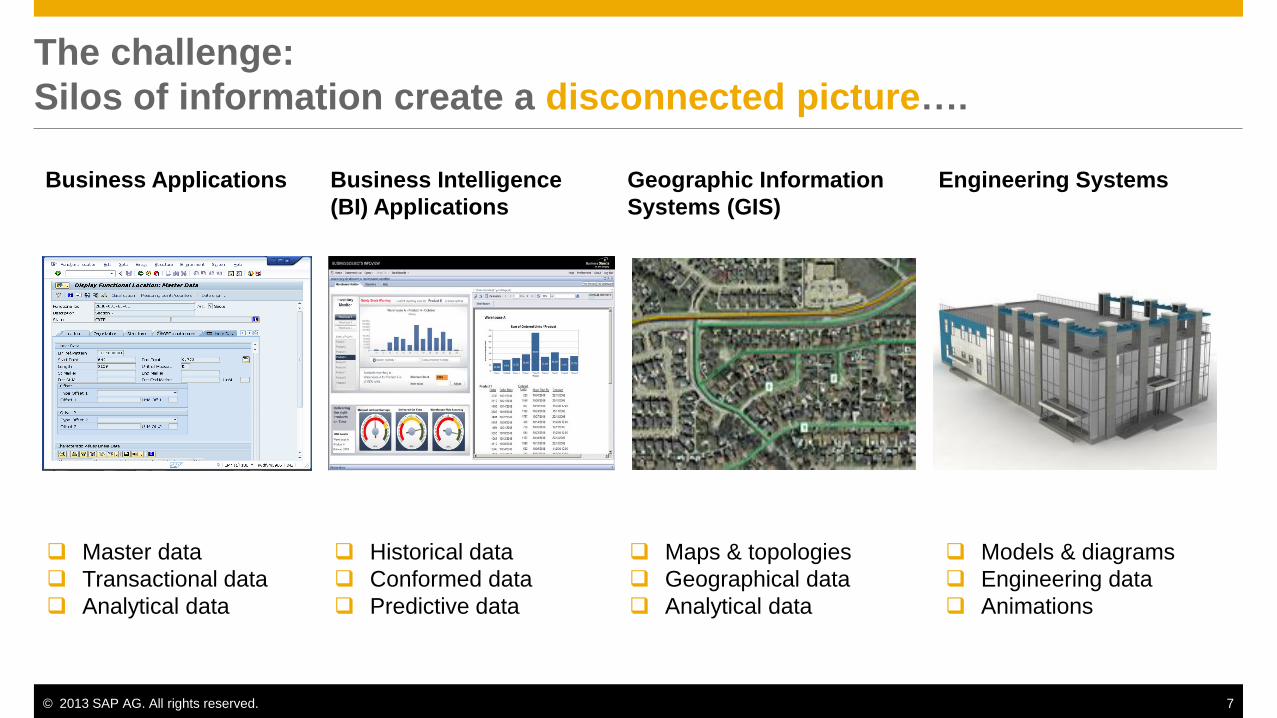
The challenge:
Silos of information create a disconnected picture….
Business Applications
Geographic Information
Systems (GIS)
Engineering Systems
Master data
Transactional data
Analytical data
Maps & topologies
Geographical data
Analytical data
Models & diagrams
Engineering data
Animations
Business Intelligence
(BI) Applications
Historical data
Conformed data
Predictive data

© 2013 SAP AG. All rights reserved. 8
Spatial systems
Our Customers have struggled with Important Questions
SAP unwittingly has been part of the “problem”
2
3
4
1. Which spatial system has my data and
which version ?
2. How do I sync data between business
and spatial systems ?
3. How do I access my business data from
my spatial client tools ?
4. How do I merge business and spatial
data with my operations systems ?
5. How do I connect and sync spatial data
to mobile devices ?
6. How to I provide web access of data in
multiple systems
1
6
5

© 2013 SAP AG. All rights reserved. 9
Manage business processes
within geographic or 3D
visualization context
Enrich analytics
with geographic
and 3D visualizations
Streamline data processing
with a unified platform
Increase the value of your business data
The E2E spatial business process
© 2013 SAP AG. All rights reserved. 10
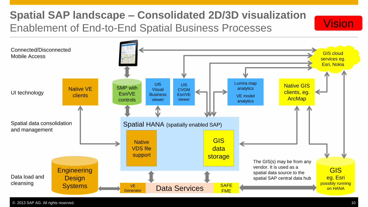
Spatial HANA (spatially enabled SAP)
Spatial SAP landscape – Consolidated 2D/3D visualization
Enablement of End-to-End Spatial Business Processes
Engineering
Design
Systems
Data load and
cleansing
Spatial data consolidation
and management
Native
VDS file
support
SMP with
Esri/VE
controls
Connected/Disconnected
Mobile Access GIS cloud
services eg.
Esri, Nokia
Lumira map
analytics
VE model
analytics
UI5
CVOM
Esri/VE
viewer
Native GIS
clients, eg.
ArcMap UI technology
Data Services VE
Generator
GIS eg. Esri
possibly running
on HANA SAFE
FME
GIS
data
storage
Native VE
clients
UI5
Visual
Business
viewer
Vision
The GIS(s) may be from any
vendor. It is used as a
spatial data source to the
spatial SAP central data hub

© 2013 SAP AG. All rights reserved. 11
Spatial and Visualization Solutions
From SAP and partners
Applications & Analytics
Es
ri A
rcG
IS f
or
Serv
er
Information Management
Real-time Data Management
Geographic enablement of applications, mobile, BI Map
Co
nte
nt &
Serv
ices
(e.g
. No
kia
HE
RE
, To
m T
om
, Es
ri)
SAP Visual
Business
SAP Visual
Enterprise (3D)
SAP BusinessObjects BI
(Visual SDK) Geo.e
framework
SAP Mobile
Platform
SAP HANA
SAP Enterprise Asset
Management
SAP Real Estate
Lifecycle
Management
SAP Transportation
Management SAP BusinessObjects
Integration for Esri GIS
SAP Work
Manager SAP Lumira
Spatially-enabled
Examples……
SAP Data Services

© 2013 SAP AG. All rights reserved. 12
Why SAP?
Increase the value of business data
Manage business processes
within geographic or 3D
visualization context
Enable faster decision making
with visual insight
Increase understanding of what,
where, why, and how
Deliver new insight to business
users on laptops, tablets, or
smart phones
Streamline business, spatial
& visual data processing
Improve productivity by
embedding maps in
applications
Reduce ambiguity with
visualizations
Gain contextual awareness of
real-time situations
Enrich analytics with geographic
and 3D visualizations
Accelerate speed of complex
data processing and analysis
Ensure trust in information with
complete and accurate data
Seamlessly deploy geo-content
from leading providers

© 2013 SAP AG. All rights reserved. 13
Customer Use Cases:
Increasing Business Data With Spatial & Visualization Content
Rapidly identify high-risk
assets close to
structures and people
Predict maintenance
from GPS data
embedded in tires
Improve field service
with correct addresses &
geo-location

© 2013 SAP AG. All rights reserved. 14
Manage Business Processes
within Geographic and
3D Visualization Context

© 2013 SAP AG. All rights reserved. 15
Real
Estate
Management
Field Workforce
Management
Customer
Relationship
Management
Public Sector Transportation
Industries
Retail and
Consumer
Products
Energy
& Resources
Spatially-
Enabled
Business
Processes
Financial
Services Manufacturing
Maintenance
Logistics &
Routing
Risk
Management
Enhance Business Processes with Geographic Content Enhance operational efficiency
Embed maps and spatial content in
SAP enterprise applications to improve
business processes
Provide intuitive spatial 5D (X,Y,Z,
time, data) navigation
Extend spatially-enabled business
processes to field workers
Add location as a critical attribute to
analytics to drive better decision
making
Leverage existing investments in
Geographic Information Systems (GIS)
and CAD systems
Asset
Management

© 2013 SAP AG. All rights reserved. 16
Geographical Enablement of SAP ERP Enhance SAP applications to display spatial data
A services package offered by SAP – built in partnership
with Esri – as a framework to geo-enable master data
and transactional data from business processes that run
in SAP ERP
GEO.e uses a dedicated Esri ArcGIS for Server to store
geometry related to SAP information
Geo.eXplorer View that enables business users to start
processes, visualize, filter, search for objects on a map
(functional location, equipment, linear assets,
notifications and work orders)
API’s that enable integration with Esri ArcGIS for Server
Gain geographical insight about objects on map
Increase productivity and operational efficiency
Optimize planning and improve maintenance
Increase compliance with regulations
What is GEO.e?
Key capabilities
GEO.e
framework
Esri ArcGIS
for Server SAP ERP
Geo.eXplorer
View
SAP Enterprise
Asset
Management
SAP Real
Estate
Lifecycle
Management
Geo.eXplorer
View
Spatially-enabled,
SAP ERP applications
SAP HANA Value

© 2013 SAP AG. All rights reserved. 17
Example: SAP Enterprise Asset Management Manage assets within context of location
Embed spatial content within SAP
application
Manage physical assets within context of
location
Production equipment
Machines
Vehicles, etc.
Seamlessly switch between SAP UI and
spatial view
Visualize, filter, search for assets on map
View (drill-down through) multiple map
layers

© 2013 SAP AG. All rights reserved. 18
Business objects in SAP EAM Use case - Linear Asset Management
I know it exists but ???
What does this pipeline section look like?

© 2013 SAP AG. All rights reserved. 19
Business objects in SAP EAM Integration of LAM and GIS data – Enhanced visualization

© 2013 SAP AG. All rights reserved. 20
Example: SAP Real Estate Lifecycle Management Manage mining leases from exploration, operation & reclamation
Embed spatial content within SAP
application
Manage real estate assets within context
of location
Parcels
Mining leases
Land deeds, land rights
Buildings
Seamlessly switch between SAP UI and
spatial view
Visualize, filter, search for assets on map
View (drill-down through) multiple map
layers

© 2013 SAP AG. All rights reserved. 21
Integration with native GIS clients Esri ArcMap

© 2013 SAP AG. All rights reserved. 22
SAP Visual Business toolbox for SAP Business Suite Deliver intuitive navigation through business data
UI toolbox (SDK) that enables rapid building of interactive
2D, 3D, and map-based graphics that can be embedded in
SAP and non-SAP applications
Visualize applications in real-time
Easily adjust UI views as business needs change
Make informed decisions based on visual data
Examples: customer service analysis, logistics analysis,
plant engineering oversight, replenishment management
SAP Visual Business
(UI toolbox)
SAP ERP Non-SAP
Visually-enabled, SAP applications*
Custom
Applications
SAP Transportation
Management
SAP HANA
Visualization: Geographical 2D & 3D business,
transactional, fully interactive and in real-time
Configuration: Independent of map provider
configuration without development
Pre-built UI integrations: SAP GUI, WebUIF, Web
Dynpro, FPM, UI5
Simple API in ABAP & JavaScript for rapid development
* Examples: SAP Transportation Management, SAP Event Management, SAP
Extended Warehouse Management, SAP CRM, SAP Fraud Management, SAP
AppDesigner
What is SAP Visual Business?
Value
Key capabilities

© 2013 SAP AG. All rights reserved. 23
Example: Visualization in SAP Transportation Management Improve planning process for transporting goods
Embed visualizations within SAP
application
Track transportation of goods
Provide alternate routes
Project deliveries to centers
Create logistics network
Display visual relationships between
business objects from different tables
(e.g. trucks, orders) on a map
Use drag and drop to modify plans on
map
Zoom in or out to show more or less
details
© 2013 SAP AG. All rights reserved. 24
SAP Visual Enterprise for SAP Business Suite Integrate 3D visualizations with business data
A suite of solutions that can help unify plant, product, etc.
information across systems such as CAD, product lifecycle
management, enterprise asset management, manufacturing,
and ERP
Work instructions: Enable 3D animated, step-by-step,
language-independent, procedural instructions
3D publishing: Provide 3D model-based document
authoring and publishing to a variety of industry standard
2D and 3D formats
Spatial analytics: Use visual information for search, query,
and spatially-relevant analytics and reporting
Accelerate decision making by combining 3D visualizations
and business data
Improve efficiency with graphical animation of procedures
Facilitate proper procedure execution; improve technician
productivity
Reduce document authoring and publishing costs
SAP Visual Enterprise
Author
SAP Visual
Enterprise
Navigator
SAP Business Suite
CAD system
SAP Visual Enterprise
Generator
SAP Visual
Enterprise
Viewer
SAP Visual
Enterprise
Access
Create 3D animations inside
applications or documents
Translate CAD files to support
engineering, manufacturing,
maintenance
View & interact with
published content
Search by context &
metadata Generate reports / dashboards
to control assets
Key capabilities
Value
What is SAP Visual Enterprise?

© 2013 SAP AG. All rights reserved. 25
Overview of SAP Visual Enterprise Suite Use visualizations to understand and act
CAD Translation
Lightweight File
Generation
Automated Process
Creation
Asset Management
Asset Browse and
Search
Asset Version Control
Dashboards
Reporting and
Administration
High Performance
Model Fly-through
Spatial Query
Search by Context and
Metadata
Visual Business
Intelligence
3D Animations
Tech Document
Publishing
Photo-realistic Imagery
User Interface
Configurability
Collaboration
View and Mark-up
View 3D Models and
Animations
View 3D in
MS-Office & PDF

© 2013 SAP AG. All rights reserved. 26
Example: SAP Visual Enterprise in Research & Development Improve collaboration and reduce costs
Combine 3D CAD and business data to
support work processes
Create 3D animation and render rich
visual content in applications and
documents
View and interact with published content
Enable search and query against visual
information
Enable faster retrieval, analysis, and
understanding of information

© 2013 SAP AG. All rights reserved. 27
SAP Mobile Platform: Spatial Enhancement API Embed geospatial data in mobile applications
An Open UI API delivered via the SAP Mobile platform that
enables application integration and UX enrichment by
applying standard models and protocols delivered by SAP to
interact with data and screens
GIS integration: Create of client-side controls in UI to embed
geographical data from Esri ArcGIS for Server into mobile
applications
Native platform support: iOS, Android, Windows
Help business users
Find “Near Me”
Filter by functional location, equipment location
View work orders & notifications by location
Increase productivity and operational efficiency
Gain geographical insight about enterprise assets
Optimize planning and improve maintenance
Improve customer service
SAP ERP
SAP Mobile Platform
(Spatial enhancement API)
Esri ArcGIS
for Server
Spatially-enabled,
SAP ERP applications
Open UI
control
SAP
Work
Manager SAP
Service
Manager
Open UI
control
Spatially-enabled,
mobile applications
Planned Key capabilities
Value
What is the spatial enhancement API?

© 2013 SAP AG. All rights reserved. 28
Example: SAP Work Manager Help field workers to access business & spatial data in single view
Embed spatial content within SAP mobile
application
Manage work assets within context of
location
Work orders and notifications
Equipment
Functional Locations
Run natively on iOS, Android and
Windows
Visualize, filter, search for assets on map
View (drill-down through) multiple map
layers

© 2013 SAP AG. All rights reserved. 29
Enrich Analytics with
Geographic and 3D Visualizations

© 2013 SAP AG. All rights reserved. 30
Options for SAP BusinessObjects and Esri Integration Combining Business with Geospatial Information
SAP Offerings
SAP Lumira is planned to be the first product to support native Esri integration
Other products such as Design Studio, Web Intelligence and Crystal Reports are planned to
follow
Partner Offerings
Galigeo, including the recently acquired assets from APOS Systems, Inc., enable Esri
integration for SAP Dashboards, SAP Web Intelligence, and SAP Crystal Reports
Esri is planning to release an add-on for SAP Dashboards and other SAP business
intelligence products that enables native integration

© 2013 SAP AG. All rights reserved. 31
Enterprise Location Intelligence
Combine business with geospatial information
SAP BusinessObjects BI Clients
Dashboards | Exploration | Reporting
SAP BusinessObjects BI Platform
APOS Location
Intelligence
Solution
Esri ArcGIS for Server
Fusion of business intelligence (BI) and
GIS
Power to drill, filter & analyze location
intelligence
Mash up geo maps with real-time analytics
Combine geospatial,
operational & analytical data
Bi-directional integration between SAP
BusinessObjects BI platform and Esri
ArcGIS for Server via APOS Location
Intelligence Solution

© 2013 SAP AG. All rights reserved. 32
SAP BusinessObjects BI Clients
Planned Integration Between SAP BOBJ, Esri and HANA Combining Business with Geospatial Information
SAP BusinessObjects BI Platform
HTML5 Visualization Platform (CVOM*)
3rd Party GIS & Map Container
Geospatial
Data Types &
Processing
ArcGIS
JavaScript
API
* Common Visualization Object Model

© 2013 SAP AG. All rights reserved. 33
SAP BusinessObjects BI Platform: Visualization SDK Embed common visualizations in BI tools or applications
Common Visualization Object Model (CVOM) is a
standard HTML5 visualization platform and SDK used by
SAP BusinessObjects BI clients and other applications to
deliver visualizations
Rich library of 50+ charts and visualizations
Overlay charts with geo-spatial data for location-based
insight
Support for mobile devices and next-generation Internet
browsers
SDK / API to customize existing charts and create new
visualizations
Improve decision making with high-impact visuals in BI
and applications
Assist business users in making sense of Big Data with
advanced visualizations
SAP HANA
SAP BusinessObjects BI Platform
(Visualization SDK CVOM)
SAP Lumira
Esri ArcGIS
for Server
APOS Location Intelligence
System
SAP ERP
SAP BusinessObjects
Dashboards SAP BusinessObjects
Explorer
Location intelligence
delivered via BI tools
Key capabilities
Value
What is the Visualization SDK?
© 2013 SAP AG. All rights reserved. 34
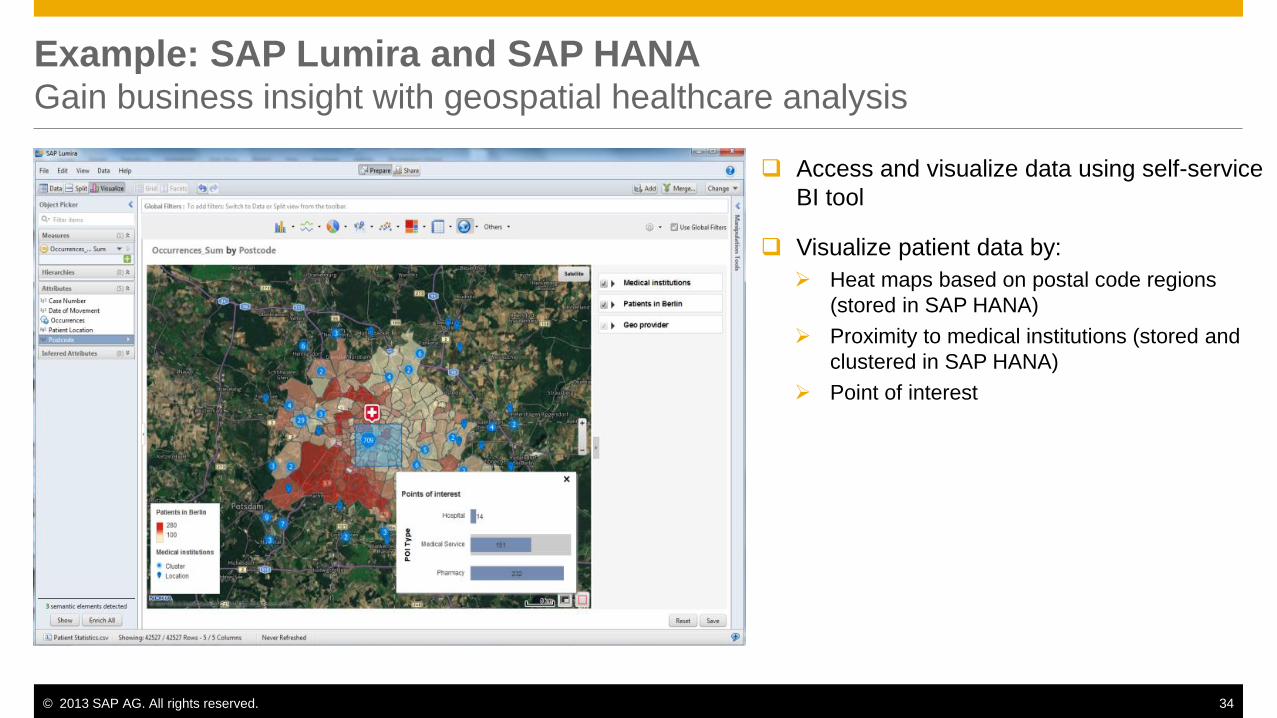
Example: SAP Lumira and SAP HANA Gain business insight with geospatial healthcare analysis
Access and visualize data using self-service
BI tool
Visualize patient data by:
Heat maps based on postal code regions
(stored in SAP HANA)
Proximity to medical institutions (stored and
clustered in SAP HANA)
Point of interest

© 2013 SAP AG. All rights reserved. 35
Add-On Product by Esri: “Esri Maps for SAP BusinessObjects”
Native BusinessObjects report creation

© 2013 SAP AG. All rights reserved. 36
Add-On Product by Esri: “Esri Maps for SAP BusinessObjects”
Define map content

© 2013 SAP AG. All rights reserved. 37
Add-On Product by Esri: “Esri Maps for SAP BusinessObjects”
Resulting Dashboard with integrated Map

© 2013 SAP AG. All rights reserved. 38
Streamline Data Processing
With a Unified Platform

© 2013 SAP AG. All rights reserved. 39
SAP HANA
Real-time Replication Services Data Services In-Memory Database
Planning and Calculation Engine R and Hadoop Integration Predictive Analysis & Business Function
Libraries
Information Composer and Modeling
Studio Spatial Processing Text Search & Text Analysis
SAP HANA A platform for a new class of real-time analytics and applications
Real-time Applications
Real-time Analytics
Real-time Platform
Operational Reporting
Core Business
Acceleration
Database
Data Warehousing
Planning and
Optimization
Mobile
Predictive & Text
Analytics on Big Data
Sensing
and Response
Cloud

© 2013 SAP AG. All rights reserved. 40
SAP HANA Spatial Data Processing Develop and deploy spatially-enabled analytics and applications
In-memory platform for analytics & applications,
including real-time processing of business and spatial
data
Optimized spatial processing: Store and process
spatial data
Geo-content and geo-services: Native, seamless
integration with map content and services
Spatial application development platform: Quickly
develop and deploy spatially-enabled applications
Implements ISO/IEC 13249-3 standard and Open
Geospatial Consortium (1999 SQL/MM standard)
Real-Time
Data
Spatial Data
Business
Data Spatial
Data
Types
Spatial
Functions
Calc
Model /
Views
Geo-
Content
Geo-
Services
Column
Spatial
Storage
SAP
HANA OLTP Analytics Planning Predictive Text Spatial
Real-time processing of large volumes of business and
spatial data for improved efficiency & insight
Key capabilities
Value
What is SAP HANA, spatial data processing?

© 2013 SAP AG. All rights reserved. 41
Example: SAP HANA Spatial Data Processing Rapidly identify high-risk assets close to structures & people
Leverage native geo-spatial capabilities to
store, pre-process, compute, and analyze
huge volumes of spatial data in real-time
Combine spatial data with historic
operational data for new insights
Use spatial visualizations to identify and
select assets at risk
Enable ad-hoc queries to identify high-risk
assets to:
Reduce outages
Reduce maintenance
Minimize catastrophic failures

© 2013 SAP AG. All rights reserved. 42
SAP Data Services Integrate, cleanse, and enhance with geo-coding
A foundation to move, improve, and govern data from a
variety of data targets and sources
ETL & ELT: Extract, load, transform data from a variety of
data sources
Data quality management: Parse, correct, validate, match,
de-duplicate data, and consolidate records
Address cleansing: Partner with 30+ postal authorities
Geocoding: Associate geographic coordinates (latitude &
longitude) with addresses and zip codes
Partnerships: Nokia Navteq, TomTom, and more
Data quality assessment: Continuously monitor the quality
of data based on reusable business rules
Access relevant data regardless of data type or source
Improve data quality for more effective decision making and
business operations
SAP HANA
Esri
ArcGIS
for
Server
Spatial Data
Analytical Data
Engineering Data
SAP Data Services
Geo-content
Transaction Data
• Load
• Cleanse
• Enhance (geocode)
Key capabilities
Value
What is SAP Data Services?
Cloud based
GIS services
eg. Nokia,
Esri
© 2013 SAP AG. All rights reserved. 43
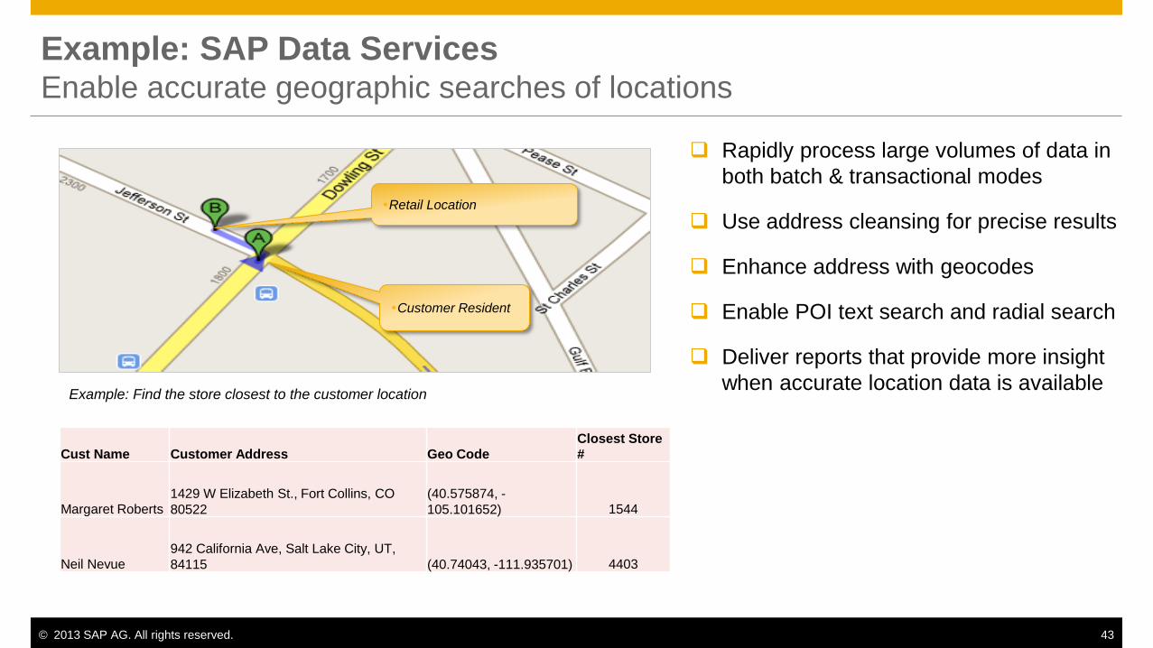
Example: SAP Data Services Enable accurate geographic searches of locations
Example: Find the store closest to the customer location
Customer Resident
Retail Location
Cust Name Customer Address Geo Code Closest Store
#
Margaret Roberts 1429 W Elizabeth St., Fort Collins, CO
80522
(40.575874, -
105.101652) 1544
Neil Nevue 942 California Ave, Salt Lake City, UT,
84115 (40.74043, -111.935701) 4403
Rapidly process large volumes of data in
both batch & transactional modes
Use address cleansing for precise results
Enhance address with geocodes
Enable POI text search and radial search
Deliver reports that provide more insight
when accurate location data is available

© 2013 SAP AG. All rights reserved. 44
Spatial HANA (spatially enabled SAP)
Spatial SAP landscape – Consolidated 2D/3D visualization
Enablement of End-to-End Spatial Business Processes
Engineering
Design
Systems
Data load and
cleansing
Spatial data consolidation
and management
Native
VDS file
support
SMP with
Esri/VE
controls
Connected/Disconnected
Mobile Access GIS cloud
services eg.
Esri, Nokia
Lumira map
analytics
VE model
analytics
UI5
CVOM
Esri/VE
viewer
Native GIS
clients, eg.
ArcMap UI technology
Data Services VE
Generator
GIS eg. Esri
possibly running
on HANA SAFE
FME
GIS
data
storage
Native VE
clients
UI5
Visual
Business
viewer
Vision
The GIS(s) may be from any
vendor. It is used as a
spatial data source to the
spatial SAP central data hub

© 2013 SAP AG. All rights reserved. 45 A collaboration of:
Kevin Morrow Product Management Utilities
© 2013 SAP AG. All rights reserved. 46
Legal Disclaimer
The information in this presentation is confidential and proprietary to SAP and may not be disclosed without the
permission of SAP. This presentation is not subject to your license agreement or any other service or subscription
agreement with SAP. SAP has no obligation to pursue any course of business outlined in this document or any related
presentation, or to develop or release any functionality mentioned therein. This document, or any related presentation
and SAP's strategy and possible future developments, products and/or platforms directions and functionality are all
subject to change and may be changed by SAP at any time for any reason without notice. The information on this
document is not a commitment, promise or legal obligation to deliver any material, code or functionality. This document
is provided without a warranty of any kind, either express or implied, including but not limited to, the implied warranties of
merchantability, fitness for a particular purpose, or non-infringement. This document is for informational purposes and
may not be incorporated into a contract. SAP assumes no responsibility for errors or omissions in this document, and
shall have no liability for damages of any kind including without limitation direct, special, indirect, or consequential
damages that may result from the use of this document. This limitation shall not apply in cases of intent or gross
negligence.
All forward-looking statements are subject to various risks and uncertainties that could cause actual results to differ
materially from expectations. Readers are cautioned not to place undue reliance on these forward-looking statements,
which speak only as of their dates, and they should not be relied upon in making purchasing decisions.