VISUALIZING VENICE - Università Iuav di Venezia · stampa Grafiche Veneziane, Venezia (VE) dusty...
12
Università Iuav di Venezia Santa Croce 191 Tolentini 30135 Venezia www.iuav.it © Iuav 2012 Iuav giornale dell’università iscritto al n. 1391 del registro stampa tribunale di Venezia a cura del servizio comunicazione [email protected] ISSN 2038-7814 direttore Amerigo Restucci stampa Grafiche Veneziane, Venezia (VE) dusty display cases protecting hardly decipherable documents. Quite the contrary. The exhibition holds the sur- prise of finding the historian’s tools in step with the times. There’s everything that is needed to interpret events dyna- mically: maps, models, videos with mo- ving images; rigorous reconstructions of the city’s changes; bird’s-eye views of the cantieri and their histories. The exhibition has been conceived as enthralling journey through time, a learning experience that lets visitors track events and stratifications, recom- posing the tiles of the grand mosaic of Venice’s millenary history. Professor Donatella Calabi has set a challenge and likens the research now on display as a still photograph of a study just be- gun, a snapshot of a work in progress. These partial results, however, test and validate the use of a new methodology for studying urban history, an appro- ach that will be necessary for resear- chers of tomorrow. That is, of course, if they are willing to take urban history off the library shelves and let it beco- me part of the cultural heritage and identity of a community that recogni- zes itself in these stories. The exhibition panels documenting the histories of the cantieri are accom- panied by videos and an offline app (designed for an iPad), which—through the experiences of the professors and students who have participated in VV workshops—traces the parallel story of VV’s training program. *Visualizing Venice is a project in collaboration with Duke University (Durham–NC, USA), the Università degli Studi Padova–Department of Civil, Structural, and Environmental Engineering (ICEA), and Nesting Scrl of Venice. The project was founded in 2010 by Prof. Donatella Calabi (Iuav) and Prof. Caroline Bruzelius (Duke) and has involved about twenty researchers over the last three years. The Study of Urban History Donatella Calabi If history is the “science of mastering the past and the consciousness of time, it has yet to be defined as a science of change, of transformation.” Jacques Le Goff Visualizing Venice aims at conceiving new ways of studying urban history that—without leaving a single stone in the philology of traditional documen- tary, cartographic, iconographic, and biblio-graphic tools unturned—can draw on the potential of today’s mul- timedia technology to piece together complex long-term events otherwise difficult to reconstruct. The research is based on two parallel hypotheses. 1) That the processes of transformation and movement which increasingly cha- racterize but have always conditioned the form and use of urban settlements can be best understood by combining the methods and interpretive techni- ques of various disciplines, and that the different areas of expertise dea- ling with the history of built works and open spaces, their uses, the institu- tions that backed them, the economic forces that made them possible, and the companies that used them can and must be brought together with the technological know-how capable of visualizing changes in access, rou- ting, perspectives, and fruition. 2) That anyone is capable of appro- priating knowledge about the forma- tion and successive stratification of the places in which they live, play, go to school or to work; that scholars of “urban history,” professional/research associations, and institutions respon- sible for conserving and transmitting memory (museums, libraries, archives) often investigate the transformations of physical urban space in sophisti- cated ways; but that, in both cases, it must be understood that today’s inter- locutor is a broad audience made up not only of specialists but, first and foremost, of citizens old and new; of children in search of their grandpa- rents “real” stories; of the elderly in pursuit of their memories; of newly or less recently arrived immigrants see- king the identity of the city in which they live; of decision-makers requiring support in sustaining local economies, protecting cultural heritage/building infrastructure, and managing touri- sm; of tourists curious to know how the cities they explore came to be and developed. The divisions between aca- demic disciplines make it hard to work collectively on bringing the history of institutions together with that of eco- nomics, society, and architecture. The history of the city, however, is built through the entanglement of these forces, and it is only on the basis of how they intertwine that the city can truly be studied. Visualizing Venice aims at studying long-term urban transformation by privileging dynamic considerations of space and time and the effects of movement; this exhibi- tion is a first step in disseminating its results. Visualizing Venice is focused on one exemplary case study—Venice, the lagoon city and its mainland, both as a whole and in some of its highly complex historical, institutional, eco- nomic, and morphological parts, over a chronological period spanning from the twelfth to the twenty-first century. It focuses on areas of the city in which the layering of many different inter- ventions and uses can be documen- ted: sites of power, markets, the naval shipyards, industrial developments, residences for foreigners and religious minorities, and places for viewing art. It demonstrates how buildings and institutions—such as hospitals, mar- kets, churches—interact with space, transforming flows and movement in a city. Is it possible to devise a de- scriptive and analytical tool that can map this? A tool that can then be applied to other cities and urban en- vironments? Do existing technologies for handheld devices make it possible to develop apps that can explain the city to a multitude of users? The singularity and exemplarity of Ve- nice—once a “world metropolis” and today the most extreme example of a monoculture based on tourism—provi- des a model for studying, visualizing, and integrating knowledge about urban transformation. While focused one particularly significant case study, Visualizing Venice also poses the pro- blem of the method’s comparability in completely different economic, institu- tional, and residential contexts. Giornale edito in occasione della mostra “Visualizing Venice new technologies for urban history” December 5 > 21, 2012 Cotonificio, sala Gino Valle Unità di ricerca “Memoria e Rappresentazione” numero a cura di issue edited by Alessandra Ferrighi The Exhibition Alessandra Ferrighi What will History say? History, sir, will tell lies. George Bernard Shaw, The Devil’s Disciple, 1897 Visualizing Venice, new technologies for urban history is the first exhibition en- tirely devoted to history to be mounted in the Gino Valle exhibition space at the Università Iuav di Venezia. The exhibition offers, on the one hand, a cross-section of the research of Visualizing Venice* focused on a new way of “making” history through the use of Information and Communi- cation Technologies (ICT) and, on the other, an opportunity to test just how effective the most innovative commu- nication systems can be in recounting urban transformation. The exhibition reconstructs VV’s rese- arch over the last three years through a series of “cantieri” (construction sites). Moving through the space, visitors can trace the history of certain parts of the city: the insulae of SS. Giovanni e Paolo and the Accademia, the areas of the Giardini della Biennale and the Arsenale. These sites have become the grounds on which to test a new way doing historical research: they are sites of major change and sites on which Venice is proving to be a future-orien- ted city, a city that is ready to try out new ways of being, reinterpreting and reconverting entire sections of its ur- ban fabric. The changes in these parts of Venice’s historical building tissue are staged—at both an urban and a building scale—in the dramatic spaces created by the niches of the exhibition gallery, allowing viewers to experien- ce urban transformation in both spa- ce and time. Visitors can observe the major changes in each area on a dual register through the relationships cre- ated between images from archival documents and digital reconstructions (2D maps and 3D models). Historical sources are seen in relation to inter- pretations and accompanied by the scanning of time through the phases considered most crucial to each area’s transformation. There’s nothing static in this exhibi- tion, nothing that brings up images of VISUALIZING VENICE new technologies for urban history Iuav : 123
Transcript of VISUALIZING VENICE - Università Iuav di Venezia · stampa Grafiche Veneziane, Venezia (VE) dusty...
Università Iuav di VeneziaSanta Croce 191 Tolentini30135 Veneziawww.iuav.it
©Iuav 2012
Iuav giornale dell’universitàiscritto al n. 1391del registro stampatribunale di Veneziaa cura del servizio [email protected] 2038-7814
direttoreAmerigo Restucci
stampa Grafiche Veneziane, Venezia (VE)
dusty display cases protecting hardly decipherable documents. Quite the contrary. The exhibition holds the sur-prise of finding the historian’s tools in step with the times. There’s everything that is needed to interpret events dyna-mically: maps, models, videos with mo-ving images; rigorous reconstructions of the city’s changes; bird’s-eye views of the cantieri and their histories. The exhibition has been conceived as enthralling journey through time, a learning experience that lets visitors track events and stratifications, recom-posing the tiles of the grand mosaic of Venice’s millenary history. Professor Donatella Calabi has set a challenge and likens the research now on display as a still photograph of a study just be-gun, a snapshot of a work in progress. These partial results, however, test and validate the use of a new methodology for studying urban history, an appro-ach that will be necessary for resear-chers of tomorrow. That is, of course, if they are willing to take urban history off the library shelves and let it beco-me part of the cultural heritage and identity of a community that recogni-zes itself in these stories. The exhibition panels documenting the histories of the cantieri are accom-panied by videos and an offline app (designed for an iPad), which—through the experiences of the professors and students who have participated in VV workshops—traces the parallel story of VV’s training program.
*Visualizing Venice is a project in collaboration with Duke University (Durham–NC, USA), the Università degli Studi Padova–Department of Civil, Structural, and Environmental Engineering (ICEA), and Nesting Scrl of Venice. The project was founded in 2010 by Prof. Donatella Calabi (Iuav) and Prof. Caroline Bruzelius (Duke) and has involved about twenty researchers over the last three years.
The Study of Urban HistoryDonatella Calabi
If history is the “science of mastering the past and the consciousness of time, it has yet to be defined as a science of change, of transformation.”Jacques Le Goff
Visualizing Venice aims at conceiving new ways of studying urban history that—without leaving a single stone in the philology of traditional documen-tary, cartographic, iconographic, and biblio-graphic tools unturned—can draw on the potential of today’s mul-timedia technology to piece together complex long-term events otherwise difficult to reconstruct. The research is based on two parallel hypotheses. 1) That the processes of transformation and movement which increasingly cha-racterize but have always conditioned the form and use of urban settlements can be best understood by combining the methods and interpretive techni-ques of various disciplines, and that the different areas of expertise dea-ling with the history of built works and open spaces, their uses, the institu-tions that backed them, the economic forces that made them possible, and the companies that used them can and must be brought together with the technological know-how capable of visualizing changes in access, rou-ting, perspectives, and fruition. 2) That anyone is capable of appro-priating knowledge about the forma-tion and successive stratification of the places in which they live, play, go to school or to work; that scholars of “urban history,” professional/research associations, and institutions respon-sible for conserving and transmitting memory (museums, libraries, archives) often investigate the transformations of physical urban space in sophisti-cated ways; but that, in both cases, it must be understood that today’s inter-locutor is a broad audience made up not only of specialists but, first and foremost, of citizens old and new; of children in search of their grandpa-rents “real” stories; of the elderly in pursuit of their memories; of newly or less recently arrived immigrants see-king the identity of the city in which they live; of decision-makers requiring
support in sustaining local economies, protecting cultural heritage/building infrastructure, and managing touri-sm; of tourists curious to know how the cities they explore came to be and developed. The divisions between aca-demic disciplines make it hard to work collectively on bringing the history of institutions together with that of eco-nomics, society, and architecture. The history of the city, however, is built through the entanglement of these forces, and it is only on the basis of how they intertwine that the city can truly be studied. Visualizing Venice aims at studying long-term urban transformation by privileging dynamic considerations of space and time and the effects of movement; this exhibi-tion is a first step in disseminating its results. Visualizing Venice is focused on one exemplary case study—Venice, the lagoon city and its mainland, both as a whole and in some of its highly complex historical, institutional, eco-nomic, and morphological parts, over a chronological period spanning from the twelfth to the twenty-first century. It focuses on areas of the city in which the layering of many different inter-ventions and uses can be documen-ted: sites of power, markets, the naval shipyards, industrial developments, residences for foreigners and religious minorities, and places for viewing art. It demonstrates how buildings and institutions—such as hospitals, mar-kets, churches—interact with space, transforming flows and movement in a city. Is it possible to devise a de-scriptive and analytical tool that can map this? A tool that can then be applied to other cities and urban en-vironments? Do existing technologies for handheld devices make it possible to develop apps that can explain the city to a multitude of users? The singularity and exemplarity of Ve-nice—once a “world metropolis” and today the most extreme example of a monoculture based on tourism—provi-des a model for studying, visualizing, and integrating knowledge about urban transformation. While focused one particularly significant case study, Visualizing Venice also poses the pro-blem of the method’s comparability in completely different economic, institu-tional, and residential contexts.
Giornale edito in occasione della mostra“Visualizing Venicenew technologies for urban history”December 5 > 21, 2012 Cotonificio, sala Gino Valle
Unità di ricerca “Memoria e Rappresentazione”
numero a cura diissue edited by Alessandra Ferrighi
The ExhibitionAlessandra Ferrighi
What will History say?History, sir, will tell lies.George Bernard Shaw, The Devil’s Disciple, 1897
Visualizing Venice, new technologies for urban history is the first exhibition en-tirely devoted to history to be mounted in the Gino Valle exhibition space at the Università Iuav di Venezia. The exhibition offers, on the one hand, a cross-section of the research of Visualizing Venice* focused on a new way of “making” history through the use of Information and Communi-cation Technologies (ICT) and, on the other, an opportunity to test just how effective the most innovative commu-nication systems can be in recounting urban transformation. The exhibition reconstructs VV’s rese-arch over the last three years through a series of “cantieri” (construction sites). Moving through the space, visitors can trace the history of certain parts of the city: the insulae of SS. Giovanni e Paolo and the Accademia, the areas of the Giardini della Biennale and the Arsenale. These sites have become the grounds on which to test a new way doing historical research: they are sites of major change and sites on which Venice is proving to be a future-orien-ted city, a city that is ready to try out new ways of being, reinterpreting and reconverting entire sections of its ur-ban fabric. The changes in these parts of Venice’s historical building tissue are staged—at both an urban and a building scale—in the dramatic spaces created by the niches of the exhibition gallery, allowing viewers to experien-ce urban transformation in both spa-ce and time. Visitors can observe the major changes in each area on a dual register through the relationships cre-ated between images from archival documents and digital reconstructions (2D maps and 3D models). Historical sources are seen in relation to inter-pretations and accompanied by the scanning of time through the phases considered most crucial to each area’s transformation. There’s nothing static in this exhibi-tion, nothing that brings up images of
V I SUA L I Z ING V EN I C E
new technologies for urban history
Iuav : 123
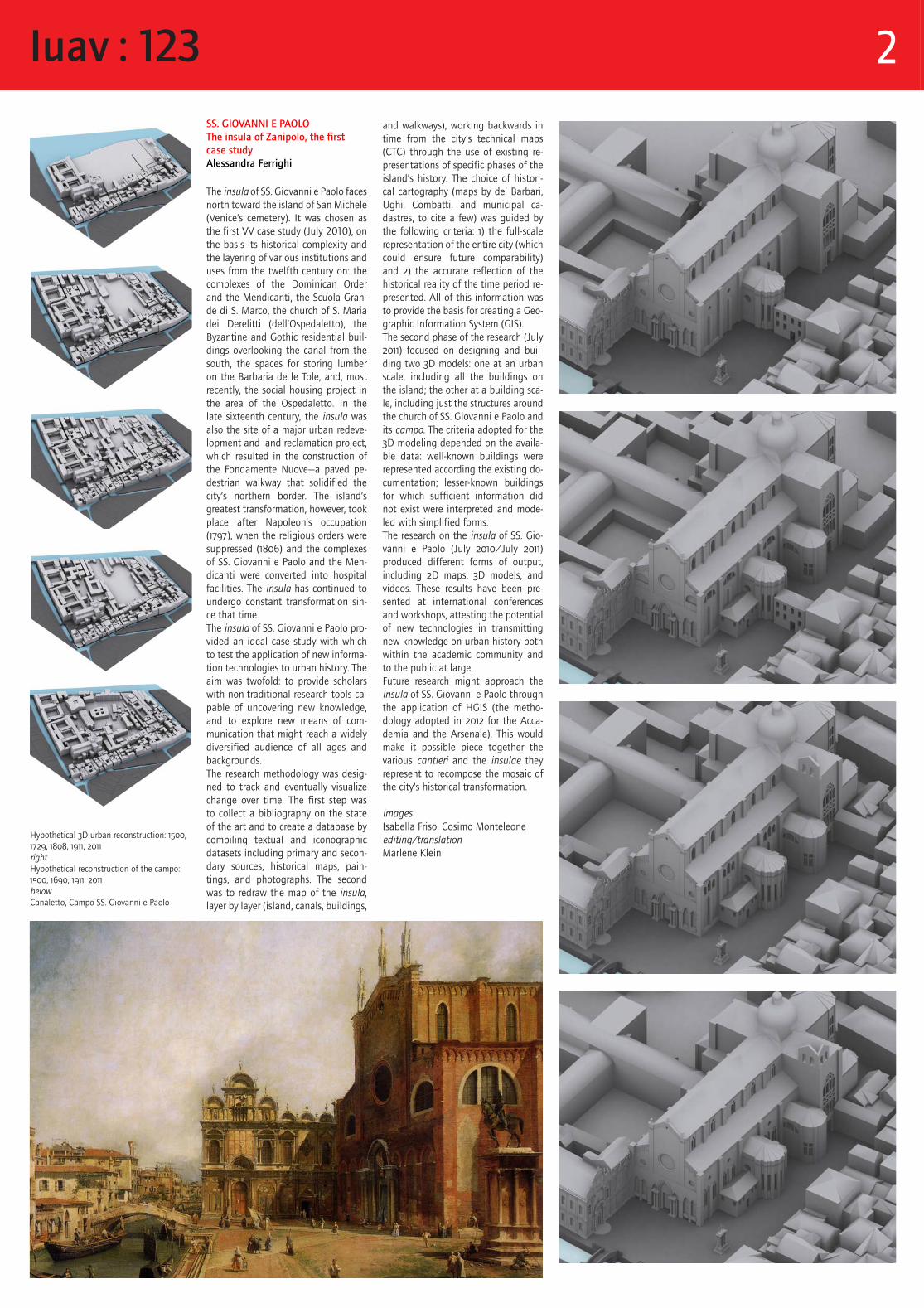
SS. GIOVANNI E PAOLOThe insula of Zanipolo, the first case studyAlessandra Ferrighi
The insula of SS. Giovanni e Paolo faces north toward the island of San Michele (Venice’s cemetery). It was chosen as the first VV case study (July 2010), on the basis its historical complexity and the layering of various institutions and uses from the twelfth century on: the complexes of the Dominican Order and the Mendicanti, the Scuola Gran-de di S. Marco, the church of S. Maria dei Derelitti (dell’Ospedaletto), the Byzantine and Gothic residential buil-dings overlooking the canal from the south, the spaces for storing lumber on the Barbaria de le Tole, and, most recently, the social housing project in the area of the Ospedaletto. In the late sixteenth century, the insula was also the site of a major urban redeve-lopment and land reclamation project, which resulted in the construction of the Fondamente Nuove—a paved pe-destrian walkway that solidified the city’s northern border. The island’s greatest transformation, however, took place after Napoleon’s occupation (1797), when the religious orders were suppressed (1806) and the complexes of SS. Giovanni e Paolo and the Men-dicanti were converted into hospital facilities. The insula has continued to undergo constant transformation sin-ce that time.The insula of SS. Giovanni e Paolo pro-vided an ideal case study with which to test the application of new informa-tion technologies to urban history. The aim was twofold: to provide scholars with non-traditional research tools ca-pable of uncovering new knowledge, and to explore new means of com-munication that might reach a widely diversified audience of all ages and backgrounds.The research methodology was desig-ned to track and eventually visualize change over time. The first step was to collect a bibliography on the state of the art and to create a database by compiling textual and iconographic datasets including primary and secon-dary sources, historical maps, pain-tings, and photographs. The second was to redraw the map of the insula, layer by layer (island, canals, buildings,
and walkways), working backwards in time from the city’s technical maps (CTC) through the use of existing re-presentations of specific phases of the island’s history. The choice of histori-cal cartography (maps by de’ Barbari, Ughi, Combatti, and municipal ca-dastres, to cite a few) was guided by the following criteria: 1) the full-scale representation of the entire city (which could ensure future comparability) and 2) the accurate reflection of the historical reality of the time period re-presented. All of this information was to provide the basis for creating a Geo-graphic Information System (GIS). The second phase of the research (July 2011) focused on designing and buil-ding two 3D models: one at an urban scale, including all the buildings on the island; the other at a building sca-le, including just the structures around the church of SS. Giovanni e Paolo and its campo. The criteria adopted for the 3D modeling depended on the availa-ble data: well-known buildings were represented according the existing do-cumentation; lesser-known buildings for which sufficient information did not exist were interpreted and mode-led with simplified forms.The research on the insula of SS. Gio-vanni e Paolo (July 2010/July 2011) produced different forms of output, including 2D maps, 3D models, and videos. These results have been pre-sented at international conferences and workshops, attesting the potential of new technologies in transmitting new knowledge on urban history both within the academic community and to the public at large.Future research might approach the insula of SS. Giovanni e Paolo through the application of HGIS (the metho-dology adopted in 2012 for the Acca-demia and the Arsenale). This would make it possible piece together the various cantieri and the insulae they represent to recompose the mosaic of the city’s historical transformation.
images Isabella Friso, Cosimo Monteleone editing/translationMarlene Klein
Hypothetical 3D urban reconstruction: 1500, 1729, 1808, 1911, 2011rightHypothetical reconstruction of the campo: 1500, 1690, 1911, 2011belowCanaletto, Campo SS. Giovanni e Paolo
Iuav : 123 2
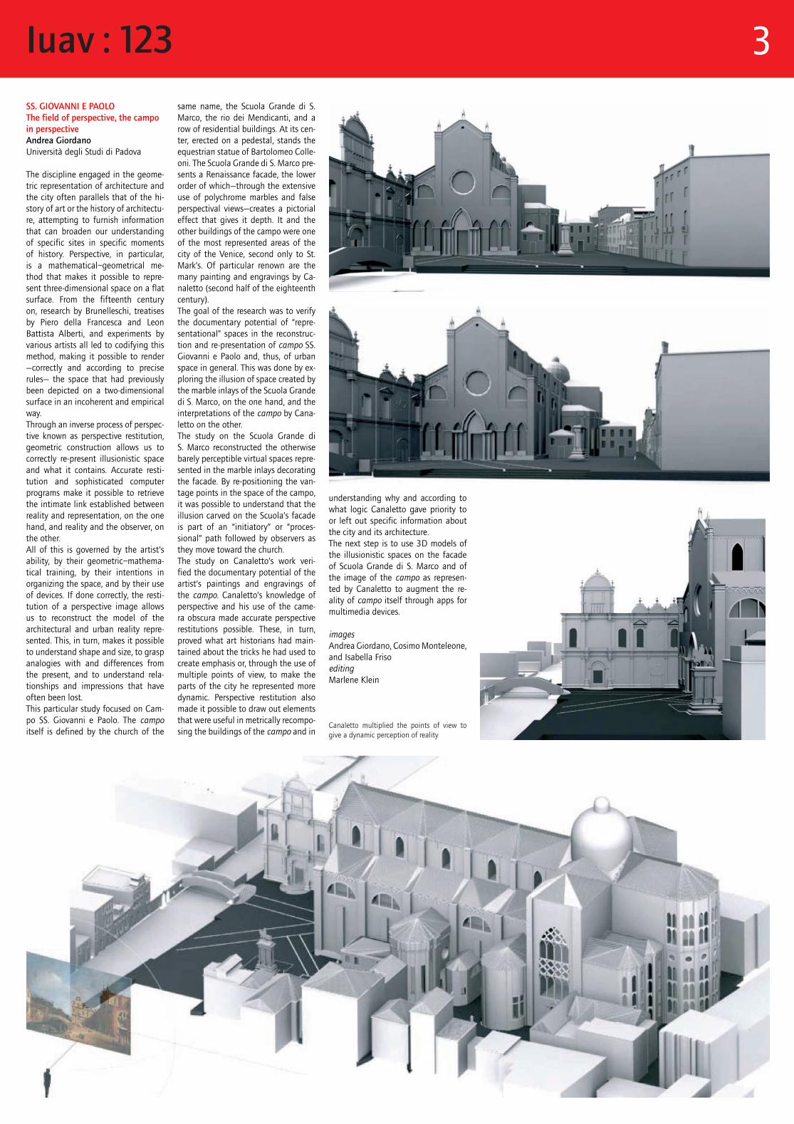
SS. GIOVANNI E PAOLOThe field of perspective, the campo in perspectiveAndrea GiordanoUniversità degli Studi di Padova
The discipline engaged in the geome-tric representation of architecture and the city often parallels that of the hi-story of art or the history of architectu-re, attempting to furnish information that can broaden our understanding of specific sites in specific moments of history. Perspective, in particular, is a mathematical–geometrical me-thod that makes it possible to repre-sent three-dimensional space on a flat surface. From the fifteenth century on, research by Brunelleschi, treatises by Piero della Francesca and Leon Battista Alberti, and experiments by various artists all led to codifying this method, making it possible to render —correctly and according to precise rules— the space that had previously been depicted on a two-dimensional surface in an incoherent and empirical way. Through an inverse process of perspec-tive known as perspective restitution, geometric construction allows us to correctly re-present illusionistic space and what it contains. Accurate resti-tution and sophisticated computer programs make it possible to retrieve the intimate link established between reality and representation, on the one hand, and reality and the observer, on the other. All of this is governed by the artist’s ability, by their geometric–mathema-tical training, by their intentions in organizing the space, and by their use of devices. If done correctly, the resti-tution of a perspective image allows us to reconstruct the model of the architectural and urban reality repre-sented. This, in turn, makes it possible to understand shape and size, to grasp analogies with and differences from the present, and to understand rela-tionships and impressions that have often been lost.This particular study focused on Cam-po SS. Giovanni e Paolo. The campo itself is defined by the church of the
same name, the Scuola Grande di S. Marco, the rio dei Mendicanti, and a row of residential buildings. At its cen-ter, erected on a pedestal, stands the equestrian statue of Bartolomeo Colle-oni. The Scuola Grande di S. Marco pre-sents a Renaissance facade, the lower order of which—through the extensive use of polychrome marbles and false perspectival views—creates a pictorial effect that gives it depth. It and the other buildings of the campo were one of the most represented areas of the city of the Venice, second only to St. Mark’s. Of particular renown are the many painting and engravings by Ca-naletto (second half of the eighteenth century).The goal of the research was to verify the documentary potential of “repre-sentational” spaces in the reconstruc-tion and re-presentation of campo SS. Giovanni e Paolo and, thus, of urban space in general. This was done by ex-ploring the illusion of space created by the marble inlays of the Scuola Grande di S. Marco, on the one hand, and the interpretations of the campo by Cana-letto on the other.The study on the Scuola Grande di S. Marco reconstructed the otherwise barely perceptible virtual spaces repre-sented in the marble inlays decorating the facade. By re-positioning the van-tage points in the space of the campo, it was possible to understand that the illusion carved on the Scuola’s facade is part of an “initiatory” or “proces-sional” path followed by observers as they move toward the church. The study on Canaletto’s work veri-fied the documentary potential of the artist’s paintings and engravings of the campo. Canaletto’s knowledge of perspective and his use of the came-ra obscura made accurate perspective restitutions possible. These, in turn, proved what art historians had main-tained about the tricks he had used to create emphasis or, through the use of multiple points of view, to make the parts of the city he represented more dynamic. Perspective restitution also made it possible to draw out elements that were useful in metrically recompo-sing the buildings of the campo and in
Canaletto multiplied the points of view to give a dynamic perception of reality
understanding why and according to what logic Canaletto gave priority to or left out specific information about the city and its architecture.The next step is to use 3D models of the illusionistic spaces on the facade of Scuola Grande di S. Marco and of the image of the campo as represen-ted by Canaletto to augment the re-ality of campo itself through apps for multimedia devices.
imagesAndrea Giordano, Cosimo Monteleone, and Isabella Frisoediting Marlene Klein
Iuav : 123 3
OSPEDALEThe Civic Hospital in Venice, built and unbuilt in time Gianmario GuidarelliUniversità degli Studi di PadovaInes TolicUniversità di Bologna
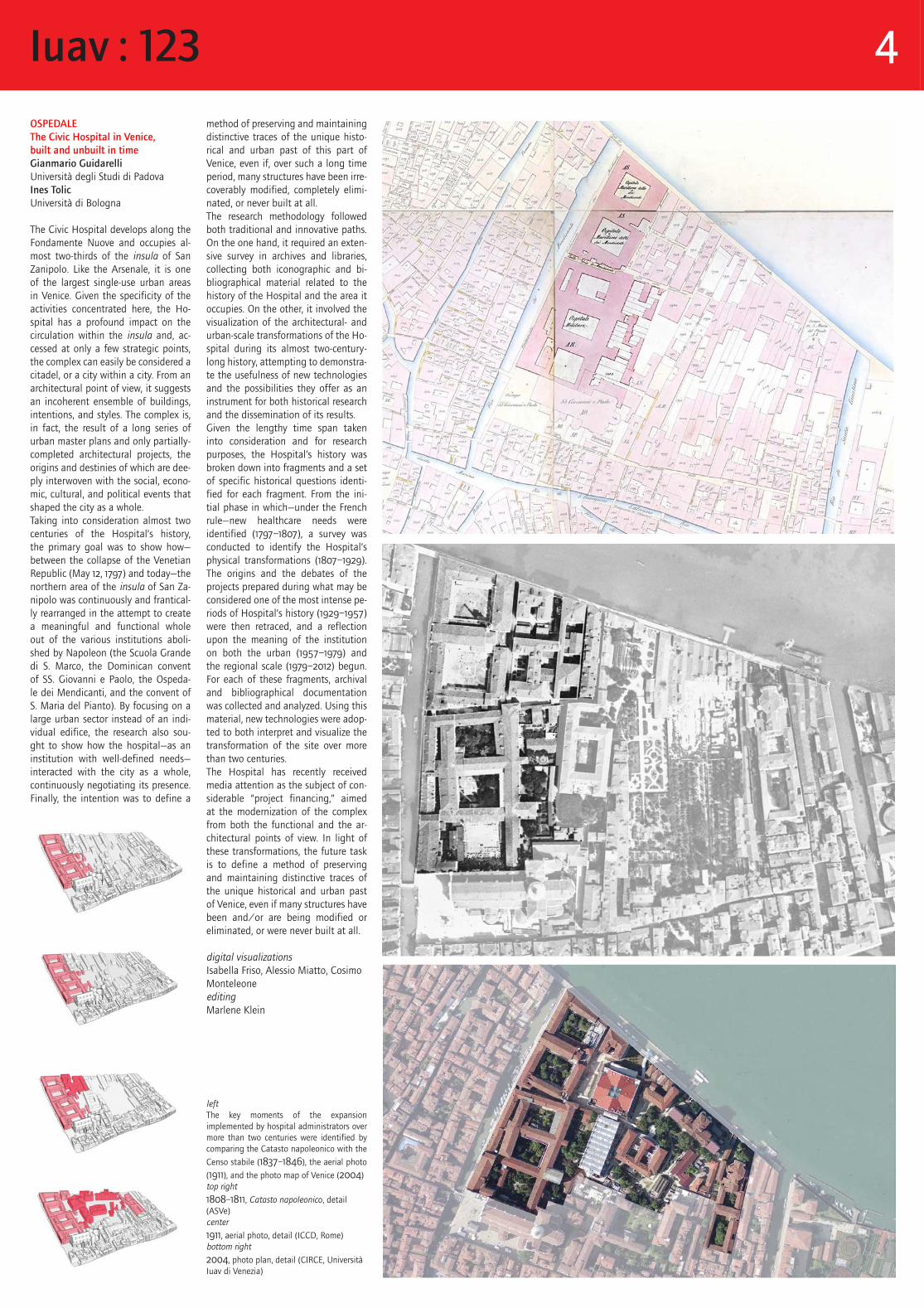
The Civic Hospital develops along the Fondamente Nuove and occupies al-most two-thirds of the insula of San Zanipolo. Like the Arsenale, it is one of the largest single-use urban areas in Venice. Given the specificity of the activities concentrated here, the Ho-spital has a profound impact on the circulation within the insula and, ac-cessed at only a few strategic points, the complex can easily be considered a citadel, or a city within a city. From an architectural point of view, it suggests an incoherent ensemble of buildings, intentions, and styles. The complex is, in fact, the result of a long series of urban master plans and only partially-completed architectural projects, the origins and destinies of which are dee-ply interwoven with the social, econo-mic, cultural, and political events that shaped the city as a whole.Taking into consideration almost two centuries of the Hospital’s history, the primary goal was to show how—between the collapse of the Venetian Republic (May 12, 1797) and today—the northern area of the insula of San Za-nipolo was continuously and frantical-ly rearranged in the attempt to create a meaningful and functional whole out of the various institutions aboli-shed by Napoleon (the Scuola Grande di S. Marco, the Dominican convent of SS. Giovanni e Paolo, the Ospeda-le dei Mendicanti, and the convent of S. Maria del Pianto). By focusing on a large urban sector instead of an indi-vidual edifice, the research also sou-ght to show how the hospital—as an institution with well-defined needs—interacted with the city as a whole, continuously negotiating its presence. Finally, the intention was to define a
method of preserving and maintaining distinctive traces of the unique histo-rical and urban past of this part of Venice, even if, over such a long time period, many structures have been irre-coverably modified, completely elimi-nated, or never built at all.The research methodology followed both traditional and innovative paths. On the one hand, it required an exten-sive survey in archives and libraries, collecting both iconographic and bi-bliographical material related to the history of the Hospital and the area it occupies. On the other, it involved the visualization of the architectural- and urban-scale transformations of the Ho-spital during its almost two-century-long history, attempting to demonstra-te the usefulness of new technologies and the possibilities they offer as an instrument for both historical research and the dissemination of its results.Given the lengthy time span taken into consideration and for research purposes, the Hospital’s history was broken down into fragments and a set of specific historical questions identi-fied for each fragment. From the ini-tial phase in which—under the French rule—new healthcare needs were identified (1797–1807), a survey was conducted to identify the Hospital’s physical transformations (1807–1929). The origins and the debates of the projects prepared during what may be considered one of the most intense pe-riods of Hospital’s history (1929–1957) were then retraced, and a reflection upon the meaning of the institution on both the urban (1957–1979) and the regional scale (1979–2012) begun. For each of these fragments, archival and bibliographical documentation was collected and analyzed. Using this material, new technologies were adop-ted to both interpret and visualize the transformation of the site over more than two centuries.The Hospital has recently received media attention as the subject of con-siderable “project financing,” aimed at the modernization of the complex from both the functional and the ar-chitectural points of view. In light of these transformations, the future task is to define a method of preserving and maintaining distinctive traces of the unique historical and urban past of Venice, even if many structures have been and/or are being modified or eliminated, or were never built at all.
digital visualizationsIsabella Friso, Alessio Miatto, Cosimo MonteleoneeditingMarlene Klein
leftThe key moments of the expansion implemented by hospital administrators over more than two centuries were identified by comparing the Catasto napoleonico with the
Censo stabile (1837–1846), the aerial photo
(1911), and the photo map of Venice (2004)top right
1808–1811, Catasto napoleonico, detail (ASVe)center
1911, aerial photo, detail (ICCD, Rome) bottom right
2004, photo plan, detail (CIRCE, UniversitàIuav di Venezia)
Iuav : 123 4
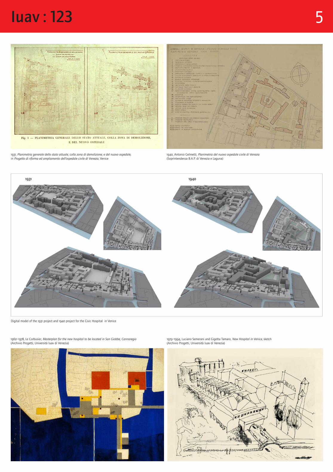
1931, Planimetria generale dello stato attuale, colla zona di demolizione, e del nuovo ospedale, in Progetto di riforma ed ampliamento dell’ospedale civile di Venezia, Venice
1940, Antonio Gelmetti, Planimetria del nuovo ospedale civile di Venezia (Soprintendenza B.A.P. di Venezia e Laguna)
1962–1978, Le Corbusier, Masterplan for the new hospital to be located in San Giobbe, Cannaregio (Archivio Progetti, Università Iuav di Venezia)
1979–1994, Luciano Semerani and Gigetta Tamaro, New Hospital in Venice, sketch (Archivio Progetti, Università Iuav di Venezia)
Digital model of the 1931 project and 1940 project for the Civic Hospital in Venice
1931 1940
Iuav : 123 5
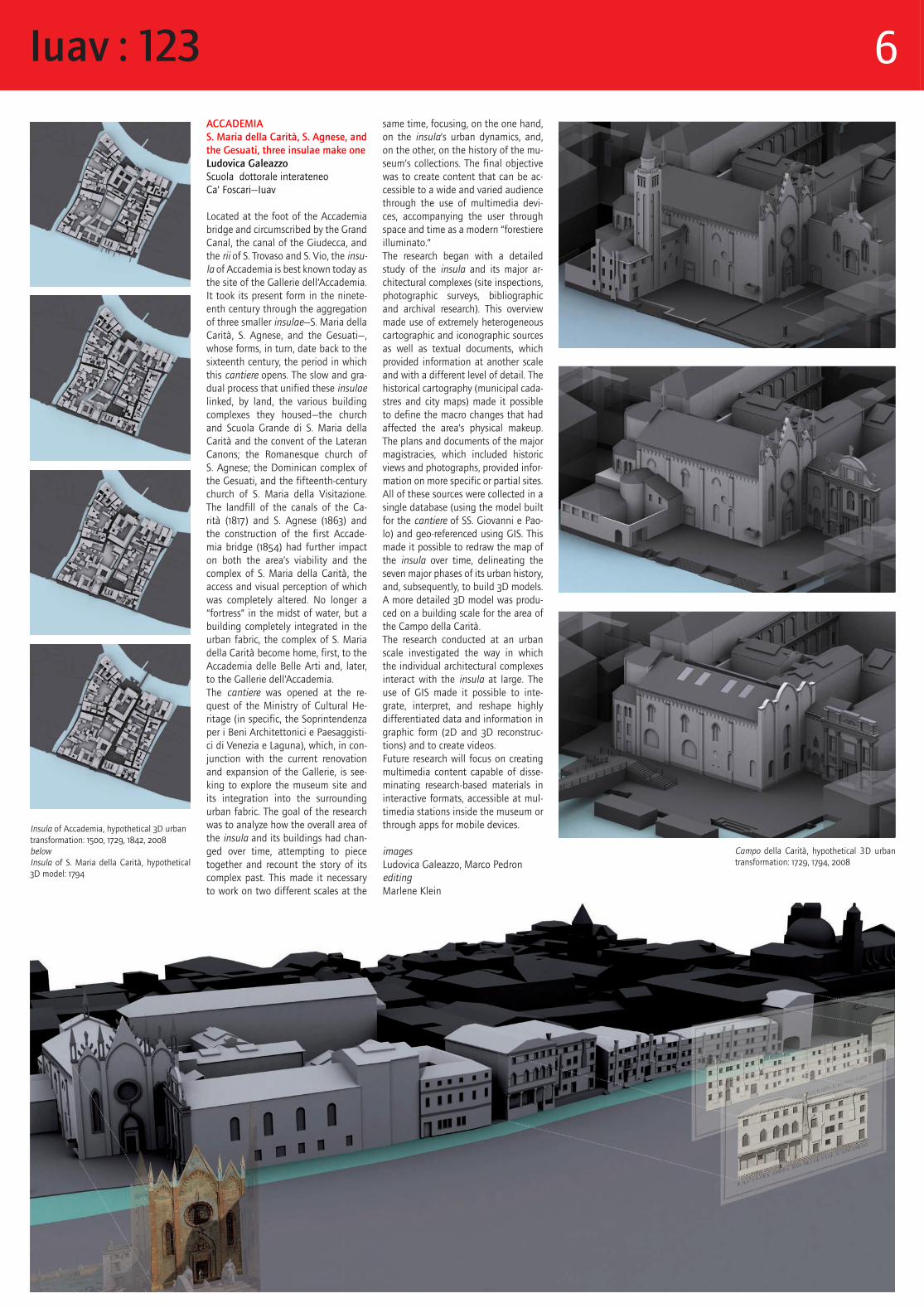
ACCADEMIAS. Maria della Carità, S. Agnese, and the Gesuati, three insulae make oneLudovica GaleazzoScuola dottorale interateneo Ca’ Foscari—Iuav
Located at the foot of the Accademia bridge and circumscribed by the Grand Canal, the canal of the Giudecca, and the rii of S. Trovaso and S. Vio, the insu-la of Accademia is best known today as the site of the Gallerie dell’Accademia. It took its present form in the ninete-enth century through the aggregation of three smaller insulae—S. Maria della Carità, S. Agnese, and the Gesuati—, whose forms, in turn, date back to the sixteenth century, the period in which this cantiere opens. The slow and gra-dual process that unified these insulae linked, by land, the various building complexes they housed—the church and Scuola Grande di S. Maria della Carità and the convent of the Lateran Canons; the Romanesque church of S. Agnese; the Dominican complex of the Gesuati, and the fifteenth-century church of S. Maria della Visitazione. The landfill of the canals of the Ca-rità (1817) and S. Agnese (1863) and the construction of the first Accade-mia bridge (1854) had further impact on both the area’s viability and the complex of S. Maria della Carità, the access and visual perception of which was completely altered. No longer a “fortress” in the midst of water, but a building completely integrated in the urban fabric, the complex of S. Maria della Carità become home, first, to the Accademia delle Belle Arti and, later, to the Gallerie dell’Accademia. The cantiere was opened at the re-quest of the Ministry of Cultural He-ritage (in specific, the Soprintendenza per i Beni Architettonici e Paesaggisti-ci di Venezia e Laguna), which, in con-junction with the current renovation and expansion of the Gallerie, is see-king to explore the museum site and its integration into the surrounding urban fabric. The goal of the research was to analyze how the overall area of the insula and its buildings had chan-ged over time, attempting to piece together and recount the story of its complex past. This made it necessary to work on two different scales at the
same time, focusing, on the one hand, on the insula’s urban dynamics, and, on the other, on the history of the mu-seum’s collections. The final objective was to create content that can be ac-cessible to a wide and varied audience through the use of multimedia devi-ces, accompanying the user through space and time as a modern “forestiere illuminato.”The research began with a detailed study of the insula and its major ar-chitectural complexes (site inspections, photographic surveys, bibliographic and archival research). This overview made use of extremely heterogeneous cartographic and iconographic sources as well as textual documents, which provided information at another scale and with a different level of detail. The historical cartography (municipal cada-stres and city maps) made it possible to define the macro changes that had affected the area’s physical makeup. The plans and documents of the major magistracies, which included historic views and photographs, provided infor-mation on more specific or partial sites. All of these sources were collected in a single database (using the model built for the cantiere of SS. Giovanni e Pao-lo) and geo-referenced using GIS. This made it possible to redraw the map of the insula over time, delineating the seven major phases of its urban history, and, subsequently, to build 3D models. A more detailed 3D model was produ-ced on a building scale for the area of the Campo della Carità.The research conducted at an urban scale investigated the way in which the individual architectural complexes interact with the insula at large. The use of GIS made it possible to inte-grate, interpret, and reshape highly differentiated data and information in graphic form (2D and 3D reconstruc-tions) and to create videos.Future research will focus on creating multimedia content capable of disse-minating research-based materials in interactive formats, accessible at mul-timedia stations inside the museum or through apps for mobile devices.
images Ludovica Galeazzo, Marco PedroneditingMarlene Klein
Insula of Accademia, hypothetical 3D urban transformation: 1500, 1729, 1842, 2008belowInsula of S. Maria della Carità, hypothetical 3D model: 1794
Campo della Carità, hypothetical 3D urban transformation: 1729, 1794, 2008
Iuav : 123 6
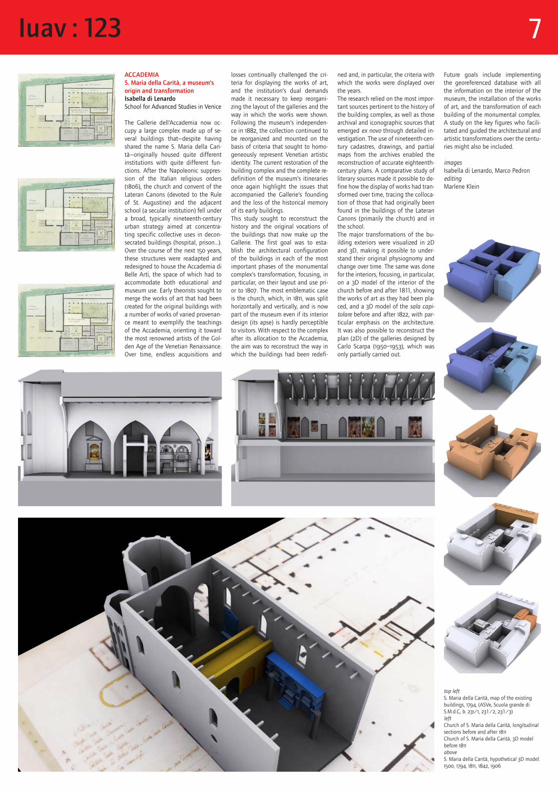
ned and, in particular, the criteria with which the works were displayed over the years. The research relied on the most impor-tant sources pertinent to the history of the building complex, as well as those archival and iconographic sources that emerged ex novo through detailed in-vestigation. The use of nineteenth-cen-tury cadastres, drawings, and partial maps from the archives enabled the reconstruction of accurate eighteenth-century plans. A comparative study of literary sources made it possible to de-fine how the display of works had tran-sformed over time, tracing the colloca-tion of those that had originally been found in the buildings of the Lateran Canons (primarily the church) and in the school.The major transformations of the bu-ilding exteriors were visualized in 2D and 3D, making it possible to under-stand their original physiognomy and change over time. The same was done for the interiors, focusing, in particular, on a 3D model of the interior of the church before and after 1811, showing the works of art as they had been pla-ced, and a 3D model of the sala capi-tolare before and after 1822, with par-ticular emphasis on the architecture. It was also possible to reconstruct the plan (2D) of the galleries designed by Carlo Scarpa (1950–1953), which was only partially carried out.
ACCADEMIAS. Maria della Carità, a museum’s origin and transformation Isabella di LenardoSchool for Advanced Studies in Venice
The Gallerie dell’Accademia now oc-cupy a large complex made up of se-veral buildings that—despite having shared the name S. Maria della Cari-tà—originally housed quite different institutions with quite different fun-ctions. After the Napoleonic suppres-sion of the Italian religious orders (1806), the church and convent of the Lateran Canons (devoted to the Rule of St. Augustine) and the adjacent school (a secular institution) fell under a broad, typically nineteenth-century urban strategy aimed at concentra-ting specific collective uses in decon-secrated buildings (hospital, prison…). Over the course of the next 150 years, these structures were readapted and redesigned to house the Accademia di Belle Arti, the space of which had to accommodate both educational and museum use. Early theorists sought to merge the works of art that had been created for the original buildings with a number of works of varied provenan-ce meant to exemplify the teachings of the Accademia, orienting it toward the most renowned artists of the Gol-den Age of the Venetian Renaissance. Over time, endless acquisitions and
losses continually challenged the cri-teria for displaying the works of art, and the institution’s dual demands made it necessary to keep reorgani-zing the layout of the galleries and the way in which the works were shown. Following the museum’s independen-ce in 1882, the collection continued to be reorganized and mounted on the basis of criteria that sought to homo-geneously represent Venetian artistic identity. The current restoration of the building complex and the complete re-definition of the museum’s itineraries once again highlight the issues that accompanied the Gallerie’s founding and the loss of the historical memory of its early buildings.This study sought to reconstruct the history and the original vocations of the buildings that now make up the Gallerie. The first goal was to esta-blish the architectural configuration of the buildings in each of the most important phases of the monumental complex’s transformation, focusing, in particular, on their layout and use pri-or to 1807. The most emblematic case is the church, which, in 1811, was split horizontally and vertically, and is now part of the museum even if its interior design (its apse) is hardly perceptible to visitors. With respect to the complex after its allocation to the Accademia, the aim was to reconstruct the way in which the buildings had been redefi-
top left S. Maria della Carità, map of the existing buildings, 1794, (ASVe, Scuola grande di S.M.d.C, b. 231/1, 231/2, 231/3) leftChurch of S. Maria della Carità, longitudinal sections before and after 1811Church of S. Maria della Carità, 3D model before 1811aboveS. Maria della Carità, hypothetical 3D model: 1500, 1794, 1811, 1842, 1906
Future goals include implementing the georeferenced database with all the information on the interior of the museum, the installation of the works of art, and the transformation of each building of the monumental complex. A study on the key figures who facili-tated and guided the architectural and artistic transformations over the centu-ries might also be included.
images Isabella di Lenardo, Marco PedroneditingMarlene Klein
Iuav : 123 7
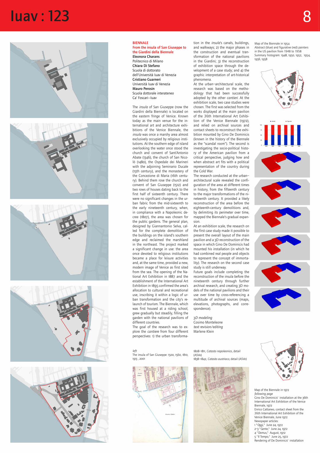
BIENNALEFrom the insula of San Giuseppe to the Giardini della BiennaleEleonora CharansPolitecnico di MilanoChiara Di StefanoScuola di dottoratodell’Università Iuav di VeneziaCristiano Guarneri Università Iuav di VeneziaMauro PerosinScuola dottorale interateneo Ca’ Foscari—Iuav
The insula of San Giuseppe (now the Giardini della Biennale) is located on the eastern fringe of Venice. Known today as the main venue for the in-ternational art and architecture exhi-bitions of the Venice Biennale, the insula was once a marshy area almost exclusively occupied by religious insti-tutions. At the southern edge of island overlooking the water once stood the church and convent of Sant’Antonio Abate (1346), the church of San Nico-lò (1480), the Ospedale dei Marineri with the adjoining Seminario Ducale (15th century), and the monastery of the Concezione di Maria (16th centu-ry). Behind them rose the church and convent of San Giuseppe (1512) and two rows of houses dating back to the first half of sixteenth century. There were no significant changes in the ur-ban fabric from the mid-sixteenth to the early nineteenth century, when, in compliance with a Napoleonic de-cree (1807), the area was chosen for the public gardens. The general plan, designed by Giannantonio Selva, cal-led for the complete demolition of the buildings on the island’s southern edge and reclaimed the marshland in the northeast. The project marked a significant change in use: the area once devoted to religious institutions became a place for leisure activities and, at the same time, provided a new, modern image of Venice as first sited from the sea. The opening of the Na-tional Art Exhibition in 1887 and the establishment of the International Art Exhibition in 1895 confirmed the area’s allocation to cultural and recreational use, inscribing it within a logic of ur-ban transformation and the city’s re-launch of tourism. The Biennale, which was first housed at a riding school, grew gradually but steadily, filling the garden with the national pavilions of different countries.The goal of the research was to ex-plore the cantiere from four different perspectives: 1) the urban transforma-
tion in the insula’s canals, buildings, and walkways; 2) the major phases in the construction and eventual tran-sformation of the national pavilions in the Giardini; 3) the reconstruction of exhibition space through the de-velopment of a case study; and 4) the graphic interpretation of art-historical phenomena.At the urban–architectural scale, the research was based on the metho-dology that had been successfully adopted by the other cantieri. At the exhibition scale, two case studies were chosen. The first was selected from the works displayed at the main pavilion of the 36th International Art Exhibi-tion of the Venice Biennale (1972), and relied on archival sources and contact sheets to reconstruct the exhi-bition mounted by Gino De Dominicis (known in the history of the Biennale as the “scandal room”). The second is investigating the socio-political histo-ry of the American pavilion from a critical perspective, judging how and when abstract art fits with a political representation of the country during the Cold War.The research conducted at the urban–architectural scale revealed the confi-guration of the area at different times in history, from the fifteenth century to the major transformations of the ni-neteenth century. It provided a likely reconstruction of the area before the eighteenth-century demolitions and, by delimiting its perimeter over time, mapped the Biennale’s gradual expan-sion.At an exhibition scale, the research on the first case study made it possible to present the overall layout of the main pavilion and a 3D reconstruction of the space in which Gino De Dominicis had mounted his installation (in which he had combined real people and objects to represent the concept of immorta-lity). The research on the second case study is still underway.Future goals include completing the reconstruction of the insula before the nineteenth century through further archival research, and creating 3D mo-dels of the national pavilions and their use over time by cross-referencing a multitude of archival sources (maps, elevations, photographs, and corre-spondence).
3D modeling Cosimo Monteleonetext revision/editingMarlene Klein
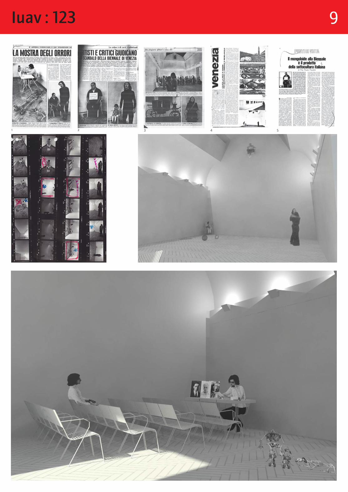
Map of the Biennale in 1972following pageGino De Dominicis' installation at the 36th International Art Exhibition of the Venice Biennale, 1972Enrico Cattaneo, contact sheet from the 36th International Art Exhibition of the Venice Biennale, June 1972Newspaper articles:1 "Oggi," June 24, 19722–3 "Gente," June 24, 19724 "Domus," August, 19725 "Il Tempo," June 25, 1972Rendering of De Dominicis' installation
leftThe insula of San Giuseppe: 1500, 1560, 1810, 1913 , 2001
Map of the Biennale in 1954Abstract (blue) and figurative (red) painters in the US pavilion from 1948 to 1958Summary histogram: 1948, 1950, 1952, 1954, 1956, 1958
1808–1811, Catasto napoleonico, detail (ASVe)1838–1842, Catasto austriaco, detail (ASVe)
Iuav : 123 8
1 2 3 4 5
Iuav : 123 9
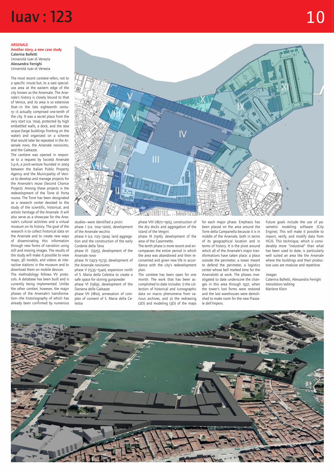
ARSENALEAnother story, a new case studyCaterina BallettiUniversità Iuav di VeneziaAlessandra FerrighiUniversità Iuav di Venezia
The most recent cantiere refers, not to a specific insula but, to a vast special-use area at the eastern edge of the city known as the Arsensale. The Arse-nale’s history is closely bound to that of Venice, and its area is so extensive that—in the late eighteenth centu-ry—it actually comprised one-tenth of the city. It was a secret place from the very start (ca. 1104), protected by high embattled walls, a dock, and the tese acque (large buildings fronting on the water) and organized on a scheme that would later be repeated in the Ar-senale novo, the Arsenale novissimo, and the Galeazze.The cantiere was opened in respon-se to a request by Società Arsenale S.p.A, a joint-venture founded in 2003 between the Italian Public Property Agency and the Municipality of Veni-ce to develop and manage projects for the Arsenale’s reuse (Second Chance Project). Among these projects is the redevelopment of the Torre di Porta nuova. The Torre has been designated as a research center devoted to the study of the scientific, historical, and artistic heritage of the Arsenale. It will also serve as a showcase for the Arse-nale’s cultural activities and a virtual museum on its history. The goal of the research is to collect historical data on the Arsenale and to create new ways of disseminating this information through new forms of narration using still and moving images. The results of the study will make it possible to view maps, 3D models, and videos at inte-ractive stations in the museum and to download them on mobile devices.The methodology follows VV proto-cols. A database has been built and is currently being implemented. Unlike the other cantieri, however, the major phases of the Arsenale’s transforma-tion—the historiography of which has already been confirmed by numerous
studies—were identified a priori: phase I (ca. 1104–1200), development of the Arsenale vecchiophase II (ca. 1125–1304), land aggrega-tion and the construction of the early Corderie della Tanaphase III (1325), development of the Arsenale novophase IV (1473–1573), development of the Arsenale novissimophase V (1535–1540), expansion north of S. Maria della Celestia to create a safe space for storing gunpowderphase VI (1569), development of the Darsena delle Galeazzephase VII (1810), annexation of com-plex of convent of S. Maria della Ce-lestia
phase VIII (1872–1915), construction of the dry docks and aggregation of the island of the Verginiphase IX (1916), development of the area of the Casermette.The tenth phase is more recent and en-compasses the entire period in which the area was abandoned and then re-converted and given new life in accor-dance with the city’s redevelopment plan.The cantiere has been open for one month. The work that has been ac-complished to date includes: 1) the col-lection of historical and iconographic data on macro phenomena from va-rious archives, and 2) the redrawing (2D) and modeling (3D) of the maps
for each major phase. Emphasis has been placed on the area around the Torre della Campanella because it is in middle of the Arsenale, both in terms of its geographical location and in terms of history. It is the pivot around which all of the Arsenale’s major tran-sformations have taken place: a place outside the perimeter, a tower meant to defend the perimeter, a logistics center whose bell marked time for the Arsenalotti at work. The phases inve-stigated to date underscore the chan-ges in this area through 1937, when the tower’s lost forms were restored and the last warehouses were demoli-shed to make room for the new Piazza-le dell’Impero.
Future goals include the use of pa-rametric modeling software (City Engine). This will make it possible to import, verify, and modify data from HGIS. This technique, which is consi-derably more “industrial” than what has been used to date, is particularly well suited an area like the Arsenale where the buildings and their produc-tive uses are modular and repetitive.
imagesCaterina Balletti, Alessandra Ferrighi translation/editingMarlene Klein
Iuav : 123 10
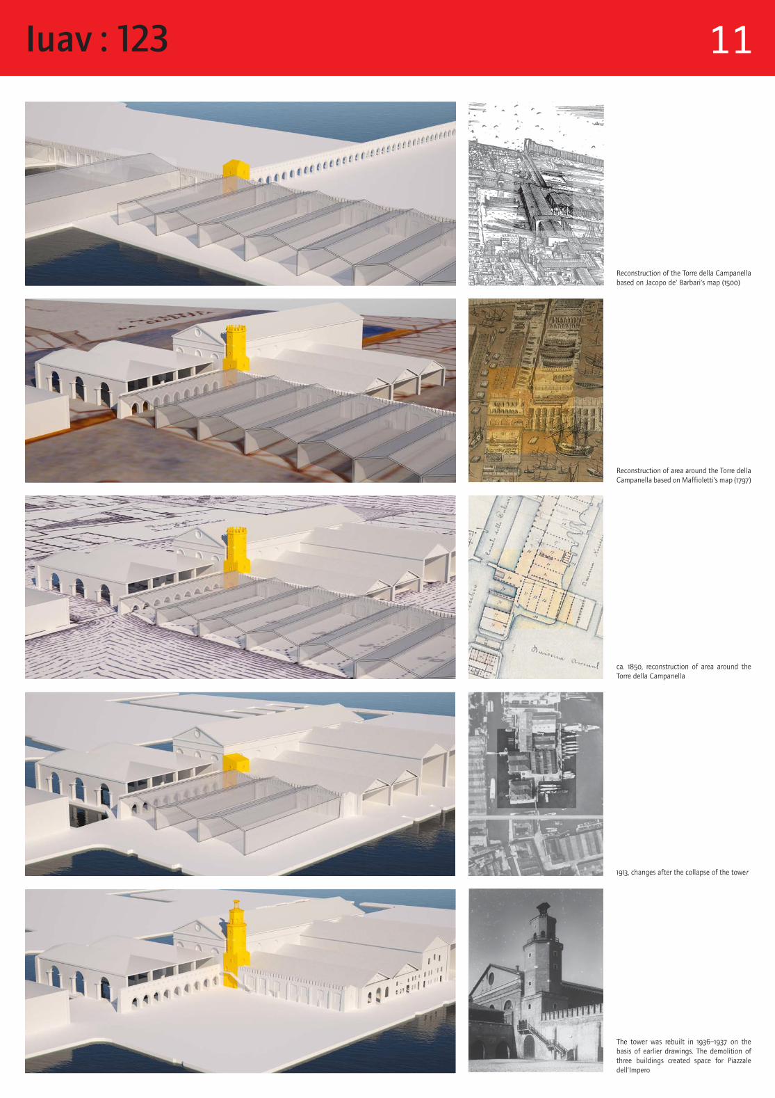
Reconstruction of the Torre della Campanella based on Jacopo de’ Barbari’s map (1500)
Reconstruction of area around the Torre della Campanella based on Maffioletti’s map (1797)
ca. 1850, reconstruction of area around the Torre della Campanella
1913, changes after the collapse of the tower
The tower was rebuilt in 1936–1937 on the basis of earlier drawings. The demolition of three buildings created space for Piazzale dell’Impero
Iuav : 123 11
Exhibition promoted byUniversità Iuav di VeneziaUnità di ricerca “Memoria e Rappresentazione”
curatorAlessandra Ferrighi, Adjunct Professor Università Iuav di Venezia
steering committeeDonatella Calabi, Full ProfessorUniversità Iuav di VeneziaAndrea Giordano, Associate ProfessorUniversità degli Studi di Padova
research supervisor ArsenaleEnnio Concina, Full Professorteam coordinator BiennaleFrancesca Castellani, Associate ProfessorUniversità Iuav di Veneziateam coordinator AccademiaElena Svalduz, Assistant ProfessorUniversità degli Studi di Padova
researchGianmario Guidarelli, Adjunct ProfessorUniversità degli Studi di PadovaInes Tolic, Assistant Professor Università di BolognaEleonora Charans, Teaching AssistantPolitecnico di MilanoCristiano Guarneri, Research FellowUniversità Iuav di VeneziaIsabella di Lenardo, PhD candidateSchool for Advanced Studies in VeniceChiara Di Stefano, PhD candidateScuola dottorale Università Iuav di VeneziaLudovica Galeazzo, PhD candidateScuola dottorale interateneo Ca’ Foscari-IuavMauro Perosin, PhD candidateScuola dottorale interateneo Ca’ Foscari-Iuav
VV Research partnershipUniversità Iuav di VeneziaDuke UniversityUniversità degli Studi di PadovaNesting scrl
co-founders / directorsCaroline Bruzelius, Full Professor, Duke UniversityDonatella Calabi, Full Professor, Università Iuav di Venezia
steering committeeGuido Zucconi, Full Professor, Università Iuav di VeneziaAndrea Giordano, Associate Professor, Università degli Studi di PadovaMark Olson, Assistant Professor, Duke UniversityVictoria Szabo, Research Assistant Professor, Duke University
VV coordinator (Venice) 2010Gianmario Guidarelli, Adjunct Professor, Università degli Studi di PadovaVV coordinator (Venice) 2011—Alessandra Ferrighi, Adjunct Professor, Università Iuav di Venezia
researchSS. Giovanni e PaoloJoseph Chandler Williams, PhD candidate, Duke UniversityAlexandra Dodson, PhD candidate, Duke UniversityAlessandra Ferrighi, Adjunct Professor, Università Iuav di VeneziaGianmario Guidarelli, Adjunct Professor, Università degli Studi di PadovaErica Sherman, PhD candidate, Duke University
OspedaleGianmario Guidarelli, Adjunct Professor, Università degli Studi di PadovaInes Tolic, Assistant Professor, Università di Bologna
AccademiaJoseph Chandler Williams, PhD candidate, Duke UniversityIsabella di Lenardo, PhD candidate, School for Advanced Studies in VeniceIara Dundas, PhD candidate, Duke University
grateful acknowledgement to the following institutions for granting the free use of images and archival reproductions Archivio di Stato di Venezia, Archivio Enrico Cattaneo di Milano, Archivio progetti Iuav di Venezia, Archivio Storico del Comune di Venezia, Archivio storico, Archivio disegni, Archivio fotografico della Soprintendenza per i Beni Architettonici e Paesaggistici di Venezia e Laguna, Biblioteca del Museo Correr di Venezia, Biblioteca Nazionale Marciana di Venezia, CIRCE – Laboratorio di cartografia e GIS Iuav di Venezia, ICCD – Istituto centrale per il Catalogo e la Documentazione, Ministero per i Beni e le Attività Culturali Roma
special thanks toAlberto Bovo, Marina Cabianca, Giovanni Caniato, Claudio Carboni, Renata Codello, Pietro Coffaro, Francesco Contò, Ambra Dina, Ciro Iuliano, Sandro Manente, Massimo Mazzanti, Lino Melato, MicaelaPortinari, Raffaele Santoro, Luca Slongo, Raffaele Speranzon, Gianni Toniolo, Alberto Torsello, Michele Zanella
Ludovica Galeazzo, PhD candidate, Scuola dottorale interateneo Ca’ Foscari-IuavElisabeth Narkin, PhD candidateDuke UniversityElena Svalduz, Assistant ProfessorUniversità degli Studi di Padova
BiennaleEleonora Charans, Teaching Assistant, Politecnico di MilanoChiara Di Stefano, PhD candidateScuola dottorale Università Iuav di VeneziaCristiano Guarneri, Research FellowUniversità Iuav di VeneziaLaura Moure Cecchini, PhD candidateDuke UniversityMauro Perosin, PhD candidate, Scuola dottorale interateneo Ca’ Foscari-Iuav
ArsenaleCaterina Balletti, Adjunct ProfessorUniversità Iuav di VeneziaAlessandra Ferrighi, Adjunct ProfessorUniversità Iuav di Venezia
database and HGISAlessandra Ferrighi, Adjunct ProfessorUniversità Iuav di VeneziaMattia Grosso, Nesting Scrl
georeferencing and GISAlessandra Ferrighi, Adjunct Professor, Università Iuav di VeneziaLudovica Galeazzo, PhD candidate, Scuola dottorale interateneo Ca’ Foscari-IuavCristiano Guarneri, Research Fellow, Università Iuav di VeneziaNiccolò Iandelli, PhD candidate, Università Iuav di Venezia
digital modelingMatteo Ballarin, Adjunct ProfessorUniversità Iuav di VeneziaCaterina Balletti, Adjunct ProfessorUniversità Iuav di VeneziaIsabella Friso, PhD candidateUniversità Iuav di VeneziaAlessio Miatto, undergraduateUniversità degli Studi di PadovaCosimo Monteleone, PhD candidateUniversità Iuav di VeneziaMarco Pedron, undergraduateUniversità degli Studi di Padova
3D prototypingCosimo Monteleone, PhD candidateUniversità Iuav di VeneziaMarco Pedron, undergraduateUniversità degli Studi di Padova
digital mediaSarah Goetz, Duke UniversityMattia Grosso, Nesting ScrlErica Sherman, PhD candidateDuke University
editorial consultantMarlene Klein, Adjunct ProfessorUniversità Iuav di Venezia
sponsored byThe Gladys Krieble Delmas FoundationFondazione di VeneziaArsenale di VeneziaSecond ChanceEuropean Union, European Regional Development Fund Central Europe, Cooperating for Success
digital modelingCaterina Balletti, Adjunct ProfessorUniversità Iuav di VeneziaIsabella Friso, PhD candidateUniversità Iuav di VeneziaCosimo Monteleone, PhD candidateUniversità Iuav di VeneziaAlessio Miatto, undergraduateUniversità degli Studi di PadovaMarco Pedron, undergraduateUniversità degli Studi di Padova
digital mediaIsabella di Lenardo, PhD candidateSchool for Advanced Studies in VeniceErica Sherman, PhD candidateDuke UniversityMattia Grosso, Nesting Scrl
editorial consultantMarlene Klein, Adjunct ProfessorUniversità Iuav di Venezia
with the patronage ofProvincia di Venezia
sponsored byProvincia di Venezia, Assessorato alla Cultura, sport e tempo libero della Provincia di VeneziaUniversità Iuav di Venezia, Unità di ricerca “Memoria e Rappresentazione”Prosecco Desiderio Jeio, Bisol (Valdobbiadene, Treviso)Eliografia Quattroesse (Treviso)PMaroello srl (Udine)CMF Marelli (Milano)
communication project (logo)Hangar Design Group
Iuav : 123 12