Virtual Tour of Maine's Mines and · PDF fileThe photo above shows the remains of a quarry...
48
Maine Geological Survey Maine Mines and Quarries Virtual Tour of Maine’s Mines and Quarries Maine Geological Survey, Department of Agriculture, Conservation & Forestry 1
Transcript of Virtual Tour of Maine's Mines and · PDF fileThe photo above shows the remains of a quarry...

Maine Geological Survey Maine Mines and Quarries
Virtual Tour of
Maine’s Mines and Quarries
Maine Geological Survey, Department of Agriculture, Conservation & Forestry 1

Maine Geological Survey Maine Mines and Quarries
Introduction
Mining in Maine has a long history unknown to many citizens. Some of us have seen the granite quarries which remain from an industry established more than 150 years ago. Gravel pits are a common sight today, and many people are familiar with Maine’s limestone, slate, and crushed stone operations. However, the well-known resources of modern times are but a few of the mineral products that have been produced in Maine. Economic conditions, technological developments, and world events have influenced the level of mining activity in our state.
Contents Metals 3 Stone 20 Minerals 34 Surficial Materials 41
Maine Geological Survey, Department of Agriculture, Conservation & Forestry 2

Maine Geological Survey Maine Mines and Quarries
Lubec Lead Mine Diagram
Most metal mines in Maine are very small and have not been worked for a long time. One of the oldest is the Lubec Lead Mine, which was operated in the 1830's. In 1837 the first State Geologist, Charles T. Jackson, published this view of one of the ore veins and mine adits exposed in a cliff along the ocean shore.
Jack
son
, 18
37
Maine Geological Survey, Department of Agriculture, Conservation & Forestry 3

Maine Geological Survey Maine Mines and Quarries
Lubec Lead Mine
The old workings of the Lubec Lead Mine are still visible today and may be visited as a mineral collecting locality. Extreme caution is required to avoid being caught by rising tides in this area.
Maine Geological Survey
Maine Geological Survey, Department of Agriculture, Conservation & Forestry 4

Maine Geological Survey Maine Mines and Quarries
Katahdin Iron Works
In the mid 1840's, Katahdin Iron Works began operations to smelt bog iron. This view of the brick charcoal kilns was taken from atop the furnace. At the peak of operation, sixteen of these kilns rendered cords of wood down to the charcoal that fueled the furnace. The kiln closest to the camera (center) is the only one that still remains intact.
Maine Geological Survey
Maine Geological Survey, Department of Agriculture, Conservation & Forestry 5

Maine Geological Survey Maine Mines and Quarries
Katahdin Iron Works Historic Site
The remaining brick kiln at Katahdin Iron Works, now a state historic site. The blast furnace is seen at rear left of photo.
Maine Geological Survey Ph
oto
by
Joh
n B
. Po
isso
n
Maine Geological Survey, Department of Agriculture, Conservation & Forestry 6

Maine Geological Survey Maine Mines and Quarries
Blast Furnace
The remains of the blast furnace at Katahdin Iron Works.
Maine Geological Survey Ph
oto
by
Joh
n B
. Po
isso
n
Maine Geological Survey, Department of Agriculture, Conservation & Forestry 7

Maine Geological Survey Maine Mines and Quarries
Maine Mining Journal
The most notorious development in Maine's mining history was the metal mining boom of 1879 to 1882. The origin of this boom is unclear, though it is said that men returning from the gold rushes in the West found a similarity between the metal-bearing rocks of Maine and ore deposits of the western states. There was great excitement as mining companies were organized, buildings were erected, expensive machinery was installed, and in some cases mills, concentrators, and smelters were constructed. Much of the activity occurred around Blue Hill, Sullivan, Acton, and Lubec. It soon reached such a high level that a weekly industry newspaper, the "Maine Mining Journal," was published in Bangor beginning in 1880.
Maine Geological Survey
Maine Geological Survey, Department of Agriculture, Conservation & Forestry 8
Maine Geological Survey Maine Mines and Quarries
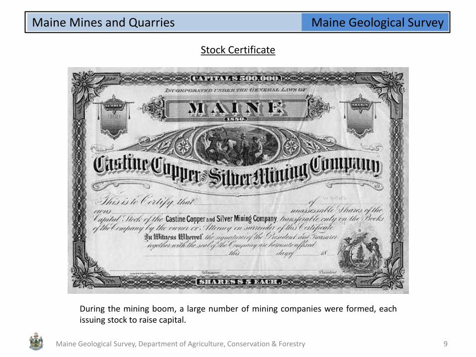
Stock Certificate
During the mining boom, a large number of mining companies were formed, each issuing stock to raise capital.
Maine Geological Survey
Maine Geological Survey, Department of Agriculture, Conservation & Forestry 9

Maine Geological Survey Maine Mines and Quarries
Douglass Mine Postcard
During the mining boom, one of the few mines to actually produce smelted metal was the Douglass Copper Mine, located in Blue Hill. This view (from a postcard) shows the construction of the milling and smelting works of the mine. The mine was operated from 1878 to 1883, and in 1918.
Maine Geological Survey
Maine Geological Survey, Department of Agriculture, Conservation & Forestry 10

Maine Geological Survey Maine Mines and Quarries
Douglass Mine
Although prospecting continued and several metal mines reopened for a short time, no major mining occurred in Maine during the remainder of the 1800's. There was a brief period of activity in Cherryfield around 1905-07, when the price of silver was favorable. The shipment of copper concentrates from the Douglass Mine in Blue Hill by American Smelting and Refining Co. in 1918 marked the last production of base metals from Maine mines until the late 1960's. The photo above shows the entrance to old underground workings at the Douglass Copper Mine in Blue Hill.
Maine Geological Survey
Maine Geological Survey, Department of Agriculture, Conservation & Forestry 11

Maine Geological Survey Maine Mines and Quarries
Manganese Ore
The average manganese content of the ore is about 9 percent. At that time, however, a process by which manganese could be extracted economically from the type of ore found in Aroostook County had not been developed. The sample above is of manganese ore from Hovey Mountain in Aroostook County.
During the war years of the 1940's, minerals on the War Department's "strategic list" were of utmost importance. In view of the urgent need for manganese to meet the demands of the steel industry, work began in the summer of 1941 to evaluate manganese deposits in Aroostook County that had been discovered over 100 years before. Altogether, the work during the war years indicated reserves of metallic manganese in Aroostook County of about 2,100,000 tons.
Maine Geological Survey
Maine Geological Survey, Department of Agriculture, Conservation & Forestry 12

Maine Geological Survey Maine Mines and Quarries
Callahan Mine 1970
In 1965 Callahan Mining Corporation of New York acquired the old Harborside Copper Mine in Brooksville. Originally opened in the 1880's, the Harborside Mine had been leased by Penobscot Mining Corporation in the mid 1950's. The latter company had staked claims on Goose Falls Pond and delineated a sulfide ore body. Callahan Mining obtained permission from the State to temporarily drain Goose Pond, which was a tidal inlet, in order to develop an open pit copper-zinc mine at the Harborside property. The photo above shows the open pit at the Callahan Mine, Brooksville, ca. 1970, when the mine was active.
Ph
oto
co
urt
esy
of
Fred
Bec
k
Maine Geological Survey, Department of Agriculture, Conservation & Forestry 13

Maine Geological Survey Maine Mines and Quarries
Callahan Mine Mill Complex
Callahan Mining Corporation built a flotation mill to extract copper and zinc concentrates from the ore, and began mining in 1968. The copper concentrates were shipped to the Noranda smelter in Gaspe, while the zinc concentrates went to a smelter in Pennsylvania. The photo above shows the Callahan Mine mill complex.
Maine Geological Survey
Maine Geological Survey, Department of Agriculture, Conservation & Forestry 14

Maine Geological Survey Maine Mines and Quarries
Callahan Mine Core
In 1972, after 5 years of production, Callahan Mining closed its copper-zinc mining and milling operation at Harborside in Brooksville due to depletion of reserves. During this time the Callahan Mine had yielded 800,000 tons of ore grading 5.5% zinc, 1.25% copper, 0.5% lead, and 0.5 oz/ton silver. The photo shows a giant rock core at the site of the Callahan Mine in Brooksville.
Maine Geological Survey Ph
oto
by
Wo
od
row
B. T
ho
mp
son
Maine Geological Survey, Department of Agriculture, Conservation & Forestry 15
Maine Geological Survey Maine Mines and Quarries
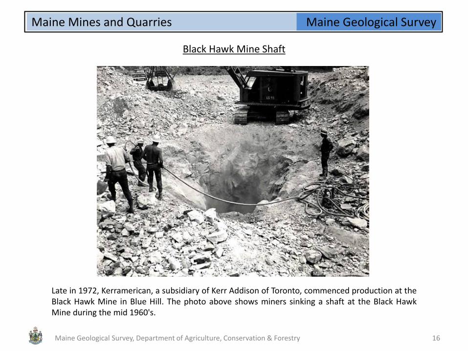
Black Hawk Mine Shaft
Late in 1972, Kerramerican, a subsidiary of Kerr Addison of Toronto, commenced production at the Black Hawk Mine in Blue Hill. The photo above shows miners sinking a shaft at the Black Hawk Mine during the mid 1960's.
Maine Geological Survey
Maine Geological Survey, Department of Agriculture, Conservation & Forestry 16

Maine Geological Survey Maine Mines and Quarries
Black Hawk Mill
Black Hawk (Kerr American) mill construction, next to Second Pond, Blue Hill. The ore was processed on site for zinc and copper concentrates, which were shipped out of state for smelting. Mining continued until the fall of 1977. Based on extrapolation of 1976 statistics, it is estimated that the total output of the Black Hawk Mine during this period was approximately 1,000,000 tons containing 7.35% zinc, 0.89% copper, and 0.35% lead.
Maine Geological Survey
Maine Geological Survey, Department of Agriculture, Conservation & Forestry 17

Maine Geological Survey Maine Mines and Quarries
Black Hawk Mine
Headframe of the Black Hawk Mine. After operations ceased, equipment was removed from the mine and the mine openings were sealed with concrete bulkheads. To reclaim the sulfide tailings, glacial till and topsoil were graded over the tailings and reseeded.
Maine Geological Survey
Maine Geological Survey, Department of Agriculture, Conservation & Forestry 18

Maine Geological Survey Maine Mines and Quarries
Bald Mountain Ore
In September, 1977, a 36 million-ton massive copper-zinc sulfide deposit was discovered at Bald Mountain in T12 R8, Aroostook County, Maine. It was estimated by some to be the third most significant copper discovery on the North American continent since the 1950's. The discovery of the Bald Mountain deposit was the culmination of years of exploration by Maine geologist John S. Cummings. Utilizing innovative geochemical techniques coupled with persistence, patience, and trial and error, Cummings pinpointed the deposit in an assemblage of volcanic rocks which extend for approximtely 130 miles in a belt 50-60 miles wide across north-central Maine. As of this date, the deposit has not been developed.
Maine Geological Survey
Maine Geological Survey, Department of Agriculture, Conservation & Forestry 19

Maine Geological Survey Maine Mines and Quarries
Stinchfield Quarry
Quarrying was concentrated around Penobscot Bay, eastern Washington County, Hallowell, Biddeford, and the Blue Hill area. The granite industry reached its high point in 1901, with 152 quarries employing at least 3,500 men. Maine ranked first in the country in terms of value of granite produced. The photo above shows the Stinchfield Quarry near Hallowell, circa 1900.
During the 1800's, granite was a commodity of great importance. Maine had several advantages that made it the principal supplier of granite to the rest of the Atlantic states and the West Indies. The greatest advantage was that most of the important quarries were readily accessible by navigable rivers, bays, or inlets. Thus the shipping costs for Maine granite were considerably less than for other types of building stone.
Maine Geological Survey, Department of Agriculture, Conservation & Forestry 20
Ph
oto
fro
m D
ale,
USG
S B
-31
3

Maine Geological Survey Maine Mines and Quarries
Granite Columns
Monolithic columns of coarse-textured biotite granite quarried at Palmer Quarry, Vinalhaven, for the Cathedral of St. John the Divine, at New York - circa early 1900's (photo from Dale, USGS B-313). Maine granite was used for everything from bridge supports and piers to tombstones. Many public buildings, churches, and monuments, particularly in New York City, are constructed of Maine granite. Examples include the State House in Augusta, Maine; post offices in Philadelphia, Buffalo, Hartford, and Albany; custom houses in St. Louis, Boston, and Brooklyn; Grant's Tomb in New York; paving stones in New York and Philadelphia; and the gatehouse in Central Park.
Ph
oto
fro
m D
ale,
USG
S B
-31
3
Maine Geological Survey, Department of Agriculture, Conservation & Forestry 21

Maine Geological Survey Maine Mines and Quarries
Quarry Hoist Engine
The development of Portland cement as a building material in the early 1900's, and the depression of the 1930's, dealt Maine's granite industry a blow from which it would never recover. Most quarries in the state ceased production, leaving inactive quarry pits and bits of rusting machinery. The photo above shows the remains of a quarry hoist engine at the New England Stone quarry on Crotch Island in Stonington. Occasionally, old quarries may be reactivated for special projects.
Maine Geological Survey
Maine Geological Survey, Department of Agriculture, Conservation & Forestry 22

Maine Geological Survey Maine Mines and Quarries
New England Stone Quarry
New England Stone quarry, Crotch Island, Stonington. One of the few remaining active quarries in Maine.
Maine Geological Survey
Maine Geological Survey, Department of Agriculture, Conservation & Forestry 23
Maine Geological Survey Maine Mines and Quarries
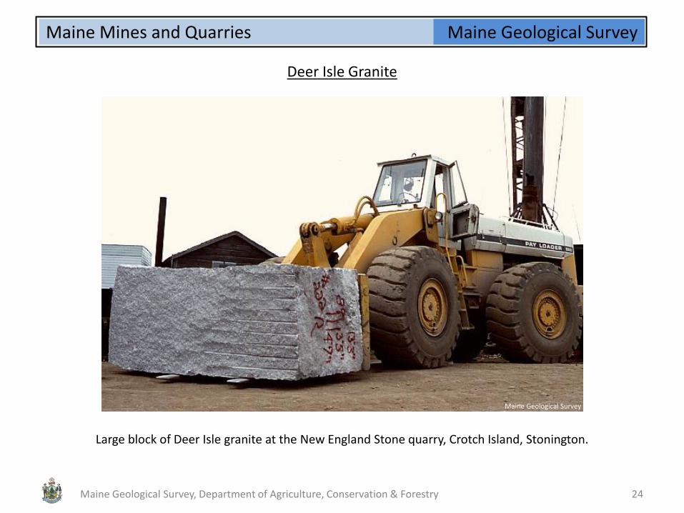
Deer Isle Granite
Large block of Deer Isle granite at the New England Stone quarry, Crotch Island, Stonington.
Maine Geological Survey
Maine Geological Survey, Department of Agriculture, Conservation & Forestry 24

Maine Geological Survey Maine Mines and Quarries
Merrill Slate Quarry
The Maine slate industry was also big in its day. From 1880 to 1904 Maine was among the top five slate-producing states in the country, providing slate of excellent quality for roofing tiles and other purposes. Many Maine homes and public buildings dating to that time are still protected by their original slate roofs. The "Central Maine Slate Belt" extends approximately from Waterville to Brownville Junction, with most activity having been in southern Piscataquis County. The photo above shows the Merrill Slate Quarry at Brownville
Ph
oto
fro
m T
. N. D
ale,
USG
S B
ulle
tin
27
5
Maine Geological Survey, Department of Agriculture, Conservation & Forestry 25

Maine Geological Survey Maine Mines and Quarries
Slate
Although most slate quarries in Maine have closed, there is still an active operation in Monson. The photo above shows slate slabs stockpiled at the Sheldon Slate Company.
Maine Geological Survey
Maine Geological Survey, Department of Agriculture, Conservation & Forestry 26

Maine Geological Survey Maine Mines and Quarries
Cutting Slate
Cutting slate at the Sheldon Slate Company, Monson.
Maine Geological Survey
Maine Geological Survey, Department of Agriculture, Conservation & Forestry 27
Maine Geological Survey Maine Mines and Quarries
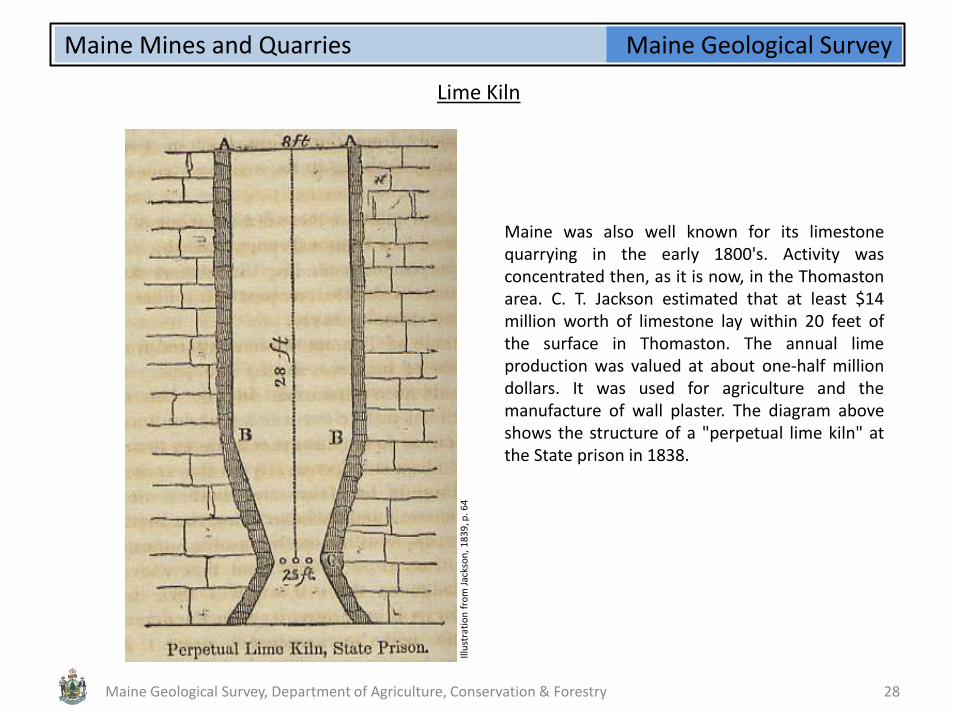
Lime Kiln
Maine was also well known for its limestone quarrying in the early 1800's. Activity was concentrated then, as it is now, in the Thomaston area. C. T. Jackson estimated that at least $14 million worth of limestone lay within 20 feet of the surface in Thomaston. The annual lime production was valued at about one-half million dollars. It was used for agriculture and the manufacture of wall plaster. The diagram above shows the structure of a "perpetual lime kiln" at the State prison in 1838.
Illu
stra
tio
n f
rom
Jac
kso
n, 1
83
9, p
. 64
Maine Geological Survey, Department of Agriculture, Conservation & Forestry 28

Maine Geological Survey Maine Mines and Quarries
Rockport Lime Kilns Sign
During the 1800's, Rockport was a major supplier of lime to markets on the East Coast. Lime kilns converted limestone from local quarries into lime used to produce mortar and plaster. The image above is a photo of an interpretive sign located at Rockport Marine Park. The drawing shows limestone being unloaded from rail cars into the kilns. The limestone was burned in the kilns to produce lime, which was then packed in casks and shipped to waiting markets.
Maine Geological Survey
Maine Geological Survey, Department of Agriculture, Conservation & Forestry 29
Maine Geological Survey

Maine Geological Survey Maine Mines and Quarries
Rockport Lime Kilns
A devastating fire in 1907 destroyed most of the wooden buildings surrounding the kilns. The local lime industry never recovered. The photo above shows some of the remaining kilns as they appear today in Rockport Marine Park.
Maine Geological Survey
Maine Geological Survey, Department of Agriculture, Conservation & Forestry 30

Maine Geological Survey Maine Mines and Quarries
Dragon Cement
The Dragon Cement plant in Thomaston is the only cement manufacturing plant in New England and has been in continuous operation since 1928. The adjacent limestone quarry provides rock of the necessary chemistry for cement manufacturing. This photo shows the marble (limestone) quarry, north of Route 1 in Thomaston, Me. The crushing mill and kiln can be seen in the background.
Maine Geological Survey
Maine Geological Survey, Department of Agriculture, Conservation & Forestry 31

Maine Geological Survey Maine Mines and Quarries
Blue Rock Quarry
The resource of greatest economic value in recent years is "aggregate," which is unconsolidated material such as sand, gravel, or crushed stone used for paving and construction. This photo shows the Blue Rock quarry between Westbrook and Portland. Biotite granofels of the Berwick Formation is quarried here for crushed rock aggregate. The Maine Turnpike is seen in the center of the photo.
Maine Geological Survey
Maine Geological Survey, Department of Agriculture, Conservation & Forestry 32

Maine Geological Survey Maine Mines and Quarries
Blue Rock Crushed Stone
Crushing and sorting equipment at the Blue Rock quarry in Westbrook.
Maine Geological Survey
Maine Geological Survey, Department of Agriculture, Conservation & Forestry 33

Maine Geological Survey Maine Mines and Quarries
Mount Mica
Mount Mica, near the village of Paris Hill, is home to one of the oldest gem tourmaline localities in the country, having been discovered in 1820. The quarry on Mount Mica has been worked intermittently for over 180 years. (postcard from early 1900's)
Maine Geological Survey
Maine Geological Survey, Department of Agriculture, Conservation & Forestry 34

Maine Geological Survey Maine Mines and Quarries
Mount Mica Pockets
In the early days at Mount Mica, many tourmaline pockets were found near the surface of the ground. Sticks mark locations of gem pockets.
Ph
oto
fro
m E
. S. B
asti
n, 1
91
1
Maine Geological Survey, Department of Agriculture, Conservation & Forestry 35
Maine Geological Survey Maine Mines and Quarries
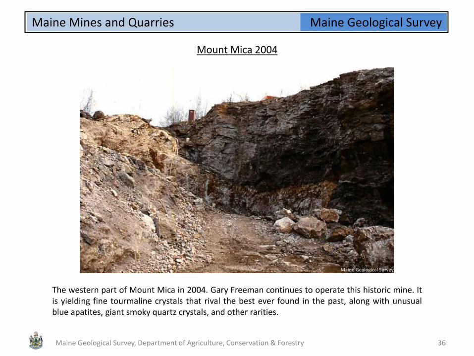
Mount Mica 2004
The western part of Mount Mica in 2004. Gary Freeman continues to operate this historic mine. It is yielding fine tourmaline crystals that rival the best ever found in the past, along with unusual blue apatites, giant smoky quartz crystals, and other rarities.
Maine Geological Survey
Maine Geological Survey, Department of Agriculture, Conservation & Forestry 36

Maine Geological Survey Maine Mines and Quarries
Giant Tourmaline
Mary Freeman holding a giant tourmaline specimen just after its discovery at Mount Mica. Specimens from the tourmaline pockets usually are not colorful and sparkly when they are fresh out of the ground. Cleaning is required at the end of the day to remove coatings of rust and mud from both minerals and miners!
Ph
oto
co
urt
esy
of
G. F
reem
an
Maine Geological Survey, Department of Agriculture, Conservation & Forestry 37

Maine Geological Survey Maine Mines and Quarries
Cleaned Giant Tourmaline
The same specimen seen in previous photo, after cleaning. It shows a columnar pink and green tourmaline crystal with a matrix of quartz crystals. The shape and color scheme of this crystal resemble a large tourmaline found at Mount Mica by Loren Merrill in 1904 and now in the collection of Harvard University.
Ph
oto
co
urt
esy
of
G. F
reem
an
Maine Geological Survey, Department of Agriculture, Conservation & Forestry 38

Maine Geological Survey Maine Mines and Quarries
Feldspar Mill
The feldspar mill in West Paris, constructed in 1925 for the Oxford Mining and Milling Company, was important in the development of the feldspar industry in Oxford County. In the 1980's, Industrial Garnet Extractives developed the Wing Hill Mine in Rangeley for garnet-bearing diorite. The garnet was separated at the Bell Minerals Company feldspar mill in West Paris, and was used for a variety of industrial products including water filters, abrasives, and packing media. This operation was one of four garnet producers in the United States. It closed in May, 1988 due to supply and milling problems. The mill was inactive when this photo was taken (1990).
Maine Geological Survey
Maine Geological Survey, Department of Agriculture, Conservation & Forestry 39
Ph
oto
by
Wo
od
row
B. T
ho
mp
son

Maine Geological Survey Maine Mines and Quarries
Tamminen Quarry
Feldspar mining operation at the Tamminen Quarry, Greenwood, 1952. Note trays loaded with feldspar, next to derrick.
Maine Geological Survey
Maine Geological Survey, Department of Agriculture, Conservation & Forestry 40
Ph
oto
by
Nei
l win
trin
gham

Maine Geological Survey Maine Mines and Quarries
Topsham Gravel Pit
Sand and gravel is a basic component of concrete used in commercial and industrial buildings and public works projects. It also receives wide use as a base material in the construction and repair of highways, railways and airport runways. In Maine, this has been the resource with the greatest economic value in recent years. Glacial sand and gravel deposits across the state have been mined for this purpose. This photo shows a very large gravel pit near the Androscoggin River in Topsham.
Maine Geological Survey
Maine Geological Survey, Department of Agriculture, Conservation & Forestry 41

Maine Geological Survey Maine Mines and Quarries
Whitefield Gravel Pit
Gravel size sorting operation in a pit in the Palmer Hill delta in Whitefield.
Maine Geological Survey
Maine Geological Survey, Department of Agriculture, Conservation & Forestry 42

Maine Geological Survey Maine Mines and Quarries
Clay Deposits
Clay has been mined in Maine for well over a century. Clay deposits are widespread in Maine's coastal counties, particularly in the Presumpscot Formation of Pleistocene age. This formation originated as finely ground "rock flour" produced by glacial abrasion, and has a complex mineral makeup. This clay is quite suitable for common brick made in local brickyards. The photo shows an exposure of Presumpscot Formation clay in Gardiner.
Maine Geological Survey
Maine Geological Survey, Department of Agriculture, Conservation & Forestry 43
Maine Geological Survey Maine Mines and Quarries
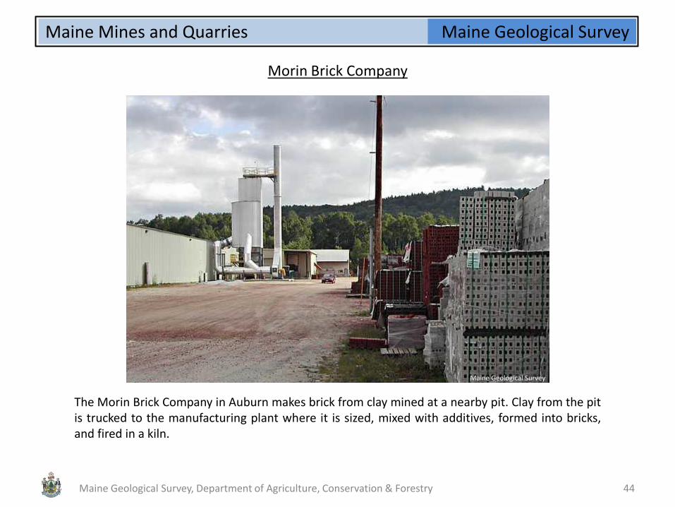
Morin Brick Company
The Morin Brick Company in Auburn makes brick from clay mined at a nearby pit. Clay from the pit is trucked to the manufacturing plant where it is sized, mixed with additives, formed into bricks, and fired in a kiln.
Maine Geological Survey
Maine Geological Survey, Department of Agriculture, Conservation & Forestry 44

Maine Geological Survey Maine Mines and Quarries
Colby College
The buildings of Colby College in Waterville are constructed of brick produced by the Morin Brick Company. It is estimated that the campus is built of some 50 million Maine-made "Colby" bricks.
Maine Geological Survey
Maine Geological Survey, Department of Agriculture, Conservation & Forestry 45

Maine Geological Survey Maine Mines and Quarries
Peat Harvester
Peat was harvested in a number of Maine towns during the early 1940's, including Centerville, Deblois, Franklin, Friendship, Jonesport, Penobscot, and Sullivan. Harvesting of peat for agricultural uses has continued on a limited basis until the present day. The photo above shows a peat harvester on the Denbo Heath in 1980.
Maine Geological Survey
Maine Geological Survey, Department of Agriculture, Conservation & Forestry 46

Maine Geological Survey Maine Mines and Quarries
Martian Bigfoot
A variety of equipment has been used to harvest peat in Maine. One of the most interesting was the "Martian Bigfoot," shown here on Denbo Heath in 1980.
Maine Geological Survey
Maine Geological Survey, Department of Agriculture, Conservation & Forestry 47
Maine Geological Survey Maine Mines and Quarries
References
Bastin, Edson Sunderland, 1911, Geology of the pegmatites and associated rocks of Maine, including feldspar, quartz, mica, and gem deposits; U. S. Geological Survey, Bulletin 445, 152 p. Blanding, E. M., and Blanding, W. F. (editors), 1880, Maine Mining Journal; A weekly newspaper devoted to mining, published from January 3, 1880, to September 22, 1882, 28 West Market Square, Bangor, Maine Dale, Thomas Nelson, 1906, Slate deposits and slate industry of the United States [Maine]; U. S. Geological Survey, Bulletin 275, p. 60-67, 123-131. Dale, Thomas Nelson, 1907, The granites of Maine; U. S. Geological Survey, Bulletin 313, 202 p. Hamlin, Augustus Choate, 1873, The tourmaline; Its relation as a gem; its complex nature; its wonderful physical properties, etc., etc.,; with special reference to the beautiful and matchless crystals found in the State of Maine; James R. Osgood and Co., Boston, Massachusetts, 107 p. Jackson, Charles T., 1837, List of mines and minerals belonging to the Maine Mining Co.; Boston, 16 p. Jackson, Charles T., 1839, Third annual report on the geology of the State of Maine; Smith & Robinson, Printers to the State, Augusta, Maine, 276 p. King, Vandall T., and Foord, Eugene E., 1994, Mineralogy of Maine Volume 1: Descriptive Mineralogy: Maine Geological Survey (Department of Conservation), 418 p.
Maine Geological Survey, Department of Agriculture, Conservation & Forestry 48