
Virginia Department of Transportation · Virginia Department of Transportation ... interchange....
23
Transcript of Virginia Department of Transportation · Virginia Department of Transportation ... interchange....


Virginia Department of Transportation
Fairfax County Parkway Interchange
Improvements Project
NOISE ANALYSIS TECHNICAL REPORT
State Project 0095-029-890, PE-101;
UPC 96259
Prepared for:
Virginia Department of Transportation
Environmental Division
1401 East Broad Street
Richmond, VA 23219
April 2012

TABLE OF CONTENTS
I. Executive Summary........................................................................................................ 1
II. Introduction..................................................................................................................... 2
III. Noise Analysis Methodology, Terminology and Criteria............................................... 7
IV. Validation and Existing Conditions.............................................................................. 11
V. Evaluation of Design Year Noise Levels & Noise Impact Assessment ....................... 15
VI. Construction Noise ....................................................................................................... 17
VII. Public Involvement/Local Officials Coordination........................................................ 18
VIII. Noise Contours ............................................................................................................. 19
IX. Conclusion .................................................................................................................... 20
TABLES
Table 1 – FHWA/VDOT Noise Abatement Criteria ...................................................................... 8
Table 2 – Sound Level Summary in decibels (dB(A)) ..................................................................14
Table 3 – CNE-Specific Noise Contours ......................................................................................19
FIGURES
Figure 1 – Regional Location Map ..................................................................................................3
Figure 2A/Option 1 – Design Year Build (2040), I-95/Fairfax County Pkwy Int. ........................ 4
Figure 2B/Option 2 – Design Year Build (2040), I-95/Fairfax County Pkwy Int. ........................ 5
Figure 3 – Design Year Build (2040), Rolling Road/Franconia-Springfield Pkwy Int. ................ 6
APPENDICES
Appendix A - Noise Meter and Acoustical Calibrator Calibration Certificates
Appendix B - Noise Monitoring Data Forms
Appendix C - Noise Monitoring Data (2008 and 2011) Metrosonics Printouts
Appendix D - Traffic Data Summary
Appendix E - TNM Model Printouts
Appendix F - References
Appendix G - List of Preparers/Reviewers

Fairfax County Parkway Interchange Improvements Project 1
Noise Analysis Technical Report
Fairfax County, VA
I. Executive Summary
The Virginia Department of Transportation (VDOT) and the Federal Highway Administration
(FHWA) have identified two interchange improvements to promote safe and efficient traffic flow
along the Fairfax County Parkway in Fairfax County, Virginia. Fairfax County Parkway is
currently undergoing a route designation change. It is currently Route 7100, but will be changed
to Route 286. Similarly, Franconia-Springfield Parkway is currently Route 7900, but will be
changed to Route 289. This report will be using the updated route numbers for these roads. The
project includes two existing interchanges that are located at the southern and northern ends of a
segment of the Fairfax County Parkway (Route 286) recently constructed through the Fort
Belvoir North Area in Fairfax County. The first of these is at Exit 166 in Newington on Interstate
95 and the proposed improvements would entail constructing a flyover ramp to carry traffic from
northbound I-95 to westbound Fairfax County Parkway. The second interchange is at Rolling
Road (Route 638) and the proposed improvements would include widening the existing single-
lane loop ramp from northbound Rolling Road to westbound Fairfax County Parkway to two
lanes and widening and extending the merge area to westbound Fairfax County Parkway. The
locations of these improvements can be referenced in Figures 1, 2A, 2B, and 3.
This report documents the Existing and Design Year noise levels associated with both of the
proposed interchange improvements. Noise monitoring was performed at nine locations, while
noise modeling-only was conducted at sixteen additional sites to gain a thorough understanding
of the existing noise environment. A project field view was performed to examine the project
area, as well as to document major sources of acoustic shielding (e.g., terrain lines, building
rows, etc.). Noise modeling was completed for Existing (2011), Design Year No-Build (2040),
and Design Year Build (2040) conditions.
Existing (2011) worst-case noise levels do not approach or exceed VDOT/FHWA Noise
Abatement Criteria (NAC) at any of the receptors in the project area. Design Year No-Build
(2040) noise levels do not approach or exceed the NAC at any of the receptor sites in the project
area. Forecasted traffic volumes under Design Year No-Build and Build (2040) conditions are
nearly identical, resulting in similar noise levels.
Design year noise levels were predicted at each monitored and modeled receptor site at the
sensitive receptors in the project area. As identified in Table 2 Column 9, Design Year Build
(2040) noise levels are not projected to approach or exceed the NAC at any receptor sites.
Because design year noise levels are not projected to exceed the NAC for any receptor sites, no
noise mitigation is being considered at this time. During the Final Design Phase, all areas of the
project will be reconsidered in light of more detailed designs, refined project alignments, and re-
analysis of the roadway/noise receptor relationships.

Fairfax County Parkway Interchange Improvements Project 2
Noise Analysis Technical Report
Fairfax County, VA
II. Introduction
Impacts associated with noise are often a prime concern when evaluating roadway improvement
projects. Roadway construction at a new location or improvements to the existing transportation
network may cause impacts to the noise-sensitive environment located adjacent to the project
area. For this reason, FHWA and VDOT have established a noise analysis methodology and
associated noise level criteria to assess the potential noise impacts associated with the
construction and use of transportation projects.
FHWA and VDOT have identified two interchange improvements, located approximately two
miles apart, to promote safe and efficient traffic flow along the Fairfax County Parkway in
Fairfax County, Virginia. Both project locations can be seen in Figure 1-Regional Location
Map. The project study area consists primarily of single and multi-family residences. Two
design options have been designated for the Fairfax County Parkway (Route 286) / Interstate 95
(I-95) (Exit 166) Interchange, both of which include a single-lane “flyover” ramp from
northbound I-95 to westbound Fairfax County Parkway:
Option 1 would involve leaving the existing loop ramp open so that I-95 northbound traffic could
continue to reach northbound Backlick Road and also access the future Boudinot Drive
interchange. Figure 2A shows the proposed alignment and lane designations of this option.
Option 2 would involve eliminating the existing loop ramp and constructing left-turn lanes at the
terminus of the existing ramp from I-95 northbound to eastbound Fairfax County Parkway and
Loisdale Road. Left turns are not currently permitted at this intersection. Figure 2B shows the
proposed alignment and lane designations of this option.
At the Rolling Road (Route 638) / Franconia-Springfield Parkway (Route 289) interchange, a
new travel lane will be added to an existing single-lane loop ramp that allows traffic on the
Fairfax County Parkway to continue on the westbound Fairfax County Parkway at the junction
with Rolling Road and the Franconia-Springfield Parkway. Minor improvements will also be
made on the Fairfax County Parkway westbound lanes in this area to provide the necessary
transitions to the existing roadway network.
This report details the steps involved in the preliminary noise analysis for the Fairfax County
Parkway Interchange Improvements Project, including noise monitoring/modeling
methodologies, results, impact evaluation, and potential abatement consideration.
This report provides the results for the reevaluation of the project, which involves updated
Design Year (2040) traffic and additional Common Noise Environments (CNE) along Tanworth
Court, Jillspring Court, and Stream Way.

Fairfax County Parkway Interchange Improvements Project 3
Noise Analysis Technical Report
Fairfax County, VA

Fairfax County Parkway Interchange Improvements Project
Noise Analysis Technical Report
Fairfax County, VA
4

Fairfax County Parkway Interchange Improvements Project
Noise Analysis Technical Report
Fairfax County, VA
5
Fairfax County Parkway Interchange Improvements Project
Noise Analysis Technical Report
Fairfax County, VA
6

Fairfax County Parkway Interchange Improvements Project 7
Noise Analysis Technical Report
Fairfax County, VA
III. Noise Analysis Methodology, Terminology and Criteria
The methodologies applied to the noise analysis for both interchange improvements are in
accordance with VDOT’s “State Noise Abatement Policy”, effective July 13, 2011 and updated
September 2011. VDOT guidelines are based on Title 23 of the Code of Federal Regulations,
Part 772 and the Federal Highway Administration’s Procedures for Abatement of Highway
Traffic Noise and Construction Noise (23 CFR 772).
To determine the degree of highway noise impact, Noise Abatement Criteria (NAC) has been
established for a number of different land use categories. Table 1 documents the NAC for the
associated activity land use category shown in the adjacent column. Land use adjacent to the
Fairfax County Parkway (Route 286)/ I-95 (Exit 166) portion of the project consists of a
hotel/motel, the former Hunter Motel, which is to be replaced with an Embassy Suites. Adjacent
to the Rolling Road portion of the project are residential land uses, both single and multi-family.
Therefore, land uses within the project areas are considered Category B and Category E.
Category B receptors are comprised of and limited to residential areas, while Category E land
uses consist of hotels, motels, restaurants, bars, and other developed lands.
The NAC are given in terms of an hourly, A-weighted, equivalent sound level. The A-weighted
sound level frequency is used for human use areas because it is comprised of the sound level
frequencies that are most easily distinguished by the human ear, out of the entire sound level
spectrum. Highway traffic noise is categorized as a linear noise source, where varying noise
levels occur at a fixed point during a single vehicle pass by. It is acceptable to characterize these
fluctuating noise levels with a single number known as the equivalent noise level (Leq). The Leq
is the value of a steady sound level that would represent the same sound energy as the actual
time-varying sound evaluated over the same time period. For highway noise assessments, Leq is
typically evaluated over a one-hour period.

Fairfax County Parkway Interchange Improvements Project 8
Noise Analysis Technical Report
Fairfax County, VA
TABLE 1
Fairfax County Parkway Interchange Improvements Project
FHWA/VDOT Noise Abatement Criteria
Hourly-A-Weighted Sound Level in Decibels (dB(A))1
Activity
Category
Activity
Leq (h)* Criteria
2
L10 (h)
Evaluation
Location Description of Activity Category
A 57 60 Exterior
Lands on which serenity and quiet are of
extraordinary significance and serve an important
public need and where the preservation of those
qualities is essential if the area is to continue to serve
its intended purpose.
B3 67 70 Exterior Residential.
C3 67 70 Exterior
Active sport areas, amphitheaters, auditoriums,
campgrounds, cemeteries, day care centers, hospitals,
libraries, medical facilities, parks, picnic areas, places
of worship, public meeting rooms, public or non-
profit institutional structures, radio studios, recording
studios, recreation areas, Section 4(f) sites, schools,
television studios, trails, and trail crossings.
D 52 55 Interior
Auditoriums, day care centers, hospitals, libraries,
medical facilities, places of worship, public meeting
rooms, public or non-profit institutional structures,
radio studios, recording studios, schools, and
television studios.
E3 72 75 Exterior
Hotels, motels, offices, restaurants/bars, and other
developed lands, properties of activities not included
in A-D or F.
F -- -- Exterior
Agriculture, airports, bus yards, emergency services,
industrial logging, maintenance facilities,
manufacturing, mining, rail yards, retail facilities,
shipyards, utilities (water resources, water treatment,
electrical), and warehousing.
G -- -- -- Undeveloped lands that are not permitted.
1 Either Leq (h) or L10 (h) (but not both) may be used on a project.
2
The Leq (h) and L10 (h) Activity Criteria values are for impact determination only and are not design
standards for noise abatement measure. 3 Includes undeveloped lands permitted for this Activity Criteria.
* VDOT utilizes the Leq(h) designation.

Fairfax County Parkway Interchange Improvements Project 9
Noise Analysis Technical Report
Fairfax County, VA
Noise abatement determination is based on VDOT’s three-phase approach. The first phase
(Phase 1) distinguishes if a sensitive receptor within a project area warrants highway traffic
noise abatement. The following describes the Phase 1 warranted criterion, as discussed in
VDOT policy. Receptors that satisfy either condition warrants consideration of highway traffic
noise abatement.
• Predicted highway traffic noise levels (for the design year) approach or exceed the
highway traffic noise abatement criteria in Table 1. “Approach” has been defined by
VDOT as 1 dB(A) below the noise abatement criteria.
~or~
• A substantial noise increase has been defined by VDOT as a 10 dB(A) increase above
existing noise levels for all noise-sensitive exterior activity categories. A 10 dB(A)
increase in noise reflects the generally accepted range of a perceived doubling of the
loudness.
The identification of noise-sensitive land uses and the location of the existing interchanges
guided the selection of noise monitoring locations along the project area. In order to determine
the existing noise conditions within the project area, noise monitoring was conducted at nine
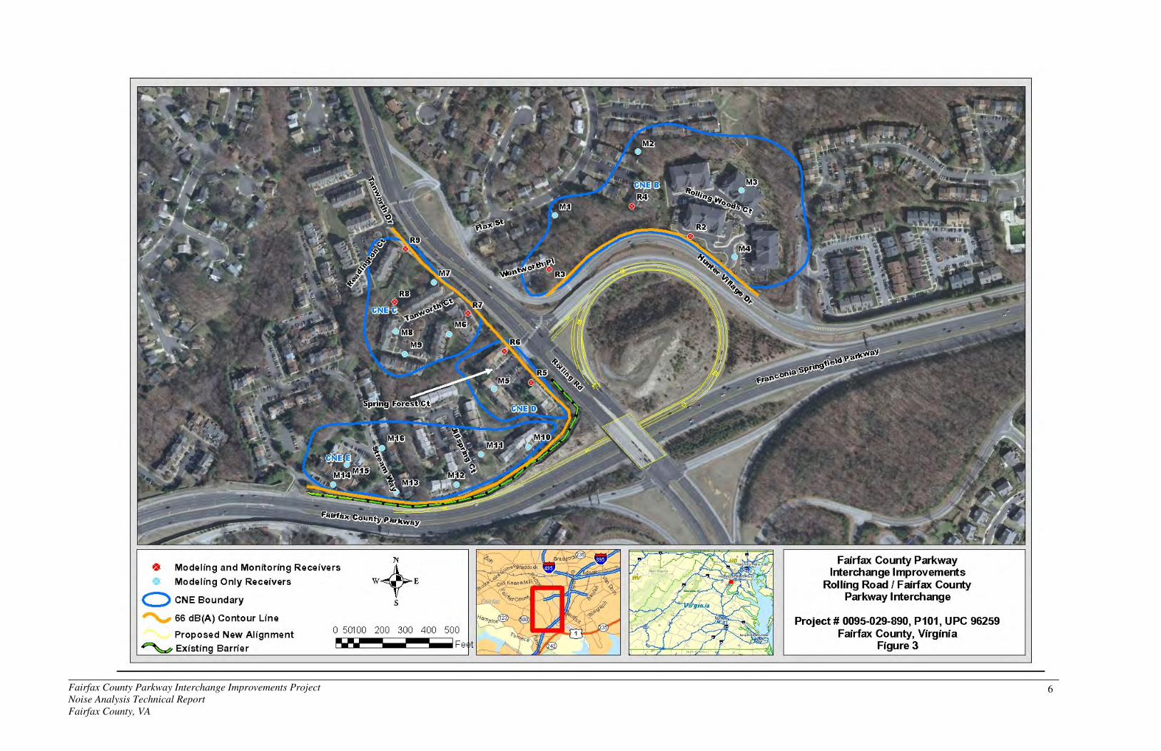
representative noise-sensitive receptor sites. Figure 2A, Figure 2B, and Figure 3 identify the
project area and the locations of the nine noise monitoring sites (R1 – R9). Monitoring was performed at each of the selected noise sensitive receptors using the Metrosonics
dB-3080 dosimeters. Readings were taken on the A-weighted scale and reported in decibels
(dB(A)). Prior to noise monitoring, noise meters were calibrated using a Metrosonics cl-304
acoustical calibrator. The noise monitoring equipment meets all requirements of the American
National Standard Specifications for Type 2 Sound Level Meters, ANSI S1.4-1983 (R1991), as
defined by FHWA. Noise monitoring was conducted in accordance with the methodologies
contained in FHWA-PD-96-046, Measurement of Highway-Related Noise (FHWA, May 1996).
By placing the meters as close to the existing roadways as practical, the monitoring site locations
provided an absolute worst-case existing noise level adjacent to the existing roadway corridor
and allowed for minimal influence from background noise sources. The short-term noise
monitoring focused on the morning rush hour, as the field testing concluded that traffic volumes
during the AM peak period represented the worst-case condition.
The AM peak period monitoring was performed between 6:00 AM and 9:00 AM on September
17, 2008. Supplemental noise monitoring was performed on December 14, 2011 to account for
the Tanworth Court residences. Monitoring was conducted at each site for a 10 or 15-minute
duration within each of the monitoring periods. Noise levels were recorded at 10-second
intervals for the duration of each test. Data collected by the sound analyzers included time,
average noise level (Lav), maximum noise level (Lmax), and instantaneous peak noise level (Lpk)
for each recorded interval. Additional data collected at each monitoring location included
atmospheric conditions, wind speed, background noise sources, and unusual/atypical noise
events. Traffic data (vehicle volume and speed) were also recorded on all roadways that were

Fairfax County Parkway Interchange Improvements Project 10
Noise Analysis Technical Report
Fairfax County, VA
visible from the monitoring sites and significantly contributed to the overall noise levels. Traffic
was grouped into one of three categories: cars, medium trucks, and heavy trucks, as per VDOT
procedures. Combined, all of this data is used during the noise model validation process.
Short-term noise monitoring is not a process to determine design year noise impacts or barrier
locations. Short-term noise monitoring provides a level of consistency between what is present
in real-world situations and how that is represented in the computer noise model. Short-term
monitoring does not need to occur within every CNE to validate the computer noise model.

Fairfax County Parkway Interchange Improvements Project 11
Noise Analysis Technical Report
Fairfax County, VA
IV. Validation and Existing Conditions
Computer modeling is the accepted technique for predicting Existing and Design Year noise
levels associated with traffic-induced noise. Currently, the FHWA Traffic Noise Model (TNM)
2.5 computer-modeling program is the approved highway noise prediction model. The TNM has
been established as a reliable tool for representing noise generated by highway traffic. The
information applied to the modeling effort includes the following: highway design files (existing
and proposed conceptual design), traffic data, roadway cross-sections, and surveying of terrain.
Base mapping, aerial photography, and field views were used to identify noise-sensitive land
uses within the corridor and any terrain features that may shield roadway noise. Most of the land
uses within the project area are residential, and thus will be categorized as Category B. The
hotel/motel will be categorized as Category E.
The modeling process begins with model validation, as per VDOT requirements. This is
accomplished by comparing the monitored noise levels with noise levels generated by the
computer model, using the traffic volume, speeds, and composition that were witnessed during
the monitoring effort. This comparison ensures that reported changes in noise levels between
Existing and Design Year conditions are due to changes in traffic conditions and not to
discrepancies between monitoring and modeling techniques. A difference of three decibels (3
dB(A)) or less between the monitored and modeled level is considered acceptable since this is
the limit of change detectable by the typical human ear. Table 2 provides a summary of the
model validation for the Existing (2008 and 2011) monitored conditions. Column 5 represents
the difference between the monitored level (Column 3) and the modeled level produced by the
noise model (Column 4). Since all nine of the analyzed receptors show a 3-dB(A) difference or
less between the monitored and modeled noise levels, the model is considered to be an accurate
representation of actual existing conditions throughout the project area.
The validated noise model is the base noise model for the remainder of the preliminary noise
analysis. Additional modeling sites were added to the validated model to thoroughly predict
existing noise levels throughout the project area. This additional noise modeling was performed
for existing conditions using traffic data supplied by traffic engineers (reference Appendix D).
This modeling step was performed to evaluate existing “worst-case” conditions associated with
existing worst-case traffic volumes and composition. Column 6 of Table 2 provides a summary
of worst-case existing noise levels, based on supplied worst-case existing traffic volumes. Based
on these existing noise levels, the noise impact criterion (Column 7) was determined at each
receptor site, based on either the “absolute” criteria shown in Table 1 or VDOT’s “substantial
increase” above existing conditions criterion.
Traffic noise levels were predicted at all noise-sensitive land uses with the project area, using the
latest version of the FHWA TNM 2.5. Field views and noise monitoring trips were conducted on
September 17, 2008 and December 14, 2011 to determine the relationship of these sensitive land
uses to the existing roadway network. Existing worst-case (2011) noise levels were determined
by incorporating field reconnaissance of the existing transportation network into the noise model.
Major and secondary roadways in close proximity to receptor sites that carry considerable traffic
volumes were added to the noise model. For the purposes of this noise analysis, it was
Fairfax County Parkway Interchange Improvements Project 12
Noise Analysis Technical Report
Fairfax County, VA
determined through field verification that I-95, Fairfax County Parkway, and Rolling Road are
the dominant noise sources for this project area.
Traffic data supplied by traffic engineers, including volumes, speeds, and composition, were
added to the noise model to predict existing noise levels for the year 2011 throughout the project
corridor. Posted roadway speeds were identified during the field view and were also
incorporated into the noise model. No Build and Build Design Year volumes are very similar due
to the fact that one model was used and the volumes were re-distributed as appropriate to account
for the new flyover or additional ramp lane. It was not anticipated that the project would create
an increase in traffic.
In addition to the nine receptor sites used for monitoring purposes, sixteen additional sites were
modeled to adequately cover the project area and to predict the depth of noise impact, if any.
Base mapping, aerial photography, and field views were used to identify noise-sensitive land
uses within the corridor and any terrain features that may shield roadway noise. The modeling-
only sites that were selected represent both first and second row Category B land uses in the
northern portion of the project in the vicinity of the Franconia-Springfield and Fairfax County
Parkways and Rolling Road. The modeling-only sites are represented by an “M” and can be
referenced in Figure 3.
The following is a discussion of the existing noise environment for each Common Noise
Environment (CNE) that was evaluated for the Fairfax County Parkway Interchange
Improvements Project. CNEs are groupings of receptor sites that, by location, form distinct
communities within the project area and have a common noise environment. These areas are
used to evaluate traffic noise impacts and potential noise abatement options to residential
developments or communities as a whole, and to assess the feasibility and reasonableness of
possible noise abatement measures for specific communities. Where residential communities or
groupings of noise-sensitive land uses exist, both noise monitoring and noise modeling-only sites
were grouped into CNEs. All of the residences discussed below are two-story town homes that
do not have any second floor balconies, therefore no receptor heights (above ground) higher than
the TNM default of 4.92 feet was used in the modeling.
CNE A
Common Noise Environment A (CNE A) contains the former Hunter Motel (represented by
receptor site R1) between Loisdale Road and I-95 in the southernmost portion of the project
corridor. The location of this CNE and receptor site R1 can be seen in Figure 2A and 2B. The
Existing (2008) monitored noise level within CNE A is 61 dB(A), as shown in Column 3 of
Table 2. Column 6 of Table 2 shows that existing (2011) worst-case modeled noise levels
within CNE A is 65 dB(A).
CNE B
Common Noise Environment B (CNE B) ranges from approximately Gerardia Court to Flax
Street in the northernmost portion of the project corridor. CNE B contains three noise

Fairfax County Parkway Interchange Improvements Project 13
Noise Analysis Technical Report
Fairfax County, VA
monitoring sites (R2, R3, and R4) and four modeling-only sites representing 61 residences.
Monitored receptor sites R2 and R3 represent front-row residences. The locations of these sites
can be seen in Figure 3. Existing (2008) monitored noise levels within CNE B were found to
range from 50 to 57 dB(A), as shown in Column 3 of Table 2. Column 6 of Table 2 shows that
existing (2011) worst-case modeled noise levels within CNE B range from 49 to 60 dB(A).
CNE C
As a part of the reevaluation, Common Noise Environment C (CNE C) was added. CNE C is
located to the west of Rolling Road, along Tanworth Court and Readington Court. CNE C
contains three monitoring sites, R7, R8, and R9 and four modeling-only sites representing 44
residences. Sites R7 and R9 represent front row residences, while site R8 represents second-row
residences. The locations of these receptor sites can be seen in Figure 3. Existing (2011)
monitored noise levels within CNE C range from 53 to 63 dB(A), as shown in Column 3 of
Table 2. Column 6 of Table 2 shows that existing (2011) worst-case modeled noise levels
within CNE C range from 54 to 65 dB(A).
CNE D
Common Noise Environment D (CNE D) is situated adjacent to the westbound lanes of the
Fairfax County Parkway and the southbound lanes of Rolling Road, in the northernmost portion
of the project corridor. CNE D contains two noise monitoring sites (R5 and R6) representing
nine residences and one modeling-only site representing eight residences. The locations of these
sites can be seen in Figure 3. Existing (2008) monitored noise levels within CNE D were found
to range from 56 to 59 dB(A), as shown in Column 3 of Table 2. Column 6 of Table 2 shows
that existing (2011) worst-case modeled noise levels within CNE D range from 54 to 61 dB(A).
CNE E
As part of the reevaluation, Common Noise Environment E (CNE E) was added. CNE E is
located north of the westbound lanes of Fairfax County Parkway, just west of the Rolling Road
overpass. CNE E contains 7 modeling-only sites representing 51 residences. The locations of
these sites can be seen in Figure 3. Column 6 of Table 2 shows that existing (2011) worst-case
modeled noise levels with CNE E range from 55 to 64 dB(A).
Residences within CNE E and a portion of CNE D are currently protected by an existing noise
barrier that runs adjacent to a portion of Rolling Road and transitions to the Fairfax County
Parkway westbound edge of shoulder to its termination point near the entrance to Stream Way.
The barrier’s length is approximately 1,500 feet and it has a maximum height of 10 feet. The
location of this barrier can be seen in Figure 3.

Fairfax County Parkway Interchange Improvements Project 14
Noise Analysis Technical Report
Fairfax County, VA
1 2 3 4 5 6 7 8 9
Receptor
Site
Number of
Residences
Monitored
Noise Level
Modeled
Noise Level
Difference
(Mon. -
Mod.)
Existing
Worst-Case
Noise Level
Onset of
Criteria
Design Year
(2040) No-Build
Noise Level
Design Year (2040)
Build Noise Level
65*
65**
R2 12 55 53 2.7 60 65 (1)
61 62
R3 12 57 55 1.4 57 66 59 59
R4 6 50 47 2.6 52 60 (1)
55 55
M1 3 -- -- -- 52 66 54 54
M2 4 -- -- -- 49 66 51 51
M3 12 -- -- -- 53 66 54 54
M4 12 -- -- -- 60 66 62 62
R7 7 59 60 -1.4 62 66 62 63
R8 4 53 53 -0.1 56 63 (1)
56 56
R9 8 63 63 -0.8 65 66 65 65
M6 7 -- -- -- 57 66 57 57
M7 4 -- -- -- 64 66 64 65
M8 6 -- -- -- 54 66 54 55
M9 8 -- -- -- 54 66 54 54
R5 6 56 58.7 -2.8 60 66 62 62
R6 3 59 60.3 -1.6 61 66 63 63
M5 8 -- -- -- 54 66 56 56
M10 7 -- -- -- 57 66 58 58
M11 6 -- -- -- 55 66 56 56
M12 6 -- -- -- 58 66 59 58
M13 5 -- -- -- 58 66 59 59
M14 10 -- -- -- 64 66 65 65
M15 8 -- -- -- 61 66 62 62
M16 9 -- -- -- 56 66 57 57(1)
The criterion is based on the 'substantial increase' criterion, an overall increase of 10 dBA when comparing existing to future project-related noise levels.
* Option 1 - maintain existing loop ramp.
** Option 2 - eliminate existing loop ramp.
71 65
CNE D
CNE E
CNE B
CNE A
Sound Level Summary in dB(A)
Fairfax County Parkway Interchange Improvements Project
Table 2
CNE C
R1 Hotel 61 63 -2.1 65

Fairfax County Parkway Interchange Improvements Project
Noise Analysis Technical Report
Fairfax County, VA
15
V. Evaluation of Design Year Noise Levels & Noise Impact Assessment
Following the development of the existing conditions model and the prediction of the Existing
(worst-case) noise levels, the assessment continued with the projection of Design Year (2040)
noise levels. This task was accomplished by accounting for the proposed improvements and
applying Design Year (2040) traffic volumes and composition to the validated computer model.
The proposed improvements should be considered conceptual and preliminary in nature. Design
Year (2040) Build noise levels were predicted with the conceptual improvements in place and in
use.
Upon coordinating with the locality, it was determined that no new construction is currently
underway or permitted.
Design Year (2040) noise levels were modeled for the No-Build alternative for comparative
purposes to Build conditions. The No-Build alternative was modeled with the assumption that
the roadway improvements proposed as part of the VDOT project would not be in place in
Design Year (2040) of the project, but the existing roadways would carry Design Year traffic
volumes, speeds, and composition. The noise levels associated with the No-Build modeling
analysis are summarized in Column 8 of Table 2. No-Build noise levels are not projected to
approach or exceed the FHWA/VDOT NAC in any of the CNEs.
The next step in the noise analysis was to project Design Year (2040) build noise levels and to
determine if receptors will approach or exceed the NAC. If the criteria are approached or
exceeded at any receptor, noise abatement would be considered and evaluated in an attempt to
reduce Design Year (2040) noise levels. The noise levels associated with the Build modeling
analysis are summarized in Column 9 of Table 2. As shown, Design Year (2040) Build noise
levels are not projected to approach or exceed the NAC in any of the CNEs.
The following is a discussion of the Design Year No-Build (2040) and Design Year Build (2040)
noise levels for each Common Noise Environment.
CNE A
Common Noise Environment A (CNE A) contains the former Hunter Motel (represented by
receptor site R1) between Loisdale Road and I-95 in the southernmost portion of the project
corridor. The location of this CNE and receptor site R1 can be seen in Figure 2A and 2B. The
Design Year No-Build (2040) modeled noise level within CNE A is 65 dB(A), as shown in
Column 8 of Table 2. The Design Year (2040) Build modeled noise level within CNE A is 65
dB(A) for Option 1 and 65 dB(A) for Option 2, as shown in Column 9 of Table 2.
CNE B
Common Noise Environment B (CNE B) ranges from approximately Gerardia Court to Flax
Street in the northernmost portion of the project corridor. CNE B contains three noise
monitoring sites (R2, R3, and R4) and four noise modeling-only sites (M1, M2, M3, and M4),

Fairfax County Parkway Interchange Improvements Project
Noise Analysis Technical Report
Fairfax County, VA
16
which combined represent 61 residences. Both monitored receptor sites R2 and R3 and
modeling-only site M-4 represent front-row residences. The locations of these receptor sites can
be seen in Figure 3. The Design Year No-Build (2040) modeled noise levels within CNE B
range from 51 to 62 dB(A), as shown in Column 8 of Table 2. The Design Year (2040) Build
modeled noise levels within CNE B range from 51 to 62 dB(A), as shown in Column 9 of Table
2.
CNE C
Common Noise Environment C (CNE C) is located to the west of Rolling Road, along Tanworth
Court and Readington Court. CNE C contains three monitoring sites, R7, R8, and R9 and four
modeling-only sites representing 44 residences. Sites R7 and R9 represent front-row residences,
while site R8 represents second-row residences. The locations of these receptor sites can be seen
in Figure 3. The Design Year No-Build (2040) modeled noise levels within CNE C range from
54 to 65 dB(A), as shown in Column 8 of Table 2. The Design Year (2040) Build modeled
noise levels within CNE C range from 54 to 65 dB(A), as shown in Column 9 of Table 2.
CNE D
Common Noise Environment D (CNE D) is situated adjacent to the westbound lanes of the
Fairfax County Parkway and the southbound lanes of Rolling Road, in the northernmost portion
of the project corridor. CNE D contains two noise monitoring sites (R5 and R6) and one noise
modeling-only site (M-5), which combined represent 17 residences. Both monitored receptor
sites represent front-row residences. The locations of these receptor sites can be seen in Figure
3. The Design Year No-Build (2040) modeled noise levels within CNE D range from 56 to 63
dB(A), as shown in Column 8 of Table 2. The Design Year (2040) Build modeled noise levels
within CNE D range from 56 to 63 dB(A), as shown in Column 9 of Table 2.
CNE E
Common Noise Environment E (CNE E) is located north of the westbound lanes of Fairfax
County Parkway, just west of the Rolling Road overpass. CNE E contains seven modeling-only
sites representing 51 residences. The locations of these sites can be seen in Figure 3. The
Design Year No-Build (2040) modeled noise levels within CNE E range from 56 to 65 dB(A), as
shown in Column 8 of Table 2. The Design Year (2040) Build modeled noise levels within
CNE E range from 56 to 65 dB(A), as shown in Column 9 of Table 2.
There are no predicted noise impacts due to the Fairfax County Parkway Interchange
Improvements Project. This finding can be explained by the existing terrain, which provides
some natural shielding, and the existing barrier that protects residences within CNEs D and E.
Since there were no predicted impacts, noise abatement was not warranted and therefore not
examined.

Fairfax County Parkway Interchange Improvements Project
Noise Analysis Technical Report
Fairfax County, VA
17
VI. Construction Noise
VDOT is also concerned with noise generated during the construction phase of the proposed
project. The degree of noise impact will vary, as it is directly related to the types and number of
equipment used and the proximity to the noise-sensitive land uses within the project area.
Based on a review of the project area, no considerable, long-term construction-related noise
impacts are anticipated. Any noise impacts that do occur as a result of roadway construction
measures are anticipated to be temporary in nature and will cease upon completion of the project
construction phase.
The following guidelines will be utilized to help minimize potential construction-related noise
impacts. A detailed discussion of VDOT’s construction noise policy can be viewed in Section
107.16(b) 3 Noise, VDOT’s Road and Bridge Specifications (VDOT, 2007).
•••• The Contractor’s operations shall be performed so that exterior noise levels measured
during a noise-sensitive activity shall not exceed 80 decibels. Such noise level measurements
shall be taken at a point on the perimeter of the construction limit that is closest to the
adjoining property on which a noise-sensitive activity is occurring. A noise-sensitive activity
is any activity for which lowered noise levels are essential if the activity is to serve its
intended purpose and not present an unreasonable public nuisance. Such activities include,
but are not limited to, those associated with residences, hospitals, nursing homes, churches,
schools, libraries, parks, and recreational areas.
•••• VDOT may monitor construction-related noise. If construction noise levels exceed 80
decibels during noise sensitive activities, the Contractor shall take corrective action before
proceeding with operations. The Contractor shall be responsible for costs associated with the
abatement of construction noise and the delay of operations attributable to noncompliance
with these requirements.
•••• VDOT may prohibit or restrict to certain portions of the project any work that produces
objectionable noise between 10 PM and 6 AM If other hours are established by local
ordinance, the local ordinance shall govern.
•••• Equipment shall in no way be altered so as to result in noise levels that are greater than
those produced by the original equipment.
•••• When feasible, the Contractor shall establish haul routes that direct vehicles away from
developed areas and ensure that noise from hauling operations is kept to a minimum.
•••• These requirements shall not be applicable if the noise produced by sources other than the
Contractor’s operation at the point of reception is greater than the noise from the Contractor’s
operation at the same point.

Fairfax County Parkway Interchange Improvements Project
Noise Analysis Technical Report
Fairfax County, VA
18
VII. Public Involvement/Local Officials Coordination
FHWA and VDOT policies require that VDOT provides certain information to local officials
within whose jurisdiction the highway project is located to minimize future traffic noise impacts
of Type I projects on currently undeveloped lands. (Type I projects involve highway
improvements with noise analysis.) This information must include information on noise-
compatible land-use planning, noise impact zones in undeveloped land in the highway project
corridor, and federal participation in Type II projects (noise abatement only). This section of the
report provides that information, as well as information about VDOT’s noise abatement program.
VDOT’s current noise policy outlines VDOT’s approach to communication with local officials
and provides information and resources on highway noise and noise-compatible land-use
planning. VDOT’s intention is to assist local officials in planning the uses of undeveloped land
adjacent to highways to minimize the potential impacts of highway traffic noise.
Entering the Quiet Zone is a brochure that provides general information and examples to elected
officials, planners, developers, and the general public about the problem of traffic noise and
effective responses to it. A link to this brochure on FHWA’s website is provided:
http://www.fhwa.dot.gov/environment/noise/noise_compatible_planning/federal_approach/land_
use/qz00.cfm.
A wide variety of administrative strategies may be used to minimize or eliminate potential
highway noise impacts, thereby preventing the need or desire for costly noise abatement
structures, such as noise barriers in future years. There are five broad categories of such
strategies:
•••• Zoning,
•••• Other legal restrictions (subdivision control, building codes, health codes),
•••• Municipal ownership or control of the land,
•••• Financial incentives for compatible development, and
•••• Educational and advisory services.
The Audible Landscape: A Manual for Highway and Land Use is a well-written and
comprehensive guide addressing these noise-compatible land use planning strategies, with
significant detailed information. This document is available through FHWA’s Website at
http://www.fhwa.dot.gov/environment/noise/noise_compatible_planning/federal_approach/audib
le_landscape/al00.cfm.
Also required under the revised 2011 FHWA and VDOT noise policies is information on the
noise impact zones adjacent to project roadways in undeveloped lands. To determine these
zones, noise levels are computed at various distances from the edge of the project roadways in
each of the undeveloped areas of the project study area. Then, the distances from the edge of the
roadway to the Noise Abatement Criteria sound levels are determined through interpolation.
Distances vary in the project corridor due to changes in traffic volumes or terrain features. These
distances are given for this project in Table 3. Any noise sensitive sites within these zones
should be considered noise impacted if no barrier is present to reduce sound levels.

Fairfax County Parkway Interchange Improvements Project
Noise Analysis Technical Report
Fairfax County, VA
19
VIII. Noise Contours
Noise level contours are lines of equal noise exposure that typically parallel roadway alignments.
Highway traffic noise is considered a linear noise source and sound levels can drop considerably
over distance. The degree that sound levels decrease can vary based on a number of different
factors, including objects that shield the roadway noise, terrain features, and ground cover type
(e.g., pavement, grass, or snow). The use of noise level contours have become increasingly
popular over the last several years, as they have been implemented in planning programs for
undeveloped areas with roadway noise influence. Through conscious planning efforts and noise
contour generation, municipal officials can restrict future development inside the noise impact
zone (i.e., the area within the 66-dB(A) noise contour). Figures 2A, 2B, and 3 show the
approximate 66-dB(A) noise level contours when considering the improvements made to the
Fairfax County Parkway interchanges and the Design Year (2040) traffic volumes, speeds, and
composition. Table 3 shows the approximate distance of the 66 dB(A) contour line from the
center line of the proposed conceptual design within each CNE throughout the project.

Fairfax County Parkway Interchange Improvements Project
Noise Analysis Technical Report
Fairfax County, VA
20
IX. Conclusion
In summary, the results of the noise analysis for the Fairfax County Interchange Improvements
Project indicate that Design Year (2040) Build noise levels are not anticipated to approach or
exceed the FHWA/VDOT Noise Abatement Criteria. This finding can be explained by the
existing terrain, which provides some natural shielding, and the existing barrier protects residents
in CNEs D and E. In addition, the reevaluation includes updated traffic volumes that show a
decline in recent growth trends, thereby resulting in lower volumes than the original noise study.
During the Final Design Phase, all areas of the project will be reconsidered in light of more
detailed designs, refined project alignments, and re-analysis of the roadway/noise receptor
relationships.


![Virginia Department of Rail and Public Transportation (“DRPT”) · Virginia Department of Rail and Public Transportation (“DRPT”) ... [2] MWCOG ... supported by public transportation](https://static.fdocuments.us/doc/165x107/5c7ad28109d3f2f93e8c94f1/virginia-department-of-rail-and-public-transportation-drpt-virginia.jpg)


