Village of Belcarra Drainage Study of Belcarra Drainage Study ii ... Appendix B – List of Assets...
34
Village of Belcarra Drainage Study Final Report December 18, 2017
Transcript of Village of Belcarra Drainage Study of Belcarra Drainage Study ii ... Appendix B – List of Assets...

Village of Belcarra
Drainage Study
Final Report
December 18, 2017

Village of Belcarra Drainage Study i
D-26913.00 Opus International Consultants (Canada) Limited
Third Party Disclaimer
This document has been prepared by Opus International Consultants (Canada) Ltd. (“Opus”) for the
exclusive use and benefit of the client to whom it is addressed. The information and data contained
herein represent Opus’ best professional judgement in light of the knowledge and information available
to Opus at the time of preparation and using skills consistent with those exercised by members of the
engineering profession currently practicing under similar conditions. Except as required by law, this
document and the information and data contained herein are to be treated as confidential and may be
used and relied upon only by the client. Opus denies any liability whatsoever to other parties who may
obtain access to this document for any injury, loss or damage suffered by such parties arising from their
use of, or reliance upon, this document or any of its contents without the express written consent of
Opus and the client. Information in this document is to be considered the intellectual property of Opus
in accordance with Canadian Copyright Law.

Village of Belcarra Drainage Study ii
D-26913.00 Opus International Consultants (Canada) Limited
Executive Summary
The Village of Belcarra (Village) retained Opus International Consultants (Canada) Ltd. (Opus) to
conduct a Drainage Study of the area in the southern portion of the Village with a total drainage area
of approximately 160 hectares. The study area’s drainage system is predominantly open channel
(ditches ~4 km; and, culverts ~2 km) with some stormwater sewers (~1.1 km). Collectively, they
service the study area’s 280 rural residential lots and the Village Hall.
As part of the study, a hydraulic model of the drainage system is developed. To reinforce the accuracy
of the model, field surveys were conducted to obtain culvert, manhole, and catch basin invert
elevations for most of the system east of Kelly Road. Further, drainage sub-catchments were
delineated (to less than 4 ha mostly) and the Rational Method, as per the Village’s Bylaw, was applied
to determine their runoffs. In-lieu of flow monitoring data, anecdotal information provided by Village
staff was used to validate model predictions.
The drainage system was assessed under the 5-year and 100-year return period storms, with and
without climate change considerations. The IDF curve, with climate change considerations to the year
of 2100, developed by the neighbouring municipality of the District of North Vancouver was
considered for this Drainage Study. Subsequently, the model predicts one main corridor in Belcarra
where culverts and stormwater sewers are deficient: along the entire alignment of Kelly Road. These
deficiencies are caused by inadequate capacities in the pipes.
A prioritized list of improvement works, consisting of upsizing of culverts and stormwater sewers, is
prepared with a total Class ‘D’ cost estimate of $499,300 (2017 Canadian dollar). A total of nine (9)
culverts (~134 m) and 265 m of stormwater sewers are recommended for upsizing. Most of the culverts
requiring upsizing are part of the major system and are sized for the 100-year return period storm.
They are situated at outfalls to the system, discharging directly to either the Belcarra/Bedwell Bays, or
the Sasamat Lake. The stormwater sewers requiring upsizing are situated along Kelly Road and are
part of the minor system, they are sized for the 5-year return period storm.
Finally, Opus estimated an approximate replacement value of the Village’s drainage assets to be
$4.5 million (2017 Canadian dollar), of which $2.1 million is for culverts and $2.4 million is for
stormwater sewers. The asset value includes the improvement works to be implemented along with
same-size replacements for those that do not require upsizing.
The reader should note that the absence of flow monitoring data precluded detailed calibration of the
model and hence only preliminary model validation was possible using anecdotal information. This
limits the use of the model to only high-level planning investigations, such as this drainage study.
Village of Belcarra Drainage Study iii
D-26913.00 Opus International Consultants (Canada) Limited
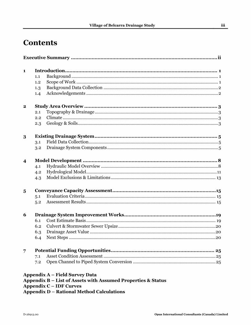
Contents
Executive Summary ................................................................................................... ii
1 Introduction ....................................................................................................... 1 1.1 Background ....................................................................................................................... 1 1.2 Scope of Work ................................................................................................................... 1 1.3 Background Data Collection ............................................................................................. 2
1.4 Acknowledgements ........................................................................................................... 2
2 Study Area Overview .......................................................................................... 3
2.1 Topography & Drainage .................................................................................................... 3 2.2 Climate .............................................................................................................................. 3 2.3 Geology & Soils.................................................................................................................. 3
3 Existing Drainage System ................................................................................... 5 3.1 Field Data Collection ......................................................................................................... 5
3.2 Drainage System Components .......................................................................................... 5
4 Model Development ........................................................................................... 8 4.1 Hydraulic Model Overview ............................................................................................... 8
4.2 Hydrological Model .......................................................................................................... 11 4.3 Model Exclusions & Limitations ..................................................................................... 13
5 Conveyance Capacity Assessment ...................................................................... 15 5.1 Evaluation Criteria .......................................................................................................... 15 5.2 Assessment Results ......................................................................................................... 15
6 Drainage System Improvement Works ..............................................................19
6.1 Cost Estimate Basis ......................................................................................................... 19 6.2 Culvert & Stormwater Sewer Upsize ............................................................................... 20 6.3 Drainage Asset Value ...................................................................................................... 20 6.4 Next Steps ....................................................................................................................... 20
7 Potential Funding Opportunities ...................................................................... 25 7.1 Asset Condition Assessment ........................................................................................... 25 7.2 Open Channel to Piped System Conversion ................................................................... 25
Appendix A – Field Survey Data
Appendix B – List of Assets with Assumed Properties & Status
Appendix C – IDF Curves
Appendix D – Rational Method Calculations
Village of Belcarra Drainage Study iv
D-26913.00 Opus International Consultants (Canada) Limited
List of Figures
Figure 2-1 – Study Area Overview ............................................................................................................ 4 Figure 3-1 – Existing Drainage System ...................................................................................................... 7 Figure 4-1 – Modelled Drainage System ................................................................................................... 9
Figure 5-1 –Capacity Assessment – 5-Year Storm with Climate Change ................................................ 17 Figure 5-2 –Capacity Assessment – 100-Year Storm with Climate Change ........................................... 18 Figure 6-1 – Stormwater Sewer & Culvert Upsizing Requirement ......................................................... 22
List of Tables
Table 1-1 – Data Collection Summary....................................................................................................... 2 Table 4-1 – Summary of Model Elements ................................................................................................ 8 Table 4-2 – Range of Design Rainfall Volumes ....................................................................................... 13 Table 6-1 – Unit Costs for Culvert & Stormwater Sewer Replacement (2017 Canadian Dollars) ........... 19 Table 6-2 – Drainage Asset Value – Replacement Cost ......................................................................... 23 Table 7-1 – Grant/Funding Description ................................................................................................. 26

Village of Belcarra Drainage Study 3
D-26913.00 Opus International Consultants (Canada) Limited
2 Study Area Overview
The Village of Belcarra is a municipality in British Columbia (BC) with a population of 643 (2016
Census). It is a member municipality of Metro Vancouver, located on the eastern shore of the Indian
Arm, a side inlet extending north from the Burrard Inlet. An overview of the study area is shown in
Figure 2-1.
2.1 Topography & Drainage
The study area is situated on steep terrains, typical of areas located on the side of a hill/mountain. The
drainage in the study area is provided by way of surface drainage, roadside ditches, culverts, local
creeks, and a limited number of stormwater sewers in the developed areas. The stormwater runoffs in
the study area can be broken down into the following sources/types: developed rural residential lots
(280 of them), the Village Hall, road surfaces, and the forested areas in the uplands (part of the
Belcarra Regional Park) that contribute runoffs to the study area.
Runoffs from the roads and developed lots are captured and conveyed by the network of ditches and
culverts, and stormwater sewers to the numerous outfalls into either Bedwell Bay or Belcarra Bay.
Some parts of the study area (east) discharges to Sasamat Creek, which also conveys water from
Sasamat Lake to Bedwell Bay.
Runoffs originating from the uplands are intercepted by the Village’s road network and local creeks
before being conveyed by the open channel system in the developed areas to the outfalls. Runoffs from
the uplands south of the developed area (Woodhaven) are intercepted by Bedwell Bay Road and Main
Avenue, and Rae Creek. Runoffs from the uplands east of the Coombe area are intercepted mainly by
Belcarra Bay Road and Dutchman Creek.
2.2 Climate
Meteorological data were referenced from the nearest long-term climate station (Port Moody
Glenayre), located in the City of Port Moody, approximately 6 km south of the Village. There is a closer
climate station (Indian Arm Woodlands) to the Village, however its data is limited. The Port Moody
Glenayre climate station’s historical data indicates a total average annual precipitation of just over
163 cm, with approximately 5 cm comprising snow and approximately 158 cm falling as rain. Average
monthly air temperature ranges from approximately 0◦C in January to over 22◦C in July.
2.3 Geology & Soils
According to the BC Soil geodatabase procured from BC Soils Information System, Ministry of
Environment, the Village is underlaid with predominantly “BUNTZEN” soil with some portions of
“STEELHEAD” soil, which are both Sandy Loam in texture. The surrounding forested areas of the
Belcarra Regional Park to the south of the Village and on the west shore of Bedwell Bay consist of
“CANNELL”, “EUNICE”, and “BUNTZEN” soils, which have a texture of Loam, Loamy Sand, and
Sandy Loam, respectively. Overall, the majority of the soils within the study area consist of Sandy
Loam soils which have fair to poor drainage characteristics.

Village of Belcarra Drainage Study 2
D-26913.00 Opus International Consultants (Canada) Limited
• Develop cost estimates for the replacement of the Village’s culverts and stormwater sewers; and,
• Comment and provide recommendations for the process of converting from an open ditch system
to a piped network.
1.3 Background Data Collection
This section lists the existing data collected and reviewed by Opus for developing the Drainage Study.
The information was mainly collected in electronic format, and consists of geospatial data, drawings
and reports of previous relevant studies. The procured data, as summarized in Table 3-1, was used as
background information, model construction, and development of the Drainage Study.
Table 1-1 – Data Collection Summary
Description Data Type Source
Background/Base Map
Village Parcels
CAD files Village Street Centerlines
Village Boundary
0.5 m Elevation Contours
Satellite Imagery and Street Views* Raster/Images Google Earth
Model Development
Culverts, Ditches, Stormwater Sewers, Catch
Basins, Manholes, and Outfalls
Cad Files
PDF Documents Village
BC Soil Information ESRI Geodatabase Ministry of Environment
Village Drainage Asset Inventory PDF Document Village
Reference Documents
Proposed City Works Village of Belcarra BC – HY
Engineering Ltd., January 2015
PDF Document/
Reports Village
Drainage Study and Geotechnical Assessment –
Associated Engineering Services Ltd., March 1984
Village of Belcarra Subdivision and Development
Bylaw No. 492, 2015 *for reference only
1.4 Acknowledgements
Opus acknowledges the support and cooperation of the Village of Belcarra and extends its appreciation
to Bernie Serné, Superintendent of Public Works at the Village, and Ron Beesley, Senior Project
Engineer at HY Engineering for their assistance to the project team at Opus in preparing this report
and completing this project.
The model development and analyses, and report were prepared by Nima Najafi, P.Eng., Fofo Deng Ke
Fan, E.I.T., and Michael Levin, E.I.T., with field services from Brad Geib, C.E.T., AScT., with
supervision and direction from Paramjeet Mankoo, C.Eng.

Village of Belcarra Drainage Study 3
D-26913.00 Opus International Consultants (Canada) Limited
2 Study Area Overview
The Village of Belcarra is a municipality in British Columbia (BC) with a population of 643 (2016
Census). It is a member municipality of Metro Vancouver, located on the eastern shore of the Indian
Arm, a side inlet extending north from the Burrard Inlet. An overview of the study area is shown in
Figure 2-1.
2.1 Topography & Drainage
The study area is situated on steep terrains, typical of areas located on the side of a hill/mountain. The
drainage in the study area is provided by way of surface drainage, roadside ditches, culverts, local
creeks, and a limited number of stormwater sewers in the developed areas. The stormwater runoffs in
the study area can be broken down into the following sources/types: developed rural residential lots
(280 of them), the Village Hall, road surfaces, and the forested areas in the uplands (part of the
Belcarra Regional Park) that contribute runoffs to the study area.
Runoffs from the roads and developed lots are captured and conveyed by the network of ditches and
culverts, and stormwater sewers to the numerous outfalls into either Bedwell Bay or Belcarra Bay.
Some parts of the study area (east) discharges to Sasamat Creek, which also conveys water from
Sasamat Lake to Bedwell Bay.
Runoffs originating from the uplands are intercepted by the Village’s road network and local creeks
before being conveyed by the open channel system in the developed areas to the outfalls. Runoffs from
the uplands south of the developed area (Woodhaven) are intercepted by Bedwell Bay Road and Main
Avenue, and Rae Creek. Runoffs from the uplands east of the Coombe area are intercepted mainly by
Belcarra Bay Road and Dutchman Creek.
2.2 Climate
Meteorological data were referenced from the nearest long-term climate station (Port Moody
Glenayre), located in the City of Port Moody, approximately 6 km south of the Village. There is a closer
climate station (Indian Arm Woodlands) to the Village, however its data is limited. The Port Moody
Glenayre climate station’s historical data indicates a total average annual precipitation of just over
163 mm, with approximately 5 cm comprising snow and approximately 158 mm falling as rain.
Average monthly air temperature ranges from approximately 0◦C in January to over 22◦C in July.
2.3 Geology & Soils
According to the BC Soil geodatabase procured from BC Soils Information System, Ministry of
Environment, the Village is underlaid with predominantly “BUNTZEN” soil with some portions of
“STEELHEAD” soil, which are both Sandy Loam in texture. The surrounding forested areas of the
Belcarra Regional Park to the south of the Village and on the west shore of Bedwell Bay consist of
“CANNELL”, “EUNICE”, and “BUNTZEN” soils, which have a texture of Loam, Loamy Sand, and
Sandy Loam, respectively. Overall, the majority of the soils within the study area consist of Sandy
Loam soils which have fair to poor drainage characteristics.

Windemere Creek
Rae C
reek
Dutchman Creek
0 0.30.15
KILOMETERS
FIGURE 2-1
LEGEND
Municipal Boundaries
Parcels
Contours (5 m)
Major Creeks
Study Area Catchment
STUDY AREA OVERVIEWTHIS DRAWING AND ITS CONTENTS ARE THE PROPERTY OF OPUS INTERNATIONALCONSULTANTS LIMITED. ANY UNAUTHORISED EMPLOYMENT OF REPRODUCTION,IN FULL OR IN PART, IS FORBIDDEN.
OPUS INTERNATIONAL CONSULTANTS (CANADA) LTD.
NORTH VANCOUVER OFFICE#210 - 889 HARBOURSIDE DRIVE
T: (604) 990 4800 F: (604) 990 4805
Path: G:\opus_dk\municipal\269 Village of Belcarra\gis\D-26913 (Drainage Study)\Fig 2-1 Study_Area_Overview.mxd
D-26913.00
NOV 2017
MLAPPROVED BY
PM
PROJECT NO
DATE
PREPARED BY@ TABLOID
SCALEVILLAGE OF BELCARRA
DRAINAGE STUDY 1:12,500
DIS
TR
ICT
OF
NO
RT
H V
AN
CO
UV
ER
VILLAGE OF BELCARRACITY OF PORT MOODY
VIL
LA
GE
OF
BE
LC
AR
RA

Village of Belcarra Drainage Study 5
D-26913.00 Opus International Consultants (Canada) Limited
3 Existing Drainage System
The Village’s drainage network consists mainly of open channel drainage (ditches and culverts) with a
limited number of stormwater sewers. The entire drainage network eventually discharges into Bedwell
Bay and Belcarra Bay through numerous outfalls and creeks.
Figure 3-1 shows an overview of the drainage system components. The following subsections provide
a detailed description of the Village’s existing drainage system based on the background data provided
and the findings from Opus field survey.
3.1 Field Data Collection
Based on Opus’ initial review of the drainage asset inventory provided by the Village at the RFP stage,
141 culverts were identified with the majority of them listing associated size. However, other critical
data, namely the upstream and downstream invert elevations, were not available.
Opus conducted a field survey to determine upstream and downstream invert elevations, size,
material, and headwall/tailwall details (if any) for the critical culverts selected for the survey program.
Culverts prioritized for the field inspection program were determined based on their criticality and
location – larger culverts at the downstream end of the system were given priority to smaller culverts
at the upstream end.
The field survey covered 64 culverts and 32 catch basins located in the study area. The culverts were
field surveyed for location confirmation and invert elevations. The catch basins were field surveyed for
location confirmation and rim elevations. Of the 32 catch basins surveyed, 22 were later surveyed
again to obtain invert elevations by opening the catch basins and measuring depths of all incoming
and outgoing mains. Refer to Appendix A for further details (location and size) of the surveyed assets.
In addition, during the model development stage of the study, we identified a number of locations with
unknown network connectivity. The Village staff conducted a field investigation to confirm these
connectivity questions – refer to Appendix A for more details.
3.2 Drainage System Components
3.2.1 Creeks
The main creeks within the study area include Sasamat Creek, Rae Creek, and Dutchman Creek.
A portion of the Village’s drainage system in the northeast discharges into Sasamat Creek which also
conveys flows from Sasamat Lake to Bedwell Bay. This Sasamat Creek (downstream of Sasamat Lake)
is bounded by Bowser Avenue to the north and Bedwell Bay Road and Watson Road to the south.
There are sections of Sasamat Creek upstream of Sasamat Lake that captures and conveys runoffs from
the uplands south of the study area to Sasamat Lake, these sections of the Sasamat Creek and its
drainage catchments are outside the scope of this study.

Village of Belcarra Drainage Study 6
D-26913.00 Opus International Consultants (Canada) Limited
Rae Creek, which starts in the uplands at the south end of the study area in the Belcarra Regional Park,
conveys runoffs from the uplands, as well as discharges from the ditches along Bedwell Bay Road, to
cross Bedwell Bay Road via a culvert (“BD-75”) to discharge into Bedwell Bay.
Dutchman Creek, which starts in the uplands in the Coombe area, conveys runoffs from the uplands
and discharge into the open channel system at Belcarra Road and Salish Road. The flows are then
conveyed via ditches and culverts to an outfall discharging into Belcarra Bay.
3.2.2 Culverts
According to the Village’s asset inventory and Opus’ site investigation, the total length of culverts is
estimated at 2 km. As per the Village’s asset inventory and Opus’ site investigation, there are
approximately 141 culverts within the Village, ranging in size from 100 mm to 1,200 mm. The majority
of the culverts have been found to be 300 mm and 450 mm in diameter (55% and 18% by total length,
respectively). The culverts in the Village are named with a two-letter prefix, denoting the road it is on,
followed by two numbers.
3.2.3 Stormwater Mains
The stormwater mains receive surface runoff through catch basins. According to the Village’s asset
inventory, the total length of stormwater mains is estimated at 1.1 km. As per the Village’s asset
inventory, there are approximately 65 storm sewers within the Village, ranging in size from 100 mm to
750 mm. The majority of the mains have been found to be 300 mm, 450 mm, and 600 mm in diameter
(18%, 23%, and 25% by total length, respectively).
3.2.4 Ditches
According to the Village’s CAD files, the length of roadside ditches is estimated at approximately 4 km.
Very limited information is available for the ditches and assumptions for their cross-sections had to be
made for the purpose of hydraulic modelling (see Section 4.1.2).
3.2.5 Catch Basins and Inlets
Catch basins and inlets receive the surface runoff from the paved areas and discharge into ditches,
culverts, and stormwater mains. As per the Village’s CAD files, there are approximately 51 catch basins
in the study area.
3.2.6 Outfalls
The Village’s drainage system discharges into Bedwell Bay and Belcarra Bay through outfalls at various
locations. In total, 41 outfalls identified and subsequently modelled in the study area’s drainage model.

Windemere Creek
Rae Creek
Dutchman Creek
0 0.150.075KILOMETERS
FIGURE 3-1
LEGENDCulverts
Stormwater Mains
Ditches
Major Creeks
Parcels
EXISTING DRAINAGE SYSTEMTHIS DRAWING AND ITS CONTENTS ARE THE PROPERTY OF OPUS INTERNATIONALCONSULTANTS LIMITED. ANY UNAUTHORISED EMPLOYMENT OF REPRODUCTION,IN FULL OR IN PART, IS FORBIDDEN.
OPUS INTERNATIONAL CONSULTANTS (CANADA) LTD.
NORTH VANCOUVER OFFICE#210 - 889 HARBOURSIDE DRIVE
T: (604) 990 4800 F: (604) 990 4805
Path: G:\opus_dk\municipal\269 Village of Belcarra\gis\D-26913 (Drainage Study)\Fig 3-1 Existing_Drainage_System.mxd
D-26913.00NOV 2017
MLAPPROVED BY
PM
PROJECT NO
DATE
PREPARED BY@ TABLOID
SCALEVILLAGE OF BELCARRA
DRAINAGE STUDY 1:7,000
Village of Belcarra Drainage Study 8
D-26913.00 Opus International Consultants (Canada) Limited
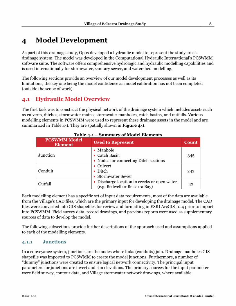
4 Model Development
As part of this drainage study, Opus developed a hydraulic model to represent the study area’s
drainage system. The model was developed in the Computational Hydraulic International’s PCSWMM
software suite. The software offers comprehensive hydrologic and hydraulic modelling capabilities and
is used internationally for stormwater, sanitary sewer, and watershed modelling.
The following sections provide an overview of our model development processes as well as its
limitations, the key one being the model confidence as model calibration has not been completed
(outside the scope of work).
4.1 Hydraulic Model Overview
The first task was to construct the physical network of the drainage system which includes assets such
as culverts, ditches, stormwater mains, stormwater manholes, catch basins, and outfalls. Various
modelling elements in PCSWMM were used to represent these drainage assets in the model and are
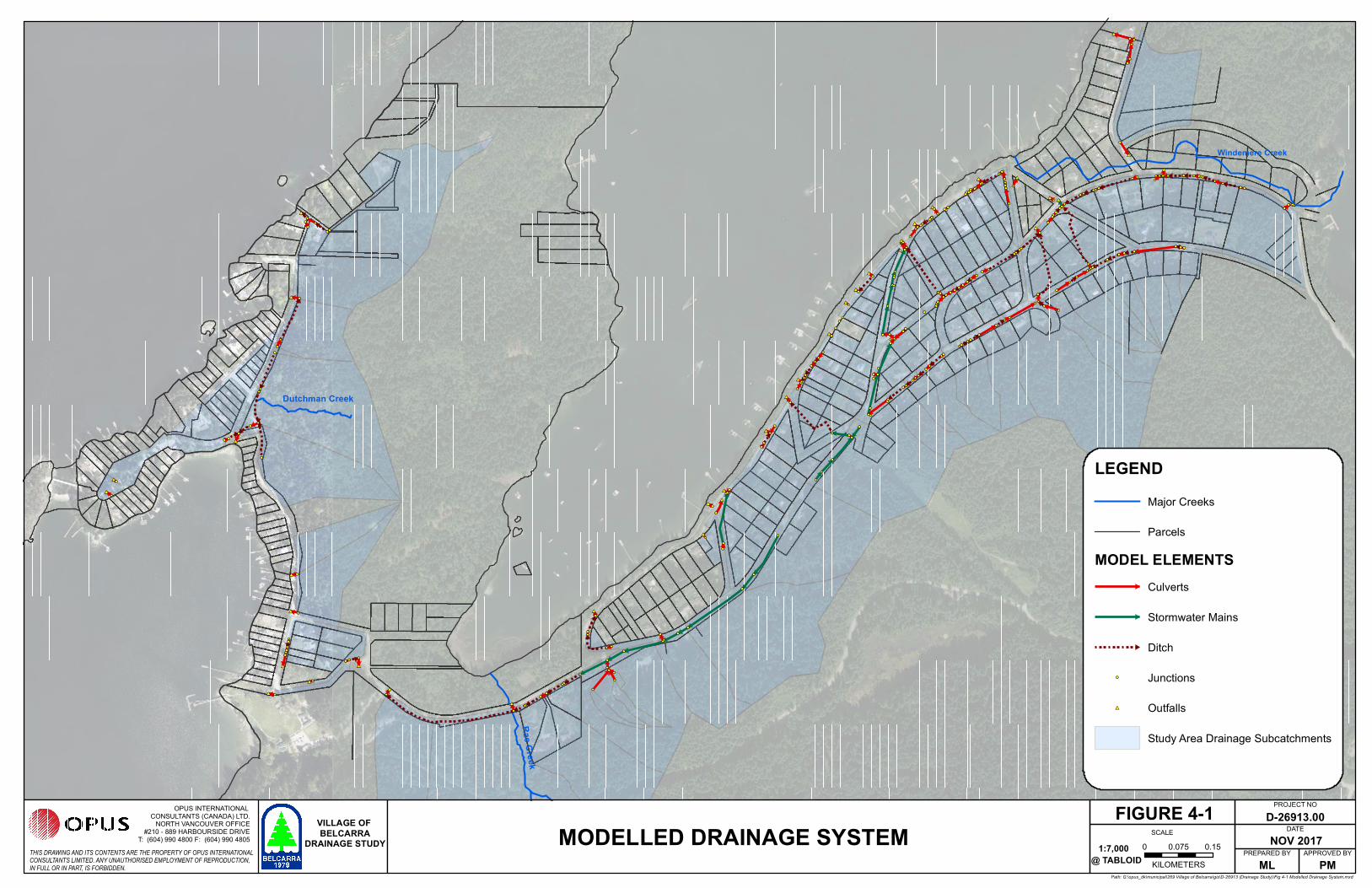
summarized in Table 4-1. They are spatially shown in Figure 4-1.
Table 4-1 – Summary of Model Elements PCSWMM Model
Element Used to Represent Count
Junction • Manhole
• Catch Basin
• Nodes for connecting Ditch sections
345
Conduit • Culvert
• Ditch
• Stormwater Sewer
242
Outfall • Discharge location to creeks or open water
(e.g. Bedwell or Belcarra Bay) 42
Each modelling element has a specific set of input data requirements, most of the data are available
from the Village’s CAD files, which are the primary input for developing the drainage model. The CAD
files were converted into GIS shapefiles for review and formatting in ESRI ArcGIS 10.4 prior to import
into PCSWMM. Field survey data, record drawings, and previous reports were used as supplementary
sources of data to develop the model.
The following subsections provide further descriptions of the approach used and assumptions applied
to each of the modelling elements.
4.1.1 Junctions
In a conveyance system, junctions are the nodes where links (conduits) join. Drainage manholes GIS
shapefile was imported to PCSWMM to create the model junctions. Furthermore, a number of
“dummy” junctions were created to ensure logical network connectivity. The principal input
parameters for junctions are invert and rim elevations. The primary sources for the input parameter
were field survey, contour data, and Village stormwater network drawings, where available.
##
##
##
##
##
##
##
##
##
##
##
##
##
##
##
##
##
####
##
####
##
##
####
##
##
##
##
##
##
##
##
##
##
##
##
##
##
##
Windemere Creek
Rae
Creek
Dutchman Creek
0 0.150.075
KILOMETERS
FIGURE 4-1
LEGEND
Major Creeks
Parcels
MODEL ELEMENTS
Culverts
Stormwater Mains
Ditch
Junctions
## Outfalls
Study Area Drainage Subcatchments
MODELLED DRAINAGE SYSTEMTHIS DRAWING AND ITS CONTENTS ARE THE PROPERTY OF OPUS INTERNATIONALCONSULTANTS LIMITED. ANY UNAUTHORISED EMPLOYMENT OF REPRODUCTION,IN FULL OR IN PART, IS FORBIDDEN.
OPUS INTERNATIONAL CONSULTANTS (CANADA) LTD.
NORTH VANCOUVER OFFICE#210 - 889 HARBOURSIDE DRIVE
T: (604) 990 4800 F: (604) 990 4805
Path: G:\opus_dk\municipal\269 Village of Belcarra\gis\D-26913 (Drainage Study)\Fig 4-1 Modelled Drainage System.mxd
D-26913.00
NOV 2017
MLAPPROVED BY
PM
PROJECT NO
DATE
PREPARED BY@ TABLOID
SCALEVILLAGE OF BELCARRA
DRAINAGE STUDY 1:7,000

Village of Belcarra Drainage Study 10
D-26913.00 Opus International Consultants (Canada) Limited
Opus included a total of 386 junctions (manholes, catch basins, and model connectivity nodes) in the
model, of which 214 junctions (55%) were identified with unknown rim and/or invert elevations. 0.5 m
contour data was used to estimate the rim elevation for junctions with missing rim elevations. The
invert elevations were estimated by assuming a minimum pipe cover of half their diameter. In some
cases, this was adjusted to allow for appropriate pipe slope.
4.1.2 Conduits
Culverts, stormwater mains, and ditches were modelled as conduits in the drainage hydraulic model. A
number of “dummy” conduits were added to the model to ensure logical network connectivity. A total
of 2 km of culverts were modelled. In addition, over 3.7 km of stormwater mains and ditches were
modelled to ensure network connectivity. The principal input parameters for conduits are diameter,
inlet/outlet elevations, length, and Manning’s roughness coefficient (n).
Approximately 11% of the modelled culverts and approximately 40% of the modelled stormwater
mains were missing diameter information. For these conduits, the immediate upstream or
downstream conduit diameters were applied – smaller diameters were conservatively taken in the case
of size differences upstream and downstream, where applicable.
Refer to Appendix B for a list and a figure of culverts and stormwater sewers with assumed sizes. It
also identifies culverts assumed to be abandoned or replaced with a piped network. We would
recommend Village staff field investigate these assets as a next-step and leverage the available funding
for “Data Collection and Reporting” through the new Federation of Canadian
Municipalities’ (FCM) Municipal Asset Management Program (MAMP) – refer to Section
7.1 for more details.
Approximately 2.4 km of ditches were modelled. However, no drawings or field survey data was
available for open channel cross sections. They were assumed to be trapezoidal based on the design
standards in the Village’s Subdivision and Development Bylaw No. 492, 2015, which also suggests a
maximum depth of 1 m, maximum side slopes of 1.5 H: 1 V, a minimum bottom width of 0.3 m, and a
minimum grade of 0.5% for ditches. These initial parameters were further refined based on available
contour data and Google Earth Pro street views (where available).
Finally, the manning’s roughness coefficient used for pipes (culverts and stormwater mains) is 0.013,
which is the industry average for closed conduits. For ditches, a coefficient of 0.05 is applied as is
typical for natural channels with regular section.
4.1.3 Outfalls
Terminal nodes within the drainage system were modelled as outfalls in the drainage model. They
represent outfall discharges into creeks, rivers, and large waterbodies. The invert elevations and rim
elevations are principal input parameters for outfalls. Note that it was beyond the scope of work to
consider tidal or surcharging influence at the outfall, and as such, a “free” outfall condition is assumed
for all modelled outfalls.

Village of Belcarra Drainage Study 11
D-26913.00 Opus International Consultants (Canada) Limited
4.2 Hydrological Model
Typically, the hydrologic component of the model is responsible for runoff generation and flow routing
from the drainage sub-catchment to the receiving drainage system (culverts, ditches, stormwater
mains). For this Drainage Study, the Rational Method is used for runoff generation with the flow
routing component captured in the time of concentration calculations completed for each sub-
catchment. The runoff is then applied directly to the receiving culvert or ditch or stormwater main.
The following describes our approach to delineating the drainage sub-catchments in the study area as
well as the runoff calculations completed for each of the sub-catchments.
4.2.1 Sub-catchment Delineation
Sub-catchments are hydrologic units of land whose topology and drainage system elements direct
surface runoff to a single discharge point. To achieve higher resolution in the model, the study area
was divided and delineated into numerous sub-catchments based on contour data, location of catch
basins and service lines, Village parcels, and aerial photographs. The rural undeveloped
sub-catchments, whose runoffs flow into the study area’s drainage system, were also delineated and
included in the model. Each of the sub-catchments were assigned a culvert or stormwater sewer that it
discharges to. The sub-catchments are illustrated in Figure 4-1.
4.2.2 Runoff Calculation
Once all the sub-catchments have been delineated and a discharging conduit assigned, the Rational
Method was used to determine their runoff rates. The runoff is then applied directly to the discharging
conduit in the model for hydraulic capacity assessment. The following summarizes our approach to
calculating runoffs. Refer to Appendix D for the complete calculations for each sub-catchment.
According to the Village’s Bylaw, the following Rational Method formula is used:
Q = RAIN, where:
Q = Flow in m3/s; R = Product of runoff coefficient and adjustment factor; A = Drainage area in
hectares; I = Rainfall Intensity in mm/hr; and, N = 0.00278.
Out of the four input parameters, two are readily available (“A” and “N”). For the other two (“R” and
“I”), the following approach was adopted to determine their values for each sub-catchment.
4.2.2.1 Runoff Coefficient (“R”)
Opus reviewed the aerial photograph (Google Maps) of the study area and determined, for each sub-
catchment, the percentage of area that is residential, parks/green area, or roads. By applying the
Bylaw-suggested runoff coefficients and adjustment factors, an area-weighted average “R” was then
determined for each sub-catchment. Refer to Appendix D for the detailed calculation of “R”.
The runoff coefficient “C” is a key component in the application of Rational Method. It is reasonable to
assume that “C” is independent of rainfall intensity or volume in impervious areas, such as streets,
Village of Belcarra Drainage Study 12
D-26913.00 Opus International Consultants (Canada) Limited
rooftops and parking lots. For pervious areas, the fraction of runoff varies with rainfall intensity and
the accumulated volume of rainfall. Thus, it is crucial in the application of the Rational Method to
select a runoff coefficient that is appropriate for the storm, soil and land use conditions. For the
purpose of this study, a weighted “C” factor was estimated using the Village Bylaw recommendation for
the various lands uses, which are eventually multiplied by the adjustment factors, also proposed by the
Bylaw. The percentages of different land use types in each sub-catchment were determined through a
high-level visual review of the current (2017) ortho photos and did not involve field reviews or
delineation of land use polygons. Assessment of the future land use conditions are beyond the scope of
this study.
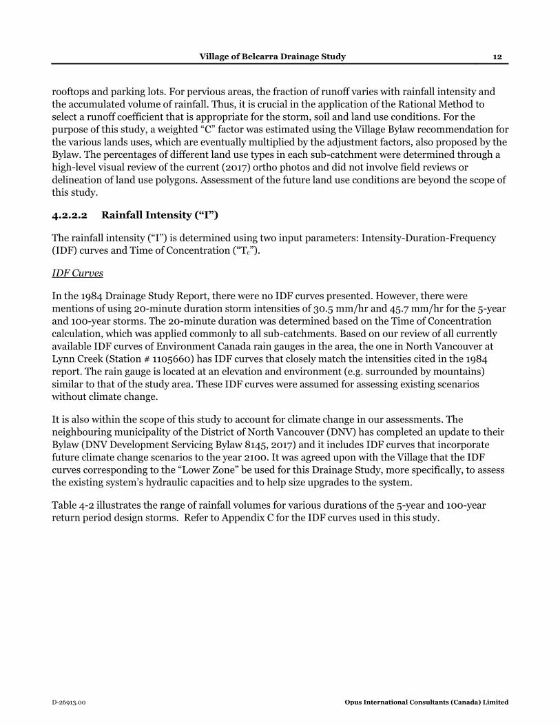
4.2.2.2 Rainfall Intensity (“I”)
The rainfall intensity (“I”) is determined using two input parameters: Intensity-Duration-Frequency
(IDF) curves and Time of Concentration (“Tc”).
IDF Curves
In the 1984 Drainage Study Report, there were no IDF curves presented. However, there were
mentions of using 20-minute duration storm intensities of 30.5 mm/hr and 45.7 mm/hr for the 5-year
and 100-year storms. The 20-minute duration was determined based on the Time of Concentration
calculation, which was applied commonly to all sub-catchments. Based on our review of all currently
available IDF curves of Environment Canada rain gauges in the area, the one in North Vancouver at
Lynn Creek (Station # 1105660) has IDF curves that closely match the intensities cited in the 1984
report. The rain gauge is located at an elevation and environment (e.g. surrounded by mountains)
similar to that of the study area. These IDF curves were assumed for assessing existing scenarios
without climate change.
It is also within the scope of this study to account for climate change in our assessments. The
neighbouring municipality of the District of North Vancouver (DNV) has completed an update to their
Bylaw (DNV Development Servicing Bylaw 8145, 2017) and it includes IDF curves that incorporate
future climate change scenarios to the year 2100. It was agreed upon with the Village that the IDF
curves corresponding to the “Lower Zone” be used for this Drainage Study, more specifically, to assess
the existing system’s hydraulic capacities and to help size upgrades to the system.
Table 4-2 illustrates the range of rainfall volumes for various durations of the 5-year and 100-year
return period design storms. Refer to Appendix C for the IDF curves used in this study.

Village of Belcarra Drainage Study 13
D-26913.00 Opus International Consultants (Canada) Limited
Table 4-2 – Range of Design Rainfall Volumes
Duration
5-Year (mm) 100-Year (mm)
Existing Climate Change
Existing Climate Change
15-min 8.3 12.1 12.5 22.3 30-min 11.9 15.9 17.7 28.5 1-hour 17.6 21.0 26.0 36.0 24-hour 156.5 146.4 255.8 234.6
Time of Concentration
In order to calculate the Time of Concentration (Tc) parameter, as per the Village Bylaw, the sub-
catchment slope, length, concentration coefficient, and friction factor need to be determined. The
slope was estimated using the Digital Elevation Model (DEM), available through Natural Resources
Canada1. The length was estimated by tracing the drainage flow path from the furthest point in the
sub-catchment to the discharge point. The concentration coefficient and friction factor were estimated
via review of the ortho photos and factoring the length of overland flow paths, ditches, stormwater
sewers, percentage of paved and natural areas.
All the above parameters are summarized in Appendix D.
4.3 Model Exclusions & Limitations
4.3.1 Model Exclusion
As the primary focus of the Drainage Study was to assess the hydraulic capacity of the Village’s culverts
and stormwater sewers, the ditches were modelled with assumed parameters to provide model
network connectivity. In addition, it was outside the scope of the Drainage Study to model the
conveyance of the major system including overland flow, road drainage, and creeks. Finally, tidal
impacts of Bedwell Bay and Belcarra Bay on the study area’s outfalls have not been considered.
4.3.2 Model Confidence
It was beyond the scope of this study to calibrate the model to observe flows. In addition, cross
sections of the ditches were not surveyed, instead they were modelled based on contour data, aerial
imagery review, and using typical geometry as per the Village’s subdivision bylaw. This limits the
model’s ability to capture the actual cross section of the ditches, and will only provide an
approximation to capacity. All the above have limited the use of this model to planning level studies
and conceptual recommendations only. Considering that the Village has no recorded hydraulic and
flooding issues in the past, the current model is adequate.
1 http://open.canada.ca/data/en/dataset/7f245e4d-76c2-4caa-951a-45d1d2051333

Village of Belcarra Drainage Study 14
D-26913.00 Opus International Consultants (Canada) Limited
4.3.3 Hydrology Limitations
The Village’s Bylaw stipulates using the Rational Method for tributary areas up to 4.0 hectares. Over
95% of the catchments delineated in the study area are less than 4.0 hectares and as such, the Rational
Method was used in this study. One key characteristic of the Rational Method is that the rate of runoff
resulting from any rainfall intensity is a maximum when the rainfall intensity lasts as long or longer
than the time of concentration. Specifically, the entire drainage area does not contribute to the peak
discharge until the time of concentration has elapsed. This assumption limits the size of the drainage
basin that can be evaluated by this method and will typically result in overestimated peak flows. This is
adequate for this study in-lieu of flow monitoring data to compare model predictions against.
Village of Belcarra Drainage Study 15
D-26913.00 Opus International Consultants (Canada) Limited
5 Conveyance Capacity Assessment
This section presents the findings from our conveyance capacity assessment, identifying those culverts
and stormwater sewers that are deficient under the existing and climate change scenarios. We have
also outlined the evaluation criteria used to assess the culverts and stormwater sewers in the study
area.
5.1 Evaluation Criteria
As per the Village Bylaw, the minor system and the major system are to be designed to convey 5-year
and 100-year flows, respectively. The minor system includes the stormwater sewers and the driveway
culverts while the major system includes the road culverts, ditches, and the roads.
Although a detailed assessment of the major system is beyond the scope of this drainage study,
especially the review of ditch capacities and major flow routes, we have included critical road culverts
in our capacity assessments. These culverts are typically located downhill and are outfalls to the
system. The purpose of reviewing these critical culverts is to ensure that they are adequately sized to
convey major system flows out of the system into the bays or creeks.
In general, a culvert or a stormwater sewer’s inadequate capacity are predicted in the hydraulic model
in the form of a flow restriction that causes flooding in the upstream system.
5.2 Assessment Results
The drainage system in the study area was assessed under three flow conditions:
• 5-year Storm without Climate Change
• 5-year Storm with Climate Change
• 100-year Storm with Climate Change
5.2.1 5-Year Storm – Validation Scenario
According to Village staff, the study area has not experienced significant flooding or ponding issues,
which is indicative of adequate conveyance capacity in the existing drainage system for rainfall events
up to the “minor” system’s design criteria of 5-year return period flows. In lieu of measured flow data
and model calibration, Opus used the above observation as anecdotal information to validate the
model. The hydraulic model is not predicting flooding in the study area under the 5-year storm event.
5.2.2 5-Year Storm with Climate Change – Assessment Scenario
Under the 5-year design flows with climate change, the model predicts a total of six (6) flooding
locations in the study area as shown in Figure 5-1. Three out of the six flooding occurrences are caused
directly by inadequate downstream culvert capacities, namely “BD-76”, “BD-01A”, and “TU-02”. The
other flooding occurrences are caused by the inadequate capacities in stormwater sewers along Kelly
Road.

Village of Belcarra Drainage Study 16
D-26913.00 Opus International Consultants (Canada) Limited
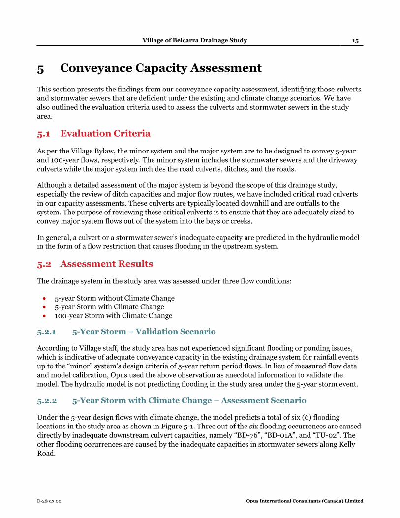
5.2.3 100-Year Storm with Climate Change – Assessment Scenario
Under the 100-year design flows with climate change, the model predicts a total of 24 flooding
occurrences in the study area as shown in Figure 5-2. The majority of the flooding is caused by the
insufficient capacity in the minor system (i.e. driveway culverts and stormwater sewers) to convey the
100-year flows (i.e. major system flows).

##
##
##
##
##
##
##
##
##
##
##
##
##
##
##
##
##
####
##
####
##
##
####
##
##
##
##
##
##
##
##
##
##
##
##
##
##
##
!!!!
!!
!!
!!
!!22 L/s
79 L/s
17 L/s
22 L/s87 L/s
272 L/s
Windemere Creek
Rae Creek
Dutchman Creek
0 0.150.075KILOMETERS
FIGURE 5-1
LEGENDMajor Creeks
Parcels
MODEL ELEMENTSCulverts
Stormwater Mains
Ditch
Junctions
## Outfalls
!! Flooded Manholes
Study Area Drainage Subcatchments
CULVERT CAPACITY ASSESSMENT5-YEAR STORM WITH CLIMATE CHANGETHIS DRAWING AND ITS CONTENTS ARE THE PROPERTY OF OPUS INTERNATIONAL
CONSULTANTS LIMITED. ANY UNAUTHORISED EMPLOYMENT OF REPRODUCTION,IN FULL OR IN PART, IS FORBIDDEN.
OPUS INTERNATIONAL CONSULTANTS (CANADA) LTD.
NORTH VANCOUVER OFFICE#210 - 889 HARBOURSIDE DRIVE
T: (604) 990 4800 F: (604) 990 4805
Path: G:\opus_dk\municipal\269 Village of Belcarra\gis\D-26913 (Drainage Study)\Fig 5-1 Culvert Capacity Assessment - 5-Year Storm with Climate Change.mxd
D-26913.00NOV 2017
MLAPPROVED BY
PM
PROJECT NO
DATE
PREPARED BY@ TABLOID
SCALEVILLAGE OF BELCARRA
DRAINAGE STUDY 1:7,000
##
##
##
##
##
##
##
##
##
##
##
##
##
##
##
##
##
####
##
####
##
##
####
##
##
##
##
##
##
##
##
##
##
##
##
##
##
## !!
!!
!!
!!
!!
!!
!!!!
!!
!!
!!
!!
!!
!!
!!
!!
!!!!
!!
!!
!!
!!!!!!
3 L/s
92 L/s
69 L/s
90 L/s
73 L/s27 L/s
67 L/s
18 L/s
75 L/s
34 L/s
25 L/s
378 L/s
313 L/s147 L/s
194 L/s
634 L/s
295 L/s 150 L/s
156 L/s
110 L/s
107 L/s225 L/s
797 L/s
212 L/s
Windemere Creek
Rae Creek
Dutchman Creek
0 0.150.075KILOMETERS
FIGURE 5-2
LEGENDMajor Creeks
Parcels
MODEL ELEMENTSCulverts
Stormwater Mains
Ditch
Junctions
## Outfalls
!! Flooding Manholes
Study Area Drainage Subcatchments
CULVERT CAPACITY ASSESSMENT100-YEAR STORM WITH CLIMATE CHANGETHIS DRAWING AND ITS CONTENTS ARE THE PROPERTY OF OPUS INTERNATIONAL
CONSULTANTS LIMITED. ANY UNAUTHORISED EMPLOYMENT OF REPRODUCTION,IN FULL OR IN PART, IS FORBIDDEN.
OPUS INTERNATIONAL CONSULTANTS (CANADA) LTD.
NORTH VANCOUVER OFFICE#210 - 889 HARBOURSIDE DRIVE
T: (604) 990 4800 F: (604) 990 4805
Path: G:\opus_dk\municipal\269 Village of Belcarra\gis\D-26913 (Drainage Study)\Fig 5-2 Culvert Capacity Assessment - 100-Year Storm with Climate Change.mxd
D-26913.00NOV 2017
MLAPPROVED BY
PM
PROJECT NO
DATE
PREPARED BY@ TABLOID
SCALEVILLAGE OF BELCARRA
DRAINAGE STUDY 1:7,000

Village of Belcarra Drainage Study 19
D-26913.00 Opus International Consultants (Canada) Limited
6 Drainage System Improvement Works
This section summarizes the upsizing requirements for the deficient culverts and stormwater sewers,
as identified in the previous section of this report, to meet design flows under the 5-year and 100-year
climate change scenarios for the minor and major systems, respectively. This section also provides
Class “D” cost estimates for not only the upsizing of deficient pipes, but also the replacement
(same-size) of the other culverts and stormwater sewers with the purpose of incorporating the
estimated value of the Village’s drainage assets into the Tangible Capital Assets (TCA) list.
6.1 Cost Estimate Basis
Table 6-1 below summarizes the unit rates used to provide a Class “D” cost estimate for upsizing and
replacement of culverts and stormwater sewers. Also included is the lump sum costs associated with
headwall and tailwall structures, in the case of culverts.
These unit rates and costs include only supply and installation, road/pavement restoration, and an
allowance of 40% for engineering fees and contingency. They are developed based on relevant past
projects within BC municipalities and Opus’ internal cost database, adjusted to 2017 Canadian dollars.
Table 6-1 – Unit Costs for Culvert & Stormwater Sewer Replacement (2017 Canadian
Dollars)
Item Size Unit Cost ($)
(Culvert/Storm Sewer)
Unit
Culverts /
Stormwater
Sewers
100 $350 / $500 /m
150 $400 / $600 /m
200 $450 / $700 /m
250 $500 / $800 /m
300 $550 / $900 /m
350 $600 / $1,000 /m
375 $650 / $1,050 /m
400 $700 / $1,100 /m
450 $750 / $1,175 /m
500 $800 / $1,275 /m
525 $850 / $1,300 /m
600 $900 / $1,475 /m
700 $950 / $1,700 /m
750 $1,000 / $1,800 /m
900 $1,050 / $2,000 /m
1,200 $1,100 / $2,650 /m
Headwall and Road Restoration
$20,000 Lump Sum

Village of Belcarra Drainage Study 20
D-26913.00 Opus International Consultants (Canada) Limited
The reader should note that the above unit rates are Class “D” cost estimates adequate for budgetary
planning only. A more accurate cost estimate will require site investigation and be determined on a
case-by-case basis, which is outside the scope of this Drainage Study.
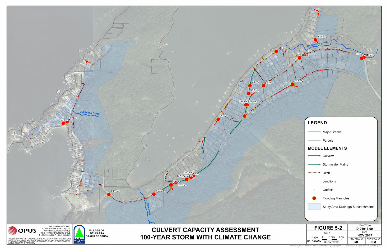
6.2 Culvert & Stormwater Sewer Upsize
We are recommending a total of nine (9) culverts (approximately 134 metres) and 265 m of
stormwater sewers for upsizing. The estimated cost (Class ‘D’) for such improvement works is
$499,300 (2017 Canadian dollar). Of which, $187,400 is attributed to the upsizing of culverts and
$311.900 to the upsizing of stormwater sewers.
Most of the culverts requiring upsizing are part of the major system and are sized for the 100-year
flows. They are situated at outfalls to the system, discharging directly to either the Belcarra/Bedwell
Bays, or the Sasamat Lake. The stormwater sewers requiring upsizing are situated along Kelly Road
and are part of the minor system, they are sized for the 5-year return period storm. Their locations and
recommended sizes are shown in Figure 6-1.
6.3 Drainage Asset Value
The review of pipe age, condition, remaining useful life, and the development of a replacement
schedule for the existing culverts and stormwater sewers are outside the scope of this Drainage Study.
However, it is the intent of this study to estimate the replacement value of the Village’s drainage asset
such that it can be incorporated into the TCA list.
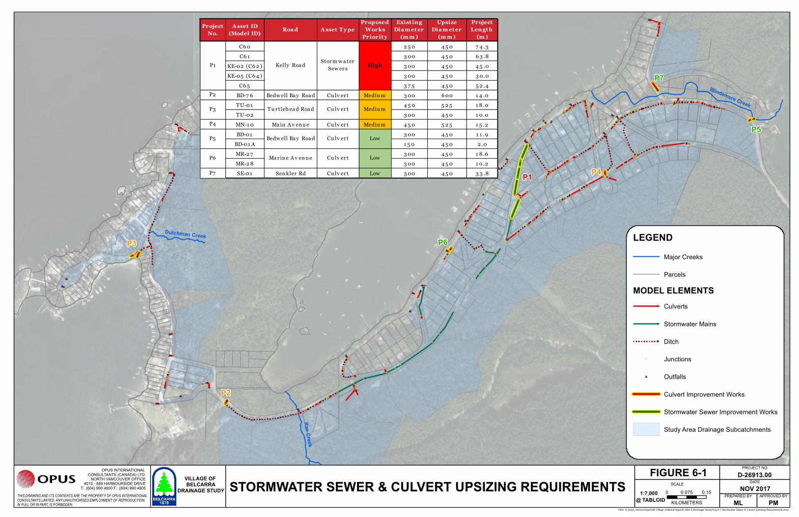
Table 6-2 provides an inventory of the study area’s drainage assets, namely the culverts and
stormwater sewers, and their respective replacement cost estimates. For culverts with known
upstream or downstream headwall material, their replacements include the costs associated with a
new head/tailwall as well.
Based on our unit costs described in Section 6.1, the total value of the drainage assets is estimated at
$4.5 million (2017 Canadian dollar). Of which, $2.1 million is attributed to culverts and $2.4 million
to stormwater sewers. These include the costs of the necessary upsizing of culverts and stormwater
sewers (i.e. the improvement works). For those assets not requiring upsizing, the cost of replacement
(same-size) was considered.
6.4 Next Steps
Typically, for modelling studies, we would recommend clients to improve the confidence of the model
by way of flow monitoring and model calibration. However, considering that the Village is not
experiencing significant flooding issues, these modelling improvements may not be a priority.
Opus included a total of 386 junctions (manholes, catch basins, and model connectivity nodes) in the
model, of which 214 junctions (55%) were identified with unknown rim and/or invert elevations.
Approximately 11% of the modelled culverts and approximately 40% of the modelled stormwater
mains were missing diameter information. The Village may wish to, as a next-step, consider
completing data collection for its drainage (and potentially other) assets including its ageing culverts.
There are funds available through the FCM’s Municipal Asset Management Program (see next section

Village of Belcarra Drainage Study 21
D-26913.00 Opus International Consultants (Canada) Limited
for more details) for “Data Collection and Reporting”. The intent of this exercise is to enhance the
Village’s asset management practices.
With a better understanding of its assets, the Village can better prioritize investment decisions such as
the design and implementation of a piped network to replace the open channel system in Belcarra.
Refer to the next section for relevant funding availabilities.
##
##
##
##
##
##
##
##
##
##
##
##
##
##
##
##
##
####
##
####
##
##
####
##
##
##
##
##
##
##
##
##
##
##
##
##
##
##
Windemere Creek
Rae Creek
Dutchman Creek
0 0.150.075KILOMETERS
FIGURE 6-1
LEGENDMajor Creeks
Parcels
MODEL ELEMENTSCulverts
Stormwater Mains
Ditch
Junctions
## Outfalls
Culvert Improvement Works
Stormwater Sewer Improvement Works
Study Area Drainage Subcatchments
STORMWATER SEWER & CULVERT UPSIZING REQUIREMENTSTHIS DRAWING AND ITS CONTENTS ARE THE PROPERTY OF OPUS INTERNATIONALCONSULTANTS LIMITED. ANY UNAUTHORISED EMPLOYMENT OF REPRODUCTION,IN FULL OR IN PART, IS FORBIDDEN.
OPUS INTERNATIONAL CONSULTANTS (CANADA) LTD.
NORTH VANCOUVER OFFICE#210 - 889 HARBOURSIDE DRIVE
T: (604) 990 4800 F: (604) 990 4805
Path: G:\opus_dk\municipal\269 Village of Belcarra\gis\D-26913 (Drainage Study)\Fig 6-1 Stormwater Sewer & Culvert Upsizing Requirements.mxd
D-26913.00NOV 2017
MLAPPROVED BY
PM
PROJECT NO
DATE
PREPARED BY@ TABLOID
SCALEVILLAGE OF BELCARRA
DRAINAGE STUDY 1:7,000
P2
Project No.
A sset ID (Model ID) Roa d A sset T y pe
Proposed Works
Priorit y
Exist ing Dia m et er
(m m )
Upsize Dia m et er
(m m )
Project Lengt h
(m )C6 0 2 5 0 4 5 0 7 4 .3C6 1 3 00 4 5 0 6 3 .8
KE-02 (C6 2 ) 3 00 4 5 0 4 5 .0KE-05 (C6 4 ) 3 00 4 5 0 3 0.0
C6 5 3 7 5 4 5 0 5 2 .4P2 BD-7 6 Bedw ell Ba y Roa d Cu lv er t Mediu m 3 00 6 00 1 4 .0
TU-01 4 5 0 5 2 5 1 8 .0TU-02 3 00 4 5 0 1 0.0
P4 MN-1 0 Ma in A v en u e Cu lv er t Mediu m 4 5 0 5 2 5 1 5 .2BD-01 3 00 4 5 0 1 1 .9
BD-01 A 1 5 0 4 5 0 2 .0MR-2 7 3 00 4 5 0 1 8 .6MR-2 8 3 00 4 5 0 1 0.2
P7 SE-01 Sen kler Rd Cu lv er t Low 3 00 4 5 0 3 3 .8
P1 Kelly Roa d Stor m w a ter Sew er s High
P3 Tu r t leh ea d Roa d Cu lv er t Mediu m
P5 Bedw ell Ba y Roa d Cu lv er t Low
P6 Ma r in e A v en u e Cu lv er t Low
P3
P4P1
P5
P6
P7
Road Name Pipe ID Asset Type Diameter (mm) Pipe MaterialGIS/Modelled
Length (m)Upstream Headwall
Material
Downstream Headwall Material
Proposed Works PriorityProposed
Upsize Diameter
Improvement/ Replacement
CostBD-01 Culvert 300 Unknown 11.9 Rock Cement Bag Low 450 $28,910BD-01A Culvert 150 Unknown 2.0 Wood Wood Low 450 $21,510BD-02 Culvert 200 Unknown 8.0 None None $3,582BD-03 Culvert 450 Unknown 18.6 None Rock $33,973BD-04 Culvert 450 Unknown 3.7 Cement Bag Cement Bag $22,745BD-05 Culvert 450 Unknown 11.0 None Cement Bag $28,270BD-05A Culvert 450 Unknown 1.9 Cement Bag Cement Bag $21,455BD-06 Culvert 450 Unknown 11.5 None N/A $8,610BD-07 Culvert 600 Unknown 14.2 N/A Cast Concrete $32,745BD-08 Culvert 300 Unknown 8.0 None None $4,404BD-09 Culvert 450 Unknown 14.0 Rock Rock $30,466BD-10 Culvert 300 Unknown 10.4 Cast Concrete Cast Concrete $25,742BD-11 Culvert 300 Unknown 7.5 Rock Rock $24,145BD-11A Culvert 300 Concrete 1.5 None None $825BD-12 Culvert 300 Unknown 7.5 Cast Concrete Cast Concrete $24,133BD-13 Culvert 600 Concrete 7.9 Cement Bag N/A $27,124BD-14 Culvert 750 Unknown 2.8 Cement Bag N/A $22,793BD-16 Culvert 600 Unknown 6.1 Cement Bag N/A $25,489BD-17 Culvert 300 Unknown 8.4 None None $4,617BD-18 Culvert 300 Unknown 15.7 None Cement Bag $28,621BD-19 Culvert 900 Unknown 13.6 Unknown Rock $34,252BD-20 Culvert 300 Unknown 5.0 None None $2,771BD-21 Culvert 300 Concrete 4.6 None None $2,514BD-22 Culvert 300 Concrete 15.2 None None $8,333BD-23 Culvert 300 Concrete 13.8 None None $7,563BD-24 Culvert 300 Concrete 22.5 Wood None $32,375BD-25 Culvert 300 Concrete 21.6 None None $11,865BD-26 Culvert 300 Concrete 7.7 None None $4,228BD-27 Culvert 300 Unknown 10.5 Plastic Cast Concrete $25,782BD-28 Culvert 250 PVC 16.2 None None $8,100BD-29 Culvert 100 PVC 4.6 None None $1,600BD-30 Culvert 300 Concrete 7.9 None None $4,340BD-31 Culvert 300 Concrete 25.3 None None $13,901BD-32 Culvert 500 Concrete 14.3 Cast Concrete Rock $31,474BD-33 Culvert 450 PVC 13.2 None None $9,867BD-34 Culvert 250 Unknown 9.1 None None $4,540BD-37 Culvert 450 Concrete 7.6 None None $5,731BD-58 Culvert 150 PVC 3.2 None None $1,271BD-59 Culvert 200 PVC 16.5 None None $7,425BD-64 Culvert 300 Concrete 16.0 None None $8,800BD-65 Culvert 350 Galvanized Pipe 7.0 None None $4,200BD-66 Culvert 250 Concrete 12.0 None None $6,000BD-67 Culvert 250 Concrete 25.0 None None $12,500BD-68 Culvert 300 Concrete 55.0 None None $30,250BD-70 Culvert 600 Concrete 4.5 Cast Concrete Cast Concrete $24,050BD-71 Culvert 600 Concrete 14.9 Cement Bag Cement Bag $33,410BD-74 Culvert 600 Concrete 2.4 Cement Bag Cement Bag $22,160BD-75 Culvert 1200 Concrete 16.8 Cast Concrete Rock $38,436BD-76 Culvert 300 Unknown 14.0 PVC? Cast Concrete Medium 600 $32,618BD-15 Stormwater Sewer 750 Unknown 16.0 N/A N/A $28,800BD-35 Stormwater Sewer 300 Unknown 26.0 None None $23,400BD-36 Stormwater Sewer 300 Concrete 29.0 None None $26,100BD-38 Stormwater Sewer 450 Concrete 21.0 None None $24,675BD-39 Stormwater Sewer 450 Concrete 9.0 None None $10,575BD-40 Stormwater Sewer 450 Concrete 33.0 None None $38,775BD-41 Stormwater Sewer 300 Concrete 27.0 None None $24,300BD-42 Stormwater Sewer 300 Concrete 12.0 None None $10,800BD-43 Stormwater Sewer 150 PVC 22.0 None None $13,200BD-46 Stormwater Sewer 600 Unknown 39.0 None None $57,525BD-45 Stormwater Sewer 600 Unknown 44.0 None None $64,900BD-44 Stormwater Sewer 600 PVC 23.0 None None $33,925BD-47 Stormwater Sewer 600 Concrete 40.0 None None $59,000BD-48 Stormwater Sewer 150 PVC 0.5 None None $288BD-49 Stormwater Sewer 600 Concrete 52.0 None None $76,700BD-50 Stormwater Sewer 150 PVC 1.0 None None $600BD-51 Stormwater Sewer 600 Concrete 57.0 None None $84,075BD-52 Stormwater Sewer 150 PVC 0.5 None None $270BD-53 Stormwater Sewer 150 PVC 1.0 None None $600BD-55 Stormwater Sewer 300 Concrete 12.0 None None $10,800BD-54 Stormwater Sewer 600 Concrete 24.0 None None $35,400BD-61 Stormwater Sewer 450 Concrete 18.0 None None $21,150BD-57 Stormwater Sewer 600 Concrete-PVC? 37.0 None None $54,575BD-56 Stormwater Sewer 100 PVC 15.0 None None $7,500BD-63 Stormwater Sewer 450 Concrete 71.0 None None $83,425BD-60 Stormwater Sewer 300 Galvanized Pipe 19.0 None None $17,100BD-62 Stormwater Sewer 150 PVC 12.0 None None $7,200BD-69 Stormwater Sewer 450 CPP 52.0 Unknown Unknown $61,100BD-72 Stormwater Sewer 300 Concrete 6.0 None None $5,400BD-73 Stormwater Sewer 200 PVC 6.0 None None $4,200C59 Stormwater Sewer 300 - 90.6 - - $81,498C60 Stormwater Sewer 250 - 74.3 - - High 450 $87,253C69 Stormwater Sewer 600 - 40.5 - - $59,776C75 Stormwater Sewer 450 - 41.7 - - $48,994BL-01 Culvert 450 Concrete 24.4 Cement Bag Unknown $38,287BL-03 Culvert 300 Unknown 7.3 Cement Bag Cement Bag $24,021BL-04 Culvert 300 Concrete 6.4 Wood Wood $23,509BL-05 Culvert 450 Concrete 16.8 Steel Cage None $32,573BL-06 Culvert 300 Concrete 12.8 Unknown Unknown $7,040BL-13 Culvert 600 Metal 18.4 Unknown Unknown $16,582BL-14C Culvert 600 DNE 18.3 DNE DNE $16,457BL-18 Culvert 250 Unknown 17.4 Unknown Unknown $8,718BL-2 Culvert 350 DNE 4.0 DNE DNE $2,384BL-07 Stormwater Sewer 300 Concrete 10.0 Unknown Unknown $9,000BL-08 Stormwater Sewer 450 CPP 52.0 Unknown Unknown $61,100BL-09 Stormwater Sewer 100 PVC 24.0 Unknown Unknown $12,000BL-10 Stormwater Sewer 150 Big-O 30.0 Unknown Unknown $18,000BL-11 Stormwater Sewer 300 Concrete 29.0 Unknown Unknown $26,100BL-12 Stormwater Sewer 300 Concrete 38.0 Unknown Unknown $34,200BL-14P Stormwater Sewer 600 DNE 12.0 DNE DNE $17,700BL-15 Stormwater Sewer 500 Metal 22.0 None None $28,050BL-16 Stormwater Sewer 450 Metal 15.0 None None $17,625BL-17 Stormwater Sewer 300 Concrete 6.0 Dirt Dirt $5,400
Bostock Rd BS-01 Stormwater Sewer 450 Galvanized Pipe 38.0 None None $44,650CO-01 Culvert 600 DNE 12.4 DNE DNE $11,187CO-02 Culvert 600 DNE 20.4 DNE DNE $18,360CO-03 Culvert 600 DNE 5.7 DNE DNE $5,114CO-04 Stormwater Sewer 600 DNE 16.0 DNE DNE $23,600CO-05 Stormwater Sewer 600 DNE 25.0 DNE DNE $36,875CO-06 Stormwater Sewer 600 DNE 52.0 DNE DNE $76,700CO-07 Stormwater Sewer 600 DNE 20.0 DNE DNE $29,500CO-08 Stormwater Sewer 600 DNE 11.0 DNE DNE $16,225CO-09 Stormwater Sewer 600 DNE 14.0 DNE DNE $20,650KE-01 Culvert 700 CPP 14.8 None None $14,043KE-04 Culvert 100 Unknown 3.8 None None $1,320KE-06 Culvert 100 Unknown 4.0 None None $1,415KE-03 Stormwater Sewer 600 Unknown 15.0 None None $22,125KE-02 Stormwater Sewer 300 Perforated Pipe 45.0 None None High 450 $52,875KE-05 Stormwater Sewer 300 Perforated Pipe 30.0 None None High 450 $35,250C61 Stormwater Sewer 300 - 63.8 - - High 450 $74,997C65 Stormwater Sewer 375 - 52.4 - - High 450 $61,523MD-01 Culvert 400 Wood 17.4 Unknown Unknown $12,159MD-02 Culvert 300 Concrete 8.2 Rock Rock $24,510MD-03 Culvert 300 Concrete 7.6 Unknown Unknown $4,191MD-04 Culvert 300 Concrete 14.3 Unknown Unknown $7,865MD-05 Stormwater Sewer 400 Wood 25.0 Unknown Unknown $27,500MD-06 Stormwater Sewer 400 Concrete 30.0 Unknown Unknown $33,000
Table 6-2 - Drainage Asset Value - Replacement Cost
Bedwell Bay Rd
Belcarra Bay Rd
Coombe Ln
Kelly Rd
Madison Rd

Road Name Pipe ID Asset Type Diameter (mm) Pipe MaterialGIS/Modelled
Length (m)Upstream Headwall
Material
Downstream Headwall Material
Proposed Works PriorityProposed
Upsize Diameter
Improvement/ Replacement
Cost
Table 6-2 - Drainage Asset Value - Replacement Cost
MN-01 Culvert 300 Unknown 7.5 None None $4,129MN-02 Culvert 300 Unknown 91.9 None None $50,554MN-03 Culvert 300 Unknown 12.3 Cast Concrete Cast Concrete $26,773MN-04 Culvert 300 Unknown 2.1 Cement Bag Cement Bag $21,164MN-05 Culvert 450 Unknown 3.0 Cement Bag Cement Bag $22,228MN-06 Culvert 750 Unknown 11.4 N/A Cement Bag $31,350MN-07 Culvert 300 Unknown 5.5 Cement Bag Cement Bag $23,033MN-08 Culvert 300 Unknown 27.0 None None $14,869MN-09 Culvert 300 Unknown 33.8 None None $18,590MN-10 Culvert 450 CSP 15.2 None None Medium 525 $13,708MN-11 Culvert 450 Unknown 64.0 Rock Cast Concrete $68,007MN-12 Culvert 450 Unknown 12.6 Rock Rock $29,433MN-13 Culvert 300 Unknown 42.4 Rock Rock $43,341MN-14 Culvert 300 Unknown 6.9 None None $3,771MN-15 Culvert 300 Unknown 5.5 None None $3,028MN-16 Culvert 300 Unknown 5.4 Cement Bag Cement Bag $22,963MN-17 Culvert 300 Unknown 10.8 None None $5,952MN-18 Culvert 300 Unknown 15.7 None None $8,626MN-19 Culvert 300 Unknown 6.9 None None $3,809MN-20 Culvert 450 Unknown 54.7 Cast Concrete N/A $61,028MR-01 Culvert 300 Concrete 2.9 None None $1,602MR-02 Culvert 300 Concrete 2.4 None None $1,320MR-03 Culvert 375 Concrete 11.7 Cast Concrete (2.1m) None $27,600MR-04 Culvert 300 Unknown 18.3 N/A N/A $10,046MR-05 Culvert 300 Concrete 11.0 None None $6,034MR-06 Culvert 300 Concrete 8.0 None None $4,400MR-07 Culvert 300 Concrete 7.0 None None $3,850MR-08 Culvert 300 Concrete 13.4 None None $7,348MR-09 Culvert 300 Galvanized Metal 5.8 None None $3,191MR-10 Culvert 300 Concrete 5.0 None None $2,750MR-11 Culvert 300 Concrete 4.6 None None $2,519MR-12 Culvert 300 Concrete 10.1 None None $5,554MR-13 Culvert 300 Concrete 20.6 None None $11,306MR-14 Culvert 100 PVC 5.2 None None $1,811MR-15 Culvert 520 Unknown 16.0 N/A N/A $13,564MR-16 Culvert 520 Concrete 18.6 None None $15,813MR-17 Culvert 300 Unknown 10.7 None None $5,880MR-18 Culvert 300 Concrete 7.8 None None $4,315MR-19 Culvert 300 Unknown 8.8 None None $4,865MR-20 Culvert 300 Concrete 6.9 None None $3,788MR-21 Culvert 300 Unknown 16.0 None None $8,792MR-22 Culvert 300 Unknown 12.4 None None $6,793MR-23 Culvert 300 Unknown 7.4 None None $4,090MR-24 Culvert 400 Unknown 9.0 None None $6,290MR-25 Culvert 300 Unknown 15.9 None None $8,767MR-26 Culvert 450 Unknown 15.0 None None $11,258MR-27 Culvert 300 Unknown 18.6 None None Low 450 $13,935MR-28 Culvert 300 Unknown 10.2 None None Low 450 $7,668MR-29 Culvert 300 Unknown 10.0 None None $5,493MR-30 Culvert 300 Unknown 9.0 None None $4,940MR-31 Culvert 450 Unknown 8.7 None None $6,557MR-32 Culvert 250 Unknown 31.7 None None $15,840MR-33 Culvert 450 Unknown 11.0 None None $8,266MR-34 Culvert 150 Unknown 8.5 None None $3,393MR-36 Culvert 300 Unknown 11.2 None None $6,169MR-35 Stormwater Sewer 300 Unknown 13.0 None None $11,700RO-02 Stormwater Sewer 300 Concrete 20.0 None None $18,000RO-01 Stormwater Sewer 300 Concrete 5.0 None None $4,500RO-04 Stormwater Sewer 300 PVC 56.0 None None $50,400RO-03 Stormwater Sewer 300 Concrete 13.0 None None $11,700SA-01 Stormwater Sewer 300 0 60.0 N/A N/A $54,000SA-03 Stormwater Sewer 300 PVC? 41.0 None None $36,900SE-01 Culvert 300 Concrete 33.8 Cement Bag None Low 450 $45,363SE-02 Culvert 300 PVC 10.4 Unknown N/A $5,746SE-03 Culvert 300 Unknown 31.9 N/A N/A $17,545SE-04 Culvert 300 Concrete 12.9 N/A N/A $7,096SE-05 Culvert 100 PVC 9.4 N/A N/A $3,281SE-06 Culvert 300 Concrete 37.1 N/A Unknown $20,417TT-02 Culvert 200 Unknown 33.8 Unknown Unknown $15,210TT-03 Culvert 300 PVC 47.0 None None $25,835TT-04 Culvert 300 Concrete 16.7 None None $9,191
TT-05 Culvert 450 Concrete 20.1 Rock Headwall Rock Headwall $35,083TT-01 Stormwater Sewer 100 PVC 25.0 N/A Cement Bag $12,500TU-01 Culvert 450 Unknown 18.0 Unknown Unknown Medium 525 $16,200TU-02 Culvert 300 Concrete 10.0 Unknown Unknown Medium 450 $7,500TU-03 Culvert 200 PVC 7.6 Unknown Unknown $3,429TU-04 Culvert 200 PVC 13.7 Unknown Unknown $6,165TU-07 Stormwater Sewer 150 Unknown 7.0 None None $4,200TU-08 Stormwater Sewer 200 Unknown 23.0 None Unknown $16,100TU-05 Stormwater Sewer 150 Unknown 32.0 None None $19,200TU-06 Stormwater Sewer 200 PVC 10.0 None None $7,000WA-02 Culvert 200 CMP 10.3 Unknown None $4,625WA-01 Stormwater Sewer 750 0 55.0 N/A Unknown $99,000WE-01 Culvert 300 Unknown 11.3 None None $6,201WE-02 Culvert 300 Unknown 6.4 None None $3,505YO-01 Culvert 300 Unknown 12.6 N/A N/A $6,914C77 Stormwater Sewer 450 - 113.9 - - $133,778
SUB-TOTAL CULVERT IMPROVEMENT/REPLACEMENT COSTS $2,091,711SUB-TOTAL STORMWATER SEWER IMPROVEMENT/REPLACEMENT COSTS $2,427,503
TOTAL DRAINAGE ASSET VALUE IMPROVEMENT/REPLACEMENT COSTS $4,519,213
Main Ave
Watson Rd
West Rd
Young Rd
Marine Ave
Marine Ave
Robson Rd
Salish Rd
Senkler Rd
Tatlow Rd
Turtlehead Rd

Village of Belcarra Drainage Study 25
D-26913.00 Opus International Consultants (Canada) Limited
7 Potential Funding Opportunities
This section identifies and details a few funding programs, such as the Federation of Canadian
Municipalities’ (FCM) Green Municipal Fund (GMF) and Municipal Asset Management Program
(MAMP), that the Village may wish to consider applying for. These funding programs apply to
feasibility and pilot studies, and capital projects, such as the ones identified in this section. Opus has
assisted many clients in the preparation of their grant funding applications for pilot and capital
projects. We would be delighted to assist the Village in its grant funding applications in future work.
A description of the available funding programs is summarized in Table 7-1.
7.1 Asset Condition Assessment
A comprehensive condition assessment of the Village’s asset can enhance staff’s knowledge of their
assets and better prioritize investment decisions, adhering to industry best practices for asset
management. As a result of the condition assessment, a criticality/risk assessment can be completed,
leading to the development of a prioritized replacement schedule of the assets. This would allow for
better planning to meet short-term and long-term budgetary requirements.
In order to assess asset conditions, field investigations and surveys need to be completed with details
of work recorded/reported. There are funding available for this activity (Data Collection and
Reporting) through FCM’s new MAMP - see Table 7-1 for more details.
7.2 Open Channel to Piped System Conversion
Open channel drainage system in a developed environment requires significant operation and
maintenance effort. If not maintained properly, it could cause capacity issues in the conveyance due to
overgrowth and sediment build-up, as well as social, environmental, and safety issues (e.g. stagnant
water, foul odour, eye sore, ditch bank erosion, and flooding). It is our understanding that the Village
has received requests from residents to convert these open channel systems into buried pipe systems.
For this undertaking, the Village can apply for Green Municipal Fund (GMF) grants, where a
combination of funding and low-interest loans is available, the details of which are summarized in
Table 7-1. Subject to funding approval, Opus can leverage the model to assist the Village in
determining sizing and grading requirements for new stormwater mains in these areas.
Based on our understanding of the Village’s drainage system, we would suggest, as a start, to convert
the open channel systems along Bedwell Bay Road and Main Avenue east of Kelly Road. The open
channel systems along these corridors service a significant portion of the residential areas in the
Village. A preliminary option to be considered could be to route all flows from these corridors west
towards the stormwater sewers on Kelly Road. As they are being slated for upsizing per our drainage
study recommendations, the Village may wish to leverage this opportunity to review and update the
sizing requirements for these sewers to accommodate the increased flows from the abovementioned
option. Opus can leverage the model to assist the Village in determining sizing and grading
requirements for new stormwater mains in these areas.

Village of Belcarra Drainage Study 26
D-26913.00 Opus International Consultants (Canada) Limited
Table 7-1 – Grant/Funding Description
Grant Fund Name
Description Project Examples Funding Breakdown
FCM Green Municipal Fund
Through the Green Municipal Fund (GMF), we provide funding for municipal environmental initiatives that improve air, water, and soil, and reduce greenhouse gas emissions. GMF funding is available to all Canadian municipal governments and their partners for eligible projects.
Stormwater Quality: Feasibility studies, pilot projects and capital projects
Example – a low-impact development project that captures and treats stormwater runoff through permeable pavement and bio-retention planters
Stormwater Management: Feasibility studies, pilot projects and capital projects
Funding for stormwater management feasibility studies about volume of runoff is now offered through FCM's Municipalities for Climate Innovation Program.
Feasibility studies Grants: Up to 50 per cent of eligible costs to a maximum of $175,000.
Pilot projects Grants: Up to 50 per cent of eligible costs to a maximum of $350,000.
Capital projects Offers low-interest loans, with competitive lending rates, usually in combination with grants.
Funding is provided for up to 80 per cent of eligible project costs.
The loan maximum is $5 million, and the grant amount is 15 per cent of the loan.
Applicants with high-ranking projects may be eligible for a loan of up to $10 million, combined with a grant for 15 per cent of the loan amount, to a maximum of $1.5 million.

Village of Belcarra Drainage Study 27
D-26913.00 Opus International Consultants (Canada) Limited
Grant Fund Name
Description Project Examples Funding Breakdown
FCM Municipal Asset Management
The Municipal Asset Management Program is a 5-year, $50-million program that will help Canadian municipalities make informed decisions about infrastructure investments, such as the planning and construction of roads, recreational facilities, and water and wastewater systems.
MAMP supports activities ranging from collecting data and analysing your asset management needs to developing policies and training staff to implement them. Eligible projects should increase your municipality's capabilities in at least one of the five competencies described in our Asset Management Readiness Scale. Read the application guide for full details.
Some examples of the types of activities funded by the program are:
• Asset management assessments
• Asset management plans, policies and strategies
• Data collection and reporting
• Training and organizational development
• Knowledge transfer
Provides funding for up to 80 per cent of total eligible project costs, to a maximum of $50,000.
Projects must be completed within 11 months from funding approval notice.
Municipalities for Climate Innovation Program
The Municipalities for Climate Innovation Program (MCIP) is a 5-year, $75-million program that helps municipalities prepare for, and adapt to, climate change, and to reduce emissions of greenhouse gases.
Feasibility studies: A feasibility study assesses the technical and financial feasibility of a specific project to reduce or avoid GHG emissions. It uses a verifiable evaluation process that leads to a recommended course of action.
Operational studies: An operational study 1) assesses the actual or potential benefit of changing the way a municipal service is delivered and managed or 2) enables research to support such a change.
Grants of up to $175,000.
Funding for up to 80 per cent of eligible costs

Village of Belcarra Drainage Study 28
D-26913.00 Opus International Consultants (Canada) Limited
Grant Fund Name
Description Project Examples Funding Breakdown
Infrastructure Planning Grant Program
Provincial funding program for long-term plans and assessment studies to support local government infrastructure.
The Infrastructure Planning Grant Program offers grants to support local government in projects related to the development of sustainable community infrastructure.
The Program supports a range of initiatives related to improving water, sewer, drainage and other environmental infrastructure. Eligible projects are those that promote sustainable infrastructure including, but not limited to:
Plans:
• Water Conservation Plans
• Water Master Plans
• Asset Management Plans
• Liquid Waste Management Plans
• Integrated Stormwater Management Plans
Studies
• Infrastructure Condition Assessments
• Economic Evaluations of Universal Water Demand Management Strategies
• Innovative Pilot Projects and Capacity Building Programs
• Wastewater Reclamation and Water Reuse Studies; Integrated Resource Recovery
Water Audits and Development of Water Demand Management Strategies
Grants up to $10,000 are available to help improve or develop long-term comprehensive plans that include, but are not limited to: capital asset management plans, community energy plans, integrated stormwater management plans, water master plans and liquid waste management plans.