Village Disaster Management Plan Ambala - Home | Centre ... template - Segta... · Village Disaster...
23
Government of Haryana Department of Revenue & Disaster Management Haryana Institute of Public Administration Plot No. 76, HIPA Complex, Sector-18, Gurgaon-122015 Village Disaster Management Plan Ambala Segta(2015-16)
-
Upload
nguyenhanh -
Category
Documents
-
view
217 -
download
2
Transcript of Village Disaster Management Plan Ambala - Home | Centre ... template - Segta... · Village Disaster...

Government of Haryana Department of Revenue & Disaster Management
Haryana Institute of Public AdministrationPlot No. 76, HIPA Complex, Sector-18, Gurgaon-122015
Village Disaster Management Plan Ambala Segta(2015-16)

Contents
Page No.
1. Introduction 01 1.1 Village profile 01 1.2 Demography 01 1.3 Topography 01 1.4 Social and Economic structure 01 1.5 Climate & rainfall 01 1.6 Land Use pattern 01 1.7 Drinking water & Sanitation facilities 01 1.8 Transport facilities 01
2. Hazard, Vulnerability and Capacity Analysis 03 2.1 Hazards profile of Village 01 2.2 Vulnerability assessment 01 2.3 Capacity Analysis 01
2.3.1 Skilled/Trained Human Resource 01 2.3.2 Resource Inventory 01
2.4 Risk Analysis 01 3. Response plan 06
3.1 Village Disaster Management Committee 01 3.2 Teams under VDMC 01
3.2.1 Early warning, Communication & Awareness Generation Team 01 3.2.2 Evacuation Team 01 3.2.3 Search and Rescue Team 01 3.2.4 First Aid Team 01 3.2.5 Relief management team 01 3.2.6 Shelter Management team 01 3.2.7 Carcass management team 01 3.2.8 Damage & Need assessment team 3.2.9 Rehabilitation & Reconstruction team 01
3.3 Local NGOs & SHGs 01 4. Mitigation and Preparedness Plan 09
4.1 Standard operating Procedure of teams 01 4.2 Identification of open spaces 01 4.3 Community level Mitigation programme 4.4 Rural Development Schemes and Disaster Management 01
5. Contact Detail & updating of plan 10

Chapter -01
Introduction
1.1 Village Profile:- Segta is a medium size village located in Ambala of Ambala district, Haryana with total 117 families residing. The Segta village has population of 649 of which 354 are males while 295 are females as per Population Census 2011. In Segta village population of children with age 0-6 is 51 which makes up 7.86 % of total population of village. Average Sex Ratio of Segta village is 833 which is lower than Haryana state average of 879. Child Sex Ratio for the Segta as per census is 759, lower than Haryana average of 834. Segta village has lower literacy rate compared to Haryana. In 2011, literacy rate of Segta village was 72.91 % compared to 75.55 % of Haryana. In Segta Male literacy stands at 85.54 % while female literacy rate was 57.88 %. As per constitution of India and Panchyati Raaj Act, Segta village is administrated by Sarpanch (Head of Village) who is elected representative of village.
Particulars Detail
Village code 057443
Area (Hectares)
Gram Panchayat Segta
Patwar halka Segti
No. of House Holds 136
CD Block Ambala-I
Tehsil Ambala
Police Station Naggal
Education Institutes Primary

Health Institutions Chodmastpur
Religious Institutions Mandir
Primary Source of Livelihood Agriculture
Natural resources Agriculture
No. of factories/Industries No
1.2 Demography :- the total population of village is …649……..with Male Population of ……354. and female of …295……….. . Its other statics are as below:-
Description Persons Males Females
Total Population 649 354 295
Population in the age-group 0-6
36 25 11
SC population 128 63 65
Literacy rate 72.91% 85.54% 57.88%
Total workers 80
Total Non-workers
40
People with disability
9
Senior citizens 61
1.3 Topography:- elevation Plane area, Sand dunes, hill locked.
1.4 Work Profile In Segta village out of total population, 195 were engaged in work activities. 100.00 % of workers describe their work as Main Work (Employment or Earning more than 6 Months) while 0.00 % were involved in Marginal activity providing livelihood for less than 6 months. Of 195 workers engaged in Main Work, 84 were cultivators (owner or co-owner) while 86 were Agricultural labourer.
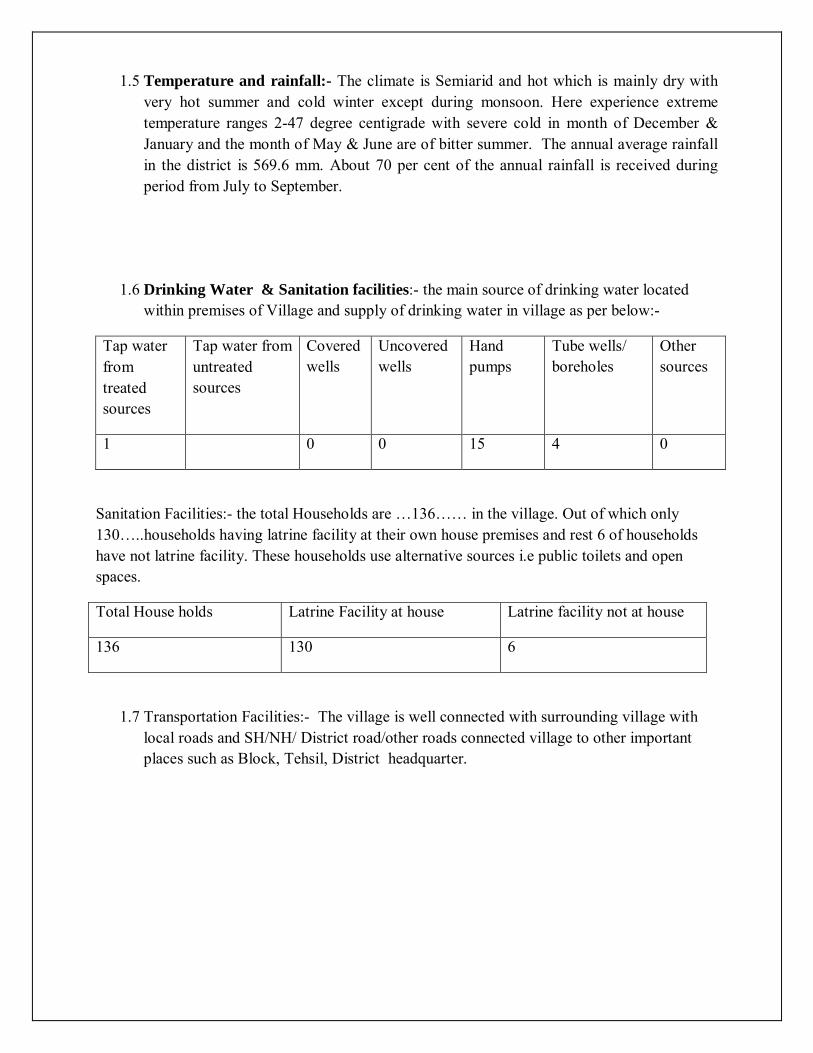
1.5 Temperature and rainfall:- The climate is Semiarid and hot which is mainly dry with very hot summer and cold winter except during monsoon. Here experience extreme temperature ranges 2-47 degree centigrade with severe cold in month of December & January and the month of May & June are of bitter summer. The annual average rainfall in the district is 569.6 mm. About 70 per cent of the annual rainfall is received during period from July to September.
1.6 Drinking Water & Sanitation facilities:- the main source of drinking water located within premises of Village and supply of drinking water in village as per below:-
Tap water from treated sources
Tap water from untreated sources
Covered wells
Uncovered wells
Hand pumps
Tube wells/ boreholes
Other sources
1 0 0 15 4 0
Sanitation Facilities:- the total Households are …136…… in the village. Out of which only 130…..households having latrine facility at their own house premises and rest 6 of households have not latrine facility. These households use alternative sources i.e public toilets and open spaces.
Total House holds Latrine Facility at house Latrine facility not at house
136 130 6
1.7 Transportation Facilities:- The village is well connected with surrounding village with local roads and SH/NH/ District road/other roads connected village to other important places such as Block, Tehsil, District headquarter.

Chapter-02
Hazard, Risk, vulnerability and Capacity Assessment
2.1 Hazard profile of Village:-
Hazards (in and around the village )
Hazard Probability (High / Med / Low)
Possible causes
Households vulnerable
Road Accidents Low Less number of vehicles
Flood High Drainage problem and mostly due to low lying area
136 households
Earthquake High Lies in Seismic zone IV
Landslide Low
Building collapse Low
Epidemic / Contagious disease
Med Large number of mosquitoes
Fire Low
Heat Wave Low
Cold Wave Low
Industrial / Chemical hazard
Low
Stampede Low
Animal Bite Low High number of street dogs
Snake Bite Low
Food Poisoning Med Open drains
Others (Electrocution) High Electric poles adjacent to houses

2.2 Vulnerability assessment:-
Details No. of HH
HH in low lying areas Nil
HH with poorly constructed houses Nil
Old aged population (above 65 age) 61
Children below (0-6 age) 36
Women headed households 20
BPL population 250
2.3 Capacity assessment:-
Name Location/ Address/ Landmark
Contact No Capacity/ Remark
Public Health facilities
Sub Centre Naggal 2 Km
Veterinary Centre Naggal 2 Km
Any other Pls Specify
Human Resource
Doctors 1
Specialist Doctors 1
Aurvedic Doctor Nil
Homeopathic Doctor 1
Veterinary Doctor 1
ANM 1
Paramedical staff (Other than ANM)
1
Trained Dai 0
Any other, Pls. Specify 0
Health [Private
Hospital Nil
Clinic Nil
Veterinary centre Nil
ANM Nil
Ambulance Nil
Medical Shops Nil
Pathological Lab Nil
Manpower [Private] Nos.
Doctos Nil
Specialist Doctor Nil
Paramedicals [Except ANMs]
Nil
Public
Police Station Naggal 2 Km
Fair Price Shop Ambala 12 Km
Petrol Pump Matheri Sekhan 6 Km
Kerosene Depot Segta
Gas Agency / Depot Naggal 2 Km
Other
Education
Infrastructure Nos. No. of Rooms
No. of Teachers No. of Students
Safe Shelters
(Yes / No)

Anganwadi centre 1 1 1 36
Primary school 1 3 1 14
Medium school
High school
Secondary school
Power & Communication
Electricity Yes / No Contact no Remarks
Electric Sub Station
Electricity Available in Village Yes
Street Light Facility Yes
Any Other No
Generator (Public) No
Generator (Private) Yes
Torches Yes
Communication (Public) Yes / No Contact no Remarks
Telephone Exchange No
Telephone Connection Yes
Mobile Phones Yes
Sirens No
Public Announcement System
Loud speakers Yes / No Contact no Remarks
Loud Speakers (Temple/ Masjid/ other religious institutions )
Temple 1
Gram Panchayats No
Sound Systems (Private) No
Tent house No
Other No

Market/ Shop
Grocery No
PDS No
Medicine No
Vegetables/ fruits market No
Internet Shop No
Major Bank Branches
Name of Banks No
ATM Machines No
Drinking Water Sources/ Water Supply
Water Supply (Public) Yes No If yes, numbers
Dam/ Check Dam No
Pond Yes 1
Well Yes 1
Tube well Yes 1
Hand pump Yes 15
Tap water Supply (at household) Yes 200
Community water post Yes 15
Water Tanker Supplier (GP owned) No
Water Tankers (Govt.) No
Other sources No
Water Supply (Private) Yes No If yes, numbers
Private Wells No
Private Tube Wells / Bore wells Yes 2
Private Hand Pumps No 2
Other

Sanitation
Facility Yes No Numbers, if yes
Public toilets No
Any open defecation site No
Open Defecation site No
Waste Disposal
Waste disposal area Pond
Dumpsters No
Burial Ground
Location of burial ground No
Location of animal carcass disposal area
No
Public Places of Recreation
Community hall No
Library No
Sports ground No
Parks No
Place of village meetings/ chaupal Yes 4
Place of Worship
Temple Yes 1
Mosque No
Church No
Gurudwara Yes 1
Monastery No
Others No

Connectivity
Infrastructure Type Yes No Condition
(Good, Bad, Normal)
Type of Road connectivity Yes Good
Pucca Road Yes Good
Kuchcha Road Yes Good
Any other, Specify
Bus Stand No
Whether Railway passes by? No
Railway Station No
Local auto/ taxi/ van stand
Transport (Public) Yes No Numbers, If yes
Bus
Mini Bus
Trucks
Jeep
Chhakda
Motor Bike/ Scooter Yes 50
Camel Cart/ Bullock Cart
Tractors Yes 35
Others [ ]
Safe Shelters During Disasters
School Building Yes 1
RCC Building (Individual houses) Yes 100
Others
Drivers Yes
Ex-Service Men Yes

Swimmer No
First Aid trainer No
Meson Yes 30
Carpenter Yes 4
2.4 Risk Analysis:-
Severity Hazard Elements at Risk
Vulnerable Areas
High Risk Hazards
Earthquake Human life, cattle life, public infrastructure, environment, etc.
Entire village falls in EQ Zone- IV i.e. high damage risk zone.
Chemical Accidents
Human Life, cattle life, Environment, etc.
.low no chemical factory in the village
Fires Human Loss, cattle life, agricultural produce, kutcha houses, industries, etc.
Households
Road Accidents
People travelling on roof/ inside buses. on national Highways, state Highways and other district. Cattle and other animals.
On ambala –hisar road
Medium Risk Hazards
Extreme Temperature
Human life, Cattle population, Crops, transportation activities.
Floods Human life,

cattle life, crop life, property and public infrastructure.
Epidemic Human Life, animal life
Low risk Hazards
Drought Human Life, crop life, Cattle life,
Entire district is prone to drought like condition. Ground water depletion is maximum as tube wells remain the alternate source of water.
Frost Thunder storm Hailstorm
Crop, cattle life Human life, crop , Cattle life, Public infrastructure
People with poor housing conditions in the village.
Terrorist Attack
Crowded places
Bus stops, Malls, Hospitals, Places of Worship, Melas etc in the district
Risk Analysis
Floods :
Floods due to faulty drainage system and due to low lying area and at time of monsoons the water gets accumulated at Ambala –Hisar road.
Fig : showing blocked drains in village segta Electrocution: Electrocution can take place as most of the electric wires are adjacent to households
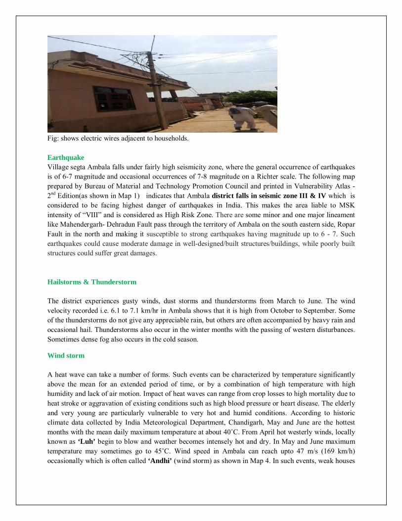
Fig: shows electric wires adjacent to households. Earthquake Village segta Ambala falls under fairly high seismicity zone, where the general occurrence of earthquakes is of 6-7 magnitude and occasional occurrences of 7-8 magnitude on a Richter scale. The following map prepared by Bureau of Material and Technology Promotion Council and printed in Vulnerability Atlas -2nd Edition(as shown in Map 1) indicates that Ambala district falls in seismic zone III & IV which is considered to be facing highest danger of earthquakes in India. This makes the area liable to MSK intensity of “VIII” and is considered as High Risk Zone. There are some minor and one major lineament like Mahendergarh- Dehradun Fault pass through the territory of Ambala on the south eastern side, Ropar Fault in the north and making it susceptible to strong earthquakes having magnitude up to 6 - 7. Such earthquakes could cause moderate damage in well-designed/built structures/buildings, while poorly built structures could suffer great damages. Hailstorms & Thunderstorm The district experiences gusty winds, dust storms and thunderstorms from March to June. The wind velocity recorded i.e. 6.1 to 7.1 km/hr in Ambala shows that it is high from October to September. Some of the thunderstorms do not give any appreciable rain, but others are often accompanied by heavy rain and occasional hail. Thunderstorms also occur in the winter months with the passing of western disturbances. Sometimes dense fog also occurs in the cold season.
Wind storm A heat wave can take a number of forms. Such events can be characterized by temperature significantly above the mean for an extended period of time, or by a combination of high temperature with high humidity and lack of air motion. Impact of heat waves can range from crop losses to high mortality due to heat stroke or aggravation of existing conditions such as high blood pressure or heart disease. The elderly and very young are particularly vulnerable to very hot and humid conditions. According to historic climate data collected by India Meteorological Department, Chandigarh, May and June are the hottest months with the mean daily maximum temperature at about 40˚C. From April hot westerly winds, locally known as ‘Luh’ begin to blow and weather becomes intensely hot and dry. In May and June maximum temperature may sometimes go to 45˚С. Wind speed in Ambala can reach upto 47 m/s (169 km/h) occasionally which is often called ‘Andhi’ (wind storm) as shown in Map 4. In such events, weak houses

of thatch, sheets etc. will suffer damage. However, the damage occurring from 'Andhis' is again of localized nature and does not result in ‘disaster’ in the region.
Fire Fire is a major disaster in rural areas in district Ambala generating risk to residential, commercial, educational, institutional . Most of the accident reported in the villag is due to inadequate safety measures in the electrical installation, chemical and LPG blasts, as well as careless practices while handling and storage of inflammable materials. Epidemics Risk of communicable diseases is high in village segta due to uncleaened blocked drains which give birth to various diseases . The main epidemics can be in the form of cerebral malaria, dengue fever, cholera and other water borne deceases, new situations like plague, AIDS etc cannot be ruled out. Animal bite The ratio of street dogs is high which increases the risk of dog bite incidents .

Chapter-03
Response Plan
3.1 Village Disaster Management Committee :- to carry out disaster management activities
i.e. village disaster management plan, training and awareness activities, identification of
resources and search & rescue activity at village level conducted by Village Disaster
Management Committee. The following is the suggestive list of committee members:-
Sr.No. Name Designation Contact number
1. Sarpanch Baljinder Singh Chairman 9466223817
2. Panchayat secy Nodal Officer 9466070376
3. Patwari- Ran Singh Member 9416448849
4. Numbardar Prem Singh Member
5. SC panch –Rajbir Singh Member
6. BC panch- Sukhdev SIngh Member
7. Anganwari worker- Anita Member 09416313181
8. SHG heads Member
9. School representative Member
10. Sub-Centre representative Member
11. Woman Panch Member
12. Ex-servicemen Member
13. Agriculture Development Officer Member
14. Animal Husbandry representative Member
15. (Any other representative that can be resourceful as per the village)
Member

3.2 Village Disaster Management teams :-
S. No. Name Designation Contact Number Contact Address
Early Warning and Information Dissemination Team
1. Harbans Singh 9466412266
2. Jagtar 9416295607
3. Rajbir Singh 9416553582
4. Pritam Singh 8607484494
Evacuation Team
1. Baljinder Singh 9466223817
2. Rajbir Singh 9466026924
Search and Rescue Team
1. Vikas 9416295607
2. Pritam Singh 8605484494
First Aid Team
. Jagtar Singh 9416295607
2. Rajbir Singh 9416553582
Relief Management Team
1. Om Parkash 981332686
Sanitation Team
1. Sukhdev Singh 9466328126
Shelter Management Team
1. Pritam Singh 8607484944

Carcass Disposal Team
1. Rajbir Singh 9466553582
Damage & Need Assessment Team
1. Jagtar Singh 9416295607
Rehabilitation & Reconstruction Team
1. Kulwant Singh 9416135022
3.3 Working NGOs and Self Help Groups in Village:-
Sr.No Name of organisation Sector Contact number
1. Ram Kumar 9467801762
2.
3.

Chapter-04
Mitigation and Preparedness plan
4.1. Standard Operating Procedures
The teams formed in the previous chapter, their SOPs shall be listed down here. For eg:
4.1.1. Early Warning & Information Dissemination Team Communicate the information with other teams. Update contact details of local resources/ offices, etc...
4.1.2. Evacuation Team Keeping evacuation map of the village with them. Knowing the way of evacuation from the village. Identifying safe evacuation routes, places, assembly points in and around the
village. 4.1.3. Search & rescue team
Search people who trapped in buildings and rescue them. Transport victims to safe location.
4.1.4. First Aid Team Maintain list of pregnant women, infants, people with special medical needs,
etc. Keeping First-Aid box with disinfectants, antiseptics, ORS, etc. Updated contact number of emergency services i.e. Ambulance, near hospital
public & private. 4.1.5. Relief Management team
To provide relief materials i.e. food, water, cloths, utensils and other essential material for who evacuated and rescued from village.
4.1.6. Shelter Management team Identify safe shelter in village, open spaces for tents installation and nearby
areas in case of evacuate the people from village. 4.1.7. Carcass Disposal Team Identification of space for carcass disposal. Stocking kerosene and fuel for disposal of carcass. Maintaining storage of sackcloth to cover dead bodies of animals. Proper spray of disinfectants (eg: DDT) to keep the air clean
4.1.8. Damage & Need Assessment Team Help in forecasting damages including lives lost and losses to property and
assets such as houses, livestock, agriculture, plantation, etc. Sensitizing families of village to keep their important documents safe, and in
emergency kit. 4.1.9. Reconstruction & Rehabilitation Team Get purified water sources in village.
Prepare reconstruction and rehabilitation plan for vulnerable groups/areas in the village.
4.2. Identify Safe Evacuation Routes
Selection of evacuation route that minimize the exposure to the hazard and other obstacles
Evacuation route to be easily accessible even for vulnerable groups such as, women, children, and elderly. Evacuation Map of the village
4.3. Community level Mitigation Programme Include hazard specific mitigation measures and schemes running in the village
4.3.1. Flood Mitigation Construction of bundhs around settlement. Construction of flood shelter Drainage channels to be cleared Construction of raised platforms near important/ vulnerable areas, such as
school, shelter of animals, gaushalas, etc. 4.3.2. Earthquake Mitigation Detailed survey of buildings for assessment of damage and repair/
reconstruction and seismic strengthening or demolition Training the local masons for constructing earthquake resistant structures Conducting mock drills in villages for evacuation during an earthquake Fix all objects in houses that can fall and cause injury (non structural
mitigation) 4.3.3. Drought Mitigation Continuous drought monitoring through rainfall situation, water availability in
reservoirs, rivers, canals, etc. and comparing with existing water needs of society.
Water conservation through rainwater harvesting in houses and farmers’ fields.
Allowing runoff water from all fields to a common point (eg: pond) or allowing it to infiltrate in the soil where it has fallen.
Generating awareness among the village people on implementing water conservation and agriculture awareness programs through television, pamphlets, nukkad natak, etc.
Chapter-05
1. Gram Panchayat contacts:-
Sr.No Elected person Name Contact
1. Sarpanch Baljinder Singh 9466223817
2. Ward No.1 Panch Rajbir Singh 9466026924
3. Ward No.2 Panch Joginder Singh 9416295607
4. Ward No.3 Panch Om Parkash 9813322686
5. Ward No.4 Panch Saroj Bala 9416181266
6. Ward No.5 Panch Sukhdev singh 9466328126
5.4 Other Important contact numbers:-
Sr.No. Name Contact No.
1. Namardar Kulwant singh 9416135022
2. Chokidar Ram Kumar 9467807162
3. ANM Krishna
4. ASHA Naresh kaur
5. Aganwari Anita 9416313181
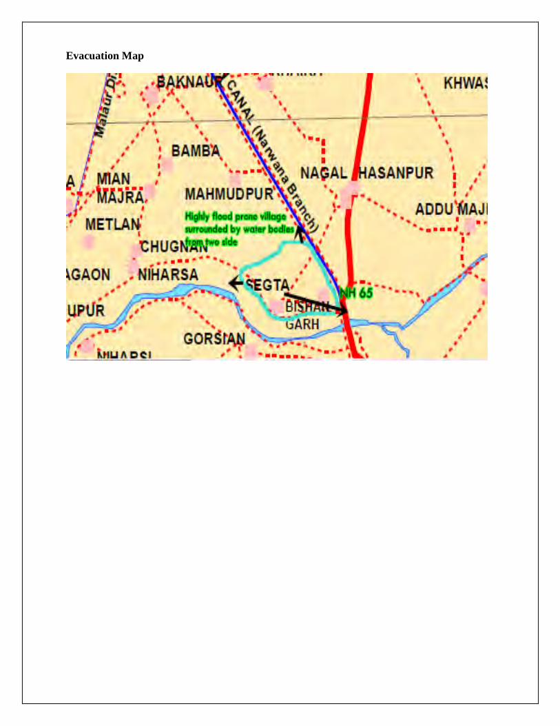
Evacuation Map