Village Assessment Survey COUNTY ATLAS -...
30
Village Assessment Survey COUNTY ATLAS 2013 Unity State Mayendit County
Transcript of Village Assessment Survey COUNTY ATLAS -...

Village Assessment Survey
COUNTY ATLAS
2013
Unity State
Mayendit County

Six (6) Counties Assessed
Map
In
dex
Village Assessment Survey
Planning Map and Dashboard..…………Page 1
General Section…………...……...Page 2 - 5
Main Ethnicities and Languages.………...Page 2
Infrastructure and Services……...............Page 3
Land Ownership and Settlement Type ….Page 4
Returnee Land Allocation Status..……...Page 5
Livelihood Section…………..…...Page 6 - 9
Major Livelihood Practices..…………...Page 6
Major Food Crops Grown...…………..Page 7
Major Problem Affecting Farming……..Page 8
Major Livelihood Shocks……….............Page 9
Health Section………..………..Page 10 - 13
Access to Health Facilities……………Page 10
Health Facility & Services Offered...Page 11& 12
Health Awareness Programmes………Page 13
WASH Section…………..………...Page 14 - 20
Natural Source of Water……...……….…..Page 14
Water Point and Physical Accessibility….…Page 15
Water Management & Conflict....….………Page 16
WASH Education...….……………….…….Page 17
Latrine Type and Use...………....………….Page 18
Education Section………….……...Page 19 - 22
Access to Education Facilities...……………Page 19
Level of Edu. & Medium of Instruction...…..Page 20
Teacher to Student Ratio...……………….Page 21
Primary School Facilities...…………………Page 22
Protection Section…………..…….Page 23 - 25
Presence of Rule of Law Institutions...…….Page 23
External Threats, Violations & Risks...……..Page 24
Internal Threats, Violations & Risks...……...Page 25
The Village Assessment Survey (VAS) has been used by IOM since 2007 and is a comprehensive
data source for South Sudan that provides detailed information on access to basic services, infra-
structure and other key indicators essential to informing the development of efficient reintegra-
tion programmes. The most recent VAS represents IOM’s largest effort to date encompassing 30
priority counties comprising of 871 bomas, 197 payams, 468 health facilities, and 1,277 primary
schools. There was a particular emphasis on assessing payams outside state capitals, where com-
paratively fewer comprehensive assessments have been carried out. IOM conducted the assess-
ment in priority counties where an estimated 72% of the returnee population (based on esti-
mates as of 2012) has resettled.
The county atlas provides spatial data at the boma level and should be used in conjunction with
the VAS county profile.
INTERNATIONAL ORGANIZATION FOR MIGRATION
New Industrial Area ● Northern Bari ● Juba ● South Sudan
Email: [email protected] | Web: http://southsudan.iom.int
Established in 1951, IOM is the principal inter governmental organization in the field of migration and works closely with governmental, intergovernmental and non-governmental partners. With 149 member states, a further 12 states holding observer status and offices in over 100 countries,
IOM works to help ensure the orderly and humane management of migration, to promote international cooperation on migration issues, to assist in the search for practical solutions to migration problems and to provide humanitarian assistance to migrants in need, including refugees and inter-
nally displaced people
This map product is for planning purposes only. The names and boundaries on this
map product/atlas do not imply official endorsement or acceptance by the Govern-
ment of Republic of South Sudan or IOM. IOM cannot guarantee that this map is
error free and therefore will not accept liability for consequential and indirect dam-
ages arising from the use of this map product. DIS
CLA
IMER
O
VERV
IEW
MA
P
Page Numbers preceded by reflect data sourced from the Boma Questionnaire, while page numbers preceded by present information sourced
from the respective Technical Questionnaire.
Please refer to the accompanying digital atlas for more detailed information of the map
product. Maps are also available at http://southsudan.iom.int/reports/VAS or scan the QR
code below to go directly to the web page.

9
9
9
999
9
9
99
9
999
9
9
99
9
9
9
99
9
9
99
9
RumbekNorth
( Lakes )
Panyijar( Unity )
Leer( Unity )
Koch( Unity )
Tonj East( Warrap )
Tonj North( Warrap )
Duk( Jonglei )
Ayod( Jonglei )
Fangak( Jonglei )
Luongyier TwoKapiny
BengDhorpouk Toch
WangkanKuol
TharnorMayiadit
Gak
BanejiekKerthiang
Kotway
Letwich One
KaiNyien
Borrar LiethGuolmut
KotnyakNyamounGoklum
BiluanyDhorLoay
Key
Nyakoy
WangKueth
KekDabek
Kuloy
Tuh
Dhor Deng
Taryaang
Boaw
DhornyagaiTheng
ThaliayKuer Mutdeng
Nyanyaguar
Katuok
KotraarKhatTwoKuer Dut
Pourkuow
Kotrar
Tatkath
Wang Belah
DhortilKoat Two
WanleekLathtang
LuonyierChotChar
DianywalOne
ThuokyierYak
KechBiet
DianywalTwo
RitgokMajak
Kok
Nyabhar
DhokDok Two
Tharbuowa
Mou
Kuerlel
Kuerlam
Paguol
Goany MajokJill
DokDhorriekJut
MankienBhargok
Korow Ber
Jieydit
DhiachDhornori
Dhornyamai Tangkuer
PanyangOne
PanchueyKuorwayTharway
PantotPangatluokmaborDhorlyanyaha
DhornyanhialdolKuankuetGapriak Two
Gapriak One
Pankuony
Maper CentreGanangchielam
Chotjiok
Maperchiebany
Nyarup
LokwurLoang
Dhorparjoak TharjiathborDhomkow
BathlarDhorkeym Bouth
MabelMakuacBot
Thepkot
Manyal
MalbekBuony
Lian
WangkongMayen
DhorthierBathjiop
Kuol
Padeah
Bang DholThow Kuok
Puol Lual
Dhorgapni
RieriBiemthuok
Dhorlek
Kah
Tharthep
Nhiar Nhiar
Luom
Thoryiel
KechDhorthier
Chot Lual
Kangkoi
Rubnor
JaguarGapriak
Maper
Kuok
LianThor
Malbek
Planning Map & Dashboard
Panyijar
Mayendit Leer
Koch
Mayom GuitRubkona
Abiemnhom
Pariang
Lakes
UpperNile
WesternBahr elGhazal
UnityNorthernBahr elGhazal
JongleiWarrap
Area Payams Bomas
Villages HealthFacilities
EducationFacilities
Data Source:Year:Projection:Spheroid:Comments & Feedback:Map Index:
NBS, OCHA, IOM, ESRI2013
GeographicWGS84
[email protected]/SS/VAS/S19C008/PLN
km2 8 28330 11 16
3,067
Returnees to the County Compared with State Total
59,672ESTIMATED HOST POPULATION:
RETURNEE POPULATION: 16,426
Percentage of Returnees to the Host Population0% 100%
Legend
9 Boma Survey PointsVillages
&( State CapitalRiverLakes
RoadsLocal/UrbanPrimarySecondaryTertiaryCounty BoundaryState Boundary
Mayendit County Page 1
28%
* Final Boundary between the Republic of South Sudan and the Republic of Sudan has not yet been determined.** Final status of the Abyei area is not yet determined
AbyeiAdmin.Area**
SUDAN
0 10 20 305Kilometers
:
9,047
34,386
55,944
98,637
79,842
12,122478 3,006 1,637
7,716 3,589 850
20,000
40,000
60,000
80,000
100,000
120,000
2007 2008 2009 2010 2011 2012
Retur
nees
Year of Return
Unity Mayendit
Payam Boma Number of Villages
Kuol 5Dhorthier 6Bathjiop 5Thow Kuok 7Padeah 5Bang Dhol 7Puol Lual 6Dhorgapni 5Rieri 17Biemthuok 18Dhorlek 15Kah 17Tharthep 20Nhiar Nhiar 10Thoryiel 20Luom 10Kech 5Chot Lual 5Dhorthier 5Kangkoi 15Rubnor 39Jaguar 11Kuok 17Maper 10Gapriak 6Lian 16Thor 11Malbek 17
Rubkuay
Thaker
Tharjiath Bor
VILLAGE INFORMATION
Babuong
Bor
Dablual
Luom
Mal

RumbekNorth
( Lakes )
Panyijar( Unity )
Leer( Unity )
Koch( Unity )
Tonj East( Warrap )
Tonj North( Warrap )
Duk( Jonglei )
Ayod( Jonglei )
Fangak( Jonglei )
DhorthierBathjiopKuol
PadeahThow Kuok
Puol Lual
Dhorgapni
RieriDhorlek
Tharthep
Luom
Thoryiel
KechDhorthier
Chot Lual
Kangkoi
Rubnor
JaguarGapriak
Maper
Kuok
Lian
Thor
Malbek
..
.
.
.
.
.
.
.
.
.
..
.
.
.
..
.
.
.
..
.
.
..
.
VillagesRiver/StreamLake/Marsh
Main TribesNuer
RoadsLocal/UrbanPrimarySecondaryTertiaryCounty BoundaryState Boundary
Main Ethnicities and Languages Spoken
Mayendit County
Main Languages
Legend
Page 2
Data Source:Year:Projection:Spheroid:Comments & Feedback:Map Index:
NBS, OCHA, IOM, ESRI2013
GeographicWGS84
[email protected]/SS/VAS/S19C008/THM010 10 20 305
Kilometers
. Nuer
. English
. Nuer (Thoknaath)
Nuer Nuer (Thoknaath) English Total BomasNuer 27 0 1 28Total Bomas 27 0 1 28
MAIN LANGUAGE SPOKENMayendit
MAIN TRIBE
COUNTY

9
9
9
9
99
9
9
99
9
9
9
9
9
9
9
9
9
9
9
99
9
9
9
9
9
9
9
9
9
99
9
9
99
9
9
9
9
9
9
9
9
9
9
9
99
9
9
9
9
9
Panyijar( Unity )
Leer( Unity )
Koch( Unity )
Tonj East( Warrap )
Tonj North( Warrap )
Ayod( Jonglei )
Dhorthier
Bathjiop
Kuol
Padeah
Bang Dhol
Thow Kuok
Puol Lual
Dhorgapni
Rieri
Biemthuok
Dhorlek
Kah
Tharthep
Nhiar Nhiar
Luom
Thoryiel
Kech
Dhorthier
Chot Lual
Kangkoi
Rubnor
JaguarGapriak
Maper
Kuok
Lian
Thor
Malbek
r E W N N
r E W
r E W
E B W
E B W
E
B
r E B
B
O W
r E O W
r E B
r O B W
r W
Boma Survey Points9 Bomas with Infrastructure
9 Bomas without InfrastructureVillages
RoadsLocal/UrbanPrimarySecondaryTertiary
River/StreamLake/MarshCounty BoundaryState Boundary
Mayendit County
Legend
Infrastructure Police Station Orphanage Boma
MarketPublic
TransportMobile
CoverageReligious
Est. Roads Bridges
Number of Bomas 8 0 9 3 0 7 9 2
Satisfaction Level 0% 0% 0% 0% 0% 14% 0% 0%
B W NMayendit r @ E O 4
Infrastructure and Services
Page 3
Data Source:Year:Projection:Spheroid:Comments & Feedback:Map Index:
NBS, OCHA, IOM, ESRI2013
GeographicWGS84
[email protected]/SS/VAS/S19C008/THM02
999
9999
9
999999
9
9
99
9
9
9
99
99
99
9
Lakes
Jonglei
Warrap
0 8 16 244Kilometers

9
9
9
9
99
9
9
9
9
9
9
9
9
9
9
9
9
9
9
9
9
9
9
9
9
9
9
Leer( Unity )
Koch( Unity )
Tonj East( Warrap )
Tonj North( Warrap )
Dhorthier
Bathjiop
Kuol
Padeah
Bang DholThow Kuok
Puol Lual
Dhorgapni
Rieri
Biemthuok
Dhorlek
Kah
Tharthep
Nhiar Nhiar
Luom
Thoryiel
Kech
Dhorthier
Chot Lual
Kangkoi
Rubnor
Jaguar
Gapriak
Maper
Kuok
Lian
Thor
Malbek
d
d
d
>d
d
d
d
d
$ > d
$ > d /
$ d
$ d /
$ > d /
$ d
$ d
>d
d
d
d
$ d
$ d
$ d$
$$
$>
>d
$>
Legend9 Boma Survey Points
Villages
RoadsLocal/UrbanPrimarySecondaryTertiaryRiver/StreamLake/MarshCounty BoundaryState Boundary
Land Ownership & Settlement Types
Mayendit County
$>d\
Individual
Free Communal
Ancestral
Leased Land
Land Ownership Type
/ Informal Land Tenure
Page 4
Data Source:Year:Projection:Spheroid:Comments & Feedback:Map Index:
NBS, OCHA, IOM, ESRI2013
GeographicWGS84
[email protected]/SS/VAS/S19C008/THM03
999
9999
9
999999
99
99
9
99
9999
99
9
Lakes
Jonglei
Warrap
0 6 12 183Kilometers
P erma-nent
Seaso -nal
T emp-o rary
N o ma-dic
RubnorJaguarKangkoiRieriDhorlekBiemthuokKahTharthepNhiar NhiarThorLian
Malbek
ThoryielLuomKuokMaperGapriakDhorthierChot LualKechThow KuokBang DholPuol LualDhorgapniPadeahBathjiopKuolDhorthierTotal 28 10 6 6
Bor
Babu
ong
Payam Boma TYPE OF SETTLEMENT
Rubk
uay
Dablu
alTh
arjiat
h Bor
Luom
Thake
rMa
l

RumbekNorth
( Lakes )
Panyijar( Unity )
Leer( Unity )
Koch( Unity )
Tonj East( Warrap )
Tonj North( Warrap )
Duk( Jonglei )
Ayod( Jonglei )
Fangak( Jonglei )
DhorthierBathjiop
Kuol
Padeah
Bang DholThow Kuok
Puol Lual
Dhorgapni
RieriBiemthuok
Dhorlek
KahTharthep
Nhiar Nhiar
Luom
Thoryiel
KechDhorthier
Chot Lual
Kangkoi
Rubnor
JaguarGapriak
Maper
Kuok
LianThor
Malbek
LegendLand Allocation Status by Boma
YesNot specifiedNoVillagesRiver/StreamLake/Marsh
RoadsLocal/UrbanPrimarySecondaryTertiaryCounty BoundaryState Boundary
Returnee Land Allocation Status
Mayendit County Page 5
Data Source:Year:Projection:Spheroid:Comments & Feedback:Map Index:
NBS, OCHA, IOM, ESRI2013
GeographicWGS84
[email protected]/SS/VAS/S19C008/THM040 10 20 305
Kilometers

9
9
9
9
99
9
9
99
9
9
9
9
9
9
9
9
9
9
9
9
9
9
9
9
9
9
9
9
9
9
99
9
9
99
9
9
9
9
9
9
9
9
9
9
9
9
9
9
9
9
9
9
Panyijar( Unity )
Leer( Unity )
Koch( Unity )
Tonj East( Warrap )
Tonj North( Warrap )
Dhorthier
Bathjiop
Kuol
Padeah
Bang Dhol
Thow Kuok
Puol Lual
Dhorgapni
Rieri
Biemthuok
Dhorlek
Kah
Tharthep
Nhiar Nhiar
Luom
Thoryiel
Kech
Dhorthier
Chot Lual
Kangkoi
Rubnor
JaguarGapriak
Maper
Kuok
Lian
Thor
Malbek
l U o F
l U o F
l U o F
l U o F
l U o F
l U o F
l U o F
l U o F
l U o F
l U F
l U F
l U F
l U F
l U F
l U o
l U F
l U o F
l U o F
l U o F
l U o
l U o
l U ol U o
l U o F
l U o
l U F
l U o F
l U o F
LegendBoma Survey Points9 Reported
9 Not Reported Villages
River/StreamLake/Marsh
RoadsLocal/UrbanPrimarySecondaryTertiaryCounty BoundaryState Boundary
Mayendit County
lUo
FarmingLivestock
Fishing
Major Livelihood Practices and Seasonal Migration
F Migration
Page 6
Data Source:Year:Projection:Spheroid:Comments & Feedback:Map Index:
NBS, OCHA, IOM, ESRI2013
GeographicWGS84
[email protected]/SS/VAS/S19C008/THM05
Major Livelihood Practices
999
9999
9
999999
9
9
99
9
99
9999
99
9
Lakes
Jonglei
Warrap
0 7 14 213.5Kilometers
Farming, 36% Livestock, 36%
Fishing, 27%
Other, 1%
0% 20% 40% 60% 80% 100%
Liveli
hood
Acti
vities

9
9
9
9
99
9
9
99
9
9
9
9
9
9
9
9
9
9
9
9
9
9
9
9
9
9
9
9
9
9
99
9
9
99
9
9
9
9
9
9
9
9
9
9
9
9
9
9
9
9
9
9
Leer( Unity )
Koch( Unity )
Tonj East( Warrap )
Tonj North( Warrap )
Dhorthier
Bathjiop
Kuol
Padeah
Bang Dhol
Thow Kuok
Puol Lual
Dhorgapni
RieriBiemthuok
Dhorlek
Kah
Tharthep
Nhiar Nhiar
Luom
Thoryiel
Kech
Dhorthier
Chot Lual
Kangkoi
Rubnor
Jaguar
Gapriak
Maper
Kuok
Lian
Thor
Malbek
l s
l s
l s
l s t n n
l s n n
l s n
l s
l s l
l s n l
l s n l
l s l
l s
l s
l s
l s
l s
l s
l s n
l sl s
l s
l s n n
l s n
l s
l s n
LegendBoma Survey Points9 Food Crops Reported
9 No Food Crops ReportedVillagesRiver/StreamLake/Marsh
RoadsLocal/UrbanPrimarySecondaryTertiaryCounty BoundaryState Boundary
Mayendit County
lstnnlsE
MaizeSorghum
SesameGroundnuts
Vegetables
Millet
CassavaRice
Major Food Crops Grown
Page 7
Data Source:Year:Projection:Spheroid:Comments & Feedback:Map Index:
NBS, OCHA, IOM, ESRI2013
GeographicWGS84
[email protected]/SS/VAS/S19C008/THM06
Major Food Crops
999
9999
9
999999
9
9
99
9
9
9
99
99
99
9
Lakes
Jonglei
Warrap
0 6 12 183Kilometers
Maize, 28
Sorghum, 28
Sesame, 3
Groundnut, 8
Vegetable, 10
Millet, 6
Cassava, 1
0 5 10 15 20 25 30Maize
Sorghum
Sesame
Groundnut
Vegetable
Millet
Cassava
Rice
Number of Bomas
Major Food Crops Grown in the County

9
9
9
9
99
9
9
99
9
9
9
9
9
9
9
9
9
9
9
9
9
9
9
9
9
9
Leer( Unity )
Koch( Unity )
Tonj East( Warrap )
Tonj North( Warrap )
Dhorthier
Bathjiop
Kuol
Padeah
Bang Dhol
Thow Kuok
Puol Lual
Dhorgapni
Rieri
Biemthuok
Dhorlek
Kah
Tharthep
Nhiar Nhiar
Luom
Thoryiel
Kech
Dhorthier
Chot Lual
Kangkoi
Rubnor
Jaguar
Gapriak
Maper
Kuok
Lian
Thor
Malbek
n C D u
n C D u
n C D
n C + D
n C D u
n C + D u
n C + D u
n C D u
n C + D u
n C + D u
n C + u
n C D u
C + D u
n C + D u
n C + u
n C u
n D u
D u
D u
C D u
n C D u
n C D u
n C
n C u
n C u
n C + D
n C
n C D
Legend9 Boma Survey Points
VillagesRiver/StreamLake/Marsh
RoadsLocal/UrbanPrimarySecondaryTertiaryCounty BoundaryState Boundary
Major Problems Affecting Farming
Mayendit County
nC+Du
Crop DiseaseOther Crop Damage*
Market Accessibility
ConflictNatural Disaster
Page 8
Data Source:Year:Projection:Spheroid:Comments & Feedback:Map Index:
NBS, OCHA, IOM, ESRI2013
GeographicWGS84
[email protected]/SS/VAS/S19C008/THM07
Major Problems (Farming)
*Other Crop Damage includes damage caused by: Livestock, Wildlife, Birds & Insects/Pest
999
999
9
9
999999
9
9
99
9
9
9
99
9
9
99
9
Lakes
Jonglei
Warrap
0 6 12 183Kilometers
Lack of Input27%
Drought20%Storage
Facility15%
Market Facility22%
Conflict16%
Major Problem Affecting Fishermen
Grazing Land19%
Drought15%
Water20%
Market Fac.12%
Conflict14%
Diseases20%
Major Problem Affecting Livestock Herders

Leer( Unity )
Koch( Unity )
Tonj East( Warrap )
Tonj North( Warrap )
Dhorthier
Bathjiop
Kuol
Padeah
Bang DholThow Kuok
Puol Lual
Dhorgapni
RieriBiemthuok
Dhorlek
Kah
Tharthep
Nhiar Nhiar
Luom
Thoryiel
Kech
Dhorthier
Chot Lual
Kangkoi
Rubnor
JaguarGapriak
Maper
Kuok
Lian
Thor
Malbek
z
u U
u U D
u U w n D
u z U w D
u U w n D
U w D
u z U
u U w n D
u z U w n I D
u z U w n I D
u z U w n I D
u z U w n I D
u z U w n I D
w
z w n
z U
D
z
w D
z UD
U w n
U w
U w
U Dn I D
U n
LegendLivelihood Shock Experienced
YesNot specifiedNoVillagesRiver/StreamLake/Marsh
RoadsLocal/UrbanPrimarySecondaryTertiaryCounty BoundaryState Boundary
Major Livelihood Shocks (Last Two Years)
Mayendit County
uzUwnID
DroughtFloodLivestock diseaseHuman EpidemicCrop DiseasePestConflict
Page 9
Data Source:Year:Projection:Spheroid:Comments & Feedback:Map Index:
NBS, OCHA, IOM, ESRI2013
GeographicWGS84
[email protected]/SS/VAS/S19C008/THM08
Livelihood Shocks
999
999
9
9
999999
9
9
99
9
9
9
99
9
9
99
9
Lakes
Unity
Jonglei
Warrap
0 6 12 183Kilometers

RumbekNorth
( Lakes )
Panyijar( Unity )
Leer( Unity )
Koch( Unity )
Tonj East( Warrap )
Tonj North( Warrap )
Duk( Jonglei )
Ayod( Jonglei )
Fangak( Jonglei )
DhorthierBathjiop
Kuol
Padeah
Bang DholThow Kuok
Puol Lual
Dhorgapni
Rieri
Biemthuok
Dhorlek
Kah
Tharthep
Nhiar Nhiar
Luom
Thoryiel
KechDhorthier
Chot Lual
Kangkoi
Rubnor
JaguarGapriak
MaperKuok
LianThor
Malbek
wff
x
xx
x
x
x
xw
Legend9 Boma Survey Points
VillagesAccess to Health Facility
Easy
Medium
Difficult
River/StreamLake/Marsh
RoadsLocal/UrbanPrimarySecondaryTertiaryCounty BoundaryState Boundary
Access to Health Facilities
Mayendit County
zwx
HospitalPHCCPHCU
Page 10
Data Source:Year:Projection:Spheroid:Comments & Feedback:Map Index:
NBS, OCHA, IOM, ESRI2013
GeographicWGS84
[email protected]/SS/VAS/S19C008/THM09
PHCC: Primary Health Care CentrePHCU: Primary Health Care Unit
Type of Health Facility
f Others
0 10 20 305Kilometers
Payam Bomas Bomas with Health Facility Hospitals PHCC PHCU Others
Rubkuay 3 1 0 1 0 2Dablual 6 1 0 0 0 0Tharjiath Bor 3 2 0 0 2 0Luom 2 2 0 0 2 0Thaker 3 1 0 0 1 0Mal 3 1 0 0 1 0Bor 5 1 0 1 0 0Babuong 3 0 0 0 0 0
HEALTH FACILITY INFORMATION

9
9
9
9
99
9
9
99
9
9
9
9
9
9
9
9
9
9
9
9
9
9
9
9
9
9
Leer( Unity )
Koch( Unity )
Tonj East( Warrap )
Tonj North( Warrap )
Dhorthier
Bathjiop
Kuol
Padeah
Bang DholThow Kuok
Puol Lual
Dhorgapni
RieriBiemthuok
Dhorlek
Kah
Tharthep
Nhiar Nhiar
Luom
Thoryiel
Kech
Dhorthier
Chot Lual
Kangkoi
Rubnor
Jaguar
Gapriak
Maper
Kuok
Lian
Thor
Malbek
>>
>
>&
>
>&
>h
&
>
>&
>
Legend9 Boma Survey Points
VillagesHealth Facilities
Services ReportedNo Services Reported
River/StreamLake/Marsh
RoadsLocal/UrbanPrimarySecondaryTertiaryCounty BoundaryState Boundary
Mayendit County
Health Facilities and Services Offered
Page 11
Data Source:Year:Projection:Spheroid:Comments & Feedback:Map Index:
NBS, OCHA, IOM, ESRI2013
GeographicWGS84
[email protected]/SS/VAS/S19C008/THM10
Lakes
Jonglei
Warrap
0 6 12 183Kilometers
>A&Lh/
Out Patient
In PatientMaternity Ward
Laboratory
Feeding CentrePsycho-Social Support
Services Offered
Please refer to the next map for more services

9
9
9
9
99
9
9
9
9
9
9
9
9
9
9
9
9
9
9
9
9
9
9
9
9
9
9
Leer( Unity )
Koch( Unity )
Tonj East( Warrap )
Tonj North( Warrap )
Dhorthier
Bathjiop
Kuol
Padeah
Bang DholThow Kuok
Puol Lual
Dhorgapni
RieriBiemthuok
Dhorlek
Kah
Tharthep
Nhiar Nhiar
Luom
Thoryiel
Kech
Dhorthier
Chot Lual
Kangkoi
Rubnor
Jaguar
Gapriak
Maper
Kuok
Lian
Thor
Malbek
x L
x [
x [
x h ex h L D e
x L ex h L
x
h L
x
x h L e
Legend9 Boma Survey Points
VillagesHealth Facilities
Services ReportedNo Services Reported
River/StreamLake/Marsh
RoadsLocal/UrbanPrimarySecondaryTertiaryCounty BoundaryState Boundary
Mayendit County
Health Facilities and Services Offered (Continued)
Page 12
Data Source:Year:Projection:Spheroid:Comments & Feedback:Map Index:
NBS, OCHA, IOM, ESRI2013
GeographicWGS84
[email protected]/SS/VAS/S19C008/THM10
Lakes
Jonglei
Warrap
0 6 12 183Kilometers
xhLD[e
Drug Dispensary
Epidemiological Data
ImmunizationVehicles for Referral
Paid ServiceHealth Education
Services Offered

9
9
9
9
99
9
9
99
9
9
9
9
9
9
9
9
9
9
9
9
9
9
9
9
9
9
Panyijar( Unity )
Leer( Unity )
Koch( Unity )
Tonj East( Warrap )
Tonj North( Warrap )
Ayod( Jonglei )
Dhorthier
Bathjiop
Kuol
Padeah
Bang Dhol
Thow Kuok
Puol Lual
Dhorgapni
RieriBiemthuok
Dhorlek
Kah
Tharthep
Nhiar Nhiar
Luom
Thoryiel
Kech
Dhorthier
Chot Lual
Kangkoi
Rubnor
Jaguar
Gapriak
Maper
Kuok
Lian
Thor
Malbek
LL e
L e
L e
L e
L e
L e
L e
L eL
L
L
L
L
L
L
L e
L
L
L
L eL
L
L
L
L
L
Legend9 Boma Survey Points
VillagesRiver/StreamLake/Marsh
RoadsLocal/UrbanPrimarySecondaryTertiaryCounty BoundaryState Boundary
Health Awareness Programmes (Boma Perspective)
Mayendit County Page 13
Data Source:Year:Projection:Spheroid:Comments & Feedback:Map Index:
NBS, OCHA, IOM, ESRI2013
GeographicWGS84
[email protected]/SS/VAS/S19C008/THM11
Le
Health Awareness Prog.ImmunizationHIV/AIDS EducationHealth Education
STID: Sexually Transmitted Infectious DiseasesOTD: Other Transmitted Diseases
999
9999
9
999999
9
9
99
9
99
9999
99
9
Lakes
Jonglei
Warrap
0 7 14 213.5Kilometers
Payam Boma
Hygie
neCh
ild
Nutri
tion
Fam
ily
Plann
ingRe
prod
uctiv
e He
alth
STID
OTD
RubnorJaguarKangkoiRieriDhorlekBiemthuokKahTharthepNhiar NhiarThorLianMalbekThoryielLuomKuokMaperGapriakDhorthierChot LualKechThow KuokBang DholPuol LualDhorgapniPadeahBathjiopKuolDhorthierTotal 10 4 0 0 5 4
Babu
ong
HEALTH EDUCATION TOPICS
Rubk
uay
Dablu
alTh
arjiat
h Bor
Luom
Thake
rMa
lBo
r
9
9
9
9
99
9
9
99
9
9
9
9
9
9
9
9
9
9
9
9
9
9
9
9
9
9
Panyijar( Unity )
Leer( Unity )
Koch( Unity )
Tonj East( Warrap )
Tonj North( Warrap )
Ayod( Jonglei )
Dhorthier
Bathjiop
Kuol
Padeah
Bang Dhol
Thow Kuok
Puol Lual
Dhorgapni
Rieri
Biemthuok
Dhorlek
Kah
Tharthep
Nhiar Nhiar
Luom
Thoryiel
Kech
Dhorthier
Chot Lual
Kangkoi
Rubnor
Jaguar
Gapriak
Maper
Kuok
Lian
Thor
Malbek
L P
L P
L P
L P
L P
L P
L P
P
P
PP U
L
L
L
L
L
LL P
P
L P
L
L
L
Legend9 Boma Survey Points
VillagesRiver/StreamLake/Marsh
RoadsLocal/UrbanPrimarySecondaryTertiaryCounty BoundaryState Boundary
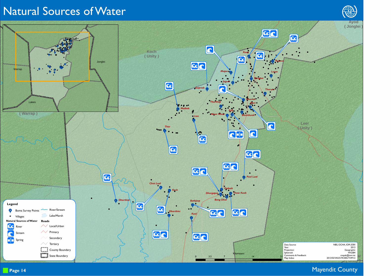
Mayendit County
LPU
RiverStream
Spring
Natural Sources of Water
Page 14
Data Source:Year:Projection:Spheroid:Comments & Feedback:Map Index:
NBS, OCHA, IOM, ESRI2013
GeographicWGS84
[email protected]/SS/VAS/S19C005/THM12
Natural Sources of Water
999
9999
9
999999
9
9
99
9
9
9
9999
99
9
Lakes
Jonglei
Warrap
0 7 14 213.5Kilometers

Panyijar( Unity )
Leer( Unity )
Koch( Unity )
Tonj East( Warrap )
Tonj North( Warrap ) Ayod
( Jonglei )
Dhorthier
Bathjiop
Kuol
PadeahBang Dhol
Thow Kuok
Puol Lual
Dhorgapni
Rieri
Biemthuok
Dhorlek
KahTharthep
Nhiar Nhiar
Luom
Thoryiel
KechDhorthier
Chot Lual
Kangkoi
Rubnor
JaguarGapriak
Maper
Kuok
Lian
Thor
Malbek
MM
U M
U M
M
M
XM X
M
M
M
M
U
M
Legend9 Boma Survey Points
VillagesAccess to Water Source
Easy
Medium
DifficultRiver/Stream
Lake/MarshRoads
Local/UrbanPrimarySecondaryTertiaryCounty BoundaryState Boundary
Mayendit County
Hom
Water Points and Physical Accessibility
UMXkY
Borehole
HafirTap
Water Tanker
Page 15
Data Source:Year:Projection:Spheroid:Comments & Feedback:Map Index:
NBS, OCHA, IOM, ESRI2013
GeographicWGS84
[email protected]/SS/VAS/S19C005/THM13
Sources of Water
999
9999
9
999999
99
99
9
99
9999
99
9
Lakes
Jonglei
Warrap
0 7.5 15 22.53.75Kilometers

9
9
9
9
99
9
9
99
9
9
9
9
9
9
9
9
9
9
9
9
9
9
9
9
9
9
Leer( Unity )
Koch( Unity )
Tonj East( Warrap )
Tonj North( Warrap )
Ayod( Jonglei )
Dhorthier
Bathjiop
Kuol
Padeah
Bang Dhol
Thow Kuok
Puol Lual
Dhorgapni
RieriBiemthuok
Dhorlek
Kah
Tharthep
Nhiar Nhiar
Luom
Thoryiel
Kech
Dhorthier
Chot Lual
Kangkoi
Rubnor
JaguarGapriak
Maper
Kuok
Lian
Thor
Malbek
D
D
>D
>D
>D>D
>D
D
>D
D
>[ D
D
>[
>D
D
D
D
D
>[
>
Legend9 Boma Survey Points
VillagesRiver/StreamLake/Marsh
RoadsLocal/UrbanPrimarySecondaryTertiaryCounty BoundaryState Boundary
Water Management and Related Conflicts
Mayendit County
>[D
Water User CommitteeWater FeeConflict for Water
Page 16
Data Source:Year:Projection:Spheroid:Comments & Feedback:Map Index:
NBS, OCHA, IOM, ESRI2013
GeographicWGS84
[email protected]/SS/VAS/S19C008/THM14
999
999
9
9
999999
9
9
99
9
9
9
99
9
9
99
9
Lakes
Jonglei
Warrap
0 7 14 213.5Kilometers

9
9
9
999
9
9
99
9
999
9
9
99
9
9
9
99
9
9
99
9
RumbekNorth
( Lakes )
Panyijar( Unity )
Leer( Unity )
Koch( Unity )
Tonj East( Warrap )
Tonj North( Warrap )
Duk( Jonglei )
Ayod( Jonglei )
Fangak( Jonglei )
Dhorthier
Bathjiop
Kuol
Padeah
Bang DholThow Kuok
Puol Lual
Dhorgapni
Rieri
Biemthuok
Dhorlek
Kah
Tharthep
Nhiar Nhiar
Luom
Thoryiel
Kech
Dhorthier
Chot Lual
Kangkoi
Rubnor
JaguarGapriak
Maper
Kuok
LianThor
Malbek
R PR P
R P
R P S T
R P S T
R P S T
R P S T
R PR P
R P S
Legend9 Boma Survey Points
VillagesRiver/StreamLake/Marsh
RoadsLocal/UrbanPrimarySecondaryTertiaryCounty BoundaryState Boundary
Water, Sanitation and Hygiene Education
Mayendit County
RPST
Hand Washing
Clean Drinking Water
Good Hygiene
Garbage Disposal
Page 17
Data Source:Year:Projection:Spheroid:Comments & Feedback:Map Index:
NBS, OCHA, IOM, ESRI2013
GeographicWGS84
[email protected]/SS/VAS/S19C008/THM15
WASH Education Topics
0 10 20 305Kilometers

RumbekNorth
( Lakes )
Panyijar( Unity )
Leer( Unity )
Koch( Unity )
Tonj East( Warrap )
Tonj North( Warrap )
Duk( Jonglei )
Ayod( Jonglei )
Fangak( Jonglei )
DhorthierBathjiop
Kuol
Padeah
Bang DholThow Kuok
Puol Lual
Dhorgapni
RieriBiemthuok
Dhorlek
KahTharthepNhiar Nhiar
Luom
Thoryiel
KechDhorthier
Chot Lual
Kangkoi
Rubnor
JaguarGapriak
Maper
Kuok
LianThor
Malbek
Ó
Ó
Ó
Ó
Ó
LegendPresence of Latrine & Use
Not PresentPresent & Not usedPresent & Not SpecifiedPresent & UsedVillages
River/StreamLake/Marsh
RoadsLocal/UrbanPrimarySecondaryTertiaryCounty BoundaryState Boundary
Latrine Types and Use
Mayendit County
NOÓ
Public Latrines
Private Latrines
Open Air
Page 18
Data Source:Year:Projection:Spheroid:Comments & Feedback:Map Index:
NBS, OCHA, IOM, ESRI2013
GeographicWGS84
[email protected]/SS/VAS/S19C008/THM160 10 20 305
Kilometers

RumbekNorth
( Lakes )
Panyijar( Unity )
Leer( Unity )
Koch( Unity )
Tonj East( Warrap )
Tonj North( Warrap )
Duk( Jonglei )
Ayod( Jonglei )
Fangak( Jonglei )
Dhorthier
Bathjiop
Kuol
Padeah
Bang Dhol
Thow Kuok
Puol Lual
Dhorgapni
RieriBiemthuok
Dhorlek
Kah
Tharthep
Nhiar Nhiar
Luom
Thoryiel
KechDhorthier Chot Lual
Kangkoi
Rubnor
JaguarGapriak
Maper
Kuok
LianThor
Malbek
Legend
H Education facility
9 Boma Survey PointsVillages
Acces to Education facilityEasy
Medium
Difficult
River/StreamLake/Marsh
RoadsLocal/UrbanPrimarySecondaryTertiaryCounty BoundaryState Boundary
Access to Education Facilities
Mayendit County Page 19
Data Source:Year:Projection:Spheroid:Comments & Feedback:Map Index:
NBS, OCHA, IOM, ESRI2013
GeographicWGS84
[email protected]/SS/VAS/S19C008/THM170 10 20 305
Kilometers
Payam No of Boma Bomas with Education Facility Number of Education FacilityRubkuay 3 3 3Dablual 6 4 4Tharjiath Bor 3 1 1Luom 2 2 3Thaker 3 1 2Mal 3 1 1Bor 5 1 1Babuong 3 1 1Education facilities shown in RED are in open air or with temporary structures.

9
9
9
9
99
9
9
9
9
9
9
9
9
9
9
9
9
9
9
9
9
9
9
9
9
9
9
!3
!5
!5 !8
!4!5
!8!5
!4
!5
!4
!3
!4 !5
!4
!8
!5
Leer( Unity )
Koch( Unity )
Ayod( Jonglei )
Dhorthier
Bathjiop
Kuol
Padeah
Bang Dhol
Thow Kuok
Puol Lual
Dhorgapni
RieriBiemthuok
Dhorlek
Kah
Tharthep
Nhiar Nhiar
Luom
Thoryiel
Kech
Dhorthier
Chot Lual
Kangkoi
Rubnor
Jaguar
Gapriak
Maper
Kuok
Lian
Thor
Malbek
.. .
.
. .
. . .
.. . .
. .
. .
. ..
. .
. .
. . .
. .
. .
Legend9 Boma Survey Points
VillagesLevel Of Education!3 Highest standard taught!! Not specified
River/StreamLake/Marsh
RoadsLocal/UrbanPrimarySecondaryTertiaryCounty BoundaryState Boundary
Level of Education and Medium of Instruction
Mayendit County
.
.
.
ArabicEnglishLocal Language
Page 20
Data Source:Year:Projection:Spheroid:Comments & Feedback:Map Index:
NBS, OCHA, IOM, ESRI2013
GeographicWGS84
[email protected]/SS/VAS/S18C008/THM18
Medium of Instruction
&(
&( &(
&(&(
&(&(
&(
&(&(
&(&(&(
&(&(
&(
Lakes
Jonglei
Warrap
0 5 10 152.5Kilometers
Old Sudan, 1 New South Sudan, 15
0% 20% 40% 60% 80% 100%
Curric
ulum
Payam Below standard 4
Up to standard 4
Up to standard 5
Up to standard 6
Up to standard 7
Up to standard 8
Not specified
Grand Total
Rubkuay 0 0 2 0 0 1 0 3Dablual 0 1 2 0 0 1 0 4Tharjiath Bor 0 1 0 0 0 0 0 1Luom 1 1 1 0 0 0 0 3Thaker 0 1 1 0 0 0 0 2Mal 0 1 0 0 0 0 0 1Bor 0 0 0 0 0 1 0 1Babuong 0 0 1 0 0 0 0 1

9
9
9
999
9
9
99
9
999
9
9
99
9
9
9
99
9
9
99
9
RumbekNorth
( Lakes )
Panyijar( Unity )
Leer( Unity )
Koch( Unity )
Tonj East( Warrap )
Tonj North( Warrap )
Duk( Jonglei )
Ayod( Jonglei )
Fangak( Jonglei )
DhorthierBathjiop
Kuol
Padeah
Bang Dhol
Thow Kuok
Puol Lual
Dhorgapni
Rieri
Biemthuok
Dhorlek
Kah
Tharthep
Nhiar Nhiar
Luom
Thoryiel
KechDhorthier
Chot Lual
Kangkoi
Rubnor
JaguarGapriak
Maper
Kuok
LianThor
Malbek
Legend9 Boma Survey Points
VillagesTeacher to Student Ratio
1 Teacher per 70 Students1 Teacher per 35 Students
1 Teacher per 15 Students
1 Teacher per 5 StudentsRiver/StreamLake/Marsh
RoadsLocal/UrbanPrimarySecondaryTertiaryCounty BoundaryState Boundary
Teacher to Student Ratio
Mayendit County Page 21
Data Source:Year:Projection:Spheroid:Comments & Feedback:Map Index:
NBS, OCHA, IOM, ESRI2013
GeographicWGS84
[email protected]/SS/VAS/S19C008/THM190 10 20 305
Kilometers
Male10491%
Female109%
Male-Female Teachers in Primary Schools

9
9
9
9
99
9
9
99
9
9
9
9
9
9
9
9
9
9
9
9
9
9
9
9
9
9
Leer( Unity )
Koch( Unity )
Tonj East( Warrap )
Tonj North( Warrap )
Ayod( Jonglei )
Dhorthier
Bathjiop
Kuol
PadeahBangDhol
ThowKuok
PuolLual
Dhorgapni
RieriBiemthuok
Dhorlek
Kah
Tharthep
NhiarNhiar
Luom
Thoryiel
Kech
Dhorthier
ChotLual
Kangkoi
Rubnor
JaguarGapriak
Maper
Kuok
Lian
Thor
Malbek
(
( Q (
((
(
(
Q (
(
(
(
( (
(
(
Q (Legend9 Boma Survey Points
VillagesEducation FacilityRiver/StreamLake/Marsh
RoadsLocal/UrbanPrimarySecondaryTertiary
County BoundaryState Boundary
Primary School Facilities
Mayendit County
W*Qy
Separate Toilets for Boys & GirlsEnrollment of Personswith DisabilitiesPotable Water
Play AreaFirst-Aid Equipment
(Parent-Teacher Association
Page 22
Data Source:Year:Projection:Spheroid:Comments & Feedback:Map Index:
NBS, OCHA, IOM, ESRI2013
GeographicWGS84
[email protected]/SS/VAS/S19C008/THM20
Facilities offered
&(
&(&(
&(&(&(&(
&(
&(&(
&(&(&(
&(&(
&(
Lakes
JongleiWarrap
0 6 12 183Kilometers

9
9
9
9
99
9
9
99
9
9
9
9
9
9
9
9
9
9
9
9
9
9
9
9
9
9
Leer( Unity )
Koch( Unity )
Tonj East( Warrap )
Tonj North( Warrap )
Dhorthier
Bathjiop
Kuol
Padeah
Bang Dhol
Thow Kuok
Puol Lual
Dhorgapni
RieriBiemthuok
Dhorlek
Kah
Tharthep
Nhiar Nhiar
Luom
Thoryiel
Kech
Dhorthier
Chot Lual
Kangkoi
Rubnor
Jaguar
Gapriak
Maper
Kuok
Lian
Thor
Malbek
( r q
(
( q
( r
(
(
(
( r q
(( q
(
( q( r q
( r q
(
(
r
( r
( r
( r(
(
(
( r
Legend9 Boma Survey Points
VillagesRiver/StreamLake/Marsh
RoadsLocal/UrbanPrimarySecondaryTertiaryCounty BoundaryState Boundary
Presence of Rule of Law Institutions
Mayendit County
(rq
Boma Court
Police Station
Judicial Court
Page 23
Data Source:Year:Projection:Spheroid:Comments & Feedback:Map Index:
NBS, OCHA, IOM, ESRI2013
GeographicWGS84
[email protected]/SS/VAS/S19C008/THM21
999
9999
9
999999
9
9
99
9
9
9
99
99
99
9
Lakes
Jonglei
Warrap
0 6 12 183Kilometers

9
9
9
9
99
9
9
99
9
9
9
9
9
9
9
9
9
9
9
9
9
9
9
9
9
9
Leer( Unity )
Koch( Unity )
Tonj East( Warrap )
Tonj North( Warrap )
Dhorthier
Bathjiop
Kuol
Padeah
Bang Dhol
Thow Kuok
Puol Lual
Dhorgapni
RieriBiemthuok
Dhorlek
Kah
Tharthep
Nhiar Nhiar
Luom
Thoryiel
Kech
Dhorthier
Chot Lual
Kangkoi
Rubnor
Jaguar
Gapriak
Maper
Kuok
Lian
Thor
Malbek
u z h w
u z h w
u z h w
D uh w
D uh w
D u z h w
D u z h w
u z h w
u zh w
D u zh w
D u zh w
D u zh w
u z h w
u w
D u z w
D zD z w
D u zh w
u z h w
u z h w
u h w
u z h w
D h w
D h w
h w
Legend9 Boma Survey Points
VillagesRiver/StreamLake/Marsh
RoadsLocal/UrbanPrimarySecondaryTertiaryCounty BoundaryState Boundary
Mayendit County
Duzhw
Armed ConflictDrought
Flood
HungerEpidemics
External Threats, Violations and Risks
Page 24
Data Source:Year:Projection:Spheroid:Comments & Feedback:Map Index:
NBS, OCHA, IOM, ESRI2013
GeographicWGS84
[email protected]/SS/VAS/S19C008/THM22
External Threats
999
9999
9
999999
9
9
99
9
9
9
9999
99
9
Lakes
Jonglei
Warrap
0 6 12 183Kilometers

9
9
9
9
99
9
9
99
9
9
9
9
9
9
9
9
9
9
9
99
9
9
9
9
9
Panyijar( Unity )
Leer( Unity )
Koch( Unity )
Tonj East( Warrap )
Tonj North( Warrap ) Ayod
( Jonglei )
Dhorthier
Bathjiop
Kuol
Padeah
Bang Dhol
Thow Kuok
Puol Lual
Dhorgapni
Rieri
Biemthuok
Dhorlek
Kah
Tharthep
Nhiar Nhiar
Luom
Thoryiel
Kech
Dhorthier
Chot Lual
Kangkoi
Rubnor
JaguarGapriak
Maper
Kuok
Lian
Thor
Malbek
D $ % W I U D $ % W I U
D $ % W I U
D $ % W I UD $ % W I U
D $ I UD $ I U
D $ % W I U
$
D $ I U
$ U
D $ % I U
D $ % W ID $ % W I U
$ I U
W I U
I U
D $ % I U
D $ I U
D $ I U
Legend9 Boma Survey Points
VillagesRiver/StreamLake/Marsh
RoadsLocal/UrbanPrimarySecondaryTertiaryCounty BoundaryState Boundary
Mayendit County
D$%WIU
Local Conflict
Domestic Violence
SGBV*Seasonal Road Access
Crop Disease
Livestock Disease
Internal Threats, Violations and Risks
Page 25
Data Source:Year:Projection:Spheroid:Comments & Feedback:Map Index:
NBS, OCHA, IOM, ESRI2013
GeographicWGS84
[email protected]/SS/VAS/S19C008/THM23
Internal Threats
*SGBV: Sexual and Gender Based Violence
999
999
9
9
999999
9
9
99
9
9
9
99
9
9
99
9
Lakes
Jonglei
Warrap
0 7.5 15 22.53.75Kilometers

This page is intentionally left blank