Vicmap Admin Product Description - Department of ... DESCRIPTION Information Services Division...
57
PRODUCT DESCRIPTION VICMAP ADMIN INCORPORATING : Victorian Local Government Boundaries Victorian Locality Boundaries Victorian Postcode Boundaries Victorian Township and Parish Boundaries Victorian Electoral Boundaries Victorian Local Government Ward Boundaries Victorian Government Regional Departmental Boundaries Department of Environment, Land, Water and Planning Regional Boundaries CFA Regions, Districts and Total Fire Ban Districts MFB Regions and Districts Disclaimer Information Services Division does not warrant that this Product Description and the data are free from errors or omissions. Also, Information Services Division shall not be in any way liable for any loss, damage or injury suffered by the licensed user of the data of this Product Description or any other person or organisation consequent upon or incidental to the existence of errors or omissions in the data or this Product Description. Information Services Division Department of Environment, Land, Water and Planning Document version 2.7 - Aug 2016
Transcript of Vicmap Admin Product Description - Department of ... DESCRIPTION Information Services Division...
PRODUCT DESCRIPTION
VICMAP ADMIN
INCORPORATING :
Victorian Local Government Boundaries
Victorian Locality Boundaries
Victorian Postcode Boundaries
Victorian Township and Parish Boundaries
Victorian Electoral Boundaries
Victorian Local Government Ward Boundaries
Victorian Government Regional Departmental Boundaries
Department of Environment, Land, Water and Planning Regional Boundaries
CFA Regions, Districts and Total Fire Ban Districts
MFB Regions and Districts
Disclaimer
Information Services Division does not warrant that this Product Description and the data are free from errors or omissions. Also, Information Services Division shall not be in any way liable for any loss, damage or injury suffered by the licensed user of the data of this Product Description or any other person or organisation consequent upon or incidental to the existence of errors or omissions in the data or this Product Description.
Information Services Division
Department of Environment, Land, Water and Planning
Document version 2.7 - Aug 2016
PRODUCT DESCRIPTION Information Services Division Vicmap Admin Department of Environment, Land, Water and Planning Version 2.7
1
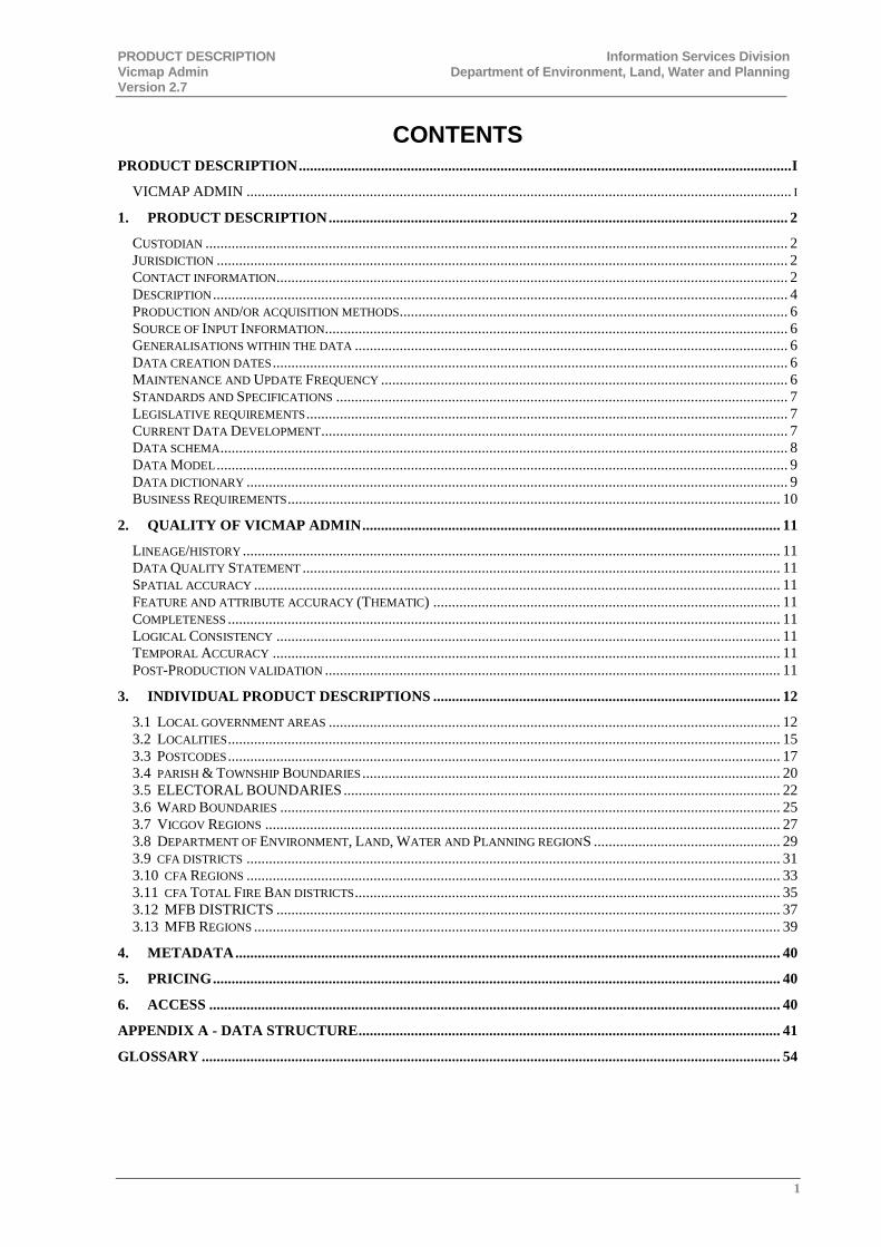
CONTENTS
PRODUCT DESCRIPTION .................................................................................................................................... I
VICMAP ADMIN .................................................................................................................................................. I
1. PRODUCT DESCRIPTION ........................................................................................................................... 2
CUSTODIAN ............................................................................................................................................................ 2 JURISDICTION ......................................................................................................................................................... 2 CONTACT INFORMATION......................................................................................................................................... 2 DESCRIPTION .......................................................................................................................................................... 4 PRODUCTION AND/OR ACQUISITION METHODS ........................................................................................................ 6 SOURCE OF INPUT INFORMATION ............................................................................................................................ 6 GENERALISATIONS WITHIN THE DATA .................................................................................................................... 6 DATA CREATION DATES .......................................................................................................................................... 6 MAINTENANCE AND UPDATE FREQUENCY ............................................................................................................. 6 STANDARDS AND SPECIFICATIONS ......................................................................................................................... 7 LEGISLATIVE REQUIREMENTS ................................................................................................................................. 7 CURRENT DATA DEVELOPMENT ............................................................................................................................. 7 DATA SCHEMA ........................................................................................................................................................ 8 DATA MODEL ......................................................................................................................................................... 9 DATA DICTIONARY ................................................................................................................................................. 9 BUSINESS REQUIREMENTS .................................................................................................................................... 10
2. QUALITY OF VICMAP ADMIN ................................................................................................................ 11
LINEAGE/HISTORY ................................................................................................................................................ 11 DATA QUALITY STATEMENT ................................................................................................................................ 11 SPATIAL ACCURACY ............................................................................................................................................. 11 FEATURE AND ATTRIBUTE ACCURACY (THEMATIC) ............................................................................................. 11 COMPLETENESS .................................................................................................................................................... 11 LOGICAL CONSISTENCY ....................................................................................................................................... 11 TEMPORAL ACCURACY ........................................................................................................................................ 11 POST-PRODUCTION VALIDATION .......................................................................................................................... 11
3. INDIVIDUAL PRODUCT DESCRIPTIONS ............................................................................................. 12
3.1 LOCAL GOVERNMENT AREAS ......................................................................................................................... 12 3.2 LOCALITIES .................................................................................................................................................... 15 3.3 POSTCODES .................................................................................................................................................... 17 3.4 PARISH & TOWNSHIP BOUNDARIES ................................................................................................................ 20 3.5 ELECTORAL BOUNDARIES ..................................................................................................................... 22 3.6 WARD BOUNDARIES ...................................................................................................................................... 25 3.7 VICGOV REGIONS .......................................................................................................................................... 27 3.8 DEPARTMENT OF ENVIRONMENT, LAND, WATER AND PLANNING REGIONS .................................................. 29 3.9 CFA DISTRICTS ............................................................................................................................................... 31 3.10 CFA REGIONS ............................................................................................................................................... 33 3.11 CFA TOTAL FIRE BAN DISTRICTS .................................................................................................................. 35 3.12 MFB DISTRICTS ....................................................................................................................................... 37 3.13 MFB REGIONS ............................................................................................................................................. 39
4. METADATA .................................................................................................................................................. 40
5. PRICING ........................................................................................................................................................ 40
6. ACCESS ......................................................................................................................................................... 40
APPENDIX A - DATA STRUCTURE ................................................................................................................. 41
GLOSSARY ........................................................................................................................................................... 54
PRODUCT DESCRIPTION Information Services Division Vicmap Admin Department of Environment, Land, Water and Planning Version 2.7
2
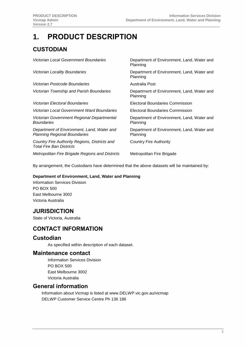
1. PRODUCT DESCRIPTION
CUSTODIAN
Victorian Local Government Boundaries Department of Environment, Land, Water and Planning
Victorian Locality Boundaries Department of Environment, Land, Water and Planning
Victorian Postcode Boundaries Australia Post
Victorian Township and Parish Boundaries Department of Environment, Land, Water and Planning
Victorian Electoral Boundaries Electoral Boundaries Commission
Victorian Local Government Ward Boundaries Electoral Boundaries Commission
Victorian Government Regional Departmental Boundaries
Department of Environment, Land, Water and Planning
Department of Environment, Land, Water and Planning Regional Boundaries
Department of Environment, Land, Water and Planning
Country Fire Authority Regions, Districts and Total Fire Ban Districts
Country Fire Authority
Metropolitan Fire Brigade Regions and Districts Metropolitan Fire Brigade
By arrangement, the Custodians have determined that the above datasets will be maintained by:
Department of Environment, Land, Water and Planning
Information Services Division
PO BOX 500
East Melbourne 3002
Victoria Australia
JURISDICTION State of Victoria, Australia
CONTACT INFORMATION
Custodian As specified within description of each dataset.
Maintenance contact Information Services Division
PO BOX 500
East Melbourne 3002
Victoria Australia
General information Information about Vicmap is listed at www.DELWP.vic.gov.au/vicmap
DELWP Customer Service Centre Ph 136 186
PRODUCT DESCRIPTION Information Services Division Vicmap Admin Department of Environment, Land, Water and Planning Version 2.7
3
Supply enquiries Vicmap Products are available through:
the DataVic access policy http://www.data.vic.gov.au/
for purchase of small packets/areas of selected products online, go to www.depi.vic.gov.au/vicmapdata
or
for larger quantities of Vicmap, refer to one of our Data Service Providers, listed at www.depi.vic.gov.au/vicmapdsp
E-mail enquiries [email protected]
Internet site for information http://www.depi.vic.gov.au/vicmap
PRODUCT DESCRIPTION Information Services Division Vicmap Admin Department of Environment, Land, Water and Planning Version 2.7
4
DESCRIPTION Vicmap Admin comprises several individual datasets. Each is topologically structured and models all designated and gazetted boundaries across the whole of Victoria.
Geographic extent Vicmap Admin content covers the entire state of Victoria.
Content The Vicmap Admin product records administrative boundaries as defined by the Custodian. These attributes are detailed in the data descriptions of each dataset.
Structure The Vicmap Admin spatial data set consists of a series of polygons depicting administrative boundaries, which in turn, define a statewide coverage of contiguous non-overlapping polygons. In combination these polygons represent the entire administration area of Victoria.
Line and point data will not be included in the present structure of the Vicmap Admin data set.
More information on Structure is detailed in the data descriptions of each dataset.
Features Vicmap Admin is intended to accurately record the location of the boundaries represented. This means that changes occur on an irregular basis in response to administrative boundary reviews conducted by the respective Custodian, or as a result of errors being detected in the data. Features of note include:
There are two versions each of the LGA and Locality datasets within Vicmap Admin. One is aligned to property features and one to topographic. More information is provided in the data descriptions of the LGA and Locality datasets.
Persistent Feature Identifier (pfi) - each admin boundary polygon is uniquely identified for easier management. A persistent feature identifier remains unchanged for the life of the admin boundary polygon.
Unique Feature Identifier (ufi) – each admin boundary polygon is uniquely identified for easier management. The unique feature identifier changes whenever an admin boundary record attribute is changed.
Temporal Data Management. Vicmap data is never deleted, only retired. Key features are tagged with the following attributes to enable an audit trail to be maintained:
- PFI_ created -
- UFI_created - (format dd-mm-yyyy hh:mm:ss) is the date/time stamped against each feature when its UFI is created.
The exception to the above rules is those datasets maintained by VEC which do not contain PFI’s and UFI’s.
Updates provided as whole file replacement.
More information on Features of Note is detailed in the data descriptions of each dataset.
Reference systems The datum used in the construction and maintenance of Vicmap data is the Geocentric Datum of Australia. Data is held in geographicals (latitude/longitude) computed in terms of the GDA at 01 January 1994 (GDA94).
PRODUCT DESCRIPTION Information Services Division Vicmap Admin Department of Environment, Land, Water and Planning Version 2.7
5
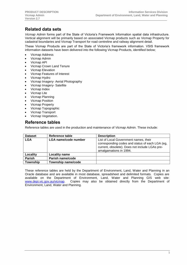
Related data sets Vicmap Admin forms part of the State of Victoria’s Framework Information spatial data infrastructure. Vertical alignment will be primarily based on associated Vicmap products such as Vicmap Property for cadastral boundaries and Vicmap Transport for road centreline and railway alignment detail.
These Vicmap Products are part of the State of Victoria’s framework information. VSIS framework information datasets have been delivered into the following Vicmap Products, identified below;
Vicmap Address
Vicmap Admin
Vicmap API
Vicmap Crown Land Tenure
Vicmap Elevation
Vicmap Features of Interest
Vicmap Hydro
Vicmap Imagery- Aerial Photography
Vicmap Imagery- Satellite
Vicmap Index
Vicmap Lite
Vicmap Planning
Vicmap Position
Vicmap Property
Vicmap Topographic
Vicmap Transport
Vicmap Vegetation.
Reference tables Reference tables are used in the production and maintenance of Vicmap Admin. These include:
Dataset Reference table Description
LGA LGA name/code number List of Local Government names, their corresponding codes and status of each LGA (eg, current, obsolete). Does not include LGAs pre-amalgamations in 1994.
Locality Locality name
Parish Parish name/code
Township Township name/code
These reference tables are held by the Department of Environment, Land, Water and Planning in an Oracle database and are available in most database, spreadsheet and delimited formats. Copies are available on the Department of Environment, Land, Water and Planning GIS web site: www.depi.vic.gov.au/vicmap. Copies may also be obtained directly from the Department of Environment, Land, Water and Planning.
PRODUCT DESCRIPTION Information Services Division Vicmap Admin Department of Environment, Land, Water and Planning Version 2.7
6
PRODUCTION AND/OR ACQUISITION METHODS See individual descriptions for more information relating to each dataset.
Vicmap Admin clearly defines administrative boundaries in terms of their underlying spatial features, such as property boundaries, railway lines, creek banks and road centrelines.
Vicmap Admin is a component part of the Vicmap suite of Victoria-wide Framework Information products. Vertical alignment with underlying property or transport data is a priority and wherever possible has been achieved. Variation or non-alignment occurs due to data origins, and/or the differing nature of content, and/or the requirements and constraints at the time of construction of the datasets. For example, the origin of much topographic data is the State’s 1:25,000 standard mapping program and the origin of much cadastral data varies from direct input survey co-ordinates to 1:25,000 property/parcel mapping. Other issues relate to temporal factors. For example, the topographic representation of a stream bank in Vicmap Hydro will be what exists today; the cadastral representation of the same stream bank in Vicmap Property will be what was surveyed at the time of alienation. Whilst observation has shown that the alignment of the same or similar features across these data sets is extraordinarily good, scale variation, temporal issues and feature definition will result in variance in many cases. Whilst full vertical alignment is being targeted by the Department of Environment, Land, Water and Planning, these manifold issues will delay its final achievement.
Whilst these alignment issues are being attended to, the difficulty to the Department of Environment, Land, Water and Planning and Vicmap users is the need for two versions of the same Vicmap Admin data. One version will be aligned to the cadastre (Vicmap Property) and the other aligned to topographic features (Vicmap Transport, Vicmap Hydro, etc). In many cases, the two versions will be the same, or similar, however there may be differences due to those fundamental variations highlighted above. Users should be aware of these issues and decide which version they need or whether for their purposes, the differences will be insignificant.
Those Vicmap Admin datasets duplicated presently include Victorian Local Government Boundaries and Victorian Locality Boundaries. The remaining Vicmap Admin datasets have been aligned mainly to Vicmap Property.
SOURCE OF INPUT INFORMATION See individual descriptions for more information relating to each dataset.
GENERALISATIONS WITHIN THE DATA Vicmap Admin has not been generalised, however more information is provided in the individual descriptions where necessary.
DATA CREATION DATES Data is never deleted, only retired. All key features are tagged with the following attributes to enable an audit trail to be maintained and to facilitate incremental updating:
‘pfi_created’ (format dd-mm-yyyy hh:mm:ss) is the date/time stamped against each feature when it is created.
‘UFI_created’ (format dd-mm-yyyy hh:mm:ss) is the date/time stamped against each feature when its UFI is created.
MAINTENANCE AND UPDATE FREQUENCY See individual descriptions for more information relating to each dataset.
PRODUCT DESCRIPTION Information Services Division Vicmap Admin Department of Environment, Land, Water and Planning Version 2.7
7
STANDARDS AND SPECIFICATIONS All Vicmap Admin datasets comply with the standards outlines in the dataset’s metadata record.
Conformity is sought with relevant portions of proposed (draft) standards and specifications. For example:
Relevant Australian (AS) standards.
ISO 19100 series as they become adapted by Standards Australia and the user community.
The outputs of Working Groups under the auspices of ICSM, ANZLIC and other industry organisations.
ISD has adopted the recommended ICSM Guidelines for incremental update (Ref. Policy and Guidelines for Incremental Update – ICSM Harmonisation Working Group, October 2000).
Where these Standards have been found to be inadequate for ISD requirements, e.g. attribute field size insufficient, suitable modifications have been made.
LEGISLATIVE REQUIREMENTS LGA Boundaries are defined under the requirements of the Local Government Act 1989.
Locality boundaries are defined under the requirements of the Geographic Place Names Act 1998.
There are no known legislative requirements for the establishment or maintenance of postcode boundaries.
Parish boundaries are not defined under any legislation. The exception to this is 13 parishes that were proclaimed and these were all in the 1800's. This was under the Land Act that was current at the time.
Township boundaries are proclaimed under the Land Act current at the time. At present the current land act is Land Act 1958. Any new townships would be proclaimed under this Act.
Electoral Boundaries are defined under the requirements of the Electoral Boundaries Commission Act 1982.
Ward boundaries are defined under the requirements of the Local Government Act 1989.
Victorian government regions are not defined under legislation. This dataset was created by the (former) Department for Victorian communities through "A Fairer Victoria" policy released April 2005. The boundaries were activated on 1 July 2005.
CURRENT DATA DEVELOPMENT Vicmap Admin will be further enhanced and developed through the implementation of the following projects:
Integration with other Vicmap datasets: As part of the Department of Environment, Land, Water and Planning spatial framework data strategy, work will continue to more closely integrate all Vicmap products. For Vicmap Admin, this will mean that each administrative boundary will have existing data generalisations removed and will be fully aligned to its defining underlying feature (e.g. property boundary, road or railway centreline, coast or water feature) as delineated in its related Vicmap framework data set.
Notification for Edit Service: The Notification for Edit Service (NES) is an initiative that is crucial to supporting government delivery outcomes by providing ubiquitous access to authoritative location based services across business for users of all levels of expertise. The objectives of NES are to:
Improve spatial data quality Provide simple, efficient, effective, low cost maintenance processes Create a fully transparent maintenance process for all participants Enable maintenance process availability to any potential maintainer
The NES application had its first release in July 2008 to selected customers. Further information can be directed to Manager Vicmap [email protected]

PRODUCT DESCRIPTION Information Services Division Vicmap Admin Department of Environment, Land, Water and Planning Version 2.7
8
DATA SCHEMA
Data structure Vicmap Admin represents the extent of administrative areas as defined by the Custodian.
The object types below are the primitive component of data contained in Vicmap Admin.
POLYGON
A bounded, continuous region consisting of an interior area and an outer boundary defined by a set of lines.
Within Vicmap Admin there will be no complex polygons, i.e. nested polygons, inner rings or ‘donuts’.
Spatial Data Integrity The spatial data will have no overshoots, undershoots, broken lines or other artefacts of the data capture process as illustrated below. Topology will be fully and correctly established. All polygons will close.
Undershoot in data:
Correct Representation Incorrect Representation
Overshoot in data:
Correct Representation Incorrect Representation
Broken line in data:
Correct Representation
Incorrect Representation
PRODUCT DESCRIPTION Information Services Division Vicmap Admin Department of Environment, Land, Water and Planning Version 2.7
9
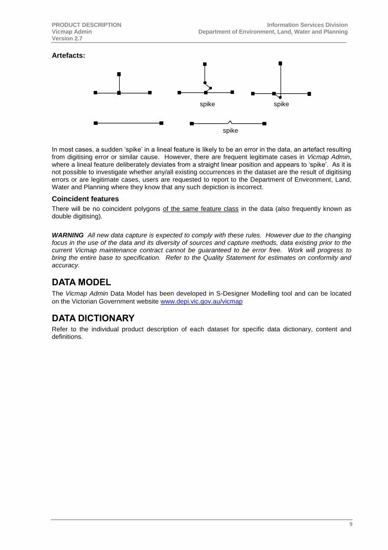
Artefacts:
spike spike
spike
In most cases, a sudden ‘spike’ in a lineal feature is likely to be an error in the data, an artefact resulting from digitising error or similar cause. However, there are frequent legitimate cases in Vicmap Admin, where a lineal feature deliberately deviates from a straight linear position and appears to ‘spike’. As it is not possible to investigate whether any/all existing occurrences in the dataset are the result of digitising errors or are legitimate cases, users are requested to report to the Department of Environment, Land, Water and Planning where they know that any such depiction is incorrect.
Coincident features
There will be no coincident polygons of the same feature class in the data (also frequently known as double digitising).
WARNING All new data capture is expected to comply with these rules. However due to the changing focus in the use of the data and its diversity of sources and capture methods, data existing prior to the current Vicmap maintenance contract cannot be guaranteed to be error free. Work will progress to bring the entire base to specification. Refer to the Quality Statement for estimates on conformity and accuracy.
DATA MODEL The Vicmap Admin Data Model has been developed in S-Designer Modelling tool and can be located
on the Victorian Government website www.depi.vic.gov.au/vicmap
DATA DICTIONARY Refer to the individual product description of each dataset for specific data dictionary, content and definitions.
PRODUCT DESCRIPTION Information Services Division Vicmap Admin Department of Environment, Land, Water and Planning Version 2.7
10
BUSINESS REQUIREMENTS
Exclusion of Liability Information Services Division makes every effort to provide and maintain accurate, complete, useable and timely digital land information. However, some product versions may be preliminary in nature and presented prior to final review and approval by the Director of ISD. The data and information are provided with the understanding that they are not guaranteed to be correct or complete. Users are cautioned to consider carefully the provisional nature of the data before using it for decisions that concern personal or public safety or the conduct of business that involves substantial monetary or operational consequences. Conclusions drawn from, or actions undertaken on the basis of this data are the sole responsibility of the user.
ISD does not warrant that this Product Description and the data are free from errors or omissions. Also, ISD shall not be in any way liable for any loss, damage or injury suffered by the licensed user of the data of this Product Description or any other person or organisation consequent upon or incidental to the existence of errors or omissions in the data or this Product Description.
Supply format ESRI ‘SHAPE’ files
MapInfo
Other formats upon application
Media format
CD-ROM and DVD
Other formats and media available upon application
Projections Native projection - Geocentric Datum of Australia – 1994 Adjustment (GDA94)
Degrees and decimals of a degree - GDA94 latitude/longitude
Others on request
Areas of application Strategic planning
Valuation analysis
Project planning
Reference frameworks
Graphic Index
Integration with other Vicmap datasets
Demographic studies
Spatial analysis of address files
PRODUCT DESCRIPTION Information Services Division Vicmap Admin Department of Environment, Land, Water and Planning Version 2.7
11
2. QUALITY OF VICMAP ADMIN
LINEAGE/HISTORY Refer to individual descriptions of each dataset.
DATA QUALITY STATEMENT
Fitness for purpose The use of this data is logically suited to applications geared towards analysis of data using the appropriate dataset (eg, Local Government Area, Postcodes, Electoral districts, etc).
SPATIAL ACCURACY The accuracy of these datasets has not been specifically determined. Where they align with underlying elements in related Vicmap products such as Vicmap Property or Vicmap Transport, the accuracy will be that of the underlying feature.
FEATURE AND ATTRIBUTE ACCURACY (THEMATIC) For this product, feature and attribute accuracy is a measure of the degree to which the features and attribute values of spatial objects agree with the information on the source material. The maximum allowable error in attribute accuracy is 1%.
COMPLETENESS The reliability figures indicating completeness of content between the dataset and the source material is 99%.
LOGICAL CONSISTENCY Logical consistency is a measure of the degree to which data complies with the technical specification. The maximum allowable error in logical consistency is 1% for maintenance activity. The test procedures are a mixture of software scripts and on-screen, visual checks.
TEMPORAL ACCURACY Refer to each Dataset description.
POST-PRODUCTION VALIDATION The following post-production validation exercises have been undertaken to ensure that no detail has been lost as a result of the maintenance process:
Customer feedback provides an ongoing form of validation. Customer identified Vicmap Property issues forwarded to ISD via NES Change Requests are verified by the source data custodian and rectified where appropriate.
Existing data content is checked for attribute accuracy; inconsistencies are being systematically identified and reported on a fortnightly basis, through the Quality Reporting Tool. These reports then form the basis for determining the priority details to be made conform to the specification.
PRODUCT DESCRIPTION Information Services Division Vicmap Admin Department of Environment, Land, Water and Planning Version 2.7
12
3. INDIVIDUAL PRODUCT DESCRIPTIONS
3.1 LOCAL GOVERNMENT AREAS
CUSTODIAN
Department of Environment, Land, Water and Planning
The Custodian has determined that the following organisation should maintain the Local Government Area (LGA) Boundaries dataset on its behalf:
Department of Environment, Land, Water and Planning
Information Services Division
PO BOX 500
East Melbourne 3002
Victoria Australia
CONTACT INFORMATION
Custodian Tim Presnell
Local Government Victoria
Department of Environment, Land, Water and Planning
Level 35, 2 Lonsdale Street
MELBOURNE VIC 3000
Ph: (03) 9948 8508
Email: [email protected]
Maintainer Information Services Division
Department of Environment, Land, Water and Planning
PO BOX 500
East Melbourne 3002
Victoria Australia
DESCRIPTION Vicmap Admin LGA Boundaries are topologically structured digital datasets modelling Victoria’s Local Government Area Boundaries.
Content The Vicmap Admin LGA Boundaries datasets record Local Government Areas (LGA) for Victoria. Its principal components are:
LGA boundary polygons
Gazetted name, eg “Colac Otway Shire”
Common name, eg “Colac Otway”
Gazettal date and reference
LGA code
These attributes are detailed in Appendix A – Data Structure.
PRODUCT DESCRIPTION Information Services Division Vicmap Admin Department of Environment, Land, Water and Planning Version 2.7
13
Structure Vicmap Admin LGA Boundaries consists of contiguous non-overlapping polygons representing local government areas. Additional polygons represent unincorporated areas (parts of Victoria not included in any local government area). In combination these polygons represent the land area of Victoria.
Important note to users: There are two versions of LGA boundaries in Vicmap Admin. One is primarily aligned to parcel features (LGA_POLYGON) and one is aligned to topographic features (AD_LGA_AREA_POLYGON). In most cases, the two align, but it is recommended that customers use the parcel-aligned dataset where possible.
LINEAGE/HISTORY The LGA boundaries dataset for Victoria was established by the (former) Department for Victorian Communities (DVC), Local Government Victoria (LGV), for the Melbourne Metropolitan area and the (former) Spatial Information Infrastructure (SII) for rural Victoria. Both DVC and SII established the proposed boundaries via instructions/consultation with the Local Government Board using Vicmap Property as the base for the approximate positioning of the boundaries. The definitive Gazettal descriptions were then interpreted from these approximate boundaries. The final LGA boundaries dataset was derived by the adjustment of the approximate dataset to agree with the metes and bounds description in the Victorian Government Gazette. In some minor cases (i.e. in the Gippsland area), Vicmap Topographic was used to resolve interpretation difficulties. The Metropolitan and Rural datasets were merged by SII in 1996 with any minor discrepancies at the join between the two datasets being resolved.
PRODUCTION AND/OR ACQUISITION METHODS Preliminary compilation of the LGA boundaries was compiled by gathering the official technical descriptions derived by the custodian contained within the government gazette. The boundaries were manually digitised and existed as an overlay only.
In converting Technical Descriptions into digital form, improving the coincidence of boundaries with reference datasets is a major ISD directive to its data maintenance. Technical description interpretation was reviewed in March 2005 when changes in maintainer were made. Further reviews are being carried out in 2009/2010 to work progressively through each of the gazetted descriptions, to assess how closely they align with the boundaries in the data.
SOURCE OF INPUT INFORMATION LGA boundaries are defined by the Department of Environment, Land, Water and Planning (Local Government Victoria).
CURRENCY & STATUS Administrative definition is determined by the Custodian. On receipt of any realignment advice from the Custodian, the Department of Environment, Land, Water and Planning will immediately forward such information to its data maintainers for inclusion into Vicmap Admin.
MAINTENANCE AND UPDATE FREQUENCY
LGA Minor external boundaries All Councils involved in minor boundary changes must consent to the change. The Councils apply to the Minister for Local Government for approval to change their current LGA boundaries. This must include either a technical description of the proposed new boundaries or a map of suitable detail. Concurrently with this process the LGV will notify DELWP of the change, so the Vicmap LGA Boundaries database will be altered to illustrate the proposed change, and Land Registry will draft a legal description of the proposed new boundaries.
Once verified the LGV will send the description back to the councils for confirmation. A draft Order is then prepared for the Minister to sign and then forwarded to the Clerk of the Executive Council for approval by the Governor in Council. Once approved it is gazetted in the Victorian Government Gazette, from which time the boundaries have effect.
PRODUCT DESCRIPTION Information Services Division Vicmap Admin Department of Environment, Land, Water and Planning Version 2.7
14
LGA Major external boundaries Council or Councils apply to the Minister of Local Government with the exceptional circumstances for the alteration of the boundaries. Alternatively the Minister may request a review be conducted regarding Councils external boundaries. If the Minister determines the request as reasonable, a panel will be appointed to assess the proposal. This panel will prepare a report for the Minister on the feasibility of the proposal for the boundary change. If the Minister agrees to the change the Council/s or LGV would prepare technical descriptions and/or maps of the proposed changes.
A draft Order is then prepared for the Minister to sign and then forwarded to the Clerk of the Executive Council for approval by the Governor in Council. Once approved it is gazetted in the Victorian Government Gazette. Further Orders are prepared for the conduct of as election for the new councils. The boundaries have effect as at the date specified by the gazette.
Interpretation errors in the data Occasionally a data user will find an error in the LGA boundary data, where it does not align with the written description. The user should contact the Maintainer, who will investigate the error and adjust the data accordingly if warranted.

PRODUCT DESCRIPTION Information Services Division Vicmap Admin Department of Environment, Land, Water and Planning Version 2.7
15
3.2 LOCALITIES
CUSTODIAN
Department of Environment, Land, Water and Planning (Office of Geographic Names)
The Custodian has determined that the following organisation should maintain the Locality Boundaries dataset on its behalf:
Department of Environment, Land, Water and Planning
Information Services Division
PO BOX 500
East Melbourne 3002
Victoria Australia
CONTACT INFORMATION
Custodian Margaret Marangos
Geographic Place Names
Office of the Surveyor General
Department of Environment, Land, Water and Planning
Level 17, 570 Bourke Street
MELBOURNE VIC 3000
Ph: (03) 8636 2851
Email: [email protected]
Maintainer Information Services Division
Department of Environment, Land, Water and Planning
PO BOX 500
East Melbourne 3002
Victoria Australia
DESCRIPTION Vicmap Admin Locality Boundaries contains the polygons for the authoritative Locality boundary dataset for Victoria.
Locality Boundaries are as defined by Local Governments and registered by the Registrar of Geographic Names (GeoNames). The Vicmap Admin Locality data only contains Bounded Localities (known as LOCB in the GeoNames data). There are also unbounded localities/neighbourhoods (LOCU or NBHD) in the GeoNames data but this is NOT contained within Vicmap Admin Locality.
Content Vicmap Admin Locality Boundaries records locality boundaries for Victoria. Its principal components are:
Locality polygons
Locality name *
Gazetted locality name *
Vicnames ID
* In the majority of cases, the Locality Name is the same as the Gazetted Locality Name. The only time this differs is where there are duplicate localities. For example, Golden Point exists in three areas – Ballarat, Castlemaine and Maryborough. To differentiate between these localities, the Locality Name
PRODUCT DESCRIPTION Information Services Division Vicmap Admin Department of Environment, Land, Water and Planning Version 2.7
16
given is “Golden Point (Ballarat)”, whereas the Gazetted Locality Name is “Golden Point” as this is how it is officially gazetted by the Registrar of Geographic Names.
These attributes are detailed in Appendix A – Data Structure.
Structure Vicmap Admin Locality Boundaries consists of contiguous non-overlapping polygons representing localities.
Important note to users: There are two versions of Locality boundaries in Vicmap Admin. One is primarily aligned to parcel features (LOCALITY_POLYGON) and one is aligned to topographic features (AD_LOCALITY_AREA_POLYGON). In most cases, the two align, but it is recommended that customers use the parcel-aligned dataset where possible.
LINEAGE/HISTORY Defined locality boundaries were needed to provide clear definition in developing GIS systems, particularly those of the Australian Bureau of Statistics, emergency service dispatch and local government. ABS provided the necessary impetus to enable the Registrar of Geographic Names to pursue the goal of defined boundaries across the state.
PRODUCTION AND/OR ACQUISITION METHODS Local Government defines suburb, town and rural district boundaries after seeking appropriate consultation with all interested parties. Proposed boundaries/names are submitted to Registrar of Geographic Names for approval and formal gazettal.
As boundary and name information changes are processed through the formal definition and gazettal process at the Registrar of Geographic Names, the amendments will be flagged and the dataset will be updated and all new boundaries aligned to Vicmap Property.
SOURCE OF INPUT INFORMATION The Custodian determines the true and correct definition of administrative boundaries. This information is interpreted as part of the maintenance regime undertaken by the Department of Environment, Land, Water and Planning. All care has been taken to represent the boundaries as true to the interpretation as possible, however small anomalies can be found.
CURRENCY & STATUS Administrative definition is determined by the Custodian. On receipt of any realignment advice from the Custodian, the Department of Environment, Land, Water and Planning will immediately forward such information to its data maintainers for inclusion into Vicmap Admin.
MAINTENANCE AND UPDATE FREQUENCY Local Government defines suburb, town and rural district boundaries after seeking appropriate consultation with all interested parties. Proposed boundaries/names are submitted to Registrar of Geographic Names for approval and formal gazettal. Once they are gazetted, an email notification is sent by GeoNames to relevant stakeholders (including ISD) for the changes to be made to the data.
PRODUCT DESCRIPTION Information Services Division Vicmap Admin Department of Environment, Land, Water and Planning Version 2.7
17
3.3 POSTCODES
CUSTODIAN
Australia Post
The Custodian has determined that the following organisation should maintain the Postcode Boundaries dataset on its behalf:
Department of Environment, Land, Water and Planning
Information Services Division
PO BOX 500
East Melbourne 3002
Victoria Australia
CONTACT INFORMATION
Custodian AddressPost Southern Region
(03) 9106 8087
Email: [email protected]
Maintainer Information Services Division
Department of Environment, Land, Water and Planning
PO BOX 500
East Melbourne 3002
Victoria Australia
DESCRIPTION Vicmap Admin Postcode Boundaries is a topologically structured digital dataset modelling all of Victoria’s postcode boundaries.
Content The Vicmap Admin Postcode Boundaries dataset records postcode boundaries as defined by Australia Post. These same boundaries define the polygons that form Victoria’s postcode areas. Its principal components are:
Postcode polygons
Postcode
These attributes are detailed in Appendix A – Data Structure.
Note: This data set represents only those postcodes defined by gazetted Victorian localities. Some postcodes apply to single point, high volume locations or special delivery arrangements. These may include some mail centre and post office box locations, centralised deliveries for large companies, etc. For example:
8001 MELBOURNE CITY MC VIC PO Boxes MELBOURNE CITY MC OPS
8051 MELBOURNE VIC Herald-Sun MELBOURNE GPO
Point data will not be included in the present structure of the Victorian Postcode Boundaries data set.
Structure Vicmap Admin Postcode Boundaries consists of contiguous non-overlapping polygons representing postcodes.
PRODUCT DESCRIPTION Information Services Division Vicmap Admin Department of Environment, Land, Water and Planning Version 2.7
18
LINEAGE/HISTORY The first version of Victorian Postcode Boundaries covered only the BEST CADMap area, ie. that area wherein emergency services were dispatched by Victoria’s computer aided dispatch system administered by the (former) Bureau of Emergency Services Telecommunications. The original data file/s were referenced to the State Digital Road Network (SDRN) road centreline data set and its related topographic and ESO administrative overlays. This resulted in differences in alignments occurring between actual postcode boundaries and their underlying reference property boundary to which they may officially be defined. This is due to the fact that there is not complete vertical alignment between the various Vicmap framework data sets.
However in late 2009, Australia Post completed a project to realign Victorian postcode boundaries with Victorian locality (suburb, town and rural district) boundaries. Up until this point, there may have been minor noticeable variances between postcode boundaries and some of the underlying framework detail, depending upon which framework data was chosen for the alignment.
PRODUCTION AND/OR ACQUISITION METHODS Australia Post established postcode areas to facilitate the better delivery of mail. Postcodes and postcode areas are used in the definition of mail delivery centres and delivery routes. The Victorian Postcode Boundaries data set is the first attempt to define postcode boundaries in terms of large-scale mapping. Victorian Postcode Boundaries clearly defines postcode boundaries in terms of their underlying spatial features, such as property boundaries, railway lines, creek banks and road centrelines. In this way, included address points will be clearly identified, reducing errors and providing better service and administration.
In late 2009, Australia Post completed a project to realign all of its postcode boundaries with those of the formally gazetted locality (suburb, township and rural district) boundaries. In almost all cases, postcodes should be completely aligned to localities, the locality of Melbourne being an exception to this rule.
SOURCE OF INPUT INFORMATION Postcode boundaries are decided by Australia Post.
GENERALISATIONS WITHIN THE DATA The original emergency service dispatch postcode boundaries data were referenced to the roads and topographic data sets produced by DELWP. Postcode descriptions were frequently loosely defined and ambiguous. Initial capture of postcode boundaries included some generalisations and complete topology may not have been established. For example, instead of digitising every vertex along a coincident boundary, end points were frequently picked. Such instances have resulted in differences in alignments occurring between the postcode boundaries and any underlying reference features.
However now that postcodes are aligned with localities, there is no longer any need for generalizations within the data, except for where they are present in Locality data.
CURRENCY & STATUS Postcode definition is determined by Australia Post. On receipt of any realignment advice from Australia Post, DELWP will immediately forward such information to its data maintainers for inclusion into Victorian Postcode Boundaries.
MAINTENANCE AND UPDATE FREQUENCY This dataset will be maintained under the procedures noted in this document.
Postcode boundaries are reviewed periodically by Australia Post with a view to establishing and maintaining postcode districts of approximate equal enrolment numbers.
Final determination as to correct boundary alignment or boundary definition will rest with Australia Post.
Australia Post initiated changes to postcode boundaries Australia Post supplies updated documentation of postcode boundary assignment and/or change/s to the Information Services Division (ISD) of DELWP. The maintenance process for inclusion of this information in the Victorian Postcode Boundaries data set is as follows:
PRODUCT DESCRIPTION Information Services Division Vicmap Admin Department of Environment, Land, Water and Planning Version 2.7
19
1. Email sent to stakeholders (including DELWP) including locality name/s, old and new postcode/s, date of change, and reason for change.
2. Postcode dataset is re-built by re-forming each postcode polygon using the locality dataset, and the official postcode assigned to each locality.
DELWP initiated changes to underlying features used to define postcode boundaries In the course of routine maintenance of the framework data sets, ISD may detect a change, which will impact the alignment of an postcode boundary. In such cases, the agreed course of action will be as follows:
Significant impacts Where a change to a defining underlying feature will impact in terms of included properties and/or address points in the associated postcode polygon/s, ISD must seek the advice of the Australia Post contact officer (or nominated proxy).
One example is where the depiction of a postcode boundary passes through a newly added subdivision, splitting one or more of the new parcels or where a postcode boundary moves and several existing address points will be subsequently associated with an adjacent postcode polygon. In this situation, ISD will notify the nominated Australia Post officer of the issue and seek advice on the proposed course of action with respect to the Victorian Postcode Boundaries data set.
Minor impacts Where a change to a defining underlying feature does not impact in terms of included properties and/or address points in the associated postcode polygon/s, ISD need not seek the advice of the Australia Post contact officer (or nominated proxy) as to the appropriate course of action.
One example is where an improvement in positional accuracy within Vicmap Property would require the realignment of a property boundary used to define a postcode boundary and there is no consequential change to associated postcode polygons in terms of which properties or address points fall within them. ISD staff may realign the postcode boundary to continue to follow its defining property boundary. Australia Post staff are not required to be notified of the change. The changes will be recorded by means of changes to the relevant Unique Feature Identifiers.
PRODUCT DESCRIPTION Information Services Division Vicmap Admin Department of Environment, Land, Water and Planning Version 2.7
20
3.4 PARISH & TOWNSHIP BOUNDARIES
CUSTODIAN Department of Environment, Land, Water and Planning (Office of the Surveyor General)
The Custodian has determined that the following organisation should maintain the Parish & Township Boundaries dataset on its behalf:
Department of Environment, Land, Water and Planning
Information Services Division
PO BOX 500
East Melbourne 3002
Victoria Australia
CONTACT INFORMATION
Custodian Manager Applications Branch
Department of Environment, Land, Water and Planning
Level 17, 570 Bourke Street
MELBOURNE VIC 3000
Ph: (03) 8636 2753
Email: [email protected]
Maintainer Information Services Division
Department of Environment, Land, Water and Planning
PO BOX 500
East Melbourne 3002
Victoria Australia
DESCRIPTION Vicmap Admin Parish and Township contains polygon features delineating parish boundaries as defined by Crown Land Registry, Department of Environment, Land, Water and Planning. It also contains polygon features delineating gazetted Township boundaries and AT boundaries. Parishes and townships are defined as:
Parish
A Crown description for a larger administrative area identified and surveyed by the State’s early government surveyors as a means of rational sub-division, settlement and alienation of Crown Land, eg PARISH OF ULUPNA.
Township
A localised administrative area used in the formal sub-division and identification of Crown Land and in determination of general location, eg TOWNSHIP OF KIATA. Township boundaries are formally defined under the Land Act through Government gazettal. They usually defined areas originally identified and surveyed for the establishment and settlement of towns, where smaller parcels of land (allotments) were marked for alienation or reservation as housing, education, religion, recreation, infrastructure and related sites.
PRODUCT DESCRIPTION Information Services Division Vicmap Admin Department of Environment, Land, Water and Planning Version 2.7
21
Content Vicmap Admin Parish and Township records parish and township boundaries for Victoria. Its principal components are:
Parish and township polygons
Parish code
Parish name
Township code
Township name
These attributes are detailed in Appendix A – Data Structure.
Structure The Vicmap Admin Parish dataset consists of contiguous non-overlapping polygons representing parishes. The Vicmap Admin Township dataset is consists of non-contiguous polygons representing townships.
LINEAGE/HISTORY The data in the rural areas is derived from the LIMS Cadastral Mapping Programs (LCMP) Township Boundary dataset. This was provided in ArcInfo coverages. The data over the Metropolitan Areas was derived from ISD’s Township Boundary data. This was provided in Microstation design files. Both datasets used parcel boundaries for linework.
PRODUCTION AND/OR ACQUISITION METHODS As above
SOURCE OF INPUT INFORMATION Parish plans, Title plans, township changes gazetted.
CURRENCY & STATUS Administrative definition is determined by the Custodian. On receipt of any realignment advice from the Custodian, the Department of Environment, Land, Water and Planning will immediately forward such information to its data maintainers for inclusion into Vicmap Admin.
MAINTENANCE AND UPDATE FREQUENCY Ad-hoc
PRODUCT DESCRIPTION Information Services Division Vicmap Admin Department of Environment, Land, Water and Planning Version 2.7
22
3.5 ELECTORAL BOUNDARIES
CUSTODIAN Victorian Electoral Commission
Electoral Boundaries Commission
Level 11, 530 Collins Street
MELBOURNE VIC 3000
CONTACT INFORMATION
Custodian and maintainer GIS Team Leader
Victorian Electoral Commission
Level 11, 530 Collins Street
MELBOURNE VIC 3000
Ph: (03) 8620 1259
Email: [email protected]
DESCRIPTION Vicmap Admin Electoral Boundaries is a topologically structured digital dataset modelling all of Victoria’s State Electoral boundaries. There are two components to Victorian Electoral Boundaries:
Electoral Districts (VMADMIN.State_Assembly_2013); and
Electoral Regions (VMADMIN.State_Council_2013).
An Electoral District is an electorate represented by a member of the Lower House (the Legislative Assembly). Each District has approximately 45,000 electors. An Electoral Region is an electorate represented by five members of the Upper House (the Legislative Council). Each Region has approximately 455,000 electors and is the amalgamation of eleven districts as determined by the Electoral Boundaries Commission.
Content The Vicmap Admin Electoral Boundaries product records State Electoral District boundaries and State Electoral Region boundaries as defined by the (Victorian) Electoral Boundaries Commission. These same boundaries define the polygons that form Victoria’s Electoral Districts and Electoral Regions.
Each polygon has the following associated attributes :
District_Full_Name or Regional_Full_Name, eg. “Swan Hill District” or “Eastern Metropolitan District”
District Code or Region_Code
These attributes are detailed in Appendix A – Data Structure.
Structure The Vicmap Admin Electoral Boundaries dataset consists of contiguous non-overlapping polygons representing electoral boundaries.
Features of note Vicmap Admin Electoral Boundaries is intended to accurately record the location of the Victorian State Parliamentary Electoral boundaries. This means that changes occur on an irregular basis in response to electoral boundary reviews conducted by the Electoral Boundaries Commission. Any minor changes to the dataset structure will be advised in Vicmap bulletins. When boundaries are reviewed in full, this process and the outcomes will be publicised in the Victorian State Government Gazette and in the general media. Updated versions of the boundaries files will be made available in the Vicmap Admin product as a priority in this process.
PRODUCT DESCRIPTION Information Services Division Vicmap Admin Department of Environment, Land, Water and Planning Version 2.7
23
LINEAGE/HISTORY The electoral boundaries data set for Victoria (Redivision 2000-2001 and Upper House Redivision 2005) was established by the Victorian Electoral Commission on behalf of the Electoral Boundaries Commission. The VEC digitised the state electoral boundaries during the redivision process using various spatial data sets, including Vicmap and Vicmap derived products and Australian Bureau of Statistics data sets.
There has been a history of the Electoral Boundaries Commission/Victorian Electoral Commission working in concert with the state’s mapping authorities to simplify the process and more accurately map the redistributed boundaries. The Electoral Boundaries Commission and the Department of Environment, Land, Water and Planning signed a Custodianship Agreement under the auspices of the Victorian Geospatial Information Strategy. This Agreement strengthens the working relationship between the organisations and provides users with a greater measure of consistency and certainty in the nature and content of the product.
PRODUCTION AND/OR ACQUISITION METHODS Preliminary compilation of Victoria’s electoral boundaries was by the staff of the Victorian Electoral Commission. This file was then checked by (the former) Land Victoria to ensure conformance between the gazetted legal description of the boundaries and their digital representation.
Initial maintenance of the data set will look to alignment with the appropriate underlying features represented in Vicmap data sets. Subsequent ongoing maintenance will apply change information as provided by the Victorian Electoral Commission. Newly defined electoral boundaries will be flagged as “gazetted” once the changes have been published in the Victorian Government Gazette and will come into effect at the first Victorian State election following the gazettal date.
SOURCE OF INPUT INFORMATION Technical descriptions as a method of defining state electoral boundary have been superseded by the geographical approach of spatial data sets.
Electoral boundaries are decided by the Electoral Boundaries Commission.
GENERALISATIONS WITHIN THE DATA The original data file/s of electoral boundaries were referenced to various spatial data sets, much of which was derived from Vicmap products. Initial capture of electoral boundaries included some generalisations and complete topology may not have been established. For example, instead of digitising every point along a coincident boundary, end points were frequently picked. This has resulted in differences in alignments occurring between the electoral boundaries and their underlying reference data. Future projects will be undertaken to correct these existing variations and ongoing maintenance will ensure that all new data will correctly align.
CURRENCY & STATUS Electoral information is current and fully maintained by VEC. On the transfer of this data management to ISD a rigorous maintenance schedule on the integration of the polygons with the existing Vicmap dataset will be initiated.
The Victorian State District boundaries were last reviewed in 2012-2013. The Victorian State Region Boundaries were last reviewed in 2012-2013.

PRODUCT DESCRIPTION Information Services Division Vicmap Admin Department of Environment, Land, Water and Planning Version 2.7
24
MAINTENANCE AND UPDATE FREQUENCY Initiating data set/s will be those supplied by the Victorian Electoral Commission. After evaluation and processing to the format prescribed in this document, the Victorian Electoral Boundaries data sets will be maintained under the procedures also noted in this document.
All changes after the initial establishment phase can be initiated in one of two ways:
Changes to electoral boundaries initiated by the Victorian Electoral Commission;
ISD initiated amendments resulting from changes to underlying features.
DATA SET MAINTENANCE PROCESS District and Region boundaries are reviewed periodically by the Electoral Boundaries Commission with a view to establishing and maintaining electoral districts of approximate equal enrolment numbers.
Final determination as to correct boundary alignment or boundary definition will rest with the Electoral Boundaries Commission.
VEC INITIATED CHANGES TO ELECTORAL BOUNDARIES 1. VEC supplies documentation of the change to the Information Services Division (ISD) in digital GIS
file format.
2. ISD will amend the Victorian Electoral Boundaries data set to coincide with the description provided by VEC.
3. ISD will provide details of the change to VEC in digital GIS format for verification.
4. VEC will notify ISD of any required corrections should they be required.
5. ISD will make any necessary amendments as per VEC advice and forward any change data to VEC. (No record is kept of incorrect interpretations resulting in changes and amendments).
6. VEC will advise ISD in writing of their acceptance that the boundary set reflects VEC instructions (as per their initial documentation).
DELWP INITIATED CHANGES TO UNDERLYING FEATURES USED TO DEFINE ELECTORAL BOUNDARIES In the course of routine maintenance of the framework data sets, ISD may detect a change, which will impact the alignment of an electoral boundary. In such cases, the agreed course of action will be as follows:
Significant impacts Where a change to a defining underlying feature will impact in terms of included properties and/or address points in the associated electoral polygon/s, ISD staff must seek the advice of the VEC contact officer (or nominated proxy).
For example, where the depiction of an electoral boundary passes through a newly added subdivision, splitting one or more of the new parcels or where an electoral boundary moves and several existing address points will be subsequently associated with an adjacent electoral polygon. - ISD will notify the nominated VEC officer of the issue and seek advice on the proposed course of action with respect to the Victorian Electoral Boundaries data set.
Minor impacts Where a change to a defining underlying feature does not impact in terms of included properties and/or address points in the associated electoral polygon/s, ISD staff need not seek the advice of the VEC contact officer (or nominated proxy) as to the appropriate course of action.
For example, where an improvement in positional accuracy within Vicmap Property would require the realignment of a property boundary used to define an electoral boundary and there is no consequential change to associated electoral polygons in terms of which properties or address points fall within them, ISD staff may realign the electoral boundary to continue to follow its defining property boundary. VEC staff are not required to be notified of the change. The changes will be recorded by means of changes to the relevant Unique Feature Identifiers.
PRODUCT DESCRIPTION Information Services Division Vicmap Admin Department of Environment, Land, Water and Planning Version 2.7
25
3.6 WARD BOUNDARIES
CUSTODIAN Victorian Electoral Commission
Electoral Boundaries Commission
Level 11, 530 Collins Street
MELBOURNE VIC 3000
CONTACT INFORMATION
Custodian and maintainer GIS Team Leader
Victorian Electoral Commission
Level 11, 530 Collins Street
MELBOURNE VIC 3000
Ph: (03) 8620 1259
Email: [email protected]
DESCRIPTION Vicmap Admin Ward Boundaries are topologically structured digital datasets modeling Victoria’s Local Government Ward boundaries.
Content Vicmap Admin Ward Boundaries records Ward boundaries for Victoria. Its principal components are:
Ward boundary polygons
Ward number
Ward name
Ward type
Members
Effective From Date
Effective To Date
Last Reviewed Date
LGA name
LGA code
These attributes are detailed in Appendix A – Data Structure.
Structure The Vicmap Admin Ward Boundaries dataset consists of contiguous non-overlapping polygons representing local government wards.
LINEAGE/HISTORY Ward boundaries are created by VEC on behalf of the LGA’s. They are created using Vicmap as the underlying products but versioning issues may result in small discrepancies.
PRODUCTION AND/OR ACQUISITION METHODS Ward boundaries are directly extracted from the VEC’s own Statewide Wards Master File. These boundaries have been created by the Victorian Electoral Commission (VEC), on behalf of Local Government Victoria. Some quality checking has been performed by DELWP, data attribute inconsistencies where identified have been removed and delivered within the Vicmap Admin product.
PRODUCT DESCRIPTION Information Services Division Vicmap Admin Department of Environment, Land, Water and Planning Version 2.7
26
SOURCE OF INPUT INFORMATION The Custodian determines the true and correct definition of administrative boundaries. This information is interpreted as part of the maintenance regime undertaken by the Department of Environment, Land, Water and Planning and the Victorian Electoral Commission. All care has been taken to represent the boundaries as true to the interpretation as possible, however small anomalies can be found.
CURRENCY & STATUS Administrative definition is determined by the Custodian. On receipt of any realignment advice from the Custodian, the Department of Environment, Land, Water and Planning will immediately forward such information to its data maintainers for inclusion into Vicmap Admin.
MAINTENANCE AND UPDATE FREQUENCY New extracts are triggered by changed ward boundaries from Electoral Representation Reviews or Subdivision Reviews. Updates for Vicmap are normally sent in batches with several changes in one file. The current boundaries will be used for all the Councils holding elections in October 2016.
Council must review their ward boundaries every six years in accordance with s220 of the Local Government Act 1989. If the variance is outside that prescribed under the Act then the council is to resolve to change their current ward structure. Council may seek to change their internal ward structure at any time it sees fit within the six year cycle. To alter the ward structure the Council must apply to the Minister for Local Government for approval to change the ward boundaries. This must include either a technical description of the proposed new boundaries or a map of suitable detail. Concurrently with this process the LGV will notify DELWP of the change, so the Vicmap LGA Boundaries database will be altered to illustrate the proposed change, and Land Registry will draft a legal description of the proposed new boundaries.
Once verified the Local Government Division (LGV) will send the description back to the council for confirmation. A draft Order is then prepared for the Minister to sign and then forwarded to the Clerk of the Executive Council for approval by the Governor in Council. Once approved it is gazetted in the Victorian Government Gazette, from which time the boundaries have effect for the next general election.
ADDITIONAL INFORMATION Most unincorporated areas are not included, but a decision was made between SII and VEC on 17th August 2016, to “keep” French Island, and remove other Alpine Areas, so that the Victorian outline does not look strange. Only three relevant fields are populated for French Island.
Melbourne City Council is represented as one Unsubdivided object. Even though there are different elections for the Lord Mayor and Deputy Mayor and the Councillors, there is only one spatial object. Greater Geelong has overlapping objects. There are individual ward objects, and a separate LGA-sized “Mayor at Large” object. Also note that Greater Geelong was the subject of a Representation Review beginning in late 2015 but the sacking of the council and the removal of the directly election mayor position in April 2016 mooted the Electoral Representation Review recommendations, so the boundaries in Statewide Wards are unchanged for now. Elections for Greater Geelong will be held in 2017. All external boundaries have been aligned to LGA_POLYGON, with the exception of Borough of Queenscliffe, for which the difference between the maritime boundary of the existing ward object and the maritime boundary for LGA_POLYGON is sufficiently large as to be visually distracting in such a small LGA.
PRODUCT DESCRIPTION Information Services Division Vicmap Admin Department of Environment, Land, Water and Planning Version 2.7
27
3.7 VICGOV REGIONS
CUSTODIAN
Department of Environment, Land, Water and Planning
The Custodian has determined that the following organisation should maintain the Vicgov Region Boundaries dataset on its behalf:
Department of Environment, Land, Water and Planning
Information Services Division
PO BOX 500
East Melbourne 3002
Victoria Australia
CONTACT INFORMATION
Custodian Tim Presnell
Local Government Victoria
Department of Environment, Land, Water and Planning
Level 35, 2 Lonsdale Street
MELBOURNE VIC 3000
Ph: (03) 9948 8508
Email: [email protected]
Maintainer Information Services Division
Department of Environment, Land, Water and Planning
PO BOX 500
East Melbourne 3002
Victoria Australia
DESCRIPTION The Vicmap Admin Vicgov Region dataset contains the Victorian Government Regional Departmental Boundaries as defined by Local Government Victoria, Department of Environment, Land, Water and Planning (DTPLI). There are eight regions, which are based on the LGA boundaries as defined by Vicmap Admin.
Content The Vicmap Admin Vicgov Regions dataset records Victorian Government Regional Departmental Boundaries. Its principal components are:
Vicgov Region polygon
Vicgov Region code
Vicgov Region name
These attributes are detailed in Appendix A – Data Structure.
Structure Vicmap Admin Vicgov Regions is a topologically structured digital dataset, consisting of contiguous non-overlapping polygons. In combination these polygons represent the land area of Victoria.
Important note to users: There are two versions of Vicgov Region boundaries in Vicmap Admin. One is primarily aligned to parcel features (VICGOV_REGION) and one is aligned to topographic features
PRODUCT DESCRIPTION Information Services Division Vicmap Admin Department of Environment, Land, Water and Planning Version 2.7
28
(AD_VICGOV_REGION). In most cases, the two align, but it is recommended that customers use the parcel-aligned dataset where possible.
LINEAGE/HISTORY This dataset was created by the (former) Department for Victorian communities through "A Fairer Victoria" policy released April 2005. The boundaries were activated on 1 July 2005.
All State Departments with a regional presence have adopted common regional boundaries. These are based upon those currently used by the Department of Human Services and align with those of local governments. The result is eight standard administrative regions – five in provincial Victoria and three in metropolitan Melbourne. To provide for the operational requirements of different Departments, there is scope, where necessary, for some flexibility within the eight regions. For example, the Department of Education will operate with four metropolitan regions, two of which will be coextensive with the North Western Metropolitan Region.
PRODUCTION AND/OR ACQUISITION METHODS Each Vicgov Region is based on an aggregation of several Local Government Areas (LGAs). The dataset was therefore created by aggregating the appropriate LGAs from the Vicmap Admin LGA Boundaries dataset and creating new polygons from these.
SOURCE OF INPUT INFORMATION Mapping data provided by DTPLI showing a breakdown of each Vicgov region and which LGA is contained in each was used to create the dataset.
CURRENCY & STATUS Vicgov Regions is regenerated on a weekly basis using the most up-to-date Vicmap Admin LGA boundaries.
MAINTENANCE AND UPDATE FREQUENCY Ad-hoc
PRODUCT DESCRIPTION Information Services Division Vicmap Admin Department of Environment, Land, Water and Planning Version 2.7
29
3.8 DEPARTMENT OF ENVIRONMENT, LAND, WATER AND PLANNING REGIONS
CUSTODIAN
Department of Environment, Land, Water and Planning
The Custodian has determined that the following organisation should maintain the DELWP Regional Boundaries dataset on its behalf:
Department of Environment, Land, Water and Planning
Information Services Division
PO BOX 500
East Melbourne 3002
Victoria Australia
CONTACT INFORMATION
Custodian Hans Van Elmpt
Department of Environment, Land, Water and Planning
71 Hotham Street
TRARALGON VIC 3844
Ph: (03) 5172 2172
Maintainer Information Services Division
Department of Environment, Land, Water and Planning
PO BOX 500
East Melbourne 3002
Victoria Australia
DESCRIPTION The Vicmap Admin DELWP Regions dataset defines the regional boundaries as used by the Department of Environment, Land, Water and Planning. They are based on the Victorian Government Regional Boundaries. The main difference is that the three metropolitan regions have been aggregated to form the Port Phillip region, and the Grampians and Barwon South-West regions have been aggregated to form the South West region. There are five regions.
They are aligned to Vicmap Transport.
Content The Vicmap Admin DELWP Regions dataset records the Department of Environment, Land, Water and Planning Regional Boundaries. Its principal components are:
DELWP Region polygon
DELWP Region code
DELWP Region name
These attributes are detailed in Appendix A – Data Structure.
Structure Vicmap Admin DELWP Regions is a topologically structured digital dataset, consisting of contiguous non-overlapping polygons.
PRODUCT DESCRIPTION Information Services Division Vicmap Admin Department of Environment, Land, Water and Planning Version 2.7
30
LINEAGE/HISTORY The DELWP Regional boundaries were created in May 2015. They have replaced the old DEPI (Department of Environment and Primary Industries) boundaries but are spatially identical.
The regions are based on the Victorian Government Regional Boundaries. The main difference is that the three metropolitan regions have been aggregated to form the Port Phillip region, and the Grampians and Barwon South-West regions have been aggregated to form the South West region.
PRODUCTION AND/OR ACQUISITION METHODS Each DELWP Region is based on an aggregation of several Local Government Areas (LGAs). The dataset was therefore created by aggregating the appropriate LGAs from the Vicmap Admin LGA Boundaries dataset and creating new polygons from these.
SOURCE OF INPUT INFORMATION Mapping data provided by DELWP showing a breakdown of each DELWP region and which LGA is contained in each was used to create the dataset.
CURRENCY & STATUS This dataset is regenerated on a weekly basis using the most up-to-date Vicmap Admin LGA boundaries.
MAINTENANCE AND UPDATE FREQUENCY Ad-hoc
PRODUCT DESCRIPTION Information Services Division Vicmap Admin Department of Environment, Land, Water and Planning Version 2.7
31
3.9 CFA DISTRICTS
CUSTODIAN Country Fire Authority
PO Box 701
MT WAVERLEY VIC 3149
CONTACT INFORMATION
Custodian and maintainer Manager, Spatial Information Services
Country Fire Authority
PO Box 701
MT WAVERLEY VIC 3149
Ph: (03) 9262 8444
Email: [email protected]
DESCRIPTION The Vicmap Admin CFA Districts dataset defines the District boundaries as used by the Country Fire Authority. Originally there were 20 Districts in this dataset. A new district (District 27) was added on 29 October 2015 bringing the total to 21 Districts.
The Districts are based on Victorian Local Government Boundaries. There are two exceptions in this dataset. In June 2011, Bass Coast Shire became part of District 8 when the Victorian Government Regional Departmental Boundaries indicated that it should be part of District 9. In October 2012, Yarriambiack Shire was divided using the east-west rabbit fence (same as the Total Fire Ban District Boundary) which impacts on the District 17 and 18 Boundary.
The MFB Metropolitan District has been excluded from this dataset.
The dataset has been aligned to Vicmap Property.
Content The Vicmap Admin CFA Districts dataset records the Country Fire Authority District Boundaries. Its principal components are:
CFA District polygon
CFA District code
These attributes are detailed in Appendix A – Data Structure.
Structure Vicmap Admin CFA Districts is a topologically structured digital dataset, consisting of contiguous non-overlapping polygons. The MFB Metropolitan District has been excluded from this dataset.
LINEAGE/HISTORY CFA has moved to align their administrative boundaries to the Victorian Government Regional Departmental Boundaries and Victorian Local Government Boundaries. As a result of this direction, from 1st July 2010, what was once known as CFA Regions will now be known as CFA Districts.
PRODUCT DESCRIPTION Information Services Division Vicmap Admin Department of Environment, Land, Water and Planning Version 2.7
32
PRODUCTION AND/OR ACQUISITION METHODS The CFA District Boundaries are derived from dissolving the Victorian Local Government Boundaries based on those that have been allocated to make up each CFA District.
There is one exception with the boundary between District 17 and 18 where it runs through Yarriambiack Shire. This section is the same as the Total Fire Ban District Boundary. It follows the east-west rabbit fence. The fence doesn't exist today, but followed the southern side of Galaquil East and Galaquil West Roads. This section of the boundary was therefore created using the linework of these roads in Vicmap Transport.
The MFB Metropolitan District has then been cut out.
SOURCE OF INPUT INFORMATION CFA District boundaries are determined by the Country Fire Authority. The boundaries are based on Vicmap Admin Local Government Area Boundaries and MFB Metropolitan District.
CURRENCY & STATUS Administrative definition is determined by the Custodian. On receipt of any realignment advice from the Custodian, a copy of the new version is provided to the Department of Environment, Land, Water and Planning for inclusion into Vicmap Admin.
MAINTENANCE AND UPDATE FREQUENCY Ad-hoc
PRODUCT DESCRIPTION Information Services Division Vicmap Admin Department of Environment, Land, Water and Planning Version 2.7
33
3.10 CFA REGIONS
CUSTODIAN Country Fire Authority
PO Box 701
MT WAVERLEY VIC 3149
CONTACT INFORMATION
Custodian and maintainer Manager, Spatial Information Services
Country Fire Authority
PO Box 701
MT WAVERLEY VIC 3149
Ph: (03) 9262 8444
Email: [email protected]
DESCRIPTION The Vicmap Admin CFA Regions dataset defines the Region boundaries as used by the Country Fire Authority. These Regions have been based on Victorian Government Regional Departmental Boundaries.
There are three exceptions in this dataset. In June 2011, Bass Coast Shire became part of Southern Metropolitan Region when the Victorian Government Regional Departmental Boundaries indicate that it should be part of Gippsland Region. In October 2012, Yarriambiack Shire was divided using the east-west rabbit fence (same as the Total Fire Ban District Boundary) which impacts on the Loddon Mallee and Grampians Regions boundary. In August 2013, the gazetted boundary prior to the mapping changes made as part of the Boundary Alignment Project at Inverloch Brigade, were reinstated impacting on the boundary ajoining Southern Metropolitan and Gippsland Regions. On the 2nd October 2014, CFA's eight Regions became five. This involved the merger of Hume and Eastern Metropolitan Regions to form North East Region, and Loddon Mallee and Northern & Western Metropolitan Regions to form North West Region. The other Regions were also renamed. These changes were a part of the Creating our Future Together (COFT) Program.
The MFB Metropolitan District has been excluded from this dataset.
Content The Vicmap Admin CFA Regions dataset records the Country Fire Authority Region Boundaries. Its principal components are:
CFA Region polygon
CFA Region name
These attributes are detailed in Appendix A – Data Structure.
Structure Vicmap Admin CFA Regions is a topologically structured digital dataset, consisting of contiguous non-overlapping polygons. The MFB Metropolitan District has been excluded from this dataset.
PRODUCT DESCRIPTION Information Services Division Vicmap Admin Department of Environment, Land, Water and Planning Version 2.7
34
LINEAGE/HISTORY In 2010, CFA moved to align their administrative boundaries to the Victorian Government Regional Departmental Boundaries. As a result of this direction, from 1st July 2010, what was once known as CFA Areas will now be known as CFA Regions.
In 2011 a section of the Southern Metropolitan Region boundary was altered. In October 2012 the Loddon Mallee and Grampians Regions boundary was altered. On the 2nd October 2014, CFA's eight Regions became five. This involved the merger of Hume and Eastern Metropolitan Regions to form North East Region, and Loddon Mallee and Northern & Western Metropolitan Regions to form North West Region. The other Regions were also renamed.
PRODUCTION AND/OR ACQUISITION METHODS The CFA Region Boundaries are derived from the Victorian Government Regional Departmental Boundaries, Victorian Local Government Boundaries and Vicmap Transport.
The Victorian Local Government Area Boundaries were used so that Bass Coast Shire area was included in Southern Metropolitan Region and exluded from Gippsland Region.
Vicmap Transport was used so that the boundary between Loddon Mallee and Grampians Regions could run through Yarriambiack Shire. This section is the same as the Total Fire Ban District Boundary. It follows the east-west rabbit fence. The fence doesn't exist today, but followed the southern side of Galaquil East and Galaquil West Roads. This section of the boundary was therefore created using the linework of these roads in Vicmap Transport.
The gazetted boundary prior to the mapping changes made as part of the Boundary Alignment Project were used to reinstate Inverloch Brigade area as part of Gippsland Region and excluded from Southern Metropolitan Region.
The MFB Metropolitan District has then been cut out.
SOURCE OF INPUT INFORMATION CFA District boundaries are determined by the Country Fire Authority. The boundaries are based on Vicmap Admin Government Regional Departmental Boundaries, Vicmap Admin LGA Boundaries, Vicmap Transport and MFB Metropolitan District.
CURRENCY & STATUS Administrative definition is determined by the Custodian. On receipt of any realignment advice from the Custodian, a copy of the new version is provided to the Department of Environment, Land, Water and Planning for inclusion into Vicmap Admin.
MAINTENANCE AND UPDATE FREQUENCY Ad-hoc
PRODUCT DESCRIPTION Information Services Division Vicmap Admin Department of Environment, Land, Water and Planning Version 2.7
35
3.11 CFA TOTAL FIRE BAN DISTRICTS
CUSTODIAN Country Fire Authority
PO Box 701
MT WAVERLEY VIC 3149
CONTACT INFORMATION
Custodian and maintainer Manager, Spatial Information Services
Country Fire Authority
PO Box 701
MT WAVERLEY VIC 3149
Ph: (03) 9262 8444
Email: [email protected]
DESCRIPTION The Vicmap Admin CFA Total Fire Ban Districts dataset defines the Total Fire Ban (TFB) districts as used by the Country Fire Authority. There are 9 TFB Districts.
Content The Vicmap Admin CFA Total Fire Ban Districts dataset records the Country Fire Authority Total Fire Ban District Boundaries. Its principal components are:
CFA TFB District polygon
CFA TFB District name
These attributes are detailed in Appendix A – Data Structure.
Structure Vicmap Admin CFA Total Fire Ban Districts is a topologically structured digital dataset, consisting of contiguous non-overlapping polygons.
LINEAGE/HISTORY In 2010, the TFB Boundary Realignment project was conducted. As a result CFA, Department of Sustainability and Environment (DSE) and the Bureau of Meteorology (BOM) developed a proposal to align fire weather districts, TFB boundaries and Local Government Area (LGA) boundaries.
After much consultation and amendments, it was agreed to approve the above proposal with the exception of Yarriambiack Shire which was divided using the east-west rabbit fence. The result created a total of 9 TFB Districts. These changes were implemented in October 2010.
PRODUCTION AND/OR ACQUISITION METHODS The TFB Boundaries are derived from dissolving the LGAs based on those that have been allocated to make up each TFB District.
There was one exception with the boundary between the Mallee and Wimmera TFB Districts where it runs through Yarriambiack Shire. This section follows the east-west rabbit fence. The fence doesn't exist today, but followed the southern side of Galaquil East and Galaquil West Road. This section of the boundary was therefore created using the linework of this road in Vicmap Transport.
SOURCE OF INPUT INFORMATION CFA District boundaries are determined by the Country Fire Authority. The boundaries are based on Vicmap Admin LGA Boundaries and Vicmap Transport.

PRODUCT DESCRIPTION Information Services Division Vicmap Admin Department of Environment, Land, Water and Planning Version 2.7
36
CURRENCY & STATUS Administrative definition is determined by the Custodian. On receipt of any realignment advice from the Custodian, a copy of the new version is provided to the Department of Environment, Land, Water and Planning for inclusion into Vicmap Admin.
MAINTENANCE AND UPDATE FREQUENCY Ad-hoc
PRODUCT DESCRIPTION Information Services Division Vicmap Admin Department of Environment, Land, Water and Planning Version 2.7
37
3.12 MFB DISTRICTS
CUSTODIAN Metropolitan Fire Brigade
456 Albert St
EAST MELBOURNE VIC 3002
CONTACT INFORMATION
Custodian and maintainer Michael Black
Manager, Strategic Analysis & Reporting
Metropolitan Fire Brigade
456 Albert St
EAST MELBOURNE VIC 3002
Ph: (03) 9975 9034
Email: [email protected]
DESCRIPTION The Vicmap Admin MFB District dataset defines the District boundaries as used by the Metropolitan Fire Brigade. There are five Districts that have been based on Victorian Local Government Boundaries. They are a sub-group of MFB Regions.
The dataset has been aligned to Vicmap Property.
Content The Vicmap Admin MFB District dataset records the Metropolitan Fire Brigade District Boundaries. Its principal components are:
MFB District polygon
These attributes are detailed in Appendix A – Data Structure.
Structure Vicmap Admin MFB District is a topologically structured digital dataset, consisting of contiguous non-overlapping polygons.
LINEAGE/HISTORY Districts are aligned to Local Government Areas and are formed by merging Local Government Areas and clipping to the MFB Legislative Boundary.
PRODUCTION AND/OR ACQUISITION METHODS Districts are aligned to Local Government Areas and are formed by merging Local Government Areas and clipping to the MFB Legislative Boundary.
SOURCE OF INPUT INFORMATION MFB District boundaries are determined by the Metropolitan Fire Brigade. The boundaries are based on Vicmap Admin Local Government Area Boundaries.
CURRENCY & STATUS Administrative definition is determined by the Custodian. On receipt of any realignment advice from the Custodian, a copy of the new version is provided to the Department of Environment, Land, Water and Planning for inclusion into Vicmap Admin.
PRODUCT DESCRIPTION Information Services Division Vicmap Admin Department of Environment, Land, Water and Planning Version 2.7
38
MAINTENANCE AND UPDATE FREQUENCY Ad-hoc
PRODUCT DESCRIPTION Information Services Division Vicmap Admin Department of Environment, Land, Water and Planning Version 2.7
39
3.13 MFB REGIONS
CUSTODIAN Metropolitan Fire Brigade
456 Albert St
EAST MELBOURNE VIC 3002
CONTACT INFORMATION
Custodian and maintainer Michael Black
Manager, Strategic Analysis & Reporting
Metropolitan Fire Brigade
456 Albert St
EAST MELBOURNE VIC 3002
Ph: (03) 9975 9034
Email: [email protected]
DESCRIPTION The Vicmap Admin MFB Region dataset defines the Region boundaries as used by the Metropolitan Fire Brigade. They are a parent-group to MFB Districts.
The dataset has been aligned to Vicmap Property.
Content The Vicmap Admin MFB Region dataset records the Metropolitan Fire Brigade District Boundaries. Its principal components are:
MFB Region polygon
These attributes are detailed in Appendix A – Data Structure.
Structure Vicmap Admin MFB Region is a topologically structured digital dataset, consisting of contiguous non-overlapping polygons.
LINEAGE/HISTORY Regions are aligned to Victorian Government Regions and are formed by clipping to the MFB Legislative Boundary and merging the Eastern Metro and Southern Metro regions.
PRODUCTION AND/OR ACQUISITION METHODS Regions are aligned to Victorian Government Regions and are formed by clipping to the MFB Legislative Boundary and merging the Eastern Metro and Southern Metro regions.
SOURCE OF INPUT INFORMATION MFB District boundaries are determined by the Metropolitan Fire Brigade. The boundaries are based on Vicmap Admin Local Government Area Boundaries.
CURRENCY & STATUS Administrative definition is determined by the Custodian. On receipt of any realignment advice from the Custodian, a copy of the new version is provided to the Department of Environment, Land, Water and Planning for inclusion into Vicmap Admin.
MAINTENANCE AND UPDATE FREQUENCY Ad-hoc

PRODUCT DESCRIPTION Information Services Division Vicmap Admin Department of Environment, Land, Water and Planning Version 2.7
40
4. METADATA
Metadata entries for each product can be viewed from Datasearch Victoria located at http://www.depi.vic.gov.au/datasearch
5. PRICING This data product is licensed under a Creative Commons Attribution 3.0 Australia licence. You are free to re-use this data product under that licence, on the condition that you credit the State of Victoria as the author. To view a copy of this licence, visit http://creativecommons.org/licenses/by/3.0/au/deed.en
6. ACCESS
These datasets are made available under Creative Commons Attribution 3.0 Australia licence, Copyright and Attribution, Terms of Use - http://creativecommons.org/licenses/by/3.0/au/deed.en
Data is available under the DataVic Access Policy http://www.data.vic.gov.au/ . Many DELWP datasets, and most Vicmap products (covering Victoria only) are freely available through the DataVic Access Policy.
Vicmap Digital data is available directly from DELWP’s network of official data service providers listed at: http://www.depi.vic.gov.au/vicmapdsp
Supply and media format can be negotiated with the Data Service Provider.
Small packets of data, for selected Vicmap Products can be accessed online through DELWP’s website located at http://www.depi.vic.gov.au/vicmapdata
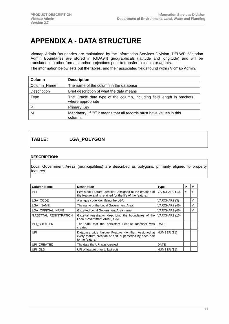
PRODUCT DESCRIPTION Information Services Division Vicmap Admin Department of Environment, Land, Water and Planning Version 2.7
41
APPENDIX A - DATA STRUCTURE
Vicmap Admin Boundaries are maintained by the Information Services Division, DELWP. Victorian Admin Boundaries are stored in (GDA94) geographicals (latitude and longitude) and will be translated into other formats and/or projections prior to transfer to clients or agents.
The information below sets out the tables, and their associated fields found within Vicmap Admin.
Column Description
Column_Name The name of the column in the database
Description Brief description of what the data means
Type The Oracle data type of the column, including field length in brackets where appropriate
P Primary Key
M Mandatory. If “Y” it means that all records must have values in this column.
TABLE: LGA_POLYGON
DESCRIPTION:
Local Government Areas (municipalities) are described as polygons, primarily aligned to property features.
Column Name Description Type P M
PFI Persistent Feature Identifier. Assigned at the creation of the feature and is retained for the life of the feature.
VARCHAR2 (10) Y Y
LGA_CODE A unique code identifying the LGA. VARCHAR2 (3) Y
LGA _NAME The name of the Local Government Area. VARCHAR2 (45) Y
LGA_OFFICIAL_NAME Gazetted Local Government Area name VARCHAR2 (45) Y
GAZETTAL_REGISTRATION Gazettal registration describing the boundaries of the Local Government Area (LGA)
VARCHAR2 (15)
PFI_CREATED The date that the persistent Feature Identifier was created
DATE
UFI Database wide Unique Feature identifier. Assigned at every feature creation or edit, superseded by each edit to the feature.
NUMBER (11)
UFI_CREATED The date the UFI was created DATE
UFI_OLD UFI of feature prior to last edit NUMBER (11)
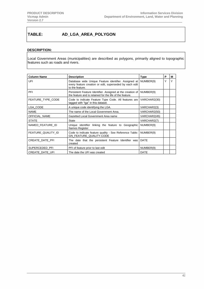
PRODUCT DESCRIPTION Information Services Division Vicmap Admin Department of Environment, Land, Water and Planning Version 2.7
42
TABLE: AD_LGA_AREA_POLYGON
DESCRIPTION:
Local Government Areas (municipalities) are described as polygons, primarily aligned to topographic features such as roads and rivers.
Column Name Description Type P M
UFI Database wide Unique Feature identifier. Assigned at every feature creation or edit, superseded by each edit to the feature.
NUMBER(9) Y Y
PFI Persistent Feature Identifier. Assigned at the creation of the feature and is retained for the life of the feature.
NUMBER(9)
FEATURE_TYPE_CODE Code to indicate Feature Type Code. All features are tagged with “lga” in this dataset.
VARCHAR2(30)
LGA_CODE A unique code identifying the LGA. VARCHAR2(3)
NAME The name of the Local Government Area. VARCHAR2(50)
OFFICIAL_NAME Gazetted Local Government Area name VARCHAR2(45)
STATE State VARCHAR2(7)
NAMED_FEATURE_ID Unique identifier linking the feature to Geographic Names Register
NUMBER(9)
FEATURE_QUALITY_ID Code to indicate feature quality - See Reference Table: GN_FEATURE_QUALITY.CODE
NUMBER(9)
CREATE_DATE_PFI The date that the persistent Feature Identifier was created
DATE
SUPERCEDED_PFI PFI of feature prior to last edit NUMBER(9)
CREATE_DATE_UFI The date the UFI was created DATE
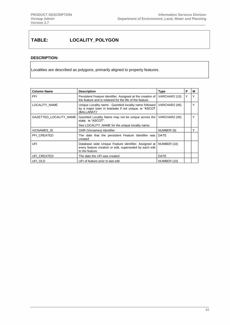
PRODUCT DESCRIPTION Information Services Division Vicmap Admin Department of Environment, Land, Water and Planning Version 2.7
43
TABLE: LOCALITY_POLYGON
DESCRIPTION:
Localities are described as polygons, primarily aligned to property features.
Column Name Description Type P M
PFI Persistent Feature Identifier. Assigned at the creation of the feature and is retained for the life of the feature.
VARCHAR2 (10) Y Y
LOCALITY_NAME Unique Locality name - Gazetted locality name followed by a major town in brackets if not unique, ie “ASCOT (BALLARAT)”
VARCHAR2 (46) Y
GAZETTED_LOCALITY_NAME Gazetted Locality Name may not be unique across the state, ie “ASCOT”.
See LOCALITY_NAME for the unique locality name.
VARCHAR2 (40) Y
VICNAMES_ID GNR (Vicnames) Identifier NUMBER (9) Y
PFI_CREATED The date that the persistent Feature Identifier was created
DATE
UFI Database wide Unique Feature identifier. Assigned at every feature creation or edit, superseded by each edit to the feature.
NUMBER (10)
UFI_CREATED The date the UFI was created DATE
UFI_OLD UFI of feature prior to last edit NUMBER (10)
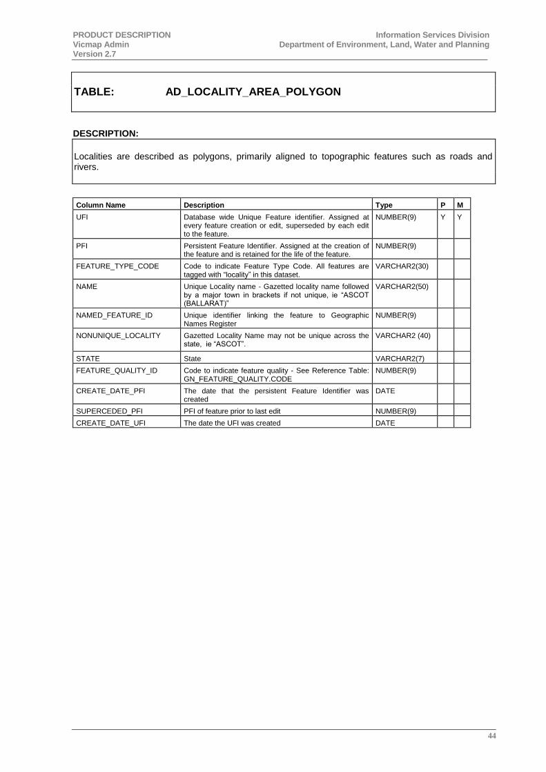
PRODUCT DESCRIPTION Information Services Division Vicmap Admin Department of Environment, Land, Water and Planning Version 2.7
44
TABLE: AD_LOCALITY_AREA_POLYGON
DESCRIPTION:
Localities are described as polygons, primarily aligned to topographic features such as roads and rivers.
Column Name Description Type P M
UFI Database wide Unique Feature identifier. Assigned at every feature creation or edit, superseded by each edit to the feature.
NUMBER(9) Y Y
PFI Persistent Feature Identifier. Assigned at the creation of the feature and is retained for the life of the feature.
NUMBER(9)
FEATURE_TYPE_CODE Code to indicate Feature Type Code. All features are tagged with “locality” in this dataset.
VARCHAR2(30)
NAME Unique Locality name - Gazetted locality name followed by a major town in brackets if not unique, ie “ASCOT (BALLARAT)”
VARCHAR2(50)
NAMED_FEATURE_ID Unique identifier linking the feature to Geographic Names Register
NUMBER(9)
NONUNIQUE_LOCALITY Gazetted Locality Name may not be unique across the state, ie “ASCOT”.
VARCHAR2 (40)
STATE State VARCHAR2(7)
FEATURE_QUALITY_ID Code to indicate feature quality - See Reference Table: GN_FEATURE_QUALITY.CODE
NUMBER(9)
CREATE_DATE_PFI The date that the persistent Feature Identifier was created
DATE
SUPERCEDED_PFI PFI of feature prior to last edit NUMBER(9)
CREATE_DATE_UFI The date the UFI was created DATE
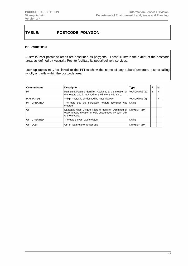
PRODUCT DESCRIPTION Information Services Division Vicmap Admin Department of Environment, Land, Water and Planning Version 2.7
45
TABLE: POSTCODE_POLYGON
DESCRIPTION:
Australia Post postcode areas are described as polygons. These illustrate the extent of the postcode areas as defined by Australia Post to facilitate its postal delivery services.
Look-up tables may be linked to the PFI to show the name of any suburb/town/rural district falling wholly or partly within the postcode area.
Column Name Description Type P M
PFI Persistent Feature Identifier. Assigned at the creation of the feature and is retained for the life of the feature.
VARCHAR2 (10) Y Y
POSTCODE 4 digit Postcode as defined by Australia Post VARCHAR2 (4) Y
PFI_CREATED The date that the persistent Feature Identifier was created
DATE
UFI Database wide Unique Feature identifier. Assigned at every feature creation or edit, superseded by each edit to the feature.
NUMBER (10)
UFI_CREATED The date the UFI was created DATE
UFI_OLD UFI of feature prior to last edit NUMBER (10)
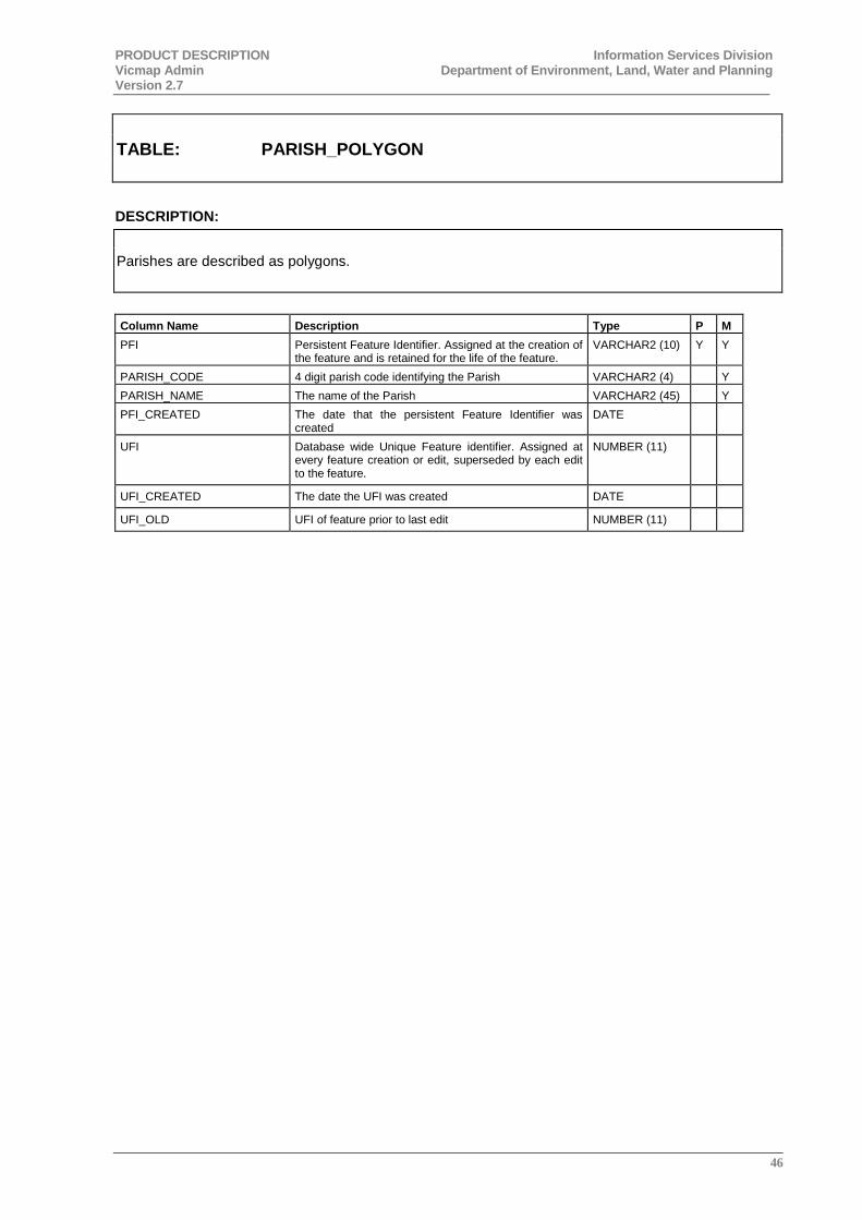
PRODUCT DESCRIPTION Information Services Division Vicmap Admin Department of Environment, Land, Water and Planning Version 2.7
46
TABLE: PARISH_POLYGON
DESCRIPTION:
Parishes are described as polygons.
Column Name Description Type P M
PFI Persistent Feature Identifier. Assigned at the creation of the feature and is retained for the life of the feature.
VARCHAR2 (10) Y Y
PARISH_CODE 4 digit parish code identifying the Parish VARCHAR2 (4) Y
PARISH_NAME The name of the Parish VARCHAR2 (45) Y
PFI_CREATED The date that the persistent Feature Identifier was created
DATE
UFI Database wide Unique Feature identifier. Assigned at every feature creation or edit, superseded by each edit to the feature.
NUMBER (11)
UFI_CREATED The date the UFI was created DATE
UFI_OLD UFI of feature prior to last edit NUMBER (11)
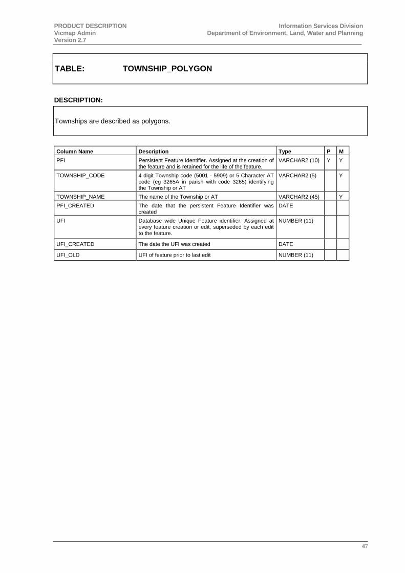
PRODUCT DESCRIPTION Information Services Division Vicmap Admin Department of Environment, Land, Water and Planning Version 2.7
47
TABLE: TOWNSHIP_POLYGON
DESCRIPTION:
Townships are described as polygons.
Column Name Description Type P M
PFI Persistent Feature Identifier. Assigned at the creation of the feature and is retained for the life of the feature.
VARCHAR2 (10) Y Y
TOWNSHIP_CODE 4 digit Township code (5001 - 5909) or 5 Character AT code (eg 3265A in parish with code 3265) identifying the Township or AT
VARCHAR2 (5) Y
TOWNSHIP_NAME The name of the Township or AT VARCHAR2 (45) Y
PFI_CREATED The date that the persistent Feature Identifier was created
DATE
UFI Database wide Unique Feature identifier. Assigned at every feature creation or edit, superseded by each edit to the feature.
NUMBER (11)
UFI_CREATED The date the UFI was created DATE
UFI_OLD UFI of feature prior to last edit NUMBER (11)
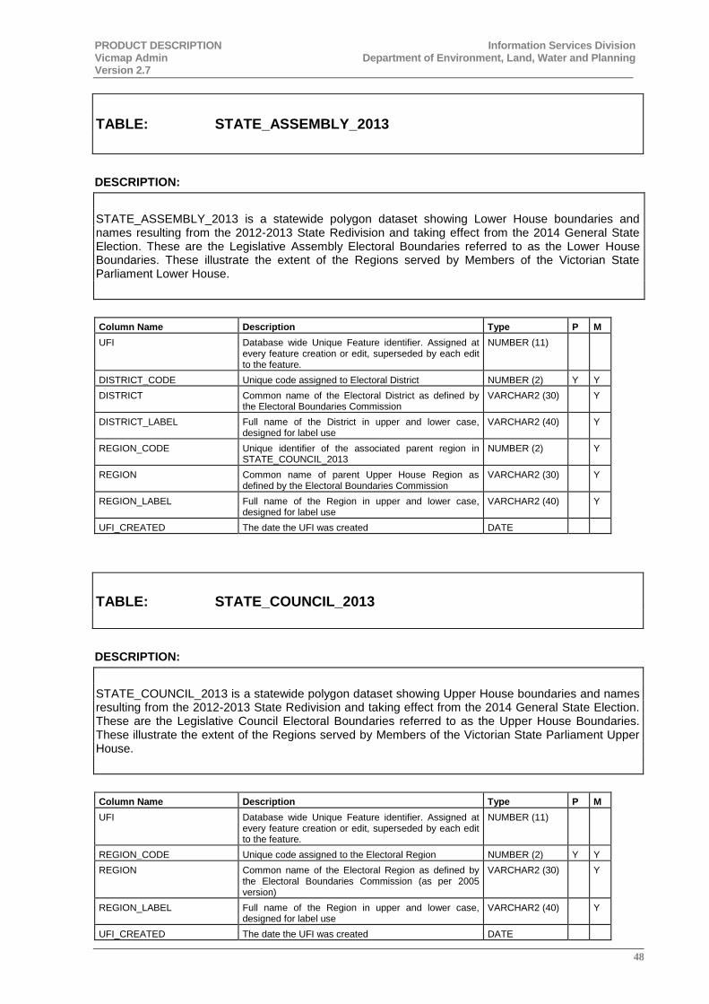
PRODUCT DESCRIPTION Information Services Division Vicmap Admin Department of Environment, Land, Water and Planning Version 2.7
48
TABLE: STATE_ASSEMBLY_2013
DESCRIPTION:
STATE_ASSEMBLY_2013 is a statewide polygon dataset showing Lower House boundaries and names resulting from the 2012-2013 State Redivision and taking effect from the 2014 General State Election. These are the Legislative Assembly Electoral Boundaries referred to as the Lower House Boundaries. These illustrate the extent of the Regions served by Members of the Victorian State Parliament Lower House.
Column Name Description Type P M
UFI Database wide Unique Feature identifier. Assigned at every feature creation or edit, superseded by each edit to the feature.
NUMBER (11)
DISTRICT_CODE Unique code assigned to Electoral District NUMBER (2) Y Y
DISTRICT Common name of the Electoral District as defined by the Electoral Boundaries Commission
VARCHAR2 (30) Y
DISTRICT_LABEL Full name of the District in upper and lower case, designed for label use
VARCHAR2 (40) Y
REGION_CODE Unique identifier of the associated parent region in STATE_COUNCIL_2013
NUMBER (2) Y
REGION Common name of parent Upper House Region as defined by the Electoral Boundaries Commission
VARCHAR2 (30) Y
REGION_LABEL Full name of the Region in upper and lower case, designed for label use
VARCHAR2 (40) Y
UFI_CREATED The date the UFI was created DATE
TABLE: STATE_COUNCIL_2013
DESCRIPTION:
STATE_COUNCIL_2013 is a statewide polygon dataset showing Upper House boundaries and names resulting from the 2012-2013 State Redivision and taking effect from the 2014 General State Election. These are the Legislative Council Electoral Boundaries referred to as the Upper House Boundaries. These illustrate the extent of the Regions served by Members of the Victorian State Parliament Upper House.
Column Name Description Type P M
UFI Database wide Unique Feature identifier. Assigned at every feature creation or edit, superseded by each edit to the feature.
NUMBER (11)
REGION_CODE Unique code assigned to the Electoral Region NUMBER (2) Y Y
REGION Common name of the Electoral Region as defined by the Electoral Boundaries Commission (as per 2005 version)
VARCHAR2 (30) Y
REGION_LABEL Full name of the Region in upper and lower case, designed for label use
VARCHAR2 (40) Y
UFI_CREATED The date the UFI was created DATE
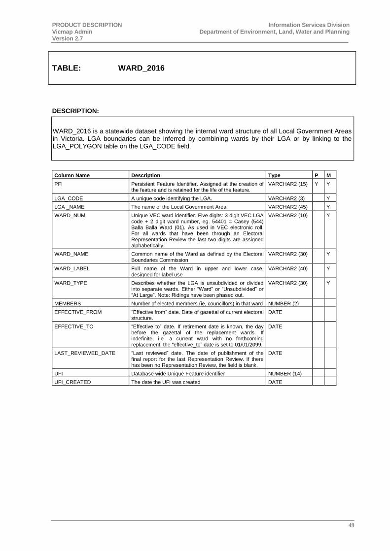
PRODUCT DESCRIPTION Information Services Division Vicmap Admin Department of Environment, Land, Water and Planning Version 2.7
49
TABLE: WARD_2016
DESCRIPTION:
WARD_2016 is a statewide dataset showing the internal ward structure of all Local Government Areas in Victoria. LGA boundaries can be inferred by combining wards by their LGA or by linking to the LGA_POLYGON table on the LGA_CODE field.
Column Name Description Type P M
PFI Persistent Feature Identifier. Assigned at the creation of the feature and is retained for the life of the feature.
VARCHAR2 (15) Y Y
LGA_CODE A unique code identifying the LGA. VARCHAR2 (3) Y
LGA _NAME The name of the Local Government Area. VARCHAR2 (45) Y
WARD_NUM Unique VEC ward identifier. Five digits: 3 digit VEC LGA code + 2 digit ward number, eg. 54401 = Casey (544) Balla Balla Ward (01). As used in VEC electronic roll. For all wards that have been through an Electoral Representation Review the last two digits are assigned alphabetically.
VARCHAR2 (10) Y
WARD_NAME Common name of the Ward as defined by the Electoral Boundaries Commission
VARCHAR2 (30) Y
WARD_LABEL Full name of the Ward in upper and lower case, designed for label use
VARCHAR2 (40) Y
WARD_TYPE Describes whether the LGA is unsubdivided or divided into separate wards. Either “Ward” or “Unsubdivided” or “At Large”. Note: Ridings have been phased out.
VARCHAR2 (30) Y
MEMBERS Number of elected members (ie, councillors) in that ward NUMBER (2)
EFFECTIVE_FROM “Effective from” date. Date of gazettal of current electoral structure.
DATE
EFFECTIVE_TO “Effective to” date. If retirement date is known, the day before the gazettal of the replacement wards. If indefinite, i.e. a current ward with no forthcoming replacement, the “effective_to” date is set to 01/01/2099.
DATE
LAST_REVIEWED_DATE “Last reviewed” date. The date of publishment of the final report for the last Representation Review. If there has been no Representation Review, the field is blank.
DATE
UFI Database wide Unique Feature identifier NUMBER (14)
UFI_CREATED The date the UFI was created DATE
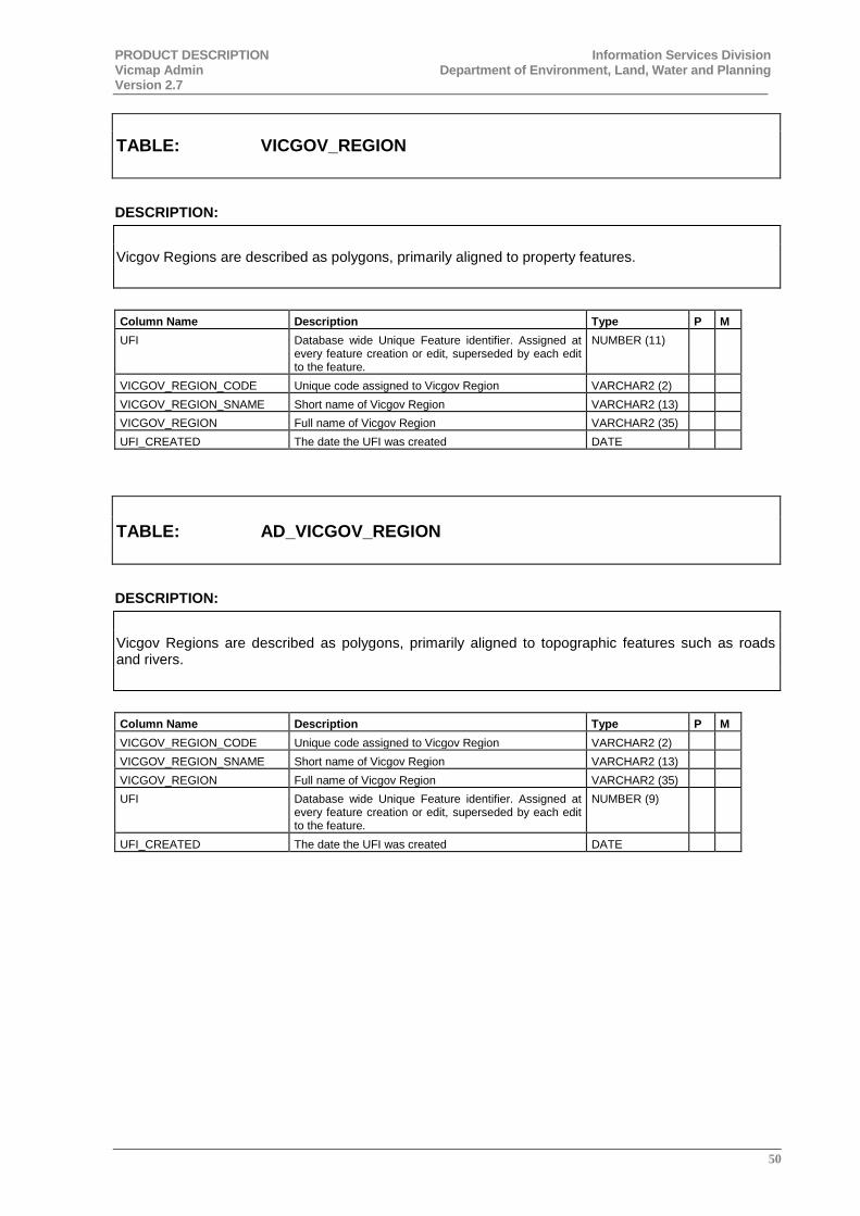
PRODUCT DESCRIPTION Information Services Division Vicmap Admin Department of Environment, Land, Water and Planning Version 2.7
50
TABLE: VICGOV_REGION
DESCRIPTION:
Vicgov Regions are described as polygons, primarily aligned to property features.
Column Name Description Type P M
UFI Database wide Unique Feature identifier. Assigned at every feature creation or edit, superseded by each edit to the feature.
NUMBER (11)
VICGOV_REGION_CODE Unique code assigned to Vicgov Region VARCHAR2 (2)
VICGOV_REGION_SNAME Short name of Vicgov Region VARCHAR2 (13)
VICGOV_REGION Full name of Vicgov Region VARCHAR2 (35)
UFI_CREATED The date the UFI was created DATE
TABLE: AD_VICGOV_REGION
DESCRIPTION:
Vicgov Regions are described as polygons, primarily aligned to topographic features such as roads and rivers.
Column Name Description Type P M
VICGOV_REGION_CODE Unique code assigned to Vicgov Region VARCHAR2 (2)
VICGOV_REGION_SNAME Short name of Vicgov Region VARCHAR2 (13)
VICGOV_REGION Full name of Vicgov Region VARCHAR2 (35)
UFI Database wide Unique Feature identifier. Assigned at every feature creation or edit, superseded by each edit to the feature.
NUMBER (9)
UFI_CREATED The date the UFI was created DATE
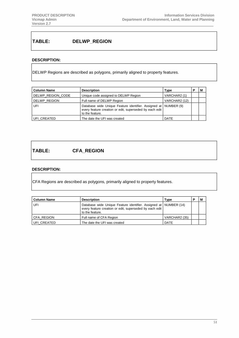
PRODUCT DESCRIPTION Information Services Division Vicmap Admin Department of Environment, Land, Water and Planning Version 2.7
51
TABLE: DELWP_REGION
DESCRIPTION:
DELWP Regions are described as polygons, primarily aligned to property features.
Column Name Description Type P M
DELWP_REGION_CODE Unique code assigned to DELWP Region VARCHAR2 (1)
DELWP_REGION Full name of DELWP Region VARCHAR2 (12)
UFI Database wide Unique Feature identifier. Assigned at every feature creation or edit, superseded by each edit to the feature.
NUMBER (9)
UFI_CREATED The date the UFI was created DATE
TABLE: CFA_REGION
DESCRIPTION:
CFA Regions are described as polygons, primarily aligned to property features.
Column Name Description Type P M
UFI Database wide Unique Feature identifier. Assigned at every feature creation or edit, superseded by each edit to the feature.
NUMBER (14)
CFA_REGION Full name of CFA Region VARCHAR2 (35)
UFI_CREATED The date the UFI was created DATE

PRODUCT DESCRIPTION Information Services Division Vicmap Admin Department of Environment, Land, Water and Planning Version 2.7
52
TABLE: CFA_DISTRICT
DESCRIPTION:
CFA Districts are described as polygons, primarily aligned to property features.
Column Name Description Type P M
UFI Database wide Unique Feature identifier. Assigned at every feature creation or edit, superseded by each edit to the feature.
NUMBER (14)
CFA_DISTRICT Unique code assigned to CFA District VARCHAR2 (10)
UFI_CREATED The date the UFI was created DATE
TABLE: CFA_TFB_DISTRICT
DESCRIPTION:
CFA TFB Districts are described as polygons, primarily aligned to property features. These illustrate the extent of the Total Fire Ban districts as defined by the CFA.
Column Name Description Type P M
UFI Database wide Unique Feature identifier. Assigned at every feature creation or edit, superseded by each edit to the feature.
NUMBER (14)
TFB_DISTRICT Full name of Total Fire Ban District. VARCHAR2 (40)
UFI_CREATED The date the UFI was created DATE
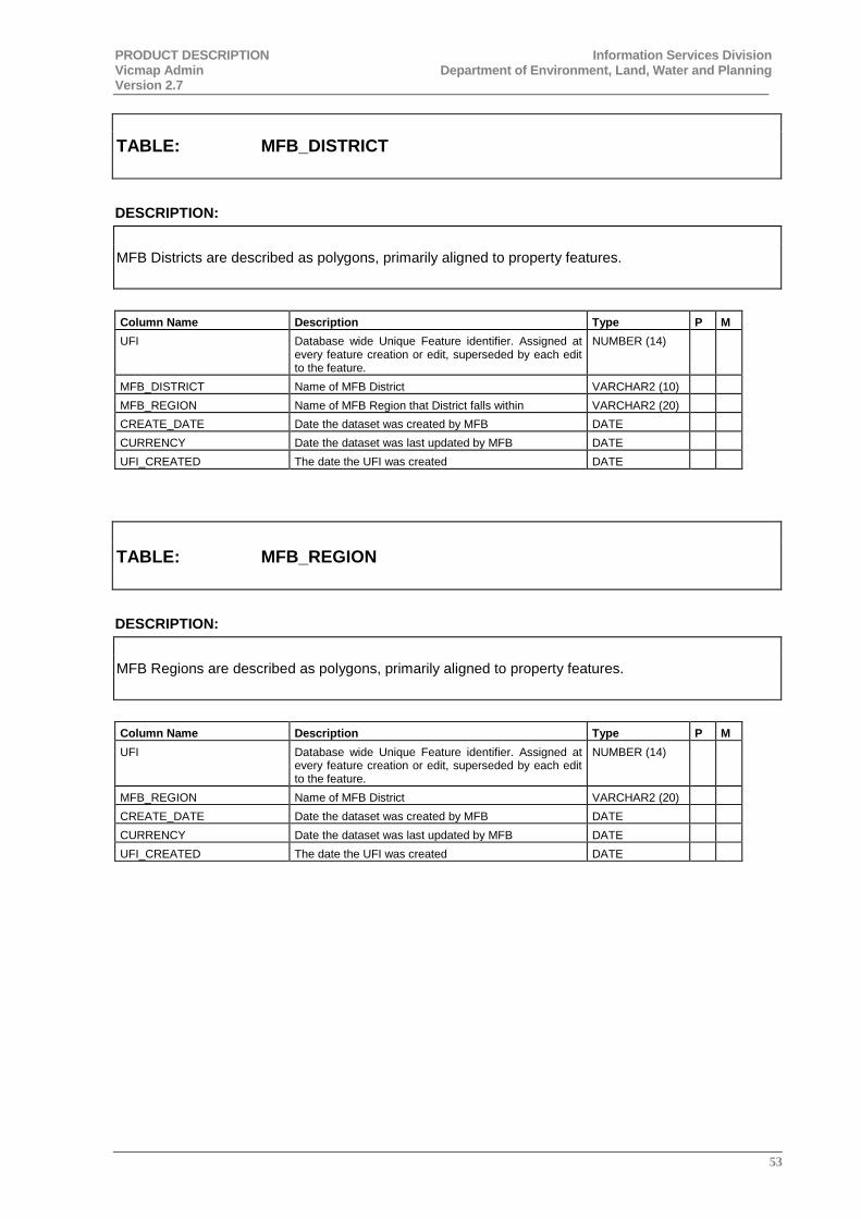
PRODUCT DESCRIPTION Information Services Division Vicmap Admin Department of Environment, Land, Water and Planning Version 2.7
53
TABLE: MFB_DISTRICT
DESCRIPTION:
MFB Districts are described as polygons, primarily aligned to property features.
Column Name Description Type P M
UFI Database wide Unique Feature identifier. Assigned at every feature creation or edit, superseded by each edit to the feature.
NUMBER (14)
MFB_DISTRICT Name of MFB District VARCHAR2 (10)
MFB_REGION Name of MFB Region that District falls within VARCHAR2 (20)
CREATE_DATE Date the dataset was created by MFB DATE
CURRENCY Date the dataset was last updated by MFB DATE
UFI_CREATED The date the UFI was created DATE
TABLE: MFB_REGION
DESCRIPTION:
MFB Regions are described as polygons, primarily aligned to property features.
Column Name Description Type P M
UFI Database wide Unique Feature identifier. Assigned at every feature creation or edit, superseded by each edit to the feature.
NUMBER (14)
MFB_REGION Name of MFB District VARCHAR2 (20)
CREATE_DATE Date the dataset was created by MFB DATE
CURRENCY Date the dataset was last updated by MFB DATE
UFI_CREATED The date the UFI was created DATE
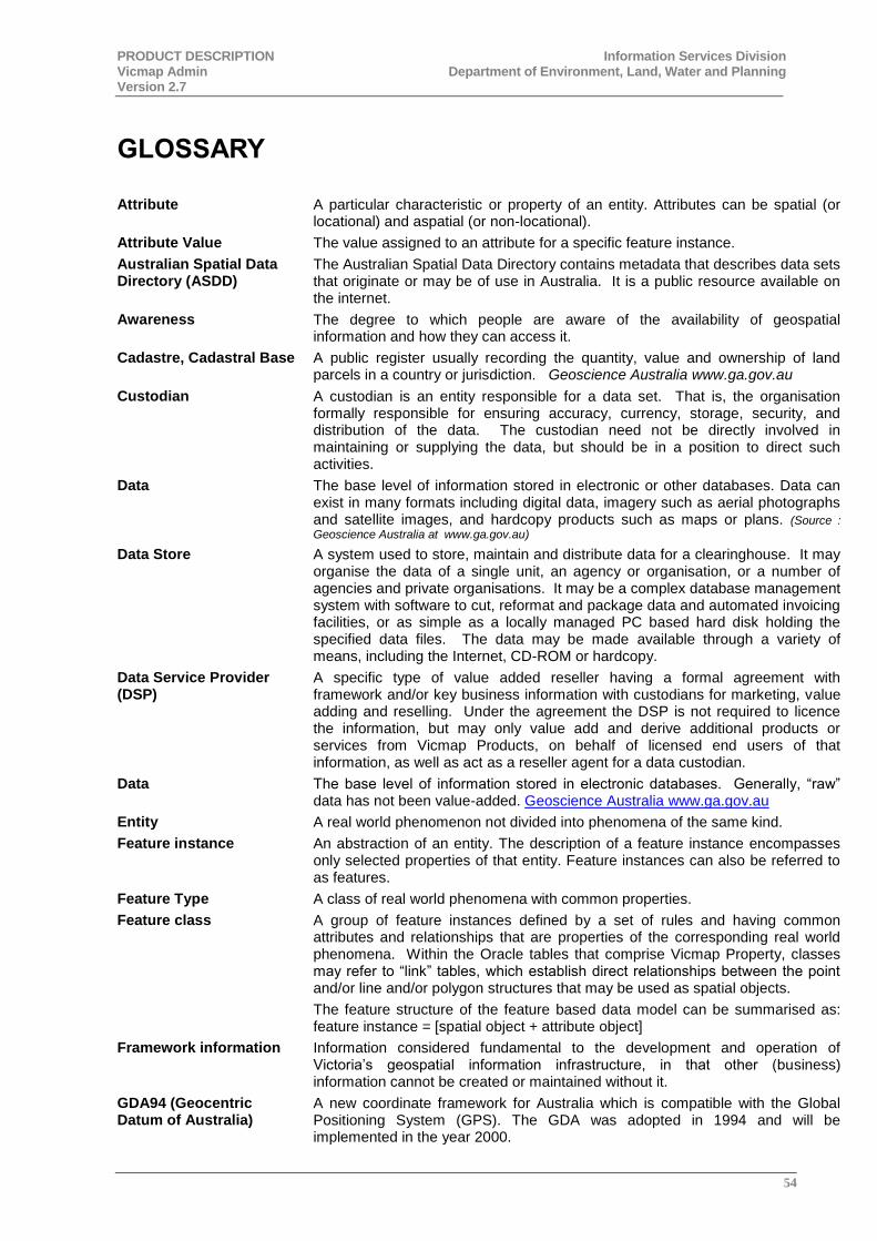
PRODUCT DESCRIPTION Information Services Division Vicmap Admin Department of Environment, Land, Water and Planning Version 2.7
54
GLOSSARY
Attribute A particular characteristic or property of an entity. Attributes can be spatial (or locational) and aspatial (or non-locational).
Attribute Value The value assigned to an attribute for a specific feature instance.
Australian Spatial Data Directory (ASDD)
The Australian Spatial Data Directory contains metadata that describes data sets that originate or may be of use in Australia. It is a public resource available on the internet.
Awareness The degree to which people are aware of the availability of geospatial information and how they can access it.
Cadastre, Cadastral Base A public register usually recording the quantity, value and ownership of land parcels in a country or jurisdiction. Geoscience Australia www.ga.gov.au
Custodian A custodian is an entity responsible for a data set. That is, the organisation formally responsible for ensuring accuracy, currency, storage, security, and distribution of the data. The custodian need not be directly involved in maintaining or supplying the data, but should be in a position to direct such activities.
Data The base level of information stored in electronic or other databases. Data can exist in many formats including digital data, imagery such as aerial photographs and satellite images, and hardcopy products such as maps or plans. (Source :
Geoscience Australia at www.ga.gov.au)
Data Store A system used to store, maintain and distribute data for a clearinghouse. It may organise the data of a single unit, an agency or organisation, or a number of agencies and private organisations. It may be a complex database management system with software to cut, reformat and package data and automated invoicing facilities, or as simple as a locally managed PC based hard disk holding the specified data files. The data may be made available through a variety of means, including the Internet, CD-ROM or hardcopy.
Data Service Provider (DSP)
A specific type of value added reseller having a formal agreement with framework and/or key business information with custodians for marketing, value adding and reselling. Under the agreement the DSP is not required to licence the information, but may only value add and derive additional products or services from Vicmap Products, on behalf of licensed end users of that information, as well as act as a reseller agent for a data custodian.
Data The base level of information stored in electronic databases. Generally, “raw” data has not been value-added. Geoscience Australia www.ga.gov.au
Entity A real world phenomenon not divided into phenomena of the same kind.
Feature instance An abstraction of an entity. The description of a feature instance encompasses only selected properties of that entity. Feature instances can also be referred to as features.
Feature Type A class of real world phenomena with common properties.
Feature class A group of feature instances defined by a set of rules and having common attributes and relationships that are properties of the corresponding real world phenomena. Within the Oracle tables that comprise Vicmap Property, classes may refer to “link” tables, which establish direct relationships between the point and/or line and/or polygon structures that may be used as spatial objects.
The feature structure of the feature based data model can be summarised as: feature instance = [spatial object + attribute object]
Framework information Information considered fundamental to the development and operation of Victoria’s geospatial information infrastructure, in that other (business) information cannot be created or maintained without it.
GDA94 (Geocentric Datum of Australia)
A new coordinate framework for Australia which is compatible with the Global Positioning System (GPS). The GDA was adopted in 1994 and will be implemented in the year 2000.

PRODUCT DESCRIPTION Information Services Division Vicmap Admin Department of Environment, Land, Water and Planning Version 2.7
55
OR
A new ‘best fit’ mathematical model of the whole Earth’s surface adopted by Australia as the basis for mapping and coordinate systems. GDA has been adopted for its increased accuracy over previous datums and for its compatibility with Global Positioning Systems (GPS). GDA94 is the geodetic coordinate (latitude and longitude) computed in terms of AGD at 1 January 1994.
Hydrology Surface water features, including non-perennial water flows and drainage lines.
Information The result of manipulating, analysing and interpreting data to produce a result which adds value or utility to the original data.
Information Services Division
A body within DELWP responsible for geospatial policy for the State and for providing and maintaining a statewide geospatial infrastructure, including the Victorian Geodetic Framework and Vicmap.
Licensee or
Licensed user
A person or entity which has been provided, or is seeking access to Vicmap Products through an annual access licence agreement.
Metadata Data about data. Metadata is a structured summary of information that describes the data. Metadata includes, but is not restricted to, characteristics such as the content, quality, currency, access and availability of the data.
Oracle Relational Data Base Management System used Spatial Information Infrastructure and LogicaCMG to store and manage Vicmap data.
Page 0, Page 1, Page 2 The “Pages” concept devised by ANZLIC for a national metadata framework. Within this framework, comparatively general information is recorded at Page 0, the highest level, and additional information is recorded at lower levels such as Page 1 and Page 2. Page 0 data should always be freely available to all users, and would contain sufficient elements to allow a user to locate all relevant and available datasets. Subsequent pages provide the opportunity for data custodian agencies to include additional information not contained at the Page 0 level.
Parcel A separate or distinct portion of land which is a registered legal entity.
Postcode polygon Australia Post postal delivery and administration district DELWPcted spatially by a polygon formed by the postcode boundaries defined by Australia Post. Each postcode polygon is identified by a unique 4 digit number attribute. Within Victoria, postcode areas are generally being defined and aligned to incorporate whole localities (suburbs, towns and rural districts) as gazetted by the Registrar of Geographic Names. Some splitting of localities may occur in densely populated (eg. Melbourne) or large geographical areas (eg. some rural localities).
Note : Single, high volume, point, postcode locations are not included in the Victorian Postcode Boundaries data set.
Pricing The pricing structure applied to sets of geospatial information. This also includes licensing.
Property Land, usually contiguous, under one ownership, and of a common class and tenure. (Where “contiguous” sometimes ignores intervening roads and reserves).
Road A corridor of land set aside for access purposes.
Spatial Datamart Website enabling customers to search, order and obtain spatial data. It provides access to authoritative spatial data for the State of Victoria held by the Department of Environment, Land, Water and Planning.
Title
A certified document sealed by the Registrar-General certifying that and estate of freehold land is vested in the registered proprietor subject to registered encumbrances, liens, estates, or interests endorsed thereon.
User A person or entity who accesses geospatial information.
Vicmap
Vicmap is a set of geospatially related data products including Address, Property, Transport, Admin (boundaries), Elevation, Hydro (hydrology), Imagery and Position (geodetic services). They are the underlying foundation to Victoria's primary mapping and geographic information systems. They are produced and managed by the Department of Environment, Land, Water and Planning.

PRODUCT DESCRIPTION Information Services Division Vicmap Admin Department of Environment, Land, Water and Planning Version 2.7
56
Victorian Electoral Commission
The Victorian Electoral Commission is an independent body established by law to conduct elections within the State of Victoria.
Its mission is to deliver quality electoral services according to law efficiently, effectively and with complete impartiality. Its principal function is the proper conduct of State elections and by-elections. VEC also provides local government election services. Refer : http://www.vec.vic.gov.au
Victorian Spatial Data Directory (VSDD)
The Victorian Spatial Data Directory contains metadata that describes data sets that originate or may be of use in Victoria. It is a public resource available on the Internet.