Vicmap Address Product Description - DELWP · Web viewDepartment of Environment, Land, Water &...
25
www.delwp.vic.gov.au Product data description Vicmap™ Vegetation AS/NZS ISO 19131:2008 compliant Version 4.0 January 2018 Applies to data model 4.1 May 2015
Transcript of Vicmap Address Product Description - DELWP · Web viewDepartment of Environment, Land, Water &...

www.delwp.vic.gov.au
Product data descriptionVicmap™ Vegetation
AS/NZS ISO 19131:2008 compliant
Version 4.0 January 2018 Applies to data model 4.1 May 2015

© The State of Victoria Department of Environment, Land, Water and Planning 2018
This work is licensed under a Creative Commons Attribution 4.0 International licence. You are free to re-use the work under that licence, on the condition that you credit the State of Victoria as author. The licence does not apply to any images, photographs or branding, including the Victorian Coat of Arms, the Victorian Government logo and the Department of Environment, Land, Water and Planning (DELWP) logo. To view a copy of this licence, visit http://creativecommons.org/licenses/by/4.0/
DisclaimerThis publication may be of assistance to you but the State of Victoria and its employees do not guarantee that the publication is without flaw of any kind or is wholly appropriate for your particular purposes and therefore disclaims all liability for any error, loss or other consequence which may arise from you relying on any information in this publication.
AccessibilityIf you would like to receive this publication in an alternative format, please telephone the DELWP Customer Service Centre on 136186, email [email protected] or via the National Relay Service on 133 677 www.relayservice.com.au. This document is also available on the internet at www.delwp.vic.gov.au.

Document history
Version Date Author Note
1.0 August2014 J White Initial publication
1.4 March 2015 R Stewart Update MoG changes
1.5 May 2015 R Stewart Re-instated plantation information & other minor edits
1.6 October 2015 D Blain Added “Unknown” as a feature type to Plantation Type Table
2.0 October 2015 R Stewart Update MoG changes & other minor edits
2.1 October 2015 R Stewart Minor edits
2.2 October 2015 R Stewart Minor edits
3.0 May 2016 J LeLievreD BlainJ White
New template & update MoG changes
4.0 January 2018 J LeLievre New template & update MoG changes
This document has been formatted and structured in compliance with AS/NZS ISO 19131:2008 Geographic Information – Data product specifications.
Publication ApprovalBefore this is approved - compliant metadata must be completed in MetaShare.
Title: Vicmap Data Services Manager Title: Foundation Data Portfolio Manager
Signature: Signature:
Date: Date:
Title: Vicmap Foundation Data Team Leader
Signature:
Date:
An approved printed copy must be maintained in an appropriate DELWP TRIM file.

Table of ContentsDocument history.......................................................................................................................................... 1
Publication Approval..................................................................................................................................... 1
Table of Contents.......................................................................................................................................... 2
Overview......................................................................................................................................................... 3
Vicmap™........................................................................................................................................................ 3
Data product specification title.................................................................................................................... 3
Responsible party.......................................................................................................................................... 3
Terms and definitions.................................................................................................................................... 4
Acronyms....................................................................................................................................................... 5
Informal description of the data product.....................................................................................................6
Specification scope....................................................................................................................................... 6
Data product identification........................................................................................................................... 6
Data content and structure........................................................................................................................... 7Data content................................................................................................................................................... 7Data models................................................................................................................................................... 7Data dictionary............................................................................................................................................... 7Data structure................................................................................................................................................ 7
Reference systems........................................................................................................................................ 8
Data quality.................................................................................................................................................... 8
Accuracy......................................................................................................................................................... 8
Logical Consistency...................................................................................................................................... 9
Data capture................................................................................................................................................... 9
Data maintenance........................................................................................................................................ 10
Data product delivery.................................................................................................................................. 11
Metadata....................................................................................................................................................... 12
Appendix A: Data & object models............................................................................................................13
Appendix B: Data dictionary....................................................................................................................... 14
Appendix C: Reference tables.................................................................................................................... 16

OverviewVicmap™ Vicmap™ is the foundation that underlies most spatial information in Victoria. This portfolio of spatial related authoritative data products, made up from individual datasets, is developed and managed by the Department of Environment, Land, Water & Planning. The information provides the foundation to Victoria’s primary mapping and spatial information systems, and is used for building business information and systems.
Vicmap is a registered trademark of the Victorian Government and is synonymous with authoritative statewide mapping since 1975. The Vicmap portfolio includes:
Vicmap AddressVicmap AdminVicmap Crown Land TenureVicmap ElevationVicmap Features of InterestVicmap HydroVicmap ImageryVicmap Index
Vicmap LiteVicmap PlanningVicmap PositionVicmap PropertyVicmap Topographic MappingVicmap TransportVicmap Vegetation
Vicmap data is supported by a collection of Reference Tables, Vicmap Reference Tables. A reference table may list the full name, description and other attributes associated with a feature code or identifier.
Further information can be found at www2.delwp.vic.gov.au/maps
Data product specification titleVicmap™ Vegetation
Responsible party Department of Environment, Land, Water and Planning
PO Box 527, Melbourne VIC 3001 Australia
Product description – Vicmap Vegetation Version 4.0Department of Environment, Land, Water & Planning

Terms and definitionsFor the purpose of this document, the following terms and definitions apply.
Term DefinitionANZLIC ID A unique identifier enabling metadata records to be discovered and differentiated
within a structured data library.Attribute A characteristic of a feature that may occur as a type or an instance.Custodian An organisation responsible for ensuring the accuracy, currency, distribution of their
data and the terms and conditions of access and use.Data type Specification of a value domain with operations allowed on values in this domain
Refer to AS/NZS ISO 19103Dataset Identifiable collection of data. Maybe as small as a single feature or feature attribute
contained within a larger dataset. A hardcopy map maybe considered a dataset.Refer to AS/NZS ISO 19115
Dataset series Collection of datasets sharing the same product specification, also known as a product.
Domain A well-defined set both necessary and sufficient, as everything that satisfies the definition in the set and everything that does not satisfy the definition is necessarily outside the set.Refer to ISO/TS 19103
the Department
Meaning the Department of Environment, Land, Water & Planning (DELWP).
Entity A unit of data that can be classified and have stated relationship with other entities.Feature An abstraction of real-world phenomena. A feature may occur as a type or an
instance. Feature type or instance shall be used when only one is meant.The feature structure of the feature based data model can be summarised as:feature instance = [spatial object + attribute object]
Metadata Metadata is ‘data about data’ and provides a synopsis about the data lineage, accuracy and details about access permissions.Refer to ISO 19115 Geographic information ― Metadata
Parent metadata record
Parent metadata records act as a cover note for a product that contains a dataset series for search, discovery & delivery purposes.
Persistent Feature Identifier (PFI)
The unique code provide at creation of the feature which remains until the feature is retired.
Product Dataset or dataset series that conforms to a data product specification.Quality Totality of characteristics of a product that bear on its ability to satisfy stated and
implied needs. Refer to:ISO 19113 Geographic information ― Quality principlesISO 19114 Geographic information ― Quality evaluation procedures
the State Victoria.Unique Feature identifier (UFI)
Each feature is uniquely identified and renewed with each change.

AcronymsFor the purpose of this document, the following acronyms may apply.
Acronym DefinitionCFA Country Fire Authority
DALA DELWP Data Access License Agreement
DELWP Department of Environment, Land, Water & Planning
FIB Forest Industry Brigade
NES Notification for Editing Service
RMSE Root-Mean-Square Error
SDM Spatial DataMart
SPOT Satellite Pour l’Observation de la Terre (French)
VGDD Victorian Government Data Directory
Product description – Vicmap Vegetation Version 4.0Department of Environment, Land, Water & Planning

Informal description of the data productVicmap Vegetation contains topologically structured digital datasets (tree density and plantations) depicting areas of tree or woody cover across the State of Victoria. Vicmap Vegetation assists users in emergency, environmental management and map production. Key users are utilities, environmental managers, local government, cartographers and emergency services organisations.Product updates are made available weekly through the Vicmap maintenance lifecycle. The data is sourced from authoritative Custodians yearly via the DELWP Custodianship Program.
Specification scopeLevelDataset.
Extent & coverageTree densityTree density data within Vicmap Vegetation covers Victoria and extends to a limited extent into New South Wales and South Australia.
PlantationThe Plantations data within Vicmap Vegetation covers the State of Victoria.
Data product identificationTitleVicmap™ Vegetation
Alternative titleVicmap Vegetation: Tree densityVicmap Vegetation: PlantationVMVEG
Abstract
Vicmap Vegetation consists of two feature-type datasets:
Tree Density: Consists of information showing the presence of forest/tree cover. The forest cover is divided into three distinct classes: dense, medium and scattered, showing the spatial separation of woody vegetation.
Plantations: Consists of information showing the extent of softwood and hardwood plantings. Most of this information is supplied through a cooperative data sharing agreement between DELWP, CFA and the plantation managers or owners who are registered as a Forest Industry Brigade. Small plantation estates which fall under the Forest Industry Brigade threshold will be progressively added over time.
Purpose
Tree Density: To supply information where woody vegetation exists across the state and to give an indication of the separation between patches.
Plantation: Its primary purpose is to map hardwood and softwood plantations within the landscape for bushfire and emergency mapping applications.

Topic CategoryBiota.
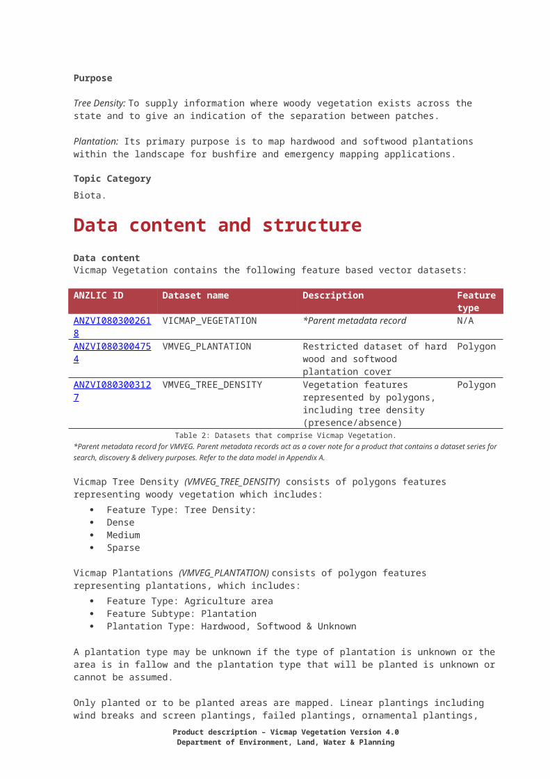
Data content and structureData contentVicmap Vegetation contains the following feature based vector datasets:
ANZLIC ID Dataset name Description Feature type
ANZVI0803002618 VICMAP_VEGETATION *Parent metadata record N/AANZVI0803004754 VMVEG_PLANTATION Restricted dataset of hard wood
and softwood plantation coverPolygon
ANZVI0803003127 VMVEG_TREE_DENSITY Vegetation features represented by polygons, including tree density (presence/absence)
Polygon
Table 2: Datasets that comprise Vicmap Vegetation.*Parent metadata record for VMVEG. Parent metadata records act as a cover note for a product that contains a dataset series for search, discovery & delivery purposes. Refer to the data model in Appendix A.
Vicmap Tree Density (VMVEG_TREE_DENSITY) consists of polygons features representing woody vegetation which includes:
Feature Type: Tree Density: Dense Medium Sparse
Vicmap Plantations (VMVEG_PLANTATION) consists of polygon features representing plantations, which includes:
Feature Type: Agriculture area Feature Subtype: Plantation Plantation Type: Hardwood, Softwood & Unknown
A plantation type may be unknown if the type of plantation is unknown or the area is in fallow and the plantation type that will be planted is unknown or cannot be assumed.
Only planted or to be planted areas are mapped. Linear plantings including wind breaks and screen plantings, failed plantings, ornamental plantings, remnant vegetation and non-productive areas such as clearings, roads, water bodies, grasslands, pasture land and rocky outcrops are normally not included in this dataset.
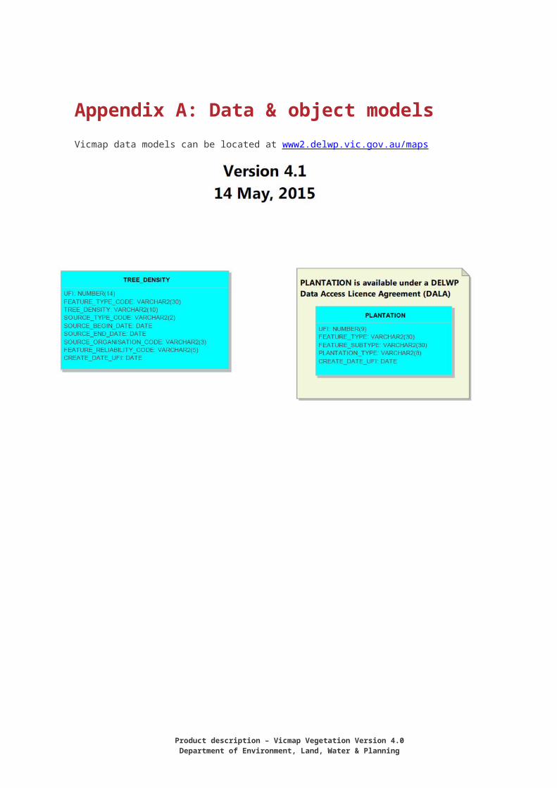
Data modelsSee Appendix A.
The Vicmap Vegetation product data model is published on the Department’s website www2.delwp.vic.gov.au/maps
Data dictionarySee Appendix B.
Data structureThe structure includes:
Topologically structured (vertical topology) with other Vicmap products Seamless statewide data Conforms to national data models (i.e. ICSM)
Product description – Vicmap Vegetation Version 4.0Department of Environment, Land, Water & Planning

Additional information about features contained in attribute tables (i.e. data quality, feature type).
Rules and/or characteristics that apply to all Vicmap data:
A Persistent Feature Identifier (PFI) is generated once for each feature at the point of creation and remains constant until a feature is retired. A PFI is unique to, and cannot be reused within a particular table. However, you may have the same PFI number in different tables but does not relate to the same feature entity.
The Unique Feature Identifier (UFI) is generated for each feature at the point of creation and changes with each modification or version. This allows users to track the changes made to a feature over time.
Reference systemsVicmap Address is mapped to the Geocentric Datum of Australia (GDA) and the Australian Height Datum (AHD). Data is held in geographic latitude and longitude computed in terms of the GDA at 01 January 1994 (GDA94).The temporal reference system for Vicmap is the Gregorian calendar.
Data qualityAccuracyVicmap Vegetation has been built on the existing Vicmap products and maintains a strong relative positional accuracy. Therefore, any deficiency within Vicmap data has been inherited by the overlying data to ensure vertical alignment with other Vicmap datasets is retained.
Area Vicmap Property Source Mapping Scales
Nominal Positional Accuracy*
Developing Urban Survey accurate CAD files ±0.1m
Melbourne Metropolitan Area 1:480 and 1:500 ±0.5m
Rural Urban 1:2,500 ±2.5m
Urban Fringe 1:10,000 ±10m
Rural 1:25,000 & 1:50,000 ±25m
* Positional Accuracy error as measured against the geodetic network of Australia.Table 2: Mapping scales & respective positional accuracy for Vicmap Property.
The following procedures are undertaken as normal update/maintenance routines, to ensure conformity of the data to specification:
Customised menus for data editing which provide on the fly logical consistency attribute checking as data is edited
Automated data QA processes to validate topological integrity, completeness and logical consistency
Automated data loading routines, reflecting business rules for data population, to ensure data accuracy
Independent review of data upon loading including aspatial attributes, spatial extents and successful data load
Validation of accepted types according to approved reference tables Validation of entity PFI/UFI tags for uniqueness.
The horizontal spatial accuracy is dependent upon the theme:
Tree Density: Primary input was derived from SPOT Panchromatic satellite imagery which has a pixel resolution of 10m. The spatially accuracy of this input was 1.5 RMSE.
Plantation: Primary source of input is from the custodian of the original data source, with the positional accuracy unknown. The mapping of plantations is as provided by the data provider and is usually not spatially edited. Checks against high resolution aerial photography indicate the spatial accuracy is high and is within 20m.
Feature and attribute accuracy (Thematic accuracy)
Tree Density The three density classes are derived by automated grid cell processing, thereby ensuring consistency. The attribute accuracy of the density classes is solely dependent on the accuracy of the SPOT Panchromatic/Monochratic image classifications. The tree cover classifications of the SPOT imagery have, in general, overestimated the occurrence of trees. Although spatially very accurate, the classifications need to be "cleaned" by a process of visual interpretation and manual editing. The "Feature_Reliability_Code" polygon attribute has been added as an indicator of the classification accuracy. This indicates to the user how much field verification has been undertaken on the original tree cover classification. The feature_reliability_code contains three values of verified, unverified and unknown.
Verified means it has been independently checked and the feature exists Unverified no checking has taken place and Unknown, no record has been supplied regarding its verification.
PlantationWhile auditing of Plantation attributes against the custodial source establishes a high level of confidence in the data, there is no audit of the data against the corresponding real-world features, as this is seen as the responsibility of the relevant custodians.
Vicmap Vegetation relies on the Custodial source for accuracy against ground truth (real world). The Department may conduct ad hoc audit for due diligence.
Logical ConsistencyLogical consistency is a measure of the degree to which data complies with the technical specification.
Tree DensityThe test procedures are a mixture of software scripts and on-screen, visual checks. All polygons are automatically generated in a raster to vector conversion. All polygons are closed and labelled consistently. All relationships between attributes are logical.
Plantation The test procedures are a mixture of software scripts and on-screen, visual checks. All polygons are closed and labelled consistently. All relationships between attributes are logical.
Data captureVicmap relies on the agreements and MoU’s signed with authoritative Custodians, through the DELWP Custodianship Program, for its data.
The Department may also use imagery to improve the completeness of a dataset in absence of an authoritative Custodian.
Examples of Custodians and/or those that may supplement or verified data are listed below: Federal, State and Local Government
Product description – Vicmap Vegetation Version 4.0Department of Environment, Land, Water & Planning

Government agencies and authorities (e.g. Parks Victoria, Melbourne Water, VicRoads) Registrar of Geographic Names – Department of Environment, Land, Water, and Planning Crown Land Management – Department of Environment, Land, Water, and Planning Fire Management - Department of Environment, Land, Water, and Planning Emergency & Essential Services, and Utility companies.
Tree Density All content is derived from DELWP satellite imagery including cross border data.
PlantationsThe majority of the content is sourced from large plantation owners or managers who currently have a FIB under a cooperative arrangement data sharing agreement with DELWP and the CFA. Plantations which have not been sourced from the plantation owners or /managers are obtained via the standard Vicmap edit/update procedures.
History
Tree Density The creation of the forest density layer was a two-step process. First the mapping of woody vegetation, using satellite imagery. The second the creation of the three density types. A summary of the processing steps is provided below:
Woody or tree cover extent detail was compiled using SPOT Panchromatic satellite imagery. An automatic classification method was used to derive the extent of vegetation followed by manual editing to remove any large errors. The manual editing was required due to the limits of the spectral discrimination the SPOT Panchromatic was able to achieve to woody vegetation from the surrounding features.
The presence/absence of the tree cover (Woody vegetation greater than two metres in height and with a crown cover (foliar density) greater than 10 percent) was grouped into the three density classes of dense, medium and sparse. This was achieved by an automatic proximity cell based procedure. The grouping of the tree cover was used to simplify the representation of trees when converting the raster presence/absence data to a polygon/vector bases data. It is also an effective means of showing scattered woody vegetation.
Control for the satellite imagery was created by using Vicmap Transport as ground control points. A 2D polynomial model was then used to register the imagery.
The currency of the data is based upon the date of the satellite imagery used. The collection period is from March 1993 up to October 2001. Due to the capture method, a single polygon of tree cover could have multiple dates. It is for this reason that each polygon is attributed with the begin and end date of the satellite image used. E.g. If a single image is used to derive a tree density polygon, both the upper and lower dates would be the same. If more than one image was used the earliest and latest date would be indicated.
Plantations Due to the varying sources of information the input data has been generalised to the common standard in regard to the attribution to create the plantation type. However, the spatial boundaries have not been changed from the original source. This may result in overlap of separate plantation extents.
Data maintenance Vicmap can change under one of the following two terms:
Vicmap maintenance - The incorporation of new data to an existing dataset via an M1, spatial change requests or scheduled Custodial supply. No changes are made to the data or object model, therefore does not require change management processes. Additions can be seen in

the weekly Vicmap update. Vicmap improvements – changes to a dataset that may see existing data over a large area
replaced and/or may require the data model changed. Vicmap Improvement must be managed through the Vicmap Change Management Forum and are typically carried out as part of a project requiring additional funding. and may reinvolve a new Custodial data requiring change management.
DELWP obtains updates to data from authoritative Custodians at various intervals based on the agreed Custodianship arrangements (i.e. quarterly, yearly and ad hoc). Updates are incorporated into Vicmap daily and made available weekly: noting that Vicmap data is never deleted, only retired and archived for legal purposes. Data is date stamped to reflect the last time the record was verified.
Reported errors or omissions are verified with the authoritative source before a change is made. Most notifications regarding anomalies are received via the Notification for Editing Service (NES) and once verified will be incorporated into Vicmap. Feedback from users and stakeholders, including emergency services dispatch providers, ensures that the highest standards are maintained. Approximately 5% of all maintenance advice notices processed are separately audited by DELWP to confirm accuracy, completeness and correctness in the capture process.
Data made available to Vicmap under Cross Border agreements is subject to the maintenance regime of the relevant jurisdiction and is not subject to the same maintenance regime of the Vicmap datasets. Cross border data made available in Vicmap is not updated regularly.
Vicmap Vegetation maintenanceVicmap Vegetation: Tree Density is a static dataset. Currently there is no ongoing program to maintain the Tree Density across the state. The majority of maintenance will be based upon the notification and consequent editing of errors.
Major updates to the Plantation data will occur annually based upon information received from the main custodian of the input data. Minor updates may occur throughout the year on an irregular basis. These updates are based upon notification of errors or to add small areas which have not been included from the major input sources.
Data product deliveryAccess & licensingData available under the DataVic policy www.data.vic.gov.au Vicmap Vegetation: Tree Density is freely available through the Victorian Government Data Directory (VGDD) at www.data.vic.gov.au under a Creative Commons Attribution 3.0 Australia license. The Victorian Government Data Directory also provides details such as:
Timetable for release Usage and availability restrictions License restrictions and conditions Access constraints Exclusion of liability Supply and media formats Projections.
Vicmap Vegetation: Plantation is only available under a DELWP’s Data Access License Agreement (DALA). A DELWP DALA outlines the rights and restrictions in relation to the use of the Vicmap Vegetation Plantation dataset. In general, a DELWP DALA allows licensees to use the data for personal use or within their own business but does not permit the data to be commercialised or on-sold. To organise a DELWP DALA and order the data please send a request to [email protected]
Cross boarder data is restricted to internal and emergency services use and therefore not available through the VGDD.
Product description – Vicmap Vegetation Version 4.0Department of Environment, Land, Water & Planning

Vicmap is also available through a network of Data Service Providers listed at: www.delwp.vic.gov.au/vicmapdsp
Selected Vicmap Products can be bought online through DELWP web located at: www.delwp.vic.gov.au/vicmapdata
Historical versions of Vicmap data is only available under special and exceptional circumstances, such as a legal proceeding, and may incur an administration fee.
MetadataThe metadata, abstract, and preview for the datasets within Vicmap products can be viewed at Spatial DataMart (SDM) located at www.delwp.vic.gov.au/datasearch by searching for the ANZLIC ID.

Appendix A: Data & object modelsVicmap data models can be located at www2.delwp.vic.gov.au/maps
Product description – Vicmap Vegetation Version 4.0Department of Environment, Land, Water & Planning

Appendix B: Data dictionary
Vicmap Vegetation: Tree Density Attribute
Definition Field type/size Explanation
UFI Unique Feature Identifier
NUMBER(14) This unique identifier facilitates reporting quality or enhancement issues.
A new UFI will be generated each time the data is reloaded by the maintainer even if the polygon spatial or aspatial attributes have not changed.
FEATURE_TYPE_CODE Feature Type VARCHAR2(30) Type of Feature
Valid value in this table is:
Forest
TREE_DENSITY Tree Density VARCHAR2(10) Tree cover density
See reference table:
VMREFTAB.VG_TREE_DENSITY
SOURCE_TYPE_CODE Source code VARCHAR2(2) Data source of the mapping of tree cover
See Reference Table:

VMREFTAB.RS_SOURCE_TYPE
SOURCE_BEGIN_DATE Begin Date DATE The earliest date at which the data was sourced
SOURCE_END_DATE End Data DATE The latest date at which the data was sourced
SOURCE_ORGANISAT-ION_CODE
Organisation Code VARCHAR2(2) Name of organisation that supplied the source data
VMREFTAB.RS_ORGANISATION
FEATURE_RELIABILITY_CODE
Reliability Code VARCHAR2(5) The reliability of the mapped feature.
See Reference Table:
VMREFTAB.RS_FEATURE_RELIABILITY
CREATE_DATE_UFI UFI created. DATE Data UFI was created.
Vicmap Vegetation: Plantations Attribute
Definition Field type/size Explanation
UFI Unique Feature Identifier (UFI)
NUMBER(9) This unique identifier facilitates reporting quality or enhancement issues.
Product description – Vicmap Vegetation Version 4.0Department of Environment, Land, Water & Planning

FEATURE_TYPE Feature Type VARCHAR2(30) As defined by VMREFTAB.FT_FEATURE_TYPE
Valid value in this table is:
Agricultural Area
FEATURE_SUBTYPE Feature Subtype VARCHAR2(30) Valid value in this table is:
Plantation
PLANTATION_TYPE Plantation Type VARCHAR2(8) As defined by VMREFTAB.VG_PLANTATION_TYPE
Valid values are:
SOFTWOOD
HARDWOOD
UNKNOWN
CREATE_DATE_UFI Unique Feature Identifier (UFI) creation date
DATE Data UFI was created.
Appendix C: Reference tablesTheme: Tree Density
VMREFTAB.VG_TREE_DENSITYDensity Description
Dense Dense Tree coverMedium Medium density tree coverScattered Scattered tree cover
VMREFTAB.RS_SOURCE_TYPESource_Type_Code Description
10 Satellite11 Aerial Photography
VMREFTAB.RS_ORGANISATIONSource_Organisation_code Description
10 DSE11 DPI
VMREFTAB.RS_Feature_Reliability_CodeFeature_reliability_code Description
Ver VerifiedUnver UnverifiedUnkwn Unknown
Theme: Plantations
VMREFTAB.FT_FEATURE TYPEFeature Type Code Description
Agricultural Area Agriculture area.
VMREFTAB.VG_PLANTATION_TYPEPlantation Type Code Plantation_type
SW SOFTWOODHW HARDWOODUNK UNKNOWN
Product description – Vicmap Admin Version 3.0Department of Environment, Land, Water & Planning
17

delwp.vic.gov.au
Table 14 – add_access_type
Code DescriptionL An address that is accessed from a roadW An address that is accessed from a water wayI An address that is located on an island that cannot be accessed from
the mainland by road.
18 Product description – Vicmap Vegetation Version 4.0Department of Environment, Land, Water & Planning