Vermont SRTS School Travel Plan Underhill STP 2014.pdf · 1 . Vermont SRTS School Travel Plan ....
41
1 Vermont SRTS School Travel Plan Browns River Middle School Underhill ID School May 2014
Transcript of Vermont SRTS School Travel Plan Underhill STP 2014.pdf · 1 . Vermont SRTS School Travel Plan ....

1
Vermont SRTS School Travel Plan
Browns River Middle School
Underhill ID School
May 2014

2
1. Introduction Browns River Middle School and Underhill ID School are committed to ensuring that all our students can utilize physically active transportation, such as walking and bicycling, for a safe and enjoyable trip to school. This school travel plan aims to address the issues that impede active transportation and seeks to strategically solve these problems by implementing a Safe Routes to School program. Our community is motivated to pursue Safe Routes to School Because we:
• Highly value student physical activity and health. • Wish to improve unsafe or insufficient walkways, bikeways, and crossings. • Are committed to reducing speeding and reckless driving near school(s). • Want to improve the air quality and reduce fuel consumption around our school(s)
2. The Safe Routes to School Team We believe that a diverse Safe Routes to School team develops the most successful School Travel Plans. Our Team is comprised of a variety of stakeholders, each lending their own unique perspective and expertise in order to make walking and bicycling to school more safe, accessible and fun for our students. The members of our team include Name Kevin Hamilton Affiliation BRMS Principal Name David Wells Affiliation UID Principal Name Heidi Klein Affiliation Parent SRTS Champion Name Gretchen Daly Affiliation Parent SRTS Champion/PTO Name Suzanne McDevitt Affiliation BRMS Teacher/Staff Champion Name Todd Odit Affiliation Jericho Town Administrator Name Jennifer Murray Affiliation Jericho Town Planner Name Doug Parker Affiliation BRMS Parent Champion
3. The Public Input Process Our Team worked to include the entire community in developing our School Travel Plan. To accomplish this, we:
administered parent surveys conducted a community walking/bicycling audit incorporated our town’s existing bike or pedestrian plan recommendations conducted engineering studies
3
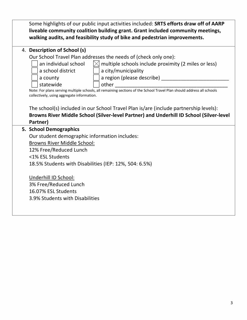
Some highlights of our public input activities included: SRTS efforts draw off of AARP liveable community coalition building grant. Grant included community meetings, walking audits, and feasibility study of bike and pedestrian improvements.
4. Description of School (s)
Our School Travel Plan addresses the needs of (check only one): an individual school multiple schools include proximity (2 miles or less) a school district a city/municipality a county a region (please describe) ________________________ statewide other ________________________________________
Note: For plans serving multiple schools, all remaining sections of the School Travel Plan should address all schools collectively, using aggregate information.
The school(s) included in our School Travel Plan is/are (include partnership levels): Browns River Middle School (Silver-level Partner) and Underhill ID School (Silver-level Partner)
5. School Demographics Our student demographic information includes: Browns River Middle School: 12% Free/Reduced Lunch <1% ESL Students 18.5% Students with Disabilities (IEP: 12%, 504: 6.5%) Underhill ID School: 3% Free/Reduced Lunch 16.07% ESL Students 3.9% Students with Disabilities

4
6. Current School Travel Environment The following was collected using the student travel tally conducted the week of September 24, 2012. This is how our students travel to and from school:
Travel Mode
Walk Bike School Bus
Family Vehicle
Carpool Public Transit
Other
UID 2% 2% 45% 49% 1% 0% 0.5% BRMS 5% 2% 51% 43% 0% 0% 0%
These are the distances our students live from school:
School Total Students Geocoded
# students within 2 miles
% students within 2 miles
#students within 1 mile
% students within 1 mile
BRMS 415 92 22% 56 13%
UID 113 103 91% 67 59%
Combined 528 195 37% 123 23%
We have the following supports or activities in place during student travel times (check each that applies):
crossing guards student patrol parent patrol staff presence during drop-off/pick-up Walking School Bus Bike Train police department support Neighborhood Watch program Other____________________
crime or violence prevention program school traffic safety plan
Our school arrival procedures: Arrival plan is the same no matter how the student gets to school. They are dropped off or arrive at the front entrance - buses use the bus lane. Students are greeted at the school entrance by staff. Our school dismissal procedures:
For pedestrians & bicyclists Walkers and bicyclists are dismissed at the second bell For school buses Bus students are dismissed at the bell that sounds closest to the time of their
bus run. Designated staff waits outside to supervise the bus lines. For carpools
Students who get rides in carpools or as a single rider in a private vehicle can be picked up in front of school or in the parking lot. For private vehicle drop-
off/pick-up

5
For teachers and staff There are no special procedures for staff arrival and dismissal. Our school (does) (does not) provide bus service to students. Bus service is provided to all children Our school is already engaged in activities that enhance safe and active student travel including:
Supervised walking school buses (3) organized for Walk to School Day events each month (the first Friday of each month) and lead by parents and staff members
7. Barriers to Active Transportation
We have identified and prioritized the following barriers to walking and bicycling to school (check each that applies, and circle its importance as ‘high’, ‘medium’, or ‘low’):
Distance (high) (medium) (low) Convenience of driving (high) (medium) (low) Time (high) (medium) (low) Child’s before and after-school activities (high) (medium) (low) Speed along traffic route (high) (medium) (low) Amount of traffic along route (high) (medium) (low) Adults to walk or bike with (high) (medium) (low) Sidewalks or pathways (high) (medium) (low) Safety of intersections and crossings (high) (medium) (low) Crossing guards (high) (medium) (low) Violence or crime (high) (medium) (low) Weather or climate (high) (medium) (low) Other Gaps in pedestrian accommodations on route 15. Including lack of sidewalks
and unsafe crossings (high) (medium) (low) This information was captured in our parent surveys. Date Parent Survey was administered in September 2012. Following is some detail regarding each specific barrier we have identified, including locations and characteristics of specific situations: See Appendix B: Location-Specific Engineering Recommendations

6
8. Traffic Counts
Below are the traffic counts that have been taken around our school:
N/A Location ADT Counts Classification Speed
Limit Average 85th
Percentile River Road 3,500 VPD Class 2 25 mph Eastbound:
37mph Westbound: 36mph
Eastbound: 42mph Westbound: 43mph
Route 15 North of River Rd and South of Park Street: 11,400 VPD
State Highway
35 mph 36 mph Northbound: 42mph Southbound: 41mph
Dickenson Road
100 VPD* Class 3* 25 mph*
*Numbers sourced from the 2010 Dickinson Street Scoping Study. Remaining numbers were sourced from the VT 15 2014 SRTS/Bicycle Pedestrian Scoping Study
9. Creating Solutions
Goals Our primary goal(s) for active school transportation are to:
• Increase the number of students walking and bicycling to school; • Improve the safety walking and bicycling routes to school.
Strategies We have identified strategies involving the 5 “E’s” of Safe Routes to School to address the barriers to walking and bicycling in our community and to achieve our stated goals. We have selected at least one strategy from each of the categories of Education, Encouragement, Enforcement and Evaluation, in addition to any Engineering strategies that are indicated. The strategies we are working on include:
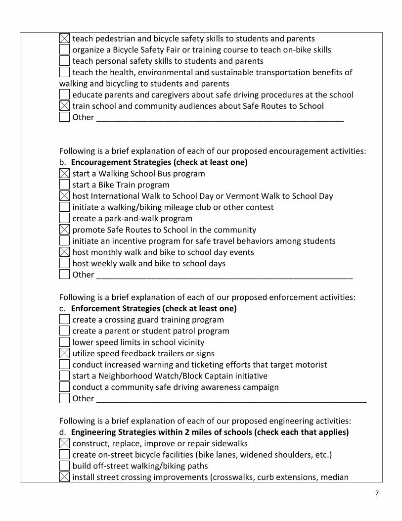
Following is a brief explanation of each of our proposed education activities: a. Education Strategies (check at least one)
7
teach pedestrian and bicycle safety skills to students and parents organize a Bicycle Safety Fair or training course to teach on-bike skills teach personal safety skills to students and parents teach the health, environmental and sustainable transportation benefits of
walking and bicycling to students and parents educate parents and caregivers about safe driving procedures at the school train school and community audiences about Safe Routes to School Other ______________________________________________________
Following is a brief explanation of each of our proposed encouragement activities: b. Encouragement Strategies (check at least one)
start a Walking School Bus program start a Bike Train program host International Walk to School Day or Vermont Walk to School Day initiate a walking/biking mileage club or other contest create a park-and-walk program promote Safe Routes to School in the community initiate an incentive program for safe travel behaviors among students host monthly walk and bike to school day events host weekly walk and bike to school days Other ________________________________________________________
Following is a brief explanation of each of our proposed enforcement activities: c. Enforcement Strategies (check at least one)
create a crossing guard training program create a parent or student patrol program lower speed limits in school vicinity utilize speed feedback trailers or signs conduct increased warning and ticketing efforts that target motorist start a Neighborhood Watch/Block Captain initiative conduct a community safe driving awareness campaign Other ___________________________________________________________
Following is a brief explanation of each of our proposed engineering activities: d. Engineering Strategies within 2 miles of schools (check each that applies)
construct, replace, improve or repair sidewalks create on-street bicycle facilities (bike lanes, widened shoulders, etc.) build off-street walking/biking paths install street crossing improvements (crosswalks, curb extensions, median

8
refuges, raised crossings, pedestrian bridges or tunnels) install new or improved lighting for walkways or bikeways install new or improved signage (school zone, speed limits, crosswalk) install new or improved pavement markings or legends make existing walkways accessible to disabled students install bike parking near schools (bike racks, bike lockers, covered shelters) install traffic calming or speed reduction measures (curb extensions, speed
humps, traffic circles, raised crosswalks, narrowing lanes, street closures) install traffic control devices (traffic signals, pedestrian signals, flashing beacons) design pick-up and drop-off procedures to increase safety and access divert traffic away from school zone or designated routes winter maintenance to keep walk and bike routes clear Other___________________________________________________________ engineering strategies are not indicated at this time for our community.
Following is a brief explanation of each of our proposed evaluation activities: e. Evaluation Strategies (check at least one) To gauge the success of our efforts, we collected data both before and after implementing our strategies. We are measuring the impact of our school travel plan by (check at least one):
conducting the student tally (measure model change among students) conducting the parent survey (measuring parent/guarding perceptions) conducting traffic counts conducting bicycle and pedestrian counts obtaining planning services for expanding or improving an existing SRTS plan we have developed additional safety evaluation measures that include:
Evaluation Method “Before” Measure and Date Collected Use student tally to count number of walking and bicycling students at both BRMS and Underhill ID
Date(s): % Walking: 4.0% % Bicycling: 2.0%
Measure parent perceptions of safety using parent survey
Date: Top 3 concerns: 1) Speed of Traffic Along Route - 94% 2)Amount of Traffic Along Route - 85% 3)Safety of Intersections and Crossings - 68%
10. Improvements Mapping See Appendix A: Underhill ID/Browns River Middle School Infrastructure Location Key
9
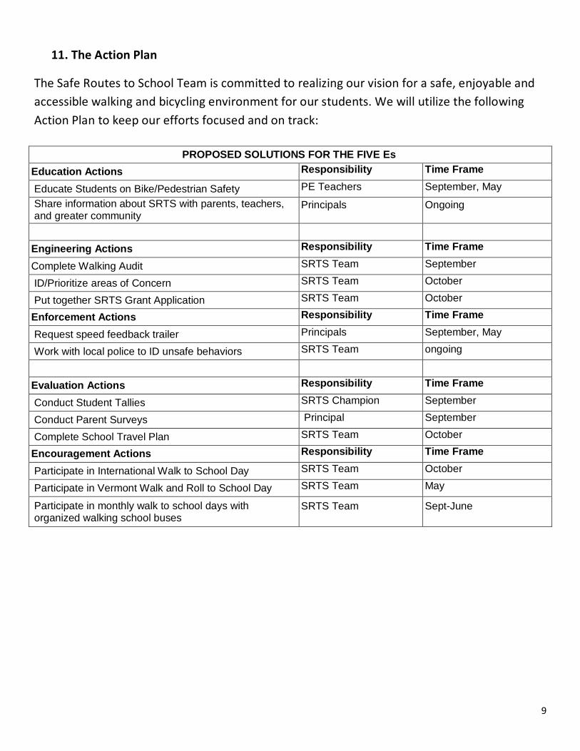
11. The Action Plan
The Safe Routes to School Team is committed to realizing our vision for a safe, enjoyable and accessible walking and bicycling environment for our students. We will utilize the following Action Plan to keep our efforts focused and on track:
PROPOSED SOLUTIONS FOR THE FIVE Es Education Actions Responsibility Time Frame
Educate Students on Bike/Pedestrian Safety PE Teachers September, May Share information about SRTS with parents, teachers, and greater community
Principals Ongoing
Engineering Actions Responsibility Time Frame
Complete Walking Audit SRTS Team September
ID/Prioritize areas of Concern SRTS Team October
Put together SRTS Grant Application SRTS Team October
Enforcement Actions Responsibility Time Frame
Request speed feedback trailer Principals September, May
Work with local police to ID unsafe behaviors SRTS Team ongoing
Evaluation Actions Responsibility Time Frame
Conduct Student Tallies SRTS Champion September
Conduct Parent Surveys Principal September
Complete School Travel Plan SRTS Team October
Encouragement Actions Responsibility Time Frame
Participate in International Walk to School Day SRTS Team October
Participate in Vermont Walk and Roll to School Day SRTS Team May
Participate in monthly walk to school days with organized walking school buses
SRTS Team Sept-June
10
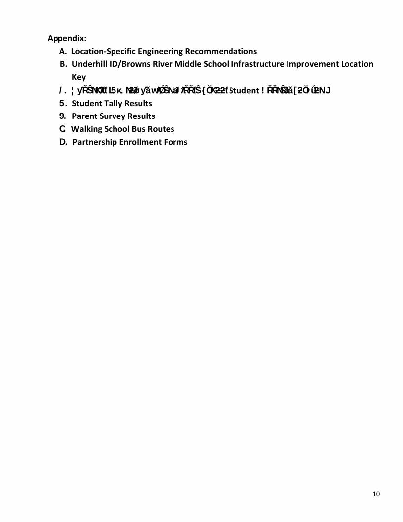
Appendix: A. Location-Specific Engineering Recommendations
9. Parent Survey Results C. Walking School Bus Routes D. Partnership Enrollment Forms
B. Underhill ID/Browns River Middle School Infrastructure Improvement Location Key
5. Student Tally Results /. ¦ƴŘŜNJƘƛƭƭ L5κ.NJƻǿƴǎ wƛǾŜNJ aƛŘŘƭŜ {ŎƘƻƻƭ Student !ŘŘNJŜǎǎ [ƻŎŀǘƻNJ
AVillere
Cross-Out

Appendix A: Location-Specific Engineering Recommendations SRTS engineering strategies create safer environments for walking and bicycling to school through improvements to the infrastructure surrounding schools. These improvements focus on reducing motor vehicle speeds and conflicts with pedestrians and bicyclists, and establishing safer and fully accessible crossings, walkways, trails and bikeways. The following table provides a summary of engineering strategies recommended for Underhill ID & Browns River Middle Schools. These recommendations were developed by Broadreach Planning & Design and Toole Design Group, LLC based on input from the UID/BRMS SRTS Team. The table includes an estimate of the amount of time that is likely to be needed to implement the recommended improvements at each site (Estimated Time Frame). These recommendations are for planning purposes only and may require further engineering analysis, design, or public input before implementation and shall be in full compliance with the Manual on Uniform Traffic Control Devices for Streets and Highways, (MUTCD) 2009 Edition. VTrans District Office staff will be involved in the planning and design process for any recommendation made on the state system. The summary table provided below is followed by information about implementation and a map, which shows where the recommendation sites are located in relation to the school.
1

Street Classifications and Descriptions
2
Location ADT Counts Classification Speed Limit
Average 85th Percentile
River Road 3,500 VPD Class 2 25 mph Eastbound: 37mph Westbound: 36mph
Eastbound: 42mph Westbound: 43mph
Route 15 North of River Rd and South of Park Street: 11,400 VPD
State Highway 35 mph 36 mph Northbound: 42mph Southbound: 41mph
Dickenson Road 100 VPD* Class 3* 25 mph* N/A N/A
*Numbers sourced from the 2010 Dickinson Street Scoping Study. Remaining numbers were sourced from the VT 15 2014 SRTS/Bicycle Pedestrian Scoping Study

Site Need Recommendation
Time Frame
Ranking Factors
Team Priority
A. Intersection of Route 15 & River Road This is a “T” intersection. Traffic on River Road is stop-controlled. River Road intersects with a curve in Route 15. The intersection is comprised of two travel lanes each on River Road and Route 15. An existing crosswalk across Route 15 and south of the intersection connects the sidewalk on the SE side of river road with the sidewalk on the W side of Route 15.
The curve of Route 15 creates limited sightlines for pedestrians using the crosswalk and motor vehicles exiting River Road onto Route 15. Signage for the existing crosswalk is located in awkward locations.
A1. Undertake a feasibility study to reorganize the intersection, re-examine the need for a crosswalk on Route 15 and, if appropriate, identify a new location for a crosswalk and associated signage.* *Please note, as the recommendation falls on a state route, all proposed projects require approval from the VTrans District Office.
Short term
Safety concerns. Existing walking or
bicycling routes. Priorities for the
school community.
High Priority
3

Site Need Recommendation
Time Frame
Ranking Factors
Team Priority
B. Intersection of Route 15 and Dickinson Street. This is a “T” intersection. Traffic on Dickinson Street is stopped controlled. There are existing sidewalks along the north side of Route 15 from River Road to Palmer Lane. Dickinson Street is a 16’, low-volume, one-way road. The two ends at the Route 15 and River Road intersections are paved and include paved shoulders. The middle portion of the road between the intersections is gravel.
Dickinson Street provides a direct walking and bicycling link to the school grounds for students living along Route 15 and in the subdivisions on the opposite side of Route 15. A sidewalk has been funded along Route 15 to connect Palmer Lane with Park Street. This will complete the pedestrian linkage on Route 15 between River Road and Park Street. There is no crosswalk on Route 15 at the Dickinson Street intersection. The high traffic volumes and the observed average speed of drivers over the posted speed limit makes crossing Route 15 without a crosswalk difficult.
B1. Install a high-visibility, durable, ladder-style crosswalk across Route 15 at the intersection with Dickinson Street.
Short term
Safety concerns. Existing walking
or bicycling routes
Priorities for the
school community.
High Priority
B2. Install an ADA-compliant curb ramp on the existing sidewalk to align with the north side of the proposed crosswalk and an appropriate landing on the Dickinson Street wide paved shoulder to link with the south side of the crosswalk proposed in B1.
B3. Install a rectangular rapid flashing beacon (RRFB) at the new crosswalk on Route 15 at the Dickinson Street intersection.
4

Site Need Recommendation
Time Frame
Ranking Factors
Team Priority
C. River Road River Road is a town road approximately 24-feet wide with two 12-foot travel lanes. The posted speed limit is 35 mph and 25 mph within the existing school zone in front of the school campus. There is a sidewalk on the south side of the road from Route 15 to the school campus and one on the north side from the campus to Park Street. There is an existing crosswalk southwest of the intersection with Dickinson Street.
River Road is part of a direct walking route for students coming to the school grounds and is also regularly used by motorists in the mornings and evenings. Most students come from the north side of the road and cross the road to get to the sidewalk that leads to the school. The crosswalk is located at a convenient location for the students using it. However, the location makes it difficult for drivers to see students, especially when students are heading away from the school. Nearby slopes and wetlands make it difficult to relocate the sidewalks. Vehicles on River Road have been measured at speeds an average of 10 MPH higher than the posted speed limit with the 85th percentile traveling at more than 20 MPH over the speed limit. Drivers often do not have time to see pedestrians and stop for them in the existing crosswalk.
C1. Restripe the existing crosswalk on River Road near the Dickinson Street intersection with a high-visibility, durable, ladder-style crosswalk.
Short term
Safety concerns. Existing walking
or bicycling routes Priorities for the
school community.
High Priority
C2. Install ADA-compliant curb ramps at either end of both crosswalks at the intersection of Dickinson Street and River Road.
Short Term
C3. Install a rectangular rapid flashing beacon (RRFB) at the restriped crosswalk on River Road.
Short Term
C4. Install ‘SCHOOL’ pavement markings on River Road at either end of the school zone - one before the curve in the road near the Dickinson Street intersection and one close to the intersection with Route 15.
Short Term
C5. Install ‘SCHOOL’ (S1-1) signs with ‘AHEAD’ (W16-9P) plaque on River Road approximately 200-ft east of the east entrance to the campus and west of the west entrance to the campus.
Short Term
C6. Obtain and permanently post two speed feedback signs on River Road at either end of the school zone.
Short Term
5

Site Need Recommendation
Time Frame
Ranking Factors
Team Priority
C. River Road (continued)
C7. Install a sidewalk segment (approx. 350-ft) on the north side of River Road from Park Street to Maple Ridge Road.
Medium term
Safety concerns. Existing walking
or bicycling routes Priorities for the
school community.
High Priority
C8. Install a curb radius reduction on the east and west sides of Park Street at the intersection of River Road, install ADA-compliant accessible ramps and restripe existing crosswalk with a high-visibility, durable, ladder-style crosswalk.
Medium term
C9. Install a lane diet by reducing the travel lane width on River Road to 10-ft travel lanes with 2-ft solid white edge lines from Route 15 to Lower English Settlement Road. * *Note: Investigate the opportunity to plant street trees between the sidewalk and roadway limits.
Medium term
6

Site Need Recommendation
Time Frame
Ranking Factors
Team Priority
D. Dickinson Street Dickinson Street is a 16’, low-volume, one-way road with approx. 3-foot paved shoulders on either side of the road close to the Route 15 intersection for use by pedestrians. A pathway on the north side of River Road crosses Dickinson Street just north of the intersection of the two streets. The path continues on the SW side of Dickinson Street and crosses River Road to provide a connection to the school grounds.
Dickinson Street provides a direct walking and bicycling link to the school grounds for students living along Route 15 and in the subdivisions on the opposite side of Route 15. The existing shoulders on Dickinson Street are too narrow to act as an appropriate pedestrian facility despite their frequent use as such by the community. The pathway at the intersection of Dickinson Street and River Road is currently in a state of disrepair and not ADA-compliant.
D1. Restripe the existing paved portions of Dickinson Street with an ADA-compliant 5-foot shoulder on the south side of the road to provide appropriate space for pedestrians.
Short term
Safety concerns. Existing walking
or bicycling routes Priorities for the
school community.
High Priority
D2. Reconstruct the existing pathway that crosses Dickinson Street to provide ADA-compliant ramps on either side of the crossing.
Medium term
7
Site Need Recommendation
Time Frame
Ranking Factors
Team Priority
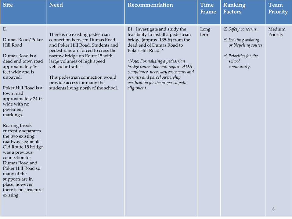
E. Dumas Road/Poker Hill Road Dumas Road is a dead end town road approximately 16-feet wide and is unpaved. Poker Hill Road is a town road approximately 24-ft wide with no pavement markings. Roaring Brook currently separates the two existing roadway segments. Old Route 15 bridge was a previous connection for Dumas Road and Poker Hill Road so many of the supports are in place, however there is no structure existing.
There is no existing pedestrian connection between Dumas Road and Poker Hill Road. Students and pedestrians are forced to cross the narrow bridge on Route 15 with large volumes of high speed vehicular traffic. This pedestrian connection would provide access for many the students living north of the school.
E1. Investigate and study the feasibility to install a pedestrian bridge (approx. 135-ft) from the dead end of Dumas Road to Poker Hill Road. * *Note: Formalizing a pedestrian bridge connection will require ADA compliance, necessary easements and permits and parcel ownership verification for the proposed path alignment.
Long term
Safety concerns. Existing walking
or bicycling routes Priorities for the
school community.
Medium Priority
8

North
BRMS AND UID LOCATION MAP 1 OF 2 School Location Segment Improvement
Intersection/Spot Improvement
A1
C4, C5,C6
C4, C5,C6
Jericho/Underhill, VTSpring 2014
Park Street
D1B1, B2,
B3
D2
Underhill ID School
Browns RiverMiddle School
C1, C2,C3 River Road
Dickinson StreetRaceway Road
Creekside Road
Maple Ridge Road
C7C8
AVillere
Typewritten Text
Appendix B: Infrastructure Improvement Location Key

North
Underhill ID School
Browns RiverMiddle School
C9
E1
Jericho/Underhill, VTSpring 2014
School Location Segment Improvement
Intersection/Spot Improvement
BRMS AND UID LOCATION MAP 2 OF 2
Dickenson St
Harv
est R
un
Lowe
r Eng
lish
Settl
emen
t Rd
Maple Ridge Rd
River Rd
Park St
Cham
berli
n Wo
ods
Dum
as R
dMead
ow Ln
Poker Hill Rd
Palmer Ln
Raceway Rd
Farmhouse Rd

1.5 mile
1 mile
.5 mile
.25 mile
2 2
22
22
2
2
2
2
2
22
2
2
2
2
3
3
3
3
Underhill ID and Browns River Middle School Student Address LocatorJericho, VTOctober 2012
North
0 0.2 0.40.1Miles
2
22
2
22
UID Student Residence
Multiple UID Student Residences
Underhill ID School (UID)
BRMS Student Residence
Multiple BRMS Student Residences
Browns River Middle School (BRMS)
Appendix C: Student Address Locator

Tally Report SummaryProgram Name: Underhill ID/BRMS Month and Year Collected: October 2012
School Name: Underhill ID School Set ID: 10500
School Enrollment: 114 Date Report Generated: 10/25/2012
Enrollment within Grades Targeted by SRTS Program: 114 Number of ClassroomsIncluded in Report:
7
Number of Classrooms in School: 6
This report contains information from parents about their children's trip to and from school. The data used in this report were collected using thein-class Student Travel Tally questionnaire from the National Center for Safe Routes to School.
Morning and Afternoon Travel Mode Comparison
Morning and Afternoon Travel Mode Comparison
Numberof Trips Walk Bike School
BusFamilyVehicle Carpool Transit Other
Morning 194 2% 2% 45% 49% 1% 0% 0.5%
Afternoon 0 0% 0% 0% 0% 0% 0% 0%
Percentages may not total 100% due to rounding.
Page 1 of 3
AVillere
Typewritten Text
Appendix D: Student Tally Results

Morning and Afternoon Travel Mode Comparison by Day
Morning and Afternoon Travel Mode Comparison by Day
Number ofTrips Walk Bike School Bus Family
Vehicle Carpool Transit Other
Tuesday AM 102 2% 2% 42% 52% 1.0% 0% 1.0%
Tuesday PM 0% 0% 0% 0% 0% 0% 0%
Wednesday AM 92 2% 1% 49% 47% 1% 0% 0%
Wednesday PM 0% 0% 0% 0% 0% 0% 0%
Thursday AM 0% 0% 0% 0% 0% 0% 0%
Thursday PM 0% 0% 0% 0% 0% 0% 0%
Percentages may not total 100% due to rounding.
Page 2 of 3

Travel Mode by Weather Conditions
Travel Mode by Weather Condition
WeatherCondition
Numberof Trips Walk Bike School
BusFamilyVehicle Carpool Transit Other
Sunny 194 2% 2% 45% 49% 1% 0% 0.5%
Rainy 0 0% 0% 0% 0% 0% 0% 0%
Overcast 0 0% 0% 0% 0% 0% 0% 0%
Snow 0 0% 0% 0% 0% 0% 0% 0%
Percentages may not total 100% due to rounding.
Page 3 of 3

VT SRTS Student Travel Tally Form
Response ID: Data
2. School Information
1. Your contact Information
Name : Suzanne McDevittEmail address : [email protected]
2. School Name
Browns River Middle School
3. Name of School
3. Please mark all the grades included at your school. (Please note that the VT SRTS program only records data forgrades PK-8th)
FifthSixthSeventhEighth
4. Total enrollment for the school (please only include enrollment for grades PK-8)
398
3. Day 1: Student Travel Tally Data
5. On what date was this student travel mode data collected? (dd/mm/yyyy)
09/26/2012
6. Describe the weather conditions on the day that you collected the data
Rainy
7. How many students walked on day 1? Record the number of walkers by grade.
PK K 1 2 3 4 5 6 7 8
# of walkers 2 5 1 2
8. How many students biked on day 1? Record the number of bicyclists by grade.
PK K 1 2 3 4 5 6 7 8
# of bicyclists 1 1 1
4. Day 1: Data sdfsdfsdf
9. On what date was this student travel mode data collected? (dd/mm/yyyy)
09/27/2012
10. Describe the weather conditions on the day that you collected the data
Sunny
11. How many students walked on day 2? Record the number of walkers by grade.

PK K 1 2 3 4 5 6 7 8
# of walkers 4 3 1 9
12. How many students biked on day 2? Record the number of bicyclists by grade.
PK K 1 2 3 4 5 6 7 8
# of bicyclists 6 2
5. Thank You!
Email confirmation
Oct 17, 2012 13:27:35 Success: Email Sent to: [email protected]
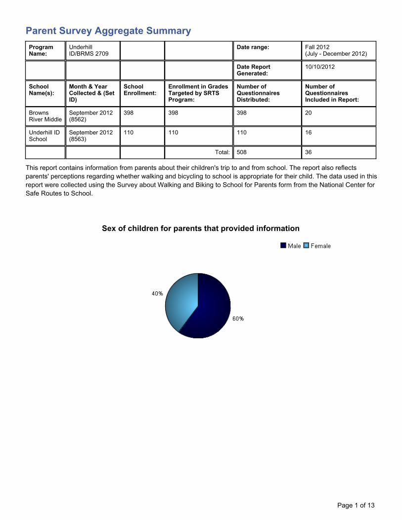
Parent Survey Aggregate SummaryProgramName:
UnderhillID/BRMS 2709
Date range: Fall 2012(July - December 2012)
Date ReportGenerated:
10/10/2012
SchoolName(s):
Month & YearCollected & (SetID)
SchoolEnrollment:
Enrollment in GradesTargeted by SRTSProgram:
Number ofQuestionnairesDistributed:
Number ofQuestionnairesIncluded in Report:
BrownsRiver Middle
September 2012(8562)
398 398 398 20
Underhill IDSchool
September 2012(8563)
110 110 110 16
Total: 508 36
This report contains information from parents about their children's trip to and from school. The report also reflectsparents' perceptions regarding whether walking and bicycling to school is appropriate for their child. The data used in thisreport were collected using the Survey about Walking and Biking to School for Parents form from the National Center forSafe Routes to School.
Sex of children for parents that provided information
Page 1 of 13
AVillere
Typewritten Text
Appendix E: Parent Survey Results

Grade levels of children represented in survey
Grade levels of children represented in survey
Grade in SchoolResponses per
grade
Number Percent
Kindergarten 4 11%
1 1 3%
2 4 11%
3 2 6%
4 5 14%
5 4 11%
6 3 9%
7 6 17%
8 6 17%
No response: 0Percentages may not total 100% due torounding.
Page 2 of 13

Parent estimate of distance from child's home to school
Parent Survey Aggregate Summary
Distance betweenhome and school Number of children Percent
Less than 1/4 mile 0 0%
1/4 mile up to 1/2 mile 7 19%
1/2 mile up to 1 mile 4 11%
1 mile up to 2 miles 15 42%
More than 2 miles 10 28%
Don't know or No response: 0Percentages may not total 100% due to rounding.
Page 3 of 13

Typical mode of arrival at and departure from school
Typical mode of arrival at and departure from school
Time of Trip Numberof Trips Walk Bike School
BusFamilyVehicle Carpool Transit Other
Morning 36 3% 0% 56% 39% 3% 0% 0%
Afternoon 36 6% 0% 50% 39% 3% 0% 3%
No Response Morning: 0No Response Afternoon: 0Percentages may not total 100% due to rounding.
Page 4 of 13

Typical mode of school arrival and departure by distance child lives from school
Page 5 of 13

Typical mode of school arrival and departure by distance child lives from school
School Arrival
Distance Number withinDistance Walk Bike School
BusFamilyVehicle Carpool Transit Other
Less than 1/4 mile 0 0% 0% 0% 0% 0% 0% 0%
1/4 mile up to 1/2 mile 7 14% 0% 57% 29% 0% 0% 0%
1/2 mile up to 1 mile 4 0% 0% 75% 25% 0% 0% 0%
1 mile up to 2 miles 15 0% 0% 40% 60% 0% 0% 0%
More than 2 miles 10 0% 0% 70% 20% 10% 0% 0%
Don't know or No response: 0Percentages may not total 100% due to rounding.
School Departure
Distance Number withinDistance Walk Bike School
BusFamilyVehicle Carpool Transit Other
Less than 1/4 mile 0 0% 0% 0% 0% 0% 0% 0%
1/4 mile up to 1/2 mile 7 14% 0% 57% 14% 0% 0% 14%
1/2 mile up to 1 mile 4 0% 0% 50% 50% 0% 0% 0%
1 mile up to 2 miles 15 7% 0% 40% 47% 7% 0% 0%
More than 2 miles 10 0% 0% 60% 40% 0% 0% 0%
Don't know or No response: 0Percentages may not total 100% due to rounding.
Page 6 of 13

Percent of children who have asked for permission to walk or bike to/from school bydistance they live from school
Percent of children who have asked for permission to walk or bike to/from school bydistance they live from school
Asked Permission? Number of Children Less than1/4 mile
1/4 mile upto 1/2 mile
1/2 mile upto 1 mile
1 mile upto 2 miles
More than2 miles
Yes 16 0% 57% 50% 40% 40%
No 20 0% 43% 50% 60% 60%
Don't know or No response: 0Percentages may not total 100% due to rounding.
Page 7 of 13

Issues reported to affect the decision to not allow a child to walk or bike to/from school byparents of children who do not walk or bike to/from school
Issues reported to affect the decision to allow a child to walk or bike to/from school byparents of children who already walk or bike to/from school
Page 8 of 13

Issues reported to affect the decision to allow a child to walk or bike to/from school byparents of children who already walk or bike to/from school
Issue Child does not walk/bike to school Child walks/bikes to school
Speed of Traffic Along Route 94% 0%
Amount of Traffic Along Route 85% 50%
Safety of Intersections and Crossings 68% 50%
Sidewalks or Pathways 65% 50%
Crossing Guards 41% 50%
Distance 32% 100%
Weather or climate 29% 50%
Time 21% 0%
Adults to Bike/Walk With 12% 0%
Violence or Crime 12% 0%
Child's Participation in After School Programs 3% 0%
Convenience of Driving 0% 0%
Number of Respondents per Category 34 2
No response: 0Note:--Factors are listed from most to least influential for the 'Child does not walk/bike to school' group.--Each column may sum to > 100% because respondent could select more than issue--The calculation used to determine the percentage for each issue is based on the 'Number of Respondents per Category' withinthe respective columns (Child does not walk/bike to school and Child walks/bikes to school.) If comparing percentages betweenthe two columns, please pay particular attention to each column's number of respondents because the two numbers can differdramatically.
Page 9 of 13
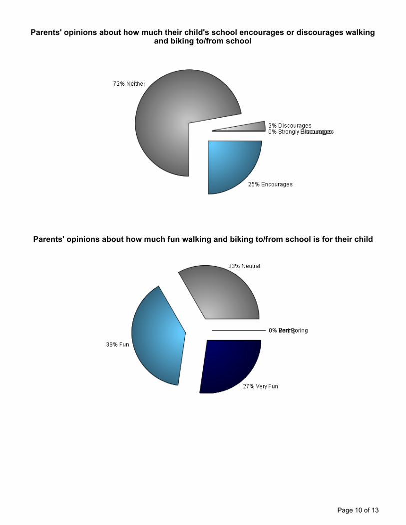
Parents' opinions about how much their child's school encourages or discourages walkingand biking to/from school
Parents' opinions about how much fun walking and biking to/from school is for their child
Page 10 of 13

Parents' opinions about how healthy walking and biking to/from school is for their child
Page 11 of 13

Comments Section
School SurveyID Comment
BrownsRiverMiddle
897297 Route 15 is too unsafe for any student K-8 to ride a bike on. It is my opinion at this time that no studentat UID or BRMS should be encouraged by the schools to ride a bicycle on Rt. 15 - the shoulder alongthe route is narrow, the traffic is very heavy during the commute time to school, and far too many driversare distracted (particularly by cell phone texting - I experience, multiple times daily, drivers on Rt. 15looking down in the direction of their laps where their cell phone sits, clearly reading and writing texts). Ifthere were a bike path constructed parallel to it, that would be the only safe option for biking to schoolfrom our neighborhood.
BrownsRiverMiddle
897298 If there was a multi use rec path from JES to Mills River--My child would ride as weather allowed. If thesidewalk that now ends at griswold continued to MRP, he would ride. If the intersection of 15 andBrowns trace were not so dangerous, I would probably let him ride now.
BrownsRiverMiddle
897301 We need safe places to cross Rt.15
BrownsRiverMiddle
897320 If we could get school crossing guards by the Jolly store to allow kids to get across route 15 I'd let mekids walk or bike to school. Traffic just moves too fast and is too congested at that hour of the morning.
BrownsRiverMiddle
897322 I would feel better about my child biking if there was an alternative to them having to ride on Rte 15. Ifthey could get from Poker Hill to Meadow lane to Park Street to BRMS without riding on Rte 15,it wouldbe 100X safer.
BrownsRiverMiddle
897336 If we had a sidewalk from Mills Riverside to Poker Hill I think a lot more students would ride bikes toschool. As it stands now, 15 is way too dangerous for kids.
BrownsRiverMiddle
897392 Rural living with roadways that are too narrow to feel safe riding or walking. Path would be wonderfulbut....
BrownsRiverMiddle
897424 Anytime my son wants to ride his bike to school, I am all for it. The benefits far outweigh any risks. I thinkparents in general are too uptight about this, and should let go a little.
BrownsRiverMiddle
897481 If there were sidewalks to at least Poker Hill Road my son would walk or ride his bike to school mostdays (weather permitting). I am more likely to let him walk home from school now as the traffic in themorning is so heavy and he would be walking on the side of the road for half the trip
BrownsRiverMiddle
897495 The route to BRMS from our house includes over 2 miles along rt 15, which renders walking or biking toschool completely untenable. There is pretty much nothing that could be done to make this a viable option.
BrownsRiverMiddle
897537 Having better, safer routes between the local neighborhoods and the schools (JES, UID, BRMS andMU) would be ideal for so many reasons, not the least of which is getting to/from school - but also theability to meet friends, attend events, and extend the use of these facilities beyond the school day. Wedesperately need safer routes.
BrownsRiverMiddle
906614 It would be wonderful to have a crossing guard at the intersection of Dickenson Street again to crosschildren on Route 15
BrownsRiverMiddle
906703 If there was a culture of walking in the Underhill Flats area, the numbers of walkers to school wouldgrow. There are gaps in safe pedestrian access to school, namely in designated pedestrian/bicyclewalkways and safe cross walks.
BrownsRiverMiddle
906724 If my child could safely walk to and from school, she would definitely do it. Speed, traffic and nosidewalks are the reasons that she does not.
UnderhillID School
897573 We need a sidewalk along rte. 15 so that is is safe for us to walk along that busy route. I would love tobe able to walk and/or bike back and forth to school but unfortunatly it is not a safe environment for mychildren without a sidewalk.
Page 12 of 13

UnderhillID School
903839 i would love to see a bikepath system along route 15 and brown's trace that ultimately connectsUID/BRMS/mills riverpark with MMU and Jerico circle or at least a path along route 15.
UnderhillID School
903840 i would love to see a bikepath system along route 15 and brown's trace that ultimately connectsUID/BRMS/mills riverpark with MMU and Jerico circle or at least a path along route 15.
UnderhillID School
904389 I would love for my child to bike to school but the route is a death wish. Even in a car it's dangerous. Isee families walking trying to cross the road and it's almost impossible. There are no safe side walks thetraffic gets backed up so drivers take unsafe risks to get onto 15. As an adult I don't feel safe walking inthe village so I would never even consider it for my child unless drastic changes were implemented
UnderhillID School
904409 Route 15 is very unsafe I would suggest a drop off along Route 15 at the sawmill so parents do nothave to drive in and out of the school driveway and try to get back on Route 15 by Jolleys. Kids cancross the road with a crossing guard and be at school safely.
UnderhillID School
906470 I would allow my child to bike or walk if there were a crossing guard so that I knew she could safely crossVermont route 15 and River Road to get to school.
UnderhillID School
906594 Crossing Rt. 15 is THE reason we don't walk/bike to school. I think that a crossing guard at theRaceway/Lumber yard cross would lead to many kids in the neighborhoods off of Raceway to walking orbiking to school. Similarly, if there was a sidewalk or path from Jericho East to theDRML/UID/BRMS/Mills River area, that would be a huge boon.
UnderhillID School
907418 If there was a bike/walk path adjacent to Rte.15 but separated from the vehicle travel lanes then wewould gladly allow our children to walk/bike to school.
Page 13 of 13

JERICHOUNDERHILL
Raceway Rd
Brookside Dr
Sugar Hill
Meadow Ln
Palmer Ln
Palmer Ln
Liberty Ln
Maple Ridge R d
Dickenson St
Park St
7:40
7:40
7:407:40
7:40
7:357:35
7:307:30
MillsMillsRiverside
RiversideParkPark
United Church
United Church
United Church
of Underhill
of Underhill
Underhill Post O
ffice
Underhill Post O
ffice
Green CrowGreen Crow
LumberyardLumberyard
Underhill
Flats
CemeteryUnderhill
Flats
Cemetery
7:50
Underhill ID Elementary School & Browns River Middle School Walking School Bus RoutesJericho, VTWinter 2013
LEGEND
Underhill IDElementarySchool
Pickup Location
Starting Location
Walking SchoolBus Routes
Departure Time7:## 7:##
Follow these tips to make your walk or ride to school safe!
1. Walk to school in groups if possible.2. Always walk on the sidewalk if one is available.3. If no sidewalk is available, walk facing traffic.4. Wear bright and reflective clothing so cars can see you.5. Before you step off the curb to cross the street, stop and look left-right-left and wait until no cars are coming.6. Always wear your helmet when biking.
River Rd
AVillere
Typewritten Text
Appendix F: Walking School Bus Routes

AVillere
Typewritten Text
Appendix G: Partnership Enrollment Forms
AVillere
Typewritten Text