Vehicle Monitoring System for Accident Detection
5
International Journal of Science and Research (IJSR) ISSN (Online): 2319-7064 Index Copernicus Value (2013): 6.14 | Impact Factor (2015): 6.391 Volume 5 Issue 5, May 2016 www.ijsr.net Licensed Under Creative Commons Attribution CC BY Vehicle Monitoring System for Accident Detection Priyanka P. Chaudhari 1 , Dr. R. B. Naik 2 1 ME Software Engineering Student, MIT., Dr. BAM University, Aurangabad, India 2 Professor, Marathwada Institute of Technology, Dr. BAM University, Aurangabad, India Abstract: In highly populated Countries just like India, in accidents, people lose their lives due to unavailability of proper medical facilities at the right time. This project senses any accident in the vehicle and intimates pre-programmed numbers like the owner of the vehicle, ambulance, police etc. The Global System for Mobile (GSM) technology is used to send the position of the vehicle as a Short Message Service to those numbers. And also the position of the vehicle can be obtained by the owner of the vehicle or anyone with proper permission by sending a Short Message Service to a number. Most of the companies require keeping track of their vehicles, with this equipment we can keep track of the vehicle by periodically sending Short Message Service and the position of the vehicle is sent by the GSM modem as a SMS to the user. To know the position of the vehicle, the owner sends a request through a SMS. This is received by a GSM modem in the device and processed by the processor and the processor sends command to a Global Positioning System (GPS) module in the device. The GPS module responds with co - ordinates position of the vehicle. This position is sent to the user as a SMS to the user with date, time, latitude and longitude positions. When there is an accident, the accelerometer sensor detects the change in position and sends a signal to the processor. The processor analyses the signal and finds there is an accident. It immediately sends the position of the vehicle and also the information that there is an accident, to pre- programmed numbers such as the owner of the vehicle, police, ambulance etc. So the ambulance arrives in time and the police can arrive in time to clear the traffic. This reduces the time taken by ambulance to arrive and also traffic can be cleared easily. Keywords: GSM, GPS, VTS, GPRS 1. Introduction Now a days number of vehicles are increasing very fast .This is causing high increase the number of road accidents. Due to accidents people are losing there lives. According to the World Health Organization, In a year, approximately 1.2 million people lose their lives. 16 % of the world's road accident deaths are recorded in India, though India contributes only 1 % of the world's road vehicles. It is due to the increase in the number of vehicles without a successive raise in the road facilities required for it. In most of the accident cases, the sufferers lose their lives because of the unavailability of medical services at the right time. In large companies with a large number of vehicles, the drivers make use of the company„s vehicles even for their own purposes and impact a loss to the company. To crack problems like these, this project came into existence. According to this project when a vehicle meets with an accident immediately sensor will detect the signal and sends it to Server. Server sends the alert message through the GSM MODEM[1][2][3][4][5] including the location of the vehicle to police control room and nearby hospitals for ambulance service. Hospitals will get alert message regarding accident through android applications and they pole for conformation for providing ambulance service as soon as possible .So that life of wounded person can be saved . Also police can immediately come after receiving the information and necessary action will be taken. 2. System Survey Existing system is based on call center based(Helpline 108) work and all the process are done manually, so they maintain call log registers and recording all the details of the system. Existing system waiting foe call and accurate location of the accident the it take the action. This is very time consuming task. Existing system not able to make call or massage to victims friends or relative. Due this they not able to reach at hospital to avail special treatment to victim.(i.e. for some cases permission, medicine and money required from keen to hospital administration.) Exiting system not provide application interface on mobile. Existing system not confirms whether the help (Ambulance)is coming or not. Else how much far it is & how much time required. 3. Objective Vehicle monitoring system is used for keeping track of vehicle movements by using client server system. As refer to literature and survey following objective are set to work In case of any accident, To develop a method of accident detection that is efficient To send messages to programmed mobile numbers, the owner of the vehicle, Police to clear the traffic, Ambulance to save the people can be informed by this device. To develop two android applications. One for customer and another for hospitals. By using clustering algorithm accident notification will be sent to the hospital app with the address for accident. To develop polling method for providing ambulance service so that not more than one ambulance will come at a time and this notification will send to customer application. To use a GPS [6][7][8][9][10](Global Positioning System) to know the accurate location of the vehicle with an exactness of a few feet. Paper ID: NOV163873 2008
Transcript of Vehicle Monitoring System for Accident Detection
International Journal of Science and Research (IJSR) ISSN (Online): 2319-7064
Index Copernicus Value (2013): 6.14 | Impact Factor (2015): 6.391
Volume 5 Issue 5, May 2016
www.ijsr.net Licensed Under Creative Commons Attribution CC BY
Vehicle Monitoring System for Accident Detection
Priyanka P. Chaudhari1, Dr. R. B. Naik
2
1ME Software Engineering Student, MIT., Dr. BAM University, Aurangabad, India
2Professor, Marathwada Institute of Technology, Dr. BAM University, Aurangabad, India
Abstract: In highly populated Countries just like India, in accidents, people lose their lives due to unavailability of proper medical
facilities at the right time. This project senses any accident in the vehicle and intimates pre-programmed numbers like the owner of
the vehicle, ambulance, police etc. The Global System for Mobile (GSM) technology is used to send the position of the vehicle as a
Short Message Service to those numbers. And also the position of the vehicle can be obtained by the owner of the vehicle or anyone
with proper permission by sending a Short Message Service to a number. Most of the companies require keeping track of their vehicles,
with this equipment we can keep track of the vehicle by periodically sending Short Message Service and the position of the vehicle is
sent by the GSM modem as a SMS to the user. To know the position of the vehicle, the owner sends a request through a SMS. This is
received by a GSM modem in the device and processed by the processor and the processor sends command to a Global
Posi t ioning Syst em ( GPS) module in the device. The GPS module responds with co - ordinates position of the vehicle. This
position is sent to the user as a SMS to the user with date, time, latitude and longitude positions. When there is an accident, the
accelerometer sensor detects the change in position and sends a signal to the processor. The processor analyses the signal and finds
there is an accident. It immediately sends the position of the vehicle and also the information that there is an accident, to pre-
programmed numbers such as the owner of the vehicle, police, ambulance etc. So the ambulance arrives in time and the police can
arrive in time to clear the traffic. This reduces the time taken by ambulance to arrive and also traffic can be cleared easily.
Keywords: GSM, GPS, VTS, GPRS
1. Introduction
Now a days number of vehicles are increasing very fast .This
is causing high increase the number of road accidents. Due to
accidents people are losing there lives. According to the
World Health Organization, In a year, approximately 1.2
million people lose their lives. 16 % of the world's road
accident deaths are recorded in India, though India contributes
only 1 % of the world's road vehicles.
It is due to the increase in the number of vehicles without a
successive raise in the road facilities required for it. In most
of the accident cases, the sufferers lose their lives because of
the unavailability of medical services at the right time. In
large companies with a large number of vehicles, the drivers
make use of the company„s vehicles even for their own
purposes and impact a loss to the company. To crack
problems like these, this project came into existence.
According to this project when a vehicle meets with an
accident immediately sensor will detect the signal and sends
it to Server. Server sends the alert message through the GSM
MODEM[1][2][3][4][5] including the location of the vehicle
to police control room and nearby hospitals for ambulance
service. Hospitals will get alert message regarding accident
through android applications and they pole for conformation
for providing ambulance service as soon as possible .So that
life of wounded person can be saved . Also police can
immediately come after receiving the information and
necessary action will be taken.
2. System Survey
Existing system is based on call center based(Helpline 108)
work and all the process are done manually, so they maintain
call log registers and recording all the details of the system.
Existing system waiting foe call and accurate location of the
accident the it take the action. This is very time consuming
task.
Existing system not able to make call or massage to victims
friends or relative. Due this they not able to reach at hospital
to avail special treatment to victim.(i.e. for some cases
permission, medicine and money required from keen to
hospital administration.)
Exiting system not provide application interface on mobile.
Existing system not confirms whether the help
(Ambulance)is coming or not. Else how much far it is &
how much time required.
3. Objective
Vehicle monitoring system is used for keeping track of
vehicle movements by using client server system. As refer to
literature and survey following objective are set to work
In case of any accident,
To develop a method of accident detection that is efficient
To send messages to programmed mobile numbers, the
owner of the vehicle, Police to clear the traffic,
Ambulance to save the people can be informed by this
device.
To develop two android applications. One for customer
and another for hospitals. By using clustering algorithm
accident notification will be sent to the hospital app with
the address for accident.
To develop polling method for providing ambulance
service so that not more than one ambulance will come at
a time and this notification will send to customer
application.
To use a GPS [6][7][8][9][10](Global Positioning
System) to know the accurate location of the vehicle with
an exactness of a few feet.
Paper ID: NOV163873 2008
International Journal of Science and Research (IJSR) ISSN (Online): 2319-7064
Index Copernicus Value (2013): 6.14 | Impact Factor (2015): 6.391
Volume 5 Issue 5, May 2016
www.ijsr.net Licensed Under Creative Commons Attribution CC BY
To implement with the different technologies like
Controller programming, AT Commands, client server
programming and mobile apps under one recognition
system.
Based on above objective, we undertaken present application
development work.
Vehicle monitoring system [11][12][13][14][15][16][17]for
accident detection is consist of following sub systems
1) GPS,GSM & GPRS Module
2) Application Server
3) Web Interface
4) Mobile App interface for Client & Hospital
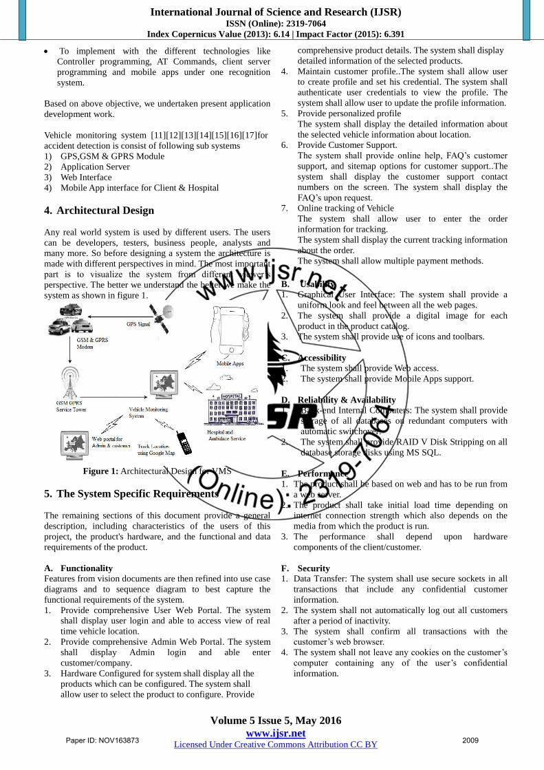
4. Architectural Design
Any real world system is used by different users. The users
can be developers, testers, business people, analysts and
many more. So before designing a system the architecture is
made with different perspectives in mind. The most important
part is to visualize the system from different viewer‟s
perspective. The better we understand the better we make the
system as shown in figure 1.
Figure 1: Architectural Design for VMS
5. The System Specific Requirements
The remaining sections of this document provide a general
description, including characteristics of the users of this
project, the product's hardware, and the functional and data
requirements of the product.
A. Functionality
Features from vision documents are then refined into use case
diagrams and to sequence diagram to best capture the
functional requirements of the system.
1. Provide comprehensive User Web Portal. The system
shall display user login and able to access view of real
time vehicle location.
2. Provide comprehensive Admin Web Portal. The system
shall display Admin login and able enter
customer/company.
3. Hardware Configured for system shall display all the
products which can be configured. The system shall
allow user to select the product to configure. Provide
comprehensive product details. The system shall display
detailed information of the selected products.
4. Maintain customer profile..The system shall allow user
to create profile and set his credential. The system shall
authenticate user credentials to view the profile. The
system shall allow user to update the profile information.
5. Provide personalized profile
The system shall display the detailed information about
the selected vehicle information about location.
6. Provide Customer Support.
The system shall provide online help, FAQ‟s customer
support, and sitemap options for customer support..The
system shall display the customer support contact
numbers on the screen. The system shall display the
FAQ‟s upon request.
7. Online tracking of Vehicle
The system shall allow user to enter the order
information for tracking.
The system shall display the current tracking information
about the order.
The system shall allow multiple payment methods.
B. Usability
1. Graphical User Interface: The system shall provide a
uniform look and feel between all the web pages.
2. The system shall provide a digital image for each
product in the product catalog.
3. The system shall provide use of icons and toolbars.
C. Accessibility
1. The system shall provide Web access.
2. The system shall provide Mobile Apps support.
D. Reliability & Availability
1. Back-end Internal Computers: The system shall provide
storage of all databases on redundant computers with
automatic switchover.
2. The system shall provide RAID V Disk Stripping on all
database storage disks using MS SQL.
E. Performance
1. The product shall be based on web and has to be run from
a web server.
2. The product shall take initial load time depending on
internet connection strength which also depends on the
media from which the product is run.
3. The performance shall depend upon hardware
components of the client/customer.
F. Security
1. Data Transfer: The system shall use secure sockets in all
transactions that include any confidential customer
information.
2. The system shall not automatically log out all customers
after a period of inactivity.
3. The system shall confirm all transactions with the
customer‟s web browser.
4. The system shall not leave any cookies on the customer‟s
computer containing any of the user‟s confidential
information.
Paper ID: NOV163873 2009

International Journal of Science and Research (IJSR) ISSN (Online): 2319-7064
Index Copernicus Value (2013): 6.14 | Impact Factor (2015): 6.391
Volume 5 Issue 5, May 2016
www.ijsr.net Licensed Under Creative Commons Attribution CC BY
G. Data Storage
1. The customer‟s web browser shall never display a
customer‟s password. It shall always be echoed with
special characters representing typed characters.
2. The system‟s back-end servers shall never display a
customer‟s password. The Customer‟s password may be
reset but never shown.
3. The system‟s back-end servers shall only be accessible to
authenticated administrators.
4. The system‟s back-end databases shall be encrypted.
H. Design Constraints
Standard Development Tools: The system shall be built using
a standard web page development tool that conforms to
Microsoft‟s GUI standards.
I. Interfaces
1. There are many types of interfaces as such supported by
the VMS namely, User Interface, Software Interface and
Hardware Interface.
2. The protocol used shall be HTTP.
3. There shall be logical address of the system in IPv4
format.
J. User Interfaces
The user interface for the software shall be compatible to any
browser such as Internet Explorer, Mozilla or Netscape
Navigator by which user can access to the system.
K. Hardware Interfaces
Since the application must run over the internet, all the
hardware shall require to connect internet will be hardware
interface for the system. e.g. GSM, GPRS.
L. Software Interfaces
1. The VMS shall communicate with the content manager
to get the product specifications, offerings and
promotions.
2. The VMS system shall communicate with bill Pay
system to identify available payment methods, validate
the payments and process payment.
3. The VMS system shall deals with critical situation of
Vehicle
4. The VMS shall locate Real Time vehicle location.
6. Context Diagrams
A context diagram is a graphical representation of the "flow"
of data through an information system, modeling its process
aspects. A DFD is often used as a preliminary step to create
an overview of the system, which can later be elaborated
DFDs for designing context which can also be used for the
visualization of data processing (structured design).Figure 2
shows what kind of information will be input to and output
from the system, where the data will come from and go to,
and where the data will be stored.
1 Send Received GPS Signal
2 Send Accident Alert
3 Send Hardware Status
4 Send Stop Info
5 Enroll customer
6 Enroll Vehicle
7 Enroll Hardware/Unit
8 Enroll Supplier
9 Enroll perches info
10 Enroll Sale Info
11 Enroll Product
12 Track Vehicle
13 Manage Vehicle
14 View History
15 Add profile
16 Add Geo Fencing
17 View Report
18 View dashboard & Alert
19 View accident Alert
20 Send Ambulance Availability
21 Send Ambulance after Confirmation
22 Get Accident Massage
23 Get Victim Hospital Admission Massage
Figure 2: Context Diagram
7. Algorithm
1. Accident signal detected.
2. Hardware send signal to server and they are recognized
by unique id and location.
3. Identifies the location of the vehicle.
4. And clustering algorithm provides the information
about nearest hospitals.
5. Server sends MSG about the accident and its location to
programmed numbers.
6. Service call center also get the message on emergency
page and it is operated manually.
7. Nearest hospitals get message on their application and
then pole for ambulance service with registered
ambulance.
8. After ambulance confirmation user/customer can view
Root and Time on Google map for getting help.
8. Implementation
System Implementation is completed with the help of .net
and using IIS server. Systems have admin dash board as
shown in figure 3. Proper authentication should be there to
login the admin portal .Next fields present to login the Admin
portal
After Login the admin portal, dashboard page get opened
having details of number of customers, Number of vehicles.
Paper ID: NOV163873 2010

International Journal of Science and Research (IJSR) ISSN (Online): 2319-7064
Index Copernicus Value (2013): 6.14 | Impact Factor (2015): 6.391
Volume 5 Issue 5, May 2016
www.ijsr.net Licensed Under Creative Commons Attribution CC BY
Admin portal contain following left hand side menu:
Customer registration, Add Vehicle, Add Product, Purchase
form, Sale form, Add unit, Add supplier. On clicking register
Customer, Customer registration forms get open. On clicking
Add vehicle, Add vehicle form get opened .Here Admin able
to add the Vehicles and register it for using the VTS services.
On clicking Add product, Add product form get opened
.Here Admin able to add the Product .On clicking Add unit,
Add unit form get opened .Here Admin able to add the unit
and register it for using the VTS services .On clicking Add
supplier, Add supplier form should get opened .Here Admin
able to add the supplier. On clicking Sale form, sale form get
opened .Here admin able to map unit with customer On
clicking purchase form, Purchase form get opened .Here
admin able to purchase product and map with supplier.
Figure 3: Graphical User Interface for Admin Dash Board
Figure 4: Vehicle Track on Google Map
On clicking track vehicle particular vehicle , all the data of
that particular vehicle displayed along with Google map,
Vehicle No, Track, Location, Google map showing location
of the vehicles as shown in figure 4.
Geo Fencing is an important feature. User have to just enter
the Origin and destination of vehicle then system have to
provide an optimised path for that rout , User could modify
that path according to his need, still we will find best rout out
of it. For this Select vehicle, Enter route, enter date.
Figure 5: Graphical User Interface for Manage Vehicle
As shown in figure 5 of mange vehicle is used for
configuring vehicle and hardware for the system.
9. Observation And Deployment
Automobile theft and accidents in the transportation systems
have caused significant loss of lives, waste of energy, and
loss in productivity. To improve the safety, security and
efficiency of the transportation systems and enable new
mobile services and applications for the traveling public, the
project have been developed, which apply rapidly emerging
information technologies in vehicles and transportation
infrastructures. It is one of the most challenging and critical
issues for the industries. The practical model of this
Dissertation will be very efficient, cheaper, and reliable
system for security & safety.
10. Conclusion
This application detects Accident and generating message
which is informing family members/vehicle owners about the
location of accident. This type of application is used for
transport management system of Smart City Project in India
as well. This application has facility of tracking and Geo-
fencing.We can conclude that the output of this algorithm is
gives better results.
11. Acknowledgement
In this Paper, I would like to acknowledge who have helped
me to complete this paper in presentable manner. But as a
matter of tradition I have tried to express it in my simple
words. I would humbly like to thank my guide Prof. R.B.
Naik for his guidance. Without his help it would not have
been possible to reach at this stage.
References
[1] Flesher P.B. “Design and development of GPS/GSM
based vehicle tracking and alert system for commercial
intercity buses”IEEE,25 Oct 2012,pp 1-6
[2] C.Prabha, R.Sunitha, R.Anitha “Automatic Vehicle
Accident Detection and Messaging System Using GSM
and GPS Modem”- International Journal of Advanced
Research in Electrical, Electronics and Instrumentation
Engineering,Vol1,2010,pp1-5
[3] Pankaj Verma “Design and development of GPS/GSM
based tracking System with Google map based
monitoring”,IJCSEA,Vol no3 ,June 2013,pp33-40
[4] Montaser N. Ramadan - Intelligent Anti-Theft and
Tracking System for Automobiles - International Journal
Paper ID: NOV163873 2011

International Journal of Science and Research (IJSR) ISSN (Online): 2319-7064
Index Copernicus Value (2013): 6.14 | Impact Factor (2015): 6.391
Volume 5 Issue 5, May 2016
www.ijsr.net Licensed Under Creative Commons Attribution CC BY
of Machine Learning and Computing, Vol. 2, No. 1,
February 2012
[5] Pravada P. “Real time Vehicle Locking and tracking
system Using GSM and GPS Technology-an anti theft
system”IJTES,March2011,Vol2, pp 272-275
[6] Kunal Maurya “Real Time Vehicle Tracking System
using GSM andGPS Technology” International Journal
of Electronics and Computer Science Engineering pp
1103-1107
[7] T. Krishna Kishore, T.Sasi Vardhan, N.Lakshmi
Narayana, „Automobile Tracking Using a Reliable
Embedded Data Acquisition Sysytem With GPS and
GSM‟, International Journal of Computer Science and
Network Security, VOL.10 No.2, 2010,pp 286-291
[8] M. A. Al-Taee, O. B. Khader, and N. A. Al-Saber,“
Remote monitoring of Automobile diagnostics and
location using a smart box with Global Positioning
System and General Radio Service,” in Proc. IEEE/ACS
AICCSA, May 13–16, 2007, pp. 385–388
[9] Tamil, E.M., D.B. Saleh, and M.Y.I. Idris, “A Mobile
Automobile Tracking System with GPS/GSM
Technology”, Proceedings of the 5th Student Conference
on Research and Development (SCORED), Permala
Bangi, Malaysia, May 2007.
[10] Fan, X., W. Xu, H. Chen, and L. Liu, “CCSMOMS:A
Composite Communication Scheme for Mobile Object
Management System”, 20th International Conference on
Advanced Information Networking and Applications,
Volume 2, Issue 18-20, April 2006, pp. 235–239
[11] Hsiao, W.C.M., and S.K.J. Chang, “The Optimal
Location Update Strategy of Cellular Network Based
Traffic Information System”, Intelligent Transportation
Systems Conference, 2006.
[12] Ioan Lita, Ion Bogdan Cioc and Daniel Alexandru Visan,
“A New Approach of Automobile Localization System
Using GPS and GSM/GPRS Transmission,” Proc. ISSE '
06, 2006, pp. 115-119.
[13] Wen Leng and Chuntao Shi, “The GPRS-based location
system for the long-distance freight”, ChinaCom '06,
Oct.2006, pp1-5.
[14] Hapsari, A.T., E.Y. Syamsudin, and I. Pramana, “Design
of Automobile Position Tracking System Using Short
Message Services And Its Implementation on FPGA”,
Proceedings of the Conference on Asia South Pacific
Design Automation, Shanghai, China, 2005.
[15] C. E. Lin, C. C. Li, S. H. Yang, S. H. Lin; C. Y. Lin,
“Development of On-Line Diagnostics and Real Time
Early Warning System for Automobiles,” in Proc. IEEE
Sensors for Industry Conference, Houston, 2005, pp. 45-
51
[16] J. E.Marca, C. R. Rindt,M.Mcnally, and S. T. Doherty,
“A GPS enhanced in-Automobile extensible data
collection unit,” Inst. Transp. Studies, Univ.California,
Irvine, CA, Uci-Its- As-Wp-00-9,2000,pp.522-525.
[17] Mohammad A. Al-Khedher “Hybrid GPS-GSM
Localization of Automobile Tracking
system”International Journal of Computer Science &
Information Technology (IJCSIT) Vol 3, No 6, Dec
2000,pp. 321-328.
Paper ID: NOV163873 2012