Vegetation and climate of north anatolian and north … d’ordre : 298 - 2010 Année 2010 THESE en...
144
HAL Id: tel-00720892 https://tel.archives-ouvertes.fr/tel-00720892 Submitted on 26 Jul 2012 HAL is a multi-disciplinary open access archive for the deposit and dissemination of sci- entific research documents, whether they are pub- lished or not. The documents may come from teaching and research institutions in France or abroad, or from public or private research centers. L’archive ouverte pluridisciplinaire HAL, est destinée au dépôt et à la diffusion de documents scientifiques de niveau recherche, publiés ou non, émanant des établissements d’enseignement et de recherche français ou étrangers, des laboratoires publics ou privés. Vegetation and climate of north anatolian and north aegean region since 7 Ma according to pollen analysis Demet Biltekin To cite this version: Demet Biltekin. Vegetation and climate of north anatolian and north aegean region since 7 Ma according to pollen analysis. Earth Sciences. Université Claude Bernard - Lyon I, 2010. English. <NNT : 2010LYO10298>. <tel-00720892>
-
Upload
phamnguyet -
Category
Documents
-
view
215 -
download
2
Transcript of Vegetation and climate of north anatolian and north … d’ordre : 298 - 2010 Année 2010 THESE en...

HAL Id: tel-00720892https://tel.archives-ouvertes.fr/tel-00720892
Submitted on 26 Jul 2012
HAL is a multi-disciplinary open accessarchive for the deposit and dissemination of sci-entific research documents, whether they are pub-lished or not. The documents may come fromteaching and research institutions in France orabroad, or from public or private research centers.
L’archive ouverte pluridisciplinaire HAL, estdestinée au dépôt et à la diffusion de documentsscientifiques de niveau recherche, publiés ou non,émanant des établissements d’enseignement et derecherche français ou étrangers, des laboratoirespublics ou privés.
Vegetation and climate of north anatolian and northaegean region since 7 Ma according to pollen analysis
Demet Biltekin
To cite this version:Demet Biltekin. Vegetation and climate of north anatolian and north aegean region since 7 Maaccording to pollen analysis. Earth Sciences. Université Claude Bernard - Lyon I, 2010. English.<NNT : 2010LYO10298>. <tel-00720892>
N° d’ordre : 298 - 2010 Année 2010
THESE
en cotutelle
présentée
devant l’UNIVERSITE CLAUDE BERNARD – LYON 1
et l’UNIVERSITE TECHNIQUE D’ISTANBUL
pour l’obtention
du DIPLOME DE DOCTORAT
(arrêté du 7 Août 2006)
présentée et soutenue publiquement à Istanbul le 21 Décembre 2010 par
Demet BİLTEKİN
Vegetation and climate of North Anatolian and North Aegean region since 7 Ma according to pollen analysis
Directeurs de thése: Jean-Pierre SUC Namık ÇAĞATAY
Jury : Namık ÇAĞATAY, Professeur, Université Technique d’İstanbul, Directeur de thése Speranta-Maria POPESCU, Chercheur, Institut de Physique du Globe de Paris, Examinateur Mehmet SAKINÇ, Professeur, Université Technique d’İstanbul, Examinateur Jean-Pierre SUC, Directeur de Recherche émérite du CNRS, Directeur de thése Frédéric THEVENARD, Professeur, Université C. Bernard-Lyon1, Examinateur Namık YALÇIN, Professeur, Université d’İstanbul, Rapporteur Rapporteurs absents : Dimiter IVANOV, Chercheur, Académie des Sciences de Bulgarie, Rapporteur Paul ROIRON, Maître de Conférence, Université Montpellier II, Rapporteur

ABSTRACT Anatolia is an area inhabited today by relict thermophilous plants: Liquidambar orientalis, Parrotia
persica, Pterocarya fraxinifolia, Zelkova crenata (Angiosperms) and Cedrus (Gymnosperm). These
trees constitute forests relatively close to Artemisia steppes, being the two types of vegetation in
competition during the climatic cycles along the last 2.6 million years. Thus, this makes the greatest interest for palynological investigations in the region. This study concerns a long marine section
(DSDP Site 380 from the southwestern deep Black Sea: Late Miocene to Present) and onshore
exposed sections (marine and lacustrine sediments) from the Late Miocene and/or Early Pliocene. The
study area corresponds to the surroundings of the Marmara Sea (Enez, İntepe, Eceabat, Burhanlı, West Seddülbahir), southwestern Black Sea (DSDP Site 380), and northern Greece (Ptolemais Notio, Ptolemais Base, Prosilio, Trilophos and Lion of Amphipoli). The main target of this study is to
reconstruct vegetation and climate during this time-interval in the region. The high-resolution pollen
analysis of the 1,073.50 m long Black Sea Site 380 (to which I directly contributed for the interval 702.40 – 319.03 m) documents in great detail the evolution of vegetation and climate from the Late
Miocene up to Present. Two vegetation types were alternately dominant for the last 7 million years: thermophilous forests and open vegetations including Artemisia steppes. At the early Messinian
(before the Messinian Salinity Crisis), herbs prevailed in the Dardanelles area while mid- (Tsuga) and
high-altitude (Abies and Picea) conifers were abundant with Cupressaceae close to the Olympe Mount (Prosilio). After the Messinian Salinity Crisis, North Aegean vegetation was mainly characterized by
open plant ecosystems nearby forest assemblages with mesothermic trees (deciduous Quercus, Carya, Zelkova, etc.). In addition, strengthening of altitudinal conifers (Cedrus, Tsuga, Abies and Picea) may
signify some uplift of the regional massifs. During the Late Miocene, most of the megathermic
(tropical) and mega-mesothermic (subtropical) plants declined because of the climatic deterioration. However, some of them survived during the Late Pliocene, such as those which constituted coastal swamp forests (Glyptostrobus, Engelhardia, Sapotaceae, Nyssa) or composed deciduous mixed forests with mesothermic trees. Simultaneously, herbaceous assemblages (with Amaranthaceae-Chenopodiaceae, Poaceae, Asteraceae Asteroideae, Asteraceae Cichorioideae, etc.) became a
prevalent vegetation component despite steppe elements (Artemisia, Ephedra, Hippophae
rhamnoides) did not significantly develop. This suggests cooler and chiefly drier conditions during the Late Pliocene. At the Early Pleistocene (2.6 Ma), as a response to the onset of Arctic glaciations, megamesothermic elements rarefied despite some taxa persisted (Taxodiaceae: probably Glyptostrobus, Engelhardia, Sapotaceae, and Nyssa). In parallel, deciduous mixed forest assemblages composed of mesothermic trees (deciduous Quercus, Betula, Alnus, Liquidambar, Fagus, Carpinus
orientalis, Carpinus betulus, Tilia, Acer, Ulmus, Zelkova, Carya, Pterocarya, etc.) almost disappeared too while steppe environments strongly enlarged. Then, Artemisia steppic phases developed during longer temporal intervals than mesophilous tree phases all along the glacial-interglacial cycles (first with a period of 41 kyrs, then 100 kyrs). This suggests shorter interglacials (warm and humid climate) than glacials (cool to cold and dry climate). From the beginning of the Ioanian Stage (1.8 Ma), herbaceous ecosystems (with Amaranthaceae-Chenopodiaceae, Poaceae, Asteraceae Asteroideae, Asteraceae Cichorioideae, etc.) and Artemisia steppes still continuously enlarged up today. Such an expansion of Artemisia steppes in the Ponto-Euxinian region was observed at the earliest Pliocene (DSDP Site 380) but their earliest settlement in Anatolia seems to have occurred in the Early Miocene (Aquitanian). The development of the Artemisia steppes in Anatolia might result from the uplift of the Tibetan Plateau. At last, relictuous plants such as Carya, Carpinus orientalis, Pterocarya, Liquidambar orientalis, Zelkova persisted up today for most of them. This story can be explained by some influence of the Asian monsoon which reinforced as a result from the uplifted Tibetan Plateau.

RESUME L'Anatolie est un secteur aujourd'hui habité par des plantes thermophiles en situation de refuges. Sont concernées des Angiospermes (Liquidambar orientalis, Parrotia persica, Pterocarya fraxinifolia, Zelkova crenata) et une Gymnosperme (Cedrus), arbres de forêts contrastant avec la steppe à Artemisia, les deux types de végétation en forte compétition pendant les cycles climatiques des 2,6 derniers millions d'années. Ainsi, ceci confère-t-il le plus grand intérêt aux investigations palynologiques dans la région. Cette étude concerne un long enregistrement sédimentaire marin (Site profond DSDP 380 en Mer Noire sudoccidentale) et des affleurements à terre de dépôts marins ou lacustres du Miocène supérieur et(ou) du Pliocène inférieur. Le secteur étudié à terre porte sur les environs de la Mer de Marmara (Enez, Eceabat, Seddülbahir) et la Grèce septentrionale (Ptolemais Notio et Ptolemais Base, Prosilio, Trilophos et Lion d'Amphipoli). L’objectif principal de cette recherche est de reconstruire la végétation et le climat régionaux pendant ces intervalles de temps. L'enregistrement pollinique à haute résolution des 1.073,50 m du Site 380 (auquel j’ai contribué de façon significative à travers l’intervalle 702,4 – 319 m) documente en détail l’évolution de la végétation et du climat de la fin du Miocène à l’Actuel. Deux types de végétation y furent alternativement dominants au cours des 7 derniers millions d'années : les forêts de plantes thermophiles et les steppes à Artemisia. Au début du Messinien (avant la Crise de salinité messinienne), les herbes étaient dominantes dans la région des Dardanelles tandis que les conifères de moyenne (Tsuga) et haute altitude (Abies et Picea) abondaient avec les Cupressaceae près du Mont Olympe (Prosilio). Dans cette même région nord-égéenne, la végétation était après la Crise de salinité messinienne caractérisée principalement par des formations ouvertes à côté de groupements forestiers à arbres mésothermes (Quercus décidus, Carya, Zelkova, etc.). Par ailleurs, l’expansion des conifères altitudinaux (Cedrus, Tsuga, Abies et Picea) y est documentée et semble traduire un soulèvement des massifs environnants. A la fin du Miocène, la plupart des éléments mégathermes (tropicaux) et méga-mésothermies (subtropicaux) avaient régressé en raison des détériorations climatiques. Cependant, certains d'entre eux ont survécu pendant le Pliocène supérieur, notamment ceux qui constituaient des forêts littorales marécageuses (Glyptostrobus, Engelhardia, Sapotaceae, Nyssa) ou participaient à des forêts mixtes avec des arbres décidus mésothermes. Pendant ce temps, les formations ouvertes à herbes (Amaranthaceae-Chenopodiaceae, Poaceae, Asteraceae Asteroideae, Asteraceae Cichorioideae, etc.) sont devenues prédominantes dans la végétation sans que les éléments steppiques (Artemisia, Ephedra, Hippophae rhamnoides) soient très abondants. Ceci suggère un refroidissement au Pliocène supérieur et surtout l’installation de conditions plus sèches. Au début du Pléistocène (2,6 Ma), sous l’effet des premières glaciations arctiques, les éléments méga-mesothermes se sont très raréfiés malgré la persistance de quelques reliques (Taxodiaceae : probablement Glyptostrobus, Engelhardia, Sapotaceae, Nyssa). Simultanément, les forêts mixtes à éléments mésothermes (Quercus décidus, Betula, Alnus, Liquidambar, Fagus, Carpinus orientalis, Carpinus betulus, Tilia, Acer, Ulmus, Zelkova, Carya, Pterocarya, etc) ont aussi quasiment disparu tandis que les environnements steppiques se développaient fortement. Désormais, tout au long des cycles glaciaire-interglaciaire (d’abord de 41 ka de périodicité puis de 100 ka), les steppes à Artemisia occuperont plus d’espace temporel que les phases arborées. Ceci suggère des interglaciaires (chauds et humides) plus courts que les glaciaires (frais à froids et secs). Depuis le début de l'étage Ionien (1,8 Ma), les environnements à herbes (Amaranthaceae-Chenopodiaceae, Poaceae, Asteraceae Asteroideae, Asteraceae Cichorioideae, etc.) et les steppes à Artemisia n’ont cessé de s’étendre jusqu' à aujourd'hui. Cette expansion des steppes à Artemisia dans la région du Pont-Euxin a été observée au tout début du Pliocène (Site DSDP 380) mais leur premier enregistrement en Anatolie date de l’Aquitanien (Miocène inférieur). Le développement de la steppe à Artemisia en Anatolie pourrait résulter du soulèvement du Plateau tibétain. Enfin le maintien dans cette région de plantes thermophiles reliques en situation de refuges (Carya, Carpinus orientalis, Pterocarya, Liquidambar orientalis, Zelkova), dont certaines jusqu’à nos jours, peut être expliqué par l’influence grandissante de la mousson asiatique dont le renforcement aurait aussi résulté du soulèvement du Plateau tibétain.

ACKNOWLEDGEMENTS
This PhD thesis study is the French-Turkish (Co-tutelle de thèse) enabled me chance for studying between the University of Claude Bernard-Lyon1 and the Istanbul Technical University. I would like to thank all people helped me during my PhD thesis study.
Firstly, I would like to thank my thesis directors: Prof. Dr. Jean-Pierre SUC (University of Claude Bernard-Lyon 1) and Prof. Dr. Namık ÇAĞATAY (Istanbul Technical University). They were of great help. Warm thanks to Prof. Dr. Jean-Pierre SUC who supported me in Palynology, thanks to him for his great experience on pollen grain taxonomy, on identifiying pollen grains and for his endless patience during my thesis. He encouraged and helped me everytime during my stay in the University of Claude Bernard-Lyon 1. I also would like to thank to him for his efforts, advices and guidance during my thesis study. Warm thanks to Prof. Dr. Namık ÇAĞATAY who gave me opportunity to study Palynology and He introduced me to Prof. Dr. Jean-Pierre SUC. He always encouraged and helped me during my PhD thesis. I also would like to thank for his precious advices, his enthusiasm and his support during my thesis.
Many thanks to the members of my Comittee of Pilotage in the University of Claude Bernard-Lyon1: Speranta-Maria POPESCU, Marc PHILIPPE, Serge LEGENDRE and Gilles ESCARGUEL for their advices and collaboration.
Many thanks to member of my thesis Comittee in Istanbul Technical University: Prof. Dr. Naci GÖRÜR, Prof. Dr. Mehmet SAKINÇ, Prof. Dr. Ercan ÖZCAN and Prof. Dr. Namık YALÇIN of Istanbul University for their advices and contribution.
I would like to thank Dr. Speranta-Maria POPESCU for her helping and advising during my thesis and staying in the University of Claude Bernard-Lyon1.
I am very grateful towards the members of the Examination Board of my thesis who accepted to report on my manuscript (Prof. Dimiter IVANOV from Sofia, Prof. Paul ROIRON from Montpellier and Prof. Namık YALÇIN from Istanbul) and/or to discuss it at my oral defense (Prof. Frédéric THEVENARD, Dr. Speranta-Maria POPESCU, Prof. Naci GÖRÜR, Prof. Ercan ÖZCAN, Prof. Mehmet SAKINÇ and Prof. Namık YALÇIN).
Thanks to the technical support in the Laboratory PEPS of the University C. Bernard – Lyon 1 and thanks to the French Embassy by the financial support obtained (thesis in cotutelle) in Lyon.
Thanks to TÜBİTAK and EMCOL (Eastern Mediterranean Oceanography Center) for financal support in İstanbul during my PhD thesis.
Many thanks to Lysiane THENEVOD, Mathieu DALİBARD, Anissa SAFRA, and Simona BOROI, I shared with them microcope work in the loboratory and also thanks to Philippe SORREL, Eric FAVRE, Sébastien JOANNIN, Florent DALESME and Gwénael JOUANNIC for all their friendship.
Many thanks to EMCOL staff: Ümmühan SANCAR, Umut Barış ÜLGEN, Emre DAMCI, Sena AKÇER ÖN, Dursun ACAR, Zeynep ERDEM and Ayşe KAPLAN for all their friendship during my PhD thesis.
Finally, I thank my family, they supported me through my education life. Especially my mother, she always believed in me and encouraged me to begin my PhD studies and supported every step in my thesis study.

TABLE OF CONTENTS
1. INTRODUCTION.................................................................................................. 1
1.1 Aims of the Study............................................................................................... 8
2. PHYSIOGRAPHY, STRATIGRAPHY AND PALEOGEOGRAPHY OF THE STUDY AREAS ......................................................................................................... 9
2.1 Turkey ................................................................................................................ 9
2.1.1 Present-day vegetation ................................................................................ 9
2.1.2 Climate ...................................................................................................... 13 2.1.2.1 Turkey ............................................................................................ 13
2.1.2.2 Greece and Macedonia ................................................................... 16 2.1.3 Stratigraphy of the study areas .................................................................. 19
2.1.4 Paleogeography ......................................................................................... 23
3. METHOD ............................................................................................................. 31
3.1 Sampling and Chemical Processing ................................................................. 32
3.2 Identification of Pollen Grains ......................................................................... 33
4. CHRONOLOGY OF THE STUDIED SECTIONS .......................................... 41
5. RESULTS ............................................................................................................. 45
5.1 DSDP Site 380 ................................................................................................. 45
5.1.1 Lithology ................................................................................................... 45
5.1.2 High-resolution pollen record of DSDP 380 ............................................ 51
5.2 Gulf of Saros .................................................................................................... 58
5.2.1 Enez .......................................................................................................... 58
5.3 Dardanelles Strait ............................................................................................. 61
5.3.1 İntepe ........................................................................................................ 61
5.3.2 West of Seddülbahir .................................................................................. 65
5.3.3 Eceabat ...................................................................................................... 67
5.3.4 Burhanlı .................................................................................................... 68
5.4 Western Macedonia .......................................................................................... 69
5.4.1 Ptolemais notio ......................................................................................... 69
5.4.2 Ptolemais base ........................................................................................... 71
5.5 Northern Greece ............................................................................................... 75
5.5.1 Trilophos ................................................................................................... 75
5.5.2 Prosilio ...................................................................................................... 76
5.5.3 Lion of Amphipoli .................................................................................... 78
6. DISCUSSION ....................................................................................................... 81
6.1 Flora and Floristic Refuges .............................................................................. 81
6.2 Vegetation ........................................................................................................ 89
6.2.1 The development of Artemisia steppes ..................................................... 95
6.3 Climate ............................................................................................................. 99
6.3.1 Global climate context during the Miocene and Pliocene ........................ 99
6.3.2 Climatic evolution of the studied areas ................................................... 102
7. CONCLUSIONS ................................................................................................ 107
REFERENCES ....................................................................................................... 111

ABBREVIATIONS
MSC : Messinian Salinity Crisis NAF : North Anatolian Fault Ma : Million years cP : Continental Polar Air Mass mP : Marine Polar Air Mass cT : Continental Tropical Air Mass mT : Marine Tropical Air Mass PJF : Polar Front Jet STJ : Subtropical Jet ITCZ : Intertropical Convergence Zone

1
1. INTRODUCTION
Present flora and vegetation of the North Aegean region and Anatolia show peculiar
characteristics that find their origin in the past (Zohary, 1973; Quézel and Médail,
2003). In fact, this area counts today a lot of relictous plants (such as Platanus
orientalis, Liquidambar orientalis, Pterocarya fraxinifolia, Zelkova crenata,
Cedrus libani) inhabiting separated places within more or less thermophilous
residual forests (Fig. 1a, 1b). In addition, vegetation shows high contrasts between
forest (Pontus Euxinus forests, mid- to high-altitude forests) and open landscapes
(mediterranean assemblages, pre-steppic to steppic ecosystems). This plant
assemblage constitutes the alone current testimony of the flora and primary
vegetation which inhabited the Northern Mediterranean region during the last
millions years. The geographical situation of the studied area makes the greatest
interest of this region for palynological studies. Pollen analyses developed on a
botanical backround are very rare in Turkey if it is almost inexisting. There are some
studies on Miocene and Pliocene in Anatolia (Nakoman, 1967; Benda, 1971; Akgün
and Akyol, 1999), but (1) their very poor botanical interest because of a very limited
pollen morphological approach, and (2) the highly questionable quantitative
information that they are supposed to provide make them almost completely
unusable. This study is the first investigation to have been developed in the region on
a fine pollen morphology investigation resulting in reliable botanical comprehensive
information. Pollen identification was performed after their accurate morphology
examination by comparing Neogene pollen grains with their living relatives using
databanks of modern pollen grains and modern-past pollen grains photographs
(atlasses, databases) with respected to botanical nomenclature. At present, the history
of the flora, vegetation and climate of the Mediterranean region are very well-
documented for the last 23 Myrs after the thesis of Jean-Pierre Suc (1980) and the
about twenty theses that he supervised (e.g.: Bessedik, 1985; Zheng, 1986;
Combourieu-Nebout, 1987; Drivaliari, 1993; Fauquette, 1998; Bachiri Taoufiq,
2000; Popescu, 2001; Jiménez-Moreno, 2005; Joannin, 2007; Favre, 2007).

2
Figure 1A : Distribution of Liquidambar, Pterocarya and Zelkova.

3
Figure 1B : Distribution of Cedrus libani.

4
Suc, J-P. (1980) studied different areas from the North-western Mediterranean
region. He demonstrated that the modern Mediterranean vegetation took root in the
Late Pliocene1. Two important events occurred at 3.4 and 2.6 Ma. The former was
the establishment of the modern Mediterranean vegetation and the latter the first
evidence of the vegetation response in the Mediterranean region to the earliest glacial
in the Northern Hemisphere. The previous vegetation was impacted by glacial-
interglacial fluctuations and finally, by human activity.
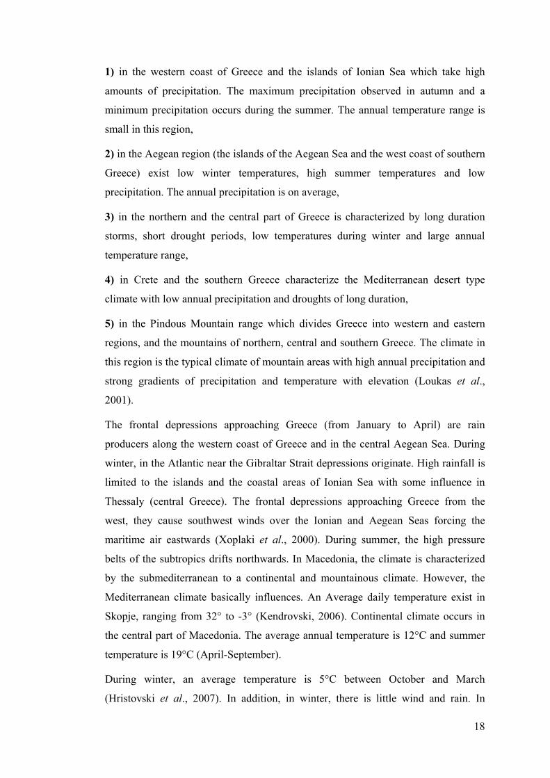
Jiménez-Moreno, G. (2005) documented Early to Late Miocene vegetation and
climate dynamics from the South-eastern Europe to the North-eastern Mediterranean.
There was a progressive rarefaction of the most thermophilous trees and shortening
of the broad-leaved evergreen forest. On the contrary, there were a development in
mesothermic (mainly deciduous) elements, altitudinal trees and herbs during the
Middle and Late Miocene. This can be related to enlargement of the East Antartic Ice
Sheet (EAIS) and regional uplift.
Popescu, S. (2001) carried out high resolution pollen analysis on the Lupoaia section
(SW Romania). Pollen records enabled the reconstruction of the early Pliocene
vegetation of southwestern Romania. Repeated changes in vegetation occurred with
clay-lignites alternation. While altitudinal trees corresponded a decrease in
temperature, thermophilous trees developed under humid conditions.
Popescu et al., (2006) studied pollen records of the western Dacic Basin. The Early
Zanclean sediments of Dacic Basin was provided by pollen records and eccentricity
curve. According to this, thermophilous plants increased during the lowest
eccentricity minima (in 400 kyrs cycles). On the contrary, altitudinal elements are
enriched during the highest eccentricity maxima.
Popescu, S. (2006) studied to investigate paleovegetation during the Late Miocene-
Early Pliocene from high-resolution pollen analysis in DSDP Site 380. According to
this study, the Late Miocene vegetation was characterized by delta environment.
During Early Pliocene, two vegetation types were defined by thermophilous plants
and dry steppes.
1 Here, we follow the chronostratigraphic nomenclature recently adopted by IUGS (Gibbard et al., 2009) where Pliocene is constituted by two stages, Zanclean (5.332 – 3.6 Ma) and Piacenzian (3.6 – 2.588 Ma), Gelasian becoming the first stage of Pleistocene (i.e. Quaternary).

5
In order to be sure to well appreciate the contrast between forest and steppe
vegetation, the investigated region has been defined a little larger than the Anatolia
region and includes also the surroundings of the Marmara Sea, a part of the
southwestern Black Sea shorelines and of northern Greece (Fig. 1.2).
The region was subject to intense paleogeographic changes controlled by regional
tectonics extremely active since 6 Ma and by the partly coexisting desiccation of the
Mediterranean and Black seas (5.6-5.33 Ma) (Armijo et al., 1999; Görür et al., 1997,
2000; Gillet, 2004; Clauzon et al., 2005; Melinte et al., 2009). The North Anatolian
Fault (NAF) extends from Karlıova to the Gulf of Saros along the Black Sea
mountains of North Anatolia (Fig. 1.3). It seems to have originated during the Late-
Middle Miocene when the Anatolian plate separated. The westward motion of the
Anatolia plate with respect to Eurasia and African plates induced great geodynamic
changes in the Eastern Mediterranean. This gave rise to the Aegean extensional
regime and deformation of Anatolia (Şengör, 1979).
Today, relictous plants are distributed in the eastern Mediterranean region. Such an
evolution was forced by the successive coolings in the Antarctic area first (at 14 Ma
then 5.8 Ma), then especially the repeated Arctic coolings (since 3.6 Ma) that
controlled the glacial-interglacial cycles since 2.6 Ma. Simultaneously, the
environments in the South Mediterranean, already characterized by open vegetations
since the earliest Miocene (probably because of the neighborhood of the pre-existing
Sahara Desert), were enriched in Artemisia steppe element probably originating from
the Anatolian Plateau (Artemisia) (Popescu, 2006) that repeatedly invaded the entire
Mediterranean realm at each Arctic glaciation. Some testimonies of these relictuous
floras and thermophilous vegetations exist both to the West (mountains of South
Morocco, Canary Islands) and to the East (Anatolia, southern Caucasus) (Quézel and
Médail, 2003).

6
Figure 1.2 : Map showing the studied pollen localities (black dots).

7
Figure 1.3 : Map showing the main tectonic elements of eastern Mediterranean regions (modified from McKenzie, 1972; Şengör et al., 1985; Okay et al., 1999).

8
1.1 Aims of the Study
Anatolia is one of the most important refuge area. The geographic position of Turkey
also makes concerned area significant for palynological investigations. There are
some pollen studies both Miocene and Pliocene in Turkey. However, they have lack
of accurate botanical identification and therefore they are questionable. Hence, this
thesis work is the first study based on the pollen botanical nomenclature which
improve significantly floristic and vegetation interpretations. In this study, 436
samples from both marine (in the western Black Sea, DSDP Site 380) and outcrops
sediments in the NW Turkey (Enez, İntepe, Eceabat, Burhanlı and West
Seddülbahir), Northern Greece (Prosilio, Trilophos and Lion of Amphipoli) and
Western Macedonia (Ptolemais Notio and Ptolemais Base) which covers time-
intervals between the Late Miocene-Early Pleistocene are analysed palynologicaly.
On the whole, samples are rich in terms of pollen grains. Some samples are barren in
pollen grains. Because of this, these samples are not taken into account in the
synthetic and detailed pollen diagrams. The targets of this thesis using the pollen
analysis of sediments, their identification being botanically driven are:
(1) to document the history of the flora and vegetation of Anatolia, then to compare
with the Western Mediteranean region which is already well-known,
(2) the reconstruction of the vegetation through the studied time-window using
pollen records,
(3) to follow-up on the tropical and subtropical thermophilous plants (distribution,
abundance, etc.) during the Late Cenozoic,
(4) to determine global climatic changes (coolings, warmings, glacial-interglacial
cycles),
(5) to assess the role possibly played by the Asian monsoon effect in the persistence
of floral refuges in the studied regions, and
(6) to determine the relative influence of regional geodynamics.

9
2. PHYSIOGRAPHY, STRATIGRAPHY AND PALEOGEOGRAPHY OF
THE STUDY AREAS
2.1 Turkey
2.1.1 Present-day vegetation
In spite of its diversity and complexity, the present-day vegetation of Anatolia may
be summarized as follows, relating both to the Mediterranean, Irano-Touranian,
European and Euxino-Hyrcanian phytogeographic regions (Fig. 2.1). On the whole,
the Mediterranean realm concerns the West and South coastal areas, with a variable
width (100 to 300 km), but it sporadically appears along the North shoreline and also
in some encased valleys within the Pontic Ranges. It is mainly controlled by climate
(Akman & Ketenoglu, 1986). Several bioclimates and altitudinal vegetation belts
have been defined according to rainfall and altitude (Quézel & Médail, 2003). The
thermo-Mediterranean belt is constituted by assemblages with Olea europea and
Pistacia lentiscus where Ceratonia is scarce, and also by coniferous forests with
Pinus brutia occupying large areas. Some riparian forests are noteworthy, as they
show Alnus associated with Liquidambar orientalis and Platanus orientalis.
Basically, the meso-Mediterranean belt should be characterized by sclerophyllous
oaks, but Quercus ilex is actually very rare being only present from Samsun to
Trabzon. Quercus calliprinos is obviously the most frequent sclerophyllous oak
while Q. aucheri is recorded along the Lycian shoreline. Here, deciduous oaks
(Quercus cerris, Q. trojana, Q. ithaburensis, etc.) have been almost everywhere
replaced by cultivations. On contrary, Pinus brutia occupies an important place
which is not yet completely understood (Boydak, 2006). The supra-Mediterranean
belt is theorically inhabited by deciduous associations. This is right in the northern
region where Quercus pubescens, Q. cerris, Q. petraea subsp. iberica take up a
significant place, often with Carpinus orientalis and Ostrya carpinifolia.
Contrarily, westward and southward, as also on the Amanos Mountains, this
vegetation belt is practically invaded by Pinus brutia, whereas deciduous trees are

10
very scarce and restricted to residual localities. Pinus nigra subsp. pallasiana already
appears in its uppermost part. The Mediterranean montane belt is actually the
altitudinal coniferous belt with abundant specimens of Pinus pallasiana and also
Cedrus libani occupying significant areas on the Taurus and Anti-Taurus massifs, in
association with Abies cilicica westward Antalya in spite of distinct ecological
requirements. These forests, generally very deteriorated, are often replaced by pre-
steppic associations with arborescent Juniperus (J. excelsa, J. foetidissima). The oro-
Mediterranean belt (Quézel, 1973) is invaded by meadows and steppes where prickly
cushion-shaped xerophytes are abundant, a belt already influenced by the Irano-
Touranian conditions. The Irano-Touranian phytogeographic region encompasses the
Anatolian Plateau, mostly eastward the Centro-Anatolian Ridge, and westward areas
characterized by annual precipitations lower than 200 mm. Man greatly disturbed
this region because of repeated attempts in development since antiquity (Akman &
Quézel, 1996). The area is occupied by a very rich steppe vegetation where Artemisia
is relatively subsidiary, at least to the West. Pre-steppic structures with trees appear
only over reliefs where precipitations are higher and man activity less apparent.
Quercus pubescens subsp. anatolica is widely present, very often in a state of grazed
shoots in the northwestern part of the region. Westward, Pinus pallasiana and
Juniperus excelsa are prevalent while Irano-Touranian oaks (Q. libani, Q. brantii, Q.
infectoria subsp. boissieri) grow to the East.
The European phytogeographic region is secondary in Anatolia. Only some
deciduous hilly structures with Quercus and Carpinus betulus may belong to it.
Some other European associations are more obvious within the montane vegetation
belt, from the Kaz Mount to the area of Kastamonu, where beautiful forests develop
including Fagus orientalis (often difficult to distinguish from F. sylvatica) and firs
(Abies equi-troyani, A. bornmuelleriana).
The Euxino-Hyrcanian phytogeographic region, characterized by high precipitations
and the lack of any summer drought, develops all along the Black Sea shoreline.
Here, wonderful hilly forests still exist, dominated by deciduous elements (Quercus
hartwissiana, Q. macranthera, Carpinus betulus, Castanea sativa, with Fagus
orientalis and Rhododendron ponticum in some places, even Rh. flavum).
Some alluvial associations and riparian forests show Alnus, Fraxinus, and
Pterocarya in some localities (see below).

11
The montane belt is mainly occupied by Fagus orientalis and Rhododendron
ponticum, with locally Abies nordmannian, and Eastward Picea orientalis. Pinus
sylvestris is present from place to place in marginal areas, especially to the South.
The subalpine and alpine belts are mainly developed to the East where Caucasus
influences infer within a very diversified flora (Juniperus communis and J. sabina
coexist with several Ericaceae). Buxus sempervirens (colchica), often associed with
Taxus baccata, abound on the rare calcareous spaces in the region. Back to the
Euxinian zone, a transition area has been identified between the Mediterranean and
Irano-Touranian phytogeographic regions, the so-called Pre-Pontic region (Quézel et
al., 1980), the vegetation of which is dominated by Abies spp., Pinus nigra subsp.
pallasiana, and P. sylvestris.
May Anatolia be considered as a present-day refuge area of a thermophilous flora?
Some warm-temperate Eurasian taxa (such as Liquidambar, Pterocarya, Cedrus)
have already emerged from this brief overview of the Anatolian vegetation (Quézel,
1995), currently recorded in the European Late Cenozoic pollen records as it will be
emphasized below. According also to Browicz (1982-1994), few taxa are still present
in Anatolia (Liquidambar, Pterocarya, Zelkova) and in the Hyrcanian zone
(Parrotia). Zelkova crenata is today recorded only in two very restricted riparian
localities in easternmost Anatolia close to the Van Lake, although it is still well-
developed in Abkhazia, Small Caucasus, and mainly in the Hyrcanian region. In
addition, this genus is still present in residual stations of Crete (Z. abelicea) and
Sicily (Z. sicula) (Quézel, 1995).
Liquidambar orientalis is concentrated in some more or less important areas (Fig.
2.1): the vastest of which concerns the alluvial and riparian forests of the
southwesternmost part of Anatolia (mainly the area of Köyceğiz – Marmaris),
another one of significantly less extent locates northeastward Antalya (Köseler area;
Akman et al., 1993), the third one along the Oronte River close to Hatay is today
questionable because it seems that it was not recently re-visited. The strong reducing
of the two last localities is attested by ancient documents indicating that Liquidambar
was abundant during the Hellenic time and intensely used for producing styrax
(Amigues, 2007).

12
Figure 2.1 : The present-day vegetation map of Turkey and Greece (Quézel and Barbero, 1985).

13
Pterocarya is still present in alluvial forests along the Black and Marmara seas,
being relatively abundant in the latter (Fig. 2.1). It is also recorded in some localities
near the Iskenderun Gulf where precise information is missing (Fig. 2.1). However,
the tree is frequent out of Anatolia in the above-mentioned regions where Zelkova is
living. Cedrus benefits from better conditions (Quézel and Médail, 2003): it abounds
on the Taurus and Anti-Taurus massifs, although it is declining. Few reduced
localities persist on the back slope of the Pontic Ranges (Erbaa region; Fig. 4), the
indigenous status of which is supported by pollen data (Bottema, 1986). Some other
plants should be added to the above discussed Anatolian relicts, such as Diospyros
lotus, Ilex colchica, Rhododendron spp., even Quercus pontica and Osmanthus
decorus which grows today along the Black Sea shoreline (Quézel, 1986). Anatolia
can undoubtedly be considered as a present-day refuge area of warm-temperate
plants, however with less importance than the Hyrcanian region. Present-day
vegetation of Greece is divided into different vegetation types (Fig. 2.1). They are:
1) Thermo-Mediterranean belt,
2) Meso-Mediterranean belt,
3) Supra-Mediterranean belt,
4) Montane Mediterranean belt,
5) Oro-Mediterranean belt,
6) Montane belt,
2.1.2 Climate
2.1.2.1 Turkey
The location and geographical characteristics of Turkey give a variety of climates,
landscapes and plant diversity. Turkey is located in large Mediterranean geographical
area. The climate is characterized by Mediterranean macro climate. Eastern
Mediterranean region is influenced by three main atmospheric systems (Fig. 2.2): the
main middle to high latitude westerlies to the north and northwest, the mid-latitude
subtropical high-pressure systems extending from the Atlantic across the Sahara and
the monsoon climates of Indian subcontinent and East Africa (Akcar and Schlüchter,
2005).

14
Marine tropical air masses (mT) bring hot and humid air from the tropical north
Atlantic. Continental tropical airstreams (cT) convey from the northern African and
Arabian deserts. It passes over the Mediterranean Sea, and they can obtain moisture
and then condensate over the southern coasts of Anatolia. Marine polar air masses
(mP) carry the humid and cold air from the polar north Atlantic. They have
significant influence when they progress over the Mediterranean Sea. Continental
polar air masses (cT) bring the dry and cold air from Siberia. They can acquire
moisture and condensate on the northern coasts of Turkey (over the Black Sea) (Fig.
2.2). The climatic conditions are warm-temperate in Turkey (Erinç, 1959). It is now
usually known that the climate variability in the middle- and high-latitude continental
Northern Hemisphere mainly controlled by the Arctic Oscillation and North Atlantic
Oscillation (AO/NAO) at interannual and interdecadal timescales (Thompson and
Wallace, 2001). This changing patterns also affect the climate of Turkey and its
surrounding fields (Cullen and deMenocal, 2000; Karaca et al., 2000; Türkeş and
Erlat, 2003; Karabörk et al., 2005; Kahya and Cengiz, 2007). The secondary
cyclogenesis in eastern Mediterranean enables a physical linkage between the NAO
(known as a key provider of precipitation to the Middle East region) (Cullen and
deMenocal, 2000) and climatic surface variables in Turkey (Kahya and Cengiz,
2007). Turkey’s climate is modified by its topographic relief that result in great
regional differences in the amount of mean annual precipitation and by rapid
transitions from rainy areas to dry ones. Most abundant precipitation (>1000 mm)
occurs in Black Sea coast in the north and on the western Taurus Mountains in the
southwest.
The Eastern Black Sea and the Western Mediterranean coasts are the wettest areas of
the country in winter, with a mean rainfall total of more than 650 mm (Türkeş,
1996). Approximately half of the country has less than 50 mm mean rainfall in
summer, with a minimum of less than 5 mm along the Turkey–Syria border. Mean
annual rainfall total is about 300 mm over continental central Anatolia. Besides,
along the Western Black Sea, Eastern Black Sea, and Western Mediterranean coasts
are more than 1,000 mm. The highest mean annual rainfall total was recorded on the
Eastern Black Sea coast (2,304 mm). Over the continental Mediterranean region,
mean annual rainfall increases from south (with about 400 mm) to north (with about
800 mm).

15
Figure 2.2 : Atmospheric air masses affecting the Eastern Mediterranean region (cP: Continental Polar Air Mass; mP: Marine Polar Air Mass; cT: Continental Tropical Air Mass; mT: Marine Tropical Air Mass, PJF: Polar Front Jet; STJ: Subtropical Jet; ITCZ: Intertropical Convergence Zone (modified from Wigley and Farmer, 1982).
The annual rainfall is more than 500 mm over a considerable part of the continental
eastern Anatolia region, and it increases over mountains. According to climatic
differences of the regions in Turkey due to the existence of irregular topography,
four macroclimate types are determined (Erinç, 1996). These macroclimate types are
as follows hereafter (Fig. 2.3):
1) I - Steppe Climate:
In this climate type, semi-arid conditions dominate. Rainfall pattern resembles the
coasts of Mediterranean. It is divided into two types:
a) Ia – Anatolian steppe climate: The summers are hot (20-25°C) and the
winters are cold (0-3°C).
b) Ib – Southeastern Anatolian steppe climate: While the summers are
considerably hot (>30°C), the winters are cold (0-5°C). High evaporation is
observed (annually 1000-2000 mm).

16
2) II – Black Sea Climate: All seasons are rainny. It is composed of three types
according to rainfall and temperature:
a) IIa – Eastern Black Sea climate: it has high rainfall. Winters are temperate.
b) IIb – Central Black Sea climate: with an average rainfall.
c) IIc – Western Black Sea climate: less amount of rainfall, winters and
summers have less temperature.
3) III – Mediterranean Climate: Although high annual precipitation, it is observed
a severe summer aridity. This climate type is divided into two types according to
temperature: IIIa and IIIb
a) IIIa – Mediterranean climate: very high summer temperature. In the winters,
small amount of snow.
b) IIIb – Marmara region climate: very cold winters, low evaporation.
4) Eastern Anatolian Climate: very cold winters, it is divided into two types:
a) IVa – All seasons with precipitation: it represents a continental climate
regime.
b) IVb – Arid summer type: high precipitation in winter and spring; little
precipitation and high evaporation during summer and autumn.
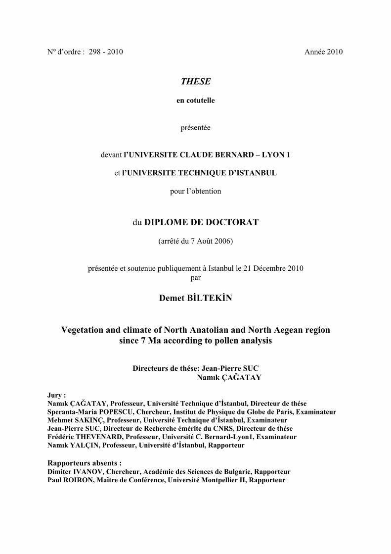
2.1.2.2 Greece and Macedonia
The climate in Greece is a Mediterranean type climate with dry and hot summers
(Mariolopoulos, 1938). Between October and March exist cold and rainy period,
from April to September, warm and dry period exist. The coldest months are January
and February with average minimum temperature ranging between 5-10 degrees
Celsius. Rainfall is high on the west coast, about 1000 mm (Mariolopoulos, 1925).
The main factors controlling the climatic conditions in Greece are the atmospheric
circulation, the latitude, the altitude and generally, the orography, the Mediterranean
sea surface temperature (SST) distribution, the land-sea interactions (distance from
the sea) and smaller-scale processes (Lolis et al. 1999). In Greece, there are five
climatic regions. These regions are :

17
Figure 2.3 : Macroclimate types of Turkey. Ia: Anatolian steppe climate; Ib: Southeastern Anatolian steppe climate; IIb: Central Black Sea climate; IIc: Western Black Sea climate; IIIa: Mediterranean climate; IIIb: Marmara climate; IVa: All seasons with precipitation type; IVb: Arid summer type (modified from Erinç, 1996).
18
1) in the western coast of Greece and the islands of Ionian Sea which take high
amounts of precipitation. The maximum precipitation observed in autumn and a
minimum precipitation occurs during the summer. The annual temperature range is
small in this region,
2) in the Aegean region (the islands of the Aegean Sea and the west coast of southern
Greece) exist low winter temperatures, high summer temperatures and low
precipitation. The annual precipitation is on average,
3) in the northern and the central part of Greece is characterized by long duration
storms, short drought periods, low temperatures during winter and large annual
temperature range,
4) in Crete and the southern Greece characterize the Mediterranean desert type
climate with low annual precipitation and droughts of long duration,
5) in the Pindous Mountain range which divides Greece into western and eastern
regions, and the mountains of northern, central and southern Greece. The climate in
this region is the typical climate of mountain areas with high annual precipitation and
strong gradients of precipitation and temperature with elevation (Loukas et al.,
2001).
The frontal depressions approaching Greece (from January to April) are rain
producers along the western coast of Greece and in the central Aegean Sea. During
winter, in the Atlantic near the Gibraltar Strait depressions originate. High rainfall is
limited to the islands and the coastal areas of Ionian Sea with some influence in
Thessaly (central Greece). The frontal depressions approaching Greece from the
west, they cause southwest winds over the Ionian and Aegean Seas forcing the
maritime air eastwards (Xoplaki et al., 2000). During summer, the high pressure
belts of the subtropics drifts northwards. In Macedonia, the climate is characterized
by the submediterranean to a continental and mountainous climate. However, the
Mediterranean climate basically influences. An Average daily temperature exist in
Skopje, ranging from 32° to -3° (Kendrovski, 2006). Continental climate occurs in
the central part of Macedonia. The average annual temperature is 12°C and summer
temperature is 19°C (April-September).
During winter, an average temperature is 5°C between October and March
(Hristovski et al., 2007). In addition, in winter, there is little wind and rain. In

19
addition during this season, a slight lowering of pressure over central eastern Europe
brings low-pressure zone over the Mediterranean. The cyclonic depressions in the
winter months follow one another from west to east over the Mediterranean. Spring
and Autumn are signed by heavy thunderstorm which cause rainfall. The dry season
lasts two months in Macedonia (Ogilvie, 1920).
2.1.3 Stratigraphy of the study areas
The Marmara region mainly consists of the İstanbul and the Strandja zones to the
north, the Sakarya zone and İzmir-Ankara Zone to the south. These zones are
overlain by fore-arc Thrace Basin rocks formed during Eocene-Oligocene time.
Today, these zones are seperated from each other by the major structural elements
(suture zones/transform faults). The northern shorelines of Marmara Sea are
generally cliffy and shore type includes pocket beaches. Neogene rocks are widely
distributed in the NE Aegean, around of the Sea of Marmara and Greece (Fig. 2.4).
In the north-west Marmara shorelines, south of the North Anatolian Fault, from
Gaziköy westward, along the Çanakkale shorelines, there exist Miocene micaceous
quartz sandstones (Kirazlı and Gazhanedere formations) (Türkecan and Yurtsever,
2002).
Kirazlı Formation conformably overlies the Gazhanedere Formation, and consists of
cross-bedded, yellow sandstones with rare mudstone and conglomeratic
intercalations in the northern Gulf of Saros. The overlying Alçıtepe Formation is
widely distributed in the Sea of Marmara and the Gulf of Saros regions (Sayar, 1987;
Sümengen et al., 1987; Siyako et al., 1989; Görür et al., 1997; Çağatay et al., 1999;
Sakınç et al., 1999; Görür et al., 2000).
Alçıtepe Formation lies conformably over the Kirazlı Formation (Sakınç et al., 1999;
Yaltırak et al., 2000). However, other workers claim unconformable relationship
between the Kirazlı and Alçıtepe Formations (Armijo et al., 1999; Melinte et al.,
2009).The nannofossil data show that the age of the Alçıtepe Formation is younger
than the Messinian Salinity Crisis (Melinte et al., 2009). The Alçıtepe Formation
demonstrates different facies characteristics in the northern coast of the Gulf of Saros
and Gelibolu and Biga peninsulas.

20
In Enez, (NW of the Gulf of Saros), the Alçıtepe Formation (Mactra-bearing
limestone section) is 23-m thick and includes a rich and sandstone intercalations in
the upper part . The formation is overlain unconformably by the alluvial fan deposits
of the Conkbayırı Formation in the Gelibolu Peninsula. The Alçıtepe Formation
contains mudstone and marl in the lower part, bioclastic and oolitic limestones with
marl in the upper part in the Gelibolu and Biga peninsulas. It is overlain with an
erosional unconformity by the Göztepe Formation (NN12 zone), composed of
shallow marine siltstone and sandstone with ostrea banks and mollusc-rich sandy
interbeds towards the upper part.
The DSDP 380 Black Sea core includes five stratigraphic units and fourteen sub-
units identified by Ross (1978). Unit 1 consists of terrigenous sediments, including
muds, sandy silts. Unit 2 includes aragonite, sideritic and calcitic siltstone,
interbedded in muds. Unit 3 compose of seekride, including calcitic oozes and marls.
Unit 4 includes calcitic, sideritic, aragonitic and dolomitic, interbedded in muds and
Unit 5 consists of Black shales with dolomite and zeolitic silt intercalations (Fig.
2.5).
Neogene rocks in the Florina-Ptolemais-Servia (FPS) Basin (Upper Miocene-Lower
Pliocene) is located in Greece. The lacustrine sediments in this basin are appeared in
a series of open-pit lignite quarries. The age of the Ptolemais section is between 5.3
and 3.9 Ma (Van Vugt et al., 1998; Steenbrink et al., 2000). The Florina, Ptolemais
and Servia sub-basins are located between 300 and 700m above the sea level. These
sub-basins are surrounded by mountains (∼2000 m) that consist of Mesozoic
limestones, Upper Carboniferous granites and Paleozoic schists.
The Late Miocene-Early Pleistocene lake sediments contain lignites and alluvial
deposits. The studied stratigraphic sections include four lithostratigraphic units:
Komnina Formation, Ptolemais Formation, Proastio Formation and Perdika
Formation. The Ptolemais Formation is ∼110 m thick and includes alternation of
lignites and lacustrine marls with fluvial sand, silts and some volcanic ash
intercalations.

21
Figure 2.4 : Distribution of Neogene rocks in the Marmara regions and North Aegean (simplified from Türkecan and Yurtsever, 2002; Okay et al., 1996 and Aldanmaz, 2002; Bornovas et al., 1983) and numbers: 1; DSDP Site 380, 2; Enez, 3; Burhanlı, 4; Eceabat, 5; west Seddülbahir, 6; İntepe, 7; Trilophos, 8; Lion of Amphipoli, 9; Prosilio, 10; Ptolemais (Notio and Base).

22
Figure 2.5 : Stratigraphy of studied sedimentary sections in DSDP Site 380, İntepe, Enez and Ptolemais.

23
The age of the Ptolemais Formation is Early Pliocene (MN 14 and 15) based on
paleontological data, magneto- and cyclo-stratigraphy and 40Ar/39Ar dating ( Van
Vugt et al., 1998; Steenbrink et al., 1999). The Komnina Formation is approximately
300 m thick and overlays uncorformably the pre-Neogene basement. The formation
contains alluvial sands, conglomerates, lacustrine marls and clays with some
intercalated lignite seams (Steenbrink et al., 2006).
The middle part of the Komnina Formation is dated as the Late Miocene based on the
small mammals (de Bruijn et al., 1999), magneto and cyclo-stratigraphy (Steenbrink
et al., 2000). The Prosilio section is located in 10 km SW of Servia. This section
includes ∼200 m of lacustrine and alluvial sediments (marls, lignites, clays, sands
and conglomerates) (Steenbrink et al., 2006).
2.1.4 Paleogeography
Paleogeography affects the climate, and thus also influence vegetation and fauna.
During the Neogene, convergence between the Eurasian plate and African plate
caused Tethys to close and form in it place the Mediterranean Sea and Paratethys
(Meulenkamp and Sissingh, 2003). Paratethys realm includes a part of the Alps,
Carpathians, Pannonian, Dacic and the Euxinian basin (Black Sea, Caspian Sea and
Aral Sea today). In the Late Tortonian (Pannonian), larger portions of northern Peri-
Tethys were emerged and extensive sedimentation started to break up in the western
and central domains. During this time, alluvial deposits and lacustrine carbonates
accumulated in the Ebro Basin (NE Iberia) (Meulenkamp et al., 2000b).
In the central Europe, brackish to fluviolacustrine conditions existed in central
Paratethys in the Late Tortonian. Mediterranean marine connection with intra-arc
domains no longer existed. Ephemeral marine ingressions in the outer Carpathian
were restricted to Dacic basin. The sediments of the Late Tortonian (Middle
Maeotian) includes nannoplankton assemblages indicating the lower part of NN11
zone (Fornaciari et al., 1997; Marunteanau and Papaianopol, 1998). In addition, in
the Late Tortonian Dacic basin became a part of the Eastern Paratethys. In the latest
Early to earliest Middle Miocene, marine invasion occurred in the central part of
Arabian Platform. However, sea regressed during the late Middle Miocene
(Meulenkamp et al, 2000b) (Fig. 2.6).

24
In the late Miocene (Late Messinian; Late Pannonian-Early Pontian), the Messinian
Salinity Crisis affected the Mediterranean basins (Fig. 2.7). Evaporites were
deposited in different depths (Popov et al., 2006). According to the largely accepted
hypothesis (CIESM, 2007; Clauzon et al., 2001), sea level drop occurred in two steps
seperated by a flooding event. The first step (5.8 Ma), Mediterranean margins were
impacted (sea-level fall of ca. 150 m). The second step occurred in an outstanding
sea level fall of about 1500 m at 5.6 Ma and effected the whole basin (Clauzon et al.,
1996). The Paratethys had a strong influence on the Mediterranean region during the
Messinian Salinity Crisis. Between the two low-stand phases, the Lago Mare event
took place probably originating from the Paratethys (Cita et al., 1978a).
Figure 2.6 : Paleogeographic map of the Late Tortonian (8-7 Ma), indicating position of continental, shallow and deep basins. Thick black lines show fault zones (modified from Meulenkamp et al., 2000b; Meulenkamp and Sissingh, 2003).

25
Figure 2.7 : Palinspastic paleogeographic map for Late Miocene (Late Messinian, Late Pannonian-Early Pontian) showing shallow and deep basins (modified from Popov et al., 2006; Olteanu and Jipa, 2006).

26
The Lago Mare facies is characterised by common brackish shallow water fauna:
Congeria, Dreissena, Melanopsis among molluscs; Cyprideis pannonica gr.,
Loxoconcha, Tyrrhenocythere, etc., among ostracods (Ruggieri, 1967; Cita and
Colombo, 1979) and endemic Paratethyan dinocycts Galeacysta etrusca (Müller et
al., 1999; Bertini et al., 1995; Bertini, 2002). In the Late Messinian (Early Pontian),
Eastern Paratethys reached its maximum areal extention (Popov et al., 2006) (Fig.
2.8). The eastern and northern margins of the early Pontian basin was caused by the
transgression (Popov et al., 2004). At the same time, paleogeographic changes was
controlled by regional tectonics, and the desiccation of the Mediterranean and Black
seas that were partly coeval during the Messinian took place (Armijo et al., 1999;
Görür et al., 1997, 2000; Gillet, 2004; Clauzon et al., 2005; Melinte et al., 2009).
Significant paleogeographic changes occurred during the Late Miocene in the eastern
Mediterranean. During the Messinian, the MSC effected on terrestrial and marine
ecosystems (i.e., planktonic foraminifers, calcareous nannoplankton and
dinoflagellates). The MSC has been observed all over the Mediterranean region
including Aegean Sea. The rocks of Messinian-Early Zanclean age are widely
distributed in northwestern Turkey. The Messinian erosional surface has been
observed in the Mediterranean area and Eastern part of Black Sea (Clauzon et al.,
1996). Some localities indicate discontinuity occurred by weak erosion in İntepe
(Çağatay et al., 2007, Melinte et al., 2009). During the Late Miocene, continental
and marine sedimentation existed in northern Anatolia (Görür et al. 1997).
Marine sedimentation existed in the Black Sea area. Continental sedimentation
developed in basins formed by the North Anatolian Fault which initiated during the
Early-Late Miocene (Barka and Hancock, 1984; Barka, 1985, 1992). Mediterranean
extensively dried up (Hsü, 1972, 1974; Adams et al., 1977; Ryan and Cita, 1978) and
also Black Sea desiccated (Gillet, 2004; Popescu, 2006) during the Messinian.
Paleogeography of the studied region covering time-window from the Early
Messinian to the Latest Messinian-Earliest Zanclean is shown in Figs. 2.8-2.9. Pollen
records from the studied areas provide information about palaeoenvironments just
before and just after the Messinian Salinity Crisis (Melinte et al., 2009). Herbs were
abundant before the Messinian Salinity Crisis in Burhanlı, Eceabat and İntepe
sections.

27
Figure 2.8 : The Paleogeographic map of Marmara region and Greece and Macedonia before the Messinian Salinity Crisis (Early Messinian) (modified from Görür et al., 1997; Sakınç et al., 1999; Vasiliev et al., 2004; Çağatay et al., 2006; Melinte et al., 2009; Krijgsman et al., 2010).
Figure 2.9 : The Paleogeographic map of Marmara region and Greece and Macedonia after the Messinian Salinity Crisis (Latest Messinian-Earliest Zanclean) (modified from Sakınç and Yaltırak, 2005; Rögl and Steininger, 1983; Meulenkamp and Sissingh, 2003; Suc, J.-P., personal data).

28
Black Sea witnessed desiccation during the Messinian Salinity Crisis (Hsü and
Giovanoli, 1979), as indicated by the 19 m thick ‘’Pebbly Breccia’’ (containing
blocks of stromatolitic dolomite) in DSDP Drill Hole 380 (Ross et al., 1978). This
presumably produced a shorter break in the pollen record. In addition, diatom data of
the Black Sea hole suggests that Black Sea was very shallow at that time (Schrader,
1978). Deep dessicated basin evaporates were deposited during that time. At this
time, suptropical and warm-temperate trees were abundant in the southwestern Black
Sea (Popescu, 2006). Before the MSC, in northern Greece (Prosilio), meso-
microthermic (mainly Tsuga) and microthermic trees (Abies and Picea) are abundant.
This could be explained as by uplifting of the surrounding region.
The connections between the Mediterranean and Paratethys were enabled after the
Messinian Salinity Crisis. During the Pliocene time interval, the Mediterranean Sea
was inundated by marine waters due to the connection with Atlantic Ocean after the
Messinian Salinity Crisis (Hsü and Bernoulli, 1978). Early Zanclean reflooding
occurred within two steps: collapse (at 5.480 Ma) and widening (at 5.330 Ma) of the
Gibraltar Strait (Clauzon et al., 2007). During the Early Pliocene, northern margin of
the Sea of Marmara Basin was uplifted and eroded, while the southern margin turned
into continental areas (Görür, et al., 1997). At the Latest Messinian-Earliest Zanclean
(after MSC), altitudinal conifers (Cedrus, Abies, Picea and Pinus) indicate an
augmentation in the north-western Aegean (i.e, İntepe and west Seddülbahir).
This could indicate uplifting of the region. Indeed, uplifting occurred during the
Messinian due to propagation of the North Anatolian Fault (NAF) (Armijo et al.,
1999; Melinte et al., 2009).
During the Middle Pliocene (Piacenzian)-Early Pleistocene (Gelasian), Iberian
domain emerged. In these basins which located in south-eastern Iberia (Aguirre,
1998) and Atlantic coast, alluvial and shallow marine sediments deposited (Fig.
2.10). In the central Paratethys (intra-Carpathian domains) continental clastic
accumulated in the Middle Pliocene-Early Pleistocene. Back-arc basin in the south-
western part were filled with Pliocene deposits (reaching thickness about 1000 m)
(Meulenkamp et al, 1996). In addition, widespread volcanism occurred in the Styrian
and Danube basins, Great Hungarian plain, South Slovakian-North Hungarian
volcanic domain and south-eastern Transylvania (Szabo et al., 1992).

29
Nevertheless, the faunal composition of Dacic basin changed significantly
(extinction of Limnocardiids and appearance of Unionids, Viviparids and
Melanopsids) during the Pliocene (Meulenkamp et al, 2000b). Eastern Paratethys
contained two major basins (Dacic-Euxinian basin system and the Caspian basin)
since latest Miocene (Late Pontian). In the Caspian basin occurred a major regression
with reduction of salinity in the Early Pliocene. The Akchagylian Sea was
characterised by low salinity and euryhaline biotas (Meulenkamp et al, 2000b).
Pollen assemblages and macroplant fossils (leaf remains) show that existence of a
forested hinterland with similar to those of present-day taiga.
Figure 2.10 : Paleogeographic map of the Piacenzian-Gelasian (3.4-1.8 Ma), indicating position of continental, shallow and deep basins. Thick black lines show fault zones (modified from Meulenkamp et al, 2000b; Meulenkamp and Sissingh, 2003).
They show climatic conditions changing from cool and dry towards relatively warm
and wet (broad-leaved forest zone; Neogene System, 1986). The connection between
the Mediterranean and Paratethys during the Late Pliocene is also supported by its
faunal assemblages in the sediments.

30
The faunal distribution of the sediments shows that the Marmara Basin was firstly
invaded by Paratethys and then by the Mediterranean during the Late Pliocene. At
the begining of the Pleistocene (2.6 my ago), the climate got cooler and glacial-
interglacial cycles appeared in the Northern Hemisphere. This is also well recorded
in the pollen spectra. For instance, Artemisia steppe became important during the
glacial periods (DSDP Site 380). At the interglacial periods, forest formations
developed. Nevertheless, during glacial periods, the Sea of Marmara was isolated
from the Mediterranean and became a brackish water environment and reconnected
during the Quaternary interglacials including the Early Holocene (Stanley and
Blanpied, 1980; Smith et al., 1995; Aksu et al., 1999; Çağatay et al., 2009).

31
3. METHOD
Palynology is the science of the present and fossil palynomorphs such as pollen,
spores, dinoflagellate cysts and acritarchs. Because of the strong wall (exine) of the
pollen grains, they can be well-preserved for a longtime in the sediments. Pollen
provide a high resolution and continuous record of climate. Palynology is especially
a very good tool for assessing paleovegetation and paleoclimate history. In addition,
palynological studies are used for biodiversity, biostratigraphy and characterisation
of the past environmental changes.
Samples used in this study are located in the western Black Sea (DSDP Site 380),
NW Turkey (İntepe, Burhanlı, Eceabat, West Seddülbahir, Enez) and Northern
Greece (Prosilio, Trilophos, Lion of Amphipoli) and Western Macedonia (Ptolemais
Notio and Ptolemais Base) (Fig. 1.2). Pollen grains are generally well preserved in
the sediments. In this study, a total of 436 samples have been analysed (Table 3.1).
378 of these samples (Late Miocene-recent) are from the Black Sea DSDP borehole
and the remaining 58 samples come from outcrops (Late Miocene-Early Pliocene).
The four samples (374.5, 376, 413 and 593 m) from Black Sea core, three samples
(samples 1, 2 and 3) from Trilophos, three samples (samples 1, 3, 4, and 5) from
Eceabat, five samples (samples 1, 2, 4, 5 and 6) from Burhanlı, two samples (samples
1 and 2) from Ptolemais Notio are barren (containing no or very low number of
pollen grains).
The high-resolution long-term pollen record of DSDP Site 380 completely covers the
last 7 million years. The top 0-308.46 m was analysed by S. Boroi, and the lower part
704.34-1019.85 m by S.-M. Popescu. In this thesis, the studied interval of the DSDP
borehole covers the interval between 319.030 and 702.4 meters the middle part of the
hole.

32
Table 3.1: Study locations and number of samples.
3.1 Sampling and Chemical Processing
Sampling intervals were taken differently. In DSDP 380 Site, samples were taken
approximately at 0.5 m intervals. The outcrop samples have a one meter intervals.
The sampling were done always with maximum precaution to avoid the
contamination of samples. For the chemical treatment ca. 20 grams sediment was
used. The samples were processed using the classical method of Cour (Cour, 1974).
The analysis was processed as indicated below:
1. Weighted ca. 20 grams sediment (depending on the sort of sediment),
2. Remove carbonate content of sediment using HCl acid (35%) for 12 hours,
3. Add water twice,
4. Eliminate silicates in the sediment using HF acid (70%) for 24 hours,
5. Add water twice,
6. ZnCl2 (density>2) is used to separate palynomorphs in the sediments, and then
samples are centrifuged at 1000 r.p.m. for 10 minutes,
7. Add HCl acid (35%) to dissolve minerals which are left during ZnCl2 reaction,

33
8. Centrifuge at 2500 r. p. m. for 5 minutes,
9. Wash deposited samples 2 times to eliminate ZnCl2 and HCl acid at 2500 r. p. m.
for 10 minutes,
10. Sieve the remaining residue using 10 µm nylon sieve,
11. Centrifuge again to remove remaining water at 2000 r. p. m. for 10 minutes,
12. Add glycerol. The glycerol is added as much as final residue,
13. Calculate the volume of resude sediment with glycerol,
14. Mount samples on slide by placing the residue 50 ml, adding glycerol, covering it
with the thin slide cover and sticking it with glue (histolaque).
3.2 Identification of Pollen Grains
The analysis on the microscope has been performed using two light-transmitted
microscopes (alternately in İstanbul and Lyon), Zeiss and Leica with different oil-
immersion objectives (x25, x40 and x100). The analysis consisted in identifying and
counting pollen grains along several lines. Spores were not considered due to their
poor presence in the sediments. The identification was done from end to end parallel
to the longest edge of the slide. So, the same pollen grain could never be encountered
twice in this way.
The pollen grains where counted until of minimum 150 pollen excluding Pinus.
Because Pinus is generally overrepresented owing to their prolific production and
having ability of transportation in air and water. The botanical identification is made
by the study of morphological characters of pollen grains, which are compared with
the living relatives. Pollen identification benefited from many pollen photographs,
atlases, and also Photopal website (http://medias.obs-mip.fr/photopal). All pollen
data are available on the web from the “Cenozoic Pollen and Climatic values”
database (CPC) (http://cpc.mediasfrance.org).
In this study, 107 different taxa were identified. During the analysis, several pollen
species were photographed (in Figs. 3.1 and 3.2). However, some pollen grains
could not be identified because of their poor preservation, and so they were defined
as indeterminable in the pollen diagrams. All identified taxa and species are shown in
Table 3.2. Complete pollen data are presented in the form of synthetic pollen
diagrams (Suc, 1984) and detailed pollen diagrams. In this kind of detailed pollen
diagrams, taxa are individually indicated with their percentage.

34
Table 3.2: Taxa identified in the study.

35
In synthetic pollen diagrams, different taxa are grouped into 12 different groups
according to the ecological significance of their living relatives (Table 3.3). Thus,
such diagrams allow comparison with the other pollen records obtained from the
other localities, such as the European and Mediterranean regions.
Table 3.3: Groups used in synthetic pollen diagrams according to classification of Nix (1982).
Moreover, they are also convenient for comparison with oxygen isotope curves in
order to contribute to reconstruction of paleoclimate evolution. The groups used in
the synthetic diagrams are from left to right:
• Megathermic (tropical) elements: Avicennia alba, a mangrove tree;
Euphorbiaceae, Rubiaceae, Rutaceae, Arecaceae, etc.;
• Mega-mesothermic (subtropical) elements: mainly Taxodiaceae (including
Taxodium type and Glyptostrobus), Engelhardia, Sapotaceae, Microtropis
fallax, Distylium;
• Cathaya, a conifer living today at mid-altitude in subtropical China;

36
• Mesothermic (warm-temperate) elements: deciduous Quercus, Carya,
Pterocarya, Carpinus orientalis, Juglans, Juglans cf. cathayensis, Celtis,
Zelkova, Ulmus, Tilia, Acer, Liquidambar cf. orientalis, Alnus, Salix,
Populus, Fraxinus, Buxus sempervirens type, Betula, Fagus, Hedera,
Lonicera, Ilex, Tilia, etc.;
• Pinus;
• Meso-microthermic (mid-altitude) elements: Cedrus and Tsuga;
• Microthermic (high-altitude) trees: Abies and Picea;
• Non-significant elements: some cosmopolitan or widely distributed elements
such as Rosaceae and Ranunculaceae;
• Cupressaceae;
• Mediterranean xerophytes: Quercus ilex type, Olea, Phillyrea, Ligustrum,
etc.;
• Herbs: Poaceae, Amaranthaceae-Chenopodiaceae, Asteraceae Asteroideae,
Asteraceae Cichorioideae, Geranium, Convolvulus, Erodium, Lamiaceae,
Plantago, Euphorbia, Brassicaceae, Apiaceae, Rumex, Polygonum,
Cyperaceae, Campanulaceae, Ericaceae, Solanaceae, etc.; some halophytes
such as Caryophyllaceae, Plumbaginaceae are included within the herbs;
some herbs contain water plants such as; Potamogeton, Sparganium and
Typhaeae,
• Steppe elements: Artemisia, Ephedra and Hippophae rhamnoides.

37
PLATE 1
1, Abies (Ptolemais Base);
2-4, Acer (Ptolemais Base);
5-7, Galium (Ptolemais Base);
7-11, Cistus (Ptolemais Base);
12-14, Fagus (Ptolemais Base);
15-16, Lamiaceae (Ptolemais Base);
17-19, Myrica (Ptolemais Base);
20, Typha (Ptolemais Base);
21, Rosaceae (Ptolemais Base);
22, Zelkova (Ptolemais Base);
23, Alnus (Ptolemais Notio);
24, Apiaceae (Ptolemais Notio);
25, Asteraceae Asteroideae (Ptolemais Notio);
26, Carya (Ptolemais Notio);
27, Caryophyllaceae (Ptolemais Notio);
28, Engelhardia (Enez);
29, deciduous Quercus (Ptolemais Base);

38
Figure 3.1 : Some pollen photos from the studied regions.

39
PLATE 2
30, Cedrus (Ptolemais Notio);
31, Tsuga (Ptolemais Notio);
32, Lonicera (Ptolemais Notio);
33, Avicennia alba (DSDP Site 380);
34, Polygonum (Ptolemais Notio);
35, Tilia (Ptolemais Notio);
36, Pterocarya (Ptolemais Base);
37, Carpinus orientalis (Enez);
38, Amaranthaceae-Chenopodiaceae (Enez);
39, Taxodiaceae: probably Glyptostrobus (DSDP Site 380);
40, Sparganium (Enez);
41, Artemisia (DSDP Site 380);
42, Corylus (Trilophos);
43, Poaceae (DSDP Site 380);
44, Asteraceae Cichorioideae (Ptolemais Notio).

40
Figure 3.2 : Continued.

41
4. CHRONOLOGY OF THE STUDIED SECTIONS
A total of 10 sections and 436 samples have been studied for pollen analysis (in
Table 1). The chronology of studied sections are mainly supported by calcareous
nannoplankton data and other biostratigraphic data (Table 4.1). The
chronostratigraphy of the studied locations are given in Figure 4.1. In the DSDP
Black Sea core, firstly, seventeen samples were selected corresponding to warm
phases in the pollen diagram for nannofossils. These depths are 219, 223.02, 326.14,
334.50, 368.43, 461.53, 471.50, 476.46, 504.35, 509.35, 518, 548.50, 586.49, 682.95,
708.20, 748.45, and 840.07 mbsf. The eight of the seventeen samples yielded
nannofossils. The corresponding depths are 219, 223.02, 326.14, 368.43, 476.46,
504.35, 748.45, and 840.07 mbsf. These chronological limitations are assigned in the
sediments using ages of the lowest occurrence (LO), highest occurrence (HO), lower
consistent occurrence (LCO) and highest consistent occurrence (HCO) of the species
as determined by Raffi et al. (2006):
at 840.07 m depth, Triquetrorhabdulus rugosus and Ceratolithus acutus are
observed. The age is between 5.345 Ma (C. acutus LO) and 5.279 Ma (T.
rugosus HO) (early Zanclean);
at 748.45 m depth, Reticulofenestra pseudoumbilicus displays an age older
than 3.839-3.79 Ma (R. pseudoumbilicus HO) (late Zanclean);
at 476.46 m and 504.35 m depth, Discoaster brouweri displays an age
older than 2.06 – 1.926 Ma (D. brouweri HO) (late Gelasian);,
at 368.43 m depth, medium-sized Gephyrocapsa shows an age
younger than 1.73 – 1.67 Ma (medium-sized Gephyrocapsa spp. LO)
(Calabrian),
at 326.14 m depth, Helicosphaera sellii exhibits an age older than 1.34-1.256
Ma (H. sellii HO) (Calabrian).
at depths 223.02 and 219 m, the presence of Reticulofenestra asanoi displays
that these samples are between 1.136 Ma (R. asanoi LCO) and 0.901 Ma (R.
asanoi HCO) (Calabrian).

42
Figure 4.1 : The chronostratigraphic position of the studied sections from the Late Miocene to the Early Pleistocene.
Samples from the studied sections in the Gulf of Saros (Enez) and Dardanelles
regions (İntepe, west Seddülbahir, Burhanlı, Eceabat) were analysed for
nannoplankton. The Enez section contain poor to moderate nannoflora in 7 samples.
They indicate the co-occurrence of Triquetrorhabdulus rugosus and Ceratolithus
acutus. They represents NN12b nannofossil subzone indicating the extreme end of
Messinian (after the MSC) to earliest Zanclean (Melinte et al., 2009). The studied
sections in the Dardanelles are correspond with the Messinian erosional surface
(Melinte et al., 2009).
The nannoflora content of Eceabat indicates poor to moderate preservation and few
reworked specimens. They contain Amaurolithus primus, Reticulofenestra
pseudoumbilicus, R. Rotaria (samples 1, 2, 4, 5), Nicklithus amplificus (samples 1
and 3) and Triquetrorhabdulus rugosus. This nannoflora indicates NN11c
nannofossil subzone. It belongs to an early Messinian age (Melinte et al., 2009). The
nannofloral community of west Seddülbahir includes Triquetrorhabdulus rugosus,
Reticulofenestra pseudoumbilicus, Ceratolithus acutus.

43
Table 4.1: Age control of the study areas.
Study Location Country Age determination Age Pollen Analysis DSDP Site 380 Turkey, near the
Bosphorus Melinte, M. C. (personal information)
Pliocene-Lower Pleistocene
S. Boroi, D. Biltekin, S.-M. Popescu
İntepe Turkey Melinte et al., 2009 Early-Late Messinian-Early Pliocene
J.-P. Suc, D. Biltekin
Eceabat Turkey Melinte et al., 2009 Early Messinian D. Biltekin Burhanlı Turkey Melinte et al., 2009 Latest Tortonian-Early
Messinian D. Biltekin
West Seddülbahir Turkey Melinte et al., 2009 Latest Messinian-Earliest Zanclean
J.-P. Suc
Enez Turkey Melinte et al., 2009 Messinian (after MSC)-Earliest Zanclean
D. Biltekin
Ptolemais Notio and Ptolemais Base
Macedonia van Vugt et al., 1998, Steenbrink et al., 1999
Early Pliocene D. Biltekin
Prosilio Greece Steenbrink et al., 2000,2006
Late Miocene D. Biltekin
Lion of Amphipoli Greece Melinte, M. C. (personal information)
Early Zanclean J.-P. Suc
Trilophos Greece Melinte, M. C. (personal information)
Latest Messinian-Earliest Zanclean
D. Biltekin

44
The age of this section is from NN12a to NN12b subzones, from the latest Messinian
to the earliest Zanclean (Melinte et al., 2009). In the Burhanlı section, nannoflora
community; Reticulofenestra pseudoumbilicus, Reticulofenestra rotaria,
Triquetrorhabdulus rugosus and Nicklithus amplificus were recorded in the samples.
According to this nannoflora assemblages, age of section is the latest Tortonian to
early Messinian (upper part : NN11b subzone; lower part: NN 11c subzone). In the
İntepe section (samples from 18 to 24), the nannofossil content of sediments are
Amaurolithus primus, Reticulofenestra rotaria (samples 14-18), Nicklithus
amplificus (samples 1-7), Triquetrorhabdulus rugosus (samples 1-31) and
Ceratolithus acutus corresponding to NN11c and maybe NN12a subzone.
The age of samples from Western Macedonia and Northern Greece (Ptolemais Notio
and Base, Prosilo, Trilophos and Lion of Amphipoli) were also determined. The age
of the Ptolemais Formation is based on paleontological data (small mammals) and
magneto- and cyclostratigraphy and 40Ar/39Ar dating, according to which it is the
Early Plioecene (MN 14 and 15) ( van de Weerd, 1979; van Vugt et al., 1998;
Steenbrink et al., 1999). In Trilophos and Lion of Amphipoli, datation is based on
nannofossils. According to this, Lion of Amphipoli is in the Early Zanclean age
(Melinte, M.C., personal correspondence). The nannoflora of Trilophos was analysed
in five samples.
Only two samples (samples 4 and 5) have nannoplankton content. The
nannoplankton assemblages in Trilophos contain Triquetrorhabdulus rugosus,
Reticulofenestra pseudoumbilicus, Ceratolithus acutus, which belongs to NN12 a, b
subzones (the latest Messinian to the earliest Zanclean) (Melinte, M.C., personal
correspondence). The indirect age determination for Prosilio section is based on
correlation of thick green clay bed with abundant fish teeth and vertebrate.
This bed has been found in the 5 km easterly Lava quarry dated as 6.57 Ma years
(Steenbrink et al., 2000). The correlation of polarity sequence in Prosilio section
(Late Miocene) with geomagnetic polarity time scale gives the lower normal
polarity; subchron C3An.2n, middle normal interval with C3An.1n and the upper
interval with Thvera (Steenbrink et al., 2006).

45
5. RESULTS
5.1 DSDP Site 380
The Black Sea borehole was taken from near the Bosporus on the basin apron in a
water depth of 2107 meters (southwestern Black Sea). The length of the core is
1073.5 meters (42°05.94'N and 29°36.82'E). In this thesis, 319.03 to 702.4 mbsf
interval was studied which correspond to Units (Unit 2 and Unit 4(4a) in Figure 5.1.
5.1.1 Lithology
The sedimentary sequence of the core is divided into five main units and 13 subunits
(Fig. 5.1) (Ross, 1978). These units and subunits are described below:
UNIT 1 (0-332.5 m)
In this unit includes mainly terrigenous sediments. The sediments are silty clay,
sandy silts, and rare sands as thin laminae. The silts, sands and muds comprise
feldspars, quartz, clay minerals, detrital carbonates, pyrite, organic matter, heavy
minerals and diatoms. The clay minerals consist mainly of illite and smectite, with
smaller amounts of kaolinite and chlorite. In addition, detrital carbonates exist in a
small amounts. Unit 1 contains sediments which were depositied during the marine
incursions and the intervening lacustrine periods. This unit is subdivided into five
subunits, the first two of which were not recovered by the DSDP coring:
Subunit 1a:
This subunit is generally represented by a 30 cm-thick laminated in Black Sea cores.
In general, this subsunit is a typical sediment of the present Black Seadeposited in
the last 3000 a. It consists of nannofossil (coccolithophore) ooze (Ross and Degens,
1974).
Subunit 1b (0-2 m):
The Subunit 1b is a dark gray sapropel and rich in organic matter and diatoms. Its
age spans from 8 ka to 3 ka.

46
Subunit 1c (2-42 m):
The subunit 1b includes muds and sandy silts. This subunit is the one of the sandy
intervals at this hole. Silty sands compose of micas, detrital carbonates, quartz,
feldspars, heavy minerals, clays, opaque minerals and shell components. The
terrigenous sediments are micaceous.
These sediments were deposited under lacustrine, fresh to brackish water
environment. This is supported by the presence of fresh-water diatoms, such as;
Stephanodiscus and Melosira.
Subunit 1d (45-76 m):
This subunit constitutes chiefly diatomaceous muds. During the deposition of this
unit, marine influence was dominant. Diatoms are generally marine. However, The
sacarcity of foraminifers and nannofossil communities show that the environment
was not under fully marine conditions. The presence of Gephyrocapsa sp. indicates
that salinity of Black Sea was more than 18‰ (Percival, 1978 and Bukry, 1973).
This subunit is the first brackish-marine sequence below the Holocene (Marine
Isotope Stage 5e).
Subunit 1e (76-142.5 m):
This subunit includes terrigenous sediments. The silts and muds consist of quartz,
feldpars, clay minerals and detrital carbonates. The one interval contains diatoms of
some brackish-water species.
Subunit 1f (142.4-171 m):
The sediments of this subunits are greenish gray to dark greenish gray. The Diatoms
are abundant. Thin sandy silts layers are common. They are in terms of quartz and
feldspar. The content of diatom species indicate brackish-marine condition.
Subunit 1g (171-266 m):
Subunit 1g chiefly contains muds. The thin silt and clay intervals are common. One
interval is diatomaceous with fresh-water species. The lithology of this subunit is
alike subunits 1c and 1e.

47
Subunit 1h (266-332.5 m):
This subunit includes muds and turbidite intervals. It includes two diatom-rich levels,
containing fresh-water species in 294.5-304 m. This subunit also contains Ammonia
beccarii, that is abundant at the bottommost part of this subunit. Thus, this indicates
that this subunit were deposited in a brackish-marine environment.
UNIT 2 (332.5-446.5 m)
The Unit 2 is represented by several interbedded of carbonate-rich layers. The upper
part of the unit includes aragonitic sediments. The bottom part of the unit contains
the lowest occurrence of siderite-rich sediments. Siderite-rich marls are observed in
thin layers or laminae. In addition, calcareous oozes are present in calcite.
The other sediment is aragonite. Also the carbonates, sapropelic and diatomaceous
muds, laminated and varve-like clays and sandy silts are observed. The dominant
lithology of this unit usually is mud. It consists of quartz, feldspars, clay minerals
and a little amount of detrital carbonates.
The color varies from greenish gray to olive gray or to dark greenish gray. The
darker sedimets are rich in terms of pyrite. However, the olive/light olive gray
sediments include diatoms and carbonates. The chemical sediments contain
aragonite, siderite and calcite. Siderite mostly is in marls. The siderite-rich layers are
light olive gray in color and from a few to numerous centimeters thickness.
Calcite-rich marls and oozes or seekride are also represented in the core. The upper
section of this unit was deposited under marine-brackish conditions. The presence of
the Braarudosphaera flora indicates that Black Sea was effected by strong marine
influence, the salinity may have reached 22‰ (Percival, 1978 and Bukry, 1973). The
oldest sediments of this unit may have been formed in a fresh or brackish lake.
UNIT 3 (446.5-644.5 m)
This unit is featured by the existence of seekreide. The dominant content of this unit
are muds, marls and seekreide. The upper section of the unit still includes siderite.
The bottom part of this unit is placed just above the diatomaceous ooze. Also this
unit consists of an ostracode fauna such as; Candona-Loxoconcha assemblages that
show the deposition in fresh-water lakes (Benson, 1978 and Olteanu, 1978).

48
Figure 5.1 : Lithology of DSDP 380 Site Black Sea core (Ross, 1978). Climate zones in the diagram: γ (Glacial), B (Interglacial), β (Glacial), A (Interglacial), α (Glacial). Studied intervals cover 319.03 to 702.4.

49
UNIT 4 (644.6-969 m)
This unit contains the various sediment types including also chemical sediments. The
upper part of the unit includes siderite layer in 664.6 meters. The bottom of the unit
is transitional to an underlying black shale. In this unit, diatoms and carbonate-rich
sediments are also present. Besides, it is noteworthy to mark the presence of pebbly
mudstones and breccias. This unit is divided into five subunits:
Subunit 4a (644.6-718 m):
This subunit is represented by the existence of several manganosiderite intercalations
in diatomaceous clay. In the upper and the bottom levels are characterized by the
siderite layers. The main lithology of this subunit are mud, diatomaceous clay and
the terrigenous sediments. In the upper section, clays are usually structureless.
However, at the lower part, they have some distinct laminations. The structureless
clay levels contain chiefly clay minerals and numerous amounts of diatoms.
The main clay mineral is smectite with illite, and a small amount of kaolinite and
chlorite. The laminated layers contain diatom-rich and clay-rich lamina. At the same
time, siderite is common in this subunit. The siderite-rich sediments are pale olive
color, thin layers or as nodules. The diatom content of the subunit suggests that
depositional environment was possibly from fresh to brackish (Schrader, 1978).
Besides, dinoflagellates are present abundantly. These suggest the marine flux
period.
Subunit 4b (718-850.3 m):
This subunit constitute seekreide. Diatomaceous clays and marls are also presented.
The upper boundary this subunit is represented by the base of the siderite. The main
sediments in this subunit are clays, calcite (chemical) and diatoms. The seekreide
varves contain calcite-rich light greenish gray and clay-rich dark greenish gray
lamina. The diatomite varves comprise light olive green calcite-bearing
diatomaceous marl and darker olive green diatomaceous clay. At the base,
dinoflagellates and acritarchs are common. The toward to upper part, they are
presented as a less amount.

50
Subunit 4c (850.3-864.5 m):
This subunit is defined by the existence of aragonite and magnesian calcite. The
main lithology of the subunit is diatomaceous shales in olive-black color. The
sediments in this subunit were formed under brackish-marine condition.
The abundance of Braarudosphaera flora shows that the salinity may have reached
22‰ (Percival, 1978 and Bukry, 1973). The existence of Bolivina indicates
stenohaline conditions (Gheorghian, 1978). Dinoflagellates and acritarchs are
common that indicate marine influence.
Subunit 4d (864.5-883.5 m):
The subunit is characterized by pebbly mudstones, stromatolitic dolomites and
conglomerates. The dolomite was deposited such in an intertidal to supratidal
environment (Stoffers, 1978). The sea level in the Black Sea was possibly very
shallow. This is also supported by shallow habitat diatoms (Schrader, 1978). The
major lithology is congolomerate, slump breccia or pebbly mudstone.
Subunit 4e (838.5-969 m):
This subunit contains dolomite which is in the form of laminated seekreide and
marls. The upper part of this subunit is above the base of the pebbly mudstone. The
main lithology is calcareous mud or marl. It has dark greenish color. Interbedded in
the marl sequence are calcitic, aragonitic and dolomitic sediments. These chemical
sediments form in three distinct sediments content: laminated marl, carbonate varves
and dolomite.
UNIT 5 (969-1073.5 m)
This unit is characterized by the presence of black shales with zeolitic sandstones and
dolomite. The black shales are in greenish black and fissile. They contain clays,
organic matter, quartz, feldspars and pyrite. The content of small benthic
foraminifers in the sequence indicate that the black shales were deposited in a
brackish-marine environment.

51
5.1.2 High-resolution pollen record of DSDP 380
In DSDP Site 380 Black Sea hole, studied interval is from 319,03 m to 702,40 m
below sea floor (mbsf) corresponding to the Early Pliocene-Early Pleistocene. High-
resolution pollen analysis of the core provides significant data for paleovegetation
and paleoclimate during the Early Pliocene to Early Pleistocene (from Zanclean to
Gelasian). The vegetation is characterized by different plants groups. Most of them
are inherited from the Miocene. Along the study intervals, the flora is dominated by
mostly two vegetation types (Fig. 5.3). They are thermophilous plants and herbs
characterizing steppe. Thermophilous vegetation is characterized by megathermic
(tropical), mega-mesothermic (subtropical) and mesothermic (warm-temperate)
elements.
Megathermic elements are Euphorbiaceae, Rubiaceae, Arecaceae, Rutaceae and
Avicennia alba. However, they are in small amount in the studied intervals. Mega-
mesothermic elements are characterized by Taxodiaceae (chiefly Glyptostrobus),
Taxodium type, Engelhardia, Platycarya and Sapotaceae. Among them, particularly
Taxodiaceae swamp forests show high abundances. Percentage of Taxodiaceae
reaches up around 80% (Figs. 5.2-5.3). Mesothermic elements contain deciduous
Quercus, Betula, Corylus, Juglans, Pterocarya, Buxus sempervirens, Liquidambar
orientalis, Nyssa, Acer, Castanea, etc.
These evergreen and deciduous mixed forest include a riparian vegetation composed
of Salix, Alnus, Carpinus orientalis, Zelkova, Carya, Ulmus, etc. The mesothermic
plants are presented frequently along studied intervals. Quercus reaches up 10% in
some levels and Zelkova reaches up 11%. Herbs are involved by mainly
Amaranthaceae-Chenopodiaceae, Poaceae, Asteraceae Astroideae, Asteraceae
Cichorioideae, Brassicaceae, Caryophyllaceae, Lamiaceae, Rumex, Apiaceae,
Centaurea, etc. At the same time, herbs include some fresh-water plants such as;
Sparganium, Potamogeton, Typha, Myriophyllum. Among herbs, Amaranthaceae-
Chenopodiaceae has higher amount. Its percentage approaches 88%. Steppe elements
comprise mainly Artemisia, Ephedra and Hippophae rhamnoides. Artemisia is
represented abundantly with a percentage of around 84% (Figs. 5.2-5.3). The rest of
steppe elements (Ephedra and Hippophae rhamnoides) do not vary significantly.

52
Figure 5.2 : Detailed pollen diagram of DSDP Site 380 between 319.03-460 m.

53
Figure 5.3 : Detailed pollen diagram of DSDP Site 380 between 460.54-702.4 m.

54
In addition, altitudinal coniferous trees such as; microthermic elements (Abies and
Picea) and meso-microthermic elements (Cedrus and Tsuga) appear in a small
number. Also, Cathaya has a less amount. Cathaya is a gymnosperm, living today in
the subtropical mid-altitude forest of southern China.
Pollen groups in the synthetic pollen diagram are: 1; Megathermic elements
(Avicennia alba, Rutaceae, Arecaceae, Rubiaceae), 2; Mega-mesothermic elements
(Taxodiaceae, Engelhardia, Taxodium type, Platycarya, Sapotaceae), 3; Cathaya, 4;
Mesothermic elements (deciduous Quercus, Betula, Alnus, Carya, Pterocarya,
Zelkova, Ulmus, Fagus, etc.), 5; Pinus, 6; Meso-microthermic elements (Cedrus and
Tsuga), 7; Microthermic elements (Abies and Picea), 8; Cupressaceae, 9; Herbs
(Amaranthaceae-Chenopodiaceae, Poaceae, Asteraceae Astroideae, Asteraceae
Cichorioideae, Brassicaceae, Caryophyllaceae, Lamiaceae, Rumex, Apiaceae,
Polygonum, etc., 10; Steppe elements (Artemisia, Ephedra and Hippophae
rhamnoides).
Mediterranean xerophytes and non-significant elements have small amounts.
Therefore, they were excluded from the synthetic pollen diagram. Pinus is
represented abundantly. Its percentage gets at 53%. The pollen record of the core
enables the identification of the different vegetation stages with subdivisions.
Additionally, these stages are correlated with oxygen isotope curve (with MIS). The
stages are described below (Popescu et al., 2010):
Pollen zone 2 (624-702,40 meters): This zone is divided into three subzones (2a, 2b,
2c) (Fig. 5.4). These pollen subzones are defined by Zagwijn, 1960; Zagwijn and
Suc, 1984. Pollen zone 2 is characterized by the abundance of herbs (mainly
Amaranthaceae-Chenopodiaceae). This show that drier climate conditions existed
during this time. On the contrary, thermophilous trees are not very much.
Nevertheless, Artemisia steppes also have a decrease in this zone. At the top of zone
2, Artemisia displays an increase.
Pollen zone 3 (603-624 meters): In this zone, herbs are abundant with Artemisia,
reaching up 59%. On the other hand, thermophilous plants have a small amounts.
This time intervals corresponds the earliest glacials in the Northern Hemisphere. This
zone matches Marine Isotope Stages (MIS 104-96).

55
Figure 5.4 : The synthetic pollen diagram of DSDP Site 380 obtained in this study. Pollen groups in the diagram: 1; Megathermic elements, 2; Mega-mesothermic elements, 3; Cathaya, 4; Mesothermic elements, 5; Pinus, 6; Meso-microthermic elements, 7; Microthermic elements, 8; Cupressaceae, 9; Herbs, 10; Steppe elements (see for explanation in the next page). The synthetic pollen diagram with oxygen isotope curve showing Marine Isotope Stages (Shackleton et al., 1990, 1995), pollen zones, NW European climatostratigraphy (Zagwijn, 1960, 1998) and nannofossil biohorizons (Raffi et al., 2006). Chronostratigraphy, Lourens et al. (2004).

56
Pollen zone 4 (603-461 meters): Pollen zone 4 is divided into three subzones. These
are 4a, 4b and 4c. This zone is dominated by chiefly thermophilous forests. Among
them, subtropical trees are particularly abundant (probably mainly Glyptostrobus).
Thermophilous trees are quickly replaced by herbs. In this zone, herb elements are
represented abundantly. Artemisia is not abundant. Its percentage is around 11% in
average. Climate fluctuations shows warmer-moister phases opposed to cooler-drier
ones, probably corresponding to glacial-interglacial cycles. This zone corresponds
the Tiglian warm period (Zagwijn, 1960; 1963; Zagwijn and Suc, 1984).
Pollen zone 5 (395-461 meters): In this zone, herbs are prominent (mostly
Amaranthaceae-Chenopodiaceae). With herbs, Artemisia shows higher frequency.
Subtropical trees do not change very much. Besides, mesothermic elements have an
increase. This zone corresponds to the Eburonian stage (MIS 62-50) (Zagwijn,
1975).
Pollen zone 6 (319,030-392,010 meters): In this zone, Herbs are abundant with
Artemisia steppes. Nevertheless, mega-mesothermic elements and mesothermic
elements are prominent. This zone corresponds Waalian phase. The subdivisions are
6a and 6b in the study intervals.
The other important result is Avicennia alba (Mangrove) and some tropical
Euphorbiaceae plants. Avicennia was observed between 781.63 meters and 1018.85
m in the lower part of the section (Popescu, 2006). In this study, it was observed at
412.53 m. On the other hand, Avicennia disappeared from North Mediterranean 14
Ma ago (Serravalian) and from North Africa at 5.3 Ma (Chikhi, 1992; Bachiri
Taoufiq et al., 2001).
According to these results, thermophilous plants persisted up till the Early
Pleistocene in the region more recently than in the other regions of Mediterranean.
Thermophilous plants were well recorded during the Pliocene time and the
Pleistocene (Fig. 5.5). Relict plants such as Carya, Carpinus orientalis, Pterocarya,
Liquidambar orientalis, Zelkova are still living in the Anatolia. This situation can be
explanied by the Asian monsoon climate effect.

57
Figure 5.5 : The distribution of thermophilous trees during the Pliocene-Pleistocene in the DSDP Site 380.

58
5.2 Gulf of Saros
5.2.1 Enez
Enez is located in the eastern shoreline of the Enez lagoon (40°46′24″ N, 26°04′ E)
near the border of Turkey with Greece. The study area includes the Pliocene and the
Late Quaternary deltaic deposits of Meriç River overlying the Kirazlı Formation
(Çağatay et al., 1998, 2006). The seven samples of eight brownish clay sediments
(thickness ∼8 m) from the Pliocene bottomset deposits in the Enez section are rich in
pollen grains. The flora are characterized by the herbaceous vegetation and warm-
temperate trees in all the samples (mesothermic elements) (Fig. 5.6). Herbs reach up
more than 75% in the lowest part of the section. Inside this group; Poaceae,
Amaranthaceae-Chenopodiaceae, Asteraceae Asteroideae, Asteraceae Cichorioideae
are abundant in the samples. The other herbs elements are: Caryophyllaceae,
Plumbaginaceae, Solanaceae, Scabiosa, Papavaraceae, Centaurea, etc. Herbs
elements also contain some water plants such as; Potamogeton and Sparganium.
Figure 5.6 : The synthetic pollen diagram of Enez section. Note that only the samples with statistically significant pollen (minimum 150) numbers were analysed The numbers in the diagram show the pollen groups: 1; megathermic elements (Arecaceae, Sapotaceae), 2; mega-mesothermic elements (Taxodiaceae, Engelhardia, Ginkgo, Loropetalum and Distylium), 3; Cathaya, 4; mesothermic elements (Quercus, Carya, Pterocarya, Zelkova, Carpinus orientalis, Alnus, Ulmus, Corylus, etc.), 5; Pinus, 6; meso-microthermic elements (Cedrus, Tsuga), 7; microthermic elements (Abies, Picea), 8; Cupressaceae, 9; herbs (Asteraceae Asteroideae, Asteraceae Cichorioideae, Poaceae, Amaranthaceae-Chenopodiaceae, Brassicaceae, Plumbaginaceae, etc. and include some water plants (Sparganium, Potamogeton), 10; steppe elements (Artemisia).

59
Mesothermic elements (warm-temperate trees) are characterized by the abundance of
deciduous Quercus (reaches up 8%). The other mesothermic elements in the samples
are presented by Alnus, Carya, Pterocarya, Liquidambar orientalis, Corylus,
Zelkova, Ulmus, Carpinus orientalis, Juglans, Buxus sempervirens, etc. In addition,
altutidinal trees (mainly Tsuga and Abies, Cedrus, Picea) are also presented
frequently in the samples.
Figure 5.7 : The distribution of thermophilous trees in Enez section during the end of the Messinian (after MSC)-the earliest Zanclean.
Megathermic trees are rare in the sediments. Mega-mesothermic elements are not
abundant in the samples. They are frequent in samples 4 and 6. Among them;
Taxodiaceae, Engelhardia, Ginkgo, Loropetalum and Distylium were recorded.
Ginkgo (gymnosperm) was observed rarely in sample 7. This plant disappeared from
Europe 1.7-2.7 Ma ago. They are living in subtropical China today (Gong et al.,
2008). Cathaya is recorded frequently in samples 1 and 6.
Pinus is also abundant in the samples and its abundance increases towards the top of
the section. Cupressaceae is frequent in samples 1, 3 and 6. The augmentation in
herbs groups in the lower part of the Enez section indicates more open and drier
conditions. Thermophilous plants dominated during the end of the Messinian and the
earliest Zanclean in Enez section (Fig. 5.7). All taxas in the samples are shown in the
detailed pollen diagram (Fig. 5.8).

60
Figure 5.8 : The detailed pollen diagram of Enez section.

61
5.3 Dardanelles Strait
5.3.1 İntepe
İntepe is located in the south of Dardanelles Strait (40°1′27″ N, 26°20′33″ E, Fig.
1.2). İntepe section possesses approximately 77 m thickness (Gillet et al., 1978;
Sakınç and Yaltırak, 2005). The 36 m of İntepe section was studied in this study.
Studied section includes clays, sands, calcareous sandstones and thin limestones (Fig.
5.9). Upper part of İntepe section comprises yellowish sands and pebbly sandstones.
Mactra shells abundant in the section. In addition, Melanopsis shells are observed.
Middle part of the section contains a 5 cm thick lignite which correspond to the
unconformity related to the MSC (Gillet et al., 1978). The unconformity is overlain
by a 2 cm thick sand and Mactra. The sediments were dated by nannofossil. The
nannofossil content of sediments are Amaurolithus primus, Reticulofenestra rotaria
(samples 14-18), Nicklithus amplificus (samples 1-7), Triquetrorhabdulus rugosus
(samples 1-31), Ceratolithus acutus (Melinte et al., 2009). According to nannoflora,
the samples (between 18 and 24) belong to NN11c and probably NN12a subzone
(Melinte et al., 2009). Among the samples, only 8 samples are rich in terms of pollen
grains. Pollen analysis of İntepe section shows that changes in vegetation before and
after the Messinian Salinity Crisis (MSC). While the vegetation is characterised by
herbs and arboreal trees (chiefly warm-temperate trees) before the MSC, besides
herbs and arboreal trees, subtropical elements, mid- and high altitude trees, Pinus and
Cathaya also display an increase after the MSC. Herbs are dominated by Poaceae,
Asteraceae Asteroideae, Asteraceae Cichorioideae, and Amaranthaceae-
Chenopodiaceae. Among them, Poaceae reaches up 20% and Amaranthaceae-
Chenopodiaceae reaches up 10% (Fig. 5.10). Arboreal vegetation is dominated by
warm-temperate trees such as; Quercus, Zelkova, Carpinus orientalis, Carya,
Pterocarya, Acer, Ulmus, Juglans, etc. Nevertheless, subtropical elements
(Taxodiaceae, Engelhardia) have low amount before the MSC. After the MSC,
increase in the mega-mesothermic trees, Pinus and altitudinal trees such as Cedrus,
Abies and Picea may demonstrate more distal location with respect to the
paleoshoreline. On the other hand, some aquatic plants (Sparganium, Potamogeton,
Typha, Myriophyllum and Alismataceae) are well represented after the MSC.

62
Figure 5.9 : The synthetic pollen diagram of İntepe section with a lithological log. Note that only the samples with statistically significant pollen (minimum 150) numbers were analysed. The numbers in the diagram show the pollen groups: 1; mega-mesothermic elements (Taxodiaceae, Engelhardia), 2; Cathaya, 3; mesothermic elements (Quercus, Carya, Pterocarya, Zelkova, Carpinus orientalis, Alnus, etc.), 4; Pinus, 5; meso-microthermic elements (Cedrus), 6; microthermic elements (Abies and Picea), 7; mediterranean xerophytes 8; herbs (Asteraceae Asteroideae, Asteraceae Cichorioideae, Poaceae, Amaranthaceae-Chenopodiaceae, Apiaceae, etc., and include some fresh water plants (Sparganium, Potamogeton, Typha, etc), 9; steppe elements (Artemisia, Ephedra).

63
Figure 5.10 : The detailed pollen diagram of İntepe section.

64
Hence, presence of Amaranthaceae-Chenopodiaceae and aquatic plants demonstrate
nearby coastal environments in the region after the MSC (Fig. 5.9). The increasing of
altitudinal trees (mainly Cedrus, Abies and Picea) could indicate uplift of the area
during the Late Messinian (Melinte et al., 2009). Calculation of mean annual
temperature from paleoclimatic transfer function based on pollen assemblages
(Fauquette et al., 1998a, 1999) in order to estimate minimum palaeoaltitude of the
nearby massif. The result indicate that in the İntepe samples (from 22 to 26), mean
annual temperature is 16.5°C (range: 15-18.5°C). Thermophilous plants are well
observed before and after the MSC (Fig. 5.11).
Figure 5.11 : The distribution of thermophilous plants in İntepe section before and after the Messinian Salinity Crisis (MSC).
Moreover, dinoflagellate cyst flora of İntepe section was analysed for reconstruction
of coastal marine environment. They contain 12 taxa. Pediastrum (fresh water algae)
and Botryoccocus can be added to dinoflagellate cyst. They indicate a fresh water
input. Dinoflagellate community include oceanic species, neritic species : Spiniferites
mirabilis, Spiniferites membranaceus and marine autotrophic cosmopolitan species:
Lingulodinium machaerophorum, Operculodinium centrocarpum sensu Wall and
Dale, Spiniferites bentorii, Spiniferites bentorii subsp. truncates, Spiniferites
hyperacanthus, Spiniferites ramosus, Spiniferites bulloideus, Spiniferites spp
(Melinte et al., 2009). Besides, dinoflagellate assemblages contain Paratethyan
brackish species such as; Galeacysta etrusca and Impagidinium globosum.

65
Samples from 15 to 19, marine euryhaline species dominated at that time
(Operculodinium centrocarpum, Lingulodinium machaerophorum, Spiniferites
bulloideus, Spiniferites ramosus, Spiniferites bentorii, Spiniferites bentorii subsp.
truncates, Spiniferites hyperacanthus). The relative abundance of Spiniferites spp.
reaches up above 50%.
The presence of this species indicates marine conditions. Sample 15 contains only
Paratethyan brackish species. In samples from 20 to 23, Pediastrum indicates an
increase. This suggests that fresh-brackish water conditions dominated during that
time with less than 4.6 ‰ salinity, sometimes with the marine interrupting
conditions. Samples 24 and 26 indicate an increase of salinity once again (Melinte et
al., 2009).
5.3.2 West of Seddülbahir
West of Seddülbahir (40°02′38″ N, 26°10′55″ E, Fig.1.2), the studied section
consists of ~30 m thick clays with carbonate, coquina and sandstone intercalations.
They are rich in molluscs. The nannofloral community of west Seddülbahir includes
Triquetrorhabdulus rugosus, Reticulofenestra pseudoumbilicus, Ceratolithus acutus.
This section belongs to NN12a and NN12b subzones, corresponding to the Latest
Messinian to the Earliest Zanclean (Melinte et al., 2009). Only sample 5 and 3 are
rich in pollen grains. The flora of west of Seddülbahir are characterized by herbs,
mesothermic elements, meso-microthermic elements and Cathaya (Fig. 5.12). Non-
boreal flora includes herbs with smaller amount of steppe elements (only Ephedra).
Herbs are Amaranthaceae-Chenopodiaceae, Poaceae, Asteraceae Asteroideae,
Asteraceae Cichorioideae, Apiaceae, Caryophyllaceae, Ericaceae, Rumex,
Saxifragaceae, etc., and include some fresh water plant such as Typha. Mid-
altitudinal trees (mainly Cedrus and Tsuga) are abundant in the region after the
MSC. This suggests that some uplift events occurred in the region after the
Messinian Salinity Crisis. Pinus conifer pollen is also abundant during that time.
They are overspread due to its prolific character. Nevertheless, Cathaya is abundant
with subtropical plants (Taxodiaceae, Distylium, Microtropis fallax and Engelhardia)
in the west of Seddülbahir.

66
Figure 5.12 : The synthetic pollen diagram of west of Seddülbahir section with a lithological log. Note that only the samples with statistically significant pollen (minimum 150) numbers were analysed. The numbers in the diagram show the pollen groups: 1; mega-mesothermic elements (Taxodiaceae, Distylium, Microtropis fallax and Engelhardia), 2; Cathaya, 3; mesothermic elements (Quercus, Carya, Pterocarya, Zelkova, Carpinus orientalis, Alnus, etc.), 4; Pinus, 5; meso-microthermic elements (Cedrus and Tsuga), 6; microthermic elements (Abies and Picea), 7; Cupressaceae, 8; mediterranean xerophytes 9; herbs (Asteraceae Asteroideae, Asteraceae Cichorioideae, Poaceae, Amaranthaceae-Chenopodiaceae, Apiaceae, etc., and include some fresh water plant (Typha).
Among mesothermic elements, Quercus, Carpinus orientalis, Pterocarya, Juglans,
Betula, Zelkova, Carpinus betulus, Ulmus, Buxus sempervirens, etc. were recorded.
High altitudinal trees Abies and Picea were observed rarely. Mediterranean
xerophytes such as Quercus ilex type, Ligustrum, Olea and Phillyrea are presented
frequently. Cupressaceae does not vary significantly, but it is presented frequently.
All pollen taxa in the west of Seddülbahir are shown in the detailed pollen diagram
(Fig. 5.13).

67
Figure 5.13 : The detailed pollen diagram of west of Seddülbahir.
5.3.3 Eceabat
At Eceabat (40°11′30″ N, 26°21′18″ E, Fig.1.2), four samples are the whitish clayey
base (20 m thick) belonging to Kirazlı Formation and one sample (10 m higher) is a
clayey intercalation with calcareous tabular deposits belonging to Alçıtepe Formation
(Sakınç et al., 1999). Eceabat nannoflora exhibits poor to moderate preservation and
few reworked specimens. They include Amaurolithus primus, Reticulofenestra
pseudoumbilicus, R. Rotaria (samples 1, 2, 4, 5), Nicklithus amplificus (samples 1
and 3) and Triquetrorhabdulus rugosus. These nannoflora belong to the NN11c
nannofossil subzone, corresponding to an Early Messinian age (Melinte et al., 2009).
Five samples were analysed palynologicaly. However, only one sample (sample 2)
was rich in pollen grains (Fig. 5.14).
Pollen flora in Eceabat is characterized by mainly herbs elements. In this group, they
are dominated by mainly Amaranthaceae-Chenopodiaceae, Asteraceae Asteroideae,
Asteraceae Cichorioideae, Poaceae, etc. with fresh water plant Sparganium. Steppe
elements are represented by Artemisia and Ephedra. Subtropical trees are indicated
by Taxodiaceae and Engelhardia. Taxodiaceae is presented frequently. Engelhardia
has less amount. Among mesothermic elements (warm-temperate trees) Quercus,
Carya, Zelkova, Alnus, Hedera, Salix are observed. Mid-altitudinal tree Tsuga is rare
as well as Mediterranean xerophytes and Cupressaceae in the sample 2. Pinus is also
presented abundantly.

68
Figure 5.14 : The synthetic pollen diagram of Eceabat section with a lithological log. Note that only the samples with statistically significant pollen (minimum 150) numbers were analysed. The numbers in the diagram show the pollen groups: 1; mega-mesothermic elements (Taxodiaceae and Engelhardia), 2; mesothermic elements (Quercus, Carya, Zelkova, Alnus, etc.), 3; Pinus, 4; meso-microthermic elements (Tsuga), 5; herbs (Asteraceae Asteroideae, Asteraceae Cichorioideae, Poaceae, Amaranthaceae-Chenopodiaceae etc., and include fresh water plant Sparganium.
5.3.4 Burhanlı
Burhanlı is located in the Gelibolu Peninsula (40°18′17″ N, 26°33′08″ E, Fig.1.2).
The nannoflora community, Reticulofenestra pseudoumbilicus, Reticulofenestra
rotaria, Triquetrorhabdulus rugosus and Nicklithus amplificus, were found in the
samples. According to this nannoflora assemblages, age of the samples ranges from
the Latest Tortonian to the Early Messinian (upper part : NN11b subzone; lower part:
NN 11c subzone). Six clay samples with alternating sands belonging to Kirazlı
Formation were analysed palynologicaly. However, only one sample (sample 3) has
an enough pollen grains. The vegetation is dominated by herbs (Fig. 5.15). They are
recorded by chiefly Asteraceae Cichorioideae, Asteraceae Asteroideae,
Amaranthaceae-Chenopodiaceae, Poaceae, etc. with fresh water plant Potamogeton.
Warm-temperate trees (Carpinus orientalis, Zelkova, Liquidambar orientalis,
Carpinus betulus, Ulmus and Carya are represented frequently. In addition,
subtropical trees (Taxodiaceae and Engelhardia) and mid-altitudinal trees (Cedrus)
are observed frequently in the sample 3. Pinus is abundantly recorded. The
percentage of Pinus reaches up 30%. Steppe elements (Artemisia and Hippophae
rhmanoides) are also represented frequently. High altitudinal trees (Picea) and
Rosaceae (non-significant elements) are rare in sample 3.

69
Figure 5.15 : The synthetic pollen diagram of Burhanlı section with a lithological log. Note that only the samples with statistically significant pollen (minimum 150) numbers were analysed. The numbers in the diagram show the pollen groups: 1; mega-mesothermic elements (Taxodiaceae and Engelhardia), 2; mesothermic elements (Carya, Zelkova, Carpinus
orientalis, Liquidambar orientalis, etc.), 3; Pinus, 4; meso-microthermic elements (Cedrus), 5; herbs (Asteraceae Asteroideae, Asteraceae Cichorioideae, Poaceae, Amaranthaceae-Chenopodiaceae etc., and include fresh water plant Potamogeton, 6; steppe elements (Artemisia and Hippophae rhamnoides).
5.4 Western Macedonia
5.4.1 Ptolemais notio
The sediments of Ptolemais Notio region cover the Early Pliocene age. The
vegetation in the region is characterized by the herbs and mesothermic elements (Fig.
5.16). Herbs are dominated chiefly by Poaceae, Asteraceae Asteroideae, Asteraceae
Chichorioideae, Amaranthaceae-Chenopodiaceae and Sparganium. The mesothermic
elements are characterized by the abundances of Alnus , more than 10% (Fig. 5.17).
The other evergreen-deciduous mixed forest, such as deciduous Quercus, Betula,
Carpinus orientalis, Zelkova, Tilia, etc., are present in the detailed pollen diagram
(Fig. 5.17). The deciduous Quercus is present in abundance with percentage of
deciduous Quercus reaching up to 10% in the samples. Megathermic trees such as
Taxodiaceae and Engelhardia are commonly presented frequently. Poaceae is more
than 20%, and the other herbs such as, Asteraceae Asteroideae, Asteraceae
Cichorioideae have been observed abundantly. Mid-altitude and high altitude trees
(such as; Cedrus, Tsuga, Abies and Picea) are present commonly.

70
Figure 5.17 : Detailed pollen diagram of Ptolemais Notio.

71
Figure 5.16 : The synthetic pollen diagram of Ptolemais Notio. Note that only the samples with statistically significant pollen (minimum 150) numbers were analysed. The numbers in the diagram show the pollen groups: 1; mega-mesothermic elements (Taxodiaceae, Engelhardia), 2; mesothermic elements (Quercus, Carya, Pterocarya, Zelkova, Carpinus orientalis, Fraxinus, Alnus, etc.), 3; Pinus, 4; meso-microthermic elements (Cedrus and Tsuga), 5; microthermic elements (Abies and Picea), 6; non-significant (Ranunculaceae), 7; Cupressaceae, 8; herbs (Asteraceae Asteroideae, Asteraceae Cichorioideae, Poaceae, Amaranthaceae Chenopodiaceae, Apiaceae, Polygonum, etc. and include some water plants (Sparganium, Potamogeton, Typha), 9; steppe elements (Artemisia, Hippophae
rhamnoides).
Figure 5.18 : The distribution of thermophilous plants during the Early Pliocene in Ptolemais Notio.

72
Nevertheless, Cathaya do not vary significantly during this time. Besides, Pinus is
abundant and reaches up 20%. Cupressaceae and non-significant elements
(Ranunculaceae) are not much abundant. Mediterranean xerophytes are very scarce
in the samples. Because of this, it is not included in the synthetic pollen diagram.
Steppe elements are common and represented in the synthetic pollen diagram.
Artemisia is frequent. However, Hippophae rhamnoides is rare in the samples.
Thermophilous plants were well recorded in the Ptolemais Notio section. The
distribution of them during the Early Pliocene are shown in Figure 5.18.
5.4.2 Ptolemais base
The vegetation of Ptolemais Base region is characterized by mainly warm-temperate
trees, herbs and steppes (Fig. 5.19). The evergreen-deciduous mixed forest includes
deciduous Quercus, Alnus, Betula, Carpinus orientalis, Zelkova, Liquidambar,
Oleaceae, Fagus etc. Some of them, especially, deciduous Quercus has high
abundance during this time. Percentage of deciduous Quercus reaches up 36% in the
samples. Also, Fagus is commonly present with its percentage reaching up to 6%.
Herbs also became more abundant with steppes (mainly Artemisia and Ephedra).
Poaceae is abundant with an average of 17%, and Amaranthaceae-Chenopodiaceae
has been observed frequently. Mega-mesothermic (Taxodiaceae and Engelhardia)
elements are not abundant. Mid-altitude and high altitude trees (i.e., Cedrus, Tsuga,
Abies and Picea) are also frequently present. The average percentages of Cedrus and
Abies reach up 4% and 3% repectively.
Cathaya and Cupressaceae do not vary significantly during this time. Ranunculaceae
and Rosaceae (non-significant elements) are frequent. Mediterranean xerophytes
(Olea and Quercus ilex type) are present in small amounts in the samples.
Thermophilous trees were observed in the samples during the Early Pliocene in
Ptolemais Base. They are exhibited in Figure 5.20. The high abundance of
mesothermic plants and herbs with steppes may be due to warm-temperate climate
conditions in the region. Pinus, a conifer tree, is very abundant, probably due to the
capacity of its saccate pollen for long distance transport (Heusser 1988; Suc and
Drivaliari , 1991; Cambon et al., 1997; Beaudouin, 2003). Moreover, all taxa with
relatively high percentages are represented in the detailed pollen diagram (Fig. 5.21).

73
Figure 5.19 : The synthetic pollen diagram of Ptolemais Base. The numbers in the diagram show the pollen groups: 1; mega-mesothermic elements (Taxodiaceae, Engelhardia), 2; mesothermic elements (Quercus, Carya, Pterocarya, Zelkova, Carpinus orientalis, Liquidambar, Fraxinus, Alnus, etc.), 3; Pinus, 4; meso-microthermic elements (Cedrus and Tsuga), 5; microthermic elements (Abies and Picea), 6; non-significant (Ranunculaceae and Rosaceae), 7; mediterranean xerophytes (Olea, Quercus ilex type), 8; herbs (Asteraceae Asteroideae, Asteraceae Cichorioideae, Poaceae, Amaranthaceae-Chenopodiaceae, Cistus, etc. and include some water plants (Sparganium, Potamogeton, Typha), 9; steppe elements (Artemisia, Ephedra).
Figure 5.20 : The distribution of thermophilous trees during the Early Pliocene in Ptolemais Base section.

74
Figure 5.21 : Detailed pollen diagram of Ptolemais Base.

75
5.5 Northern Greece
5.5.1 Trilophos
Trilophos is located (40°45′90″ N, 22°98′57″ E, Fig.1.2) The section belongs to
NN12 biozone corresponding to the Latest Messinian-Earliest Zanclean. The
vegetation is represented by the abundance of warm-temperate trees, herbs and
altitudinal elements (Fig. 5.22). The evergreen-deciduous mixed forest, such as
deciduous Quercus, Alnus, Betula, Carpinus orientalis, Zelkova, etc., are presented
in the detailed pollen diagram (Fig. 5.23). Especially, Alnus and deciduous Quercus
have shown high abundance during this time. Percentage of deciduous Quercus
reaches up to 7%. The amount of Alnus is 10% percent. Herbs also are represented
highly. Poaceae has an average abundance of approximately 10%. Other herbs,
Amaranthaceae-Chenopodiaceae and Asteraceae Cichorioideae have been observed
frequently. Mid-altitude and high altitude trees (such as, Cedrus, Tsuga, Abies) also
show abundance. Tsuga is abundant and Abies is 6%. Nevertheless, Cedrus is present
commonly. Subtropical tees (Taxodiaceae and Engelhardia) have less amount in the
samples.
Figure 5.22 : The synthetic pollen diagram of Trilophos. Note that only the two samples of five with statistically significant pollen (minimum 150) numbers were analysed. The numbers in the diagram show the pollen groups: 1; mega-mesothermic elements (Taxodiaceae, Engelhardia), 2; mesothermic elements (Quercus, Carya, Pterocarya, Zelkova, Carpinus orientalis, Betula, Alnus, etc.), 3; Pinus, 4; meso-microthermic elements (Cedrus and Tsuga), 5; microthermic elements (Abies), 6; herbs (Asteraceae Asteroideae, Asteraceae Cichorioideae, Poaceae, Amaranthaceae-Chenopodiaceae, Geranium, etc. and include some water plants (Sparganium, Potamogeton, Typha), 7; steppe element (Artemisia).

76
Figure 5.23 : Detailed pollen diagram of Trilophos.
Pinus also is abundant during this time. All taxa with percentages are represented in
the detailed polen diagram (Fig. 5.23).
5.5.2 Prosilio
The Prosilio section is located in 10 km SW of Servia. The vegetation in Prosilio
section is characterized by the altitudinal trees (mid- and high altitude trees) and
Cupressaceae (Fig. 5.24). The altitudinal trees are dominated by Tsuga, Abies and
Picea. The percentage of Tsuga reaches up to 39%. Abies is about 17% and Picea is
about 6%. Cathaya is abundant in sample 3. Herbs are presented frequently in the
samples. They are Asteraceae Asteroideae, Asteraceae Cichorioideae, Poaceae,
Amaranthaceae-Chenopodiaceae and fresh water plant Sparganium. Steppe elements
(Artemisia and Hippophae rhamnoides) are the same as herbs.
They reach up to 5% in sample 2. Mesothermic trees (Quercus, Ulmus and Alnus)
have low abundance in the samples. All taxa in the samples are shown in the detailed
pollen diagram (Fig. 5.25). Pinus is also abundant with about 20% on average. In
addition, Prosilio sediments contain Botryococcus colonies. Botryococcus is a green
algae, generally live in freshwater (swamps, ponds, and lakes) (Gray, 1960; Tappan,
1980, Guy-Ohlson, 1992). Some forms of them also tolerates brackish environments
(Wake and Hillen, 1980; DeDeckker, 1988).

77
Botryococcus is commonly accepted that fossil colonies of Botryococcus indicate
freshwater input and depositional settings affected by freshwater (Batten and
Grenfell, 1996). The abundance of Botryococcus show lake-level fluctuations during
that time in Prosilio. Besides, Cupressaceae is very abundant in sample 2. The
percentage of Cupressaceae reaches up to 61% in sample 2. Distribution of
Cupressaceae shows changes from warm-humid conditions to dry and warm to cold
climatic conditions.
Using their morphology, it is dificult to determine them. If Cupressaceae profile is
parallel to Taxodiaceae profile, which is tought to be a subtropical tree
Chamaecyparis (Popescu, 2001). However, Cupressaceae profile in Figure 5.24 is fit
with high altitudinal conifer trees (Abies and Picea). Therefore, the high presence of
Cupressaceae may indicate an existing dry and cold climatic conditions
corresponding to a decrease in temperature. Moreover, the mid- and high altitudinal
trees could indicate some uplift of the surrounding area.
Figure 5.24 : The synthetic pollen diagram of Prosilio. Note that only the three samples of six with statistically significant pollen (minimum 150) numbers were analysed. The numbers in the diagram show the pollen groups: 1; Cathaya, 2; mesothermic elements (Quercus, Alnus and Ulmus), 3; Pinus, 4; meso-microthermic elements (mainly Tsuga), 5; microthermic elements (Abies and Picea), 6; Cupressaceae, 7; herbs (Asteraceae Asteroideae, Asteraceae Cichorioideae, Poaceae, Amaranthaceae-Chenopodiaceae and include water plant Sparganium, 8; steppe element (Artemisia and Hippophae rhamnoides).

78
Figure 5.25 : The detailed pollen diagram of Prosilio.
5.5.3 Lion of Amphipoli
The Lion of Amphipoli section represents the Early Zanclean. During this time
vegetation is characterized by mega-mesothermic, mesothermic, mid- and high
altitude trees, herbs and Cathaya (Fig. 5.26). Mega-mesothermic trees, belonging to
these plant assemblages, such as Taxodiaceae, Engelhardia and Taxodium type are
observed.
Taxodiaceae has a frequency, its percentage reaches up to 3%. Engelhardia and
Taxodium type are rare. The deciduous forest are represented by deciduous Quercus,
Populus, Buxus sempervirens, Carya, Zelkova, Ulmus, Pterocarya, Juglans, Fagus,
Betula, Acer and Tilia. Among this plant associations, deciduous Quercus is
abundant with 7%. The mid-altitude trees such as, Cedrus are less abundant (4%).
High altitude trees such as Abies and Picea are also observed. Abies is rare.
However, Picea is frequent as well as Cedrus (4.7%).
Cathaya does not change significantly (1.6%). The group of the herbs (mainly
Poaceae, Amaranthaceae-Chenopodiaceae, Asteraceae Astroideae, Brassicaceae,
Potamogeton, Cyperaceae, Plantago, Caryophyllaceae, and Asteraceae
Cichorioideae) are abundant, the percentage of herbs reaches up 10%. In addition, it
should be mentioned that conifer pollen, mainly Pinus and indeterminable Pinaceae
are particularly abundant. This is due to the resistance of saccate pollen to long
distance transportation.

79
Figure 5.26 : The synthetic pollen diagram of Lion of Amphipoli. Note that only the samples with statistically significant pollen (minimum 150) numbers were analysed. The numbers in the diagram show the pollen groups: 1; mega-mesothermic elements (Taxodiaceae, Engelhardia, Taxodium type), 2; Cathaya, 3; mesothermic elements (Quercus, Carya, Pterocarya, Zelkova, Ulmus, etc.), 4; Pinus, 5; meso-microthermic elements (Cedrus), 6; microthermic elements (Abies and Picea), 7; herbs (Asteraceae Asteroideae, Asteraceae Cichorioideae, Poaceae, Amaranthaceae-Chenopodiaceae, etc. and include water plant Potamogeton.

80

81
6. DISCUSSION
6.1 Flora and Floristic Refuges
A total of 11 sections and 436 samples have been studied for pollen analysis in this
study. Totally 107 different taxa were identified. The list of identified taxa are
indicated in Table 3.2. Flora of the study areas is diversified in terms of
thermophilous elements which are characterized by a peculiar story; they are
arranged according to the Nix’s (1982) classification:
(1) megathermic elements (tropical): Avicennia alba, Euphorbiaceae, Rubiaceae
and Rutaceae;
(2) mega-mesothermic elements (subtropical): Taxodiaceae including Taxodium-
type, Engelhardia, Platycarya, Sapotaceae, Distylium, Microtropis fallax,
Ginkgo, Loropetalum, Arecaceae and Cathaya;
(3) mesothermic elements (warm-temperate): Carpinus orientalis, Juglans,
Juglans cf. cathayensis, Carya, Pterocarya, Liquidambar orientalis,
Platanus, Nyssa, Ulmus, Zelkova, Celtis and Eucommia;
(4) meso-microthermic elements (cool-temperate): Cedrus and Tsuga. (5) Microthermic elements (boreal): Abies and Picea.
During the Late Miocene (early-late Messinian) and Earliest Zanclean, floras are
generally characterized by mesothermic trees such as Quercus, Alnus, Carya, Buxus
sempervirens, Ulmus, Juglans, Betula, Carpinus orientalis, Celtis, Carpinus betulus,
Eucommia, Pterocarya, Liquidambar orientalis etc. in the North Aegean and
Northern Greece [i.e, İntepe, West Seddülbahir, Enez, Eceabat, Burhanlı (the latest
Tortonian - early Messinian) and Prosilio]. Subtropical trees are Taxodiaceae
(including Taxodium type), Engelhardia, Ginkgo, Loropetalum, Distylium and
Microtropis fallax, Arecaceae and Sapotaceae. They are common during this time-
interval in the North Aegean. Subtropical elements are not abundant in İntepe, West
Seddülbahir, Enez, Eceabat, and Burhanlı.

82
Among subtropical trees, Ginkgo is only observed in the Enez section. Today,
Ginkgo biloba is the only species of Ginkgoaceae; it is living in China (Gong, 2008).
The earlier record of Ginkgoaceae in Anatolia was found in Seyitömer Basin during
the Early-Middle Miocene (Yavuz Işık, 2007). In addition, macrofossil (leaf) of
Ginkgoaceae was found at the Early-Late Pliocene boundary in western Hungary
(Hably and Kvaček, 1998). Among the herbs, Poaceae, Amaranthaceae-
Chenopodiaceae are common. Pinus is overpresented in most of the samples.
Meso-microthermic and microthermic trees (Cedrus and Tsuga, Abies and Picea) are
recorded in the study areas. Tsuga pollen is abundant at Enez and Prosilio. Cedrus is
abundant at İntepe (after the MSC) and West Seddülbahir. Cathaya is observed at
İntepe, West Seddülbahir, Enez and Prosilio.
Subtropical elements are frequent in DSDP Site 380 and mainly represented by
Taxodiaceae (including Taxodium- and Sequoia-types, Sciadopitys), Engelhardia,
Myrica, Sapotaceae, Microtropis fallax, Distylium cf. sinensis, Araliaceae, Nyssa,
etc. during the Late Miocene (Popescu, 2006). Tropical trees are few and they are
represented by Amanoa, Fothergilla, Exbucklandia, Avicennia, Euphorbiaceae,
Sapindaceae, Loranthaceae and Acanthaceae in the lower part of the 380 pollen
record (Popescu, 2006).
Pollen records from the other time-spans of the Miocene have also shown the
existence of thermophilous trees in Anatolia. The pollen results from Ermenek
(central Taurus, Turkey) pointed out thermophilous plants during the Aquitanian:
Euphorbiaceae, Rubiaceae, Sapotaceae, Taxodiaceae, Engelhardia, Liquidambar
orientalis, Carya, Ulmus, Pterocarya, Zelkova, Carpinus betulus, Anacardiaceae,
Carpinus orientalis, Juglans, Platanus, Rhus, etc. (Biltekin, unpublished). During
that time, especially Cedrus is very abundant within sediments from the region.
Today, Cedrus libani is mostly found in the Taurus (Turkey), but also in Syria and
Lebanon (Hajar et al., 2010).
Cedar belt is located between 1200 and 1400 meters in Eastern Mediterranean
(rainfall: 1000-2000 mm/year) (Quézel, 1998). For this region, Cedrus libani might
be an endemic species in the Taurus. In future studies, after detailed morphological
analysis, it could be correlated with Cedrus of Ermenek. In addition, Cedrus is still
existed as relict in Morocco, Algeria, Cyprus and Lebanon (Quézel, 1998; Quézel
and Médail, 2003). Cathaya is also found in the region during the early Miocene.
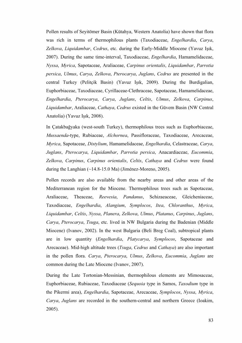
83
Pollen results of Seyitömer Basin (Kütahya, Western Anatolia) have shown that flora
was rich in terms of thermophilous plants (Taxodiaceae, Engelhardia, Carya,
Zelkova, Liquidambar, Cedrus, etc. during the Early-Middle Miocene (Yavuz Işık,
2007). During the same time-interval, Taxodiaceae, Engelhardia, Hamamelidaceae,
Nyssa, Myrica, Sapotaceae, Araliaceae, Carpinus orientalis, Liquidambar, Parrotia
persica, Ulmus, Carya, Zelkova, Pterocarya, Juglans, Cedrus are presented in the
central Turkey (Pelitçik Basin) (Yavuz Işık, 2009). During the Burdigalian,
Euphorbiaceae, Taxodiaceae, Cyrillaceae-Clethraceae, Sapotaceae, Hamamelidaceae,
Engelhardia, Pterocarya, Carya, Juglans, Celtis, Ulmus, Zelkova, Carpinus,
Liquidambar, Araliaceae, Cathaya, Cedrus existed in the Güvem Basin (NW Central
Anatolia) (Yavuz Işık, 2008).
In Çatakbağyaka (west-south Turkey), thermophilous trees such as Euphorbiaceae,
Mussaenda-type, Rubiaceae, Alchornea, Passifloraceae, Taxodiaceae, Arecaceae,
Myrica, Sapotaceae, Distylium, Hamamelidaceae, Engelhardia, Celastraceae, Carya,
Juglans, Pterocarya, Liquidambar, Parrotia persica, Anacardiaceae, Eucommia,
Zelkova, Carpinus, Carpinus orientalis, Celtis, Cathaya and Cedrus were found
during the Langhian (~14.8-15.0 Ma) (Jiménez-Moreno, 2005).
Pollen records are also available from the nearby areas and other areas of the
Mediterranean region for the Miocene. Thermophilous trees such as Sapotaceae,
Araliaceae, Theaceae, Reevesia, Pandanus, Schizaeaceae, Gleicheniaceae,
Taxodiaceae, Engelhardia, Alangium, Symplocos, Itea, Chloranthus, Myrica,
Liquidambar, Celtis, Nyssa, Planera, Zelkova, Ulmus, Platanus, Carpinus, Juglans,
Carya, Pterocarya, Tsuga, etc. lived in NW Bulgaria during the Badenian (Middle
Miocene) (Ivanov, 2002). In the west Bulgaria (Beli Breg Coal), subtropical plants
are in low quantity (Engelhardia, Platycarya, Symplocos, Sapotaceae and
Arecaceae). Mid-high altitude trees (Tsuga, Cedrus and Cathaya) are also important
in the pollen flora. Carya, Pterocarya, Ulmus, Zelkova, Eucommia, Juglans are
common during the Late Miocene (Ivanov, 2007).
During the Late Tortonian-Messinian, thermophilous elements are Mimosaceae,
Euphorbiaceae, Rubiaceae, Taxodiaceae (Sequoia type in Samos, Taxodium type in
the Pikermi area), Engelhardia, Sapotaceae, Arecaceae, Symplocos, Nyssa, Myrica,
Carya, Juglans are recorded in the southern-central and northern Greece (Ioakim,
2005).

84
The main difference with these regions is the high abundance of Taxodiaceae in the
Late Miocene localities in this study. Other differences are abundance of Tsuga (in
Enez and Prosilio) and Cedrus (at İntepe after the MSC). In addition, Cupressaceae
(Juniper family) are more abundant (reaching up to 61%) at Prosilio during this time.
Cupressaceae contain species living in a warm-humid conditions and some others in
dry-cold conditions (Suc and Popescu, 2005; Popescu, 2006).
It is difficult to assess a finer identification than the family level because of the very
poor variability of morphological characters of Cupressaceae. In this situations, their
interpretation is made according to their behavior in the pollen records. Here,
Cupressaceae show a parallel curve to those of mid- and high-altitude elements,
steppes (Artemisia and Hippophae rhamnoides) and herbs. This could indicate
lowering in temperature. Indeed, studies on modern and fossil species of
Cupressaceae (Thuja) show that this taxon can survive under the cold to freezing
conditions (LePage, 2003).
There are studies on macroflora data in Turkey for the Miocene and Pliocene
(Kasaplıgil, 1977; Sakınç, 2007) and neighbouring areas (Kovar-Eder, 2006; Kovar-
Eder, 2008; Velitzelos, 1990). Sakınç (2007) examined silicated trees in Thrace from
Late Miocene-Pliocene age. Within silicated tree assemblages, Podocarpaceae,
Anacardiaceae, Fagaceae, Juglandaceae, Engelhardia, Lauraceae, Fabaceae
Caesalpinoideae, Fabaceae Mimosoideae, Rosaceae Prunoideae (Prunus), Asteraceae
have been observed. These silicated tree assemblages are comparable and convenient
with pollen results from this study. Engelhardia, Fagus, Juglans, Asteraceae are also
recorded in Enez and DSDP Site 380.
Kovar-Eder et al. (2006) reconstructed and mapped the vegetation using macroplant
data from southern Europe (Greece and adjacent areas, Italy, southern France and
Spain) from the Late Miocene to Early Pliocene. The results show that
sclerophyllous oaks developed during the Late Miocene and humid subtropical
conditions dominated in Italy during the Early Pliocene. Southern France and Spain
recorded a decrease in thermophilous plants during that time-interval. Pollen flora for
the Pliocene is dominated by swampy component (with mainly Glyptostrobus), and
an evergreen-deciduous mixed assemblage.

85
Within them, Taxodiaceae (Glyptostrobus) is very abundant and. Glyptostrobus is
almost observed in the most of samples of DSDP core between 702.4 and 319.03 m
depth with changing quantity. A detailed scanning electronic microscope analysis of
pollen grains indicates that Taxodiaceae pollen grains have the same morphology
with Glyptostrobus pensilis (i.e. Glyptostrobus lineatus). The last occurrence of
Glyptostrobus in the Black Sea region was expected during the Late Pliocene to
Early Pleistocene. On contrary, analyses of DSDP Site 380 document its persistence
up to Recent. Glyptostrobus was occupying the deltaic coastal areas. Taxodiaceae
disappeared earlier from the northern Mediterranean region (3.6 Ma), later from the
southern Mediterranean (2.6 Ma), from Italy and Crete (1.3 Ma) and disappeared
from Black Sea and Lake Baikal very recently (Suc et al., 2004; Popescu et al.,
2010) (Fig. 6.1).
Figure 6.1 : Latest records of Taxodiaceae swamps in the Mediterranean region.
Quercus is also abundant in the pollen flora. Alnus is generally seen in most of the
sediments as well as Carpinus orientalis, Zelkova, Abies. Cathaya is not very
frequent and Cedrus and Tsuga are not abundant but they are usually recorded.
Microthermic trees such as Abies and Picea are not frequent. Other thermophilous
trees are Euphorbiaceae, Rubiaceae, Arecaceae, Rutaceae, Avicennia alba,
Engelhardia, Platycarya, Sapotaceae, Juglans, Juglans cf. cathayensis, Pterocarya,
Ulmus, Liquidambar orientalis, Carpinus betulus, Platanus, Nyssa, Carya, and
Zelkova.

86
Avicennia is a mangrove element, it was scarcely recorded in the previous work of
DSDP Site 380 (at 1018.85 and 781.63 m depth; Popescu, 2006). In the pollen
records of this study, Avicennia alba is very rare and has been only observed at
412.53 m depth. Avicennia disappeared from the northern Mediterranean at 14 Ma
(Serravalian), from southern Mediterranean and Sicily at ca. 5.3 Ma (Bessedik, 1985;
Suc and Bessais, 1990), and at ca. 1.6 Ma from the southern Black Sea (Popescu et
al., 2010) (Fig. 6.2). This suggests that tropical trees persisted in Anatolia longer
than in the other regions areas of the Mediterranean region. Among the other flora
components, herbs are dominated by Poaceae, Amaranthaceae-Chenopodiaceae,
Asteraceae Asteroideae, Asteraceae Cichorioideae. Steppe assemblages include
Artemisia, Hippophae rhamnoides and Ephedra. Within them, Artemisia is very
abundant.
Figure 6.2 : Latest records of Avicennia mangrove in the Mediterranean region.
Pinus and Mediterranean xerophytes (Quercus ilex type, Olea, Ligustrum) are not
frequent. Pollen records have similar floristic patterns to the Early Pliocene recorded
at Garraf1 (NW Mediterranean), Susteren 752.72 (Netherlands), Rio Maior F16
(Portugal), Wolka Ligezawska (Poland) (Suc, 1984; Zagwijn, 1960; Diniz, 1984;
Popescu et al., 2010). Kasaplıgil (1977) recorded plant macrofossils (cones, fruits,
seeds, leaves and branches) in Güvem Basin which is located at 125 km from the
Black Sea coastline (NW Central Anatolia). In the Pliocene Güvem macroflora,
Glyptostrobus europoeus is abundant.

87
This situation agrees with the pollen results of DSDP Site 380. Other common
species is Sequoia langsdorfii. Among other species, there are Carpinus miocenica,
Magnolia sprengeri, Menispermum, Myrica banksiaefolia, Persea indica fossilis,
Platanus, Platycarya miocenica, Pterocarya pterocarpa fossilis, Zelkova ungeri,
Liquidambar europaeum, Acer angustilobum, several species of Quercus,
Castanopsis, Ulmus, Alnus, Betula aff. Luminifera, Populus tremula fossilis, Fagus,
Castanea, Castanopsis, Tsuga, Salvinia, Potamogeton, Typha, Pinus, Picea, etc.
Kasaplıgil (1977) also examined pollen grains. Pollen grains include Alnus, Betula,
Menispermum, Pterocarya, Nyssa, Ulmus, Zelkova, Quercus, Salix, Cedrus, Picea,
etc.
In NW Macedonia and Western Greece (Ptolemais Notio, Ptolemais Base, Trilophos
and Lion of Amphipoli), flora is depicted by mesothermic trees (Quercus, Carya,
Pterocarya, Zelkova, Ulmus, Liquidambar, Carpinus orientalis, Juglans, etc.).
Among them, Quercus, Pterocarya, Zelkova, Alnus, Betula are abundant. Tropical
trees are scarcely found. Subtropical plants (i.e. Taxodiaceae, Engelhardia and
Taxodium type) are presented in small amounts. Cathaya is not very important in the
regions except at Lion of Amphipoli.
Cedrus and Tsuga are frequent. Among herbs, Poaceae, Amaranthaceae-
Chenopodiaceae, Asteraceae Asteroideae, Asteraceae Cichorioideae are recorded.
Within them, Poaceae is very abundant in Ptolemais Notio section. Mid- and high-
altitude conifers are represented by Cedrus, Tsuga, Abies and Picea. The previous
palynological studies from the Ptolemais Basin show that the flora is dominated by
Taxodiaceae, Cyperaceae, deciduous Quercus and Poaceae (Kloosterboer-van Hoeve
et al., 2001, 2006). In this study, more taxa have been identified when comparing
with the previous microfloristic studies in the Ptolemais Basin. In addition,
Cyperaceae are not abundant in the samples.
Other differences from previous studies are the abundance of mid- and high-altitude
conifers (Cedrus, Tsuga, Abies and Picea) during the Early Pliocene. This could
display the presence of elevated nearby reliefs. Macroflora (leaves, fruits, seeds)
from the Ptolemais area evidences mixed-mesophytic forest assemblages during the
Pliocene (Velitzelos, 1990). This macrofloristic results are comparable with pollen
data from Ptolemais Notio and Ptolemais Base.

88
Pollen records of the studied areas indicate that prominent changes occurred in the
flora. Results show how Anatolia recorded the floral extinctions. The Neogene
successive coolings began at 14 Ma and resulted in the vanishing of thermophilous
plants in the Northern Hemisphere mid-latitudes. As a consequence, two residual
refuge areas developed in the Mediterranean region. One of them locates in the
Northeastern Medditerranean region as documented by the persisting taxa Zelkova,
Pterocarya, Liquidambar and Cedrus. The other refuge area is in the Southwestern
Mediterranean region. Laurus, Argania (Sapotaceae) and Cedrus are relict plants in
this area (Quézel and Médail, 2003). On the Anatolia coastlines, Pterocarya
fraxinifolia and Liquidambar orientalis are the only thermophilous elements to
persist near slopes of coastal ranges (Fig. 6.3).
Figure 6.3 : Latest records of some thermophilous warm-temperate trees in the Mediterranean region. Dark blue circles indicate refuge areas.
In the pollen records of this study, they have been observed since the Late Miocene.
This makes the study area the most important refuge domain in the region (Zohary,
1973; Quézel and Médail, 2003). Relict plants were well-defined in the pollen
records. They were living in Anatolia during the Pliocene-Pleistocene, during the
Early Pliocene and Latest Miocene. Most of them, such as Carya, Parrotia persica,
Cathaya, Cedrus and Tsuga persisted in the region up today. Their disappearance
seems to have happened during the Middle Pleistocene. Taxodiaceae were still living
on the Rhodes Island 500 kyrs ago (Suc and Popescu, 2005).

89
However, Taxodiaceae disappeared from the Euxinian-Hyrcanian region sub-
recently (Fig. 6.1). The persistence of relict plants in Anatolia could be explained by
the effective influence of the Asiatic monsoon which almost continuously provided
water masses along a longitudinal gradient allowing the maintain of plants requiring
warm and humid climatic conditions despite the successive Quaternary glaciations.
6.2 Vegetation
Observed changes in vegetation according to this study will be described since the
Late Miocene and discussed in this section. Abundance and diversity of identified
pollen grains enable a reliable comparison with the present-day plant ecosystems.
The most crucial parameters controlling the vegetation organization in altitude are
both temperature and precipitation. Therefore, vegetation reconstructed from this
study must be compared with the organization in altitudinal belts of present-day
forest in southeastern China (Wang, 1961) (Fig. 6.4), as it is the closest living
example for the Miocene European flora (Suc, 1984; Axelrod et al., 1996; Jiménez-
Moreno, 2005; Jiménez-Moreno et al., 2005; Jiménez-Moreno, 2006; Jiménez-
Moreno et al., 2007a,b; 2008a,b; Jiménez-Moreno et al., 2010). Thus, the North-
Aegean Late Neogene vegetation could be split into ecologically different
environments:
(1) open lowlands were characterized by open vegetation with steppe
elements such as Poaceae, Amaranthaceae-Chenopodiaceae, Convolvulus
and Ephedra, Artemisia, etc., and both some halophytes such as
Caryophyllaceae, Plumbaginaceae and in some places an aquatic
ecosystem constituted by Potamogeton, Sparganium, Typha, Thalictrum,
Liliaceae, etc.; and the Mediterranean xerophytes such as Quercus ilex
type, Olea, Ligustrum, etc.;
(2) a broad-leaved evergreen forest, from sea level to around 700 m altitude
composed by Glyptostrobus, Rhus, Euphorbiaceae, Rutaceae,
Engelhardia, Sapotaceae, Distylium, Ilex, etc.;
(3) an evergreen and deciduous mixed forest, above 700 m in altitude
characterized by deciduous Quercus, Engelhardia, Taxodium type,
Platycarya, Carya, Pterocarya, Carpinus orientalis, Celtis, Fagus, Acer,
Hedera, Liquidambar cf. orientalis, etc.
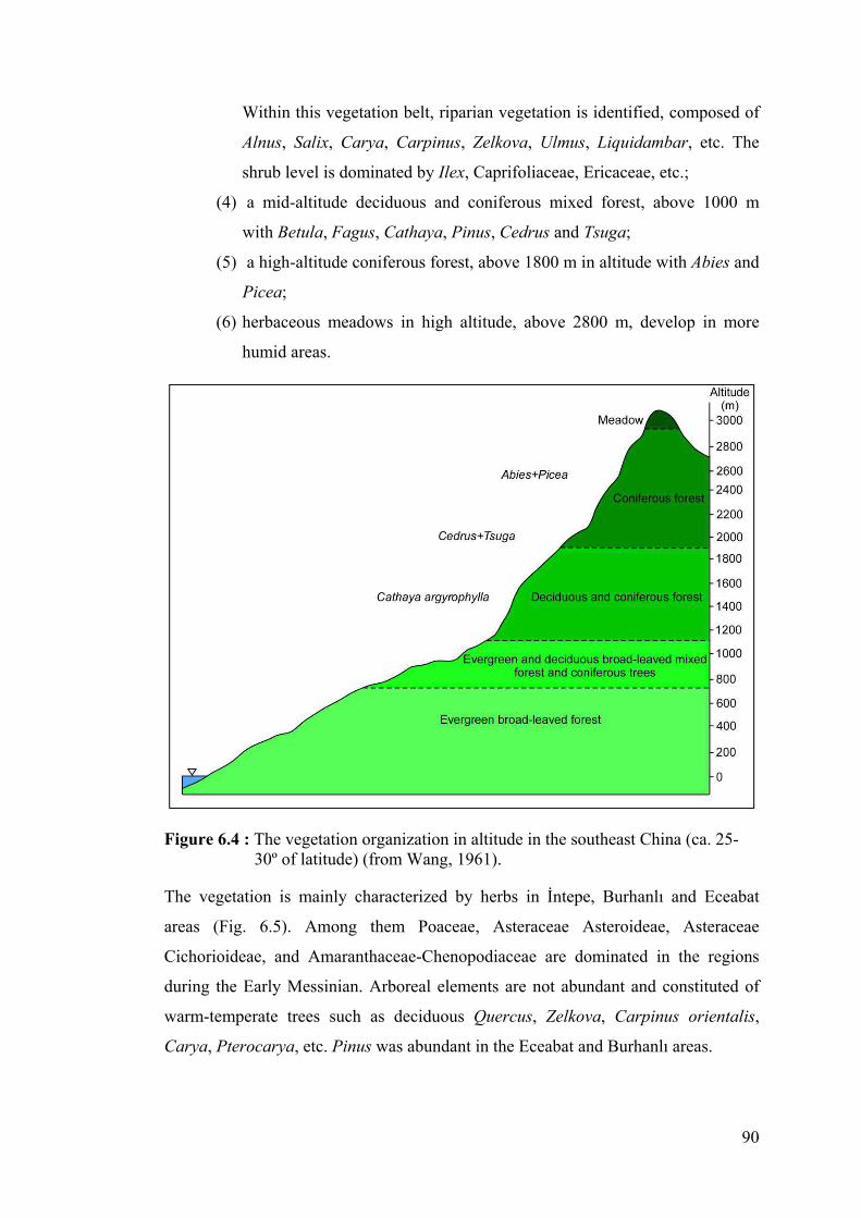
90
Within this vegetation belt, riparian vegetation is identified, composed of
Alnus, Salix, Carya, Carpinus, Zelkova, Ulmus, Liquidambar, etc. The
shrub level is dominated by Ilex, Caprifoliaceae, Ericaceae, etc.;
(4) a mid-altitude deciduous and coniferous mixed forest, above 1000 m
with Betula, Fagus, Cathaya, Pinus, Cedrus and Tsuga;
(5) a high-altitude coniferous forest, above 1800 m in altitude with Abies and
Picea;
(6) herbaceous meadows in high altitude, above 2800 m, develop in more
humid areas.
Figure 6.4 : The vegetation organization in altitude in the southeast China (ca. 25-30º of latitude) (from Wang, 1961).
The vegetation is mainly characterized by herbs in İntepe, Burhanlı and Eceabat
areas (Fig. 6.5). Among them Poaceae, Asteraceae Asteroideae, Asteraceae
Cichorioideae, and Amaranthaceae-Chenopodiaceae are dominated in the regions
during the Early Messinian. Arboreal elements are not abundant and constituted of
warm-temperate trees such as deciduous Quercus, Zelkova, Carpinus orientalis,
Carya, Pterocarya, etc. Pinus was abundant in the Eceabat and Burhanlı areas.

91
The other elements are subtropical trees, mid- and high-altitude trees, mediterranean
xerophytes, steppe elements, non-significant trees and Cupressaceae. They are not
prevalent in the pollen floras from that time. During the Late Miocene, the vegetation
was mainly dominated by altitudinal coniferous trees (mid- and high-altitude
elements) such as chiefly Tsuga, Abies and Picea and Cupressaceae in Prosilio
(northern Greece).
Herbs (Asteraceae Asteroideae, Asteraceae Cichorioideae, Poaceae, Amaranthaceae-
Chenopodiaceae) and steppe elements (Artemisia and Hippophae rhamnoides) are in
small amounts. Also mesothermic trees (Quercus, Ulmus and Alnus) display low
abundance in the pollen floras. Pinus is also abundant. In addition, sediments include
Botryococcus colonies. The presence and abundance of Botryococcus indicate
freshwater input and lake-level fluctuations during that time. Besides, Cupressaceae
is very common in the area. The vegetation is depicted by generally warm-temperate
elements and herbs during the Late Miocene (latest Messinian)-Early Pliocene
(earliest Zanclean) in the region (Enez, İntepe, West Seddülbahir, Ptolemais Notio,
Ptolemais Base, Lion of Amphipoli and Trilophos).
In open vegetation, mainly Poaceae, Asteraceae Asteroideae, Asteraceae
Cichorioideae, and Amaranthaceae-Chenopodiaceae, etc. (with water plants:
Sparganium, Typha, Potamogeton) are found. This agrees with outcomes of the
CARAIB vegetation model (Favre, 2007). Potential vegetation maps constructed
from interpolation of pollen data obtained for most of them before this study confirm
that herbs and mesothermic plants were largely developed in the region during the
Zanclean (Figs. 6.6 and 6.7). An evergreen and deciduous mixed forest was
composed of mesothermic elements such as deciduous Quercus, Carya, Pterocarya,
Fagus, Acer, Carpinus orientalis, Liquidambar orientalis, Ilex, also Engelhardia,
etc. Within this vegetation belt, a riparian vegetation is identified with Salix, Alnus,
Carya, Carpinus orientalis, Zelkova, Ulmus, Liquidambar, etc.
In addition, mid- and high-altitude trees (Cedrus, Tsuga, Abies and Picea) increased
in the region during the Late Miocene-Early Pliocene. This could be caused by some
uplift of the surrounding massifs. Cathaya, a mid-altitude conifer, does not vary
significantly in the region during that time. Mediterranean xerophytes, Cupressaceae
and steppe (Artemisia) elements are in small amounts. Nevertheless, Pinus seems to
be over-represented.

92
During the Late Miocene-Early Pliocene, vegetation on the Southwest Black Sea
shorelines (as illustrated by the DSDP Site 380 pollen content) is characterized by
thermophilous plants and herbs with steppe assemblages. Among thermophilous
trees, subtropical (Taxodiaceae including Taxodium type, Sequoia type, Sciadopitys,
Engelhardia, Myrica, etc.) and warm-temperate trees (i.e., deciduous Quercus,
Carya, Pterocarya, Juglans, Zelkova, Ulmus, etc.) are recorded (Popescu, 2006).
Within herb and steppe elements, Poaceae, Amaranthaceae-Chenopodiaceae and
Artemisia are abundant during that time. The similar vegetation trends were observed
in southwestern Romania during the Early Pliocene where developed swampy
forests competing with herbaceous vegetation (Popescu, 2006). The significant
changes occurred in the vegetation during the Late Pliocene (early Piacenzian)-Early
Pleistocene (Gelasian). The most of the plants were inherited from the Miocene.
Most of the thermophilous plants disappeared from the region in contrast to a
continuous increase in mesothermic trees.
In DSDP Site 380, it is seen that the competition between two vegetation types
prevailed during the studied time-interval, opposing forest assemblages and herbs
with Artemisia steppes. At the end of the Zanclean, herbaceous environments (with
mainly Amaranthaceae-Chenopodiaceae, Poaceae, Asteraceae Asteroideae,
Asteraceae Cichorioideae) dominated in the region with Artemisia steppes. The
percentage of Amaranthaceae-Chenopodiaceae reaches up around 88%. During this
time, subtropical trees were not abundant with mesothermic plants. At the early
Piacenzian, corresponding to Pollen zone 4 (603-460.540 m) (see for detail Popescu
et al., 2010), swamp forests were well developed in contrast to herb landscapes with
steppe elements.
Within swamp forests, Taxodiaceae (mainly probably Glyptostrobus) prevailed with
Engelhardia, Sapotaceae, Nyssa, etc. Deciduous mixed forests mainly composed of
mesothermic elements such as deciduous Quercus, Betula, Alnus, Liquidambar,
Fagus, Carpinus orientalis, Carpinus betulus, Tilia, Acer, Ulmus, Zelkova, Carya,
Pterocarya, etc. were largely developed during this time, but situated at higher
altitude. Within this vegetation belt, riparian forest also developed with Salix, Alnus,
Carya, Carpinus orientalis, Zelkova, Ulmus, Liquidambar, etc.

93
Figure 6.5 : Late Neogene synthetic pollen diagrams in the study region. Numbers show the plants groups in synthetic pollen diagrams: 1, Megathermic elements; 2, Mega-mesothermic elements; 3, Cathaya; 4, Mesothermic elements; 5, Pinus; 6, Meso-microthermic elements; 7, Microthermic elements; 8, Non-significant elements; 9, Cupressaceae; 10, Mediterranean xerophytes; 11, Herbs; 12, Steppe elements.

94
Figure 6.6 : Interpolated vegetation map for herbs during the Zanclean (Favre, 2007).
Figure 6.7 : Interpolated vegetation map for mesothermic trees during the Zanclean (Favre, 2007).
The BIOME4 and paleodata reconstructions indicate that temperate forest dominated
in northeastern Europe during the Middle Pliocene (Salzmann et al., 2008). Herb
assemblages were mainly composed of Amaranthaceae-Chenopodiaceae, Poaceae,
Asteraceae Asteroideae, Asteraceae Cichorioideae, Caryophyllaceae, Brassicaceae,
Polygonum, Rumex, etc.
Steppe elements (i.e., Artemisia, Ephedra, Hippophae rhamnoides) were frequent
during that time. At the beginning of the Pleistocene, glacial-interglacial cycles
occurred with a major decrease in temperature. This caused strong alternations in
vegetation. Glacial-interglacial changes in vegetation are marked by alternations of
Artemisia steppes with herbs and forest assemblages (composed of mesothermic
trees). This situation is well observed in the studied interval of DSDP Site 380.

95
At the Early-Middle Pleistocene (early-middle Gelasian-early Calabrian), herbs are
common with steppes (Artemisia, Ephedra and Hippophae rhamnoides), including
mostly Amaranthaceae-Chenopodiaceae, Poaceae, Asteraceae Asteroideae,
Asteraceae Cichorioideae, Brassicaceae, etc. Mega-mesothermic trees are not
abundant, but mesothermic plants (i.e., mainly deciduous Quercus, Alnus, Betula,
Carpinus orientalis, etc.) show somewhat increasing trends.
Nevertheless, the same vegetation trend is observed in the southern Apennines
(Italy). Here the vegetation is characterized by the competition between steppe taxa
and forest assemblages during the Lower-Middle Pleistocene (Sabato et al., 2005).
The other observed vegetation types through study intervals are altitudinal forests
made of microthermic and meso-microthermic trees, mediterranean xerophytes, non-
significant elements and Cupressaceae.
Microthermic (Abies and Picea) and meso-microthermic (Cedrus and Tsuga)
conifers are not frequent as well as Pinus, mediterranean xerophytes (Olea, Quercus
ilex type, Ligustrum), non-significant elements (Rosaceae and Ranunculaceae) and
Cupressaceae.
6.2.1 The development of Artemisia steppes
Artemisia is the well-known cosmopolitan wind-pollinated sagebrush. Past evidences
of Artemisia steppes have probably existed since the Middle Tertiary from arid or
subarid areas of temperate Asia (Wang et al., 2003; Yunfa et al., 2010).
Development of Artemisia in mid-altitudes of central Asia was strongly encouraged
by uplift of the Tibetan Plateau during the Miocene and the Artemisia development
and expansion is drawn versus the global cooling curve and Tibetan uplift history (in
Fig. 6.8). The Moreover, the other effects on diversification and distribution of
Artemisia are global cooling and Asian monsoon in that area.
The presence of open vegetation without a significant development of Artemisia
steppes in other regions of Mediterranean (i.e., in the southern Mediterranean) is
established since the Earliest Miocene (Suc et al., 1995a, b; Bachiri Taoufiq et al.,
2001; Jiménez-Moreno and Suc, 2007). Pollen results from the studied area enable
information on the earliest development of Artemisia steppes in Anatolia in time and
space.

96
Figure 6.8 : Diagram indicating the origin and development of Artemisia (from Yunfa et al., 2010), with global climate (Zachos et al., 2008), capital letters in the diagram: A, B, C, D are adapted from Li, 1991; Li and Fang, 1999; An et al., 2006; Rowley and Currie, 2006; d. Wan et al., 2007) and the Asian monsoon intensity (Wan et al., 2007).
The occurrence of Artemisia in Anatolia could be divided into three parts as the
Miocene, Pliocene and Pleistocene. The earliest records of Artemisia steppes in
Anatolia concern the Early Miocene (Aquitanian~23.0-20.4 Ma) from the central
Taurus, more precisely the Ermenek region (Biltekin, unpublished). In this area,
Artemisia is observed in almost all the samples and reaches up to around 10%.
In addition, Artemisia steppes were found in Çatakbağyaka (southwestern Aegean
region) during the Middle Miocene (Langhian) (Jiménez-Moreno, 2005). Also
Artemisia was found in western Anatolia (Seyitömer Basin, Kütahya) at the Late
Early-Middle Miocene (Yavuz Işık, 2007).

97
In other parts of the world, it was common in the western part of the Tibetan Plateau
during the Miocene (Yunfa et al., 2010) and in the Snake River Plain (America)
during the Miocene (~12 Ma) (Davis and Ellis, 2010), in the western north America
at the Early Miocene, in the Northeastern America at the Middle Miocene and in the
central Europe during the Late Oligocene (Graham, 1996).
The main development of the Artemisia steppes with open herbaceous vegetation in
Anatolia began during the Late Miocene-Early Pliocene (Zanclean) and in the Ponto-
Euxinian region during the earliest glacial phases. In the other studied regions i.e.,
Eceabat, Burhanlı, İntepe, Artemisia is present but in very small amounts.
The marked changes occurred between the Miocene and the Pliocene. Because of
this, high resolution pollen records of the Black Sea DSDP Site 380 are very
informative about the development of Artemisia steppes in Anatolia (Fig. 6.9). In the
studied intervals, the increase of Artemisia continued through the Pliocene.
It reached up to approximately 62% during the Pliocene. When the glacial-
interglacial cycles began at the beginning of the Pleistocene, Artemisia was very
abundant. The abundance of Artemisia steppes have continued along the whole
Pleistocene until present. Maximum abundance of Artemisia occurred at 401.44 m in
DSDP Site 380. In this depth, Artemisia reaches up about 85%.
According to the pollen results, the earliest settlement of sagebrush (Artemisia)
steppes seems to be extended to the Early Miocene (Auqitanian) in the central Taurus
(Biltekin, unpublished). Overall the development of Artemisia in Anatolia could
result from the combined effects of uplift of the Tibetan Plateau, onset of global
cooling and reinforcement of the Asian monsoon (Zhisheng et al., 2001, Yunfa et al.,
2010).

98
Figure 6.9 : Chronological distribution of Artemisia steppes since the Early Miocene until today in the studied region.

99
6.3 Climate
6.3.1 Global climate context during the Miocene and Pliocene
Neogene climate constitutes the transition from greenhouse conditions of Paleogene
to the icehouse conditions of Quaternary. East Antartic Ice Sheet (EAIS) expanded at
the beginning of the Neogene (Pagani et al., 1999; Zachos et al., 2001) (Fig. 6.10).
This situation is well-documented at worldwide-scale with decrease in temperature
and positive oxygen isotope incursion (Miller et al., 1991; Zachos et al., 2001). The
benthic foraminiferal oxygen isotope values give the evidence for at least nine glacial
events during the Miocene, four of them occurred during the Early Miocene (Miller
et al., 1991; Pagani et al., 1999).
Until the Middle Miocene (~15 Ma) global ice volume stayed low (with slightly
bottom water temperatures) with several brief glaciations (i.e., Mi-events) (Zachos et
al., 2001). The low CO2 values are in correspondence with major glaciations
(Kürschner et al., 2008). At the Late-Middle Miocene (Upper Burdigalian-Lower
Langhian, ~17-15 Ma) a warm phase occurred known as the Miocene Climatic
Optimum (Zachos et al., 2001, 2008) (in Fig. 6.10). During this warm phase, CO2
concentrations were 500 ppmv (Kürschner et al., 2008). After this warm period, the
Monterey cooling event occurred at 14 Ma ago. This event coincides with ice sheet
expansion in Antarctica (Flower and Kennett, 1993, 1994; Miller et al., 1991; Zachos
et al., 2001).
During the early Late Miocene, low-mid altitude surface waters of world oceans
warmed up. This global climate variability was induced by two events: the closure of
the Indonesian Seaway at 8-5.2 Ma and the onset of the Tibetan Plateau uplift
(Zhisheng et al., 2001; Zhang et al., 2009; Yunfa et al., 2010). During the Late
Miocene (Tortonian), high seasonality existed in the Eastern Mediterranean (Eronen
et al., 2009). Summer drought increased from Tortonian to the Messinian. High
evaporation and low rainfall occurred with lower seasonality due to the increased
duration of summer aridity in the Eastern Mediterranean during the Messinian
(Eronen et al., 2009).

100
Figure 6.10 : Global deep-sea oxygen records with main events (taken from Zachos et al., 2001).
The Pliocene constitutes the transition from relatively warm episodes to the cooler
climates of the Pleistocene (Suc, 1984; Dowsett and Poore 1991; Lisiecki and Raymo
2007; Haywood et al., 2009). The Pliocene epoch could be split into three phases: (1)
the Early Pliocene warm period including three inner subdivisions, (2) a relatively
short-lived ‘warm interval’ at ca. 3 Ma, known as the mid-Pliocene warm interval
and (3) a climatic deterioration during the Late Pliocene leading to the high-
magnitude climate variability associated with glacial/interglacial cycles of
Pleistocene.
Although a progressive cooling existed during the Tertiary, the Pliocene seems to
have been warmer than today (Jansen et al. 2007). The Early Pliocene was an
interval of global warmth characterized by high CO2 levels (Van der Burgh et al.,
1993; Raymo et al., 1996; Kuerschner et al., 1996; Billups et al., 2008) and warm
sea-surface temperatures (in upwelling regions and at high latitudes) (e.g., Dowsett et
al., 1992; Herbert and Schuffert, 1998; Dowsett et al., 2005;Wara et al., 2005;
Lawrence et al., 2006; Ravelo et al., 2007). During the middle Pliocene (~3 Ma), the
paleontological data, sea level, vegetation, land-ice distribution, sea-ice distribution
and sea surface temperatures (SST) were reconstructed.

101
Figure 6.11 : Distribution of modern and mid-Pliocene land and sea ice in the Northern Hemisphere (from Dowsett et al., 1994).
Figure 6.12 : Distribution of modern and mid-Pliocene land and sea ice in the Southern Hemisphere (from Dowsett et al., 1994).

102
The middle Pliocene sea level was at least 25 m higher than present because of the
reduction in size of the East Antarctic Ice Sheet (Dowsett et al., 1994). The Pliocene
winter reconstructions (Dowsett et al., 1994) indicate that sea ice covered the north
coast of Siberia and Greenland in the Northern Hemisphere, regions which are today
completely covered by ice during the winter (Fig. 6.11). In the Southern Hemisphere,
sea ice was then in the Weddell Sea, the coast of the Queen Maun Land, Wilkes
Land and Marie Byrd Land (Fig. 6.12) (Dowsett et al., 1994).
At the end of the Pliocene, with the onset of major Northern Hemisphere glaciations
at approximately 2.6 Ma, climate got cooler and glacial–interglacial cycles appeared
in the Northern Hemisphere (Lisiecki and Raymo, 2007). The mid-Pleistocene
transition (MPT) was a crucial event when the dominant periodicity of glacial
response changed from 41 to 100 kyrs. The ‘‘saw-tooth’’ asymmetry of glacial
cycles first appears shortly after the onset of major Northern Hemisphere Glaciations
and duration of interglacial phases decreased at 1.4 Ma (Lisiecki and Raymo, 2007).
6.3.2 Climatic evolution of the studied areas
Results of pollen data provide a climate synthesis of the studied areas during the Late
Miocene-Early Pleistocene. Before the Messsinian Salinity Crisis, at the early
Messinian, abundance of mega-mesothermic and mesothermic trees in the Ponto-
Euxinian region indicate that subtropical, i.e. warm climate conditions, existed
during that time in the region (Popescu, 2006).
Climate also was humid according to the existence of thermophilous elements which
require very humid conditions during all the year (Wang, 1961). In the Northern
Aegean area, in the İntepe, Burhanlı and Eceabat regions (Melinte et al., 2009), the
high abundance of open vegetation elements (Poaceae, Asteraceae Asteroideae,
Asteraceae Cichorioideae, and Amaranthaceae-Chenopodiaceae, etc.) indicate drier
climate conditions.
However, abundance of mesothermic trees (deciduous Quercus, Carya, Zelkova,
etc.) with few subtropical taxa (Taxodiaceae, Engelhardia) also suggests a coastal
freshwater marsh (Fig. 6.13). At the Late Miocene (before the MSC), Prosilio pollen
flora shows that the presence and high abundance of mid- (mainly Tsuga) and high-
altitude (Abies and Picea) conifers and high abundance of Cupressaceae in the
northern Greece during this time-interval.

103
The existence of mid- and high-altitude trees with Cupressaceae suggests that some
elevated massifs existed in the region with a cool-temperate climate. During the Late
Miocene (latest Messinian)-Early Pliocene (earliest Zanclean), after the MSC, in
Enez, West Seddülbahir, İntepe, Ptolemais Notio, Ptolemais Base, Lion of
Amphipoli and Trilophos, the vegetation mainly characterized by herbs (Poaceae,
Asteraceae Asteroideae, Asteraceae Cichorioideae, and Amaranthaceae-
Chenopodiaceae, etc.) while forest assemblages were composed of mesothermic
elements such as deciduous Quercus, Carya, Zelkova, etc. (in Fig. 6.13). This points
out warm and dry climate conditions at low altitude in the region.
The studies based on CO2 trend during the Miocene indicates that the presence of C4
plants (grasslands) at the Middle-Late Miocene (Kürschner et al., 2008). Another
significant change observed in the pollen floras is the increase in conifer (mainly
Cedrus, Abies and Picea) (Melinte et al., 2009). Calculation of the mean annual
temperature based on pollen records have been performed using the “climatic
amplitude” transfer function (Fauquette et al., 1998). For İntepe samples 22-26,
calculated mean annual temperature is 16.5ºC (range: 15-18ºC) (Melinte et al.,
2009). The same trend, i.e. the increase in conifers, is also observed in areas
(Ptolemais Notio, Ptolemais Base, Lion of Amphipoli and Trilophos). This could be
caused by some uplift of the massifs of the region as considered in the İntepe region.
During the Late Miocene-Early-middle Pliocene, after the MSC, mega-mesothermic
and mesothermic elements were abundant in the Ponto-Euxinian region, in contrast
to herbs with some development of Artemisia steppes during cooler phases of Pollen
zone 1 (Popescu, 2006; Popescu et al., 2010). Warm and humid climate existed in
the region during interglacials. While mesothermic plants increased during the Late
Miocene-Early Pliocene, the impoverishment in thermophilous trees since the
Miocene is regarded as the result of a continuous and progressive decrease in
temperature since 14 Ma (Zachos et al., 2001; Darby, 2008). During the Middle-Late
Zanclean, according to pollen record from DSDP Site 380, the vegetation was
characterized by dominant herbs with weakly developed Artemisia steppes.
Subtropical trees are not abundant. Mesothermic trees are frequent. Cupressaceae
and Cathaya were rare during that time which corresponds to Pollen zone 2 (702.80-
624 m) of Popescu et al. (2010).

104
Figure 6.13 : Synthetic pollen diagrams of the studied localities. DSDP Site 380: S. Boroi, D. Biltekin and S.-M. Popescu, Grouping of plants follows Suc (1984): 1, Megathermic elements; 2, Mega-mesothermic elements; 3, Cathaya; 4, Mesothermic elements; 5, Pinus; 6, Meso-microthermic elements; 7, Microthermic elements; 8, Non-significant elements; 9, Cupressaceae; 10, Mediterranean xerophytes; 11, Herbs; 12, Steppe elements. The reference oxygen isotope curve is from Shackleton et al. (1990, 1995).
105
During that time climate was not very dry but cooler conditions existed. At the Latest
Zanclean, vegetation is depicted by herbs with higher amounts of Artemisia. Mega-
mesothermic and mesothermic trees are then not very important. The high presence
of herbs and Artemisia steppes during this time suggests that climate was cooler and
drier. Swamp forests (with Glyptostrobus, Engelhardia, Sapotaceae, Nyssa) seriously
reduced at ca. 3.4 Ma but persisted during the Piacenzian (Late Pliocene) in contrast
to significantly extending herbs with Artemisia steppes. Reduced deciduous mixed
forests with mesothermic trees (deciduous Quercus, Betula, Alnus, Liquidambar,
Fagus, Carpinus orientalis, Carpinus betulus, Tilia, Acer, Ulmus, Zelkova, Carya,
Pterocarya) persisted too.
During this time, herbs composed of Amaranthaceae-Chenopodiaceae, Poaceae,
Asteraceae Asteroideae, Asteraceae Cichorioideae, Caryophyllaceae, Brassicaceae,
Polygonum, Rumex, etc. strongly strengthened. However, steppe elements are low
during that time. This documents that cooler and drier climatic conditions existed
since 3.4 Ma. There is some starting competition between moister-warmer phases to
cooler-drier ones announcing the forthcoming interglacial-glacial phases. At ~3 Ma,
paleoclimatic studies show that a warm event existed (Draut et al., 2003).
Climate was warmer than today in the Artic regions of North America, Iceland,
Russia and western-central Europe (Dowsett et al., 1994). In addition, diatom
studies in the deep sea cores (DSDP 266, ODP 699A, ODP 747A and Eltanin Core
50-28) Southern Ocean also support that climate was warmer during that time,
summer surface temperatures are more than 3-4ºC warmer than present at latitudes
between 55º and 60ºS (Barron, 1996). This warmer period is also documented by
pollen data of DSDP Site 380.
During this time, forest communities were somewhat more developed, especially
represented by mega-mesothermic trees such as mainly Taxodiaceae, in contrast to
lower representation of herbs and steppe elements. Results of the GISS General
Circulation Model (GCM) indicate the following temperatures in southern Europe:
6ºC warmer over the Iberian Peninsula, 2-4ºC warmer over the rest of southern
Europe. Precipitation and winter soil moisture were close to modern levels (Chandler
et al., 1994). At the beginning of Pleistocene (~2.6 Ma), when climate got cooler,
glacial-interglacial cycles turned into a strong and rapid competition between forests
and open vegetations.

106
At the earliest Gelasian (Early Pleistocene), mega-mesothermic elements continued
to rarefy. Nevertheless within them, Taxodiaceae (probably Glyptostrobus),
Engelhardia, Sapotaceae, and Nyssa survived. Mesothermic elements composed of
deciduous Quercus, Betula, Alnus, Liquidambar, Fagus, Carpinus orientalis,
Carpinus betulus, Tilia, Acer, Ulmus, Zelkova, Carya, Pterocarya, etc. also almost
disappeared. Herb phases were long with a prevalence of glacials over interglacials.
During the Earliest Ioanian (~1.8 Ma), mega-mesothermic elements were in lower
amounts (except several short peaks in the diagram). From time to time, mesothermic
trees were abundant despite a longer and intense development of herbs with high
Artemisia at the end of the interval. This demonstrates shorter and warmer
interglacials in opposition with longer, colder and drier glacials. In the Early-Middle
Ioanian, thermophilous forest elements enlarged again with strong repeated
fluctuations between forest and open environments. After this time, herbs (with
Artemisia steppes) have continued to increase up to the present-day.

107
7. CONCLUSIONS
This study has been carried out on 11 sections (in the Black Sea: DSDP 380 Site; in
Thrace: Enez; in the Northern Aegean: İntepe, Seddülbahir, Burhanlı, Eceabat; in
Macedonia: Ptolemais Notio and Ptolemais Base, in Greece: Prosilio, Lion of
Amphipoli, and Trilophos). Most of the sections are well-dated by nannofossils.
Pollen grains are generally well preserved in these sediments. Totally, 436 samples
have been analysed, 378 of these samples (Early Pliocene-Early Plesitocene) are
from the Site 380 borehole and the remaining 58 samples come from outcrops in the
other areas. In this study, 107 different taxa have been identified representative of
various ecological environments. Pollen floras from these localities are rich and
diversified and taxa have been arranged from the temperature requirement viewpoint
according to Nix’s classification (1982):
(1) megathermic elements (tropical): Avicennia alba, Euphorbiaceae, Rubiaceae
and Rutaceae;
(2) mega-mesothermic elements (subtropical): Taxodiaceae including Taxodium-
type, Engelhardia, Platycarya, Sapotaceae, Distylium, Microtropis fallax,
Ginkgo, Loropetalum, Arecaceae and Cathaya;
(3) mesothermic elements (warm-temperate): Carpinus orientalis, Juglans,
Juglans cf. cathayensis, Carya, Pterocarya, Liquidambar orientalis,
Platanus, Nyssa, Ulmus, Zelkova, Celtis and Eucommia;
(4) meso-microthermic elements (cool-temperate): Cedrus and Tsuga. (5) microthermic elements (boreal): Abies and Picea.
Nevertheless, an important factor could be as today the altitude which controls
temperature and precipitation. Hence, vegetation should be organized in altitudinal
belts after comparison with the current plant ecosystems (see Discussion chapter).
Pollen records of the studied localities indicate changes in vegetation and climate in
time and space. The vegetation is depicted mainly by herbs in İntepe, Burhanlı and
Eceabat during the Early Messinian.
108
Before the Messinian Salinity Crisis (MSC), trees are relatively abundant in the
İntepe area and mainly composed of mesothermic elements (deciduous Quercus,
Carya, Zelkova, etc.) while vegetation is dominated by herbs (Poaceae, Asteraceae
Asteroideae, Amaranthaceae-Chenopodiaceae, Caryophyllaceae, etc.) with
Artemisia.
At the Late Miocene, mid- (mainly Tsuga) and hig-altitude (Abies and Picea)
coniferous trees were abundant in Prosilio (Northern Greece). Another significant
result in the pollen spectra of Prosilio is the abundance of Cupressaceae, the curve of
which is consistent with those of mid- and high-altitude trees. This suggests that
cooler climate existed in the region. Moreover, the abundance of altitudinal conifers
displays that some uplift of the surrounding massifs occurred before that time.
Just after the MSC, at the Latest Messinian-Earliest Zanclean, herbs are still
abundant in İntepe, Enez, West Seddülbahir, Trilophos, Lion of Amphipoli,
Ptolemais Notio and Ptolemais Base (Poaceae, Amaranthaceae-Chenopodiaceae,
Asteraceae, etc.). Among arboreal trees, mesothermic elements are common at this
time. Within subtropical trees, Ginkgo is recorded at Enez. Today, Ginkgo biloba is
the only species of Ginkgoaceae, living in China. The other prominent result is a
significant increase in altitudinal trees (Cedrus, Tsuga, Abies and Picea) which
denotes some uplift in the Dardanelles area during the MSC.
Vegetation and climate of the Pliocene time is accurately documented by the high-
resolution pollen record from DSDP Site 380 (SW Black Sea) characterized by
various plant assemblages. Most of them were inherited from the Miocene. Several
megathermic (tropical) trees suffered because of the progressive decrease in
temperature since 14 Ma. Within megathermic (tropical) elements, it is appreciable
to mention the last evidence for the Mediterranean region s.l. of Avicennia alba, a
mangrove tree, in the Early Pleistocene from DSDP Site 380, at about 1.6 Ma.
As several records of Avicennia are known from the underlying sediments of DSDP
Site 380, one may postulate that a residual Avicennia mangrove persisted on the
coastal areas in the Ponto-Euxinian region. On the whole, according to Site 380
pollen record, it is established that a strong competition between arboreal trees and
herbs with Artemisia steppes started in the Black Sea region at the Earliest Pliocene
which became more pronounced after 2.6 Ma.

109
During the Early Pliocene (at the end of the Zanclean), herbs composed of mainly
Amaranthaceae-Chenopodiaceae, Poaceae, Asteraceae Asteroideae, Asteraceae
Cichorioideae developed with Artemisia steppes. During this time, Amaranthaceae-
Chenopodiaceae reaches up ca. 88%. In addition, subtropical trees were not as
abundant as mesothermic plants. This suggets cooler and probably drier climatic
conditions in the region.
Swamp forests (with Glyptostrobus, Engelhardia, Sapotaceae, Nyssa) persisted
during the Piacenzian (Late Pliocene) in contrast to extending herbs with Artemisia
steppes. Reduced deciduous mixed forests with mesothermic trees (deciduous
Quercus, Betula, Alnus, Liquidambar, Fagus, Carpinus orientalis, Carpinus betulus,
Tilia, Acer, Ulmus, Zelkova, Carya, Pterocarya) persisted too. During this time,
vegetation was depicted by herbs such as mainly Amaranthaceae-Chenopodiaceae,
Poaceae, Asteraceae Asteroideae, Asteraceae Cichorioideae, Caryophyllaceae,
Brassicaceae, Polygonum, Rumex, etc., containing some aquatic plants e.g.,
Sparganium, Potamogeton, Typha, etc. Steppe elements are composed of Artemisia,
Ephedra, Hippophae rhamnoides). They are in small amounts during that time. This
indicates that cooler and drier climatic conditions existed.
At the Earliest Gelasian (Early Pleistocene), mega-mesothermic elements strongly
rarefied. Among them, Taxodiaceae (probably Glyptostrobus), Engelhardia,
Sapotaceae, and Nyssa persisted. Deciduous mixed forest assemblages composed of
mesothermic trees (warm-temperate) such as Betula, Fagus, Tilia, Acer, Ulmus,
Carya, etc. almost disappeared too. Within this vegetation belt, a riparian forest also
perpetuated with Salix, Alnus, Carya, Carpinus orientalis, Zelkova, Ulmus,
Liquidambar, etc.
Very weak fluctuations are recorded opposing thermophilous trees and the higly
dominant herbs. Herb phases were long with a prevalence of glacials over
interglacials. During the Earliest Ioanian (Middle Pleistocene), vegetation is
characterized by mega-mesothermic elements with low amounts (except some peaks
in the diagram), high amounts of mesothermic trees and longer temporal
development of herbs with high Artemisia at the end of the interval. This
demonstrates shorter and warmer interglacials in opposition with longer, colder and
drier glacials.
110
At the Early-Middle Ioanian (394.50-302.40 m), is observed an increase in
thermophilous forest elements with strong repeated fluctuations between forest and
open (with higher Artemisia steppes) environments. This indicates prominent
climatic fluctuations between interglacials and glacials. After this period, herbs
mostly Amaranthaceae-Chenopodiaceae, Poaceae, Asteraceae Asteroideae,
Asteraceae Cichorioideae, Brassicaceae, etc., with Artemisia steppes (with other
steppe elements: Ephedra and Hippophae rhamnoides) have continued to incrase
until today.
An outstanding result is the development of Artemisia steppes in Anatolia. The
earliest settlement of Artemisia steppes in Anatolia have reached to the Early
Miocene (Aquitanian~23.0-20.4 Ma) in the Ermenek region, central Taurus
(Biltekin, unpublished). Artemisia is common in this region during the Early
Miocene (ca. 10%). The noticeable change is located between the Miocene and the
Pliocene. The high-resolution pollen record of DSDP Site 380 clearly documents the
development of Artemisia steppes in Anatolia. The main development of Artemisia
with non-boreal (herbaceous) vegetation in Anatolia started during the Early
Pliocene in the Ponto-Euxinian region. Indeed, at Eceabat, Burhanlı and İntepe
localities, Artemisia is found in small amounts. The increase of Artemisia continued
through the Pliocene (reaching up about 62%).
At the begining of the Pleistocene (~2.6 Ma), with the start of the glacial-interglacial
cycles, Artemisia steppes continued to develop through the Pleistocene until today.
The development of Artemisia in Anatolia could both relate with the uplifting of the
Tibetan Plateau, global cooling and reinforcement of the Asian monsoon.
At last, thermophilous elements such as Pterocarya and Liquidambar have persisted
on coastal slopes of Anatolia. They have been observed in the pollen floras since the
Early Miocene (Aquitanian). Some others, such as Carya, Parrotia persica, Cathaya
and Tsuga persisted in the region. Their disappearance seems to have happened
during the Middle Pleistocene. However, Taxodiaceae disappeared from the
Euxinian-Hyrcanian region sub-recently. The persistence of relict plants in Anatolia
can be explained by the significant influence of the Asian monsoon which takes
place along a longitudinal gradient. This brought about the preservation of relict
plants in Anatolia.

111
REFERENCES
Adams, C. C., Benson, R. H., Kidd, R. B., Ryan, W. B. F. and Wright, R. C., 1977. The Messinian salinity crisis and evidence of Late Miocene eustatic changes in the world ocean. Nature, 269, 383–6.
Aguirre, J., 1998. El Plioceno del SE de la Península Ibérica (provincia de Almería). Síntesis estratigráfica, sedimentaria, bioestratigráfica y paleogeográfica. Revista de la Sociedad Geológica de España 11, pp. 297–315.
Akcar, N and Schlüchter, C., 2005. Paleoglaciations in Anatolia: A schematic review and first results, Eiszeitalter und Gegenwart 55, 102-121, 8 Abb., Hannover.
Akgün, F., Akyol, E., 1999. Palynostratigraphy of the coal-bearing Neogene deposits graben in Büyük Menderes Western Anatolia. Geobios, 32, 3, 367–383.
Akman, Y., Ketenoğlu, O., 1986. The climate and vegetation of Turkey. In “Plant Life of SW Asia”, Proceedings of the Royal Society of Edimbourgh, Section B, 113- 122.
Akman, Y., Quézel, P., Ketenoğlu, O., Kurt, F., 1993. Analyse syntaxonomique des forêts de Liquidambar orientalis en Turquie. Ecologia
Mediterranea, 19, 49–57.
Akman, Y., and Quézel, P., 1996. La steppe centro-anatolienne: interpretation phytoécologique. Actes des 7èmes Rencontres de l’A.R.P.E. Provence Alpes-Côte d’Azur. Colloque scientifique international Bio’Mes, Digne, 127–131.
Aksu, A. E., Hiscott, R. N. and Yafiar, D., 1999. Oscillating Quaternary water levels of the Marmara Sea and vigorous outflow into the Aegean Sea from the Marmara Sea-Black Sea drainage corridor. Marine Geology 153, 275–302.
Aldanmaz E., 2002. Mantle source characteristics of alkali basalts and basanites in an extensional intracontinental plate setting, western Anatolia, Turkey: Implications for multi-stage melting. Int. Geol. Rev., 44:440-457.
Amigues, S., 2007. Le styrax et ses usages antiques. Journal des Savants, Juillet-Décembre, 2, 263–318.
An, Z. S., Song, Y. G., Zhang, P. Z., Wang, E. Q., Wang, S. M., Qiang, X. K., Li, L., Chang, H., Liu, X. D., Zhou, W. J., Liu, W. G., Cao, J. J., Li, X. Q., Shen, J., Liu, Y., Ai, L., 2006. Changes of the monsoon-arid environment in China and growth of the Tibetan Plateau since the Miocene. Quaternary Science 26(5), 678–693.

112
Armijo, R., Meyer, B., Hubert, A., Barka, A., 1999. Westward propagation of the North Anatolian fault into the northernAegean: timing and kinematics. Geology 27, 267–270.
Axelrod, D. I., Al-Shehbaz, I., Raven, P., 1996. History of the modern flora of China. In: Zhang, Aoluo, Wu, Sugong (Eds.), Floristic Characteristics and Diversity of East Asian Plants. InSpringer-Verlag, Berlin, pp. 43–55.
Bachiri Taoufiq, N., 2000. Les environnements marins et continentaux du corridor rifain au Miocène supérieur d’après la palynologie. Thesis, Univ. Casablanca, 206 p.
Bachiri Taoufiq, N., Barhoun, N., Suc, J.-P., Méon, H., Elaouad, Z., Benbouziane, A., 2001. Environnement, végétation et climat du Messinien au Maroc. Paleontologia I Evolució, 32-33, 127-138.
Barka, A. and Hancock, P. L., 1984. Neotectonic deformation patterns in the convex-northward arc of the North Anatolian fault zone: Dixon, J. E, and Robertson, A.H.F., eds. The Geological Evolution of the Eastern
Mediterranean. Geological Society of London, Special Publication, 17, 285-296.
Barka, A., 1985. Kuzey Anadolu Fay Zonundaki bazı Neojen-Kuvaterner havzaların jeolojisi ve tektonik evrimi. Ketin Sempozyumu Kitabı, 209-227.
Barka, A. A., 1992. The North Anatolian fault Zone. Ann. Tectonicae, 6, 164-195.
Barron, J. A., 1996. Diatom constraints on the position of the Antarctic Polar Front in the middle part of the Pliocene. Marine Micropaleontology 27 (1996) 195-213.
Batten, D. J., and Grenfell, H. R., 1996. Botryococcus. In Jansonius, J., and McGregori, D.C. (Eds), Palynology: principles and applications. Am. Assoc. Stratigr. Palynol. Found., 1:205–214.
Beaudouin, C., 2003. Effets du dernier cycle climatique sur la vegetation vall Rhône et sur a sédimentation de la plate-forme du golfe du Lion d’après la palynologie. PhD thesis, Université Claude Bernard Lyon-1, France, 403 p.
Benda, L., 1971. Grundzüge einer pollenanalytischen Gliederung des Türkischen Jungtertiärs. Beihefte zum Geologischen Jahrbuch, 113, 1–45.
Benson, W. E., Sheridan, R. E., and Shipboard Scientific Party, 1978. Site 391. Blake-Bahama Basin. In Benson, W. E., Sheridan, R. E., et al., Init.
Repts. DSDP, 44: Washington (U.S. Govt. Printing Office), 153-336.
Bertini, A., Corradini, D., Suc, J.-P., 1995. On Galeacysta etrusca and the connections between the Mediterranean and the Paratethys. Rom. J.
Stratigr. 76 (suppl. 7), 141–142.
Bertini, A., 2002. Palynological evidence of Upper Neogene environments in Italy. Acta Univ. Carolinae, Geol., 46(4), 15-25.
Bessedik M., 1985. Reconstitution des environnements miocènes des régions nord-ouest méditerranéennes à partir de la palynologie. Thèse, Univ. Montpellier 2, 162 p.

113
Billups, K., Kelly, C. and Pierce, E., 2008. The late Miocene to early Pliocene climate transition in the Southern Ocean. Palaeogeography, Palaeoclimatology, Palaeoecology 267 (2008) 31–40.
Bornovas, J., Tsiambaou, Th., 1983. Geological map of Greece. Institute of geology and mineral exploration 1:500.000 scale.
Bottema, S., 1986. Late Quaternary and modern distribution of forest and some taxa in Turkey. Proceedings of the Royal Society of Edinburgh, 89B, 103–111.
Boydak, M., 2006. Biology and silviculture of Turkish Red Pine (Pinus brutia Ten.). Lazer Ofset Matbaa Tesisleri San, Ankara, 253 p.
Browicz, K., 1982-1994. Chorology of Trees and Shrubs in the S-W Asia and adjacent regions. Polish Academy of Sciences, Institute of Dendrology, 10 volumes.
Bukry, D., 1973. Low Latitude Coccolith Biostratigraphic Zonation. In: Edgar, N.T., Saunders, J.B., et al. (Eds.), Initial Reports DSDP, vol. 15. US Govt. Printing Office, Washington, pp. 685 703.
Cambon, G., Suc, J.-P., Aloisic, J.-C., Giressec, P., Monacoc, A., Touzanic, A., Duzera, D., Ferriera, J., 1997. Modern pollen deposition in the Rhône delta area (lagoon and marine sediments) France. Grana, 36, 105-113.
Chandler, M., Rind, D. and Thompson, R., 1994. Joint investigations of the Middle Pliocene climate II: GISS GCM Northern Hemisphere results. Glob. Planet. Change 9, 197–219.
Chikhi, H., 1992. Une palynoflore méditerranéenne à subtropicale au Messinien préévaporitique en Algérie. Géol. Médit. 19 (1), 19-30.
CIESM, 2007. The Messinian Salinity Crisis from mega-deposits to microbiology-Consensus Report. CIESM Workshop Monographs, Almeria, 7-10 November, 2007.
Cita, M. B.,Wright, R. C., Ryan,W. B. F., Longinelli, A., 1978. Messinian palaeoenvironments. In: Hsu, K.J., Montadert, L. (Eds.), Initial
Reports of the Deep Sea Drilling Project, vol. 42 part 1. US Government Printing Office, Washington, pp. 1003–1035.
Cita, M. B. and Colombo, L., 1979. Sedimentation in the latest Messinian at Capo Rossello (Sicily). Sedimentology 26, 497–522.
Clauzon, G., Suc, J.-P., Gautier, F., Berger, A., Loutre, M.-F., 1996. Alternate interpretation of the Messinian salinity crisis: Controversy resolved? Geology 24 (4), 363-366.
Clauzon, G., Rubino, J.-L., Casero, P., 2001. Regional modalities of the Messinian salinity crisis in the framework of a two phases model. Late Miocene to Early Pliocene environments and ecosystems. 2nd EEDEN
Workshop. Sabadell, Spain, pp. 17–18.

114
Clauzon, G., Suc, J.-P., Popescu, S.-M., Marunteanu, M., Rubino, J.-L., Marinescu, F. and Melinte, M. C., 2005. Influence of the Mediterranean sea-level changes over the Dacic Basin (Eastern Paratethys) in the Late Neogene. The Mediterranean Lago Mare facies deciphered. Basin Research, 17 : 437-562.
Clauzon, G., Suc, J.-P., Popescu, S.-M., Melinte, M. C., Quillévéré, F., Warny, S. A., Fauquette, S., Armijo, R., Meyer, B., Rubino, J.-L., Lericolais, G., Gillet, H., Çağatay, M. N., Uçarkuş, G., Escarguel, G., Jouannic, G. and Dalesme, F., 2007. Chronology of the Messinian events and paleogeography of the Mediterranean region s.l. The Messinian Salinity Crisis from mega-deposits to microbiology-Consensus Report. CIESM Workshop Monographs, Almeria, 7-10 November, 2007.
Combourieu-Nebout, N., 1987. Les premiers cycles glaciaires– interglaciares en région méditerranéenne d’aprés l’analyse palynologique de la série Plio–Pléistocéne de Crotone (Italie méridionale). Thesis, Univ. Montpellier II, 161 pp. (unpublished).
Cour, P., 1974. Nouvelles techniques de détection des flux et de retombées polliniques: etude de la sédimentation des pollens et des spores à la surface du sol. Pollen et Spores 16 (1), 103-141.
Cullen, H. M. and deMenocal, P. B., 2000. North Atlantic influence on Tigris-Euphrates streamflow. Int. J. Climatology, 20: 853-863.
Çağatay, N. M., Görür, N., Alpar, B., Saatçılar, R., Akkök, R., Sakınç, M., Yüce, H., Yaltırak, C., Kuşcu, I., 1998. Geological evolution of the Gulf of Saros, NE Aegean Sea. Geo Marine Letter 18, 1–9.
Çağatay, M. N., Algan, O., Sakınç, M., Eastoe, C. J., Egesel, L., Balkıs, N., Ongan, D., Caner, H., 1999. A mid-late Holocene sapropelic sediment unit from the southern Marmara sea shelf and its palaeoceanographic significance. Quaternary Science Reviews 18 (1999) 531-540.
Çağatay, N. M., Görür, N., Flecker, R., Sakınç, M., Tünoğlu, C., Ellam, R., Krijgsman,W., Vincent, S., Dikbaş, A., 2006. Paratethyan–Mediterranean connectivity in the Sea of Marmara region (NW Turkey) during the Messinian. Sedimentary Geology 188–189, 171–187.
Çağatay, M. N., Suc, J.-P., Clauzon, G. and Melinte, M. C., 2007. Messinian in Northwest Turkey: implications for paleogeographic evolution and water mass exchange between Paratethys and Mediterranean. The Messinian Salinity Crisis from mega-deposits to microbiology-Consensus Report. CIESM Workshop Monographs, Almeria, 7-10 November, 2007.
Çağatay, M. N., Eris, K., Ryan, W. B. F., Sancar, U., Polonia, A., Akçer, S. Biltekin, D., Gasperini, L., Görür, N., Lericolais G., Bard, E., 2009. Late Pleistocene-Holocene evolution of the northern shelf of the Sea of Marmara. Marine Geology, 265: 87-100.
115
Darby, D. A., 2008. Arctic perennial ice cover over the last 14 million years. Paleoceanography 23, pp. 1–9.
Davis, O. K. and Ellis, B., 2010. Early occurrence of sagebrush steppe, Miocene (12 Ma) on the Snake River Plain. Review of Palaeobotany and
Palynology 160 (2010) 172–180.
de Bruijn, H., Saraç, G., van den Hoek Ostende, L., Roussiakis, S., 1999. The status of the genus name Parapodemus Schaub, 1938; new data bearing on an old controversy. Deinsea 7, 95–112.
DeDeckker, P., 1988. Biological and sedimentary facies of Australian salt lakes. Palaeogeog., Palaeoclimatol., Palaeoecol., 62:237–270.
Diniz, F., 1984. Etude palynologique du bassin pliocène de Rio Maior. Paléobiologie Continentale 14, 259-267.
Dowsett, H. J. and Poore, R. Z., 1991. Pliocene sea surface temperatures of the North Atlantic Ocean at 3.0 Ma. Quat. Sci. Rev., 10: 189-204.
Dowsett, H. J., Cronin, T. M., Poore, R. Z., Thompson, R. S., Whatley, R. C. and Wood, A. M., 1992. Micropaleontological evidence for increased meridional heat transport in the North Atlantic Ocean during the Pliocene. Science, 258:1133-1135.
Dowsett, H. J., Thompson, R. S., Barron, J. A., Cronin, T. M., Fleming, R. F., Ishman, S. E., Poore, R. Z., Willard, D. A., Holtz, T. R., 1994. Joint investigations of the Middle Pliocene climate: I. PRISM paleoenvironmental reconstructions. Global and Planetary Change 9, 169–195.
Dowsett, H. J., Chandler, M. A., Cronin, T. M. and Dwyer, G. S., 2005. Middle Pliocene sea surface temperature variability. Paleoceanography, 20. PA2014, 1-8.
Draut, A. E., Raymo, M. E., McManus, J. F. and Oppo, D. W., 2003. Climate stability during the Pliocene warm period. Paleoceanography 18, 1078.
Drivaliari, A., 1993. Images polliniques et paléoenvironnements au Néogène supérieur en Méditerranée orientale. Aspects climatiques et paléogéographiques d’un transect latitudinal (de la Roumanie au delta du Nil). PhD Thesis, Univ. Montpellier 2, 333 p.
Erinç, S., 1996. Klimatoloji ve Metodları (genişletilmiş 4.cü baskı).
Erinç, S., 1959. Regional and seasonal distribution of climatic elements in Turkey and its Dynamic-Genetic Background, İstanbul Üniversitesi Coğrafya Enstitüsü, International Edition, No:5.
Eronen, J., Ataabadia, M. M., Micheels A., Karme, A., Bernor, R. L. And Forteliusa, M., 2009. Distribution history and climatic controls of the Late Miocene Pikermian chronofauna. PNAS, 2009, vol. 106, no. 29, 11867–11871.

116
Fauquette, S., 1998. Le climat du Pliocène : nouvelle méthode de quantification basée sur les données polliniques et application à la Méditerranée occidentale", spécialité Biologie des Populations et Ecologie, Université Aix-Marseille 3. PhD thesis.
Fauquette, S., Guiot, J., Suc, J.-P., 1998a. A method for climatic reconstruction of theMediterranean Pliocene using pollen data. Palaeogeography, Palaeoclimatology, Palaeoecology 144, 183– 201.
Fauquette, S., Suc, J.-P., Guiot, J., Diniz, F., Feddi, N., Zheng, Z., Bessais, E., Drivaliari, A., 1999. Climate and biomes in the west Mediterranean area during the Pliocene. Palaeogeography, Palaeoclimatology, Palaeoecology 152, 15– 36.
Favre, E., 2007. Evolution de la végétation de l'Europe et du pourtour méditerranéen au Néogène dans les contextes climatique global et géographique régional. Approches statistiques et élaboration de cartes de végétation à partir des données polliniques. PhD Thesis, Univ. Lyon 1, 262 p.
Flower, B. and Kennett, J. P., 1993. Middle Miocene ocean-climate transition: high resolution oxygen and carbon isotopic records from Deep Sea Drilling Project Site 588A, Southwest Pacific. Paleoceanography, 8:811-843.
Flower, B. and Kennett, J. P., 1994. The middle Miocene climatic transistion: East Antarctic ice sheet development, deep ocean circulation and global carbon cycling. Palaeogeography, Palaeoclimatology, Palaeoecology, 108:537-555.
Fornaciari, E., Iaccarino, S., Mazzei, R., Rio, D., Salvatorini, G., Bossio, A. and Monteforti, B., 1997. Calcareous plankton biostratigraphy of the Langhian historical stratotype. In: A. Montanari, G. S., Odin and R. Coccioni (eds), Miocene Stratigraphy: an Integrated Approach. Elsevier Science:89-106.
Gheorghian, M., 1978. In D. A. Ross, N. P. , Neprochnov, and Micropaleontological investigations sediments from sites 377, 380 and 381 of Leg42B. Initial reports of the Deep Sea Drilling, v. 41, p.783-788.
Gillet, H., 2004. La stratigraphie tertiaire et la surface d’érosion messinienne sur les margesoccidentals de la mer Noire: stratigraphie sismique haute resolution. Thèse, Univ. Bretagne occidentale, 259 p.
Gillet, S., Gramann, F., Steffens, P., 1978. Neue biostratigraphische Ergebnisse aus dem brackischen Neogen an Dardanellen und Marmara–Meer (Türkei). Newsletters of Stratigraphy 7, 53–64.
Gibbard, P. L. and Head, M. J., 2009b. IUGS ratification of the Quaternary System/Period and the Pleistocene Series/Epoch with a base at 2.58 Ma. Quaternaire 20 (4): 411-412.
Gong, W., Chen, C., Dobeš, C., Fu, C.-X., Koch, M., 2008. Phylogeography of a living fossil: Pleistocene glaciations forced Ginkgo biloba L. (Ginkgoaceae) into two refuge areas in China with limited subsequent postglacial expansion. Molecular Phylogenetics and Evolution 48 (2008) 1094–1105.

117
Görür, N., Çağatay, M. N., Sakınç, M., Sümengen, M., Şentürk, K., Yaltırak, C., Tchapalyga, A., 1997. Origin of the Sea of Marmara as deduced from neogene to Quaternary paleogeographic evolution of its frame. Intern. Geol. Rev., 39 : 342-352.
Görür, N., Çagatay, M. N., Sakınç, M., Akkök, R., Tchapalyga, A., Natalin, B., 2000. Neogene Paratethyan succession in Turkey an dits implications for the palaeogeography of the Eastern Paratethys. In “Tectonics and Magmatim in Turkey and the surrounding area”, Bozkurt E., Winchester J.A., Piper J.D.A. éd., Geol. Soc. London, spec. publ., 173: 251-29.
Graham, A., 1996. A contribution to the geological history of the Compositae. In: Hind D, Beentje H, eds. Proceedings of the Kew International
Compositae Conference 1994, Vol. 1. London: Royal Botanic Gardens, Kew, pp. 123–140.
Gray, J., 1960. Fossil chlorophycean algae from the Miocene of Oregon. J.
Paleontol., 34:453–463.
Guy-Ohlson, D., 1992. Botryococcus as an aid in the interpretation of palaeoenvironment and depositional processes. Rev. Palaeobot. and
Palynol., 71:1–15.
Hably, L. and Kvaček, Z., 1998. Pliocene mesophytic forests surrounding crater lakes in western Hungary. Review of Palaeobotany and Palynology, 101: 257–269.
Hajar, L., Francois, L., Khater, C., Jomaa, I., Deque, M., Cheddadi, R., 2010. Cedrus libani (A. Rich) distribution in Lebanon: Past, present and future. C. R. Biologies 333 (2010) 622–630.
Haywood, A. M., Dowsett, H. J., Valdes, P. J., Lunt, D. J., Francis, E. J. and Sellwood, B. W., 2009. Introduction. Pliocene climate, processes and problems. Phil. Trans. R. Soc. A 2009 367, 3-17.
Herbert, T. D., and Schuffert, J., 1998. Alkenone unsaturation estimates of late Miocene through late Pliocene sea surface temperature changes, ODP Site 958, Proceedings of the Ocean Drilling Program, Scientific Results, v. 159T, p. 17-22.
Heusser L., 1988. Pollen distribution in marine sediments on the continental margin of Northern California. Marine Geology, 80, 131-147.
Hristovski, K. D., Olson, L., Hild, N., Peterson, D. and Burge, S., 2007. The municipal solid waste system and solid waste characterization at the municipality of Veles, Macedonia. Waste Management. Volume 27, Issue 11, 2007, Pages 1680-1689.
Hsü, K. J., 1972. When the Mediterranean dried up: Sci. Amer., v. 227, p. 26-36.
Hsü, K. J., 1974. The Miocene desiccation of the Mediterranean Sea and its climatic and Zoogeographic implications: Naturwissenschaften, v. 61, p. 137-142.
Hsü, Κ. J., and Bernoulli, D., 1978. Genesis of the Tethys and the Mediterranean: Init. Rep. Deep-Sea Drilling Project, v. XLII, no. 1, p. 943-950.

118
Hsü, K.J. and Giovanoli, F., 1979. Messinian event in the Black Sea. Palaeogeogr.
Palaeoclimatol. Palaeoecol., 29(1-2), 75-94.
Ioakim, C., Rondoyanni, T. and Mettos, A., 2005. The Miocene Basins of Greece (Eastern Mediterranean) from a palaeoclimatic perspective, Revue de
Paléobiologie, Genève (décembre 2005) 24 (2) : 735-748.
Ivanov, D., Ashraf, A.R., Mosbrugger, V., Palmarev, E., 2002. Palynological evidence for Miocene climate change in the Forecarpathian Basin (central Paratethys, NW Bulgaria). Palaeogeogr., Palaeoclimatol., Palaeoecol., 178, 19– 37.
Ivanov, D., Ashraf, R. A., Utescher, T., Mosbrugger, V. and Slavomirova, E., 2007. Late Miocene vegetation and climate of the Balkan region: palynology of the Beli Breg Coal Basin sediments, Geologica
Carpathica, August 2007, 58, 4, 367—381.
Jansen, E., Overpeck, J., Briffa, K. R., Duplessy J.-C., Joos, F., Masson-Delmotte, V., Olago, D., Otto-Bliesner, B., Peltier, W. R., Rahmstorf, S., Ramesh, R., Raynaud, D., Rind, D., Solomina, O., Villalba, R., and Zhang, D., 2007. Palaeoclimate. In Climate Change
2007: The Physical Science Basis. Contribution of Working Group I
to the Fourth Assessment Report of the Intergovernmental Panel on
Climate Change. S. Solomon, D. Qin, M. Manning, Z. Chen, M. Marquis, K.B. Averyt, M. Tignor, and H.L. Miller, Eds. Cambridge University Press, pp. 433-497.
Jiménez-Moreno, G., 2005. Utilización del análisis polínico para la reconstrucción de lavegetación, clima y estimación de paleoaltitudes a lo largo de arco alpino europeo durante el Mioceno (21-8 Ma). Thèse, Univ. Grenade et C. Bernard – Lyon 1, 311 p.
Jiménez-Moreno, G., Rodríguez-Tovar, F.-J., Pardo-Igúzquiza, E., Fauquette, S., Suc, J.-P., Müller, P., 2005. High-resolution palynological analysis in late early-middle Miocene core from the Pannonian Basin, Hungary: Climatic changes, astronomical forcing and eustatic fluctuations in the Central Paratethys. Palaeogeogr., Palaeoclimatol., Palaeoecol., 216 (1-2), 73-97.
Jiménez-Moreno G., 2006. Progressive substitution of a subtropical forest for a temperateone during the middle Miocene climate cooling in Central Europe according to palynological data from cores Tengelic-2 and Hidas-53 (Pannonian Basin, Hungary). Review of Palaeobotany and
Palynology 142 (2006) 1–14.
Jimenez-Moreno, G., and Suc, J.-P., 2007. Middle Miocene latitudinal climatic gradient in Western Europe: Evidence from pollen records. Palaeogeography, Palaeoclimatology, Palaeoecology 253 (2007) 224–241.
Jiménez-Moreno, G., Fauquette, S., Suc, J.-P., Abdul-Aziz, H., 2007a. Early Miocene repetitive vegetation and climatic changes in the lacustrine deposits of the Rubielos de Mora Basin (Teruel, NE Spain). Palaeogeography, Palaeoclimatology, Palaeoecology 250, 101–113.

119
Jiménez-Moreno, G., Abdul-Aziz, H., Rodríguez-Tovar, F.J., Pardo-Igúzquiza, E., Suc, J.-P., 2007b. Palynological evidence for astronomical forcing in Early–Middle Miocene lacustrine deposits from Rubielos de Mora Basin (NE Spain). Palaeogeography, Palaeoclimatology, Palaeoecology 252, 601–616.
Jiménez-Moreno, G., Fauquette, S., Suc, J.-P., 2008. Vegetation, climate and paleoaltitude reconstructions of eastern alpine mountain ranges during the Miocene based on pollen records from Austria, Central Europe. Journal of Biogeography 35, 1638–1649.
Jiménez-Moreno, G., Mandic, O., Harzhauser, M., Pavelić, D., Vranjković, A., 2008. Vegetation and climate dynamics during the early Middle Miocene from Lake Sinj (Dinaride Lake System, SE Croatia). Review
of Palaeobotany and Palynology 152 (2008) 237–245.
Jiménez-Moreno, G., Fauquette, S., Suc, J.-P., 2010. Miocene to Pliocene vegetation reconstruction and climate estimates in the Iberian Peninsula from pollen data. Review of Palaeobotany and Palynology
162, 403-415.
Joannin, S., 2007. Changements climatiques en Méditerranée à la transition Pléistocène inférieur-moyen : pollens, isotopes stables et cyclostratigraphie. Université Claude Bernard Lyon 1, PhD thesis.
Kahya, E., and Cengiz, T., 2007. North Atlantic Oscillation signals in the series of Beyşehir lake-levels (Turkey). Hydrology Days 2007, 19-21 March, Colorado State University, CO, USA
Karabörk M. Ç., Kahya, E., and Karaca, M., 2005. The influences of the Southern and North Atlantic oscillations on climatic surface variables in Turkey. Hydrological Processes, 19,1185-1211.
Karaca M., Deniz, A.and Tayanç, M., 2000. Cyclone Track Variability over Turkey in Association with Region Climate. International Journal of
Climatology. 20, 1225-1236.
Kasaplıgil, B., 1977. A Late-Tertiary conifer-hardwood forest from the vicinity of Güvem village, near Kızılcahamam, Ankara. Bulletin of the Mineral
Research and Exploration Institute of Turkey 88, 25-33.
Kendrovski, V. T., 2006. The impact of ambient temperature on mortality among the urban population in Skopje, Macedonia during the period 1996-2000, BMC Public Health 6: 44
Kloosterboer-van Hoeve, M. L., Steenbrink, J., Brinkhuid, H., 2001. A short-term cooling event, 4.205 million years ago, in the Ptolemais Basin, northern Greece. Palaeogeography, Palaeoclimatology,
Palaeoecology 173 (2001) 61-73.
Kloosterboer-van Hoeve, M. L., Steenbrink, Visscher, H., J., Brinkhuis, H., 2006. Millennial-scale climatic cycles in the Early Pliocene pollen record of Ptolemais, northern Greece. Palaeogeography, Palaeoclimatology, Palaeoecology 229 (2006) 321– 334.

120
Kovar-Eder, J., Kvacek, Z., Martinetto, E. and Roiron, P., 2006. Vegetation of southern Europe around the Miocene/Pliocene boundary (7–4 Ma—The High Resolution Interval I) as reflected in the macrofossil record, in Agusti, J., Oms, O., and Meulenkamp, J.E., eds., Late Miocene to Early Pliocene Environment and Climate Change in the Mediterranean Area: Palaeogeography, Palaeoclimatology, Palaeoecology, v. 238, p. 321–339.
Kovar-Eder, J., Henriette, Jechorek, H., Kvacek, Z. and Parashiv, V., 2008. The integrated plant record: an essential tool for reconstructing Neogene zonal vegetation in Europe. Palaios, 2008, v. 23, p. 97–111.
Krijgsman, W., Stoica, M., Vasiliev, I., Popov, V. V., 2010. Rise and fall of the Paratethys Sea during the Messinian Salinity Crisis. Earth and
Planetary Science Letters 290 (2010) 183–191.
Kürschner, W. M., Van der Burgh, J., Visscher, H. and Dilcher, D. L., 1996. Oak leaves as biosensors of Late Neogene and Early Pleistocene paleoatmospheric CO2 concentrations. Mar. Micropaleontol. 27, 299–312.
Kürschner, W. M., Kvacek, Z. and Dilcher, D. L., 2008. The impact of Miocene atmospheric carbon dioxide fluctuations on climate and the evolution of terrestrial ecosystems. Pnas, vol. 105, no. 2, 449-453.
Lawrence, K. T., Liu, Z. H. and Herbert, T. D., 2006. Evolution of the eastern tropical Pacific through Plio-Pleistocene glaciation. Science 312, 79–83.
LePage, B. A., 2003. A new species of Thuja (Cupressaceae) from the Late Cretaceous of Alaska: implications of being evergreen in a polar environment.
American Journal of Botany. 2003; 90:167-174.
Li, J. J., 1991. The uplift of the Qinghai–Xizang Plateau and its effect on environment. In: Liu, T. (Ed.), Quaternary Geology and Environment in China. Science Press, Beijing, pp. 265– 272.
Li, J. J., Fang, X. M., 1999. Uplift of the Tibetan Plateau and environmental changes. Chinese Science Bulletin, 44, 2117–2124.
Lisiecki, L. E., Raymo, M. E., 2007. Plio-Pleistocene climate evolution: trends and transitions in glacial cycle dynamics. Quaternary Science Reviews, 26, 56-69.
Lolis, C. J., Bartzokas, A., Metaxas, D. A., 1999. Spatial covariability of the climatic parameters in the Greek area. Int. J. Climatol. 19:185–196.
Loukas, L., Vasiliades, Dalezios, N. R. And Domenikiotis, C., 2001. Rainfall-Frequency Mapping for Greece, Phys. Chem. Earth (B), Vol. 26, No. 9, pp. 669-674.
Lourens, L. J., Hilgen, F. J., Laskar, J., Shackleton, N. J., Wilson, D., 2004. The Neogene period. In: Gradstein, F.M., Ogg, J.G., Smith, A.G. (Eds.), A Geological Time Scale 2004. Cambridge University Press, Cambridge, pp. 409-440.
Mariolopoulos, E. G., 1925. Etude sur le climat de la Gréce. Précipitation. Stabilité du climat depuis le temps historiques. Paris, 1925.

121
Mariolopoulos, E. G., 1938. Climate of Greece. Athens, Greece.
Marunteanu, M. and Papaianopol, I., 1998. Mediterranean calcareous nannoplankton in the Dacic Basin. Romanian Journal of Stratigraphy, 78:115-121.
McKenzie, D. P., 1972. Active tectonics of the Mediterranean region: Geophys.
Jour. Roy. Astr. Soc, v. 30 , p. 109.
Melinte-Dobrinescu, M. C., Suc, J.-P., Clauzon, G., Popescu, S-M., Armijo, R., Meyer, B., Biltekin, D., Çağatay, M. N., Uçarkuş, G., Jouannic, G., Fauquette, S., and Çakır, Z., 2009. The Messinian Salinity Crisis in the Dardanelles region: Chronostratigraphic constraints Palaeogeography, Palaeoclimatology, Palaeoecology 278 (2009) 24–39.
Meulenkamp, J. E., Kovac, M., Cicha, I., 1996. On Late Oligocene to Pliocene depocentre migrations and the evolution of the Carpathian-Pannonian system. Tectonophysics 266, 310-317.
Meulenkamp, J. E., and Sissingh, W., 2003. Tertiary palaeogeography and tectonostratigraphic evolution of the Northern and Southern Peri-Tethys platforms and the intermediate domains of the African-Eurasian convergent plate boundary zone. Palaeogeography, Palaeoclimatology, Palaeoecology 196, 209-228.
Meulenkamp, J. E., Sissingh, W., Calvo, J. P., Daams, R., Londeix, L., Cahuzac, B., Kovac, M., Marunteanu, M., Ilynia, L. B., Khondkarian, S. O., Scherba, I. G., Roger, J., Platel, J.–P., Hirsch, F., Sadek, A., Abdel-Gawad, G. I., Yeddi, R. S., Yaich, C., Bouaziz, S., 2000b. Tertiary. In: Crasquin, S. (Coord.), Atlas Peri-Tethys, Palaeogeographical Maps-Explanatory Notes. CCGM/CGMW, Paris, pp.153-208.
Miller, K. G., Feigenson, M., Wright, J. D. and Clement, B., 1991. Miocene isotope reference section, Deep Sea Drilling Project Site 608: an evaluation of isotope and biostratigraphic resolution. Palaeoceanography, 6, 33–52.
Müller, P., Geary, D. H., Magyar, I., 1999. The endemic molluscs of the Late Miocene Lake Pannon: their origin, evolution and family level taxonomy. Lethaia 32, 47–60.
Nakoman, E., 1967. Microflore des dépôts tertiaires du sud-ouest de l’Anatolie. Pollen et Spores, 9, 1, 121–142.
Neogene system, 1986. Stratigraphy of the USSR. Moscow Nedra., 1:419p.
Nix, H., 1982. Environmental determinants of biogeography and evolution in Terra Australis. In: Barker, W.R., Greenslade, P.J.M. (Eds.), Evolution of the Flora and fauna of Arid Australia. Peacock Publishing, Frewville, 47–66.
Ogilvie, A. G., 1920. A contribution to the geography of Macedonia, Geographical
Journal 55, 1-34.

122
Okay, A. I., Satır, M., Maluski, H., Siyako, M., Monie, P., Metzger, R. and Akyüz, S., 1996. Paleo- and Neo-Tethyan events in northwest Turkey: geological and geochronological constraints. In: A. Yin and M. Harrison (eds.), Tectonics of Asia (Cambridge University Press, 420-441.
Okay, A., Tüysüz, O., 1999. Tethyan sutures of northern Turkey. In. Durand, B., Jolivet, L.,Horvath, F., Seranne, M. (eds) The Mediterranean Basins: Tertiary Extension within the Alpine Orogen. Geological Society
London, Special publications, 156, 475-515.
Olteanu, R., 1978. Ostracoda from DSDP Leg 42B. İnit. Rep. DSDP, 42,2: 1017-1038.
Olteanu, R. and Jipa, D. C., 2006. Dacian Basin environmental evolution during Upper Neogene within the Paratethys domain. GEO-ECO-MARINA
12/2006.
Pagani, M., Arthur, M. A. and Freeman, K. H., 1999. Miocene evolution of atmospheric carbon dioxide. Paleoceanography. Vol. 14, No 3, Pages: 73-292.
Percival, S. F., 1978. Indigenous and reworked coccoliths from the Black Sea. In: Ross, D.A., Neprochnov, Y.P., et al. (Eds.), Leg 42. Initial Report of
the Deep Sea Drilling Project 42, 2. U.S. Government Printing Office, 773–780.
Popescu S.-M., 2001. Végétation, climat et cyclostratigraphie en Paratéthys centrale au Miocène supérieur et au Pliocène inférieur d’après la palynologie. Thèse, Univ. C. Bernard- Lyon 1, 223 p.
Popescu S.-M., 2001. Repetitive changes in Early Pliocene vegetation revealed by high-resolution pollen analysis: revised cyclostratigraphy of southwestern Romania. Review of Palaeobotany and Palynology 120 (2001) 181-202.
Popescu, S.-M., 2006. Upper Miocene and Lower Pliocene environments in the southwestern Black Sea region from high-resolution palynology of DSDP site 380A (Leg42B). Palaeogeography, Palaeoclimatology, Palaeoecology 238, 64–77.
Popescu, S.-M., Krijgsman, W., Suc, J.-P., Clauzon, G., Mărunţeanu, M., Nica, T., 2006. Pollen record and integrated high-resolution chronology of the early Pliocene Dacic Basin (southwestern Romania). Palaeogeography, Palaeoclimatology, Palaeoecology 238 (2006) 78–90.
Popescu, S.-M., Biltekin, D., Winter, H., Suc, J.-P., Melinte-Dobrinescu, M. C., Klotz, S., Rabineau, M., 2010. Pliocene and Lower Pleistocene vegetation and climate changes at the European scale: Long pollen records and climatostratigraphy. Quaternary International 219 (2010) 152-167.
Popov, S. V., Ilyina, L. B., Paramonova, N. P., Goncharova, I. A. et al., 2004. Lithological-paleogeographic maps of Paratethys. Cour. Forsch. Inst. Senckenb. 250, 1–46 (10 maps).

123
Popov, S. V., Shcherb, I. G., Ilyina, L. B., Nevesskaya, L. A., Paramonova, N. P., Khondkarian, S. O., Magyar, I., 2006. Late Miocene to Pliocene palaeogeography of the Paratethys and its relation to the Mediterranean. Palaeogeography, Palaeoclimatology, Palaeoecology 238 (2006) 91–106.
Quézel, P., 1973. Contribution à l’étude phytosociologique du massif du Taurus. Phytocoenologia, 1, 131–222.
Quézel, P., Barbero, M., Akman, Y., 1980. Contribution à l’étude de la végétation forestièred’Anatolie septentrionale. Phytocoenologia, 8, 365–519.
Quézel, P., Barbero, M., 1985. Carte de la Végétation potentielle de la region Méditerranéenne. Feuille No 1: Méditerranée Orientale. Editions du Centre National de la Recherche Scientifique.
Quézel, P., 1986. The forest vegetation of Turkey. In “Plant Life of S-W Asia”, Proceedingsof the Royal Society of Edinburgh, 89B, 123–134.
Quézel, P., 1995. La flore du bassin méditerranéen: origine, mise en place endémisme. Ecologia Mediterranea, 21, 19–39.
Quézel, P., 1998. Cèdres et cédraies du pourtour méditerranéen: signification bioclimatique et phytogéographique. Forêt méditerranéenne, 19, 3, 243–260.
Quézel, P., Médail, F., 2003. Ecologie et biogéographie des forêts du bassin méditerranéen. Elsevier, Paris, 8–570.
Raffi, I., Backman, J., Fornaciari, E., Pälike, H., Rio, D., Lourens, L. J., Hilgen, F. J., 2006. A review of calcareous nannofossil astrobiochronology encompassing the past 25 million years. Quaternary Science Review 25, 3113–3137.
Ravelo, A. C., Billups K., Dekens, P. S., Herbert, T. D. and Lawrence, K. T., 2007. Onto the Ice Ages: Proxy Evidence for the onset of Northern Hemisphere Glaciation, From: M. Williams, A. M. Haywood, J. Gregory and D. Schmidt (eds), Deep-time perspectives on climate change: marrying the signal from computer models and biological proxies. The Micropaleontological Society, Special Publications. The
Geological Society, London, 563-573, (2007).
Raymo, M. E., Grant, B., Horowitz, M. and Rau, G. H., 1996. Mid-Pliocene warmth: stronger greenhouse and stronger conveyor. Mar. Micropaleontol. 27, 313–326.
Ross, D. A., 1978. Black Sea stratigraphy. Initial Report of the Deep Sea Drilling Project, 42, 2, U.S. Gov. Print. Off.: 17-26.
Ross, D. A. et al., 1978. Site 380. In “Initial Report of the Deep Sea Drilling Project”, Ross, D.A., Neprochnov, Y.P. et al. eds., 42, 2, U.S. Gov. Print. Off.: 119-291.
Ross D. A. and Degens E. T., 1974. Recent sediments of Black Sea. In “The Black Sea –geology, chemistry and biology”. Degens E.T. and Ross D. A. édit., Amer. Ass. Petrol. Geol. Mem., 20: 183-199.

124
Rowley, D. B., Currie, B. S., 2006. Palaeoaltimetry of the late Eocene to Miocene Lunpola basin, central Tibet. Nature 439, 677–681.
Rögl, F., and Steininger, F. F., 1983. Vom Zerfall der Tethys zu Mediterran uns paratethys. Die neogene Paläogeographie und Palinspastik des zirkum-mediterranean Raumes. Ann. Naturhist. Mus. Wien, 85, A : 135-163.
Ruggieri, G., 1967. The Miocene and later evolution of the Mediterranean Sea. In: Adams, C.G., Ager, D.V. (Eds.), Aspects of Tethyan Biogeography. Syst. Assoc. Publ., vol. 7, pp. 283–290.
Ryan, W. B. E, and Cita, W. B., 1978. The nature and distribution of Messinian erosional surfaces. Indicators of several kilometers-deep Mediterranean in the Miocene. Marine Geol., v. 27, p. 193-230.
Sabato, L., Bertini, A., Masini, F., Albianelli, A., Napoleone, G., Pieri, P., 2005. The lower and middle Pleistocene geological record ofthe San Lorenzo lacustrine succession in the Sant’Arcangelo Basin (Southern Apennines, Italy). Quaternary International 131 (2005) 59–69.
Sakınç, M., Yaltırak, C., Oktay, F. Y., 1999. Palaeogeographical evolution of the Thrace Neogene Basin and the Tethys-Paratethys relations at northwestern Turkey (Thrace). Palaeogeogr. Palaeoclimatol. Palaeoecol. 153, 17-40.
Sakınç, M., and Yaltırak, C., 2005. Messinian crisis: what happened around the northeastern Aegean?. Marine Geology 221, 423–436.
Sakınç, M., 2007. Trakya Tersiyer’inin silisleşmiş ağaçları. Proje no: 103Y137. İstanbul Technical University.
Salzmann, U., Haywood, A. M., Lunt, D. J., Valdes, P. J., and Hill, D. J., 2008. A new global biome reconstruction and data-model comparison for the Middle Pliocene. Global Ecology and Biogeography, (2008) 17, 432–447.
Sayar, C., 1987. İstanbul ve çevresi Neojen çökelleri ve Paratetis içindeki konumu. Maden fak. 40. yıl Bülteni, pp. 250–266.
Schrader, H.-J., 1978. Quaternary through Neogene history of the Black Sea, deduced from the paleoecology of diatoms, silicoflagellates, ebridians, and chrysomonads. In“Initial Report of the Deep Sea Drilling Project”, Ross, D.A., Neprochnov,Y.P. et al. eds., 42, 2, U.S. Gov. Print. Off.: 789-901.
Shackleton, N. J., Berger, A., Peltier, W. R., 1990. An alternative astronomical calibration of the lower Pleistocene time scale based on ODP Site 677. Transactions of the Royal Society of Edinburgh: Earth Sciences 81, 251-261.
Shackleton, N. J., Hall, M.A., Pate, D., 1995. Pliocene stable isotope stratigraphy of Site 846. In: Pisias, N.G., Mayer, L.A., Janecek, T.R., Palmer-Julson, A., van Andel, T.H. (Eds.), Leg 138. Proceedings of the Ocean
Drilling Program, Scientific Results, 138, pp. 337-355.
125
Siyako, M., Bürkan, A. K., Okay, A. I., 1989. Biga ve Gelibolu yarımadaları’nın Tersiyer jeolojisi ve hidrokarbon olanakları. TPJD Bülteni, cilt 1 (3), 183–199.
Smith, A. D., Taymaz, T., Oktay, E, Yuce, H., Alpar, B., Basaran, H., Jackson, A. J., Kara, S., and Simsek, M., 1995. High-resolution seismic profiling in the Sea of Marmara (northwest Turkey): Late Quaternary sedimentation and sea-level changes: Geol. Soc. Amer. Bull., v. 107, p. 923-936.
Stanley, D. J., and Blanpied, C., 1980. Late Quaternary water exchange between the eastern Mediterranean and the Black Sea: Nature, v. 285, p. 537-541.
Steenbrink, J., Van Vugt, N., Hilgen, F. J., Wijbrans, J. R., Meulenkamp, J. E., 1999. Sedimentary cycles and volcanic ash beds in the lower Pliocene lacustrine succession of Ptolemais (NW Greece): discrepancy between 40Ar/39Ar and astronomical ages. Palaeogeogr. Palaeoclimatol.
Palaeoecol. 152, 283–303.
Steenbrink, J., Van Vugt, N., Kloosterboer-van Hoeve, M. L., Hilgen, F. J., 2000. Refinement of the Messinian APTS from sedimentary cycle patterns in the lacustrine Lava section (Servia Basin, NW Greece). Earth Planet. Sci. Lett. 181 (3–4), 161–173.
Steenbrink, J., Hilgen, F. J., Krijgsman, W., Wijbrans, J. R., Meulenkamp, J. E., 2006. Late Miocene to Early Pliocene depositional history of the intramontane Florina–Ptolemais–Servia Basin, NW Greece: Interplay between orbital forcing and tectonics. Palaeogeography, Palaeoclimatology, Palaeoecology 238 (2006) 151–178.
Stoffers, P. and Müler, G., 1978. Mineralogy and lithofacies of Black Sea sediments DSDP Project, Init. Rep. Deep Sea Drill. Proj., Ross D. A., Neprochnov Y.P. et al. édit., 42, 2, U. S. Gov. Print. Off. : 373-413.
Suc J.-P., 1980. Contribution à la connaissance du Pliocène et du Pléistocène inférieur des régions méditerranéennes d’Europe occidentale par l’analyse palynologique des dépôts du Languedoc-Roussillon (sud de la France) et de la Catalogne (nord-est de l’Espagne). Thèse, Univ. Montpellier 2 : 198 p.
Suc J.-P., 1984. Origin and evolution of the Mediterranean vegetation and climate in Europe. Nature, 307, 5950 : 429-432.
Suc, J.-P. and Bessais, E., 1990. Pérennité d’un climat thermo-xérique en Sicile avant, pendant, aprés la crise de salinité messinienne. Paleoclimatology. C. R. Acad. Sci. Paris, t. 310, Série II, p. 1701-1707.
Suc, J.-P. and Drivaliari, A., 1991. Transport of bisaccate coniferous fossil pollen grains to coastal sediments: an example from the earliest Pliocene Orb Ria (Languedoc, Southern France). Review of Palaeobotany and
Palynology, 70, 247-253.

126
Suc, J.-P., Diniz, F., Leroy, S., Poumot, C., Bertini, A., Dupont, L., Clet, M., Bessais, E., Zheng, Z., Fauquette, S., Ferrier, J., 1995a. Zanclean (~Brunssumian) to early Piacenzian (~early-middle Reuverian) climate from 4º to 54º north latitude (West Africa, West Europe and West Mediterranean areas). Mededelingen Rijks Geologische Dienst, 52, 43–56.
Suc, J.-P., Bertini, A., Comborieu-Nebout, N., Diniz, F., Leroy, S., Russo-Eromolli, E., Zheng, Z., Bessais, E., Ferrier, J., 1995b. Structure of West Mediterranean vegetation and climate since 5.3 ma. Acta
zoologica Cracoviensia 38 (1), 3–16.
Suc, J.-P., Fauquette, S., Popescu, S.-M., 2004. L'investigation palynologique du Cénozoïque passe par les herbiers. Actes du Colloque “Les herbiers: un outil d'avenir. Tradition et modernité”, Villeurbanne. Edit. Association française pour la Conservation des Espèces Végétales, Nancy, pp. 67–87.
Suc, J.-P., and Popescu, S.-M., 2005. Pollen records and climatic cycles in the North Mediterranean region since 2.7 Ma. In: Head, M.J., Gibbard, P.L. (Eds.), Early-Middle Pleistocene Transitions: The Land-Ocean Evidence, Geological Society of London, Special Publication 247, 147–158.
Sümengen, M., Terlemez, I., Şentürk, K., Karasöse, C., Erkan, E. N., Ünay, E., Gürbüz, M., Atalay, Z., 1987. Gelibolu Yarımadası ve Güneybatı Tersiyer havzasının stratigrafisi, sedimentolojisi ve Tektoniği. MTA Jeoloji Etüdleri Dairesi Raporu 8128 (245 pp.).
Szabo, C., Harangi, Sz., and Csontos, L., 1992. Review of Neogene and Quaternary volcanism of the Carpathian-Pannonian region. Tectonophysics, 208:243-256.
Şengör, A. M. C., 1979. The North Anatolian transform fault, its age, offset and tectonicsignificance: Journal of the Geological Society London, 136, 269-282.
Şengör, A. M. C., Görür, Ν., and Saroglu, F., 1985. Strike-slip faulting and related basin formation in zones of tectonic escape: Turkey as a case study, in Biddle, K. T., and Christie Blick, Ν., eds., Strike-slip deformation, basin formation, and sedimentation: Tulsa, OK, Soc. Econ. Paleontol. Mineral., Spec. Publ., v. 37, p. 227-264.
Tappan, H., 1980. The Paleobiology of Plant Protists: San Francisco (W.H. Freeman).
Thompson, D. W. J. and Wallace, J. M., 2001. Regional climate impact on Northern Hemisphere annular mode. Science, 292, 85-89.
Türkecan, A. and Yurtsever, A., 2002. Türkiye Jeoloji Haritası, İstanbul Paftası, 1/500,000. MTA Genel Müdürlüğü, Ankara.
Türkeş M., 1996. Meteorological drought in Turkey: a historical perspective, 1930-93. Drought Network News 8: 17-21.

127
Türkeş , M., and Erlat, E., 2003. Precipitation changes and variability in Turkey linked to the North Atlantic Oscillation during the period 1930-2000. International Journal Climatology, 23, 1771–1796.
Van de Weerd, A., 1979. Early Ruscinian rodents and lagomorphs (Mammalia) from the lignites near Ptolemais (Macedonia, Greece). Proc. Kon. Akad. Wetensch. Amsterdam B82 (2), 127–170.
Van der Burgh, J., Visscher, H., Dilcher, D. L. and Kürschner, W. M., 1993. Paleoatmospheric signatures in Neogene fossil leaves. Science 260, 1788–1790.
Van Vugt, N., Steenbrink, J., Langereis, C. G., Hilgen, F. J., Meulenkamp, J. E., 1998. Magnetostratigraphy-based astronomical tuning of the early Pliocene lacustrine sediments of Ptolemais (NW Greece) and bed-to-bed correlation with the marine record. Earth Planet Sci. Lett. 164 (3–4), 535–551.
Vasiliev, I., Krijgsman, W., Langereis, C. G., Panaiotu, C. E., Matenco, L., Bertotti, G., 2004. Towards an astrochronological framework for the eastern Paratethys Mio-Pliocene sedimentary sequences of the Focsani basin (Romania). Earth Planet Sci. Lett. 227, 231–247.
Velitzelos, E and Gregor, H.-J., 1990. Some aspects of the Neogene floral history in Greece. Review of Palaeobotany and Palynology 62 (1990): 291-307.
Wake, L. V., and Hillen, L. W., 1980. Study of a “bloom” of the oil-rich alga Botryococcus braunii in the Darwin River Reservoir. Biotechnol. Bioeng., 22:1637–1656.
Wan, S. M., Li, A. C., Peter, D., Clift, J., Stuut, W., 2007. Development of the East Asian monsoon: Mineralogical and sedimentologic records in the northern South China Sea since 20 Ma. Palaeogeography, Palaeoclimatology, Palaeoecology 152, 37–47.
Wang, C.W., 1961. The forests of China with a survey of grassland and desert vegetation.Maria Moors Cabot Fundation, vol. 5. Harvard University, Cambridge, Massachussets.
Wang, X. M., Zhang, X. L., Wang, M. Z., Li, C. S., 2003. The palynoflora from Paleogene of Fanshi, Shanxi and discussion on their geological age. Journal of Shandong University of Science and Technology (Natural Science) 22 (3), 26–31.
Wara M. W., Ravelo A. C., Delaney M. L., 2005. Permanent El Niño-like conditions during the Pliocene warm period. Science, v. 309, p. 758– 761.
Wigley, T. M. and Farmer, G., 1982. Climate of the Eastern Mediterranean and Near East. In: Paleoclimates, Paleoenvironments and Human Communities in the Eastern Mediterranean Region in Later Prehistory, J. L. Bintliff and W. Van Zeist (Ed.) B.A.R. International
Series, 133:3-37; Oxford.
128
Xoplaki, E., Luterbacher, J., Burkard, R., Patrikas, I., Maheras, P., 2000. Connection between the large-scale 500 hPa geopotential height fields and precipitation over Greece during wintertime. Clim. Res. 14:129–146.
Yaltırak, C., Sakınç, M., Oktay, F. Y., 2000. Westward propagation of North Anatolian fault into the northern Aegean: Timing and kinematics: Comment and Reply: Comment, Geology, February, 2000, v. 28, p. 187-188.
Yavuz Işık, N., 2007. Pollen analysis of coal-bearing Miocene sedimentary rocks from the Seyitömer Basin (Kütahya), Western Anatolia, Geobios, Volume 40, Issue 5, September-October 2007, Pages 701-708.
Yavuz Işık, N., 2008. Vegetational and climatic investigations in the Early Miocene lacustrine deposits of the Güvem Basin (Galatean Volcanic Province), NW Central Anatolia, Turkey, Review of Palaeobotany and
Palynology 150 (2008) 130–139.
Yavuz Işık, N. and Demirci, C., 2009. Miocene spores and pollen from Pelitc¸ik Basin, Turkey–environmental and climatic implications. C. R. Palevol 8 (2009) 437–446.
Yunfa, M., Qingquan, M., XiaominFan, X., Fuli, W., Chunhui, S., 2010. Origin and development of Artemisia (Asteraceae) in Asia and its implications for the uplift history of the Tibetan Plateau: a review Quaternary International, Article in Press.
Zachos, J., Pagani, M., Sloan, L. and Billups, K., 2001. Trends, rhythms, and aberrations in global climate 65 Ma to present. Science, 292, 686–693.
Zachos, J. C., Dickens, G. R., Zeebe, R. E., 2008. An early Cenozoic perspective on greenhouse warming and carbon-cycle dynamics. Nature 451(17), 279–283.
Zagwijn, W. H., 1960. Aspects of the Pliocene and early Pleistocene vegetation in the Netherlands. Mededelingen Geologische Stichting Serie C 3 (5), 78 pp.
Zagwijn, W. H., 1963. Pollen-analytic investigations in the Tiglian of the Netherlands. Mededelingen Geologische Stichting New Serie 16, 49-71.
Zagwijn, W. H., 1975. Variations in climate as shown by pollen analysis, especially in the Lower Pleistocene of Europe. In: Wright, A.E. & Moseley, F. (Eds.), Ice Ages: Ancient and Modern. Geological Journal special
issue 6, pp. 137-152.
Zagwijn, W. H., and Suc, J.-P., 1984. Palynostratigraphie du Plio-Pléistocène d’Europe et de Méditerranée nord-occidentales: correlations chronostratigraphiques, histoire de la végétation et du climat. Paléobiologie Continentale 14 (2), 475-483.
Zagwijn, W. H., 1998. Borders and boundaries: a century of stratigraphical research in the Tegelen e Reuver area of Limburg (The Netherlands). In: van Kolfschoten, Th., Gibbard, P. L. (Eds.), The Dawn of the Quaternary. Proceedings.

129
Zhang, Y. G., Ji, J., Balsam, W., Liu, L. and Chen, J., 2009. Mid-Pliocene Asian monsoon intensification and the onset of Northern Hemisphere glaciations. Geology, July 2009, v. 37 no. 7 p. 599-602.
Zheng, Z., 1986. Contribution palynologique à la connaissance du Néogène du Sud-Est français et de Ligurie. Thesis, Montpellier II, 142 pp.
Zhisheng, A., Kutzbach, J. E., Prell, W. L, Porter, C., 2001. Evolution of Asia Monsoon sand phased uplift of the Himalaya-Tibetan plateau since Late Miocene times. Nature, vol. 411, 62-66.
Zohary, M., 1973. Geobotanical foundations of the Middle East. Fischer éd., Stuttgart, 2 vol., 739 p.

130
LIST OF TABLES
Page
Table 3.1: Study locations and number of samples. .................................................. 32
Table 3.2: Taxa identified in the study..... ................................................................. 34
Table 3.3: Groups used in synthetic pollen diagrams according to classification of Nix (1982). ..................................................................... 35
Table 4.1: Age control of the study areas. ................................................................ 43

131
LIST OF FIGURES
Page
Figure 1A : Distribution of Liquidambar, Pterocarya and Zelkova. .......................... 2
Figure 1B : Distribution of Cedrus libani. .................................................................. 3
Figure 1.2 : Map showing the studied pollen localities (black dots). ......................... 6
Figure 1.3 : Map showing the main tectonic elements of eastern Mediterranean regions (modified from McKenzie, 1972; Şengör et al., 1985; Okay et al., 1999). ..................... 7
Figure 2.1 : The present-day vegetation map of Turkey and Greece (Quézel and Barbero, 1985). ................................................................. 12
Figure 2.2 : Atmospheric air masses affecting the Eastern Mediterranean region (cP: Continental Polar Air Mass; mP: Marine Polar Air Mass; cT: Continental Tropical Air Mass; mT: Marine Tropical Air Mass, PJF: Polar Front Jet; STJ: Subtropical Jet; ITCZ: Intertropical Convergence Zone (modified from Wigley and Farmer, 1982). ................................................................... 15 Figure 2.3 : Macroclimate types of Turkey. Ia: Anatolian steppe climate; Ib: Southeastern Anatolian steppe climate; IIb: Central Black Sea climate; IIc: Western Black Sea climate; IIIa: Mediterranean climate; IIIb: Marmara climate; IVa: All seasons with precipitation type; IVb: Arid summer type (modified from Erinç, 1996). ................................................................................. 17
Figure 2.4 : Distribution of Neogene rocks in the Marmara regions and North Aegean (simplified from Türkecan and Yurtsever, 2002; Okay et al., 1996 and Aldanmaz, 2002; Bornovas et al., 1983) and numbers: 1; DSDP Site 380, 2; Enez, 3; Burhanlı, 4; Eceabat, 5; west Seddülbahir, 6; İntepe, 7; Trilophos, 8; Lion of Amphipoli, 9; Prosilio, 10; Ptolemais (Notio and Base). ......................................... 21 Figure 2.5 : Stratigraphy of studied sedimentary sections in DSDP Site 380, İntepe, Enez and Ptolemais. ................................................... 22
Figure 2.6 : Paleogeographic map of the Late Tortonian (8-7 Ma), indicating position of continental, shallow and deep basins. Thick black lines show fault zones (modified from Meulenkamp et al., 2000b; Meulenkamp and Sissingh, 2003). ............ 24
Figure 2.7 : Palinspastic paleogeographic map for Late Miocene (Late Messinian, Late Pannonian-Early Pontian) showing shallow and deep basins (modified from Popov et al., 2006; Olteanu and Jipa, 2006). ........................................ 25
Figure 2.8 : The Paleogeographic map of Marmara region and Greece and Macedonia before the Messinian Salinity Crisis (Early Messinian) (modified from Görür et al., 1997; Sakınç et al., 1999; Vasiliev et al., 2004; Çağatay et al., 2006; Melinte et al., 2009; Krijgsman et al., 2010)........................................................................ 27
Figure 2.9 : The Paleogeographic map of Marmara region

132
and Greece and Macedonia after the Messinian Salinity Crisis (Latest Messinian-Earliest Zanclean) (modified from Sakınç and Yaltırak, 2005; Rögl and Steininger, 1983; Meulenkamp and Sissingh, 2003; Suc, J.-P., personal data). .................................................................... 27
Figure 2.10 : Paleogeographic map of the Piacenzian-Gelasian (3.4-1.8 Ma), indicating position of continental, shallow and deep basins. Thick black lines show fault zones (modified from Meulenkamp et al, 2000b; Meulenkamp and Sissingh, 2003). ...................................................... 29
Figure 3.1 : Some pollen photos from the studied regions. .................................... 38
Figure 3.2 : Continued. ........................................................................................... 40
Figure 4.1 : The chronostratigraphic position of the studied sections from the Late Miocene to the Early Pleistocene. ......................................................................................... 42
Figure 5.1 : Lithology of DSDP 380 Site Black Sea core (Ross, 1978). Climate zones in the diagram: γ (Glacial), B
(Interglacial), β (Glacial), A (Interglacial), α (Glacial). Studied intervals cover 319.03 to 702.4. ............................................. 48
Figure 5.2 : Detailed pollen diagram of DSDP Site 380 between 319.03-460 m. ..................................................................................... 52
Figure 5.3 : Detailed pollen diagram of DSDP Site 380 between 460.54-702.4 m. .................................................................................. 53
Figure 5.4 : The synthetic pollen diagram of DSDP Site 380 obtained in this study. Pollen groups in the diagram: 1; Megathermic elements, 2; Mega-mesothermic elements, 3; Cathaya, 4; Mesothermic elements, 5; Pinus, 6; Meso-microthermic elements, 7; Microthermic elements, 8; Cupressaceae, 9; Herbs, 10; Steppe elements (see for explanation in the next page). The synthetic pollen diagram with oxygen isotope curve showing Marine Isotope Stages (Shackleton et al., 1990, 1995), pollen zones, NW European
climatostratigraphy (Zagwijn, 1960, 1998) and nannofossil biohorizons (Raffi et al., 2006). Chronostratigraphy, Lourens et al. (2004). .......................................................................... 55 Figure 5.5 : The distribution of thermophilous trees during the Pliocene-Pleistocene in the DSDP Site 380. ....................................... 57
Figure 5.6 : The synthetic pollen diagram of Enez section. Note that only the samples with statistically significant pollen (minimum 150) numbers were analysed The numbers in the diagram show the pollen groups: 1; megathermic elements
(Arecaceae, Sapotaceae), 2; mega-mesothermic elements (Taxodiaceae, Engelhardia, Ginkgoaceae,
Loropetalum and Distylium), 3; Cathaya, 4; mesothermic elements (Quercus, Carya, Pterocarya, Zelkova, Carpinus orientalis, Alnus, Ulmus, Corylus, etc.), 5; Pinus, 6; meso-microthermic elements (Cedrus, Tsuga), 7; microthermic elements (Abies, Picea), 8; Cupressaceae, 9; herbs (Asteraceae Asteroideae, Asteraceae Cichorioideae,

133
Poaceae, Amaranthaceae-Chenopodiaceae, Brassicaceae, Plumbaginaceae, etc. and include some water plants
(Sparganium, Potamogeton), 10; steppe elements (Artemisia). .......... 58 Figure 5.7 : The distribution of thermophilous trees in Enez section during the end of the Messinian (after MSC)-the earliest Zanclean. ............................................................................................. 59
Figure 5.8 : The detailed pollen diagram of Enez section. ..................................... 60
Figure 5.9 : The synthetic pollen diagram of İntepe section with a lithological log. Note that only the samples with statistically
significant pollen (minimum 150) numbers were analysed.. The numbers in the diagram show the pollen groups: 1; mega-mesothermic elements (Taxodiaceae, Engelhardia), 2; Cathaya, 3; mesothermic elements (Quercus, Carya, Pterocarya, Zelkova, Carpinus orientalis, Alnus, etc.), 4; Pinus, 5; meso-microthermic elements (Cedrus), 6; microthermic elements (Abies and Picea), 7; mediterranean xerophytes 8; herbs (Asteraceae Asteroideae, Asteraceae Cichorioideae, Poaceae, Amaranthaceae-Chenopodiaceae, Apiaceae, etc., and include some fresh water plants (Sparganium, Potamogeton, Typha, etc), 9; steppe elements (Artemisia, Ephedra). .......................................................................... 62 Figure 5.10 : The detailed pollen diagram of İntepe section. ................................... 63
Figure 5.11 : The distribution of thermophilous plants in İntepe section before and after the Messinian Salinity Crisis (MSC). ....................... 64
Figure 5.12 : The synthetic pollen diagram of west of Seddülbahir section with a lithological log. Note that only the samples with statistically significant pollen (minimum 150) numbers were analysed. The numbers in the diagram show the pollen groups: 1; mega-mesothermic elements (Taxodiaceae, Distylium, Microtropis fallax and Engelhardia), 2; Cathaya, 3; mesothermic elements (Quercus, Carya, Pterocarya, Zelkova, Carpinus orientalis, Alnus, etc.), 4; Pinus, 5; meso -microthermic elements (Cedrus and Tsuga), 6; microthermic elements (Abies and Picea), 7; Cupressaceae, 8; mediterranean xerophytes 9; herbs (Asteraceae Asteroideae, Asteraceae Cichorioideae, Poaceae, Amaranthaceae-Chenopodiaceae, Apiaceae, etc., and include some fresh water plant (Typha). .............. 66 Figure 5.13 : The detailed pollen diagram of west of Seddülbahir. .......................... 67
Figure 5.14 : The synthetic pollen diagram of Eceabat section with a lithological log. Note that only the samples with statistically significant pollen (minimum 150) numbers were analysed. The numbers in the diagram show the pollen groups: 1; mega-mesothermic elements (Taxodiaceae and Engelhardia), 2; mesothermic elements (Quercus, Carya, Zelkova, Alnus, etc.), 3; Pinus, 4; meso-microthermic elements (Tsuga), 5; herbs (Asteraceae Asteroideae, Asteraceae Cichorioideae, Poaceae, Amaranthaceae Chenopodiaceae etc., and include fresh water plant Sparganium. ........................................................................................ 68

134
Figure 5.15 : The synthetic pollen diagram of Burhanlı section with a lithological log. Note that only the samples with statistically significant pollen (minimum 150) numbers were analysed. The numbers in the diagram show the pollen groups: 1; mega-mesothermic elements (Taxodiaceae and Engelhardia), 2; mesothermic elements (Carya, Zelkova, Carpinus orientalis, Liquidambar
orientalis, etc.), 3; Pinus, 4; meso-microthermic elements (Cedrus), 5; herbs (Asteraceae Asteroideae, Asteraceae Cichorioideae, Poaceae, Amaranthaceae-Chenopodiaceae etc., and include fresh water plant Potamogeton, 6; steppe elements (Artemisia and Hippophae rhamnoides). ............................. 69
Figure 5.16 : The synthetic pollen diagram of Ptolemais Notio. Note that only the samples with statistically significant pollen (minimum 150) numbers were analysed. The numbers in the diagram show the pollen groups: 1; mega-mesothermic elements (Taxodiaceae, Engelhardia), 2; mesothermic elements (Quercus, Carya, Pterocarya, Zelkova, Carpinus orientalis, Fraxinus, Alnus, etc.), 3; Pinus, 4; meso-microthermic elements (Cedrus and Tsuga), 5; microthermic elements (Abies and Picea), 6; non-significant (Ranunculaceae), 7; Cupressaceae, 8; herbs (Asteraceae Asteroideae, Asteraceae Cichorioideae, Poaceae, Amaranthaceae Chenopodiaceae, Apiaceae, Polygonum, etc. and include some water plants (Sparganium, Potamogeton, Typha), 9; steppe elements (Artemisia, Hippophae
rhamnoides). ....................................................................................... 71
Figure 5.17 : Detailed pollen diagram of Ptolemais Notio. ...................................... 70
Figure 5.18 : The distribution of thermophilous plants during the Early Pliocene in Ptolemais Notio. ..................................................... 71
Figure 5.19 : The synthetic pollen diagram of Ptolemais Base. The numbers in the diagram show the pollen groups: 1; mega-mesothermic elements (Taxodiaceae, Engelhardia), 2; mesothermic elements (Quercus, Carya, Pterocarya, Zelkova, Carpinus orientalis, Liquidambar, Fraxinus, Alnus, etc.), 3; Pinus, 4; meso-microthermic elements (Cedrus and Tsuga), 5; microthermic elements (Abies and Picea), 6; non-significant (Ranunculaceae and Rosaceae), 7; mediterranean xerophytes (Olea, Quercus ilex type), 8; herbs (Asteraceae Asteroideae, Asteraceae Cichorioideae, Poaceae, Amaranthaceae-Chenopodiaceae, Cistus, etc. and include some water plants (Sparganium, Potamogeton, Typha), 9; steppe elements (Artemisia, Ephedra). .............................. 73
Figure 5.20 : The distribution of thermophilous trees during the Early Pliocene in Ptolemais Base section. .......................................... 73
Figure 5.21 : Detailed pollen diagram of Ptolemais Base......................................... 74
Figure 5.22 : The synthetic pollen diagram of Trilophos. Note that only the two samples of five with statistically significant pollen (minimum 150) numbers were

135
analysed. The numbers in the diagram show the pollen groups: 1; mega-mesothermic elements (Taxodiaceae, Engelhardia), 2; mesothermic elements (Quercus, Carya, Pterocarya, Zelkova, Carpinus orientalis, Betula, Alnus, etc.), 3; Pinus, 4; meso-microthermic elements (Cedrus and Tsuga), 5; microthermic elements (Abies), 6; herbs (Asteraceae Asteroideae, Asteraceae Cichorioideae, Poaceae, Amaranthaceae-Chenopodiaceae, Geranium, etc. and include some water plants (Sparganium, Potamogeton, Typha), 7; steppe element (Artemisia). ........................ 75
Figure 5.23 : Detailed pollen diagram of Trilophos.................................................. 76
Figure 5.24 : The synthetic pollen diagram of Prosilio. Note that only the three samples of six with statistically significant pollen (minimum 150) numbers were analysed. The numbers in the diagram show the pollen groups: 1; Cathaya, 2; mesothermic elements (Quercus, Alnus and Ulmus), 3; Pinus, 4; meso -microthermic elements (mainly Tsuga), 5; microthermic elements (Abies and Picea), 6; Cupressaceae, 7; herbs (Asteraceae Asteroideae, Asteraceae Cichorioideae, Poaceae, Amaranthaceae-Chenopodiaceae and include water plant Sparganium, 8; steppe element (Artemisia and Hippophae rhamnoides). ............................................ 77
Figure 5.25 : The detailed pollen diagram of Prosilio. ............................................. 78
Figure 5.26 : The synthetic pollen diagram of Lion of Amphipoli. Note that only the samples with statistically significant pollen (minimum 150) numbers were analysed. The numbers in the diagram show the pollen groups: 1; mega-mesothermic elements (Taxodiaceae, Engelhardia, Taxodium type), 2; Cathaya, 3; mesothermic elements (Quercus, Carya, Pterocarya, Zelkova, Ulmus, etc.), 4; Pinus, 5; meso-microthermic elements (Cedrus), 6; microthermic elements (Abies and Picea), 7; herbs (Asteraceae Asteroideae,
Asteraceae Cichorioideae, Poaceae, Amaranthaceae- Chenopodiaceae, etc. and include water plant Potamogeton. ...................................................................................... 79
Figure 6.1 : Latest records of Taxodiaceae swamps in the Mediterranean region. ......................................................................... 85
Figure 6.2 : Latest records of Avicennia mangrove in the Mediterranean region. ......................................................................... 86
Figure 6.3 : Latest records of some thermophilous warm-temperate trees in the Mediterranean region. Dark blue circles indicate refuge areas. .............................................. 88
Figure 6.4 : The vegetation organization in altitude in the southeast China (ca. 25-30º of latitude) (from Wang, 1961). ............................................................................. 90
Figure 6.5 : Late Neogene synthetic pollen diagrams in the study region. Numbers show the plants groups in synthetic pollen diagrams: 1, Megathermic elements;

136
2, Mega-mesothermic elements; 3, Cathaya; 4, Mesothermic elements; 5, Pinus; 6, Meso-microthermic elements; 7,
Microthermic elements; 8, Non-significant elements; 9, Cupressaceae; 10, Mediterranean xerophytes; 11, Herbs; 12, Steppe elements. .......................................................... 93
Figure 6.6 : Interpolated vegetation map for herbs during the Zanclean (Favre, 2007). ................................................................ 94
Figure 6.7 : Interpolated vegetation map for mesothermic trees during the Zanclean (Favre, 2007). ............................................ 94
Figure 6.8 : Diagram indicating the origin and development of Artemisia (from Yunfa et al., 2010), with global climate (Zachos et al., 2008), capital letters in the diagram: A, B, C, D are adapted from Li, 1991; Li and Fang, 1999; An et al., 2006; Rowley and Currie, 2006; d. Wan et al., 2007) and the Asian monsoon intensity (Wan et al., 2007). .............................................................................. 96
Figure 6.9 : Chronological distribution of Artemisia steppes since the Early Miocene until today in the studied region. ........................................................................... 98
Figure 6.10 : Global deep-sea oxygen records with main events (taken from Zachos et al., 2001). ........................................... 100
Figure 6.11 : Distribution of modern and mid-Pliocene land and sea ice in the Northern Hemisphere (from Dowsett et al., 1994). .............................................................. 101
Figure 6.12 : Distribution of modern and mid-Pliocene land and sea ice in the Southern Hemisphere (from Dowsett et al., 1994). .............................................................. 101
Figure 6.13 : Synthetic pollen diagrams of the studied localities. DSDP Site 380: S. Boroi, D. Biltekin and S.-M. Popescu, Grouping of plants follows Suc (1984): 1, Megathermic elements; 2, Mega-mesothermic elements; 3, Cathaya; 4, Mesothermic elements; 5, Pinus; 6, Meso-microthermic elements; 7, Microthermic elements; 8, Non-significant elements; 9, Cupressaceae; 10, Mediterranean xerophytes; 11, Herbs; 12, Steppe elements. The reference oxygen isotope curve is from Shackleton et al. (1990, 1995). ......................................................... 104

____________ ABSTRACT This study concerns a long marine section (DSDP Site 380: Late Miocene to Present) and onshore exposed sections from the Late Miocene and/or Early Pliocene. The main target of this study is to reconstruct vegetation and climate in the North Anatolia and North Aegean region for the last 7 Ma. Two vegetation types were alternately dominant: thermophilous forests and open vegetations including Artemisia steppes. During the Late Miocene, most of the tropical and subtropical plants declined because of the climatic deterioration. However, some of them survived during the Late Pliocene, such as those which constituted coastal swamp forests (Glyptostrobus, Engelhardia, Sapotaceae, Nyssa) or composed deciduous mixed forests with mesothermic trees. Simultaneously, herbaceous assemblages became a prevalent vegetation component despite steppe elements (Artemisia, Ephedra, Hippophae rhamnoides) did not significantly develop. At 2.6 Ma, as a response to the onset of Arctic glaciations, subtropical elements rarefied despite some taxa persisted (Glyptostrobus, Engelhardia, Sapotaceae, Nyssa). In parallel, deciduous mixed forest assemblages composed of mesothermic trees (deciduous Quercus, Betula, Alnus, Liquidambar, Fagus, Carpinus, Tilia, Acer, Ulmus, Zelkova, Carya, Pterocarya) almost disappeared too while steppe environments strongly enlarged. Then, Artemisia steppic phases developed during longer temporal intervals than mesophilous tree phases all along the glacial-interglacial cycles (first with a period of 41 kyrs, then 100 kyrs). Since 1.8 Ma, herbaceous ecosystems including Artemisia steppes still continuously enlarged up today. Such an expansion of Artemisia steppes in the Ponto-Euxinian region was observed at the earliest Pliocene but their earliest settlement in Anatolia seems to have occurred in the Early Miocene. The development of the Artemisa steppes in Anatolia might result from the uplift of the Tibetan Plateau. Relictuous plants such as Carpinus orientalis, Pterocarya, Liquidambar orientalis, Zelkova persisted up today. This story can be explained by some influence of the Asian monsoon which reinforced as a result from the uplifted Tibetan Plateau. ___________________________________________________________________________ TITRE Végétation et climat des régions nord-anatolienne et nord-égéenne depuis 7 Ma d’après l’analyse pollinique ___________________________________________________________________________ RESUME Cette étude concerne un long enregistrement sédimentaire marin (Site DSDP 380 : Miocène supérieur à Présent) et des affleurements à terre de dépôts marins ou lacustres du Miocène supérieur et(ou) du Pliocène inférieur. L’objectif principal de cette recherche est de reconstruire la végétation et le climat des régions nord-anatolienne et nord-égéenne des 7 derniers Ma. Deux types de végétation y furent alternativement : les forêts de plantes thermophiles et les formations ouvertes incluant les steppes à Artemisia. A la fin du Miocène, la plupart des éléments mégathermes (tropicaux) et méga-mésothermies (subtropicaux) avaient régressé en raison des détériorations climatiques. Cependant, certains d'entre eux ont survécu pendant le Pliocène supérieur, notamment ceux qui constituaient des forêts littorals marécageuses (Glyptostrobus, Engelhardia, Sapotaceae, Nyssa) ou participaient à des forêts mixtes avec des arbres décidus mésothermes. Pendant ce temps, les formations ouvertes à herbes sont devenues prédominantes dans la végétation sans que les éléments steppiques (Artemisia, Ephedra, Hippophae rhamnoides) soient très abondants. A 2,6 Ma, sous l’effet des premières glaciations arctiques, les éléments méga-mesothermes se sont très raréfiés malgré la persistance de quelques reliques (Taxodiaceae : probablement Glyptostrobus, Engelhardia, Sapotaceae, Nyssa). Simultanément, les forêts mixtes à éléments mésothermes (Quercus décidus, Betula, Alnus, Liquidambar, Fagus, Carpinus, Tilia, Acer, Ulmus, Zelkova, Carya, Pterocarya, etc) ont aussi quasiment disparu tandis que les environnements steppiques se développaient fortement. Désormais, tout au long des cycles glaciaire-interglaciaire (d’abord de 41 ka de périodicité puis de 100 ka), les steppes à Artemisia occuperont plus d’espace temporel que les phases arborées. Depuis 1,8 Ma, les environnements à herbes et les steppes à Artemisia n’ont cessé de s’étendre jusqu' à aujourd'hui. Cette expansion des steppes à Artemisia dans la région du Pont-Euxin a été observée au tout début du Pliocène mais leur premier enregistrement en Anatolie date du Miocène inférieur. Le développement de la steppe à Artemisa en Anatolie pourrait résulter du soulèvement du Plateau tibétain. Le maintien dans cette région de plantes thermophiles reliques en situation de refuges (Carpinus orientalis, Pterocarya, Liquidambar
orientalis, Zelkova) peut être expliqué par l’influence grandissante de la mousson asiatique dont le renforcement aurait aussi résulté du soulèvement du Plateau tibétain. ___________________________________________________________________________ DISCIPLINE Palynologie, Géologie __________________________________________________________________________ MOTS-CLES Anatolie, Nord Egée, Néogène supérieur, Quaternaire, Palynologie, Végétation, Climat ______________________________________________________________ INTITULE ET ADRESSE DES LABORATOIRES : Laboratoire PaléoEnvironnements et PaléobioSphère, UMR CNRS 5125, Université Claude Bernard – Lyon 1, 27-43 boulevard du 11 Novembre, 69622 Villeurbanne, France
School of Mines and Eurasia Institute of Earth Sciences, Istanbul Technical University, Maslak, 34469, Istanbul, Turkey