Value Engineering Study - United States Army
51
Appendix F – Value Engineering Study
Transcript of Value Engineering Study - United States Army

Appendix F – Value Engineering Study
Philadelphia District
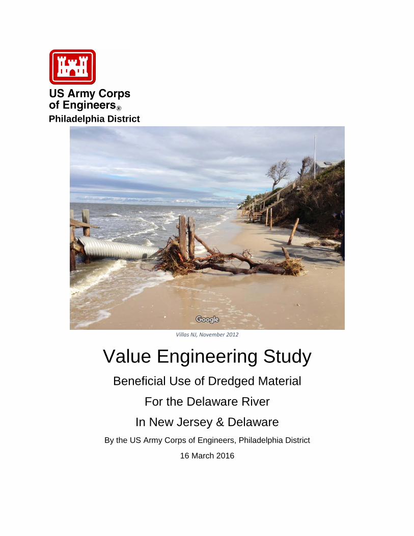
Villas NJ, November 2012
Value Engineering Study
Beneficial Use of Dredged Material
For the Delaware River
In New Jersey & Delaware By the US Army Corps of Engineers, Philadelphia District
16 March 2016

This page intentionally left blank

TABLE OF CONTENTS
1 Executive Summary ......................................................................................................................... 1
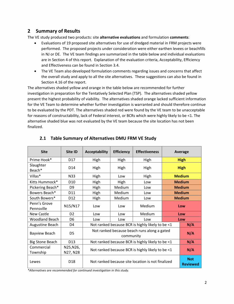
2 Summary of Results ......................................................................................................................... 2
2.1 Table Summary of Alternatives DMU FRM VE Study ................................................................. 2
3 DMU Planning Studies Background .................................................................................................. 3
3.1 Delaware River Dredged Management Utilization (DRDMU) Site Map ...................................... 4
3.2 Value Engineering in SMART Planning ...................................................................................... 5
3.3 Value Engineering Job Plan ....................................................................................................... 6
3.4 Costs and Benefits .................................................................................................................... 9
4 Study Results ................................................................................................................................. 11
4.1 N15/17 Penn’s Grove/Carneys Point & Pennsville, NJ (Proposed Levees)................................ 11
4.2 N25-28 Bivalve/Shellpile/Port Norris/Maurice River, NJ (Proposed Levees) ............................ 12
4.3 N33 Villas Beach, NJ (Proposed Beachfill) ............................................................................... 13
4.4 D2 New Castle, DE (Proposed Levee Improvements) .............................................................. 14
4.5 D4 Augustine Beach, DE (Proposed Beachfill) ......................................................................... 15
4.6 D5 Bayview Beach, DE (Proposed Beachfill) ............................................................................ 16
4.7 D6 Woodland Beach, DE (Proposed Beachfill) ......................................................................... 17
4.8 D9 Pickering Beach, DE (Proposed Beachfill) ........................................................................... 18
4.9 D10 Kitts Hummock, DE (Proposed Beachfill) ......................................................................... 19
4.10 D11 Bowers Beach, DE (Proposed Beachfill) ........................................................................... 20
4.11 D12 South Bowers Beach, DE (Proposed Beachfill) ................................................................. 21
4.12 D13 Big Stone Beach, DE (Proposed Beachfill) ........................................................................ 22
4.13 D14 Slaughter Beach, DE (Proposed Beachfill) ........................................................................ 23
4.14 D17 Prime Hook Beach, DE (Proposed Beachfill) ..................................................................... 24
4.15 Evaluation of need of Groins/ Terminal Jetties in proposed alternatives ................................. 25
4.16 Comments ............................................................................................................................. 26
4.17 Rejected Ideas ........................................................................................................................ 31
4.18 Conclusion ............................................................................................................................. 33
5 Appendix A VE Meeting Agenda ..................................................................................................... 34
6 Appendix B VE Team Roster ........................................................................................................... 36
7 Appendix C Function Analysis System Technique (FAST) Diagrams ................................................. 37
8 Appendix D VE Speculation List ...................................................................................................... 39

9 Appendix E Customer Response Worksheets ................................................................................. 41
10 Appendix F Certification ................................................................................................................. 45

1
1 Executive Summary
A Value Engineering (VE) Study was conducted at the Philadelphia District Office of the US Army Corps of Engineers on 29 February – 8 March 2016 to examine flood risk management (FRM) in 19 communities in New Jersey and Delaware being considered to receive dredged material from the Delaware River Navigation Channel and designated unconfined and confined disposal facilities to address flood risk management (FRM) opportunities. The VE team was comprised of Philadelphia District (NAP) employees and William Easley, USACE-RAO. The VE team employed the VE study methodology outlined in sections 3.3 and 3.4 of this report. This involved the integration of planning criteria along with the 6 step VE job plan to evaluate site alternatives prior to the selection of the Tentatively Selected Plan (TSP).
The VE team has produced evaluations of 19 site alternatives and formulation comments and concerns regarding the overall planning studies. The 19 sites were evaluated based on Acceptability, Efficiency, and Effectiveness in accordance with USACE planning guidance expressed in the Planning Guidance Notebook and Corps Planning Manual, as well as SMART planning guidance. The projects were not rated numerically, but ranked according to whether their ability to meet the specific criteria was High, Medium or Low (Section 3.3).
Section 2.1 outlines the recommendations of the VE team regarding the 19 site alternatives presented by the PDT. Three site alternatives appear to have potentially acceptable Benefit Cost Ratios (BCRs) of ≥1.0 and are recommended for further consideration by the Project Development Team (PDT). Four site alternatives potentially have BCRs ≈ 1.0, but lacked sufficient information for the VE team to determine whether further investigation is warranted. Eleven site alternatives potentially have BCRs ≤ 1.0, as well as constructability issues, lack of Federal interest, or anticipated lack of public acceptance, and therefore are not recommended for further consideration by the PDT. The one remaining site alternative of Lewes Beach, DE was not examined due to lack of information.
The VE team also developed 24 comments and an examination of the economic viability of groins in concert with proposed beach fills in the Delaware Bay.
In conclusion, the VE team was able to evaluate 18 of the 19 site alternatives and recommends 7 of the 19 alternative sites continue to be evaluated, and 11 alternatives be removed from further consideration for the study. After consideration of the economic viability of groins and terminal jetties in concert with beach fills, the VE Team determined that groins and/or terminal jetties should be removed from consideration for all beachfill alternatives in the Delaware Bay. The VE Team also determined that restriction of use of dredged material for FRM projects limited the number of viable projects and missed opportunities for successful use of dredged materials. There is need for a systemic approach to regional sediment management that is not currently available within the combination of existing authorizations. The VE Team recommends the removal of the study from the PL 113-2 (Hurricane Sandy) authorization, which requires a focus on FRM, in order to address regional sediment management goals and capitalize on other opportunities, such as ecosystem restoration. See Comment 7 in Section 4.16 for further information.
2
2 Summary of Results The VE study produced two products: site alternative evaluations and formulation comments:
• Evaluations of 19 proposed site alternatives for use of dredged material in FRM projects were performed. The proposed projects under consideration were either earthen levees or beachfills in NJ or DE. The VE team findings are summarized in the table below and individual evaluations are in Section 4 of this report. Explanation of the evaluation criteria, Acceptability, Efficiency and Effectiveness can be found in Section 3.4.
• The VE Team also developed formulation comments regarding issues and concerns that affect the overall study and apply to all the site alternatives. These suggestions can also be found in Section 4.16 of the report.
The alternatives shaded yellow and orange in the table below are recommended for further investigation in preparation for the Tentatively Selected Plan (TSP). The alternatives shaded yellow present the highest probability of viability. The alternatives shaded orange lacked sufficient information for the VE Team to determine whether further investigation is warranted and should therefore continue to be evaluated by the PDT. The alternatives shaded red were found by the VE team to be unacceptable for reasons of constructability, lack of Federal interest, or BCRs which were highly likely to be <1. The alternative shaded blue was not evaluated by the VE team because the site location has not been finalized.
2.1 Table Summary of Alternatives DMU FRM VE Study
Site Site ID Acceptability Efficiency Effectiveness Average
Prime Hook* D17 High High High High Slaughter Beach* D14 High High High High
Villas* N33 High Low High Medium Kitts Hummock* D10 High High Low Medium Pickering Beach* D9 High Medium Low Medium Bowers Beach* D11 High Medium Low Medium South Bowers* D12 High Medium Low Medium Penn’s Grove Pennsville N15/N17 Low Low Medium Low
New Castle D2 Low Low Medium Low Woodland Beach D6 Low Low Low Low Augustine Beach D4 Not ranked because BCR is highly likely to be <1 N/A
Bayview Beach D5 Not ranked because beach runs along a gated community N/A
Big Stone Beach D13 Not ranked because BCR is highly likely to be <1 N/A Commercial Township
N25,N26, N27, N28 Not ranked because BCR is highly likely to be <1 N/A
Lewes D18 Not ranked because site location is not finalized Not Reviewed
*Alternatives are recommended for continued investigation in this study.

3
3 DMU Planning Studies Background
The VE study examined the Beneficial Use of Dredged Material for the Delaware River in New Jersey & Delaware (DMU) feasibility studies which were originally authorized for reconnaissance phase and any ensuing feasibility phase investigations by a resolution of the Committee on Environment and Public Works of the United States Senate on October 26, 2005. The resolution directed USACE to conduct an investigation of beneficial uses of dredged material within the Delaware River and Estuary area.
In the aftermath of Hurricane Sandy (October 2012) and the subsequent passage of the Disaster Relief Appropriations Act, 2013 (PL 113-2), Congress authorized supplemental appropriations to Federal agencies for expenses related to the consequences of Hurricane Sandy. Chapter 4 of PL 113-2 identifies those actions directed by Congress specific to the U.S. Army Corps of Engineers (USACE), including preparation of two interim reports to Congress, a project performance evaluation report, and a comprehensive study to address the flood risks of vulnerable coastal populations in areas affected by Hurricane Sandy within the boundaries of the North Atlantic Division of USACE. Specifically, the Second Interim Report to Congress (dated 30 May 2013) identified existing USACE projects and studies for reducing flooding and storm damage risks in the area affected by Hurricane Sandy. The New Jersey DMU study was identified in the Second Interim Report, thereby placing additional emphasis on flood risk management (FRM).
The VE team relied on problems, goals, and objectives from the draft feasibility reports to guide discussion, comments, and recommendations. These draft feasibility reports identify “storm surge and elevated water levels from coastal storm events, combined with tidal fluctuation, surface runoff, shoreline erosion, and sea-level change causing flood-related damages to the bay shore and flood-prone urban areas along the Delaware River/Bay shoreline of New Jersey and Delaware” as a problem. The draft feasibility reports outline the following objectives to meet the goal of “improving Flood Risk Management for the bayshore and flood prone communities along and adjacent to the Delaware River/Bay portion of” both the New Jersey and Delaware shorelines:
1. Reduce flood-related impacts to people, property and infrastructure along and adjacent to the Delaware River/Bay shoreline of New Jersey and Delaware from 2020 to 2070, via the beneficial use of dredged material.
2. Increase the resiliency of coastal New Jersey and Delaware, specifically along the Delaware River/Bay shoreline, via the beneficial use of dredged material.
The feasibility studies are currently considering 19 site alternatives in both New Jersey and Delaware, listed in (Section 2.1) and shown in the Site Map (Section 3.2).

4
3.1 Delaware River Dredged Management Utilization (DRDMU) Site Map
Alternatives under Consideration during DMU VE Study 29 Feb 16

5
3.2 Value Engineering in SMART Planning
The VE job plan has similarities and overlapping processes with planning activities. As such, the opportunity exists to combine VE and planning functions into integrated activities.
In this case, the VE job plan was modified to address these planning needs. This was accomplished by evaluating the preselected 19 alternatives. This ‘blended’ approach enhanced both VE and the planning process. It is hoped that this VE effort expedited the planning process itself. The PM and VEO opted to perform the VE study to Assist in Evaluating Alternatives and Selecting TSP (see figure below). VE application at this stage assured inclusion of possible new alternatives and enhancements to those already identified; and the VE job plan was tailored to the plan formulation/selection needs.
VALUE BASEDPLANNING CHARRETTE
VE STUDY TOASSIST IN IDENTIYING ALTERNATIVES
(INTEGRATE WITH SCOPING MEETING)
VE STUDY TOASSIST IN EVALUATING
FINAL ALTERNATIVESAND SELECTING TSP
(INTEGRATED WITH PLAN FORMULATION/ SELECTION PROCESS MEETING)
OR ORAND
(OPTIONAL)
VE STUDY TOIMPROVE TSP
(INTEGRATED WITH QC, OR IPR, RA, etc.)
APPLICATION OF VALUE ENGINEERING (VE)IN SMART FEASIBILITY STUDY PROCESS
This VE Study performed between Nodes 1 & 2
6
3.3 Value Engineering Job Plan
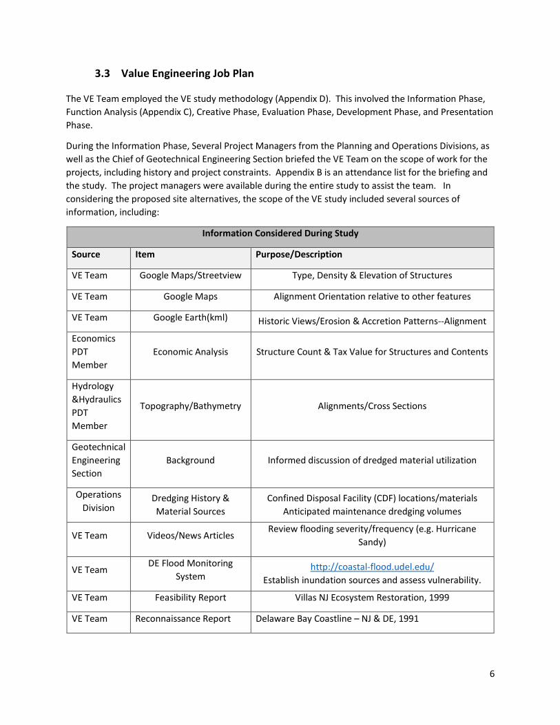
The VE Team employed the VE study methodology (Appendix D). This involved the Information Phase, Function Analysis (Appendix C), Creative Phase, Evaluation Phase, Development Phase, and Presentation Phase.
During the Information Phase, Several Project Managers from the Planning and Operations Divisions, as well as the Chief of Geotechnical Engineering Section briefed the VE Team on the scope of work for the projects, including history and project constraints. Appendix B is an attendance list for the briefing and the study. The project managers were available during the entire study to assist the team. In considering the proposed site alternatives, the scope of the VE study included several sources of information, including:
Information Considered During Study
Source Item Purpose/Description
VE Team Google Maps/Streetview Type, Density & Elevation of Structures
VE Team Google Maps Alignment Orientation relative to other features
VE Team Google Earth(kml) Historic Views/Erosion & Accretion Patterns--Alignment
Economics PDT Member
Economic Analysis Structure Count & Tax Value for Structures and Contents
Hydrology &Hydraulics PDT Member
Topography/Bathymetry Alignments/Cross Sections
Geotechnical Engineering Section
Background Informed discussion of dredged material utilization
Operations Division
Dredging History & Material Sources
Confined Disposal Facility (CDF) locations/materials Anticipated maintenance dredging volumes
VE Team Videos/News Articles Review flooding severity/frequency (e.g. Hurricane
Sandy)
VE Team DE Flood Monitoring
System http://coastal-flood.udel.edu/
Establish inundation sources and assess vulnerability.
VE Team Feasibility Report Villas NJ Ecosystem Restoration, 1999
VE Team Reconnaissance Report Delaware Bay Coastline – NJ & DE, 1991

7
VE Team NJ & DE DMUs Draft Feasibility Report
Authorization text; Opportunity & Problem statements
VE Team Delaware River Comprehensive Draft Feasibility Report
Informed VE Team on planning & evaluation criteria
Project Manager
50 Year Beach Maintenance, DE
Past beachfill maintenance history 1958-present
VE Team EBS Archives Past projects awarded by NAP
Civil Engineering PDT
Beachfill Quantities
Cost Engineering PDT
Beachfill Estimates
VE focuses on project functions rather than features. During the Function Analysis Phase, the VE Team developed a list of random functions, which were organized into a Function Analysis System Technique (FAST) showing the relationship between critical project functions and a FAST diagram was developed (see Appendix C).
Function Analysis flowed into the Creativity Phase, during which the team engaged in free-form brainstorming, resulting in the Speculation List in Appendix D. The VE study produced 2 results:
• Site Alternatives presented by the Planning PDT: The PDT is in the process of considering 19 alternative locations in NJ & DE that may benefit from the beneficial use of dredged material. During the Development Phase, the VE Team examined each of these sites currently under consideration to become part of the Tentatively Selected Plan (TSP), and presented recommendations below.
• Formulation Comments that address various formulation and design concerns related to
operations, future maintenance, ways to reduce project costs or improve the dredging, levee or beach fill projects, etc. During the Evaluation Phase, the VE Team screened the Speculation List to decide which ideas were pertinent to future design. The viable comments, marked C in Appendix D, and the rejected ideas marked X in the same Appendix, are explained in this report.
Understanding the need to combine the VE and planning processes, the VE Team developed a screening process to evaluate each of the 19 site alternatives proposed by the Philadelphia District based on Acceptability, Efficiency, and Effectiveness in accordance with USACE planning guidance expressed in the Planning Guidance Notebook and Corps Planning Manual, as well as SMART planning guidance. Planning guidance also requires consideration of Completeness of each alternative. The VE Team had insufficient information to assess Completeness and deferred determination of Completeness to the PDT.
8
• Acceptability is defined as “the workability and viability of the alternative plan with respect to acceptance by State and local entities, and the public, and compatibility with existing laws, regulations, and public policies.”
• Efficiency is defined as “the extent to which an alternative plan is the most cost effective means of alleviating the specified problems and realizing the specified opportunities, consistent with protecting the Nation’s environment.” The VE process is too accelerated to do a comprehensive analysis such as that normally performed by the Economics Branch. Efficiency was loosely judged on what the project would be protecting versus the relative expense of what would be required to adequately provide some risk reduction against flooding. Several projects were rated lower than others because raising dunes with beach fill was not enough when the communities were also at risk from the inland side due to riverine or marsh side flooding. Section 3.5 contains cost and benefit information that was available to the VE Team.
• Effectiveness is defined as “the extent to which an alternative plan alleviates the specified problems and achieves the specified opportunities.”
• Completeness (Deferred to PDT) is defined as “the extent to which a given alternative plan provides and accounts for all necessary investments of other actions to ensure the realization of the planned effects. This may require relating the plan to other types of public or private plans if the other plans are crucial to realization of the contributions of the objective.”
The projects were not rated numerically, but ranked according to whether their ability to meet the specific criteria was High, Medium or Low.

9
3.4 Costs and Benefits
3.4.1 Costs Costs for three beachfill alternative sites for the Reach E and Buoy 10 sources were provided to the VE Team: These costs are parametric and do not include periodic nourishment.
Initial Construction Cost Estimates March 2016 Reach E Source
Location Mobilization* (1)
Quantity (CY) $/CY Dredging &
Beachfill (2) Design/CM
(3) Total (1+2+3)
Prime Hook Beach $5,207,152 114,341 34 $5,119,275 $1,087,349 $11,413,777 Bowers 1 Beach $5,455,823 53,797 36 $2,544,975 $795,657 $8,796,455 Bowers 2 Beach** $5,581,013 63,352 38 $3,169,944 $813,233 $9,564,190 Slaughter Beach $5,474,755 172,206 38 $8,428,623 $1,125,717 $15,029,094 Slaughter 2 Beach** $5,474,755 74,358 39 $3,797,984 $838,622 $10,111,361 Villas $5,515,034 265,000 38 $13,087,555 $1,485,558 $20,088,147
Initial Construction Cost Estimates March 2016 Buoy 10 Source
Location Mobilization* (1)
Quantity (CY) $/CY Dredging &
Beachfill (2) Design/CM
(3) Total (1+2+3)
Prime Hook Beach $5,207,153 114,341 24 $3,539,197 $842,535 $9,588,885 Bowers 1 Beach $5,455,823 53,797 44 $3,064,600 $809,333 $9,402,285
Bowers 2 Beach** $5,581,013 63,352 44 $3,592,439 $829,301 $9,948,016 Slaughter Beach $5,474,755 172,206 26 $5,793,699 $920,715 $12,189,168
Slaughter 2 Beach** $5,474,755 74,358 28 $2,660,232 $795,657 $8,930,644 Villas $5,515,034 265,000 22 $7,734,025 $1,070,242 $14,319,301
*Mobilization costs are all similar, $/cy ranges from $22/yd in Villas NJ to $44/yd in Bowers Beach DE. **Multiple beach estimates reflect uncertainty of existing conditions and optimal beachfill design template.
10
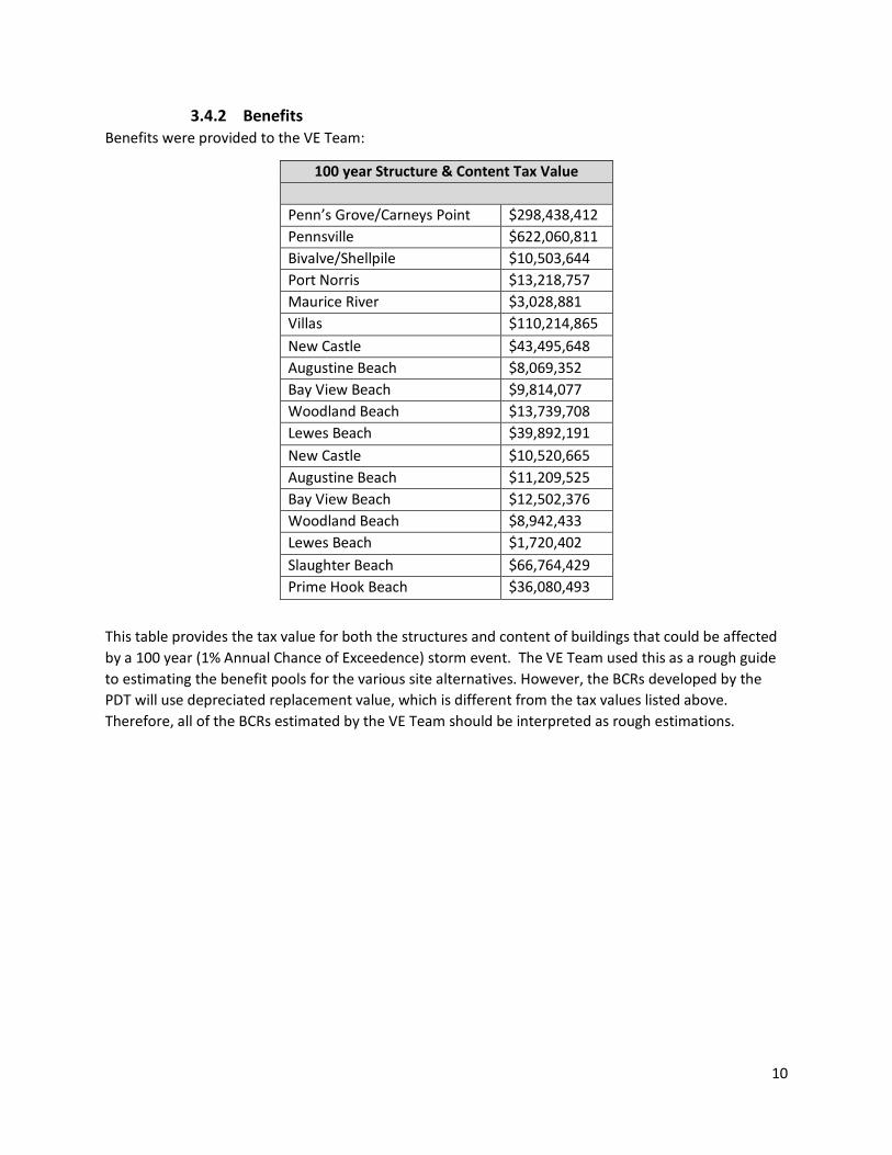
3.4.2 Benefits Benefits were provided to the VE Team:
100 year Structure & Content Tax Value
Penn’s Grove/Carneys Point $298,438,412 Pennsville $622,060,811 Bivalve/Shellpile $10,503,644 Port Norris $13,218,757 Maurice River $3,028,881 Villas $110,214,865 New Castle $43,495,648 Augustine Beach $8,069,352 Bay View Beach $9,814,077 Woodland Beach $13,739,708 Lewes Beach $39,892,191 New Castle $10,520,665 Augustine Beach $11,209,525 Bay View Beach $12,502,376 Woodland Beach $8,942,433 Lewes Beach $1,720,402 Slaughter Beach $66,764,429 Prime Hook Beach $36,080,493
This table provides the tax value for both the structures and content of buildings that could be affected by a 100 year (1% Annual Chance of Exceedence) storm event. The VE Team used this as a rough guide to estimating the benefit pools for the various site alternatives. However, the BCRs developed by the PDT will use depreciated replacement value, which is different from the tax values listed above. Therefore, all of the BCRs estimated by the VE Team should be interpreted as rough estimations.

11
4 Study Results
4.1 N15/17 Penn’s Grove/Carneys Point & Pennsville, NJ (Proposed Levees)
Planning Criteria Score: Low Acceptability: Low
• During the information phase, it was determined that USACE does not commonly support the use of dredged material for levee construction.
• The VE team was uncertain about how much dredged material is needed to qualify as dredged material utilization. If too little is used would the project be acceptable to the cost sharing partners?
• Material would either have to be placed in the Delaware River or on occupied real-estate, which would involve buyout and demolition, thereby lowering benefits and increasing costs.
• Placing levee on occupied real-estate would involve temporarily removing existing armoring and replacing it after levee construction.
Efficiency: Low
• Anticipation of high cost of levee construction offsets large benefit pool, potentially realizing low efficiency.
• Rough estimates of BCR indicates potential to be ≥ 1.0, and could be further assessed to clarify BCR using a different source material.
• Silt, sand and organic soil comprise the bulk of dredged material available for use. This material is unsuitable for levee construction without improvement of material and additional imported impervious fill for core.
Effectiveness: Medium
• The specified FRM problem would be better addressed by building a levee to Corps standards. • Given pervious nature of available dredged material, fill required by levee construction can only
be partially supplied by dredged material. Levee core and possibly other sections would need to come from elsewhere, or be improved dredged material (e.g. soil mixing). The specified opportunity of DMU would not be well addressed, due to limited/no use of dredged material.
Other:
• Killcohook Combined Disposal Facility (CDF) is a convenient source of dredged materials. • Pennsville and Penn’s Grove are geographically close and have similar existing conditions, and it
is recommended that they be combined in any future investigation.
Conclusion: The VE team does not recommend Penn’s Grove and Pennsville sites be further considered in this study, because, in general, the Corps does not accept levee construction as a viable use of dredged materials

12
4.2 N25-28 Bivalve/Shellpile/Port Norris/Maurice River, NJ (Proposed Levees)
Planning Criteria Score: N/A – not ranked b/c of low BCR
Acceptability: N/A
• During the information phase, it was determined that USACE does not commonly support the use of dredged material for levee construction.
• The VE team was uncertain about how much dredged material is needed to qualify as dredged material utilization. If too little is used would the project be acceptable to the cost sharing partners?
• In Bivalve and Shellpile, material would either have to be placed in river or occupied real-estate, which would involve buyout and demolition, lowering benefits and increasing costs.
• The community in Commercial Township might not have the resources necessary to maintain the closures that would be necessary due to road crossings.
Efficiency: N/A
• Closest source of dredged material is Artificial Island, which would involve significant hauling costs.
• Rough estimate of BCR indicates potential to be < 1.0, but could be further assessed to address retreat of marsh under ecosystem restoration.
• Silt, sand and organic soil comprise the bulk of dredged material available for use. This material is unsuitable for levee construction without improvement of material and additional imported impervious fill for core. However, this material has been found to be acceptable for marsh enhancement (thin layer placement).
Effectiveness: N/A
• Many structures abut the Maurice River, which would preclude protection from levees. • The specified FRM problem would not be better addressed by building a levee to Corps
standards. • The specified opportunity of DMU would not be well addressed, due to limited/no use of
dredged material in a potential levee. However this opportunity could be better addressed using dredged material for marsh enhancement.
Conclusion: The team does not recommend the Commercial Township sites be further considered in this study. A levee project would not offer the most effective form of flood risk management in Commercial Township because many structures abut the Maurice River and would not be protected by a levee. If a levee were constructed, it would require multiple road crossings, which would most likely be difficult for the municipality to oversee given the small size of the community. Future flood risk management consideration in Commercial Township could focus on the potential for bulkheads, elevating structures, or non-structural measures under the Delaware Comprehensive or Section 205 CAP authorities. Ecosystem restoration projects could be considered under Section 206 CAP authority.

13
4.3 N33 Villas Beach, NJ (Proposed Beachfill)
Planning Criteria Score: Medium
Acceptability: High
• High likelihood of acceptance by the State of New Jersey, local entities, and general public. • Proposed Beachfill project, as best as can be determined with information at-hand, appears to
be compatible with existing laws, regulations, and public policies. • Currently, there is an authorized, but not constructed, Ecosystem Restoration project for Villas.
Efficiency: Low
• Proposed dune and berm template has not been optimized to date, and therefore it may not be the most cost-effective beachfill geometry.
• Alternative borrow sources other than Navigation Channel E or Buoy 10 may be more cost-effective. This is based upon review of costs from 1999 Feasibility Report and 2008 LRR.
• High EAD compared to other DMU communities being investigated for potential flood-risk management benefits. BCR appears to be ≥ 1.0.
Effectiveness: High
• No apparent secondary flood inundation sources; therefore a beachfill along the coastline could be highly effective in reducing flood risk at the community.
Other:
• Applicability of using dredge material from Navigation Channel Reach E or Buoy 10 for beachfill is high.
• Unit cost to transport material to Villas from Navigation Channel Reach E or Buoy 10 compares favorably when compared to other communities being evaluated in this study. However, when compared to other potential sources such as the previously authorized Feasibility Borrow Areas, the unit cost to place sand is very high.
• Use of previously authorized sources would require switching construction authority.
Conclusion: The VE team does recommend Villas Beach, NJ site be further considered in this study, because, in general, the Corps does accept beachfill construction as a viable use of dredged materials to implement FRM.

14
4.4 D2 New Castle, DE (Proposed Levee Improvements)
Planning Criteria Score: Low
Acceptability: Low
• During the information phase, it was determined that USACE does not commonly support the use of dredged material for levee construction.
• The VE team was uncertain about how much dredged material is needed to qualify as dredged material utilization. If too little is used would the project be acceptable to the cost sharing partners?
• New Castle has historic buildings, so there would likely be a cultural impact. • Community members might also have concern about a levee blocking residents’ view of the
river. • The existing levee was repaired in 2014 at a cost of $8m; replacement of it could seem wasteful.
Efficiency: Low
• Anticipation of high cost of levee construction coupled with minimal increase in benefit pool by raising existing levee from 8’ to 12’.
• Silt, sand and organic soil comprise the bulk of dredged material available for use. This material is unsuitable for levee construction without improvement of material and additional imported impervious fill for core.
• An existing levee would need to be removed, which could be costly, especially if the material needs to be disposed of elsewhere. Planning to reuse the material carries to the high risk of the material being found unacceptable for Corps use.
• It is unclear whether utilities would need to be relocated. Depending on the utility, relocation can be expensive to very expensive.
Effectiveness: Medium
• The specified FRM problem would be better addressed by building a levee to Corps standards.
• Given pervious nature of available dredged material, fill required by levee construction can only be partially supplied by dredged material. Levee core and possibly other sections would need to come from elsewhere, or be improved dredged material (e.g. soil mixing). The specified opportunity of DMU would not be well addressed, due to limited/no use of dredged material.
Conclusion: The VE team does not recommend New Castle be further considered in this study, because, in general, the Corps does not accept levee construction as a viable use of dredged materials. FEMA grant programs can be considered as an alternate means of implementing FRM.

15
4.5 D4 Augustine Beach, DE (Proposed Beachfill)
Planning Criteria Score: N/A
Acceptability:
• Placing beachfill would involve burying existing armoring.
Efficiency:
• Augustine Beach is furthest of all sites from potential borrow sources at Navigation Channel E or Buoy 10.
Effectiveness:
• Existing armoring, groin, and boat ramp contribute to shore stabilization.
Other:
• Beachfill may hamper access to a boat ramp. • There has been no record of previous beachfill dating back to 1961. • Augustine Beach is closest to the Philly to Trenton navigation channel.
Conclusion:
Augustine Beach, DE is a community with only 37 structures with minimal potential FRM benefits. It was not evaluated using the Planning Criteria due to the likelihood of having a BCR less than 1.0. Mobilization/demobilization costs ($5m) alone make justifying a FRM project highly unlikely.

16
4.6 D5 Bayview Beach, DE (Proposed Beachfill)
Planning Criteria Score: N/A
Acceptability: N/A
This is a private beach (http://www.bayviewbeachonline.com/). It was assumed by the VE team that a Federal project would be unacceptable to the residents.
Efficiency: N/A
Effectiveness: N/A
Conclusion: No Federal interest.
Lone Access to Bayview Beach, DE (private Beach)

17
4.7 D6 Woodland Beach, DE (Proposed Beachfill)
Planning Criteria Score: Low
Acceptability: Low
• Placing beachfill would involve burying existing armoring.
Efficiency: Low
• The developed area includes 63 structures. Best professional judgment based on other recent FRM projects in Philadelphia District indicates that the BCR will be <1.0.
• Existing armoring provides some level of protection against erosion.
Effectiveness: Low
• The developed area has the Delaware River on one side and wetlands (Duck Creek) on three sides. Inundation is projected to occur from the wetlands as well as the river. Any proposed beachfill along Woodland Beach would not address this secondary inundation source.
• Complete FRM would necessarily include a ring structure around the developed areas, which would result in other issues, including lack of economic efficiency.
Other:
• There has been no record of previous beachfill dating back to 1961.
Conclusion:
Woodland Beach, DE is a community with only 63 structures with minimal potential FRM benefits. It was not evaluated using the Planning Criteria due to the likelihood of having a BCR less than 1.0. Mobilization/demobilization costs ($5m) alone make justifying a FRM project highly unlikely.
18
4.8 D9 Pickering Beach, DE (Proposed Beachfill)
Planning Criteria Score: Medium
Acceptability: High
• Given past beachfills at Pickering in 1962, 1978, 1990, and 2001 it is anticipated that acceptability would be high.
• PDT should determine whether there is a Federal interest in continuing activities accomplished by the state of DE.
Efficiency: Medium
• This project is similarly efficient to other proposed beachfills in lower Delaware Bay, but trends lower than the other beachfills as it is furthest from Lower Reach E and has one of the lowest structure and content values in the lower Delaware Bay portion of the study.
• Proposed dune and berm template has not been optimized to date, and therefore it may not be the most cost-effective beachfill geometry.
• Alternative borrow sources other than Navigation Channel E or Buoy 10 may be more cost-effective.
Effectiveness: Low
• Inundation is projected to occur from the wetlands as well as the river. Any proposed beachfill along Pickering Beach would not address this secondary inundation source. The proposed beachfill would do little to prevent flooding associated with heavy rains as the back side of the community faces the Little Creek Wildlife Area and Cattail Gut.
Other:
• The cost/benefit ratio comparing potential initial construction cost of a beachfill of 64,000cy (appx. $9-10m, 12’ high Dune, 50’ wide Berm) against Tax Value of structures and content of $10.5m is roughly 1.
• Since further economic analysis will consider only depreciated replacement value and not tax value, the initial construction estimate does not include crossovers or dune grass, and maintenance/renourishment is not factored into this consideration, it is unknown whether this project can sustain a positive benefit to cost ratio.
• Since 1990 two beachfills via hydraulic dredge have taken place. In 1990 55,400 cy was placed and in 2001 27,150 cy was placed.
Conclusion: The VE team cannot screen Pickering Beach, DE site in or out with information provided. It is recommended that it be further considered in this study, because, in general, the Corps does accept beachfill construction as a viable use of dredged materials to implement FRM.

19
4.9 D10 Kitts Hummock, DE (Proposed Beachfill)
Planning Criteria Score: Medium
Acceptability: High
• Given 12 separate beachfills at Kitts Hummock since 1961, it is anticipated that acceptability would be high.
• PDT should determine whether there is a Federal interest in continuing activities accomplished by the state of DE.
Efficiency: High
• This project is similarly efficient to other proposed beachfills in lower Delaware Bay, but trends lower than the other beachfills in efficiency as it is second furthest from Lower Reach E and has one of the lowest structure and content values in the lower Delaware Bay portion of the study.
• Proposed dune and berm template has not been optimized to date, and therefore it may not be the most cost-effective beachfill geometry.
• Alternative borrow sources other than Navigation Channel E or Buoy 10 may be more cost-effective.
Effectiveness: Low
• Inundation is projected to occur from the wetlands as well as the river. Any proposed beachfill along Kitts Hummock would not address this secondary inundation source. The proposed beachfill would do little to prevent flooding associated with heavy rains, as the back side of the community faces the Ted Harvey Conservation Area.
Other:
• The cost/benefit ratio comparing potential initial construction cost of a beachfill of 92,000cy (appx. $10m, 12’ high Dune, 50’ wide Berm) against Tax Value of structures and content of $11.2m is greater than 1.
• Since further economic analysis will consider only depreciated replacement value and not tax value, the initial construction estimate does not include crossovers or dune grass, and maintenance/renourishment is not factored into this consideration, it is unknown whether this project can sustain a positive benefit to cost ratio.
• Since 1990 six beachfills (one hydraulic dredge, 5 truckfill) have taken place. In 1996 32,850 cy was placed and in 2010 10,000 cy was placed.
Conclusion: The VE team cannot screen Kitts Hummock, DE site in or out with information provided. It is recommended that it be further considered in this study, because, in general, the Corps does accept beachfill construction as a viable use of dredged materials to implement FRM.

20
4.10 D11 Bowers Beach, DE (Proposed Beachfill)
Planning Criteria Score: Medium Acceptability: High
• Given 15 separate beachfills at Bowers Beach since 1962, it is anticipated that acceptability would be high.
• PDT should determine whether there is a Federal interest in continuing activities accomplished by the state of DE.
Efficiency: Medium
• This project is similarly efficient to other proposed beachfills in lower Delaware Bay with a distance from Reach E similar to Prime Hook Beach and Slaughter Beach.
• Proposed dune and berm template has not been optimized to date, and therefore it may not be the most cost-effective beachfill geometry.
• Alternative borrow sources other than Navigation Channel E or Buoy 10 may be more cost-effective.
Effectiveness: Low
• The proposed beachfill could provide mitigation of storm damage that would result from higher than normal wave heights and storm surge, but would do little to prevent flooding from subsidence/sea level rise or flooding associated with heavy rains on the back side of the community that faces the Murderkill and St. Jones Rivers.
Other:
• Since 1990 seven beachfills (three hydraulic dredge, 4 truckfill) have taken place. In 1998 46,240 cy was placed and in 2012 13,000 cy was placed.
• Combining this potential project with the immediately adjacent South Bowers Beach may reduce mobilization costs, potentially improving benefit/cost ratios of both beaches.
• The benefit/cost ratio comparing potential initial construction cost of a beachfill of 63,000cy (appx. $10m, 12’ high Dune, 50’ wide Berm) against Tax Value of structures and content of $12.5m is greater than 1.
• Since further economic analysis will consider only depreciated replacement value and not tax value, the initial construction estimate does not include crossovers or dune grass, and maintenance/renourishment is not factored into this consideration, it is unknown whether this project can sustain a positive benefit to cost ratio.
Conclusion: The VE team cannot screen Bowers Beach, DE site in or out with information provided. It is recommended that it be further considered in this study, because, in general, the Corps does accept beachfill construction as a viable use of dredged materials to implement FRM.

21
4.11 D12 South Bowers Beach, DE (Proposed Beachfill)
Planning Criteria Score: Medium
Acceptability: High
• Given 12 separate beachfills at Bowers Beach since 1961, it is anticipated that acceptability would be high.
Efficiency: Medium
• This project is similarly efficient to other proposed beachfills in lower Delaware Bay with a distance from Reach E similar to Bowers Beach, Prime Hook Beach and Slaughter Beach.
• The cost/benefit ratio comparing potential initial construction cost of a beachfill of 53,000cy (appx. $10m, 12’ high Dune, 50’ wide Berm) against Tax Value of structures and content of $8.9m is slightly less than 1.
• Since further economic analysis will consider only depreciated replacement value and not tax value, the initial construction estimate does not include crossovers or dune grass, and maintenance/renourishment is not factored into this consideration, it seems highly unlikely that this project can sustain a positive benefit to cost ratio.
Effectiveness: Low
• A beachfill would provide resistance to damage from bay side water level increase and storm surge, but would not wholly alleviate the problem of FRM as it does not address marsh side flooding. This is of particular concern given that the highest flood risk relates to the floodplains of the Murderkill, which flank Bowers Beach, potentially inundating the town from the marsh side.
Other:
• Since 1990 four beachfills (two hydraulic dredge, 2 truckfill) have taken place. In 1997 7500 cy was placed and in 2012 2,000 cy was placed. Combining this potential project with the immediately adjacent Bowers Beach may reduce mobilization costs, potentially improving benefit/cost ratios of both beaches. The proposed beachfill could provide mitigation of storm damage that would result from higher than normal wave heights and storm surge, but would do little to prevent flooding from subsidence/sea level rise or flooding associated with heavy rains on the back side of the community that faces the Murderkill and St. Jones Rivers. The potential for storm damage from these rivers may be greater than damage from the Delaware Bay.
Conclusion: The VE team cannot screen South Bowers Beach, DE site in or out with information provided. It is recommended that it be further considered in this study, because, in general, the Corps does accept beachfill construction as a viable use of dredged materials to implement FRM.
22
4.12 D13 Big Stone Beach, DE (Proposed Beachfill)
Planning Criteria Score: N/A
Acceptability:
• Big Stone Beach had a beachfill in 1962, delivered by truck.
Efficiency:
• Alternative borrow sources other than Navigation Channel E or Buoy 10 may be more cost-effective.
Conclusion: Big Stone Beach, DE is a community with only 14 structures with minimal potential FRM benefits. It was not evaluated using the Planning Criteria due to the likelihood of having a BCR less than 1.0. Mobilization/demobilization costs ($5m) alone make justifying a FRM project highly unlikely.
23
4.13 D14 Slaughter Beach, DE (Proposed Beachfill)
Planning Criteria Score: High
Acceptability: High
• Given 10 separate beachfills at Slaughter Beach since 1958, it is anticipated that acceptability would be high.
• PDT should determine whether there is a Federal interest in continuing activities accomplished by the state of DE.
• High likelihood of acceptance by the State of Delaware, local entities, and general public. • Proposed Beachfill project as best can be determined with information at-hand appears to be
compatible with existing laws, regulations, and public policies.
Efficiency: High
• Proposed 12 ft. dune with a 50 ft. berm template has not been optimized to date, and therefore it may not be the most cost-effective beachfill geometry.
• High EAD compared to other DMU communities being investigated for potential flood-risk management benefits. BCR appears to be ≥ 1.0.
Effectiveness: High
• Beachfill alone may not effectively address flood risk management for the community. The Mispillion River, Mispillion Inlet, Cedar Creek, and Slaughter Creek complex is immediately north of Slaughter Beach and is a potential secondary inundation source. Any proposed beachfill along Slaughter Beach coastline would not address this secondary inundation source.
Other:
• Applicability of using dredge material from Navigation Channel Reach E or Buoy 10 for beachfill is high. Unit cost to transport material to Slaughter Beach from Navigation Channel Reach E or Buoy 10 compares favorably when compared to other communities being evaluated.
• Proposed plan appears to provide and account for all necessary investments needed to address flood risk management at the community.
Conclusion: The VE team does recommend Slaughter Beach, DE site be further considered in this study, because, in general, the Corps does accept beachfill construction as a viable use of dredged materials to implement FRM.

24
4.14 D17 Prime Hook Beach, DE (Proposed Beachfill)
Planning Criteria Score: High
Acceptability: High
• Prime Hook Beach had a beachfill in 1962, delivered by truck. • PDT should determine whether there is a Federal interest in continuing activities accomplished
by the state of DE. • High likelihood of acceptance by the State of Delaware, local entities, and general public. • Proposed Beachfill project as best can be determined with information at-hand appears to be
compatible with existing laws, regulations, and public policies.
Efficiency: High
• Proposed dune and berm template has not been optimized to date, and therefore it may not be the most cost-effective beachfill geometry.
• High EAD compared to other DMU communities being investigated for potential flood-risk management benefits. BCR appears to be greater than 1.0
Effectiveness: High
• Beachfill alone may not effectively address flood risk management for the community. Large water bodies (ponds and marshes) exist “behind” community due to breach to the north at the National Wildlife Refuge. These could pose as a potential secondary inundation sources. Any proposed beachfill along Prime Hook Beach coastline would not address these secondary inundation sources.
Other:
• Applicability of using dredge material from Navigation Channel Reach E or Buoy 10 for beachfill is high. Unit cost to transport material to Prime Hook Beach from Navigation Channel Reach E or Buoy 10 compares favorably well when compared to other communities being evaluated.
Conclusion: The VE team does recommend Prime Hook Beach, DE site be further considered in this study, because, in general, the Corps does accept beachfill construction as a viable use of dredged materials to implement FRM.

25
4.15 Evaluation of need of Groins/ Terminal Jetties in proposed alternatives
Through the discussion of the various alternative sites, the VE team realized the need to evaluate groins and terminal jetties. To that end, the VE Team considered the economic viability of groins and/or terminal jetties as a possible FRM measure for the communities being investigated. Groins and/or terminal jetties should be considered in addition to beachfill for a given community and not as an alternative in lieu of a beachfill. While groins and/or jetties do not provide any protection from storm surge, they retain sand at a given community over a longer period of time, and therefore reduce future nourishment quantities needed in order to maintain a beachfill. In order to determine the economic viability of groins and terminal jetties in conjunction with a beachfill, the VE Team analyzed typical construction costs at nearby communities in New Jersey and Delaware along with typical nourishment rates that can be expected for any of the communities being investigated. One example considered was Oakwood Beach, NJ, an authorized Federal beachfill with no groins located in the Delaware River across from the C&D Canal entrance. Oakwood Beach was evaluated in a 1999 Feasibility Report, in which the 3-mile long beachfill was estimated to have an initial fill of 332,000 cy and a nourishment rate of 32,000 cy (approximately 10% of the initial fill) every 8 years. The VE Team determined that using 10% of an initial fill for a given community over an 8 year cycle would be a reasonable estimate for any of the beachfill communities being considered since Oakwood Beach is in close proximity to many of them. The VE Team was given estimates of initial fill quantities for the beachfill alternative sites being investigated. Nourishment rates have not yet been determined. The initial fill quantities needed ranged from 25,000 cy to 498,000 cy depending upon community size and geometry of the initial beachfill template. If nourishment rates are assumed to be 10% of initial fill quantities and are therefore between 2,500 cy and 49,800 cy and are reduced by 50% by the presence of groins and/or terminal jetties that would mean a potential quantity reduction between 1,250 cy and 24,900 cy. However, a 50% reduction in nourishment rates can be viewed as optimistic under most conditions. For illustrative purposes, if sand costs $35.00 per cubic yard, which is a reasonable estimate based upon rough cost numbers calculated to-date, the cost savings by reducing nourishment by 50% would be between $43,750 and $1,743,000 every 8 years or annually $5,469 to $217,875, depending upon community size. Groins require a specific alongshore spacing and length to function optimally. This spacing is typically between 500 and 1,000 linear feet and the length could be up to 300 feet. Therefore, it is very conceivable that many groins and linear feet would be needed per community. Assuming a reasonable cost of $3,000 per foot, the cost per a single groin could be as high as $900,000. It can be easily seen that the annualized amount far exceeds the annualized cost savings that could be achieved if groins and/or terminal jetties were incorporated with the initial beachfill. Considering groins and/or terminal jetties is only practical for locations that would need higher nourishment quantities. Therefore, the VE Team recommends that the PDT remove groins and or terminal jetties from further consideration.

26
4.16 Comments
C-1. Use dredged material for sacrificial berms (Speculation List # 2):
Review of beneficial uses of dredged material design guides, studies, and contacts throughout USACE indicate that it is possible to use dredged material as a sacrificial berm, though this strategy is typically employed in ecosystem restoration. (http://www.epa.gov/sites/production/files/2015-08/documents/role_of_the_federal_standard_in_the_beneficial_use_of_dredged_material.pdf)
C-2. Use sheet pile with dredged material in lieu of levees with impervious core (Consider FRP) (Speculation List # 3):
An alternate design for levee construction could use sheetpiles in lieu of impervious core to reduce footprint, and allow for higher ratio of use of dredged material. If the sheetpile is expected to be concealed, Fiber-Reinforced Pile (FRP) is suggested in lieu of steel for a longer life and reduced costs. FRP is more resistant to saline conditions and wet-dry cycling of tides. It is recommended that UV-resistance be specified in case the pile is periodically exposed due to high winds or storms.
C-3. Truck material from CDF to beaches or levee sites (Speculation List # 7)
It is possible to truck material from CDFs to alternative locations under consideration. A typical haul route is shown from Kilcohook CDF to the northernmost New Castle DE levee location to illustrate.

27
C-4 Expand authority of study to include material from additional navigation channels, i.e., C&D Canal, NJIWW, Salem (Speculation List # 8):
There are several authorized navigation channels that abut the Delaware River channel (Salem River, Mispillon, C&D Canal, NJIWW) that are semi regularly maintained and contain material appropriate for beachfill. For instance, the Salem River was considered a viable source of material for the recent initial construction of Oakwood Beach, although the Reedy Island Range of the Delaware River was ultimately used for this purpose. Dredge material from these adjacent waterways is sometimes placed in the same CDFs as Delaware River dredged material, thus potentially impacting storage capacity of the CDFs.
C-5. Consider using other authorities to best meet the goals of this project (Speculation List # 9):
Individual alternative write-ups include recommendations for other possible strategies to review proposed projects.
C-6. Pump from closest CDF to site where dredged material will be used (Speculation List # 10):
Augustine Beach, Penn’s Grove, and Pennsville are all close to CDFs and it is possible to pump directly from the CDFs to the project site without trucking, barging, or otherwise shipping the dredged material.
C-6. Use geotubes with dredged material as core for groins (Speculation List # 13):
If groins are to be used in conjunction with beachfills, use of additional dredged material in geotubes to perform this function can be considered.
C-7. Consider uses other than flood risk management (FRM) in evaluation of alternatives. (Speculation List # 16)
The Delaware River and Estuary as a system is in a sediment deficit. It is unknown whether this is due to reduced input, sediment entrapment in confined disposal areas, other causes, or a combination. A broader systematic approach that considers this and maximizes regional sediment management (RSM) practices is recommended, perhaps under a specific authorization if the approach cannot be approved under the existing Dredged Material Utilization authorization. Note that the existing DMU authorization does state “ …including transfer and transport facilities for the drying, rehandling, and transferring of dredged material, as it relates to comprehensive watershed and RSM…”. It is recommended that the approach not be exclusive to Flood Risk Management (FRM). It does not appear that use of dredged material can fully address the FRM needs of the area and limiting use of dredged material to FRM misses ecosystem restoration opportunities. This may necessitate removal from the PL 113-2 (Hurricane Sandy) authorization. A systematic approach would include consideration of ecosystem restoration and beaches within the river and estuary. Thus, the dredged material would be returned to the system, potentially offsetting the sediment deficit and facilitating a complete sediment cycle. C-8. Use FEMA claim data to prioritize sites to receive material (Speculation List # 18):
If demand for dredged material outstrips supply, alternative locations could be ranked using FEMA claim data.
C-9. Resolve potential schedule conflicts in use of MV McFarland (Speculation List # 22):
28
It was discussed during the Information Phase that the hopper dredge McFarland is limited to 70 days of operation performing maintenance dredging in the Delaware River. Currently, the arrangement is for the McFarland to spend 40 days performing maintenance dredging in the Philadelphia to Trenton project, and it is anticipated that the McFarland will be able to perform newly necessary maintenance dredging in lower Reach E of the Philadelphia to Sea project as a result of the deepening of the main channel from 40’ to 45’. It is possible the new maintenance requirements of Lower Reach E may exceed the availability of the McFarland. A possible way to mitigate this would be for the State of New Jersey to make available disposal areas for the Philadelphia to Trenton project. Current disposal site of Philadelphia to Trenton dredged material is Fort Mifflin CDF, hampering productivity.
C-10. Use dredged material as daily cover for landfill layers (Speculation List # 27):
Pennsylvania currently meets their obligation to accept dredged material for the Philadelphia to Trenton Delaware River Maintenance dredging project by having a private waste disposal company use the material for daily landfill cover.
C-11. Sell dredged material to fund Flood Risk Management (FRM) (Speculation List # 30): This study has shown that the beneficial use of dredged material and flood risk management may not be optimally compatible. It is feasible to sell dredged materials to parties who may wish to purchase it. Funds raised from this sale could be allocated specifically to FRM projects in the Delaware River basin. Though not directly used for FRM, this would satisfy the requirement of using dredged materials to provide FRM and would allow more efficient and effective FRM measures to be taken. C-12. Amend dredged material for use in levees (Speculation List # 31):
Use of dredged material in levee construction is hampered by poor structural quality and high permeability of material normally dredged from the Delaware River. It is possible that the dredged material can be amended and improved via soil mixing to increase structural quality and lower permeability.
C-13. Use floating pipe from Reedy Point to Augustine Beach (Speculation List # 32):
If Augustine Beach or Bayview Beach are to have beachfill (which the VE team does not recommend), a possible source could be Reedy Island South CDF with delivery of material via pipeline.
C-14. Identify separate templates for each beach, based on BCR and H&H analysis (Speculation List # 33) & C-23 Perform optimization by considering additional beachfill template geometries other than what has been done to-date once communities are narrowed that are being investigated for possible beachfill placement.
Typically, several berm and dune height beachfill template geometries are investigated per community during “With Project” Conditions Analysis in a Feasibility Study. This is accomplished by investigating the benefits and costs of incrementally increasing dune heights while keeping berm widths static, and incrementally increasing berm widths while keeping dune heights static. C-15. Use material from lower reach of Philadelphia-to-Trenton for fill on levees and beaches in this study (Speculation List # 17 & 23): State implications of CDF's not being identified in New Jersey.

29
Use of this source for FRM may have a high cost associated with transport given distance, but significant benefits may arise from its use due to lack of disposal areas in NJ. The VE team suggests the PDT examine this source of material further.
C-16. Require any beaches receiving fill from Federal sources to have public access, including parking (Speculation List # 15) & C-25 Public acceptance may involve significant additional cost (river walks, parking, amenities etc.) Public acceptance of beachfills and levees may involve construction of ancillary improvements to FRM measures to enhance use of the structures for recreational purposes. This is of concern for potential levee construction with respect to blocking views of the river by raising a levee. It is of concern for potential beachfill construction with respect to public access.
C-18 FRM & DMU may be served more economically by separating the two objectives.
The two objectives of beneficially using dredged material for addressing FRM are not necessarily compatible economically. For example, from the FRM perspective for many communities along the Delaware Bay where beachfill may be viable solution, obtaining sand from the navigation channel or a disposal facility could be more costly than obtaining sand from other sources such as a nearby offshore borrow area. Conversely, from the DMM/DMU perspective, transporting to and placement of suitable material at Delaware Bay communities could be more costly than disposing of material at a commonly-used facility. The FRM benefits to the communities receiving the dredged material along with any cost-saving benefits of reduced maintenance of the Delaware River Navigation Channel in O&M Costs may not offset the additional costs. The VE team could not fully evaluate all of the potential FRM benefits or the costs to the communities being investigated nor could the team determine all of the potential O&M benefits and costs from the DMM perspective to make recommendations concerning if the two objectives can be achieved. Further investigations by the PDT is needed. C-19 Combine initial construction of beachfill projects across several communities to share mobilization costs.
This concept would involve awarding initial construction projects together, for example for Slaughter Beach and Prime Hook Beach. The anticipated costs for mobilization are approximately $5m for individual beaches and while mobilization would not be cut in half if two projects were merged, some savings would result, thus improving the BCRs.
C-20 Identify what % of Dredged Material is necessary to have a project qualify as a DMU project.
One of the stated objectives of the planning study is to “Increase the resiliency of coastal New Jersey and Delaware, specifically along the Delaware River/Bay shoreline, via the beneficial use of dredged material.” It will be important to clarify the degree of utilization to qualify as acceptably meeting this objective. For instance, controlling for BCRs, does a project employing dredged material for beachfill, where no other material or structure is required, have a higher priority than a levee where dredged material is a minority component of the structure required?
C-21 Identify ramifications related to an increase in maintenance dredging of the Delaware River if dredged material is used as beachfill or levees adjacent/near to Delaware River.

30
Placement of dredged materials at the recommended sites could impact the maintenance dredging that is currently being performed to keep the Delaware River channel to mandated depths. The sites vary in distance from the main channel and will need to be assessed individually for their specific impact. It is anticipated that beachfill projects will have greater impact than levees due to shoaling/sediment transport of beach materials. This type of analysis was done during the Oakwood Beach, NJ Feasibility Study. In addition to the technical impacts that these proposed projects may have, logistical impacts also need to be considered. If increased maintenance dredging is determined to be required, will there be enough resources to perform the work (e.g. dredge, time, etc.)? Where will this additional material go? C-22 Consider alternatives to mitigate marsh side flooding as FRM risks are not entirely addressed with bayside beachfill. Many communities are surrounded by wetlands and/or other bodies of water that are secondary sources of flooding. Potential solutions (i.e. beachfill) along the Bay frontage alone would not be fully complete and address these secondary sources of flooding. The VE team acknowledges that solutions to secondary sources of flooding using dredge material for FRM only is very limited given that many of these communities are surrounded by wetlands. However, during the screening process the PDT could prioritize communities that do not have secondary sources of flooding. C-24 Improve on HAZUS data. Conduct a structure inventory.
Going forward, accuracy of benefits analysis will need to be increased. A structural inventory may be required to more accurately determine BCR ratios for remaining projects.
C-26 Determine how to tie in project limits to existing conditions while minimizing impact to wetlands.
There is a potential for dredged material from new beachfill projects to migrate into adjacent marshes/wetlands. Consideration should be given to this issue if beachfill alternatives are further developed.

31
4.17 Rejected Ideas
X-1. Use barge with booster pump between channel and beaches (Speculation List # 4)
Whether the Delaware River channel dredging is performed by USACE personnel or by contract, the contracts/delivery orders/work requests are generally written as service contracts, and the dredger has the prerogative to choose the most economical way to move material from Point A to Point B. The dredger would know the best way based on material composition (specific gravity) and pumping distance. X-2. Use sidecasting in lieu of pumping (Spec List # 5)
There are some waterways where sidecasting is the most economical way to move material, i.e., wider sections of the Ohio River, but the material being dredged from the Delaware River is not necessarily heavier sand, and it may be more inclined to promptly flow back into the navigation channel. X-3. Use dock with staging area for truck access (Spec List # 6)
This idea was based on the beachfill or levee site not being directly accessible to pumping from the river. It would not be as economical as direct pumping, and is not applicable to any of the sites under consideration. X-4. Build up levees with compacted dredged material and "armor" with impervious material (Spec List # 11)
As discussed in the above report, this is not normal Corps practice. Any penetration of the impervious shell would allow migration of the pervious material. X-5. Use geotubes with dredged material as core for levees (Spec List # 12)
This is similar to recent dune construction projects as practiced by several Districts including Galveston and Philadelphia, however it has not been accepted for levee construction because of the risk of damages if the geotextile material were punctured, even though that’s unlikely. More importantly, the material which would fill the tubes is most probably not impervious. X-6. Set up dock with pump out using booster pump in deeper water adjacent to Commercial Township (N25-28) (Spec List # 14)
Rejected for same reason as X-1. The Commercial Township levees are discussed in more depth in the above report. X-7. Construct bird island in Delaware Bay (Spec List # 19)
This stretch of the Delaware River channel is not as wide as the Chesapeake Bay where Poplar Island is a textbook case of the environmental benefits of dredged material utilization. Identifying beachfill projects is much more practical and would not take the years of public hearings and permitting a new bird island would require. X-8. Identify way for dredged material to be used as a food source (Spec List # 24)

32
X-9. Use dredged material to elevate threatened properties (Spec List # 25)
This is less economical than constructing levees or dunes, and could not be done on private properties. X-10. Use dredged material as aggregate for sea walls or other concrete products (Spec List # 26)
This is not economical. Dredged material would have to be dewatered and carefully analyzed as an alternative to borrow sand and aggregate. X-11. Identify pump-out site near rail to transport more economically than using trucks (Spec List # 28)
Rejected for same reason as X-6.

33
4.18 Conclusion
After consideration of available information, the VE Team recommends:
• Further consideration of seven of the 19 site alternatives presented • Removal of groins and/or terminal jetties from consideration. • Consideration of removal of the study from the PL 113-2 (Hurricane Sandy) authorization in
order to address regional sediment management goals and capitalize on other opportunities, such as ecosystem restoration
34
5 Appendix A VE Meeting Agenda
All meetings will be held in Philadelphia District Office, Engineering Division Conference Room, 7th floor of the Wanamaker Building, 100 E. Penn Square, Philadelphia, PA 19107. All times will be flexible, related to team processes, work schedules, breaks and lunchtimes. For instance, if the information phase takes less time than expected, the team may start other phases earlier.
MONDAY, 29 FEBRUARY 2016
8:00 AM – 12:00 AM Introductions and Agenda Brief discussion of Smart Planning process Brief introduction to Value Engineering process
INFORMATION PHASE In-briefing by Project Manager: • Overview of project history and status • Recommendations and constraints • Alternatives considered
12:00 AM – 1:00 PM Lunch 1:00 PM – 4:30 PM Continuation of INFORMATION PHASE
• Alternative dredging methods • Alternative disposal methods • Alternative disposal sites
FUNCTION ANALYSIS PHASE What are we doing? Why? How?
Create FAST diagram to show relationship of functions Homework assignment for evening: Keep a notepad and pen on your night table in case you come up with questions or ideas in the middle of the night. TUESDAY, 1 MARCH 2016 8:00 AM – 12:00 AM CREATIVITY PHASE Freeform brainstorming 1:00 PM – 4:30 PM Complete CREATIVITY PHASE EVALUATION PHASE
Screen ideas suggested during Speculation for Proposals or Comments to be developed, ideas already being done, or non-viable ideas

35
WEDNESDAY, 2 MARCH 2016 8:00 AM – 4:30 PM Complete EVALUATION PHASE
Screen ideas suggested during Speculation for Proposals or Comments to be developed, ideas already being done, or non-viable ideas Assign Proposals and Comments Go over formats and procedures for writing up ideas Begin DEVELOPMENT PHASE Write up ideas Pass write-ups on to facilitator when completed
THURSDAY, 3 MARCH 2016 8:00 AM – 4:30 PM Continue DEVELOPMENT PHASE
Write up ideas Pass write-ups on to facilitator when completed
FRIDAY, 4 MARCH 2016 8:00 AM – 4:30 PM Continue DEVELOPMENT PHASE Write up ideas Pass write-ups on to facilitator when completed MONDAY, 7 MARCH 2016 8:00 AM – 4:30 PM Continue DEVELOPMENT PHASE Write up ideas Pass write-ups on to facilitator when completed TUESDAY, 8 MARCH 2016 8:00 AM – 10:30 AM Complete DEVELOPMENT PHASE
Write up ideas Pass write-ups on to facilitator when completed
10:30 AM – 12:30 AM Team goes over each other’s write-ups, compile remaining taskers,
prepare for outbrief 1:30 PM – 4:00 PM PRESENTATION PHASE
Present findings to Project Development Team and note initial responses Discuss any remaining to-do items, i.e., uncompleted write-ups, responses from PDT during outbrief requiring follow-up revisions

36
6 Appendix B VE Team Roster
NAME / EMAIL ROLE / ORGANIZATION TELEPHONE William S. Easley, PE, CVS * [email protected]
VE Team Leader/Civil Engineer Reemployed Annuitant Office, USACE
843-813-9599
Patrick Falvey * [email protected]
Value Engineering Officer/Civil Engineer Philadelphia District, USACE
215-656-5560
Rob Lowinski * [email protected]
Hydraulic Engineer Philadelphia District, USACE
215-656-6690
Conor M. McCafferty, PE, A.M.ASCE * [email protected]
Construction & Geotech Philadelphia District, USACE
215-656-6672
Regina Kukola * [email protected]
Biologist Philadelphia District, USACE
215-656-6664
Theresa Fowler, PP, AICP * [email protected]
Project Manager Philadelphia District, USACE
215-656-6575
Scott Sanderson [email protected] Project Manager, Coastal Planning Philadelphia District, USACE
215-656-6571
Laura Bittner [email protected] Chief, Hydrology and Hydraulics Section Philadelphia District, USACE
215-656-6688
Jacob Helminiak [email protected] Hydraulic Engineer, HH&C Section Philadelphia District, USACE
215-656-6466
Preston Oakley [email protected] Economist Philadelphia District, USACE
215-656-6582
Tim Rooney [email protected]
Project Manager Philadelphia District, USACE
215-656-6592
Charlie Myers [email protected]
Operations Project Manager Philadelphia District, USACE
215-313-1115
* Value Engineering Team Member

This p
age inte
ntio
nally left b
lank

37
7 Appendix C Function Analysis System Technique (FAST) Diagrams
The key to Value Engineering is studying Functions rather than Features.
Functions are expressed as two-word phrases with an active verb and a measureable noun. In the early 1960’s, Charles W. Bytheway, a Mechanical Engineer with Sperry Rand, developed Function Analysis System Technique (FAST) Diagrams as a method to show specific relationships of important functions with respect to each other, deepen the understanding of the problem to be solved, promote discussion and flow from the Information Phase into the Creativity Phase.
FAST diagrams are Function-oriented, not time- or feature-oriented. There are several variations, but Classical and Technical are used most often in USACE studies.
Classical FAST Model:
A diagram displaying the interrelationship of functions to each other in a “how-why” logic. This was first demonstrated by Charles Bytheway and further developed by Wayne “Doc” Ruggles in 1968.
Technical FAST Model:
A variation to the Classical FAST that adds “all-the-time” functions, “one -time” functions and “same-time ” or “caused by” functions. This was developed by Richard Park and Frank Wojciechowski and is probably the most commonly used FAST type in construction-oriented projects.
Template for a Technical FAST Diagram:

38
The following FAST diagram was developed by the Value Engineering Team on 29 February 2016:
39
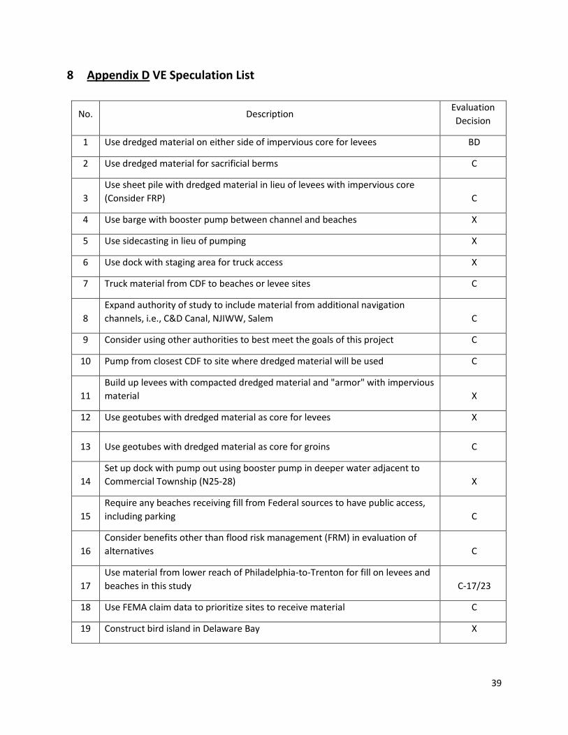
8 Appendix D VE Speculation List
No. Description Evaluation Decision
1 Use dredged material on either side of impervious core for levees BD
2 Use dredged material for sacrificial berms C
3 Use sheet pile with dredged material in lieu of levees with impervious core (Consider FRP) C
4 Use barge with booster pump between channel and beaches X
5 Use sidecasting in lieu of pumping X
6 Use dock with staging area for truck access X
7 Truck material from CDF to beaches or levee sites C
8 Expand authority of study to include material from additional navigation channels, i.e., C&D Canal, NJIWW, Salem C
9 Consider using other authorities to best meet the goals of this project C
10 Pump from closest CDF to site where dredged material will be used C
11 Build up levees with compacted dredged material and "armor" with impervious material X
12 Use geotubes with dredged material as core for levees X
13 Use geotubes with dredged material as core for groins C
14 Set up dock with pump out using booster pump in deeper water adjacent to Commercial Township (N25-28) X
15 Require any beaches receiving fill from Federal sources to have public access, including parking C
16 Consider benefits other than flood risk management (FRM) in evaluation of alternatives C
17 Use material from lower reach of Philadelphia-to-Trenton for fill on levees and beaches in this study C-17/23
18 Use FEMA claim data to prioritize sites to receive material C
19 Construct bird island in Delaware Bay X

40
No. Description Evaluation Decision
20 Expand Buoy 10 BD
21 Buy out properties in low-lying locations BD
22 Resolve potential schedule conflicts in use of MV McFarland C
23 Identify implications for CDF's not being identified in NJ C-17/23
24 Identify way for dredged material to be used as a food source X
25 Use dredged material to elevate threatened properties X
26 Use dredged material as aggregate for sea walls or other concrete products X
27 Use dredged material as daily cover for landfill layers C
28 Identify pump-out site near rail to transport more economically than using trucks X
29 Use dredged material in mines to offset acid mine drainage BD
30 Sell dredged material to fund Flood Risk Management (FRM) C
31 Amend dredged material for use in levees C
32 Use buried pipe under channel from Reedy Point to Augustine Beach C
33 Identify separate templates for each beach, based on BCR and H&H analysis C
Key:
P Proposal, develop idea in detail (Note that this may have been combined with other ideas
C Comment or design suggestion
X Rejected for technical, economic or environmental reasons
BD Being Done, or already expected to be part of design

41
9 Appendix E Customer Response Worksheets
DMU VE Study Customer Response Filled out By:
Proposed site Alternative or
formulation Comment
Customer Acceptance of VE recommendation
(Y/N)
Response/Comments
Prime Hook Beach, DE
Slaughter Beach, DE
Villas Beach, NJ
Kitts Hummock, DE
Pickering Beach, DE
Bowers Beach, DE
South Bowers Beach, DE
Penns Grove Levee, NJ
Pennsville Levee, NJ
New Castle Levee, DE
Woodland Beach, DE

42
Augustine Beach, DE
Bayview Beach, DE
Big Stone Beach, DE
Commercial Township, NJ
Comment #1 Use Dredged Material for sacrificial berms
Comment #2 Use sheet piling with levees
Comment #3 Truck material from CDF to levees or beachfill sites
Comment #4 Expand authority to include dredge material from additional navigation channels
Comment #5 Use other authorities to allow projects to proceed
Comment #6 Pump from CDF to site
Comment #7 Consider uses other than FRM in evaluation of alternatives.
Comment #8 Use FEMA claim data to prioritize sites to receive dredge material
Comment #9 Resolve potential conflicts in use of McFarland

43
Comment #10 Use dredge material as daily cover in landfills
Comment #11 Sell dredge material to fund FRM
Comment #12 Amend dredge material for use in levees.
Comment #13 Use floating pipe from CDF to nearby beachfill project.
Comments #14&23 Optimize beachfill geometry post TSP.
Comment #15 Use dredge material from Philadelphia to Trenton project
Comments #16 Amenities may be required for public acceptance
Comment #18 FRM and DMM may be better served by separating objectives
Comment #19 Combine initial construction across communities to reduce mobilization costs
Comment #20 Identify % of dredge material is necessary
Comment #21 Identify increase in maintenance dredging as a result of new projects
Comment #22 Bayfront beachfill does not mitigate marsh side flooding

44
Comment #24 Conduct structure inventory
Comment #26 Minimize impact to wetlands from beachfill projects

45
10 Appendix F Certification
This report was commissioned by the US Army Corps of Engineers, Philadelphia District
This report was compiled in accordance with SAVE International Value Methodology by:
William S. Easley, PE, CVS SAVE International No. 20040601 2200 Arch Street Unit 314 Philadelphia, PA 19103 843-813-9599 Cell