Valle Area Plan - WordPress.com
84
An Amendment to the Coconino County Comprehensive Plan Developed by the Residents of the Valle Community with assistance from the County Community Development Department Approved by the Coconino County Board of Supervisors October 18, 1999 Valle Area Plan
Transcript of Valle Area Plan - WordPress.com

An Amendment to the Coconino County Comprehensive Plan Developed by the Residents of the Valle Community with assistance from the County Community Development Department Approved by the Coconino County Board of Supervisors October 18, 1999
Valle Area Plan

VALLE AREA PLAN
Approved by Valle Area Planning Committee July 14, 1999 Planning and Zoning Commission August 31, 1999 Board of Supervisors October 18, 1999
BOARD OF SUPERVISORS
Matt Ryan, Chairman District 3 Paul J. Babbitt, Jr. District 1 Elizabeth C. Archuleta District 2 Thomas E. Chabin District 4 Louise Yellowman District 5
PLANNING AND ZONING COMMISSION
Deb Hill, Chairman Mark Sykes Janis Crosman Carl Taylor
Joshua J. Copley Nancy M. Taylor Jimmy Jensen David Watters Manny Montoya
VALLE AREA PLANNING COMMITTEE
Normand Gobeil, Chairman James Greene
Tom Jones Dave McNelly Linda Speckles
Dick Olson
COCONINO COUNTY PLANNING STAFF
William L. Towler, Community Development Director Sue E. Pratt, Principal Planner, Valle Area Plan Project Manager
David R. Mann, Transportation Planner John P. Aber, Planner II
Michelle Majeski, Planner I Francis R. Regan, Jr., Zoning Inspector

Valle Area Plan, adopted October 18, 1999 Contents
TABLE OF CONTENTS INTRODUCTION Page 1 HISTORY Page 5 VALLE VISION STATEMENT Page 9 UTILITY INFRASTRUCTURE Page 10 Water Page 10 Wastewater Page 11 Other Utilities Page 12 Solid Waste Page 13 Lighting District Page 13 Utility Infrastructure Goals Page 14 Utility Infrastructure Policies Page 14 PUBLIC SAFETY Page 16 Law Enforcement Page 16 Fire Protection Page 17 Emergency Medical Services Page 20 Public Safety Goals Page 21 Public Safety Policies Page 21 COMMUNITY Page 23 Schools Page 23 Parks and Community Center Page 25 Other Community Services Page 25 Community Goals Page 26 Community Policies Page 26 TRANSPORTATION Page 27 Existing Roadway System Page 27 Road Improvements Page 28 Pedestrian Pathways and Trails Page 30 Traffic Safety Page 31 Air, Rail and Alternative Transportation Page 32 Regional Transportation Issues Page 32 Transportation Goals Page 33 Transportation Policies Page 33
Valle Area Plan, adopted October 18, 1999 Contents
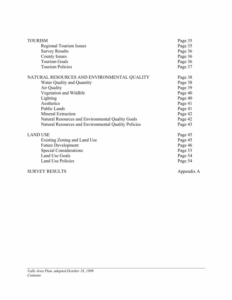
TOURISM Page 35 Regional Tourism Issues Page 35 Survey Results Page 36 County Issues Page 36 Tourism Goals Page 36 Tourism Policies Page 37 NATURAL RESOURCES AND ENVIRONMENTAL QUALITY Page 38 Water Quality and Quantity Page 38 Air Quality Page 39 Vegetation and Wildlife Page 40 Lighting Page 40 Aesthetics Page 41 Public Lands Page 41 Mineral Extraction Page 42 Natural Resources and Environmental Quality Goals Page 42 Natural Resources and Environmental Quality Policies Page 43 LAND USE Page 45 Existing Zoning and Land Use Page 45 Future Development Page 46 Special Considerations Page 53 Land Use Goals Page 54 Land Use Policies Page 54 SURVEY RESULTS Appendix A
Valle Area Plan, adopted October 18, 1999 Page 1
INTRODUCTION
On May 20, 1996 the Coconino County Board of Supervisors appointed a citizens’ committee to develop a special area plan for the Valle area. The Valle Area Planning Committee was comprised of eight members and included a mix of local residents and business operators. This committee was formed and the plan process initiated at the request of community members. The committee held their first meeting on June 26, 1996, and held 34 meetings in the following three years. A community visioning session was held on June 18, 1997 and an open house to review the final plan was held on June 16, 1999. Purpose and Scope The purpose of the Valle Area Plan is to ensure that future development in the area is in the interest of public health, safety, and welfare, that it is not detrimental to the established character of the community, and that it preserves or enhances the special characteristics that define the Valle Area. More specifically, the plan serves as an amendment to the Coconino County Comprehensive Plan, and guides the decision-making processes of the Planning and Zoning Commission and Board of Supervisors in their consideration of zone changes, subdivisions, conditional use permits, and other development-related proposals. The plan does not identify specific land uses for specific locations, but sets forth goals and policies designed to protect the special characteristics of the community, while allowing for orderly, well-planned, and appropriate development. The plan has no fixed time period, but is intended to be applicable for approximately 10 years. The plan may be amended periodically, as needed. During the life of the plan, any affected party may request amendments to the Plan, which would be considered by the Planning and Zoning Commission and Board of Supervisors through a public hearing process much like a zone change or other development proposal. Eventually, if conditions change sufficiently to warrant a major rewrite of the plan, the Board will most likely appoint another citizens’ committee to accomplish that task.
Study Area The study area was established by the Committee during the first few meetings. The plan area extends north to the Kaibab National Forest boundary, to the south it extends to the Red Lake Area Plan boundary at Howard Lake, and, it extends approximately seven (7) miles west and eight (8) miles east of Highway 64. The Plan area encompasses approximately 300 square miles (see map on previous page). At one point the Committee was petitioned by a property owner to amend the study area boundaries by removing the Blair Ranch property. Approximately 41,600 acres of the ranch are within the plan area boundaries (35,200 private land and 6,400 leased State Trust land) and

Valle Area Plan, adopted October 18, 1999 Page 2
were requested to be withdrawn. At a Planning Committee meeting held April 15, 1998 a quorum of the Committee members voted unanimously to keep the boundaries as originally drawn. The Planning Process The planning process began with the appointment of a citizens’ planning committee by the Board of Supervisors in May, 1996. The committee was originally comprised of eight (8) members. One member relocated out of the study area, and two others resigned during the third year of the process. The first to leave was replaced, the other two were not, and the committee was reduced to six members. The composition of the Committee included a local rancher, the manager of the Valle airport, a local realtor, a resident, and two Valle business owners/residents. The committee first determined the study area boundaries, and then identified the planning issues within the study area. The planning issues included public safety, water, utilities, future land use, public lands, transportation, community, and natural resources and environmental quality. The next phase of the planning process was the gathering of information to document existing conditions and trends related to each of the planning issues. Representatives from various public agencies and utilities addressed the committee during this process. A community survey was distributed during the planning process to obtain public input. After the information gathering was completed and the results of the community survey received, a draft plan was developed. An open house was held on June 16, 1999 to allow the public an opportunity to review the draft and provide comments. In addition to the committee members there were approximately 12 others in attendance at this open house. The draft Valle Area Plan was finally approved by the Committee at their last meeting held on July 14, 1999. The most discussed element of the plan related to the possible adoption of a Design Review Overlay (DRO) Zone for the study area which would apply to commercial, industrial, public utility installations, conditional uses, and multiple family residential uses. A majority of the committee did not support the creation of another level of review, but the plan does include policies that are intended to address some of the same issues that would be pertinent to a DRO. Community Participation All of the planning committee meetings were open to the public, although attendance by the public was very limited, and many meetings were held without any audience. During the course of the three years the plan process was underway, the Committee experimented with alternating the meeting times from afternoon to evening in an effort to increase attendance. A mailing list was developed from attendees at the meetings and any other interested persons who requested to be updated on the process. There were approximately 60 names which were mailed meeting agendas and minutes, and draft plan sections.
Valle Area Plan, adopted October 18, 1999 Page 3
A community visioning session was held on June 18, 1997. Approximately 20 people were in attendance at this evening session including the committee members. The work done at this session was the basis of the Valle Vision Statement included in this plan and which provides the basis for the goals and policies of the plan. During the months of July, August, and September 1997 the Committee developed, administered and tabulated a resident and owner survey. Due to the overwhelming number of absentee-property owners of undeveloped land within the study area, the Committee decided to limit distribution. The survey was hand delivered by Committee members to area residents, and were also made available at local businesses. Approximately 300 surveys were distributed, with 68 completed and returned. A special meeting was held on October 8, 1997 to go over the results of the survey. Approximately 13 residents attended this special meeting. The results of the survey are included as an appendix to this plan and are referred to throughout the text of the plan. A final open house was held on June 16, 1999. Approximately 12 people attended this meeting in addition to the committee members. A map of the plan study area, and goals and policies were on display in the Valle Airport for one week prior to the open house to encourage greater public involvement. Implementation The Coconino County Zoning Ordinance and Subdivision Ordinance are the primary tools available for implementing County plans. Both ordinances include requirements that the Planning and Zoning Commission and Board of Supervisors must make certain findings of fact in order to approve zone changes, conditional use permits, and subdivisions. One finding of fact required for approval of all such development proposals is that the proposal is consistent with the goals, objectives, and policies of the Coconino County Comprehensive Plan and any specific plan for the area. The Valle Area Plan contains specific goals and policies related to future development in the study area, and serves as the official guide for future decisions by the Planning and Zoning Commission and Board of Supervisors. Most development approvals are accompanied by conditions of approval to address certain permit requirements, site improvements, and property development standards. The conditions of approval further serve as a mechanism to ensure compliance with the policies of the Comprehensive Plan and Area Plan. In addition to development proposals, the goals and policies of the Area Plan should be considered by the Board of Supervisors as they make other administrative decisions affecting the study area, and as they direct the various County departments in their respective administrative functions. The plan also includes policies for the County to develop and work in partnership with other agencies in achieving some of the plan goals. While this plan is not binding on other agencies (i.e., U.S. Forest Service, State Land Department, Game and Fish, ADOT), it is the hope that

Valle Area Plan, adopted October 18, 1999 Page 4
agencies who are working in the study area will be made aware of the plan and work towards conformance with its goals and policies. The Valle Area Planning Committee expressed an interest in continuing reviewing and commenting on development proposals which are submitted for property within the study area. They would specifically like to be consulted for any major development proposals. Although there is no formal mechanism to create a local review board, there is precedence to informally reconvene the committee to review major proposals prior to hearing by the Planning and Zoning Commission and Board of Supervisors.

Valle Area Plan, adopted October 18, 1999 Page 5
HISTORY Although the Valle area remains sparsely populated and has only limited services, some of the long-time residents see a lot of change from the old days. There is no formal written history of Valle. The following narrative incorporates information found in a few published sources, some remembrances of long-time residents as written in the Valle Community Newsletter, general recollections of some of the members of the Valle Planning Committee, and records of the County Assessor’s and Community Development Departments. This history is provided as an outline of the progression of change in the Valle area and a general timeline of when different changes occurred. Historically, sheep and cattle ranching have dominated the use of land in the Valle area. In fact, the name Valle comes from Valle Station which is situated on what is now the Bar Heart Ranch approximately 3.5 miles due west of the junction and on the south side of Spring Valley Wash. According to the book Rails to Rim, by Al Richmond, Valle station was originally built as a spur in 1899 for the Grand Canyon Sheep Co., it was rebuilt as a siding in 1905 by Santa Fe Railroad, and extended in 1929. Original development at the site included a section house, bunkhouse, gang house, railroad telephone, and a 37 car siding for cattle and sheep loading. The loading chutes are still used, but livestock is hauled by truck now, railroad cars are no longer used. The Grand Canyon Sheep Company was consolidated with the VVV (3V) Livestock Company in 1935 and became the Arizona Livestock Company and ran what was known as the Valle Ranch. According to Helen Pearson’s recollections in the Valle Community Newsletter (Sept. 1994) the range for the ranch “stretched several miles east of the Grand Canyon Highway, and as far west as was needed for the sheep operations—Moore Place, Black Tanks, north to Willaha, and south nearly to Red Lake.” This ranch was split in September 1940 with the portion east of the railroad sold to John Osborne and the west part to E.M. Smith. Portions of the Osborne ranch remain under ownership of two Osborne daughters, Billie Osborne Wingfield (Wingfield Ranch) and Cherrie Osborne Blair (Bar Heart Ranch). Local ranchers recall good rains in the 1920’s keeping the grass high and lush for the sheep. In addition to the Bar Heart and Valle, area ranches have included Vic Watson’s Willaha Ranch, Babbitt’s CO Bar and Cataract, John O’Hare’s Espee, Manterola, Wingfield, Ramon Aso’s Howard Lake Ranch, and Howard Sheep Co. With the development of the highways the area identified as Valle moved to the east and to most people it refers to the area around the junction of State Route 64 and U.S. Highway 180. According to the Arizona State Board on Geographic and Historic Names (ASBGHN), the earliest map in their collection placing Valle at the Junction of Arizona Highway 64 and U.S. 180 is the Arizona Highway Department General Map of Arizona dated 1966. ASBGHN research revealed that road maps from the 1920's and 1930's do not show the present community of Valle or the Valle airstrip. The 1948 Coconino County General Highway Map shows the airstrip at Valle but no community, referring only to the railroad siding
Valle Area Plan, adopted October 18, 1999 Page 6
The name Valle is Spanish for Valley. According to Arizona’s Name: X Marks the Spot, by Byrd Howell Granter, in the mid 1920's the name was changed to Prado which is Spanish for “meadow”. However, because there was already another Prado on the Prescott-Phoenix (Peavine) Railroad, the name was changed back to Valle. The dedication of Grand Canyon National Park in 1919 promoted more travel to the area impacting and providing incentive for development in the Valle area. The Park dedication, along with the opening of a new highway in the late 1920’s-early 1930’s (and which was rebuilt in 1953-54) along with the end of rail service to the Canyon in 1969 provided a traveling public which required services along the way. Part of the Wingfield Ranch was purchased by developers and subdivided into the approximately 7800 lot Grand Canyon Subdivision commencing in the 1960's, thus opening up a large amount of private land for development. Early plans submitted by the subdivider to the County showed sites for parks, riding trails, low, medium and estate density residential, major and local commercial, school sites, and a “state institution” site. Due to lack of utilities and difficulty in accessing much of the property, development has been very slow, with less than 5% of the lots developed. Clear Aire Estates, part of the Wilson ranch was subdivided in 1970, due to access problems and lack of utilities, it has remained undeveloped. Woodland Ranch, formerly part of the Wingfield ranch, was split into 196 lots of 36+ acres in 1982. Grand Canyon Ranches was split into 39 40-acre lots in 1984. In the summer of 1998 Howard Mesa Ranch was sold and Arizona Land and Ranches commenced development of it for residential use. The Valle airstrip was established in 1940 as the main airport serving the Grand Canyon National Park. There is local recollection that the runways were maintained through World War II for transporting bombers across country. Some of the original buildings associated with early airport operations burned down in the 1980’s. Some of the airport history is unclear. At one point there was a facility located at Red Butte, between Valle and Tusayan. It’s not clear when that was and how that related to the Valle Airport. According to J. T. Robidoux’s daughter, Lorraine Collins, Robidoux ran the airport commencing in 1959; purchasing it from the landowner a few years later. It was after that time that TWA ceased their operations from Valle. From 1959 until approximately 1964 Bonanza Airlines ran two commercial flights a day from Valle. One was a Valle-Phoenix flight, the other Valle to Page. Fred Harvey bused passengers back and forth from the Grand Canyon National Park to the Airport. The airport was removed from the Federal Aviation Administration charts subsequent to that, but is back on the map after being re-established in 1991 by John Seibold. In addition to rebuilding the airport including a terminal building and hangars, John Seibold has created a master planned community on the section of land including a 100 lot Mobile Home Park established in 1996. The Planes of Fame Air Museum is also established on this property.
Valle Area Plan, adopted October 18, 1999 Page 7
Commercial development came to Valle first in the late 1940’s and early 1950’s. A restaurant and gas station were established by J.T. Robidoux to serve airstrip users. In the late 1950’s a motel was established in the same area with cabins relocated from Grand Canyon National Park. The hotel burned to the ground in the 1980’s. A gas station was built on the west side of Highway 64 north of the junction in 1961. Irv Pearlstein, one of the subdividers of Grand Canyon Subdivision, established a gift shop, land office, and restaurant in the early 1960’s on the east side of Highway 64 north of the junction. A gas station was built in 1970 on the site of the Rock Shop. Although there was a Rock Shop established earlier, the current Rock Shop wasn’t established until 1988. In 1970 a Conditional Use Permit was granted to Hudi and Linda Speckles to establish Flintstone’s Bedrock City, including a restaurant and amusement park. An RV Park was added in 1975. In 1973 property south of Flintstone’s and north of the Rock Shop was approved for a travel trailer park, grocery store, curio shop, and land office for sales of land in the Grand Canyon Subdivision. In 1978 a gas station was established, and in 1980 a 15 unit motel was added to the site. A conditional use permit was approved to add 11 more units in 1985. Records of the assessor’s reflect that 13 units were added to the tax roll in 1987. Sometime in the late 1980’s/ early 1990’s all of the former uses of this property were abandoned and the motel units are maintained to accommodate overflow guests of the Grand Canyon Inn. William and Lorraine Collins began development of the Grand Canyon Inn between 1982 and 1984 commencing with the restaurant, gift shop, and 34 motel units. Twenty more units were added in 1992, and 20 more in 1994. A convenience market with gasoline sales and food service was added in 1999. James and Lonny Greene established the Egyptian Teepee gift shop in 1979. Other gift shops in the area include Sinagua Trading Post built in 1976; Grand Canyon Mercantile built in 1972 by Cecil Fisher; and Double Eagle Trading Post built by Peter Klein in 1984. Lack of local utility service has long been a problem for Valle. Water was hauled until the mid-1990’s when two local wells were finally established. According to the Valle Community Newsletter, Valle residents in the 1940’s had to order water weeks in advance. According to the newsletter, water would be ordered from the City of Williams through the Santa Fe Freight Office. One car of water, with a capacity of 10,500 gallons, cost $18 in 1946. By the 1960’s the price of water was up to $54 per car. The use of railroad cars for hauling water terminated in 1965. Private water haulers were used and water was hauled from either Williams or Bellemont until the local wells were established. Phone service has also been a problem, particularly for local businesses. Dial phones weren’t available in Valle until 1979 and then only with party lines. This meant that the businesses had to share phone service. According to area residents reasonable phone service was not available
Valle Area Plan, adopted October 18, 1999 Page 8
until US West put up their first tower in 1993. Phone service is still limited to primarily the area within one mile of the junction. APS first extended power to the Bar Heart Ranch in the mid-1950’s, this was during the time that lines were being extended to the Grand Canyon. Three-phase power, necessary for more intense development, was not available until 1999. Community events have moved from barbeques with sheep shearing and shipping in the early part of the century to bingo games as fundraisers for the local volunteer fire department at the end of the century. Although Valle has not become a fast-paced metropolis as reflected by the original development plans for Grand Canyon Subdivision, it has changed in character to some degree from the remote, ranchland of its early years. However, the rural character reflected in the recollections of long-time Valle residents reflect a quality of life that many current residents still identify with and hope to preserve. “Silence broken only by the wind, miles of space to ride a horse, the full moon rising over the flats, and the howling of coyotes.”
Valle Area Plan, adopted October 18, 1999 Page 9
VALLE VISION STATEMENT Valle is a unique community emerging from a history of limited growth that was primarily due to the lack of basic services (i.e. water, phone, electrical) and no local economy. But Valle has a future of promising opportunities. Due to its location at the junction of Highways 180 and 64, the main routes to the South Rim of the Grand Canyon, Valle is uniquely situated. With increasing tourism to the region and currently limited private land base closer to the Canyon in Tusayan, there are opportunities to assist in providing visitor services in Valle. Valle would like to maintain its freedom of expression through varied architecture and business themes. However, this proximity to the Grand Canyon National Park also requires consideration and respect for the unique environmental sensitivity of the region. Although only 30 miles from the Grand Canyon National Park, the environment in Valle is very different from the environment surrounding the main South Rim portion of the Park. This contrasting environment is part of the essence of what is Valle, and preserving it is important. It is the uniqueness of the area which emphasizes the diversity important to the residents, and which is a critical element to maintain in developing a vision for the future. Valle as a Community Valle is a community, which respects diversity and provides a variety of housing and economic opportunities, while retaining its rural character. While many people have chosen Valle as their home or purchased land there for future development due to the remote location and rural lifestyle it offers, there are also people who came to the area because of affordable land costs or due to employment. This mix of people comprises the Valle community. While there are some residents who prefer to maintain a more isolated lifestyle, there are others for whom neighborly events are an important aspect of where they live. In envisioning a future for Valle, it is critical to ensure that these divergent lifestyles can be maintained and coexist. Valle envisions becoming a viable community which meets many needs of its residents. These include the availability of basic services, both rental and ownership housing options, and economic opportunities. Valle as Provider of Visitor Services In addition to addressing the needs of residents Valle provides services to visitors to the region, particularly those traveling to the Grand Canyon. Due to its location at the junction of Highways 180 and 64, Valle has an opportunity to provide visitor services to travelers who come through Flagstaff as well as Williams. With a large land base, Valle can support some tourist-oriented facilities such as lodging and restaurants. Due to regional issues related to growth, the development of visitor services is accomplished in a manner sensitive to potential impacts.

Valle Area Plan, adopted October 18, 1999 Page 10
UTILITY INFRASTRUCTURE WATER The lack of a local water source and supply has historically been a limiting factor in the growth and development of Valle. There is no local source of surface water available. The groundwater aquifer is at such a depth that drilling wells has been cost prohibitive. However, in 1994 two wells were developed in the Valle area and are producing. Prior to the development of the well at Valle Airport and the one at Grand Canyon Inn residents and business owners depended on hauling water by truck from Williams and Bellemont. There is no community water system serving the Valle area. However there are three systems which are defined as public water systems and fall under ADEQ (Arizona Department of Environmental Quality) regulations for such. These systems are the Grand Canyon Inn, Valle Airport, and Sage Valley Mobile Home Park in Woodland Ranches. A public water system is defined as serving a minimum of 15 service connections or an average of 25 persons for at least sixty days a year. The Grand Canyon Inn property has a water system which serves its hotel, restaurant, gas station/market, trailer park, and owner’s residence and has public water sales facilities. This system consists of two 36,000 gallon water storage tanks and a pumphouse. In 1995 a Conditional Use Permit (UP-95-43) was approved for the water sales. At that time the proposed use included trucking water to Moqui Lodge north of Tusayan, Sage Valley Mobile Home Park, and to Phoenix for bottling. The Grand Canyon Valle Airport has the most extensive water system. It currently provides service to the 100 space Canyon Valle Mobile Home Park, the airport terminal and associated uses. Future development on the airport property will also tie in to this water system. A conditional use permit for public water sales was approved in 1995 (Case No. UP-95-39 ). The system at this site consists of two 32,000 gallon storage tanks, a pump house, and coin operated sales facility at the well site. Sales are to local residents and commercial water haulers. There are six 32,000 gallon storage tanks which were established to serve the mobile home park. An additional six 32,000 gallon storage tanks were established with the airport to serve the terminal and related uses. Storage capacity includes that set aside for fire protection as well as domestic water use. The third existing water system in the study area serves the Sage Valley Mobile Home Park in Woodland Ranches. Unlike the Grand Canyon Inn and Valle Airport systems, this one relies on hauled water for its supply. Two 60,000 gallon water tanks store the water that serves the park. Water is hauled by a commercial hauler from either Bellemont or Valle. When this park was first being proposed the State Department of Health Services would not approve a public system which relied on hauled water. This policy was subsequently changed, allowing this development to be reconsidered and eventually approved. WASTEWATER

Valle Area Plan, adopted October 18, 1999 Page 11
Regulations pertaining to wastewater disposal and wastewater systems are developed and enforced by ADEQ. However, in Coconino County the State has delegated permitting, inspection, and enforcement authority to the County Health Department for conventional septic tank systems and most alternative systems. ADEQ still maintains regulation and control over package treatment plants and other community wastewater treatment facilities. There is no community-wide sewer system serving the study area. Most properties are served by on-site systems. The exceptions are the same three developments that provide water through community systems, each of which has a community wastewater disposal system. The Grand Canyon Inn operates a treatment plant that serves the hotel, restaurant, gas station, trailer park, and owners residence. The treated effluent is utilized for watering landscaping. When the Grand Canyon Valle Airport was re-established in the late-1980’s, the terminal was tied into a conventional septic tank and leach field system. However, with the subsequent approval of a master plan of development, and with the increasing development on the site, the development of a sewer treatment plant became more appropriate. The treatment plant was developed in conjunction with the mobile home park. It is approved for 45,000 gallons per day which should be able to accommodate much of the anticipated future development. Eventually, the part of the airport that is on individual septic systems will also be tied into the sewer system. Sage Valley Mobile Home Park has a state approved system to serve 132 spaces, which consists of 8 septic tanks with a total capacity of 42,400 gallons and accompanying leach beds. Each mobile home is connected to this system. Lot size can limit the ability to accommodate wastewater treatment on site for larger commercial and industrial projects. The ability to deal with these limitations was addressed with a proposed commercial complex at the junction of U.S. Highway 180 and State Route 64. The Grand Canyon Resort Properties (a.k.a. Thriftway) project, approved in 1994 (Case No. UP-94-38), proposed a 100 unit motel, restaurant, gift shop, convenience market and gas sales on 8 acres in the CG-10,000 (Commercial General) Zone. Water was to be provided by an on site well. However, the wastewater generated by these uses was to be disposed of on a 40 acre parcel located approximately one-half mile north of the proposed development. On the commercial property would be a pumping station, and lines in ADOT’s Highway 64 right-of-way would carry the waste to the treatment plant site. The project has not been built as of the time of the writing of this Plan. For the majority of the study area wastewater disposal is handled by individual on-site systems. Septic tanks and leach fields serve most of the developed properties in the study area. There may be some areas with unacceptable perc rates where alternatives to leach field systems would be required. There are also a number of occupied properties with outhouses or other inadequate or nonexistent waste disposal methods. Due to limited water supply composting toilets are an acceptable alternative in some cases. However, graywater from other sources must be disposed

Valle Area Plan, adopted October 18, 1999 Page 12
of in a septic/leach field system. Composting toilets only eliminate 40% of water usage. Although the Valle area is very sparsely populated now, there is a concern regarding the potential impact of individual septic systems on groundwater if there was total buildout of the area. There are over 7000 lots in the Grand Canyon Subdivision. However, it is the opinion of the County Environmental Health Department that contamination of groundwater should not be too much of a concern given the circumstances in the area such as one acre lots, generally low gallon usage, depth to aquifer, and rapid percolation. OTHER UTILITIES The limited availability of other utilities in the study area has been another factor restricting development. Due to the remote location of much of the study area electricity and phone service is not available. In these areas alternatives such as generators and solar electricity are used. In some areas propane is used instead of electricity. There are two bulk propane storage facilities in Valle. There is no natural gas available in the study area. In areas where electricity is available it is provided by Arizona Public Service (APS). These areas are primarily served by overhead lines. Some of the newer areas, such as Valle Airport including the Canyon Valle Air Park, have all of the utilities underground. Only recently has a three-phase substation been established in the study area. This has become critical due to the development that has been occurring in the community, including the well sites. APS anticipates that this substation will be able to handle anticipated growth in the Valle area through 2006. Although the entire study area is currently in the service area of APS, limitations in providing service to some of the remote areas include topographical constraints and, more importantly costs. The cost to extend lines a distance of more than 1000 ft is the burden of the property owner requesting service. Costs to run lines further than 2000 ft. are revenue based. Some of these costs can be recouped over five years if other customers come on line and utilize that extension. The more customers, the more cost-effective it is. If there are five qualifying customers to be served by the same line extension that would allow for 5000 ft. at the utility company’s expense. Although APS prefers underground lines since there is less exposure to the public and they are better protected from lightning strikes, the additional cost is at the expense of the property owner requesting the extension Until recently phone service in the Valle area has been minimal, with most residents and businesses relying on radio phones. In 1992 U.S. West obtained approval through the conditional use permit process (UP-92-34) to establish an antenna on property at the 180/64 junction. In 1993 this use permit was amended (UP-93-29) and a 60' tall tower with a microwave dish attached was established bringing phone service to at least a small portion of the community. U.S. West currently provides service only within a one mile radius from the junction where their microwave tower is located. US West has stated that they will not provide

Valle Area Plan, adopted October 18, 1999 Page 13
service beyond that boundary, but that the Telecommunications Act of 1996 allows other providers to come in and provide service in competition with U.S. West. One such provider is Midvale Telephone out of Utah that is pursuing (1997-1999) approval from the Arizona Corporation Commission to provide service outside of the U.S. West one mile radius area. However, costs for line extensions to the more remote areas will still be prohibitive in providing service to all areas. In these cases radio phones will still be relied on. Modern technology, such as cellular phones, may help fill in the gaps as well, although the towers necessary to provide service to cell phones are not in place to provide uninterrupted service areas. An issue related to the electric and phone utilities is the location of their substations on property that is so prominently located. Generally, these types of utility stations should be located in areas that are not visually dominant in a community. When APS came in to locate the three-phase substation they were successful in locating a parcel that was still centrally located, but not so much in the line of view from Highways 64 and 180. SOLID WASTE Disposal of solid waste at authorized sites is the responsibility of individual residents and businesses. Currently the only approved landfill in Coconino County is the City of Flagstaff’s Cinder Lakes Landfill located northeast of the Flagstaff City limits in the Doney Park area. The County operates transfer stations in several locations in the county. The closest transfer stations for Valle residents are in Tusayan and Williams. There is an abandoned unpermitted landfill site on the Bedrock City property. Due to the remoteness of the area and the sizable amount of public land, illegal dumping is a critical problem. There are some private haulers who operate in the area, however, they serve primarily businesses and not residential property. According to the County Department of Public Works, location of a transfer station in Valle would probably require an increased population, although an argument could be made to locate one there. Costs to the County for operating one in Valle could be less than operating one in Tusayan, particularly due to the distance waste would be hauled. However, the greater issue could be the limited capacity of Cinder Lakes Landfill. Siting new landfills is difficult due to increasingly strict federal regulations. This makes the cost of landfilling expensive. Recycling and composting become important by removing materials from the waste stream before they get to the landfill. LIGHTING DISTRICT Lack of street lighting, particularly in the area of the Highway 64/180 junction, has been a concern expressed by some local business owners and residents. Safety for pedestrians crossing the highway between businesses is the main concern. The logistics associated with the installation and maintenance of street lights is not a straightforward matter. One option is the formation of a special district, as was done in Tusayan. Over 51% of the property owners would have to agree to the formation of a district and assessments would be collected through property tax bills. APS would cover the cost of the fixtures and installation; the district is billed for the

Valle Area Plan, adopted October 18, 1999 Page 14
electric usage. The property owners pay for the electricity through special tax assessments. The assessment would be based on the amount of street frontage for each parcel. The formation of a special district for street lighting is probably the best approach if the property owners desire such lighting. If street lights are installed, there is of course the issue of respecting the desire for dark sky, which was rated as an important natural resource by survey respondents. UTILITY INFRASTRUCTURE GOALS 1. To develop and maintain a sustainable and reliable water supply and distribution system
for domestic use and fire protection. 2. To provide adequate access to utilities for all residents. 3. To minimize visual and aesthetic impacts of future installation of utility substations and
infrastructure. 4. To promote sustainable practices and methods of efficient water and energy usage. UTILITY INFRASTRUCTURE POLICIES 1. The County shall assist any interested residents in pursuing the feasibility of establishing
an improvement district to provide water service.
2. Verification of an adequate water supply for domestic use and fire protection shall be required prior to approval of all zone changes and developments requiring Commission or Board action. Such verification shall be provided by the applicant or developer.
3. Water conservation measures shall be included in all major development proposals
requiring Commission or Board approval. Such measures may include the use of reclaimed water for nonpotable uses, low water using plumbing fixtures, and drought tolerant landscaping.
4. All new developments, including subdivisions, requiring Commission or Board approval
shall be required to provide adequate basic utility services. 5. Wherever possible, all utilities shall be provided underground for new developments
requiring Commission or Board approval. 6. Utility installations, such as antennas and substations, should be located in areas with
minimal visual impact on the community and traveling public. 7. Major new developments shall be encouraged to incorporate energy conservation
measures through the use of passive solar design and appropriate site planning, landscaping, and building materials.

Valle Area Plan, adopted October 18, 1999 Page 15
8. Major new developments shall be required to provide the necessary utility upgrades to
telephone and electric services to service the development in a manner that will not be detrimental to the existing community.
9. Recycling shall be encouraged in order to reduce the solid waste flow into regional
landfills. 10. A regional approach to solid waste management and solid waste disposal between
Tusayan, the National Park, Valle, and other nearby communities shall be encouraged. 11. The County shall assist any interested residents in determining the feasibility of a lighting
district to provide street lights at the Highway 180/64 junction. Any street lighting shall be sensitive to preservation of the night sky. Low Pressure Sodium fixtures should be utilized.
12. The County should support an alternative provider for phone service that could best serve
the area residents. 13. The County shall investigate options for developing an incentive program for retrofitting
plumbing fixtures to utilize low water consumptive fixtures.

Valle Area Plan, adopted October 18, 1999 Page 16
PUBLIC SAFETY Public safety issues in unincorporated areas of the County are of primary concern when considering future development capabilities. New development results in increased demand for law enforcement, fire protection, and emergency medical services. In the Valle area, these needs are exacerbated by its location on the two main highways providing primary access to the south rim of the Grand Canyon. With annual visitation to the South Rim at five million and growing, the amount of traffic traveling through the Valle community and planning area is significant, and has major impact on the area. Other characteristics of the planning area which pose unique issues in providing public safety include the mix of land ownership (Federal, State, private), distance to hospitals, unpermitted residences, range fires, poor condition of privately maintained roads, lack of water, remoteness and dispersed population. As development in the area increases urban/rural interface problems begin appearing. This poses special concerns to adjacent public lands in terms of trespass, fire, and general human impact. It can affect the existing community through increase in criminal activity. In considering public safety issues, it is critical to include methods for addressing current problems, as well as developing policies for future development in the area. LAW ENFORCEMENT The Valle Planning Area includes private land, United States Forest Service land, and State Trust Land. Law enforcement activity on these lands is handled by different agencies, although they experience similar issues. Forest Service The Kaibab National Forest law enforcement division identified the top issues for their division as follows: Damaged or destroyed archeological sites, escaped fires from private lands onto national forest land, forest service boundary fences cut for access and unauthorized gates in boundary fences, gates left open allowing permittee’s cattle to roam out of grazing allotments, illegal dumping of household garbage, abandoned vehicles, all terrain vehicles (ATV’s) and four wheel drive vehicles creating new (illegal) roads and trails, dogs running at large and chasing cattle and/or wildlife, commercial/private removal of fuelwood without permits, commercial/private removal of Christmas trees without permits, removal of cinders without permits, encroachments of private holdings (e.g. buildings, fences, corrals, storage areas, etc.), allowing private livestock to graze, marijuana cultivation, dumping of hazardous chemicals, underage drinking parties, and illegal occupancy (local business employees, transients, retirees). These problems are not limited to the study area, but are shared issues for the entire South Kaibab District. In 1998 there were three enforcement officers on the South Kaibab District. State Trust Land

Valle Area Plan, adopted October 18, 1999 Page 17
Violations occurring on state trust land are primarily enforced by the County Sheriff’s Department. Many of the same issues listed by the Forest Service are relevant to this pubic land as well. One difference is that any occupancy or entrance onto state land requires a permit, where such is not the case on National Forest Land. County Sheriff The Coconino County Sheriff’s Department is the primary law enforcement agency in the study area. The Sheriff responds to all calls on private and state lands, and assists with Forest Service and DPS calls as well. The 1998 conditions were as follows: Patrolmen on call 24 hours a day, but no 24 hour patrol in the area. A total of 8 patrolmen are stationed out of Williams. Three patrolmen cover the Williams area and two cover the Grand Canyon National Park. The major areas covered by this substation include Williams, Ash Fork, and Tusayan. Response is on a “next available deputy” basis, which can be anywhere from 10 minutes to 2 hours depending on where the closest deputy is at that time. With increasing development and more residents moving into the area, crime problems are also on the rise. According to the County Sheriff’s Department, Valle has seen an increase in Class 1 crimes within the past few years. These crimes include homicides, burglary, and domestic violence. Alternatives that other communities have used to offset the lack of 24-hour law enforcement presence include the Neighborhood Watch program and County Sheriff’s Volunteer system. The Neighborhood Watch is run by the neighborhood with limited assistance by the Sheriff’s Department. The Volunteer system is operated by the Sheriff. In this system the volunteers are provided with marked County vehicles and radios. Although volunteers do not have authority to arrest, they can patrol areas and help fill in the gap created by limited patrolmen. Department of Public Safety DPS jurisdiction within the study area is limited to Highways 64 and 180, although they also assist as backup for NPS, County, and USFS. DPS currently has one officer stationed at the Grand Canyon National Park South Rim and two in Valle. DPS has to deal with a number of safety issues related to the traffic on these highways. Speed, weather, fatigued and foreign drivers not familiar with American roads and cars are some of the primary reasons for vehicle accidents. (Traffic safety is addressed in more detail in the Transportation Section of this plan.) FIRE PROTECTION Historically, there has been no organized fire protection available in the Valle Planning Area. The Grand Canyon Inn has maintained a fire truck on the premises for their fire protection, and fire protection was a critical issue with the redevelopment of the Valle Airport. However, there was no other local fire protection until recently. With the increasing development in the area,

Valle Area Plan, adopted October 18, 1999 Page 18
and the establishment of a local water source, some of the community members decided it was time to take action and pursued looking into options for a local fire department. One option was a Fire District which can be formed by petition of a majority of registered voters and of the property owners, by number and by valuation. A district is funded primarily through a property tax. The community looked into forming a special fire district, but there was not sufficient tax base in the area to support a fire district. The alternative was to form a volunteer fire department. In 1995 the Valle-Wood Volunteer Fire Department (VWVFD) was established through incorporation as a non-profit corporation. The establishment and development of the fire department is a good example of a grass roots community effort. The majority of funds the fire department has acquired for purchasing equipment and vehicles have been raised through community bake sales and raffles. Donations are also accepted and the Department has encouraged all businesses and residents to make contributions. The recommended contribution (1998) is $500 for full time businesses, $250 for part time (seasonal), and $50 for residential property. The Board that oversees the Department has 14 members including a President, Vice President, and Secretary-Treasurer. In a survey of area residents conducted in the fall of 1997, of those respondents who were property owners 31 were willing to pay an additional tax to form a fire district, 28 said no. The need for fire protection was rated highest out of 15 lifestyle concerns, tying with domestic water and coming in ahead of employment opportunities. In regard to a follow-up question regarding willingness to have a tax increase to fund a district, there may have been some confusion regarding taxes that are already collected through the Fire District Assistance Tax. This tax is assessed on all property tax bills in the state, regardless of whether the property is served by a fire district. The tax rate has been in the neighborhood of $.07 for the past few years. The money is distributed to existing fire districts at a rate of 20% of their tax levy. While a local fire district would benefit from these funds, it would be limited and would not provide enough to fund a department. There would be an additional assessment collected for properties within the fire district if one were formed. The fire department responds to calls on State, Forest Service, and private land, as well as to highway incidents. There are two defined service area boundaries, one for responding to highway incidents, and one related to an agreement with the State Land Department. The area of service on file with DPS for highway incidents extends from Mile Marker 199 on Hwy. 64 to the south (south of Howard Lake), to the east on Hwy. 180 near Slate Mt. at Mile Marker 245, to the north to Willaha Rd. and including Woodlands Ranch. The Valle-Wood Volunteer Fire Department has entered into a cooperative agreement with the State Land Department, which makes them the fire suppression agency for state trust land. For purposes of this agreement the VWVFD has defined an area that includes Unit 10 of Grand Canyon Subdivision which is generally that area at the junction of Highways 180 and 64, including some property fronting on the west side of Hwy. 64 (Bedrock City), and the Highway corridor and access to Woodland Ranches to include Sage Valley Mobile Home Park. Response to any fires outside of this boundary is discretionary, although the VWVFD anticipates that they would respond provided there is not a call within the defined area which would take precedence.

Valle Area Plan, adopted October 18, 1999 Page 19
In 1995 two conditional use permits were approved providing for the establishment of two fire stations for the Department, one in Valle and one in Woodland Ranches. The one in Valle was completed in 1998, the one in Woodland Ranches is probably 5-10 years away from being established. The facility consists of a prefabricated metal building to house vehicles and equipment, and a gravel parking lot. The Valle site is south of Highway 180 and East of Highway 64, just north of the Egyptian Tepees. Equipment owned by the department includes a 1979 International Type 3 Pumper Truck, a Dodge Brush Truck, which has a slide in pumper, and a Seagrave which was formerly used by Fred Harvey Co. at the South Rim which is a structural fire truck. As of 1998, the Fire Department had a total of six firefighters, four that are certified as 1 and 2 firefighters, and one junior firefighter. Three have attended training for wildland fires. As a young department training is still ongoing and there continues to be interest from other members in the community. Generally, at any given time there are at least three people available on-call to respond. The VWVFD also has acquired personal protective gear including 10 air packs (self-contained breathing apparatus). The Department is equipped with a “herst” tool, which is similar to the “Jaws of Life”, to assist in extracting accident victims from vehicles. The Department is also looking into grant availability to acquire additional medical and first aid related equipment. Grants are available through the Arizona Department of Health Services and the Governor’s office for Highway Safety. The State Land Department has a program that allows local fire departments, such as Valle Wood, to acquire federal excess property for only minimal costs. Valle Wood has utilized this to acquire two pieces of equipment. The program is set up so that the State acquires surplus equipment from the federal government, rehabs it to make it useable, and then ships it to the department. The State maintains title to the equipment and it is basically on permanent loan to the fire department for as long as they need it or want it. The Fire Department covers the costs of material and parts for the rehabilitation, and shipping. Other fire fighting equipment available in the community includes a pumper truck maintained at the airport, and one at the Grand Canyon Inn. The VWVFD is able to commandeer these vehicles in the event of an emergency requiring additional assistance. The goal of the VWVFD is to have adequate capabilities to respond proficiently to both wildland and structural fires. The 1998 annual operating budget for the VWVFD was approximately $6000. In 1998 the rating for insurance purposes in the Valle area was 10, which is basically no fire protection. Fire Department officials hope that the rating can be changed to an 8, which will mean that insurance would then be available to homeowners. Ratings are based on equipment, water availability and capacity, and response capabilities. The Grand Canyon Valle Airport is not included in the defined boundaries of the VWVFD. One reason is that an airport has different fire suppression needs, and different training is required. However, VWVFD would respond and assist if called. The airport does have a pumper truck on
Valle Area Plan, adopted October 18, 1999 Page 20
site, and hydrants connected to the water system are installed in the mobile home park and in the area of the terminal and hangars. Under Federal Aviation Administration (FAA) rules and regulations the airport is rated such that it is not required to have a crash truck on site. A crash truck uses foam instead of water. However, if commercial traffic were to increase beyond a certain point the FAA would require an increase in emergency response services. The Kaibab National Forest maintains equipment in both Tusayan and Williams. The primary responsibility of the Forest Service is wildland fires. Response will be made to structural fires, but there must be a threat to national forest lands. New construction is regulated and controlled by both planning and zoning ordinances and by building codes. Compliance with the Uniform Building Code is required in order to obtain a building permit. Requirements such as properly sized emergency exits, firewalls, smoke detectors, and fire sprinkler systems are designed to reduce damage potential. The State Fire Marshal also has jurisdiction in the area and enforces Uniform Fire Code standards in situations where use, occupancy, or size warrants. Uses where this would occur includes hazardous materials, fuel storage and dispensing, schools, public buildings, and sprinklered buildings such as hotels. Zoning requirements such as minimum setbacks reduce the chance for fire to spread and allow access for emergency vehicles. For new subdivisions there are requirements for water distribution systems, fire hydrants, improved all-weather access roads and streets, and street name signs which all contribute towards making fire protection more effective. Provision of water storage for fire and hydrants are specifically required for subdivisions where the average lot size is less than or equal to five acres. There are no such requirements for subdivisions where the average lot size is over five acres. When land is split through a land division process there are minimal standards relating to improved access. Specifically, an all-weather road capable of carrying a 42,000 pound vehicle is required. This specifically addresses the ability of fire trucks to access remote locations. EMERGENCY MEDICAL SERVICES The Valle area is served by Eddingfield Ambulance Service out of Williams. Response to calls can generally be within 20 minutes, although ambulance service primarily provides stabilization and transportation. In 1998 the Valle-Wood Fire Department had three certified EMT’s (Emergency Medical Technicians). DPS has two helicopters available for emergency transport use, one is stationed at the Flagstaff Medical Center, and a second one is in Kingman. Guardian Ambulance out of Flagstaff responds to calls on Highway 180. PUBLIC SAFETY GOALS

Valle Area Plan, adopted October 18, 1999 Page 21
1. To provide a safe environment for all residents. 2. To promote a high level of fire protection and emergency response. 3. To promote greater traffic safety, including vehicular and pedestrian traffic. PUBLIC SAFETY POLICIES 1. Law enforcement presence in the community shall be increased through a variety of
methods. These may include stationing an officer in the community, increasing patrols in the area by both the County Sheriff and DPS, the County Sheriff’s Volunteer System, or a Neighborhood Watch program.
2. All new developments requiring Planning and Zoning Commission or Board of
Supervisors approval shall be reviewed with consideration to availability and impacts on existing fire and emergency medical service. Conditions which would mitigate any impact the development would have on these services should be included in any approval.
3. Adequate emergency vehicle access shall be provided for all new major developments. 4. Water storage shall be retained at a level that is adequate for fire fighting. 5. A public education and awareness program shall be promoted for residents and property
owners in the Planning Area. The information should address fire prevention measures, wildland fire issues, fire access requirements for residents and other structures, storage of flammable materials, and property maintenance.
6. Interagency cooperation shall be encouraged to address wildland/urban interface fire
prevention measures. 7. DPS shall be encouraged to rigorously enforce speed limits and other traffic laws on
Highways 180 and 64, especially in the vicinity of the junction of these two highways and at the intersection of Woodland Ranch Road.
8. Pedestrian safety issues shall be evaluated and appropriate conditions of approval
required for any new developments requiring Commission or Board action. 9. Training and certification for emergency medical and firefighting shall be encouraged
and supported. 10. The County shall assist the community in continuing efforts to pursue the creation of a
Fire District.

Valle Area Plan, adopted October 18, 1999 Page 22
11. The County and VWVFD should work together to develop a street naming and addressing program for the area.
12. The county shall rigorously enforce its standards for private roads to facilitate access by
emergency vehicles.

Valle Area Plan, adopted October 18, 1999 Page 23
COMMUNITY Community is a concept that cannot be singularly defined. Community can be a sense of working together to achieve common goals, or a sharing of common interests; it can be a feeling of cooperation and sharing between neighbors; it can also be a feeling of camaraderie between the remote residents in their desire to be left alone. The Vision Statement identifies Valle as “a community which respects diversity . . . while retaining its rural character.” One of the biggest challenges of the Valle area is developing a plan that respects the diversity of residents while somehow developing common community goals. While there is a portion of area residents who choose to live in the remote areas and not have a lot of interaction with a structured community, there is also a segment that desires more interaction and who strive to develop a community identity. The Vision Statement identifies the critical need to ensure that these divergent lifestyles can be maintained and coexist. Historically, Valle has not had many of the things that residents would think of as defining a community. In most towns these may include a post office, churches, grocery stores, schools, or other informal gathering places. In Valle, most of the commercial uses have been established to serve the traveling public, not the local residents. Related to this focus on the transient public is the fact that most residents in the study area have historically relied on employment a minimum of 30 miles from home, in the Grand Canyon National Park, Tusayan, or Williams. Alternatively, many of the local employees don’t live in the area and commute from Flagstaff or Williams. This heavy commuter element is a relatively unique situation not generally found in other communities. Although there are many aspects to this planning area that make it unique in regard to the general concept of community, there are certainly some common elements affecting most residents and property owners. Probably one of the most unifying factors is the desire of the people who live in the area to maintain the rural lifestyle that they moved to the area to enjoy. How to achieve this while addressing the needs of a growing area will be a challenge. As more residents move in, the need for community facilities will increase. SCHOOLS The major issue facing the community during the plan development process was no doubt related to schools. The planning area is located in the Williams School District while the majority of students historically have attended school in Grand Canyon National Park which is located in the Grand Canyon School District. The desire to have residents’ children attend school at the Grand Canyon is primarily due to the fact that most parents work in the Tusayan/ Grand Canyon area. Having children go to Williams when parents are working all day in the Tusayan area is difficult and impractical. How long this can continue is uncertain. There are certain funding issues tied to keeping enrollment in the Grand Canyon School District down to 100 for the high school. In order to maintain this limit, the district has chosen to restrict attendance to those students living within the district.

Valle Area Plan, adopted October 18, 1999 Page 24
The Grand Canyon School District operates an elementary, middle, and high school. For purposes of enrollment, the elementary and middle schools are already in excess of what the state considers a small school so the number of students is limited by classroom capacity and teacher-student ratio. The high school, however, can still be operated as a small school and by doing so will obtain a substantial amount of money from the state. The local school board interprets the statutory requirements so that they will not accept more than 90 high school students. Due to this limit, 22 students from outside the district were not accepted for the 1997-98 school year. For the spring 1998 semester several out-of-district students were not accepted at the middle school level as well, due to capacity limits. Attempts are being made to address both of these problems. The issue of an enrollment cap for the small school designation was addressed in the State Legislature during 1998 Spring Session. Senator John Wettaw proposed a bill that would increase the enrollment from 100 to 150. This legislation did not pass. The capacity issue is also being addressed. A third full-time middle school teacher has been approved so the teacher-to-student ratio should be at about 1-to-25 which is what is considered acceptable. Additional classrooms are approved for the high school and with shifting some middle school classes to the high school there should be adequate room to accommodate the students. While the number and capacity issues may be resolved, the issue will not necessarily go away. With proposed new developments in the Tusayan area there could be an influx of residents to the area possibly increasing the number of in-district students. Furthermore, as Valle and Woodland Ranches grow the number of out-of-district students will increase. It seems that even if the issue is resolved through legislation and additions to the existing high school, planning must still be done for the eventuality of this becoming a greater issue. Eventually, the school will have to move out of the park. Some of the proposed alternatives in the Tusayan Growth EIS, prompted by the proposed Canyon Forest Village land exchange, have addressed school siting. CFV proposes a 20-acre school site. Alternatively, the Townsite Act could be used to acquire land under the jurisdiction of the Kaibab National Forest. There is an existing 12-acre parcel in Valle that is owned by the Williams School District. However, in order for Williams to develop it there must be an adequate attendance base. Also, with this site area the school would probably be limited to K-3 or K-5, according to Williams’ District officials. Valle and Woodland Ranches should be included in the discussion of future school sites. Discussions regarding changing district boundaries, development of elementary or other schools in the area, and tax impacts of all of these things must be considered. In an area where there is limited community activity, a school is one of the few opportunities to provide that atmosphere. Sports, music, and other student related activities are vital to
Valle Area Plan, adopted October 18, 1999 Page 25
developing and maintaining some sense of community. Related to the school issue is the need for local day-care and preschool. No facilities currently exist, although they rated high for need in the resident survey. Once again, there are logistical difficulties related to providing local childcare when most parents work out of the local area. PARKS AND COMMUNITY CENTER There was only limited support for developing a community park in the study area. The majority of survey respondents did not think one was needed. There was split support for other community facilities. A majority of respondents said no multi-purpose center was needed in Woodland Ranches, the response was split 50-50 for such a facility in the Valle-Grand Canyon Subdivision area. However, there was strong support (77%) for residential oriented recreation and entertainment. In many small and remote communities the fire station serves as an ad-hoc community center, being available for community meetings. In Valle, the airport has taken on that role. Many community events revolve around special events at the airport or Bedrock City. These events tend to be for both the local community as well as attempts to get tourists to stop and spend time in the area. With the development of more residential areas the need for community recreation facilities becomes more noticeable. The Canyon Valle Mobile Home Park was developed under the County’s Mobile Home Park Zone which requires common areas for open space and parks. A basketball court has been completed, and approval for a recreation center including a laundromat and video arcade has been obtained. In many communities schools provide the area for after-hours recreation; this is not the case in Valle. Although there is much public land available in the study area, and subdivision lots are generally larger than average suburban subdivisions, the need for a common location for gathering will increase as the population increases. While development is occurring in the study area, desirable locations for these facilities should be identified for development. OTHER COMMUNITY SERVICES Another aspect to consider is the need for community based services. Medical and dental facilities were rated third only to fire protection and domestic water service (which tied) in the survey results for high level of need. The level of need for these medical facilities ranked above both employment opportunity and schools. Currently these needs are met by the health care community in Flagstaff or Williams, or the clinic at the Grand Canyon. With a growing population, and with many of the residents only seasonal, the need for public health services will no doubt increase. It is doubtful that these needs can be met locally in the near future, but the increasing need for these services cannot be overlooked.
Valle Area Plan, adopted October 18, 1999 Page 26
COMMUNITY GOALS 1. To foster a greater sense of community identity while allowing for the diverse nature of
the residents. 2. To provide opportunities for future development of community-oriented facilities. 3. To encourage the establishment of local schools. 4. To preserve and enhance the quality of life for all area residents. COMMUNITY POLICIES 1. The Williams and Grand Canyon School Districts shall be encouraged to work with area
residents to address and meet the needs of the community. 2. Major new developments shall be required to set aside lands for community uses. 3. Development of community facilities and services shall occur at the same pace as
commercial and residential development. 4. Developments that include the establishment of a multiple-use community center and
other community oriented facilities shall be encouraged.

Valle Area Plan, adopted October 18, 1999 Page 27
TRANSPORTATION The Valle Study Area has very diverse transportation issues. At one end of the spectrum are issues related to the great number of tourists traveling through the area on the way to the South Rim of the Grand Canyon. Alternatively, at the other end of the spectrum is local traffic which is very limited. There is not much in between, and both have critical concerns related to them. EXISTING ROADWAY SYSTEM Historically, there have been two types of roads in the Valle Study Area. First are two state-managed highways accommodating a mix of local and tourist traffic. U.S. Highway 180 is a scenic route from Flagstaff which winds its way around the San Francisco Peaks north and west to Valle. State Route 64 connects with I-40 just east of Williams. Both of these are two lane state highways. The second type are local roads which are maintained on a very limited basis by residents. One exception is Willaha Road which is maintained by the County as a primitive road. State Highways The Arizona Department of Transportation (ADOT) manages the two highways that are in the study area, U.S. Highway 180 and State Route 64. One ADOT representative has stated that with the amount of tourist traffic using Highway 64 to travel to the Grand Canyon, it should be developed as the safest and most attractive road in the state. One of the biggest issues related to state highways which is emerging in the study area is the increasing request for access to individual lots from the highway. This is of particular concern in the Woodland Ranches area where there are 20, 40 acre lots with frontage on the highway. The main concern with having a number of access points is safety related. This is true on all highways, but is of particular concern on Highway 64 due to the amount and type of traffic which it carries. If Woodland Ranches had been a platted subdivision which went through the County’s review and approval process, a frontage road would have been required and direct access from individual lots onto the highway would have been prohibited. At this point, however, there is little control the County has when reviewing land divisions to mitigate this problem. This issue is not as prevalent throughout the rest of the study area. In Grand Canyon Subdivision frontage roads were platted so there are only very few lots with direct access to the Highways. There is a possibility that if the remaining large acreage frontage develops through the State’s Unsubdivided Lands process or County Land Division process, this could become a greater issue.
Valle Area Plan, adopted October 18, 1999 Page 28
Local Roads In Grand Canyon Subdivision, the local roads were platted as public road rights-of-way and were proposed to be developed as public roads to be maintained by the County. However, since these roads were never developed, the county has never taken over maintenance. At this time, in order for the County to take over maintenance, the roads would have to be developed to the current County standards. Roads in other parts of the study area are either ranch roads or minimally maintained private easements. As Valle becomes more developed, different types of roads are being added. The Canyon Valle Airpark has provided paved private roads as access to and within the mobile home park. ROAD IMPROVEMENTS For local roads the County is not in a position to go in and improve roads to current standards. The County does not have the funding to do so. Therefore, it becomes incumbent upon property owners to improve and/or maintain the roads on their own. Most local roads do not appear to obtain regular or routine maintenance. Many haven’t seen a blade since they were first bladed in 30 and more years ago. The formation of special districts to improve and maintain roads is the most equitable method available for performing upgrades. There are two types of road districts which could be considered. In the survey results, the majority (38 out of 69 responding to the question) stated that they would not be willing to pay a special district assessment to have it improved and maintained. Some of those which were not willing to pay more stated that they thought that their current taxes should be used for that purpose. It should be noted that no county taxes are used to pay for road improvements, anywhere in the county. These survey results do not necessarily indicate a desire to leave the roads as they are, but rather a feeling that the respondents are not willing to pay for the improvements. As growth continues in the study area, the roads will get more use and create greater maintenance issues. Eventually, one of the following methods for road improvements would be appropriate. These districts provide a mechanism for all property owners within the project boundary to be assessed for initial improvements and, in the case of maintenance districts, ongoing maintenance of the roads. These address the problems related to trying to get neighborhood participation for funding these in a fair manner. Road Improvement Districts County improvement districts provide a mechanism for county residents to improve the quality of roads providing access to their property. According to the statutes which provide for the formation of these districts, roads improved through this process must be constructed to minimum county standards and be located on county rights-of-way. When private roads are included in a district, all property owners fronting on the roadway must deed the necessary right-

Valle Area Plan, adopted October 18, 1999 Page 29
of-way to the County. A district can be formed by a petition containing the signatures of more than one-half of the property owners, or owners of more than one-half of the property fronting the proposed improvement within the proposed project boundaries. All costs of the improvements are financed by assessing the properties in the district based on an assessment formula. Assessments can be paid in cash at the time the assessment is recorded or can be financed as bonds over a 10 to 20 year debt retirement period. Once improved, these roads are eligible to be accepted by the Board of Supervisors as county roads and receive perpetual county maintenance. Probably the major obstacle for improving roads through this process in the Valle Study Area is that the county standards require paving. This certainly adds to the cost, and may not be what many rural residents want. An alternative is a road maintenance district. Road Maintenance Districts In cases where roadway improvements are desired but the necessary right-of-way is not available or paving is not desired, a possible mechanism to improve roads to a minimum county-defined condition is a road maintenance district. The Board of Supervisors may only consider the formation of the district with signatures of at least 70 percent of the property owners, or owners of 70 percent of the property within the proposed project boundaries. Maintenance districts finance road maintenance costs by assessing the properties within the boundaries for the initial improvement and annual maintenance costs. The maintenance is performed by a private contractor employed by the district. All the costs for the improvement (upgrade and/or maintenance) are collected as assessments against the property. The cost of the initial improvements may be paid up front in cash or financed over a 10 year period. The maintenance cost is collected annually on the tax roll. All roadways which are maintained through a maintenance district must be located on easements which are dedicated to the public. However, roads improved through the maintenance district process are not part of the county system. Subdivision Requirements The Coconino County Subdivision Ordinance contains very specific requirements for the development of streets within new subdivisions. The standards specify required right-of-way width, pavement width, minimum curve radius, maximum grade, maximum design speed, street intersection angles, and cul-de-sac lengths. These standards vary based on functional classifications. For example, local streets generally require 28' of pavement width, for subdivisions with a minimum lot size of 1 acre or larger a 26' width is required, for 2 acre lots or larger a 24' minimum is required. In subdivisions where lots are over 2.5 acres in area a waiver from the paving can be approved if the roads are to be privately maintained, not turned over to the County. If the roads are to be privately maintained there must be some legal mechanism to ensure that they are done so on a regular and perpetual basis.
Valle Area Plan, adopted October 18, 1999 Page 30
Minimum County Land Division Standards Land Divisions, which is the creation of 5 or fewer parcels through an administrative review and approval process, is playing an increasing role in the study area outside of the Grand Canyon Subdivision, and particularly in Woodland Ranch. Historically, the county has had little or no authority to regulate splits occurring through this process as opposed to the creation of lots through the subdivision ordinance. Under current ordinances, any division of land into five or fewer parcels must be approved by the County through application for a Land Division Permit. An amendment to the Uniform Building Code (UBC) was adopted by Coconino County in 1995 setting out requirements for road improvements serving lots created through the land division process. The road improvements vary depending on the parcel size they are going to serve. These requirements do require a minimum 30 ft. wide easement or right-of-way for all building sites. The improved surface is what varies. For new land divisions where the resulting parcels are over 2 ½ acres and less than 10 acres, an all-weather road at least 16' in width must be constructed. For new land divisions where the resulting parcels are 10 acres or more, an unimproved two-lane roadway will suffice. An all-weather road is defined as a road capable of carrying a 42,000 pound vehicle. These road improvements are required to be completed prior to initiation of combustible material on the building site. Since the majority of parcels being created through this process in the study area are 10 acres or larger, only minimal improvements are required under these current standards. State Highways Improvements to State Highways are determined by ADOT with input from the Northern Arizona Council of Governments (NACOG), local governments, local input and knowledge, safety status, and corridor profiles and assessments. A five year plan for prioritizing improvements is developed yearly. The main project in the study area in the current five year plan (FY99) includes adding a left turn lane at Woodland Ranch Road. ADOT has initiated a Design Concept Report for State Route 64 in Valle. The study, underway during spring/summer 1999, is looking at widening State Route 64 to five lanes for approximately one mile through Valle. Once the study is completed, it can be requested to be constructed in the five year program. PEDESTRIAN PATHWAYS AND TRAILS Pedestrian pathways to link the commercial center at the Valle Junction have been incorporated as requirements in some of the recent developments, such as Thriftway and Collins’ convenience market. These are especially of importance in the areas where frontage roads have been abandoned, as in the case of portions of Linger Lane and Carol Drive in this area. These pathways are meant to serve several related purposes. In general, the desire is to safely facilitate pedestrian traffic between existing and future commercial development in this area.
Valle Area Plan, adopted October 18, 1999 Page 31
This eliminates congestion created by local traffic, allows locals to walk between properties, and encourages tourists in hotels to walk to nearby commercial centers. Although there is not currently a lot of commercial development in this area, planning for how the commercial center will look in the future includes a pedestrian pathway system. Where these pathways have been required, the developer of the commercial use is responsible for either the development of the path or for reserving easements for future development. Some federal funds are available for the development of local projects such as these through the Transportation Enhancement Program. This is a competitive administered at the state level by ADOT, NACOG (Northern Arizona Council of Governments) coordinates the process in this region. If ADOT were proposing some road widening or other improvements in the Valle area it is possible to request some funds for pedestrian pathways through those projects. ADOT would build surfaced pathways only if there is a signed Maintenance Agreement (IGA) with the local government to maintain the pathway. In the case of an unincorporated community such as Valle, the County would have to initiate the maintenance agreement on behalf of the community. Absent any ADOT projects, the County could act as a sponsor to develop these paths with a local match in funding. TRAFFIC SAFETY Traffic safety is a major concern in the study area. A combination of circumstances create safety concerns for highway travelers, as well as locally in the commercial core of the community. A mix of local, commuter and tourist traffic, speed limits, and foreign travelers unfamiliar with American driving practices and roads all contribute to a challenging driving experience. Furthermore, limited accommodations in Grand Canyon and Tusayan put people on a tight time schedule and increase the speed of many drivers. Add weather conditions, particularly in the winter, and the safety problems are only worsened. The problem with an unlimited number of access points onto the highway from adjacent private lands was touched on in this section already, but it has the potential for further increasing the safety problems. One of the concerns for the Valle community is the speed at which traffic comes through the commercial area at the junction of Highways 64 and 180. Local residents have asked ADOT about methods for slowing traffic down in this area, particularly to make it safer for pedestrians to cross from the east to west side of Highway 64. ADOT has stated that a traffic signal is not warranted at this time. Furthermore, ADOT does not support the use of crosswalks in this area, their contention is that these are unexpected by the driver and give a false sense of security to the pedestrian. ADOT also does not believe that lowering the speed limit to 25 mph through the community would be practical. The survey results reflected a strong majority of the respondents felt that traffic on both Highways 64 and 180 is a problem. Suggestions for improving the conditions included widening

Valle Area Plan, adopted October 18, 1999 Page 32
the road to four lanes, use of passing lanes, more enforcement of the speed limit, and better signing. The development of a staging area at Valle to put Grand Canyon tourists on buses and get them out of private vehicles was also mentioned. AIR, RAIL, AND ALTERNATIVE TRANSPORTATION The Grand Canyon Valle Airport began operations under its current ownership in 1991. This was the reopening of a use which was established on this site back in the 1930's, but which had been abandoned for most of the intervening years. The recent development of the airport was targeted primarily for scenic air tours, providing an alternative to the Grand Canyon Airport at Tusayan. Its location and size also has made it the subject of discussion for providing a staging area for tourists to the Grand Canyon. Given the elevation difference between Valle and Grand Canyon Airport at Tusayan, Valle has an opportunity to provide an alternative for air traffic. The airport is privately owned and operated. Survey respondents indicated a low need for air transportation to serve the area. One respondent commented that planes should be restricted to flying over the west side of the Highway and not over residences. A majority of survey respondents (48) supported a Grand Canyon Railroad spur to Valle. This is not a proposal of the Railroad currently (August, 1998), but as Valle develops the viability for such a spur could increase. A proposal which has been raised on occasion, and was mentioned by a couple of the survey respondents, is the development of an electric monorail for public and tourist transportation. Although such alternative transportation modes are currently not readily acceptable by the public at large, there is certainly reason to consider methods for limiting the amount of private vehicle traffic. This is consistent with the National Park Service plans for limiting the amount of private vehicle traffic that enters Grand Canyon National Park. REGIONAL TRANSPORTATION ISSUES Grand Canyon is one of the most visited National Parks in the United States. Due to the increase visitation to the Park and projections that have estimated visitation in 2010 at around 7 million, how those visitors get to the park has been the subject of much study and discussion. The following processes all address the regional transportation issue: The National Park Service 1995 revision of the Grand Canyon General Management Plan (GMP), the Grand Canyon Regional Transportation Strategy was developed for the Northern Arizona Council of Governments (NACOG) with the final report published in January, 1997, the Tusayan Area Plan adopted by Coconino County in 1997, and the Tusayan Growth Alternatives. According to information contained in the GMP and Regional Transportation Plan, the majority of recreational visitors to the South Rim come in private automobiles. A 1995 breakdown
Valle Area Plan, adopted October 18, 1999 Page 33
showed approximately 76 percent arriving by private automobile 13 percent by bus, nine (9) percent by air, and two (2) percent by rail. Seventy-nine percent of the South Rim visitors arrived through the south entrance which suggests they traveled through Valle (except for those arriving by air at the Grand Canyon Airport). The Grand Canyon National Park GMP calls for the creation of a staging area outside the Park at Tusayan, this is supported by all three current alternatives (August 1998) for Tusayan Growth. As proposed, this staging area would be on approximately 60 acres of National Forest land north of the IMAX theater. A special use permit would be granted by NFS through a competitive bid for a private concessionaire to construct the Grand Canyon Transit Center and to provide public transportation to and from Grand Canyon National Park. The Transit center would consist of parking for approximately 3,500 vehicles, serving as a transfer point from private vehicles to the GCNP mass transit system. The NACOG Grand Canyon Regional Transportation Strategy developed a concept for an External Transportation System (ETS). This ETS looked at how the communities of Valle, Flagstaff, Williams, and Cameron could address the regional transportation problems. The results included a bus transit system to transport visitors from secondary staging areas in each of these communities to Mather Point in the Grand Canyon National Park. The feasibility of developing these staging areas is contingent on implementation of the National Park Service GMP and the development of the transit center in Tusayan. TRANSPORTATION GOALS 1. To promote a safe, environmentally sensitive, and efficient circulation system which
gives convenient access to existing and future residential areas, employment centers, commercial areas, public facilitates, recreation areas, and public lands.
2. To support regional multi-modal transportation options. 3. To play a key role in resolving regional transportation issues. TRANSPORTATION POLICIES 1. Developers shall pay the cost of road improvements necessary to provide safe and
adequate access to proposed new developments. 2. The County should encourage the gradual improvement of private roads through
assisting with the formation of road improvement or road maintenance districts. 3. The improvement of frontage roads platted with the Grand Canyon Subdivision should be
accomplished at the same rate as the development relying on these roads for access. The cost for improving and maintaining these roads shall be equitably shared by businesses/property owners served by these roads. Abandonment of frontage roads shall

Valle Area Plan, adopted October 18, 1999 Page 34
not be supported unless it can be clearly shown that they serve no future need. 4 . The visual appearance of Highways 64 and 180 shall be improved through requirements
for appropriate landscaping and signage for new developments, and redevelopments or expansions of existing businesses.
5. Adequate provision for both pedestrians and bicyclists shall be supported. The County
should look into the availability of TEA Enhancement Program monies for development of these paths.
6. Only very low density residential development shall be encouraged in remote areas
accessed by Forest Service or other limited maintenance roads.
7. The County and ADOT should work together to minimize the number of access points on Highways 64 & 180.
8. The Valle community should work with Coconino County, NACOG, and Grand Canyon National Park to determine feasibility of developing a regional transportation hub.
9. The Valle Community, Coconino County, and ADOT should work together to address the traffic flow through the commercial core.
10. The County, ADOT, and the State Land Department should work with area ranchers to
address the adequacy of fencing along State highways to minimize the intrusion of cattle into the right-of-way.
11. The County Public Works Department should develop policies related to maintaining
roads built to County standards within the study area, specifically, how many miles of roads would have to be built before the County would accept roads for maintenance.

Valle Area Plan, adopted October 18, 1999 Page 35
TOURISM Valle has developed over the years as a provider of visitor services, meeting limited needs of tourists traveling to and from the Grand Canyon National Park South Rim. Most visitor services are provided in the Park, at Tusayan, or in the outlying communities of Williams and Flagstaff. Only limited services are available in Valle (1999) and include the following: Grand Canyon Inn providing overnight lodging; a restaurant at the Inn, fast food at the convenience market, and snack bar at the Flintstones’s Bedrock City for food service; and one RV Park located at Bedrock City. There are currently seven gift shops in the area including Double Eagle Trading Post, Sinagua Trading Post, Grand Canyon Mercantile, The Rock Shop, Egyptian Tepees, Bedrock City, and Grand Canyon Inn. There is only one automotive service station in the area which also has a small market. A convenience market with gasoline sales and a gift shop is established on the property at the northeast corner of the Highway 180/ State Route 64 junction. The only tourist attractions are Flintstones’s Bedrock City amusement park, and the Planes of Fame Air Museum at the Valle Airport. REGIONAL TOURISM ISSUES Valle is uniquely situated to take a greater part in providing services to the traveling public. Due to the community’s location on the two main routes to the South Rim and the limited private land base closer to the Canyon and in Tusayan, Valle has an opportunity to fill some voids in the provision of regional tourism needs. This includes providing a greater variety of visitor services, and playing a major role as a secondary staging area. During the course of the Valle Area planning process the Kaibab National Forest was working on developing and considering alternatives for the Tusayan Growth Environmental Impact Statement. Four of the alternatives involved a land exchange whereby Canyon Forest Village (CFV) would acquire and develop Forest Service land between Tusayan and the Park boundary. Although the EIS was prompted by the Canyon Forest Village proposal, the overall project objectives are to consolidate land ownership through acquisition of private inholdings, to provide land for housing and community facilities, to accommodate some national park needs outside the park boundaries, to provide a location for a transportation staging area and an orientation center, and to provide additional visitor services and facilities. Although Valle was not one of the listed alternatives the Forest Service studied, the respondents to the resident survey strongly supported Valle as an alternative as a major staging area for facilities and transportation to Grand Canyon National Park. The existing private land base is already intact and could potentially support a varying level of services similar to what is being proposed closer to Tusayan. Valle could be a more viable alternative due to its distance from the Park. By providing more services in the Valle area, environmental impacts could be mitigated by dispersing development and removing the intensity of development from the area closer to the Grand Canyon. SURVEY RESULTS
Valle Area Plan, adopted October 18, 1999 Page 36
The residents who responded to the survey had suggestions to improve the visitor experience in Valle. Many respondents identified more reasonable prices and more positive attitudes toward visitors as areas for improvement. A recurring theme among the responses included making Valle a locale that attracts tourists to stop and spend time. Ideas mentioned for achieving this included developing more of a sense of community to make Valle more appealing, aesthetic controls and cleaning up the area, providing local entertainment, and establishing a staffed welcome center. The survey results related to tourist oriented uses included strongest support for restaurants and lowest support for more gift shops. Other visitor uses which were supported by a majority of respondents included museums, motel rooms, scenic air tour operations, and tourist oriented recreation and entertainment. The level of support for some uses, such as amusement parks, was only marginally split between those in favor and those opposed (5 vote difference for amusement parks). Roadside vendors were not supported by a majority of the respondents. Transportation issues related to tourism had the highest level of support and included a Grand Canyon Railroad spur to Valle (72% in favor) and a shuttle bus staging area for travel to the Grand Canyon (74% in favor). Commercial air service was supported by 57% of the respondents. This would certainly be a tourist use, but would also provide a service to local residents as well. Some of these transportation issues are also addressed in the Transportation element of the Plan. COUNTY ISSUES Coconino County is fortunate to have most of the Grand Canyon within its jurisdiction and feels strongly that preservation of this World Heritage Site which entices millions of international visitors annually is a primary custodial responsibility. While it is acknowledged that tourism is expected to continually increase, and the need for tourist related facilities and services will also increase, it is the County’s concern that there be adequate safeguards in place to preserve the integrity of the Grand Canyon. In general, the County has discouraged proposals to establish facilities which are in and of themselves tourist destinations which could detract from the Grand Canyon experience, or which could degrade the integrity of this natural wonder. This concern was shared by the Tusayan Planning Committee and is incorporated into the policies of the Tusayan Area Plan. The Valle Planning Committee is also supportive of this position, while believing there are opportunities for tourist facilities that would enhance the visitors’ Grand Canyon experience. TOURISM GOALS 1. To provide quality visitor services to accommodate the visitors to Grand Canyon
National Park while retaining an emphasis on preserving the natural resources and environmental quality of the area.

Valle Area Plan, adopted October 18, 1999 Page 37
2. To provide visitor services which will help alleviate congestion in the Tusayan/Grand Canyon area.
3. To play a key role in addressing regional problems related to tourism.
4. To create an inviting community which will entice visitors to return to and spend time. TOURISM POLICIES 1. Area businesses should work with the Grand Canyon National Park and the National
Forest Service in coordinating the development of tourist support services which could better be accommodated in Valle than Tusayan.
2. Development of educational-related tourist facilities in cooperation with natural history
related agencies and entities which focus on the local cultural, natural, and historic aspects of the region shall be encouraged.
3. Development of facilities which enhance the visitors’ Grand Canyon experience while
not degrading the integrity of the Canyon, and which encourage the traveling public to spend more time in Valle should be encouraged.
4. Development of programs to create regional coordination between various local and state
tourism and visitor agencies should be strongly encouraged. 5. Greater preference should be given to developments using building and site design which
is inviting to visitors and will entice them to stay longer. 6. Development of a strong base of visitor services should be only a part of the local
economy. Community oriented businesses and support services are critical elements as well.
7. The Valle community should work with Coconino County, NACOG, and Grand Canyon
National Park to determine the feasibility of developing a regional transportation hub.

Valle Area Plan, adopted October 18, 1999 Page 38
NATURAL RESOURCES AND ENVIRONMENTAL QUALITY
Although situated only 30 miles from the Grand Canyon National Park, the environment in Valle is very different from the environment surrounding the main South Rim area of the Park. The Valle study area is characterized by high desert terrain with vast, scenic vistas in all directions. This environment is part of the essence of what is Valle, and preserving it is important to maintaining the character of the community. It is the uniqueness of the area that emphasizes the diversity important to the residents, and which must be considered in identifying policies that will help direct the future of the area. The survey indicates that the local environment had a lot to do with residents’ desire to live in the area. Included in the survey respondents list of special characteristics of the study area were peace and quiet, wildlife, air quality, vegetation, open space, public lands protection, scenery, and stars. WATER QUALITY AND QUANTITY The lack of a local water source had much to do with the stymied growth in the Valle area. It was not until 1994 that two wells were developed in the study area. However, these are private wells and there is not much information available on the quantity or quality of that water. Water quality was rated high as an environmental concern by survey respondents. Surface Water The area covered by this planning document is located in the Colorado River Basin, thus all surface runoff ultimately drains into the Colorado River. The Federal Emergency Management Agency (FEMA) has mapped only a portion of the study area, that area lying north of the Grand Canyon Subdivision. A number of unnamed washes are identified by FEMA’s Flood Insurance Rate Map (FIRM) as Zone A which is defined as “Areas of 100 year flood; base flood elevations and flood hazard factors not determined.” One of these washes bisects property in Woodland Ranches. Given the fact that the majority of land in this area is used for ranching, major impacts on surface water are not currently an issue. In more developed areas other issues of diversion or possible contamination by nonpoint source pollutants have become more prevalent. As the area develops attention should be given to impacts on surface waters. Ground Water Groundwater resources in the study area had been largely undocumented until they came under study in conjunction with the Tusayan Growth Environmental Impact Statement process. An “Assessment of Hydrogeologic Conditions and Potential Effects of Proposed Groundwater Withdrawal for Canyon Forest Village” was published June 5, 1996 by Errol L. Montgomery & Associates. This is the most extensive report which has been published on groundwater quantity

Valle Area Plan, adopted October 18, 1999 Page 39
in the south Grand Canyon area. Nonetheless, there have been challenges to the thoroughness of the report due to the model that was used. Anyone wanting more information should review the documents which are part of the Tusayan EIS. The study area is in the Coconino Plateau Basin which eventually all drains into the Colorado River through both surface water and seeps and springs. Groundwater is in the Redwall Muav aquifer. According to the Montgomery report the depth to groundwater for the two existing wells is approximately 2550 feet. Valle has been identified as a possible water source to supply Canyon Forest Village. As stated in the Montgomery report, the reason to favor Valle wells is that based on their modeling the projected impact on springs in the Grand Canyon is “substantially smaller” for Valle than the Tusayan (Airport Graben) site (Montgomery p.29). The report also notes that due to the geophysics of the Redwall-Muav aquifer in the Valle area, “a well or wellfield near Valle may be capable of producing a substantial quantity of groundwater. (Montgomery p.29)” A critical element to the discussion of water is the jurisdictional authority and the fact that the County has no jurisdiction to consider impacts or perceived impacts of water withdrawal in reviewing new developments. Water is the jurisdiction of the Arizona Department of Water Resources (ADWR). However, outside of Active Management Areas (AMA) there is really no regulation on the withdrawal of water. One well owner would have to show impact on their well by another well and that would be adjudicated in the courts between the private well owners. Two efforts were being considered during this Plan process (1998-1999) at least in part as a result of the Tusayan EIS process. One is led by Grand Canyon Trust and was initiated by the Trust and the Havasupai Tribe. This effort stems from the concern for what the impacts on seeps and springs in the Grand Canyon and Havasu Springs on the Supai Reservation could be with increased withdrawal from the aquifer in the Grand Canyon region. This effort is looking into developing some sort of management entity that would control groundwater withdrawals in the region. The second effort which is being considered is being led by ADWR which is looking at the feasibility of developing a pipeline from Lake Powell to Flagstaff, Williams and Grand Canyon as an alternate water source. The pipeline would go through Valle so there would presumably be an opportunity for the study area to benefit from this water as well. However, the reality of this occurring is certainly unknown at this time and should not be relied on as an alternative. AIR QUALITY Air quality was rated as one of the major environmental concerns by respondents to the survey. Although the study area is very low in density, and thus the types of air quality issues that would affect urban areas are not at issue, there are the problems created primarily by the amount of unpaved roads. When the airport was under construction in the early 1990's dust became a major safety concern as well due to the amount of disturbed land which was being worked for runways, etc. Visibility became an issue for travelers on Highway 64.

Valle Area Plan, adopted October 18, 1999 Page 40
Historically, pavement has been relatively non existent in the study area except for a very few businesses. As the area develops, impacts from unpaved roads and parking areas on air quality will become more apparent. The Canyon Valle Mobile Home Park is developed with a paved access road and paved interior roads. Pavement is the county standard for new roads, although a waiver from paving can be approved for subdivisions with lot sizes over 2 ½ acres. (more discussion on road standards is included in the Transportation section) Woodstove smoke is not currently a problem due to the very low density and the general lack of cold air inversions. Occasional smoke from slash burning is apparent to the study area due to the proximity to National Forest Land. No national forest land is within the study area. VEGETATION AND WILDLIFE Vegetation and Wildlife both rated as very important environmental concerns in the survey. These are inherent to the rural character and lifestyle the area residents value. It is critical to maintain and preserve native vegetation in order to accommodate the habitat needs of wildlife. Vegetation in the study area is representative of the high desert environment and provides an interesting transition between the ponderosa pine forest outside of Flagstaff, Williams, and Tusayan for travelers to the South Rim of the Grand Canyon. The area has open range land and pinon juniper forest areas. The amount of public land and undeveloped private land in the area is conducive to the presence of wildlife. Future development should be sensitive to the natural vegetation and, to the extent possible, consider existing wildlife corridors. LIGHTING Lighting is an environmental quality issue which may not currently have major impact to area residents, but as the community grows it will become increasingly important. The impact of outdoor lighting is all the more apparent in an area like this which is relatively open and uninterrupted by natural features like mountains or forests. When viewing the area from the North Rim of the Grand Canyon, lights in Valle are probably most prominent. Preservation of the dark sky is critical to maintaining the environmental quality associated with the rural lifestyle important to survey respondents. Eighty percent (80%) of survey respondents supported protecting the night sky by limiting the amount and type of outdoor area lighting. Coconino County adopted a Lighting Ordinance in 1989 which created Astronomical Zones for lighting regulations. This Ordinance was based on maintaining low enough levels of illumination so that astronomical observatories would still be able to function. In the almost 10 years since this ordinance was adopted it has become apparent that one flaw was in not limiting lumen output in the most rural, remote, and undeveloped parts of the County where preservation of the night sky is also critical.

Valle Area Plan, adopted October 18, 1999 Page 41
The Tusayan Plan placed Tusayan in Zone III and requires that all fixtures be fully shielded. The same provisions in Valle would go a long way to protecting the dark sky. AESTHETICS A majority of respondents did not support specific guidelines to control architectural style, height, color of buildings, signs and other improvements for commercial, multiple family, public and semi-public uses. However, it is significant that 48% of the respondents did support such regulations. This indicates that there is a split in the community between the live and let live approach to community appearance, and the desire to develop a visual sense of community. The results do not indicate a unanimous desire to ignore the aesthetics of the built environment. One method for protecting and enhancing the visual character of the community is through the adoption of Design Review Guidelines which would reflect and be sensitive to the unique environment and location. The adoption of a Design Review Overlay Zone (DRO) and Design Review Guidelines would result in all new industrial, commercial, multiple family, public and semi-public uses to go through a review and approval process for exterior design,, materials, textures, colors, site design, signing, and lighting. Although some of this is currently reviewed and addressed through conditions of approval for conditional use permits, a DRO would be more evenly applied as even those uses which otherwise would not go before the Planning and Zoning Commission for approval must meet the same standards. Some reservations to adopting such a DRO have been raised, including that it would probably not allow another Bedrock City, and possibly not the Egyptian Tepees, two uses which are unique to the community and currently help define its identity. Certainly DRO guidelines are meant to be representative of that particular community and if it is the community’s desire to include some provisions for innovative designs, that could be incorporated into the standards. PUBLIC LANDS The only public land actually included in the study area is under the jurisdiction of the State Land Department. However, the Kaibab National Forest borders the entire north boundary, and portions of the south and east boundary. The Grand Canyon National Park is approximately 30 miles north of the center of the study area, but is an integral part of this community as it is sustained by the tourism to the Canyon. Clearly, it is to the area’s benefit to ensure that the natural resources in the Park are preserve and protected. Preservation of all three public lands were rated as important environmental issues. Potentially one of the biggest environmental issues related to public land is related to the type of use the land is put to. The primary uses of this public land (Forest and State) have been grazing, recreation, fuelwood cutting, and hunting. A majority of the state land in the study area is being used for grazing. Grazing has come under fire in many parts of the west due to the history of detrimental environmental impacts of such activity. Some such impacts include disturbance/loss

Valle Area Plan, adopted October 18, 1999 Page 42
of vegetation and wildlife habitat, and increase in soil erosion. Continuing the practice of rotating grazing areas for cattle no doubt helps to some extent. Human impact on public lands can have the same effects. Keeping recreational users and hunters restricted to existing roads and trails would help. Stricter enforcement of the restrictions on fuelwood cutting could help to decrease illegal cutting, which in turn could mitigate destruction of wildlife habitat. MINERAL EXTRACTION Mineral extraction operations, particularly the removal of cinders, is a use which occurs on both state and private land and has impacts which run the gamut of issues addressed throughout this section. Visual scarring of the landscape, dust, and loss of vegetation and increase soil erosion are all environmental impacts associated with this type of use. Unfortunately, given current statutory protections for mining operations, there is little that can be done by the county from a regulatory perspective. State law specifically exempts mining from local zoning regulations. The Office of State Mining Inspector regulates all mineral extraction operations, and for such uses on state land a permit is required from the State Land Department. The County is given the opportunity to comment on state land leases and generally requests that assurances are given regarding dust control, and reclamation of the site including revegetation. The visual scarring is of particular concern for those areas which are within the Highway 64 viewshed. NATURAL RESOURCES AND ENVIRONMENTAL QUALITY GOALS 1. Water quality of all surface waters and goundwaters shall be protected to preserve or
improve existing quality. 2. Every effort shall be made to preserve or improve air quality. 3. Every effort shall be made to minimize the amount of outdoor lighting in order to
preserve the dark night sky without jeopardizing reasonable utility, safety, and security concerns.
4. Every effort shall be made to protect and preserve the uniqueness of the existing
environment including native vegetation, unique natural areas, and wildlife habitat areas. 5. Because of the importance of U.S. Highway 180 and State Route 64 as scenic gateway
corridors to the Grand Canyon the community shall strive to improve the visual appearance and aesthetic quality of the environment, including the built environment, and to prevent negative impacts on property values and quality of life.

Valle Area Plan, adopted October 18, 1999 Page 43
NATURAL RESOURCES AND ENVIRONMENTAL QUALITY POLICIES 1. Protection of existing air quality shall be a major consideration in the review of plans for
new industrial, commercial, and residential projects. Applicants for major developments shall be required to show the impact of their proposed activities on air quality within the area.
2. Dust mitigation shall be a consideration when reviewing and approving new subdivisions
and development projects. 3. Because of the importance of U.S. Highway 180 and State Route 64 as scenic gateway
corridors to the Grand Canyon, visual appearance shall be an important consideration during the review and approval process for major developments.
4. Landscaping standards emphasizing preservation of native vegetation and materials and
the use of indigenous and low water consuming plants shall be applied to all new developments other than single family homes.
5. The County shall rigorously enforce the Grading and Excavation Ordinance in order to
prevent visual scars on hillsides and in other sensitive areas. For new subdivisions, a grading permit shall not be issued until after preliminary plat approval.
6. Subdivisions which have curvilinear streets that follow the contour shall be strongly
encouraged. Grid subdivisions on steep topography shall be strongly discouraged.
7. Revegetation of areas disturbed during development shall be required. 8. Every effort shall be made to protect the night sky from unnecessary lighting and glare.
The Valle Planning area shall conform to the provisions of Zone III of the Lighting Ordinance, and requiring that all fixtures be fully shielded.
9. The community and local agencies shall coordinate with State and Federal wildlife
management agencies, conservation groups, and land management agencies to preserve important wildlife habitat areas.
10. Proposals for development on public land in the study area should meet the standards set
forth with these policies. 11. To the extent possible, wildlife corridors should be considered during the review process
for major developments. 12. The reuse of treated wastewater shall be encouraged wherever possible for appropriate
irrigation or industrial purposes.
Valle Area Plan, adopted October 18, 1999 Page 44
13. The County shall work with other local, state, and federal agencies in the establishment of the necessary authority which would allow for local control of groundwater withdrawal in the Tusayan, Valle, and the south Grand Canyon region.
14. The County shall continue to provide comments on state leases for mineral extraction
operations, and particularly request mitigation measures to protect the visual appearance of such uses.

Valle Area Plan, adopted October 18, 1999 Page 45
LAND USE The Valle Study Area encompasses almost 300 square miles (approximately 190,080 acres). Approximately 119,040 acres are private, and the remaining 71,040 acres are state land. There are few subdivisions in the study area. Grand Canyon Subdivision covers 12,160 acres; Woodland Ranches 7,680 acres; Grand Canyon Ranches 1,560 acres; and Clear Air Estates 2880 acres. Although the land area is large, the population is very limited. The 1990 census counted 123 residents in Valle, including Woodland Ranches. This has increased with the addition of the Canyon Valle Mobile Home Park at the airport. There could also be at least that many people living in the remote “outback” area, and in more transient conditions. In 1965 an Area Development Guide Plan was presented to the Planning and Zoning Commission by one of the subdividers of Grand Canyon Subdivision. This plan illustrated a conceptual development pattern for the Grand Canyon Subdivision area. This guide included areas for park sites, riding trails, low , medium and estate density residential, major and local commercial, school sites, and a “state institution” site. Clearly, development has not lived up to this plan. EXISTING ZONING AND LAND USE With few exceptions, the zoning on private land in the study area is General, 10 acre minimum parcel size. The General Zone is a very low density rural residential zoning classification that permits single family residential use and agricultural and ranching uses. The State Land in the study area is primarily zoned OS (Open Space). Clear Air Estates consists of a total of 751 platted lots, 255 are zoned AR-3 and 496 are zoned AR-2. Some of these lots have been recombined and there are now approximately 500 parcels. These lots are undeveloped, and many of the combined lots have been acquired by an adjacent rancher and are used for grazing. Most of the 7827 lots in Grand Canyon Subdivision are Zoned AR-Agricultural Residential one acre minimum parcel size. Units 14, 15, 18, and one block of unit 1 are Zoned AR-5, five acre minimum parcel size. Over 90% of all of these areas are undeveloped. Sage Valley Mobile Home Park in Woodland Ranch is zoned MHP (Mobile Home Park). This Park was approved for 176 mobile home spaces on 26.5 acres of land in Woodland Ranches. Seventy-five of the spaces have been developed with water, sewer, and electric, approximately 45 spaces were occupied as of 1997. The only existing commercially developed area is in the vicinity of the junction of Highways 180 and 64. There are 62 lots in Grand Canyon Subdivision zoned CG-10,000 (Commercial General), 26 zoned RM-10/A (Multiple Family Residential, maximum density of 10 units per acre), and 42 lots zoned M-1-10,000 (Light Industrial). Existing commercial development (1998) includes the Grand Canyon Inn, a 72 room hotel with restaurant and gift shop, a gas station, a travel trailer park for employee housing, and several curio shops. A convenience market with gasoline sales and fast food restaurant is located at the northeast corner of the junction. Double Eagle Trading Post, Sinagua Trading Post, and Grand Canyon Mercantile are located on U.S. Highway 180 south of the junction. A motel complex including a restaurant and
Valle Area Plan, adopted October 18, 1999 Page 46
convenience market with gasoline sales has been approved at the southeast corner of the junction but development has not been initiated. Other uses south of the junction on the east side of Highway 64 include a curio shop at the Egyptian Teepees, a mini storage facility, and bulk propane storage. A fire house is also established in this area. The area on the west side of Highway 64 is not part of the subdivision. Development on this side includes Flintstones Bedrock City, an amusement park with campground, restaurant, gift shop, and laundromat established in the 1970's; a couple of residences to the south of Bedrock; an 11 unit annex for the Grand Canyon Inn; the Rock Shop, and the Grand Canyon Valle Airport. The motel annex and the Rock Shop are on land in the CG-10,000 Zone, the Airport is zoned PC (Planned Community), and the remainder of the area west of Highway 64 is zoned General. The Airport represents probably the most aggressive development to occur in Valle to date (1998). The PC Zoning was approved in 1993 and designated areas for a 50 lot single family residential subdivision on 145.31 acres, a 100 lot mobile home park on approximately 60 acres, and commercial and industrial areas. The mobile home park has been completed and was approximately one-third occupied as of November, 1998. In addition to the airport which is operational on a limited basis, the Planes of Fame air museum is established on the property. The area south of the terminal to the south section line is frontage approved for commercial development. There is one other cluster of commercial and multi-family residential zoning existing in the area. It consists of approximately 36 lots zoned CG-10,000 and 22 zoned RM-10/A. This is approximately 4 ½ to 5 miles southeast of the junction on U.S. Highway 180 in Unit 3 and a portion of Unit of Grand Canyon Subdivision. No commercial or multi family development has occurred in this area. FUTURE DEVELOPMENT The future development of the study area must attempt to strike a balance in addressing the needs of local residents and businesses, while maintaining the rural character and qualities of the area. While much of the future development will no doubt be responsive to greater regional issues, how that response is met can be directed through policies in accordance with the desires of the community residents. Valle is unique in that it really has neither a commercial base to draw employees in as residents, nor a residential base from which to draw in establishing a commercial core. Residential-Housing Historically, a housing market has not been developed in the study area. For the most part, residents have moved to the area for a variety of reasons; from the affordability of land to a desire to live in a remote location. Most of the reasons given reflect the individualist attitudes of the residents. Since none of the existing subdivision lots were developed with utilities, it has always been the responsibility of the individual lot owner to develop their own property, and this has generally been a long term effort. It is no doubt likely that this individualist development
Valle Area Plan, adopted October 18, 1999 Page 47
pattern will continue. However, the development of housing sites on a mass scale has emerged with the establishment of Sage Valley Mobile Home Park, and more recently Canyon Valle Air Park. In both of these situations the property owner was attempting to address the need for providing employee housing for Tusayan businesses. Due to the limited private land base in Tusayan, housing is a need that historically has not been adequately met locally in that community. Sage Valley has individual spaces for rent, while Canyon Valle Air Park rents blocks of spaces to Tusayan businesses. Another issue is the development of former ranches into ranchettes or single family residential lots. This was first done in 1965 with Grand Canyon Subdivision which was formerly part of the Wingfield Ranch. In 1970 and 1971 with Clear Air Estates subdivision was platted, it was formerly part of an adjacent ranch. This created lots ranging in size from 2 to 5 acres in a remote location which had no legal access and no utilities in any close proximity. None of these lots have been developed and many of them have been re-acquired by the ranch which they were originally part of and are again used for grazing. Woodland Ranches was created in 1982 through the State’s Unsubdivided Lands process which allows large acreage to be split into lots of over 36 acres each without any local subdivision review and with very few requirements. The typical outcome of these unsubdivided lands areas is that they are split further through the County lot split process. In the case of Woodland Ranches it was originally divided into 196, 40 acre lots. The area is zoned General, 10 acre minimum and many of the lots have been split into 2, 3, and 4 parcels. The worst case scenario is that these 196 lots could be split into 784 ten acre lots without going through any subdivision process or providing any of the improvements that a subdivision would require (these requirements are addressed more specifically in the transportation and utilities sections of this plan). Grand Canyon Ranches was similarly created in 1984. It consists of 1560 acres split into 39, 40-acre lots. Only one of these has been split further, into three parcels. Under the General zoning there is a potential for 156, 10 acre parcels. In the summer of 1998 Howard Mesa Ranch was purchased for development. This ranch is located in the southerly portion of the study area and encompasses approximately 19 ½ sections of land. One section has completed final plat approval for subdivision into 63 lots ranging in size from 10-14 acres. The zoning is for 10 acre minimum parcels. Similar subdivisions under current zoning are anticipated for three of the remaining sections, the rest would presumably be split through the state’s unsubdivided lands provisions similar to Woodland Ranches. Strengthening of the County’s ability to regulate lot splits could address some of the problems that are currently created through that process. At one time the County had considered a 40 acre minimum lot size for remote areas. A policy in the Red Lake Area Plan, which includes the area directly south of the Valle Planning Area, supported the County adopting a 36 or 40 acre minimum parcel size zone. However, under current law the County is not able to do such a rezoning without consent of the private property owner. Development of these former ranches

Valle Area Plan, adopted October 18, 1999 Page 48
could certainly have some of the greatest impact on the future of the study area. Given the abundance of existing small parcels and the AR (Agricultural Residential, 1 acre minimum parcel size) zoning on the majority of lots in Grand Canyon Subdivision, there does not seem to be a need for future subdivisions at that density. In other rural areas of the county there has been a trend toward creating subdivisions with a minimum lot size of five acres and rezoning to allow only site built or modular homes, no manufactured homes. The driving force behind the five acre subdivision is that they fall under a Schedule C subdivision per the County Ordinance, and this requires only minimal improvements. No water system is required, each lot must be able to accommodate an on-site sewage disposal system, electrical and phone lines must be provided, and waivers from the paving requirement for roads can be granted if they will be privately maintained. The benefit of supporting a rezoning to higher density through this process is that with approval of a subdivision, some infrastructure would have to be provided as well as a permanent method for maintaining roads. Mobile and Manufactured Homes Mobile and manufactured homes will undoubtedly continue to provide a primary type of housing in the study area. They are generally more affordable than site built, and seem to fit the lifestyle of the area. Some jurisdictions regulate the age of mobile homes, but that has not yet been done in Coconino County. Although the aesthetic character of older mobiles is one reason to regulate age, probably the more compelling reason is safety related. In 1976 the U.S. Department of Housing & Urban Development created standards and began certifying manufactured homes. Pre-1976 units were not built to the same standards and may pose greater hazards for the occupants. This becomes an even more critical concern in rural areas where there is limited access for fire equipment. Many of the mobile homes that are established now at the Canyon Valle Air Park are older units which have been reconstructed to meet current codes. The reconstruction has been done on the airport property, and is done in compliance with the State Office of Manufactured Housing. Even if an age limit were placed on the units, this method of refurbishing to meet current codes could be allowed to continue. Employee Housing A large majority of survey respondents supported providing employee housing opportunities in the study area to accommodate Tusayan businesses. Comments from survey respondents included the need to provide quality housing, not substandard mobile homes. Employee housing for local Valle businesses is an issue as well. Since there is not a developed housing market in Valle to support people moving into the community, new businesses which would require increasing the local labor force should address how housing will be provided. The one existing employee housing enclave which serves the Grand Canyon Inn is similar to the type of housing which has been phased out of Tusayan. It is situated on commercially zoned property adjacent to the hotel and housing is provided in travel trailers.

Valle Area Plan, adopted October 18, 1999 Page 49
An argument could be made that if rental housing were made available, a greater workforce pool could be accommodated in the community, which could in turn support more year-round commercial ventures. There is existing RM (Multiple Family Residential) zoning in the commercial core area. Development of multiple family residential housing in this area would be appropriate. As in most communities, affordable housing goes hand-in-hand with employee housing. Although current land prices make the initial investment in property affordable, there are development related costs that limit the developability of many of the existing properties in the study area. For one, access may not be developed to some of the more remote areas and the costs to do so must be carried by the property owner. Similarly, extending utilities to these remote spots becomes expensive. Commercial There is a need for a mix of tourist oriented commercial uses and those that serve the local residents. Tourist-related facilities are addressed in detail in the Tourism section of this plan. In regard to local commercial services, survey respondents indicated a desire for local businesses such as a grocery, pharmacy, banks, hardware, and auto repair. Future commercial development will be directed by growth in the community, and what the community will support. The need for employment opportunities was rated highly by survey respondents. From the County’s standpoint, what is most important is that future commercial development be accompanied by employee housing, infrastructure development, and the public facilities and services needed for the additional population. Currently, there is adequate commercially zoned property for development to occur at the junction or on the airport property. The County has consistently opposed commercial rezonings until the existing commercially zoned area is built out. The Coconino County Comprehensive Plan includes policies discouraging two types of rezonings which could become issues in the Valle Study Area. These are strip commercial and spot zoning (policies 5 and 6, pg. 45). Many property owners in Woodland Ranches with lots fronting on Highway 64 presume that they have good potential for commercial zoning. The same is true for much of the property with highway frontage in Grand Canyon Subdivision. The County Comprehensive Plan states:
“Such commercial strips which are usually characterized by numerous tightly spaced direct access points (driveway entrances) onto the highway cause both traffic congestion and traffic hazards. In addition, there are often serious aesthetic problems due to a hodge-podge of architectural styles, shapes, and building materials and a clutter of signs. This is a special problem along highways leading to national parks and monuments.”
Of the survey respondents that favored additional commercial zoning, the areas where they felt it
Valle Area Plan, adopted October 18, 1999 Page 50
would be appropriate were adjacent to the existing commercial core at the Junction and within one mile of the existing commercial area at Valle. Woodland Ranches and areas adjacent to Tusayan were both strongly opposed for future commercial locations. Industrial With approximately 49 acres of industrial zoned property in Unit 10 of Grand Canyon Subdivision there is unquestionably potential to see industrial development in the area. If the area were being developed under current plans and ordinances, it is doubtful that prime highway frontage would be identified for industrial development, which generally is relatively unaesthetic and incompatible with a gateway location such as this. Development which currently (1998) exists in this area includes two propane bulk storage facilities, a mini storage warehouse facility, and U.S. West and APS utility installations. There is not existing infrastructure to really promote major industrial development in this area. The roads are private and undeveloped, there is no community water system, and it’s not really convenient to any major transportation corridor, all of which major industrial users would generally be looking for. Issues related to the development of this industrial zoned land include what type of uses would be appropriate for the Valle community, what uses could the community support, and what uses would be appropriate for the location at the junction of two main highways to the South Rim. There are certainly some inappropriate types of uses for this location, particularly uses that are visually offensive. Adequate buffering of the industrial area from the highway and adjacent residential areas is an important aspect in addressing concerns of incompatible adjacent uses. Industrial uses that survey respondents felt would be appropriate included lumber yards, uses which are environmentally conscious, those providing service to the community, and those providing diversified employment to the area. Development of local industry which fits these criteria would help in establishing Valle as a community not solely reliant on tourism. There are also areas identified for industrial zoning on the airport property. This is further removed from the highway frontage and is anticipated for uses related to airport support services. Bus maintenance and repair and rebuilding mobile homes are two industrial uses that currently exist on the airport property that are not related to the airport per se. The airport also has some of the infrastructure developed including a water system, community sewer, paved roads, and electric and phone. Home Occupations and Cottage Industries For a variety of reasons, county residents either desire or need to generate an income by working at home. In the Valle study area, the ability to maintain home-based businesses can provide an alternative for people who want to live in the area but due to the limited employment options must bring a small-scale business with them. The Zoning Ordinance includes provisions to allow home occupations and cottage industries under certain conditions while protecting the
Valle Area Plan, adopted October 18, 1999 Page 51
integrity of residential neighborhoods. Home occupations, as defined by the Zoning Ordinance, are permitted in the General, AR (Agricultural Residential), RR (Rural Residential), and all Residential Zones upon issuance of a home occupation permit by the Department of Community Development. Under the criteria specified in the Ordinance, home occupations are conducted entirely within the home, do not involve any outside employees, and do not change the residential character of the property. Home occupations are prohibited from creating any situation that would be hazardous to neighboring properties or result in any noxious emissions or outdoor storage of materials. Examples of home-based businesses in this category could include a wide variety of activities where a resident conducts business via telephone, fax, computer or postal service without requiring customer traffic at the home. There are some inherent limitations in conducting this type of home occupation in the study area due to the lack of phone service in most of the area, and the lack of a local post office. The only example of a home-based business that does not require a home occupation permit, because it is listed as a permitted use in all residential zones, is day care for six or fewer children. Cottage industries are a more intensive type of home based business that may be approved at the discretion of the Planning and Zoning Commission through the conditional use permit process in the G, AR and RR Zones. Unlike home occupations, cottage industries may employ up to three outside employees, and may be conducted in a separate building. The floor area that is devoted to the cottage industry cannot exceed 50% of the total floor area of the home and any accessory buildings. A limited amount of customer traffic may be permitted, but the basic residential character of the property must be preserved. One cottage industry was approved in the study area in 1994 for a retail store to be operated in a residence on a five acre site in the AR Zone. The location was on the east side of Highway 64 approximately four miles south of the junction at the former site of a service station and rock shop. The use permit was granted for a period of three years, and expired in 1997 without being renewed. There was discussion at the time of the original approval as to whether a retail store such as what was proposed really met the intent of the cottage industry provisions. While the cottage industry provision is included as an attempt to provide greater flexibility in the use of private land, it is not appropriate to circumvent policies relating to strip commercial development and spot zoning by applying the cottage industry label. A variety of uses have been approved throughout the county as cottage industries including a tile saw manufacturing shop, several contractor’s businesses, a landscaping business, a rubber stamp handle manufacturing shop, a law office, a woodworking shop, a chiropractor’s office, and two bakeries. In the case of the tile saw and stamp handle manufacturing shops, both of these were able to use the cottage industry provision to get the business started, and have in fact grown to the point of relocating to industrial areas. This is the type of opportunity which could indeed benefit the Valle study area by allowing new businesses and industries to get started with relatively minor investments in improvements. Conditional Uses in the General and Agricultural Residential Zones
Valle Area Plan, adopted October 18, 1999 Page 52
In addition to cottage industries, there are provisions in the Zoning Ordinance that allow for other non-residential uses in the General and Agricultural Residential zones with the granting of a conditional use permit. Examples include commercial stables, feed stores, schools, churches, recreational facilities, public facilities, and Bed and Breakfast establishments. The concept behind this provision is that such uses are generally compatible with the purpose of those zones. However, they are conditional uses and subject to approval by the Planning and Zoning Commission because they undoubtedly have impacts, and may or may not be appropriate in certain situations. Temporary Uses The Zoning Ordinance provides for some non-residential uses on a limited basis through the granting of a Temporary Use Permit in most zoning categories. This is generally an administrative approval subject to the limitations set forth in the Ordinance. Examples of these uses include special events such as festivals, outdoor sales, arts and crafts shows, Christmas tree sales lots, contractor’s offices and storage yards on active construction sites, and roadside vendors. Historically, there have not been a lot of requests for temporary use permits in the Valle Study Area. However, that started to change in the early 1990's and has resulted in both benefits to the community and problems generated by such uses. The community has benefited from the ability to hold local festivals without going through an elaborate approval process. There are generally three such events (the most allowed in any calendar year) held each year. These events help in fostering a sense of community while giving the traveling public an opportunity to participate as well. The down side to temporary uses has been related to transient roadside vendors who have not complied with the limitations set forth in the Ordinance. There have been problems related to public health issues due to camping on site and improper food handling, traffic safety, excessive advertising signs, and operating for a longer period than allowed by the Ordinance (which limits vendors to no more than 30 days per year). A related problem is the fact that these types of vendors generally are not from the community and have little investment in the area. Local businesses who have made the commitment to establish themselves in the community can be negatively impacted by that type of competition. Given Valle’s location in proximity to the Grand Canyon it is likely that requests for roadside vendors will increase. Roadside vendors were not supported by a majority of the survey respondents. Addressing the negative impacts of such uses through policies in this plan could help alleviate problems in the future.

Valle Area Plan, adopted October 18, 1999 Page 53
SPECIAL CONSIDERATIONS Valle as a Gateway Valle is situated at the junction of two main highways leading to the South Rim of the Grand Canyon. Millions of visitors drive through Valle each year while traveling to the National Park. It is this prominence that makes Valle’s future growth a concern to more than just those who live and work there. While it is important to protect the rural lifestyle and individuality of those who choose to live in and bring businesses to the area, the need to take pride in the appearance and future development of the area is equally important. The Coconino County Comprehensive Plan contains specific discussion of future development of gateway communities (page 40): “National parks, monuments, and recreation areas in Coconino County include Grand Canyon, Walnut Canyon, Sunset Crater, Wupatki, and Glen Canyon. Development adjacent to, or on highways leading to these National Park Service areas deserves special treatment in order not to detract from tourists’ overall experience. The Park Service has very strict controls over development within the boundaries of the parks, so County restrictions outside the parks are justified to prevent the creation of unsightly gateways to these tourist destinations.” Land use policies in this Plan should reinforce the concepts in the overall Comprehensive Plan. Redevelopment of Grand Canyon Subdivision Due to the number of undeveloped lots in Grand Canyon Subdivision, and the limitations for their potential development (access and utilities in particular), it may be desirable for blocks of lots to be acquired by a single owner for redevelopment in a manner more consistent with what the area needs and can support. With the number of lots which come up for tax sale each year it is conceivable that the lots could be acquired, but acquiring contiguous lots in one unit or section may be unlikely. This is an approach which should be further investigated. A related issue is the manner in which the commercially zoned property is being used for residential development. Due to the proximity of the commercially zoned property to utility services and access, there is a desire by property owners to develop it for a variety of uses, including residential. The current commercial zoning only allows residential uses in conjunction with a commercial use. In some cases an individual wants to utilize the property residentially for the time being, but retain its commercial zoning for the presumed higher value. Rezoning these lots may result in residential spot zoning creating an inconsistent development pattern. Zoning Enforcement It is unlawful to conduct or establish any land use in violation of the provisions of the Zoning Ordinance. A zoning enforcement officer is responsible for investigating zoning violations and
Valle Area Plan, adopted October 18, 1999 Page 54
administering the enforcement provisions of the Ordinance. Zoning enforcement is pursued primarily in response to complaints. However, the enforcement officer may also take the initiative to pursue obvious violations, particularly if they entail serious threats to public health and safety. LAND USE GOALS 1. To allow and provide for growth and development which is consistent with the rural
character and lifestyle of the area; which has positive benefits to area residents and property owners and to the region as a whole; and, which is compatible with the protection of the natural environment.
2. To provide a mix of housing opportunities, for residents and employees, which are in
keeping with the character of the area. 3. To provide commercial services which help meet the needs of the community. 4. To improve the visual appearance of the community. 5. To minimize conflicts between adjacent land uses. LAND USE POLICIES General Land Use Policies 1. The rural character of the area shall be preserved by maintaining the current low density
zoning for those areas outside of the exterior boundaries of the Grand Canyon Subdivision, and Township 26 North, Range 2 East, Sections 11, 13, and that portion of 14 which is east of Highway 64. The recommended minimum lot size for new subdivisions in the outlying area is 10 acres or greater.
2. New developments shall be required to pay their own way for any required infrastructure
improvements, including roads and utilities. 3. The County shall continue to encourage cooperation with the State Land Department in
regard to uses on State Trust lands. Consideration should be given to impacts of such uses on area residents including dust, noise, roads, and aesthetics. Private users of State Trust land should be encouraged to be consistent and comply with the policies of this Plan.
4. Any land within the study area which goes from public to private ownership (e.g. State
Trust land sales) shall be subject to the policies adopted with this Plan.
Valle Area Plan, adopted October 18, 1999 Page 55
5. The review of conditional use permits for commercial or other non-residential uses shall consider the impacts of the proposed use on area residents, particularly noise, dust, and visual impacts.
6. New developments and redevelopment should use building and site design to help in
creating an attractive community which is inviting to visitors and will entice them to stay longer.
7. Temporary Use Permits for events which help to develop and foster a sense of
community and enhance the visitors experience shall be supported. All requests for temporary use permits shall be reviewed for any negative impacts to the public health, safety and welfare, as well as compatibility with development in the area.
Residential 1. The County should encourage the recombination of lots within Grand Canyon
Subdivision for redevelopment in a manner more in keeping with the area. 2. The County should adopt regulations to help ensure the safety of mobile homes which
may move into the area. 3. New mobile home parks shall be considered only in areas where paved and maintained
roads provide access, in areas served by adequate facilities, and where they maintain a 600' distance from highways. An adequate visual buffer must also be provided between the park and nearby highways.
4. High density residential uses shall be considered only in areas where paved and
maintained roads provide access, in areas served by adequate facilities, and where they are compatible with surrounding land uses. Residential densities greater than one unit per acre should only be considered within the area two miles from the Highway 64/180 junction. Exceptions can be considered for master planned developments on a minimum of 160 acres and which includes a mix of housing types and densities, and which are consistent with General Land Use policy 1, of this Plan.
5. New residential development shall be discouraged within airport approach zones where
noise and safety may be overriding factors. 6. Rezonings to accommodate higher density single family developments shall not be
considered except in conjunction with a subdivision plat. 7. The County should adopt a 36 or 40 acre minimum parcel size zoning classification for
areas which are potentially subject to land divisions under the 36 acre exclusion in County Subdivision statutes. This would include large holdings of 640 acres or greater. Until such time that this zoning classification can be adopted and applied, the County

Valle Area Plan, adopted October 18, 1999 Page 56
should encourage owners of large holdings to pursue such rezonings unless they intend to subdivide in accordance with the County Subdivision Ordinance.
Housing 1. New rental housing projects which provide opportunities for employee and affordable
housing are encouraged. Projects shall be located in areas where they are compatible with surrounding land uses.
2. Employee housing shall be addressed with all new major development projects. 3. Employee housing projects should be encouraged to include neighborhood amenities
such as parks, recreation areas, child care facilities, and community centers. 4. Future use of company owned travel trailers and RV’s for employee housing is not
acceptable. 5. The County should work with the Valle Community in identifying possible resources for
developing affordable housing. Commercial 1. New rezonings that promote strip commercial development or result in spot zoning shall
be strongly discouraged. Existing commercially zoned land should be utilized prior to considering new rezonings. Rezonings should only be considered on parcels that are contiguous to existing commercially zoned land. The exterior boundary of the commercial area should be restricted to within one mile of the Highway 180/State Route 64 junction. Exceptions to this policy can be considered for master planned developments on a minimum of 160 acres which incorporate commercial uses into an overall development plan that includes areas for residential usage, and which are consistent with the provisions of General Land Use Policy 1 of this Plan.
2. Rezoning existing commercially zoned land in the junction area to residential is
discouraged, unless it is directly adjacent and contiguous to other residentially zoned land.
3. Requests for commercial zoning shall be limited to the land area needed for the planned
use in order to eliminate speculative rezonings. 4. New commercial development, as well as redevelopment, shall encourage design
standards that achieve the vision of an attractive gateway community. 5. Environmental impacts shall be carefully considered in reviewing commercial rezoning
requests. Those showing sensitivity to the natural environment shall be favored.
Valle Area Plan, adopted October 18, 1999 Page 57
6. Development of a strong base of visitor services should be only a part of the future local
commercial development. Community oriented businesses and support services are critical elements as well and should be encouraged.
7. Low water consuming commercial uses shall be encouraged. 8. Coconino County should develop policies related to outdoor displays associated with
commercial uses. Outdoor displays which are merely attention-getting devices, and which promote a hodgepodge or cluttered appearance should not be permitted.
Industrial 1. The establishment of clean garden-type industrial developments, such as research and
development or light manufacturing facilities typically found in industrial parks, shall be encouraged.
2. Low water consuming industrial facilities shall be encouraged. 3. Significant landscape buffers shall be provided around new industrial development, with
particular emphasis given to screening the view from Highways 180 and 64. 4. No new industrial rezonings are recommended. 5. Environmental impacts shall be carefully considered in reviewing industrial rezoning
requests. Home Occupations/Cottage Industries 1. Home occupations and cottage industries shall be encouraged as a means of providing
alternative employment opportunities for area residents. Proposed cottage industries should be supported if they are compatible with the surrounding area, and if they do not place an undue burden on roads or utilities, or pose fire safety concerns.
APPENDIX A
SURVEY RESULTS
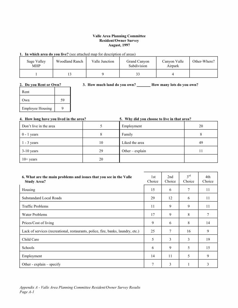
Appendix A - Valle Area Planning Committee Resident/Owner Survey Results Page A-1
Valle Area Planning Committee Resident/Owner Survey
August, 1997 1. In which area do you live? (see attached map for description of areas)
Sage Valley
MHP
Woodland Ranch
Valle Junction
Grand Canyon
Subdivision
Canyon Valle
Airpark
Other-Where?
1
13
9
33
4
2. Do you Rent or Own? 3. How much land do you own? How many lots do you own?
Rent
Own
59
Employee Housing
9
4. How long have you lived in the area? 5. Why did you choose to live in that area?
Don’t live in the area
5
Employment
20
0 - 1 years
8
Family
8
1 - 3 years
10
Liked the area
49
3-10 years
29
Other – explain
11
10+ years
20
6. What are the main problems and issues that you see in the Valle Study Area?
1st
Choice
2nd
Choice
3rd
Choice
4th
Choice Housing
15
6
7
11
Substandard Local Roads
29
12
6
11
Traffic Problems
11
9
9
11
Water Problems
17
9
8
7
Prices/Cost of living
9
6
8
14
Lack of services (recreational, restaurants, police, fire, banks, laundry, etc.)
25
7
16
9
Child Care
5
3
3
19
Schools
6
9
5
15
Employment
14
11
5
9
Other - explain – specify
7
3
1
3

Appendix A - Valle Area Planning Committee Resident/Owner Survey Results Page A-2
7. Which of the following do you think are important environmental concerns? Please rate each on a scale of 1-10 with 10 being the highest level of concern.
Air Quality
Vegetation
Water Quality
Wildlife Habitat
Dust
Noise
Light Pollution
Floodplain/Riparian Areas
National Park Protection
Litter/Trash Disposal
National Forest Protection
Overhead Utility lines
Preserving State Trust Land
Aesthetic Quality
Other, Explain
8. Which of the following do you think are important lifestyle concerns? How would rate the level of need? For those that are currently available, how would you rate the level of satisfaction?
NEED
SATISFACTION
Low
Medium
High
Low
Medium
High
Rental Housing
17
19
27
33
10
1
Home Ownership
6
22
27
22
18
12
Employment Opportunities
10
18
36
30
9
5
Seasonality of Employment
14
21
18
17
26
8
Medical/Dental Facilities
17
10
37
32
9
1
School Facilities
25
12
24
20
12
6
Law Enforcement Services
11
16
34
23
17
9
Fire Services
10
9
43
22
11
10
Phone Service
9
14
32
36
6
3
Houses of Worship
30
13
15
18
12
10
Recreation/Parks
33
14
12
15
8
6
Pedestrian Pathway
36
16
8
19
9
6
Transportation (Bus/Train)
19
19
28
24
11
2
Air Transportation
26
15
16
17
17
10
Domestic Water
8
12
43
17
19
11

Appendix A - Valle Area Planning Committee Resident/Owner Survey Results Page A-3
9. Which of the following uses do you think would be appropriate in Valle?
Yes
No
Single Family Homes
62
6
Apartments
42
24
Mobile Home Park
44
24
Condominium
26
42
Time Share
16
49
Neighborhood Retail
59
9
Bars
34
32
Museums
49
17
More Motel Rooms
37
28
More Restaurants
56
11
More Gift Shops
27
40
Junk Yards/ Salvage Yards
25
46
Travel Trailers for Employees
28
42
Day Care Facilities
55
12
Auto Repair Center
61
6
Laundry
64
3
Scenic Air Tour Operations
39
27
Commercial Air Service
38
28
Amusement Park
35
30
Tourist Oriented Recreation/Entertainment
45
21
Residential Oriented Recreation/Entertainment
55
11
Grand Canyon Railroad Spur to Valle
48
21
Shuttle Bus Staging Area for Travel to the Grand Canyon
49
19
Other – specify
7
10. Are there other uses (or Services) which are needed in the Study Area? YES 23 NO 27 If Yes, Explain: ________________________________________________________________________________________
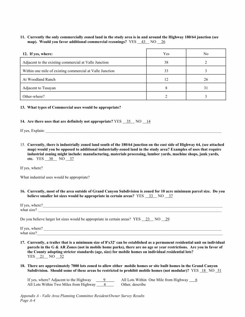
Appendix A - Valle Area Planning Committee Resident/Owner Survey Results Page A-4
11. Currently the only commercially zoned land in the study area is in and around the Highway 180/64 junction (see map). Would you favor additional commercial rezonings? YES 43 NO 26
12. If yes, where:
Yes
No
Adjacent to the existing commercial at Valle Junction
38
2
Within one mile of existing commercial at Valle Junction
33
3
At Woodland Ranch
12
26
Adjacent to Tusayan
8
31
Other-where?
2
3
13. What types of Commercial uses would be appropriate? 14. Are there uses that are definitely not appropriate? YES 35 NO 14 If yes, Explain: ________________________________________________________________________________________ 15. Currently, there is industrially zoned land south of the 180/64 junction on the east side of Highway 64, (see attached
map) would you be opposed to additional industrially-zoned land in the study area? Examples of uses that require industrial zoning might include: manufacturing, materials processing, lumber yards, machine shops, junk yards, etc. YES 30 NO 37
If yes, where? What industrial uses would be appropriate? 16. Currently, most of the area outside of Grand Canyon Subdivision is zoned for 10 acre minimum parcel size. Do you
believe smaller lot sizes would be appropriate in certain areas? YES 33 NO 37 If yes, where?__________________________________________________________________________________________ what size? ____________________________________________________________________________________________ Do you believe larger lot sizes would be appropriate in certain areas? YES 23 NO 29 If yes, where? _________________________________________________________________________________________ what size?_____________________________________________________________________________________________ 17. Currently, a trailer that is a minimum size of 8'x32' can be established as a permanent residential unit on individual
parcels in the G & AR Zones (not in mobile home parks), there are no age or year restrictions. Are you in favor of the County adopting stricter standards (age, size) for mobile homes on individual residential lots?
YES 21 NO 52 18. There are approximately 7000 lots zoned to allow either mobile homes or site built homes in the Grand Canyon
Subdivision. Should some of these areas be restricted to prohibit mobile homes (not modular)? YES 18 NO 51 If yes, where? Adjacent to the Highway 9 All Lots Within One Mile from Highway 6 All Lots Within Two Miles from Highway 4 Other, describe

Appendix A - Valle Area Planning Committee Resident/Owner Survey Results Page A-5
19. Do you believe Valle-Grand Canyon Subdivision and Woodland Ranch should support employee housing
opportunities for Tusayan business? YES 50 NO 19 If yes, where? Valle 38 Woodland Ranch 32 Other, specify____________________________________ 20. Are you in favor of specific guidelines to control architectural style, height, color of buildings, signs, and other site
improvements for commercial, multiple family, public and semi-public uses? (This would not apply to single family residential uses.) YES 31 NO 35
21. Currently many of the signs in Valle do not meet the county sign code requirements, some are grandfathered and
some are illegal. Do you think there should be stricter enforcement? 19 Or do you think the signs as they exist now are OK: 37 Or do you think there should be localized sign ordinance? 21
Suggestions _______________________________________________________________________________________ 22. Do you think that the night sky should be protected by limiting the amount and type of outdoor area lighting? YES 57 NO 14 23. Should the County be more active in the enforcing of zoning regulations? YES 29 NO 39 24. Do you feel there is a domestic animal control problem in the area? YES 32 NO 40 25. Do you think traffic on Highway 64 is a problem? YES 53 NO 13 North of the Junction YES 52 NO 7 South
of the Junction YES 42 NO 14 Do you think traffic on Highway 180 is a problem? YES 42 NO 23 Do you have any thoughts on how traffic conditions could be improved? 26. Do you think there is a problem created during the two mile stretch on Highway 180 where no fencing is provided? YES 39 NO 27 27. Do you think there is a need for a park in the Valle-Grand Canyon Subdivision area? YES 27 NO 41 If yes, where?___________________________________________ Do you think there is a need for a park in the Woodland Ranch Area? YES 13 NO 40 If yes, where?___________________________________ 28. Is there a need for a multi-purpose community center in Valle-Grand Canyon Subdivision ? YES 32 NO 32 If yes, where? In Woodland Ranch? YES 12 NO 40 If yes, where?______________________________________________ 29. Are there any special characteristic of the Study Area which should be preserved? YES 23 NO 19 If yes, what? 30. Do you support the SALE of state trust land for private development (not including grazing leases) YES 16 NO 51 If yes, what type? Commercial 9 Residential 10 Other comments: 31. Do you support the LEASE of state trust land for private development (not including grazing leases) YES 23 NO 43 If yes, what type? Commercial 12 Residential 7 Other comments: 32. Do you believe development and environmental protection can co-exist? YES 59 NO 10

Appendix A - Valle Area Planning Committee Resident/Owner Survey Results Page A-6
33. If your employment places you in contact with tourists to the Grand Canyon National Park, what, if any, comments, criticisms, or thoughts do you hear most frequently from them regarding their visit to the area?
Too crowded/ too many lines
33
Not enough parking
44
Too expensive
42
Lack of specific services, which ones
20
Other
6
34. Do you have any thoughts as to how Valle, as a community working together, can make a visitors experience more
pleasurable, more rewarding and a longer lasting experience? 35. Does the seasonality of the tourist season create any unique problems for the Valle area? YES 31 NO 26 Explain:___________________________________________________________________________________________ 36. Would increased tourism in the off-peak season (say, October through April) create any new problems for the
community of Valle? YES 10 NO 48 EXPLAIN _________________________________________________ 37. Do you feel temporary roadside vendors should be permitted? YES 25 NO 39 If yes, what locations are appropriate? Existing Commercial area of Valle 26 Highway frontage at Woodland Ranch 10 Other, specify______________ 38. The County Zoning Ordinance allows for some businesses to be conducted from homes or on residentially
developed properties through the Home Occupation and Cottage Industry provisions. Do you support this type of use? YES 57 NO 4
Comments________________________________________________________________________________________ 39. Is preservation of the natural vegetation important? YES 56 NO 5 40. If you own property, would you be willing to pay an additional tax to establish an elementary school district to serve
the community? YES 26 NO 38 Amount? ______________ 41. If you own property and live on an unpaved road would you be willing to pay a special district assessment to have it
improved and maintained? YES 31 NO 38 Amount? _____________ 42. If you own property, would you be willing to pay an additional tax to form a fire district? YES 31 NO 28 Amount? __________ 43. There are a number of proposals that could cause major change in the future of Valle. Please indicate if you are in

Appendix A - Valle Area Planning Committee Resident/Owner Survey Results Page A-7
favor or opposed to the following. Please check “not sure” if you have no opinion or if you do not have enough information.
In Favor
Opposed
Not Sure
Proposed Railroad spur from the Williams/Grand Canyon rail line to Tusayan
33
18
15
Proposed Tusayan Growth Alternatives:
2
6
15
Alternative A --No Action
22
12
22
Alternative B--Land Exchange Option 1 Canyon Forest Village 672 acres
5
38
20
Alternative C--Land Exchange Option 2 Canyon Forest Village Modified-380 acres
3
36
20
Alternative D--Townsite Act/Special Use Permit (Grand Canyon Improvement Assoc.)
9
27
24
Alternative E--Transportation/Federal Housing- (National Park housing and Transportation Staging Center developed on National Forest Land)
8
35
17
Valle as alternative to Canyon Forest Village and other alternatives as major staging area for facilities and transportation to Grand Canyon National Park
41
19
5
Other, specify:
1
1
44. Are there any other issues not covered in this survey that the Committee should be addressing? Explain:

Appendix A - Valle Area Planning Committee Resident/Owner Survey Results Page A-8
1. Ranch north of Valle - 1 Grand Canyon - 1 Grand Canyon Ranches - 4 Bull Basin - 2 Work in Valle - 1 Flagstaff - 2
3A. 0AC – 2 5AC – 1 14AC – 1 41AC – 2
1AC – 6 7AC – 3 15AC – 1 80AC – 3 1.5AC – 1 10AC – 2 20AC – 3 100AC – 1 1.89AC – 1 11AC – 2 40AC – 5 120AC – 2 2AC – 6
3B. 1 lot - 14 4 lots - 2 16 lots – 2
2 lots - 10 5 lots - 1 20 lots – 2 3 lots - 4 7 lots – 3 lots of lots – 2
5. 1. Only place to buy land
2. lack of people 3. I don’t choose, it’s where my employer has housing 4. Far from junction, few neighbors, residential zoning, wildlife, scenery, stars. 5. Vacation, weekends, retirement someday. 6. It’s a chance to live as I choose without employer’s imposing rules for you in your
own home. 7. Admired the way-of-life that western living used to offer, in the “good old days”. 8. Bought business 9. Lack of affordable housing (or any housing for that matter) in Tusayan 10. Raised in area, third generation native 11. Stupidity 12. I didn’t want the restrictions of city life.
6. 1. Affordable phone service - Woodland Ranch 2. Taxation without representation 3. No grocery store, no restaurants, no cheap phones 4. I think any implementation of services, housing, etc., should be closely scrutinized
to prevent overdevelopment and making a nice area undesirable. 5. Phone service 6. Cost of APS (electrical) hook-up 7. Phones 8. An obvious imbalance between potent commercial interests vs. individuals’ needs for consideration. 9. Availability of basic utilities i.e. water, electricity 10. More county consideration with permits - building, septic, etc.

Appendix A - Valle Area Planning Committee Resident/Owner Survey Results Page A-9
11. Electrical Power 12. Lack of services for taxes paid i.e. police, roads, etc. 13. Sage Valley MHP owners sticking their nose in private owners business and not maintaining
the road properly to their trailer park. Recently put a large mound of dirt and large rocks across main road, hazardous to vehicles.
14. Electrical power 15. Shortage of most everything 16. Stores
7. Air Quality Water Quality Dust Light Pollution National Park Protection 1 7 6 6 9 3 2 3 3 2 0 3 3 1 1 6 7 3 4 0 0 0 5 5 5 7 7 8 14 8 6 2 3 2 4 0 7 2 1 1 3 2 8 11 3 10 4 4 9 3 3 3 9 5 10 27 31 20 16 21 National Forest Protection Preserving STL Vegetation Wildlife Habitat Noise 1 2 4 2 3 8 2 3 2 2 2 2 3 3 1 3 1 2 4 0 2 3 4 4 5 7 10 6 7 8 6 5 2 3 5 5 7 8 3 0 4 8 8 9 10 6 6 7 9 7 4 5 3 5 10 23 21 21 26 16
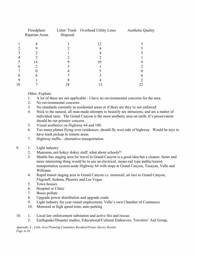
Appendix A - Valle Area Planning Committee Resident/Owner Survey Results Page A-10
Floodplain/ Litter/ Trash Overhead Utility Lines Aesthetic Quality Riparian Areas Disposal 1 4 1 12 3 2 9 2 4 5 3 2 1 4 5 4 3 2 2 1 5 14 9 10 4 6 2 5 1 2 7 0 4 5 0 8 6 7 3 6 9 1 8 4 2 10 7 24 12 22
Other, Explain: 1. A lot of these are not applicable - I have no environmental concerns for the area. 2. No environmental concerns 3. No standards currently in residential areas or if there are they’re not enforced 4. Stick to the natural, all man-made attempts to beautify are intrusions, and are a matter of
individual taste. The Grand Canyon is the most aesthetic area on earth. It’s preservation should be our primary concern.
5. Visual aesthetics on Highway 64 and 180. 6. Too many planes flying over residences, should fly west side of highway. Would be nice to
have trash pickup in remote areas. 7. Highway traffic - alternative transportation.
9. 1. Light industry
2. Museums, not hokey dokey stuff, what about schools!! 3. Shuttle bus staging area for travel to Grand Canyon is a good idea but a cleaner, faster and
more interesting thing would be to use an electrical, mono-rail type public/tourist transportation system aside Highway 64 with stops at Grand Canyon, Tusayan, Valle and Williams
4. Rapid transit staging area to Grand Canyon i.e. monorail, air taxi to Grand Canyon, Flagstaff, Sedona, Phoenix and Las Vegas.
5. Town houses 6. Hospital or Clinic 7. Buses pollute 8. Upgrade power distribution and upgrade roads 9. Light industry for year round employment, Valle’s own Chamber of Commerce 10. Monorail or high speed train, auto parking
10. 1. Local law enforcement substation and active fire and rescue
2. Earthquake/Disaster studies, Educational/Cultural Endeavors, Travelers’ Aid Group,

Appendix A - Valle Area Planning Committee Resident/Owner Survey Results Page A-11
Library, Bona fide Observatory Sites 3. Post Office, Grocery and Pharmacy, paved roads, piped water service 4. hardware, lumber - building material store 5. Industrial Park, trade free zone at airport 6. Grocery/drug store 7. Bank, Post Office, General Store 8. Supermarket 9. Power to Grand Canyon Subdivision and pave major roads in area 10. Banking 11. Decent reasonable phone service, doctor and phone services 12. Grocer 13. Video store, supermarket 14. Maintained roads, take power further from core of Valle to encourage growth in outlying
areas 15. road maintenance, power and phone 16. More jobs with better pay 17. Banking services 18. Dump transfer station 19. Most everything, especially in Valle, grows 20. Phone service, road maintenance, general/hardware store with reasonable prices, fast food,
phone and cable 11. 1. Very important for Valle’s growth. There was plenty of commercial property in Valle until
Planning and Zoning arbitrarily changed it in about 1972, 1973 2. After development of existing commercially zoned land 3. Areas along highway
12. 1. Open up zoning well-down highway 64 and 180, allow persons to try businesses further than
only one mile from junction. Encourage cottage industries in residences. Don’t hide behind the words “spot zoning”, Think More!
2. On or adjacent to the airport 3. Up 180 toward Flagstaff and 64 to Williams 4. From Williams to Tusayan along highway
13. Grocery - 5 Ostrich farms Post Office - 2
Commercial farming Swap meet – 1 Motels - 2 Mini-storage - 2 Junk yard – 1 Auto Repair - 4 General hardware - 3 Any services would be a help – 2 Golf Course Entrepreneurial business - 1 Housing Gas Station - 2 Recreational farming Feed Store – 2 Laundry - 3 Phones Bar – 1 Gift Shops - 1 Recreation/entertainment - 3 Tourist related, service related Restaurant - 4 Retail serving locals and local employment – 5

Appendix A - Valle Area Planning Committee Resident/Owner Survey Results Page A-12
14. 1. No “heavy” commercial at Woodland - no strip malls, no junk yards 2. Commercial uses that are strictly tourist oriented unless they provide substantial
employment opportunities for locals. 3. Junk yards - 3 4. Big industrial pollution causing (noise, air, ground) business, not too many motels -
leave them in Tusayan 5. No porno shops, chain restaurants, junk yards 6. Attractions - this should be a residential community as much as possible 7. Hazardous waste disposal - 2 8. Roadside vendors 9. Any business that creates additions to traffic (trucking) with current poor conditions
10. Dumping grounds for armaments, nuclear waste and all similar abominations 11. Environmentally unclean or hazardous 12. Too much of anything 13. No factories 14. strip mall - 2 15. low income housing - 2 16. Any industry not compatible with residential 17. No shopping malls, condos, Wal-mart 18. Bays, jails, heavy industry 19. No mining or quarries - 2 20. It wouldn’t be good to have a junk yard next to the highway. 21. Gift shops 22. Hazardous materials, heavy industry 23. Heavy industrial, crime involving business, 24. Bars - 7
15A. 1. Woodland Ranch area 2. Downtown 3. I’d be opposed, I’m for as little commercial development in Valle as possible. 4. As long as they are out of sight of 180 and 64 and not in or in sight of residential areas 5. North of 180/64 and west of 64 6. Highgrove 7. Everywhere - 4 8. Anywhere within 5 miles of homes or restaurants 9. Any industrial use should be segregated to areas of like function. An industrial complex
adjacent to the airport and either out of sight from the highway or compliant to strict aesthetic standards would be acceptable
10. Valle area - 4 11. Industrial park west of Valle should be zoned CG-10,000, section 15 or 21, next to Grand
Canyon Railroad 12. Not spread all over 13. Yes, I would be opposed, question is misleading

Appendix A - Valle Area Planning Committee Resident/Owner Survey Results Page A-13
15B. 1. Any industrial use that is environmentally conscious and provides service to the community 2. Only those which would generate jobs for the community 3. Anything that could be defined as a Αclean non-polluting≅ business. This industrialization
would provide diversified employment to the area 4. Electronics, assembly, distribution, bottling, micro brewery 5. Lumber yards, junk yards, manufacturing 6. Lumber yard, machine shop 7. None - 4 8. Dump, recycling 9. Only those that compliment and blend aesthetically 10. Lumber yard, machine shop, junk yard, auto repair 11. Recycling 12. Ha 13. Lumber yard, junk yard 14. A big store
16A. 1. Woodland - 2.5AC minimum, 5AC - 3, 1-5AC, 2-3AC,
2. We need to keep a mix - 2 3. I think this has been zoned well for the purpose of town and community living, not for
tourism, which is just as well 4. 2-5AC, .25-.5AC, 5AC - 3, 3-5AC 5. Generally speaking, I believe that nothing in the Valle area should be smaller than one acre.
How large some parcels should be, could be dictated by the specific us of the parcels. 6. Valle - 2AC - 2, 3AC 7. By junction of 180/64, 5AC, 2-4AC 8. Close to the highways - 1AC 9. Grand Canyon Ranches, 5AC - 2 10. County zoning has already set standards for subdivision 11. There are enough small lots. 12. Grand Canyon Valle airport area, 1AC 13. 2AC within 3 miles of highway 14. Further along 64 or 180, 2.5AC 15. Back from the road, different sizes
16B. 1. 40AC, 1+AC, 5AC
2. Rural areas where residents choose to keep the lot sizes bigger 3. Far back in Grand Canyon Subdivision, 20 - 40AC 4. Valle airport, 1AC 5. Grand Canyon subdivision, 10AC 6. 1 mile back from highways, 3+AC, 3-4+AC 7. If people wanted more land, to be combined at a single ownership 8. All over - 2 9. Mixed - 2

Appendix A - Valle Area Planning Committee Resident/Owner Survey Results Page A-14
17. 1. That would make a lot of people homeless, it’s discrimination. 2. This isn’t Flagstaff, that’s why we’re here. 3. The county should enforce existing laws and regulations before considering any further
regulation. 4. Mixed 5. On highway especially
18. 1. All new settlements
2. There are very few places where persons of limited income can live. Mobile homes are vital to their existence. Anywhere their property is located.
3. Need better definition of mobile home. Some mobile home are nicer than some existing houses.
4. Do not restrict peoples’ right to own their own affordable housing please. 5. Not side to side anywhere. 6. All lots - 2 7. 180, 1 mile down, right side 8. But should meet high standards where visible
19. 1. Tusayan businesses should provide decent family units, not mobile homes, with the
necessary services (schools, parks, retail). Space in between. Sending their employees south is okay, as long as they provide (or help provide) decent housing (and those things that accompany decent housing i.e. good roads, retail, day care).
2. In Tusayan, build more apartments to rent not more than 1 or 2 miles out of town. 3. I don’t believe that housing is appropriate, I feel that it is a non-secure non-permanent
situation and when people are in that position they are less likely to support community action and development.
4. I find this question very distasteful! It implies disdain for other communities (Tusayan). People need housing. People should be able to live anywhere they want and can afford. If we want Valle to grow, we cannot be inhospitable to people, nor can we be prejudiced towards people who work in other communities.
5. Should be in Tusayan. 6. Woodland Ranch should be agricultural residential private owners only, no trailer parks,
housing developments. 7. If kept to high standards
21. 1. Standardize
2. A specific height and size 3. The signs now aren’t bad but they should not allow them to be over a certain height and size. 4. No billboards, no lights after 10 pm. 5. Let the Valle area planning committee decide. 6. Signs are vital to local businesses. While some were constructed years ago, the messages are
current and for businesses elsewhere - perhaps there should be a special committee formed to re-evaluate the inequities that exist in the laws and in the area.

Appendix A - Valle Area Planning Committee Resident/Owner Survey Results Page A-15
7. Current rules are too restrictive for rural, tourist oriented businesses. 8. This is America, people like it - Flintstones probably does not meet code but look how many
visitors take pictures of themselves with the signs. 9. Comply with County sign codes 10. County codes should be complied with. 11. More relaxed 12. Make signage easier so the businesses can grow. 13. Do as required in Tusayan and Williams 14. Airport needs better signage from the north 15. Leave it alone - 3 16. Standardize with exceptions for need 17. Let people earn a living 18. We need to be able to do whatever brings business in
25. 1. Signs announcing side roads, no passing lines, speed-up lanes, left turn lanes, widen the road - 4 lanes, protection from people turning in/out of Woodland Ranch (and other side roads off of 64)
2. Target tourists 3. Passing lanes on Highway 64 4. Widen 64 5. Traffic has gotten better since people are using their headlights but maybe have passing
lanes. People just need to learn how to drive! 6. More law enforcement, more signs (wildlife, weather conditions) 7. Widen both highways, more speed enforcement 8. Four lane highway 64 - build turning lanes at Woodland Ranch and other major side roads 9. Four lanes at least from junction north to Grand Canyon or provide some passing lanes 10. Make highway 64 four lanes - 5 11. More enforcement of speed - 7 12. Turn out lanes at Woodland Ranch 13. Widen roads ( Hwy 64), put in turn lanes for all residentially zoned areas. 14. Widen all highways all the way 15. Put bus or rapid transit center in Valle to shuttle tourists to Grand Canyon. 16. More passing zones with adequate signage 17. Make highway 64 a gateway highway, it’s the key to improving Grand Canyon, Tusayan,
Valle, Williams 18. Passing lanes on both 180 and 64, business turn lanes, more pronounced signage for speed,
passing and no passing zones 19. More pull-outs where slow traffic could be passed safely 20. Back fill the Grand Canyon - just kidding 21. There should be a stop light or stop sign in Valle junction to slow tourists down, it is very
dangerous due to passing lines and turning lanes. 22. Widen existing roads with more turnouts and roadside stops for tourists taking pictures 23. Make left turn lane at Woodland Ranch and Highgrove for safety of those turning off the
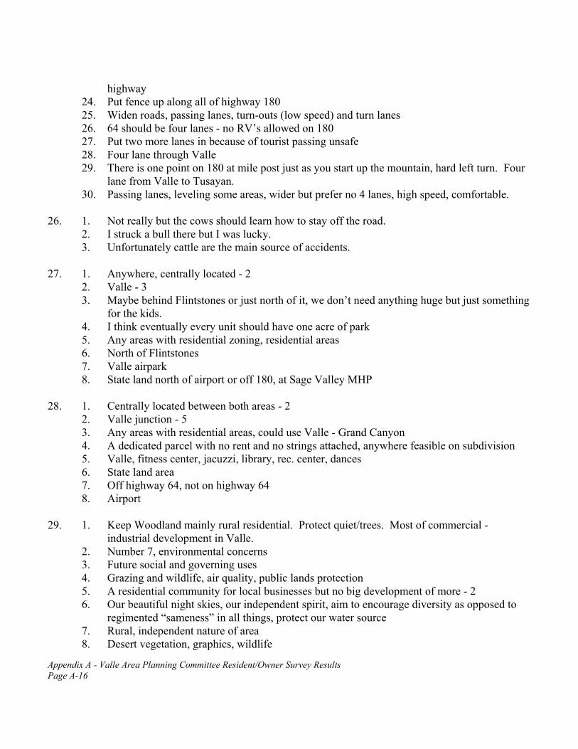
Appendix A - Valle Area Planning Committee Resident/Owner Survey Results Page A-16
highway 24. Put fence up along all of highway 180 25. Widen roads, passing lanes, turn-outs (low speed) and turn lanes 26. 64 should be four lanes - no RV’s allowed on 180 27. Put two more lanes in because of tourist passing unsafe 28. Four lane through Valle 29. There is one point on 180 at mile post just as you start up the mountain, hard left turn. Four
lane from Valle to Tusayan. 30. Passing lanes, leveling some areas, wider but prefer no 4 lanes, high speed, comfortable.
26. 1. Not really but the cows should learn how to stay off the road.
2. I struck a bull there but I was lucky. 3. Unfortunately cattle are the main source of accidents.
27. 1. Anywhere, centrally located - 2 2. Valle - 3 3. Maybe behind Flintstones or just north of it, we don’t need anything huge but just something
for the kids. 4. I think eventually every unit should have one acre of park 5. Any areas with residential zoning, residential areas 6. North of Flintstones 7. Valle airpark 8. State land north of airport or off 180, at Sage Valley MHP
28. 1. Centrally located between both areas - 2
2. Valle junction - 5 3. Any areas with residential areas, could use Valle - Grand Canyon 4. A dedicated parcel with no rent and no strings attached, anywhere feasible on subdivision 5. Valle, fitness center, jacuzzi, library, rec. center, dances 6. State land area 7. Off highway 64, not on highway 64 8. Airport
29. 1. Keep Woodland mainly rural residential. Protect quiet/trees. Most of commercial -
industrial development in Valle. 2. Number 7, environmental concerns 3. Future social and governing uses 4. Grazing and wildlife, air quality, public lands protection 5. A residential community for local businesses but no big development of more - 2 6. Our beautiful night skies, our independent spirit, aim to encourage diversity as opposed to
regimented “sameness” in all things, protect our water source 7. Rural, independent nature of area 8. Desert vegetation, graphics, wildlife

Appendix A - Valle Area Planning Committee Resident/Owner Survey Results Page A-17
9. Its open and harmonious space should be protected, don’t let Valle become an eyesore, mishmash gateway to the Grand Canyon.
10. Open Space 11. Any state land and grazing rights 12. Leave the last four miles from highway of Woodland Ranch and Highgrove rural, as it is to
the individual owners needs as they want it. Country people want to be left alone. 13. Variety - differences 14. Bedrock and rock shop should be combined 15. Wildlife - 3 16. Individualism 17. Lots of different styles 18. Peace and quiet 19. The deer and other animals
30. 1. State Lands should be kept for future generations 31. 1. But only close to the highway within a mile
2. Better than sale 33. 1. I’ve heard all of these from tourists, but mostly I hear criticism of more unbridled
development in a beautiful remote area - they come here for the Grand Canyon, not the tourist traps.
2. a. Prices of rooms, fast food chains, car repairs/gasoline and gifts at Canyon are all too high b. Particularly during peak season: not enough rooms, necessitating advance reservations -
some nights people had to travel to Kingman for a room. c. Were refused mule trips down the Grand Canyon because the list was prepared so far in
advance and tourists didn’t realize they had to make advance reservations 3. Auto repair 4. Too commercial 5. None, they make it possible for me to have a job 6. Banks, clothes stores (K-mart, Wal-mart), food, movies, child activities 7. Nothing to do at night - 2 8. General store 9. Park rangers are unfriendly
34. 1. Make tourists want to come back
2. Lower motel rates 3. If we looked like a town, operated like a town, provided services for locals, then tourists are
more attracted to the area, they want to feel at home, not like it’s a gas/eat/sleep stop-over. 4. Keep things aesthetic and under scrutiny 5. Clean up area. Plant native trees. 6. Create an environment for tourists to have experiences/opportunities which are unique to
Valle, and an addition to their Grand Canyon experience.

Appendix A - Valle Area Planning Committee Resident/Owner Survey Results Page A-18
7. Be congenial, helpful and genuinely concerned about tourists needs. Contribute willingly to their education about the Grand Canyon. Provide assistance when they are stranded due to misfortunes as they travel.
8. Reasonably priced lodging, restaurants, entertainment, shopping and transportation to and from the Grand Canyon.
9. More to do - 2 10. Have a welcome center with professionally trained staff 11. Improve highway 12. 90% of locals treat tourists as if they have the plague - without the tourists they wouldn’t be
here 13. Be a little more pleasant 14. Lower costs 15. More businesses 16. Those of us who work with them should be as nice and helpful to them as possible 17. Make Valle an inviting place to return to from the Canyon 18. More western entertainment and recreation after a long day in the Canyon. Make them want
to stay a week in Valle because of its central location to Northern Arizona. 19. Have some public entertainment, bars, movies, restaurants 20. More restaurant choices 21. Friendly waiters - 2 22. Ease of access, maintain looks, fair prices, more of everything available 23. To be more friendly to the tourists - 2
35. 1. Makes for a deadly highway 180 and 64
2. Many more bad drivers 3. Hard to find good part-time employees 4. We all need winter to recover , I think 5. Loss of business, loss of working hours for employees 6. The junction of 64 and 180 is very scary as is the rest of those highways 7. Job availability 8. Number of vehicles and trash 9. In winter: less income for both employers and employees makes for greater personal
problems 10. Volume of business to support #34 above, in off season. 11. No work/money - 9 12. Housing for seasonal employees 13. High unemployment in winter 14. No income or jobs off season 15. It practically dies in winter, but is too busy in summer for what is here 16. Employees are turned over too quickly prohibiting unification of people 17. It’s getting shorter and shorter as long as there is not a lot of snow. 18. Most people can’t make a living in the winter 19. 3 months down time
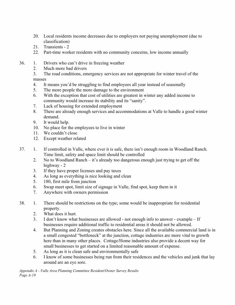
Appendix A - Valle Area Planning Committee Resident/Owner Survey Results Page A-19
20. Local residents income decreases due to employers not paying unemployment (due to classification)
21. Transients - 2 22. Part-time worker residents with no community concerns, low income annually
36. 1. Drivers who can’t drive in freezing weather
2. Much more bad drivers 3. The road conditions, emergency services are not appropriate for winter travel of the
masses 4. It means you’d be struggling to find employees all year instead of seasonally 5. The more people the more damage to the environment 6. With the exception that cost of utilities are greatest in winter any added income to
community would increase its stability and its “sanity”. 7. Lack of housing for extended employment 8. There are already enough services and accommodations at Valle to handle a good winter
demand. 9. It would help. 10. No place for the employees to live in winter 11. We couldn’t close 12. Except weather related
37. 1. If controlled in Valle, where ever it is safe, there isn’t enough room in Woodland Ranch.
Time limit, safety and space limit should be controlled 2. No to Woodland Ranch – it’s already too dangerous enough just trying to get off the
highway - 2 3. If they have proper licenses and pay taxes 4. As long as everything is nice looking and clean 5. 180, first mile from junction 6. Swap meet spot, limit size of signage in Valle, find spot, keep them in it 7. Anywhere with owners permission
38. 1. There should be restrictions on the type; some would be inappropriate for residential
property. 2. What does it hurt. 3. I don’t know what businesses are allowed - not enough info to answer - example – If
businesses require additional traffic to residential areas it should not be allowed. 4. But Planning and Zoning creates obstacles here. Since all the available commercial land is in
a small congested “bottleneck” at the junction, cottage industries are more vital to growth here than in many other places. Cottage/Home industries also provide a decent way for small businesses to get started on a limited reasonable amount of expense.
5. As long as it is clean safe and environmentally safe 6. I know of some businesses being run from their residences and the vehicles and junk that lay
around are an eye sore.

Appendix A - Valle Area Planning Committee Resident/Owner Survey Results Page A-20
7. Only certain types of businesses 8. No outlet operations 9. It depends on the type of industry, but generally - no 10. As long as yards are kept up 11. Not a gift store, must manufacture items sold - 4 12. No, unless held to high standards
40. 1. Yes, but I would not be willing to continue paying taxes to the Williams District and taxes to
the Valle schools. I would support trying to change the district lines, although this may be very difficult to do.
2. I don’t own but I’d still pay since my employers housing is out here 3. As much as needed, not to exceed 2-5% of my existing property taxes 4. As much as we pay to Williams for a school most of the kids in the area don’t attend; we
should be able to use those taxes for a new school here 5. Use the money currently given to Williams at least 6. match the amount already paid to Williams 7. Give us the services our tax dollars entitle us to before any consideration of more taxes 8. 5% increase 9. .25% or take Williams taxes and apply them to Valle instead 10. $350.00 11. $200.00/year 12. open
41. 1. I like the roads the way they are.
2. Depends on cost of improvement. 3. $1.00/day 4. $100.00/month 5. $350 6. I already pay taxes 7. None of the taxes we pay now are being used for our benefit. 8. 1% increase 9. .5% 10. $200.00/year 11. open 12. People have been paying taxes on their property for years already with no road
improvement. The state should repair anyway. 42. 1. Only if we, at Woodland, could benefit from its services, i.e. centrally located
2. An appropriate amount 3. We already pay a fire district tax to Williams that would most likely never be used here -
take that tax and give us a fire district here 4. 2% increase, take the funds that I give to Williams and give them to Valle 5. .25% or take county tax and apply to Valle

Appendix A - Valle Area Planning Committee Resident/Owner Survey Results Page A-21
6. Open 44. 1. I think the water aquifer we sit on is critical to the proper growth of the area. I think that we
should refrain from allowing anyone or any plan (such as CFV) from sinking wells, that does not have the immediate local community as its first concern. No water, no growth.
2. a. A possible truck route off highway 64 - for travel to the Grand Canyon b. Signage on highway 64 - so that tourists can understand traffic laws - speed - no pass
zones, perhaps move signs (international instead of English language) 3. a. An inherent problem of this survey exists in the fact that only persons residing in the area
were “properly” informed of this important process. All owners of property in the area could have been (and still could be) informed. A simple, one-page notification could be included with tax notices. I believe it is wrongful to create legal guidelines for many owners, in such a huge land area, and not find a way to inform them of what is occurring.
b. Fire district vs. private volunteer fire department was not discussed enough 4. I strongly believe that Valle, and not Tusayan or CFV should be the prime choice for growth
as it has the least impact on the forests, water, traffic and the environment. 5. a. Does Valle intend to become another Tusayan only with some foresight on planned
development? Is Valle’s interest in future development 100% tourist oriented? If so then commercially develop, develop, develop! Reap those tourist dollars in! Inconsistent as they may be.
b. Or is the future development of Valle to be a stable, local, residential community with all the community services and small light industrial businesses to help support this community outside of the tourist dollar? It seems that these are the two primary questions being asked here based on the survey. Having lived in this area for years (15+) I have watched what little “sense of community” there was, deteriorate in the Tusayan area. I would hate to see this same developmental attitude flourish in Valle. Most people have the emotional need to belong and that’s hard to achieve in an environment that treasures the almighty tourist dollar with little regard for the people who helped put the money in their hands.
6. Why doesn’t APS service the remote areas better. Even in remote Africa and Turkey, power lines are run to a single home miles from anywhere.
7. Press for county to provide Valle area with services it provides other population centers, i.e. police protection, road maintenance
8. Making use of the tax base for base area instead of making it hard for private homes 9. No cutting forests, trees to build commercial properties, we want our trees 10. Become our own incorporated town. 11. Working with the power and phone to add more services to the community! This will help
develop Valle and give more alternatives. 12. No water for more hotels, not enough water for lots of use with no reclamation plan 13. a. phone and utilities in Woodland Ranch, need more input
b. dump transfer station c. water
14. Concerning #43, do not pay so much attention to what’s going on in another community. Do

Appendix A - Valle Area Planning Committee Resident/Owner Survey Results Page A-22
those things to counteract. Invite more motels and quality eating establishments, recreation center that is guest oriented, i.e. putt putt golf, swimming pool, 18 hole golf course, much more. Keeping your tax base lower than the rest is a real plus. Do not down grade your community or anyone in it. Stop calling them “damn tourists” they are our guests. Be as accommodating as you would to a guest in your home. Canyon Forest Village will happen, stop beating your head. Just as this community has a right to do, so do they.
15. Water and sewer distribution, name change, boundaries, promotions 16. Consider changing Valle name to “Grand Canyon Valle”