Using Weather & NOTAMs in the Trip Planning Process . Intensity or Proximity Descriptor...
53
Using Weather & NOTAMs in the Trip Planning Process PRESENTED BY: Chris Algee Brian Boothe Schedulers & Dispatchers Conference | New Orleans, LA | January 14-17, 2014 Wednesday, January 15 th 2014 3:30 p.m. – 5:00 p.m.
Transcript of Using Weather & NOTAMs in the Trip Planning Process . Intensity or Proximity Descriptor...
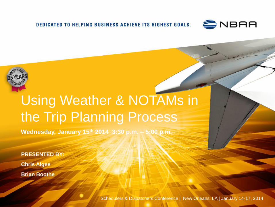
Using Weather & NOTAMs in
the Trip Planning Process
PRESENTED BY:
Chris Algee
Brian Boothe
Schedulers & Dispatchers Conference | New Orleans, LA | January 14-17, 2014
Wednesday, January 15th 2014 3:30 p.m. – 5:00 p.m.
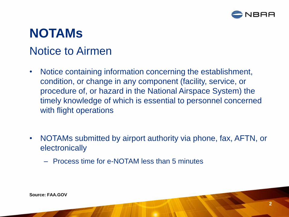
NOTAMs
• Notice containing information concerning the establishment,
condition, or change in any component (facility, service, or
procedure of, or hazard in the National Airspace System) the
timely knowledge of which is essential to personnel concerned
with flight operations
• NOTAMs submitted by airport authority via phone, fax, AFTN, or
electronically
– Process time for e-NOTAM less than 5 minutes
Notice to Airmen
Source: FAA.GOV
2
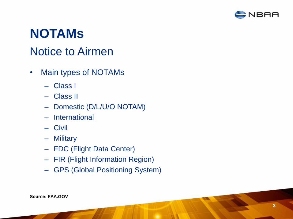
NOTAMs
• Main types of NOTAMs
– Class I
– Class II
– Domestic (D/L/U/O NOTAM)
– International
– Civil
– Military
– FDC (Flight Data Center)
– FIR (Flight Information Region)
– GPS (Global Positioning System)
Notice to Airmen
Source: FAA.GOV
3
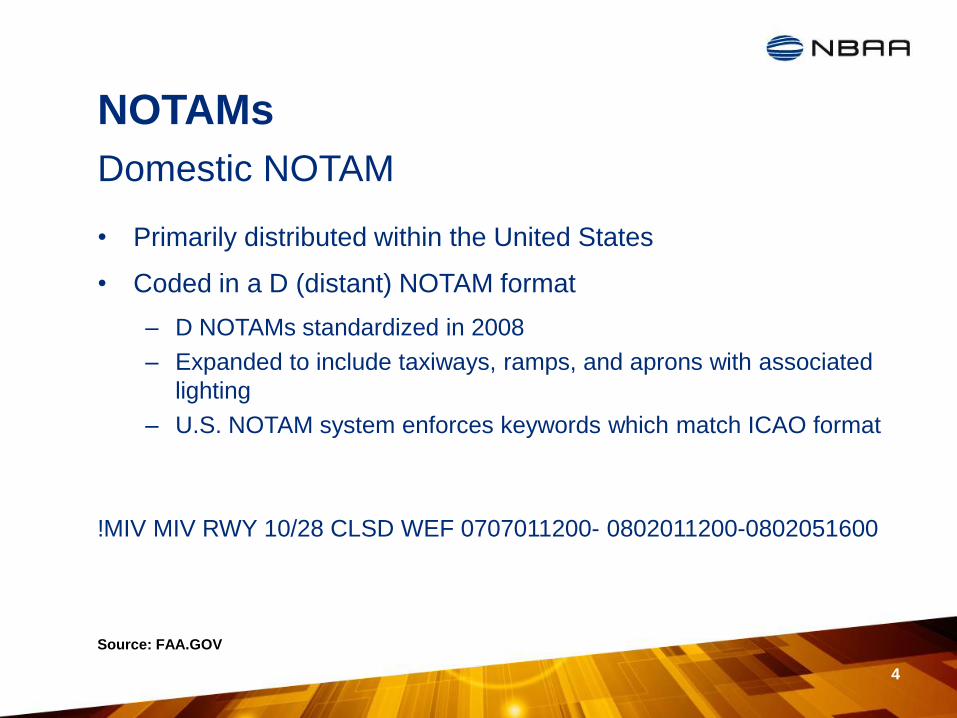
NOTAMs
• Primarily distributed within the United States
• Coded in a D (distant) NOTAM format
– D NOTAMs standardized in 2008
– Expanded to include taxiways, ramps, and aprons with associated
lighting
– U.S. NOTAM system enforces keywords which match ICAO format
!MIV MIV RWY 10/28 CLSD WEF 0707011200- 0802011200-0802051600
Domestic NOTAM
Source: FAA.GOV
4
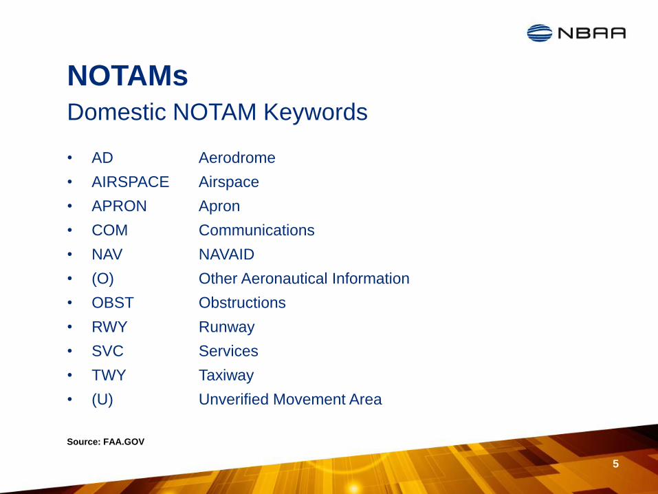
NOTAMs
5
Domestic NOTAM Keywords
Source: FAA.GOV
• AD Aerodrome
• AIRSPACE Airspace
• APRON Apron
• COM Communications
• NAV NAVAID
• (O) Other Aeronautical Information
• OBST Obstructions
• RWY Runway
• SVC Services
• TWY Taxiway
• (U) Unverified Movement Area
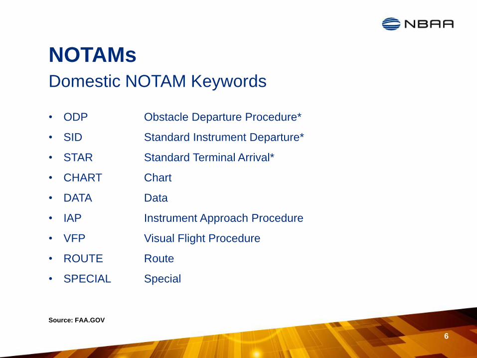
NOTAMs
• ODP Obstacle Departure Procedure*
• SID Standard Instrument Departure*
• STAR Standard Terminal Arrival*
• CHART Chart
• DATA Data
• IAP Instrument Approach Procedure
• VFP Visual Flight Procedure
• ROUTE Route
• SPECIAL Special
6
Domestic NOTAM Keywords
Source: FAA.GOV

NOTAMs
• AP Airport
• APCH Approach
• ATIS Automatic Terminal
Information Service
• AWY Airway
• FDC Flight Data Center
• FREQ Frequency
• GP Glide Path
• IAF Initial Approach Fix
• IF Intermediate Fix
• ILS Instrument Landing System
• LGTD Lighted
• LIRL Low Intensity Runway Lights
• LLZ Localizer
7
Common NOTAM Contractions
Source: http://www.nbaa.org/ops/airspace/issues/notam-realignment/200710_NOTAM_Brochure.pdf
• NA Not Authorized
• NMR Nautical Mile Radius
• OTS Out of Service
• RCLL Runway Center Line Lights
• RQRD Required
• RTS Return to Service
• RVR Runway Visual Range
• RWY Runway
• TGL Touch-and-Go Landings
• TWR Airport Control Tower
• TWY Taxiway
• WEF With Effect From or
Effective From
• WIE With Immediate Effect or
Effective Immediately
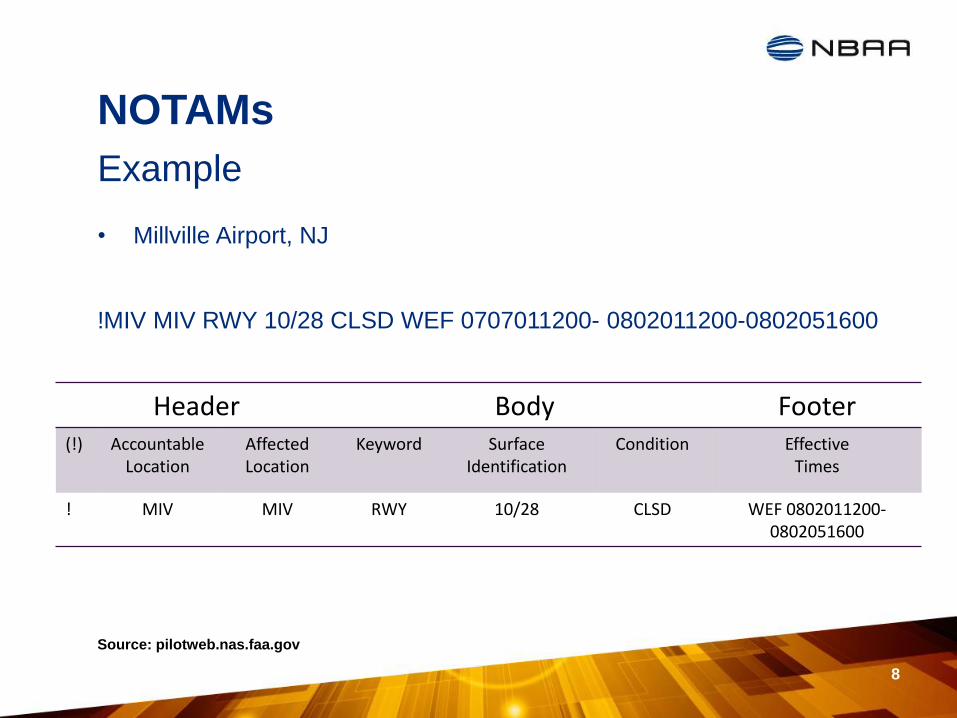
NOTAMs
• Millville Airport, NJ
!MIV MIV RWY 10/28 CLSD WEF 0707011200- 0802011200-0802051600
8
Example
Source: pilotweb.nas.faa.gov
Header Body Footer (!) Accountable
Location Affected Location
Keyword Surface Identification
Condition Effective Times
! MIV MIV RWY 10/28 CLSD WEF 0802011200- 0802051600
NOTAMs
• Teterboro Airport, NJ
!TEB 11/141 TEB AD WILDLIFE HAZARD DEER SIGHTING SW SIDE
1311141912-1311292000
9
Example
Source: pilotweb.nas.faa.gov
Header Body Footer (!) Accountable
Location Affected Location
Keyword Condition REASON Effective Times
! TEB TEB AD WILDLIFE HAZARD
DEER SIGHTING SW SIDE
1311141912-1311292000
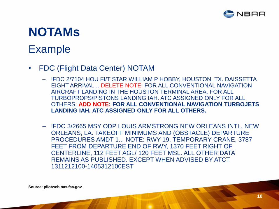
NOTAMs
• FDC (Flight Data Center) NOTAM
– !FDC 2/7104 HOU FI/T STAR WILLIAM P HOBBY, HOUSTON, TX. DAISSETTA EIGHT ARRIVAL... DELETE NOTE: FOR ALL CONVENTIONAL NAVIGATION AIRCRAFT LANDING IN THE HOUSTON TERMINAL AREA. FOR ALL TURBOPROPS/PISTONS LANDING IAH. ATC ASSIGNED ONLY FOR ALL OTHERS. ADD NOTE: FOR ALL CONVENTIONAL NAVIGATION TURBOJETS LANDING IAH. ATC ASSIGNED ONLY FOR ALL OTHERS.
– !FDC 3/2665 MSY ODP LOUIS ARMSTRONG NEW ORLEANS INTL, NEW ORLEANS, LA. TAKEOFF MINIMUMS AND (OBSTACLE) DEPARTURE PROCEDURES AMDT 1... NOTE: RWY 19, TEMPORARY CRANE, 3787 FEET FROM DEPARTURE END OF RWY, 1370 FEET RIGHT OF CENTERLINE, 112 FEET AGL/ 120 FEET MSL. ALL OTHER DATA REMAINS AS PUBLISHED. EXCEPT WHEN ADVISED BY ATCT. 1311212100-1405312100EST
10
Example
Source: pilotweb.nas.faa.gov

NOTAMs
• Q (Qualifier) Line
– Eight Sections separated by a stroke
– Coded line that shows all relevant information contained in the
NOTAM
A3900/13 NOTAMN
Q) EGTT/QFALC/IV/NBO/A /000/999/5152N00022W005
A) EGGW
B) 1312252300
C) 1312260600
E) AD CLOSED
International NOTAMs
Source: FAA.GOV
11

NOTAMs
12
Digital NOTAMs
Source: http://www.aixm.aero/public/standard_page/ind_aeronavdata.html
ED-99/DO-272 Compliant AIXM 5.1 output from AeroNavData's AMDB
Database displayed in Snowflake Software's ATM Viewer highlighting a
Taxiway Closure at KBDL
• A dataset made available through digital services
• Same information as standard NOTAM
• Can be easily visualized on GIS platforms
• Will be able to be pulled in through aircraft FMS
• Interested in finding out more about the NOTAM system and upcoming changes?
– NOTAM Changes on the Horizon
– Thursday 315-445 pm
– Room215
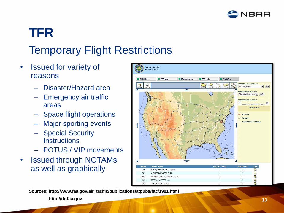
TFR
13
Temporary Flight Restrictions
Sources: http://www.faa.gov/air_traffic/publications/atpubs/fac/1901.html
http://tfr.faa.gov
• Issued for variety of reasons
– Disaster/Hazard area
– Emergency air traffic areas
– Space flight operations
– Major sporting events
– Special Security Instructions
– POTUS / VIP movements
• Issued through NOTAMs as well as graphically
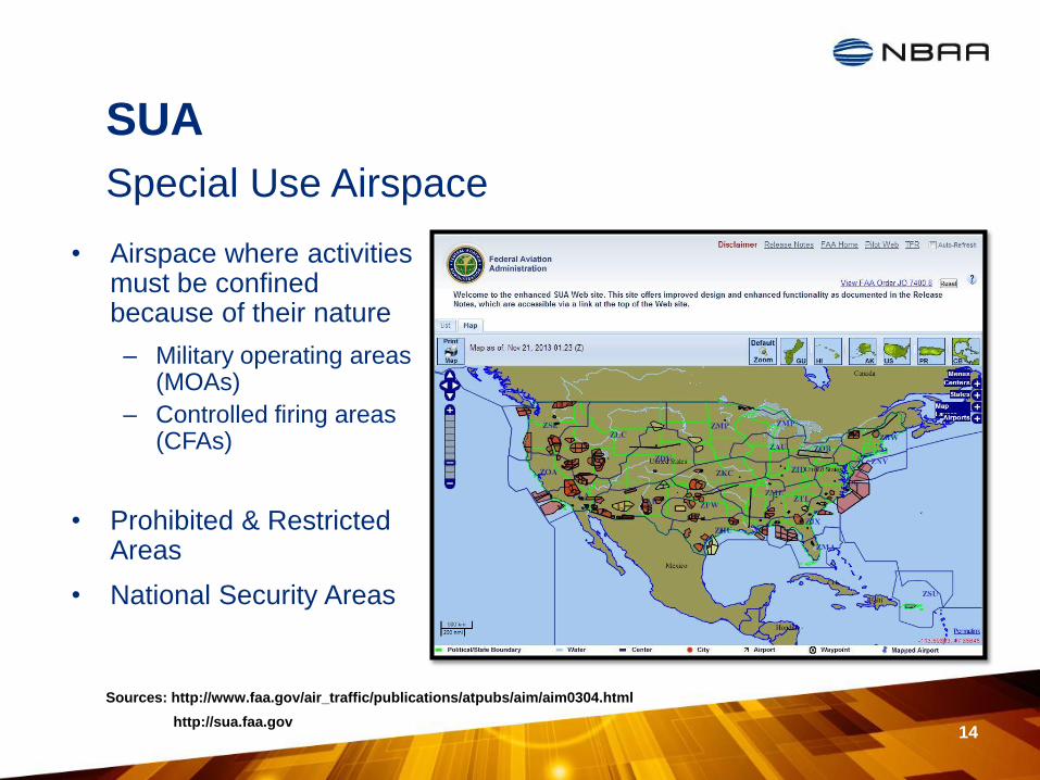
SUA
14
Special Use Airspace
Sources: http://www.faa.gov/air_traffic/publications/atpubs/aim/aim0304.html
http://sua.faa.gov
• Airspace where activities must be confined because of their nature
– Military operating areas (MOAs)
– Controlled firing areas (CFAs)
• Prohibited & Restricted Areas
• National Security Areas
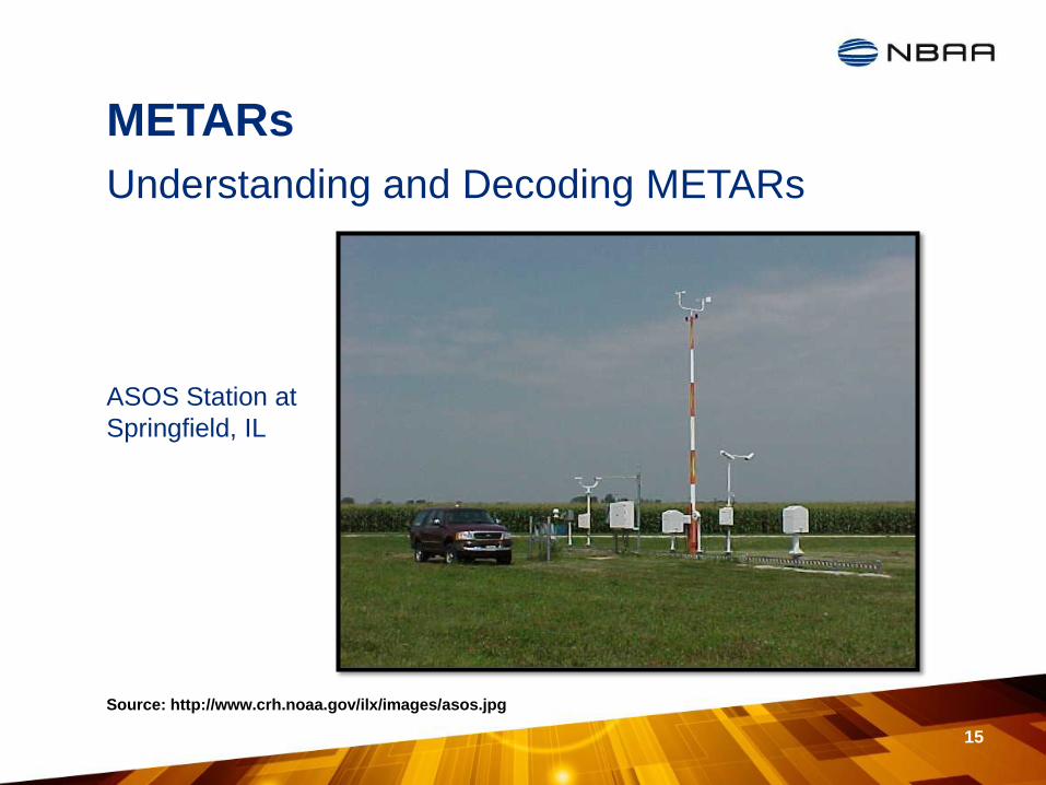
METARs
15
Understanding and Decoding METARs
Source: http://www.crh.noaa.gov/ilx/images/asos.jpg
ASOS Station at
Springfield, IL
METARs
• International Code for reporting weather conditions
• Provides pilots with trend forecasts
• Frequency is broken into two categories
– METAR
• Aviation routine weather report occurring hourly
• Synoptic reports
– METAR report issued every 6 hours (00Z, 06Z, 12Z, 18Z)
– SPECI
• Derived from the French expression for Aviation Selected Special Meteorological Report
• Non-routine (special) aviation weather report
16
Meteorological Aerodrome Report
Source: http://www2.fiu.edu/~hajian/MET3502/MET3502_Synoptic_Lec4.pdf
METARs
17
Source: http://www.met.tamu.edu/class/metar/metar-pg4.html
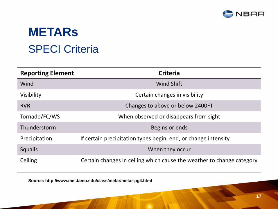
SPECI Criteria
Reporting Element Criteria
Wind Wind Shift
Visibility Certain changes in visibility
RVR Changes to above or below 2400FT
Tornado/FC/WS When observed or disappears from sight
Thunderstorm Begins or ends
Precipitation If certain precipitation types begin, end, or change intensity
Squalls When they occur
Ceiling Certain changes in ceiling which cause the weather to change category
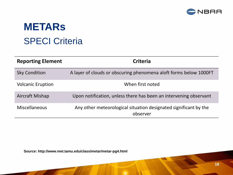
METARs
18
Source: http://www.met.tamu.edu/class/metar/metar-pg4.html
Reporting Element Criteria
Sky Condition A layer of clouds or obscuring phenomena aloft forms below 1000FT
Volcanic Eruption When first noted
Aircraft Mishap Upon notification, unless there has been an intervening observant
Miscellaneous Any other meteorological situation designated significant by the observer
SPECI Criteria
METARs
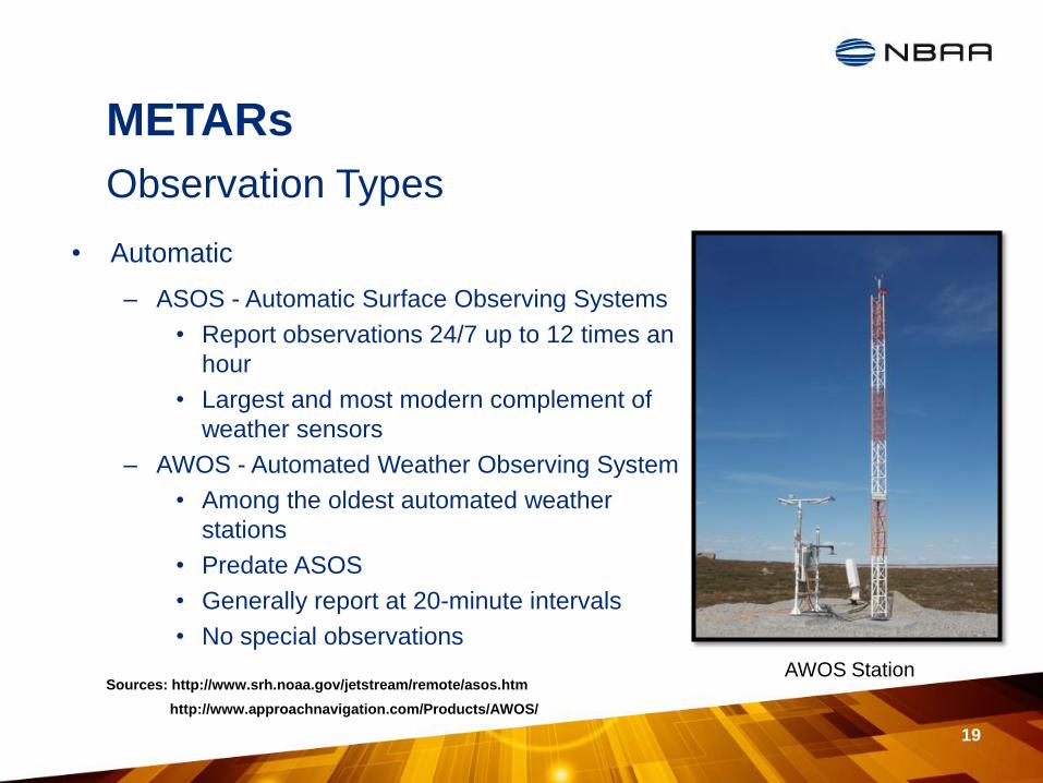
• Automatic
– ASOS - Automatic Surface Observing Systems
• Report observations 24/7 up to 12 times an
hour
• Largest and most modern complement of
weather sensors
– AWOS - Automated Weather Observing System
• Among the oldest automated weather
stations
• Predate ASOS
• Generally report at 20-minute intervals
• No special observations
19
Observation Types
Sources: http://www.srh.noaa.gov/jetstream/remote/asos.htm
http://www.approachnavigation.com/Products/AWOS/
AWOS Station
METARs
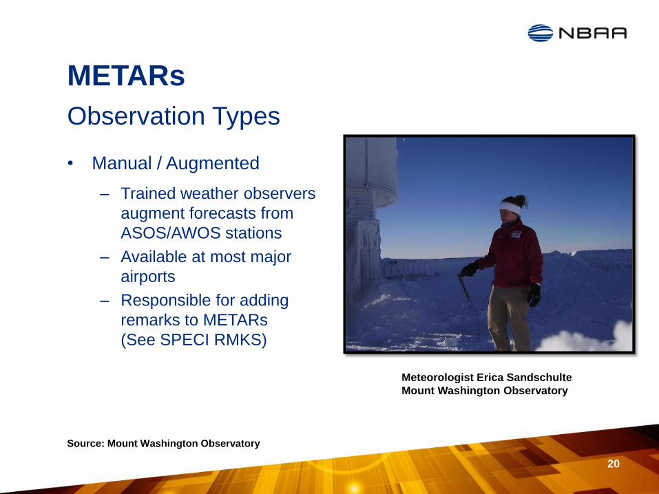
• Manual / Augmented
– Trained weather observers
augment forecasts from
ASOS/AWOS stations
– Available at most major
airports
– Responsible for adding
remarks to METARs
(See SPECI RMKS)
20
Observation Types
Source: Mount Washington Observatory
Meteorologist Erica Sandschulte
Mount Washington Observatory

METARs
• ASOS Reports the following basic weather elements:
– Sky conditions such as cloud height and cloud amount up to 12,000 feet
– Surface visibility up to at least 10 statute miles
– Basic present weather information such as the type and intensity for rain, snow, and freezing rain
– Obstructions to vision like fog, haze, and/or dust
– Sea-level pressure and altimeter settings
– Air and dew point temperatures
– Wind direction, speed and character (gusts, squalls)
– Precipitation accumulation
– Selected significant remarks including- variable cloud height, variable visibility, precipitation beginning/ending times, rapid pressure changes, pressure change tendency, wind shift, peak wind.
21
ASOS
Source: http://www.srh.noaa.gov/jetstream/remote/asos.htm
METARs
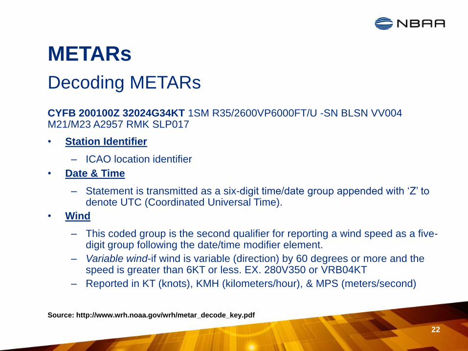
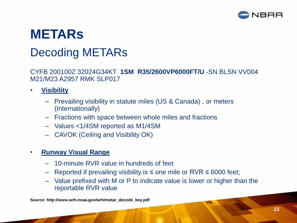
CYFB 200100Z 32024G34KT 1SM R35/2600VP6000FT/U -SN BLSN VV004 M21/M23 A2957 RMK SLP017
• Station Identifier
– ICAO location identifier
• Date & Time
– Statement is transmitted as a six-digit time/date group appended with ‘Z’ to denote UTC (Coordinated Universal Time).
• Wind
– This coded group is the second qualifier for reporting a wind speed as a five-digit group following the date/time modifier element.
– Variable wind-if wind is variable (direction) by 60 degrees or more and the speed is greater than 6KT or less. EX. 280V350 or VRB04KT
– Reported in KT (knots), KMH (kilometers/hour), & MPS (meters/second)
22
Decoding METARs
Source: http://www.wrh.noaa.gov/wrh/metar_decode_key.pdf
METARs
CYFB 200100Z 32024G34KT 1SM R35/2600VP6000FT/U -SN BLSN VV004 M21/M23 A2957 RMK SLP017
• Visibility
– Prevailing visibility in statute miles (US & Canada) , or meters (Internationally)
– Fractions with space between whole miles and fractions
– Values <1/4SM reported as M1/4SM
– CAVOK (Ceiling and Visibility OK)
• Runway Visual Range
– 10-minute RVR value in hundreds of feet
– Reported if prevailing visibility is ≤ one mile or RVR ≤ 6000 feet;
– Value prefixed with M or P to indicate value is lower or higher than the reportable RVR value
23
Decoding METARs
Source: http://www.wrh.noaa.gov/wrh/metar_decode_key.pdf
Intensity or Proximity
Descriptor
Precipitation
Obscuration
Other
- Light MI Shallow DZ Drizzle BR Mist PO Dust/Sand Whirls
BC Patches RA Rain FG FOG SQ Squalls
Mod DR Low Drift SN Snow FU Smoke FC +FC
Funnel Cloud Tornado/Spout
BL Blowing SG Snow grains DU Dust SS Sandstorm
+ Heavy SH Showers IC Ice Crystals SA Sand DS Dust storm
TS Thunderstorm PL Ice Pellets HZ Haze
VC Vicinity FZ Freezing GR Hail PY Spray
PR Partial GS Small Hail VA Volcanic Ash
METARs
24 Source: http://www.met.tamu.edu/class/metar/metar-pg9-ww.html
Decoding METARs CYFB 200100Z 32024G34KT 1SM R35/2600VP6000FT/U -SN BLSN VV004
M21/M23 A2957 RMK SLP017
METARs
CYFB 200100Z 32024G34KT 1SM R35/2600VP6000FT/U -SN BLSN VV004 M21/M23 A2957 RMK SLP017
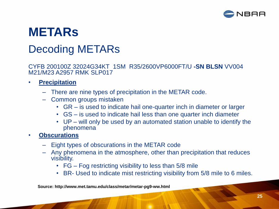
• Precipitation
– There are nine types of precipitation in the METAR code.
– Common groups mistaken
• GR – is used to indicate hail one-quarter inch in diameter or larger
• GS – is used to indicate hail less than one quarter inch diameter
• UP – will only be used by an automated station unable to identify the phenomena
• Obscurations
– Eight types of obscurations in the METAR code
– Any phenomena in the atmosphere, other than precipitation that reduces visibility.
• FG – Fog restricting visibility to less than 5/8 mile
• BR- Used to indicate mist restricting visibility from 5/8 mile to 6 miles.
25
Decoding METARs
Source: http://www.met.tamu.edu/class/metar/metar-pg9-ww.html

METARs
CYFB 200100Z 32024G34KT 1SM R35/2600VP6000FT/U -SN BLSN VV004
M21/M23 A2957 RMK SLP017
• Sky Cover
– Cloud amount and height (based on octants)
• CLR (no clouds detected below 12000 feet) 0/8
• FEW (few) 1/8 – 2/8
• SCT (scattered) 3/8 – 4/8
• BKN (broken) 5/8 – 7/8
• OVC (overcast) 8/8
• Cloud amount followed by 3-digit height in hundreds of feet
• Vertical visibility (VV) followed by height for indefinite ceiling
26
Decoding METARs
Source: http://www.met.tamu.edu/class/metar/metar-pg9-ww.html
METARs
CYFB 200100Z 32024G34KT 1SM R35/2600VP6000FT/U -SN BLSN VV004
M21/M23 A2957 RMK SLP017
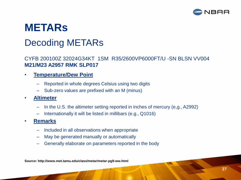
• Temperature/Dew Point
– Reported in whole degrees Celsius using two digits
– Sub-zero values are prefixed with an M (minus)
• Altimeter
– In the U.S. the altimeter setting reported in inches of mercury (e,g., A2992)
– Internationally it will be listed in millibars (e.g., Q1016)
• Remarks
– Included in all observations when appropriate
– May be generated manually or automatically
– Generally elaborate on parameters reported in the body
27
Decoding METARs
Source: http://www.met.tamu.edu/class/metar/metar-pg9-ww.html
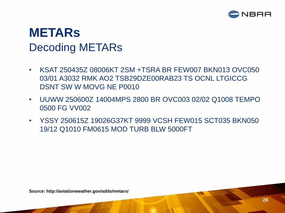
METARs
• KSAT 250435Z 08006KT 2SM +TSRA BR FEW007 BKN013 OVC050
03/01 A3032 RMK AO2 TSB29DZE00RAB23 TS OCNL LTGICCG
DSNT SW W MOVG NE P0010
• UUWW 250600Z 14004MPS 2800 BR OVC003 02/02 Q1008 TEMPO
0500 FG VV002
• YSSY 250615Z 19026G37KT 9999 VCSH FEW015 SCT035 BKN050
19/12 Q1010 FM0615 MOD TURB BLW 5000FT
28
Decoding METARs
Source: http://aviationweather.gov/adds/metars/
TAFs
29
Terminal Aerodrome Forecast
Source: https://www.meted.ucar.edu/
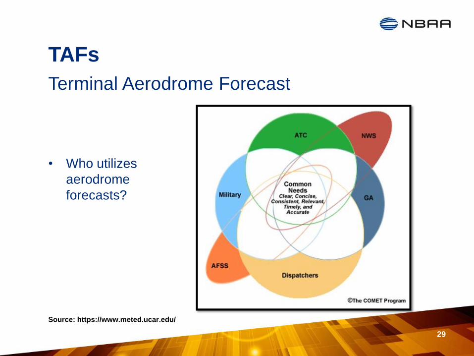
• Who utilizes
aerodrome
forecasts?
TAFs
30
Terminal Aerodrome Forecast
Source: http://www.pilotworkshop.com/tips/aviation_weather_services.htm
http://www.nws.noaa.gov/directives/sym/pd01008013curr.pdf
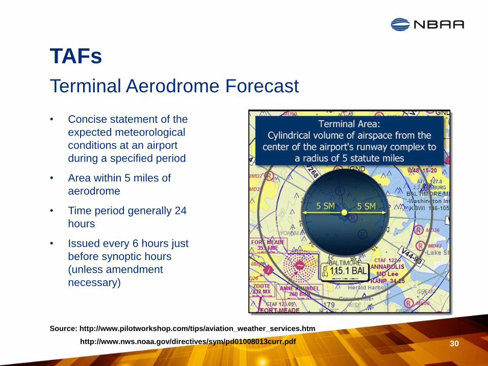
• Concise statement of the
expected meteorological
conditions at an airport
during a specified period
• Area within 5 miles of
aerodrome
• Time period generally 24
hours
• Issued every 6 hours just
before synoptic hours
(unless amendment
necessary)
TAFs
31
Terminal Aerodrome Forecast
Sources: http://www.nws.noaa.gov/directives/sym/pd01008013curr.pdf
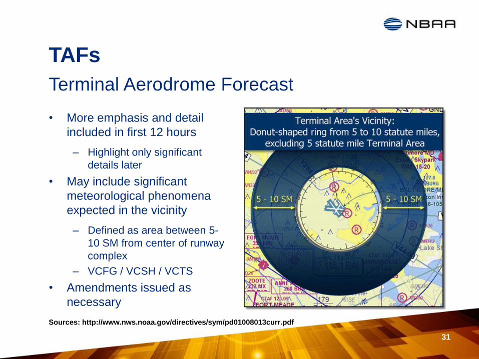
• More emphasis and detail
included in first 12 hours
– Highlight only significant
details later
• May include significant
meteorological phenomena
expected in the vicinity
– Defined as area between 5-
10 SM from center of runway
complex
– VCFG / VCSH / VCTS
• Amendments issued as
necessary
TAFs
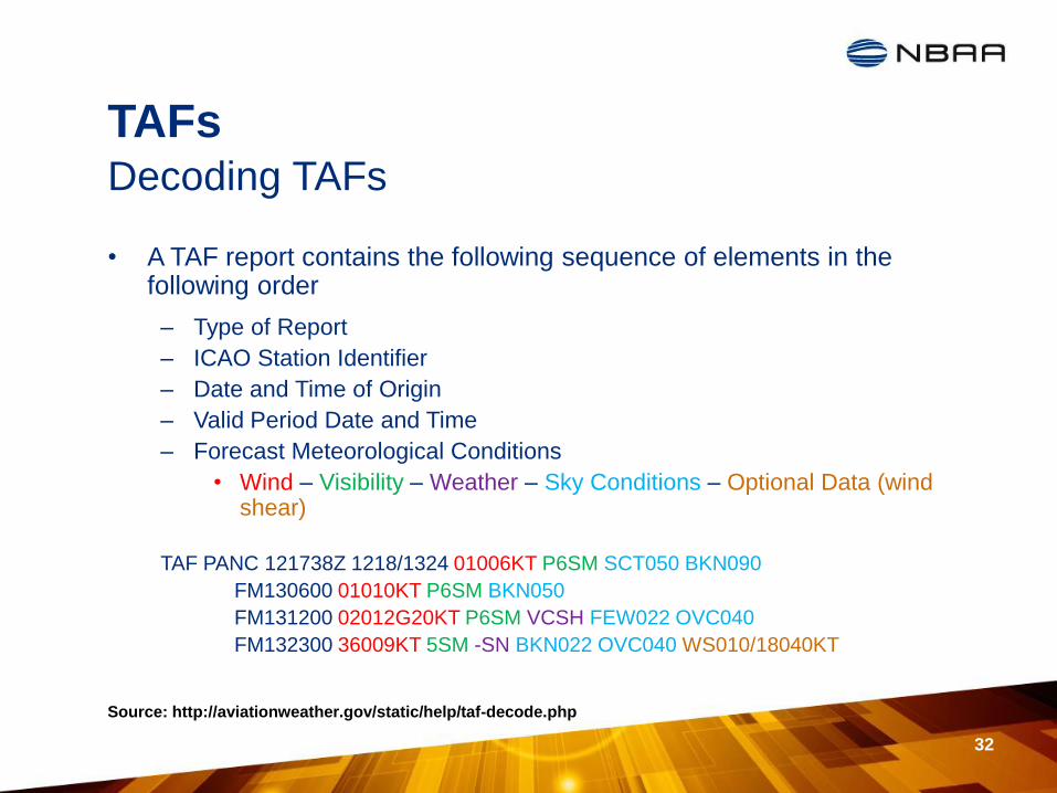
• A TAF report contains the following sequence of elements in the following order
– Type of Report
– ICAO Station Identifier
– Date and Time of Origin
– Valid Period Date and Time
– Forecast Meteorological Conditions
• Wind – Visibility – Weather – Sky Conditions – Optional Data (wind shear)
TAF PANC 121738Z 1218/1324 01006KT P6SM SCT050 BKN090
FM130600 01010KT P6SM BKN050
FM131200 02012G20KT P6SM VCSH FEW022 OVC040
FM132300 36009KT 5SM -SN BKN022 OVC040 WS010/18040KT
32
Decoding TAFs
Source: http://aviationweather.gov/static/help/taf-decode.php
TAFs
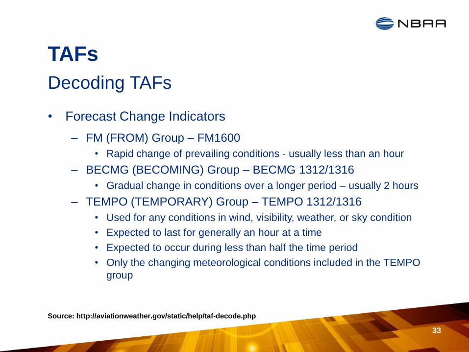
• Forecast Change Indicators
– FM (FROM) Group – FM1600
• Rapid change of prevailing conditions - usually less than an hour
– BECMG (BECOMING) Group – BECMG 1312/1316
• Gradual change in conditions over a longer period – usually 2 hours
– TEMPO (TEMPORARY) Group – TEMPO 1312/1316
• Used for any conditions in wind, visibility, weather, or sky condition
• Expected to last for generally an hour at a time
• Expected to occur during less than half the time period
• Only the changing meteorological conditions included in the TEMPO
group
33
Decoding TAFs
Source: http://aviationweather.gov/static/help/taf-decode.php
TAFs
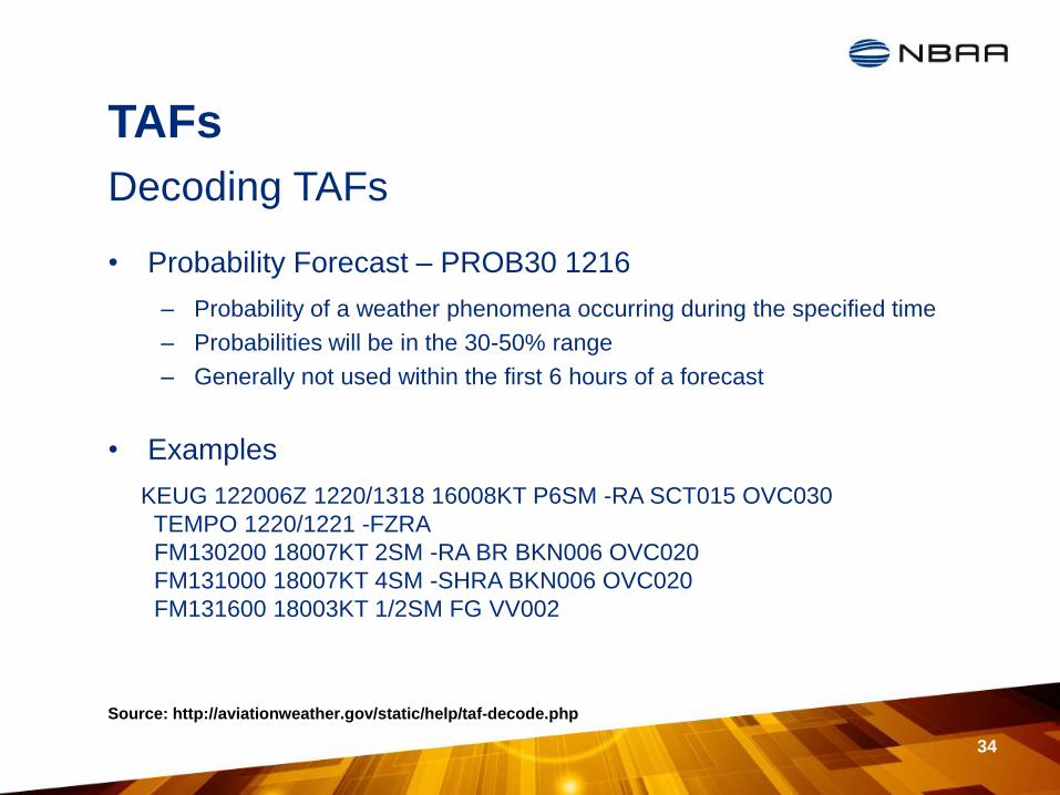
• Probability Forecast – PROB30 1216
– Probability of a weather phenomena occurring during the specified time
– Probabilities will be in the 30-50% range
– Generally not used within the first 6 hours of a forecast
• Examples
KEUG 122006Z 1220/1318 16008KT P6SM -RA SCT015 OVC030
TEMPO 1220/1221 -FZRA
FM130200 18007KT 2SM -RA BR BKN006 OVC020
FM131000 18007KT 4SM -SHRA BKN006 OVC020
FM131600 18003KT 1/2SM FG VV002
34
Decoding TAFs
Source: http://aviationweather.gov/static/help/taf-decode.php
TAFs
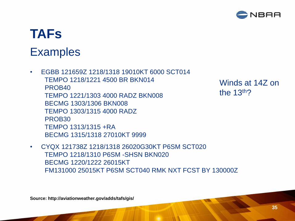
• EGBB 121659Z 1218/1318 19010KT 6000 SCT014
TEMPO 1218/1221 4500 BR BKN014
PROB40
TEMPO 1221/1303 4000 RADZ BKN008
BECMG 1303/1306 BKN008
TEMPO 1303/1315 4000 RADZ
PROB30
TEMPO 1313/1315 +RA
BECMG 1315/1318 27010KT 9999
• CYQX 121738Z 1218/1318 26020G30KT P6SM SCT020
TEMPO 1218/1310 P6SM -SHSN BKN020
BECMG 1220/1222 26015KT
FM131000 25015KT P6SM SCT040 RMK NXT FCST BY 130000Z
35
Examples
Source: http://aviationweather.gov/adds/tafs/gis/
Winds at 14Z on
the 13th?

Application -- Overview
• Let’s take the knowledge & create a skill set
– Analysis
• Long range(5-3 days)
• Shorter range(48-24 hours)
• Day of flight(24-0 hours)
– Communication of impact
– Resources
• Charts
• Radar
• Websites
• Products
36
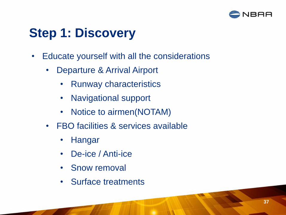
Step 1: Discovery
37
• Educate yourself with all the considerations
• Departure & Arrival Airport
• Runway characteristics
• Navigational support
• Notice to airmen(NOTAM)
• FBO facilities & services available
• Hangar
• De-ice / Anti-ice
• Snow removal
• Surface treatments
Step 1: Discovery
• Departure & Arrival Airport
– Runway characteristics
• Length & Width
• Airport elevation
• Weight capacity
– Navigational support
• ILS, LOC, GPS more common
• Approach minimums
– Notice to Airmen(NOTAMs)
• Check throughout analysis
• Show stoppers
38
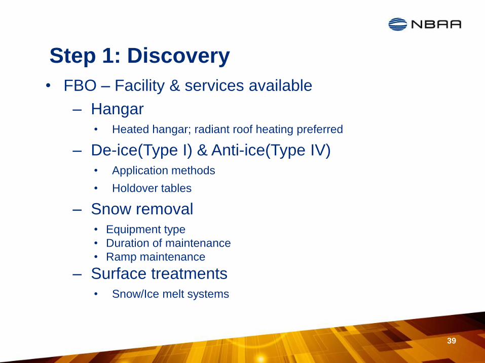
Step 1: Discovery
• FBO – Facility & services available
– Hangar • Heated hangar; radiant roof heating preferred
– De-ice(Type I) & Anti-ice(Type IV) • Application methods
• Holdover tables
– Snow removal • Equipment type
• Duration of maintenance
• Ramp maintenance
– Surface treatments • Snow/Ice melt systems
39
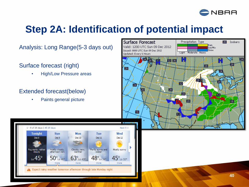
Step 2A: Identification of potential impact
40
Analysis: Long Range(5-3 days out)
Surface forecast (right)
• High/Low Pressure areas
Extended forecast(below)
• Paints general picture
Step 2B: Identification of potential impact
41
• Analysis: Shorter Range(48-24 hours out)
• Forecast is becoming more accurate
• Continue to utilize surface forecast & extended forecast
• Compare forecasts from long range analysis to predict pattern
• If there is delay potential action maybe necessary
• Include crewmembers to discuss potential impact
• Prepare statement of advisement to passenger for awareness if warranted
• Some contingency planning might be necessary
Step 2C: Identification of potential impact
42
• Analysis: Day of flight(24-0 hours out)
• Text weather
• Aviation Routine Weather
Reports(METAR)
• Aerodrome forecasts(TAF)
• National Airspace System(NAS)
• Radar / SIGMETS
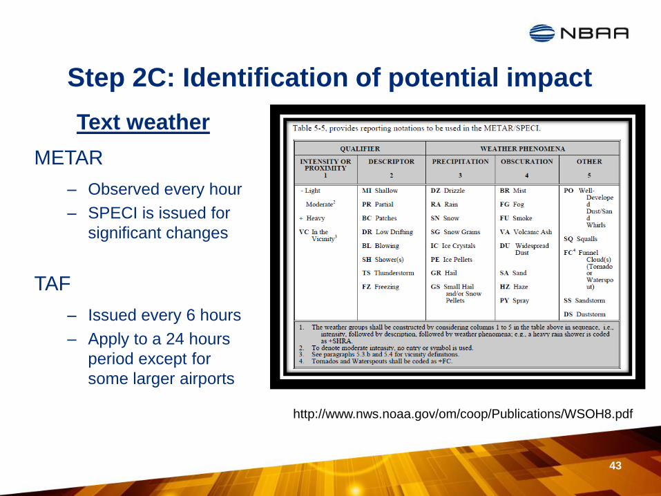
Step 2C: Identification of potential impact
Text weather
METAR
– Observed every hour
– SPECI is issued for
significant changes
TAF
– Issued every 6 hours
– Apply to a 24 hours
period except for
some larger airports
43
http://www.nws.noaa.gov/om/coop/Publications/WSOH8.pdf
METAR / TAF – Next Steps
• Once decoded you will utilize the information for:
– Determining Primary RWY selection
– Assessing margin for potential delay
• Primary RWY selection
– Refer to previous discovery step
– Wind direction / speed determines selection
– Each RWY has minimums defined within chart
• Comparing minimums to decoded text weather = MARGIN
• Let the margin help you make the decision
– Fair amount of margin = Some consideration for back up plan
– Very little margin = Put back up plan in place
– No margin = Move to back up plan
Part A = Decode; Part B = Determine Margin for Delay
44

NOTAM – Next Steps
• Once decoded you will need to compare to:
– Trip schedule
– Weather schedule
• Looking for show stoppers during the trip arrival / departure
– RWY Closures
– Braking Action reports
– Navigation equipment information
– TFR information
– Airport construction information
– Special event information
Part A = Decode & Part B = Compare
45
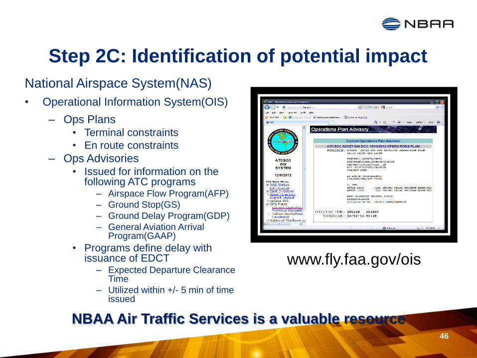
Step 2C: Identification of potential impact
National Airspace System(NAS)
• Operational Information System(OIS)
– Ops Plans • Terminal constraints
• En route constraints
– Ops Advisories • Issued for information on the
following ATC programs – Airspace Flow Program(AFP)
– Ground Stop(GS)
– Ground Delay Program(GDP)
– General Aviation Arrival Program(GAAP)
• Programs define delay with issuance of EDCT
– Expected Departure Clearance Time
– Utilized within +/- 5 min of time issued
46
www.fly.faa.gov/ois
NBAA Air Traffic Services is a valuable resource

Step 2C: Identification of potential impact
Composite Radar
– Precipitation finder
– Return levels • Level 1 – Green/Light
• Level 2 – Yellow/Moderate
• Level 3 – Red/Severe
Sigmets
– NWS product graphic & text
– Convective • Issued every hour
• Valid for two hours
– Non-convective • Relates to severe turbulence
47
Step 3: Communication of impact
• Goal #1: Create situational awareness
• Goal #2: Avoid panic
– Suggestions to satisfy goal #1 & goal #2
• promise continuous monitoring and further
advisements
• avoid aviation technical terminology
• maintain solid relationship during entire scheduling
process to establish trust
48
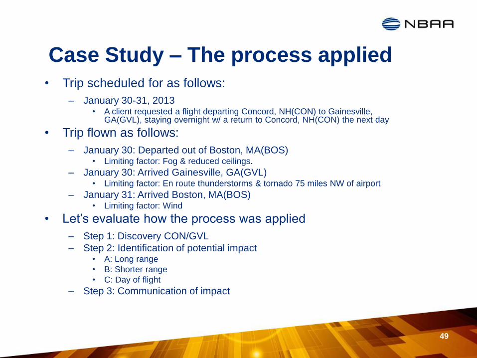
Case Study – The process applied
• Trip scheduled for as follows:
– January 30-31, 2013 • A client requested a flight departing Concord, NH(CON) to Gainesville,
GA(GVL), staying overnight w/ a return to Concord, NH(CON) the next day
• Trip flown as follows:
– January 30: Departed out of Boston, MA(BOS) • Limiting factor: Fog & reduced ceilings.
– January 30: Arrived Gainesville, GA(GVL) • Limiting factor: En route thunderstorms & tornado 75 miles NW of airport
– January 31: Arrived Boston, MA(BOS) • Limiting factor: Wind
• Let’s evaluate how the process was applied
– Step 1: Discovery CON/GVL
– Step 2: Identification of potential impact • A: Long range
• B: Shorter range
• C: Day of flight
– Step 3: Communication of impact
49
Resources – Websites Flight Delay Information
http://www.fly.faa.gov/flyfaa/usmap.jsp
NAS Status - Operational Information System(OIS) http://www.fly.faa.gov/ois/
EDCT Look up
http://www.fly.faa.gov/edct/jsp/edctLookUp.jsp
Aviation Weather
http://www.aviationweather.gov/
http://www.accuweather.com/
http://www.weather.com
http://www.wunderground.com
GFS Forecast
http://charlie.wxcaster.com/text/GFSSFC/GFS_KBFI.txt
Localized Aviation MOS Product(LAMP)
http://www.nws.noaa.gov/mdl/gfslamp/statebull.shtml
50

Resources – More websites
Seasonal – Convective Forecast http://aviationweather.gov/products/ccfp/
Historical query http://www.ogimet.com/metars.phtml.en
Seasonal - Tropical
http://www.nhc.noaa.gov/
51
Reference Material
• Most Common NOTAM Contractions
– http://www.nbaa.org/ops/airspace/issues/notam-
realignment/200710_NOTAM_Brochure.pdf
• Understanding TFRs
– http://www.faa.gov/pilots/safety/notams_tfr/media/tfrweb.pdf
• METAR/TAF Acronyms
– http://www.wrh.noaa.gov/wrh/metar_decode_key.pdf
• NWS Directive on TAFs
– http://www.nws.noaa.gov/directives/sym/pd01008013curr.pdf
52