Using Satellites to Predict Earthquakes, Volcano Eruptions ... · Enabling improved predictive...
20
1 Using Satellites to Predict Earthquakes, Volcano Eruptions, Identify and Track Tsunamis Len Losik, PhD. 1 Failure Analysis, Capitola CA. Abstract Space offers the civil science and military science communities the location to measure the earth’s gravity gradient to understand the Earth’s underground behavior including the movement of magma from the Earth’s core to the surface that is that is responsible for tectonic movement that leads to surprise catastrophic earthquakes, tsunamis and volcano eruptions. The same information will identify locations of voids in the earth that may hold weapons of mass destruction in hostile nations that are inaccessible. Using a global, real-time satellite-based underground mapping system offers the Earth science community the information necessary to understand and quantify the Earth and its internal behavior, on the Earth’s surface and in the Earth’s atmosphere. A real-time, global satellite-based underground mapping constellation will measure the earth’s gravity in real-time and measurements from many satellites simultaneously will provide the data to model the earth’s dynamic underground movement that drives the changes in the Earth’s surface in 3-D. A 3- D real-time model of the Earth will have the sensitivity to identify the behavior that scientists can use to predict tectonic plate motion that leads to earthquakes and volcano eruptions that will stop massive death and enormous destruction such as occurred in a variety of locations around the Earth. It will also be the platform for broadcasting globally the warning of an upcoming earthquake or volcano eruption in weeks and months rather than seconds and minutes that is achieved today. 1. INTRODUCTION The Earth is a complex, dynamic system we do not yet understand enough to ensure the safety of its population. The Earth system, like the human body, comprises diverse components that interact in complex ways. To ensure man’s safety and well-being, we need to understand the Earth's underground behavior, atmosphere, lithosphere, hydrosphere, cryosphere and biosphere as a connected system and not as individual components. Our planet is changing on all spatial and temporal scales. The Earth science community develops a scientific understanding of Earth's complex system and their response to natural and human-induced changes. To accomplish this we need to be able to predict climate, weather and natural hazards such as earthquakes, volcano eruptions and tsunamis that have been responsible for incredible death and destruction. A major component of Earth science is a coordinated series of underground, satellite and airborne missions for long-term global observations of the underground, land surface, biosphere, atmosphere and oceans. This coordinated approach enables understanding of the Earth as an integrated system. The Earth science community is completing the development and launch of a set of foundational missions, new survey missions and climate missions that will completed over many decades rather than just a few years. [10] The Earth science community looks to space as the most strategic location to observe and generate the information to quantify the changes to the Earth from natural and man-made influences and its many components. This will be done by using the new foundational space missions that are in development and include such programs _________________________ 1 President and Chief Technical Officer, 501 Plum Street, Suite 48, Capitola CA, Senior Member
Transcript of Using Satellites to Predict Earthquakes, Volcano Eruptions ... · Enabling improved predictive...
1
Using Satellites to Predict Earthquakes, Volcano Eruptions,
Identify and Track Tsunamis
Len Losik, PhD.1
Failure Analysis, Capitola CA.
Abstract
Space offers the civil science and military science communities the location to measure
the earth’s gravity gradient to understand the Earth’s underground behavior including the
movement of magma from the Earth’s core to the surface that is that is responsible for
tectonic movement that leads to surprise catastrophic earthquakes, tsunamis and volcano
eruptions. The same information will identify locations of voids in the earth that may hold
weapons of mass destruction in hostile nations that are inaccessible. Using a global, real-time
satellite-based underground mapping system offers the Earth science community the
information necessary to understand and quantify the Earth and its internal behavior, on
the Earth’s surface and in the Earth’s atmosphere. A real-time, global satellite-based
underground mapping constellation will measure the earth’s gravity in real-time and
measurements from many satellites simultaneously will provide the data to model the earth’s
dynamic underground movement that drives the changes in the Earth’s surface in 3-D. A 3-
D real-time model of the Earth will have the sensitivity to identify the behavior that scientists
can use to predict tectonic plate motion that leads to earthquakes and volcano eruptions that
will stop massive death and enormous destruction such as occurred in a variety of locations
around the Earth. It will also be the platform for broadcasting globally the warning of an
upcoming earthquake or volcano eruption in weeks and months rather than seconds and
minutes that is achieved today.
1. INTRODUCTION
The Earth is a complex, dynamic system we do not yet understand enough to ensure the safety of its population.
The Earth system, like the human body, comprises diverse components that interact in complex ways. To ensure
man’s safety and well-being, we need to understand the Earth's underground behavior, atmosphere, lithosphere,
hydrosphere, cryosphere and biosphere as a connected system and not as individual components. Our planet is
changing on all spatial and temporal scales.
The Earth science community develops a scientific understanding of Earth's complex system and their response
to natural and human-induced changes. To accomplish this we need to be able to predict climate, weather and
natural hazards such as earthquakes, volcano eruptions and tsunamis that have been responsible for incredible death
and destruction.
A major component of Earth science is a coordinated series of underground, satellite and airborne missions for
long-term global observations of the underground, land surface, biosphere, atmosphere and oceans. This coordinated
approach enables understanding of the Earth as an integrated system. The Earth science community is completing
the development and launch of a set of foundational missions, new survey missions and climate missions that will
completed over many decades rather than just a few years. [10]
The Earth science community looks to space as the most strategic location to observe and generate the
information to quantify the changes to the Earth from natural and man-made influences and its many components.
This will be done by using the new foundational space missions that are in development and include such programs
_________________________ 1President and Chief Technical Officer, 501 Plum Street, Suite 48, Capitola CA, Senior Member

2
as: Aquarius, National Polar Orbiting Environmental Space Science Preparatory Project (NPP), Landsat Data
Continuity Mission (LDCM), and Global Precipitation Measurement (GPM). [10]
The Decadal Survey missions are
those guided by the decadal survey produced by the National Research Council of the National Academy of
Sciences and published in 2007. These missions include Soil Moisture Active-Passive (SMAP), Ice, Cloud and land
Elevation Satellite (ICESat-II), Hyper spectral Infrared Imager (HyspIRI), Active Sensing of CO2 Emissions Over
Nights, Days, and Seasons (ASCENDS), Surface Water and Topography (SWOT), Geostationary Coastal and Air
Pollution Events (GEO-CAPE), and Aerosol-Clouds-Ecosystems (ACE). Earth Venture, also a recommendation of
the decadal survey, consists of low cost, competed suborbital and orbital missions as well as instruments for
Missions of Opportunity. [10]
The Climate Continuity missions include Orbiting Carbon Observatory-2 (OCO-2), Stratospheric Aerosol
and Gas Experiment – III (SAGE III), Gravity Recovery and Climate Experiment Follow-on (GRACE-FO), and Pre-
Aerosol, Clouds, and Ocean Ecosystem (PACE).
Over the coming decades, the Earth science community and research partners will pioneer the use of space-
borne, aircraft and underground mapping missions to characterize, understand, and predict variability and trends in
Earth's system from deep underground to the tops of the earth’s fragile atmosphere for both research and
applications.
Figure 1 includes information from the Earth science program that was established to use the advanced
technology to understand and protect our home planet by using our view from space to study the Earth system and
improve and predict the impact to the of Earth system from changes.
Figure 1. An Example of the Geodetic Information from Space Generated by the Earth Science Community
to Understand the Earth’s Different Components
Earth is the only planet we know to be capable of sustaining biological life. It is our lifeboat in the vast expanse
of space. Over the past 50 years, world population has doubled, grain yields have tripled and economic output has
grown sevenfold. Earth science research can ascertain whether and how the Earth can sustain this growth in the
future. Economically, $3 trillion annually of the U.S. economy is influenced by Earth’s climate, weather and natural
hazards, providing economic incentive to study all of the Earth.
Earth science includes such actions as conducting and sponsoring research, collects new observations, develops
technologies and extends science and technology education to learners of all ages. Earth science community works
closely with our global partners in government, industry, and the public to enhance economic security, and
environmental stewardship, benefiting society in many tangible ways.
Earth science community conducts and sponsors research to answer fundamental questions about the changes
we see in climate, weather, tectonic motion and other natural hazards, and deliver sound science that helps decision-
makers make the informed decisions. Earth science inspires the next generation of explorers by providing

3
opportunities for learners of all ages to investigate the Earth system using unique ground, atmospheric and space-
based resources, and the Earth science research is strengthening science, technology, engineering and mathematics
education nationwide.
The Earth systematic missions include a broad range of multi-disciplinary science investigations aimed at
developing a scientific understanding of the Earth system from deep underground to the top of the atmosphere and
its response to natural and human-induced forces.
Understanding these forces will help in determining how to mitigate them, appropriately and where possible, to
avoid climate changes. The regional consequences of these forces--e.g., changes in precipitation patterns, length of
growing seasons, severity of storms, change of sea level--must be understood to determine which aspects of climate
change are most harmful and how to adapt to those changes that cannot be mitigated. Some anticipated outcomes in
the future include:
Understanding and improving predictive capability for changes in the Earth’s tectonic plate movement,
earthquakes, tsunamis, ozone layer, climate and air quality associated with changes in atmospheric
compositions associated with volcano eruptions and man-made influences.
Enabling improved predictive capability for earthquakes, volcano eruptions, tsunamis, weather and extreme
weather events such as hurricanes and tornados.
Quantifying global land coverage change and terrestrial and marine productivity, and in improving carbon
cycle and ecosystem models as the Earth changes from underground movement.
Quantifying the key reservoirs and fluxes in the global water cycle and improving models of water cycle
change and fresh water availability.
Understanding the role of earthquakes, volcano eruptions, tectonic motion, ocean currents, atmosphere and
ice in the climate system and in improving predictive capability for future evolution.
Characterizing and understanding underground Earth motion, Earth surface changes and variability of the
Earth’s gravitational and magnetic fields related to underground movement and natural changes.
Expanding and accelerating the realization of societal benefits from the Earth science community.
The Earth science community conducts explorations that are enabled by access to space and leverages
humankind’s vantage point into space with observatories underground, on aircraft and in Earth orbit and deep space,
spacecraft visiting the Moon and other planetary bodies, and robotic landers, rovers, and sample return missions.
From space, in space, and about space, Earth science communities vision encompasses questions as practical as
magma formation, tectonic movement, earthquake prediction, hurricane formation, as enticing as the prospect of
lunar resources, and as profound as the origin of the Universe. To ensure the success of the space programs through
generations to come, we must have and maintain simple and all encompassing, but compelling, long-term goals and
a coherent, thoughtful plans to achieve them.
II. Expanding The Use Of Space To Include Underground Mapping
To aid in protecting the earth’s population in danger from hostile nations, a few have resorted to using large
underground facilities to store their weapons for many decades. The U.S. has some existing resources available to
identify likely locations of underground facilities but without access to the area by highflying aircraft or ground
penetrating missiles, their real locations can only be guessed. Just as the military leverages space for many services
that are critical to the national defense including secure and safe communications, navigation, reconnaissance,
weather, ELINT, SIGENT and COMINT, space can also be leveraged to identify potential locations of underground
facilities deep in hostile nations that are a threat to the national defense. Space offers the Earth science community
accessibility for services that are not available from any other location.
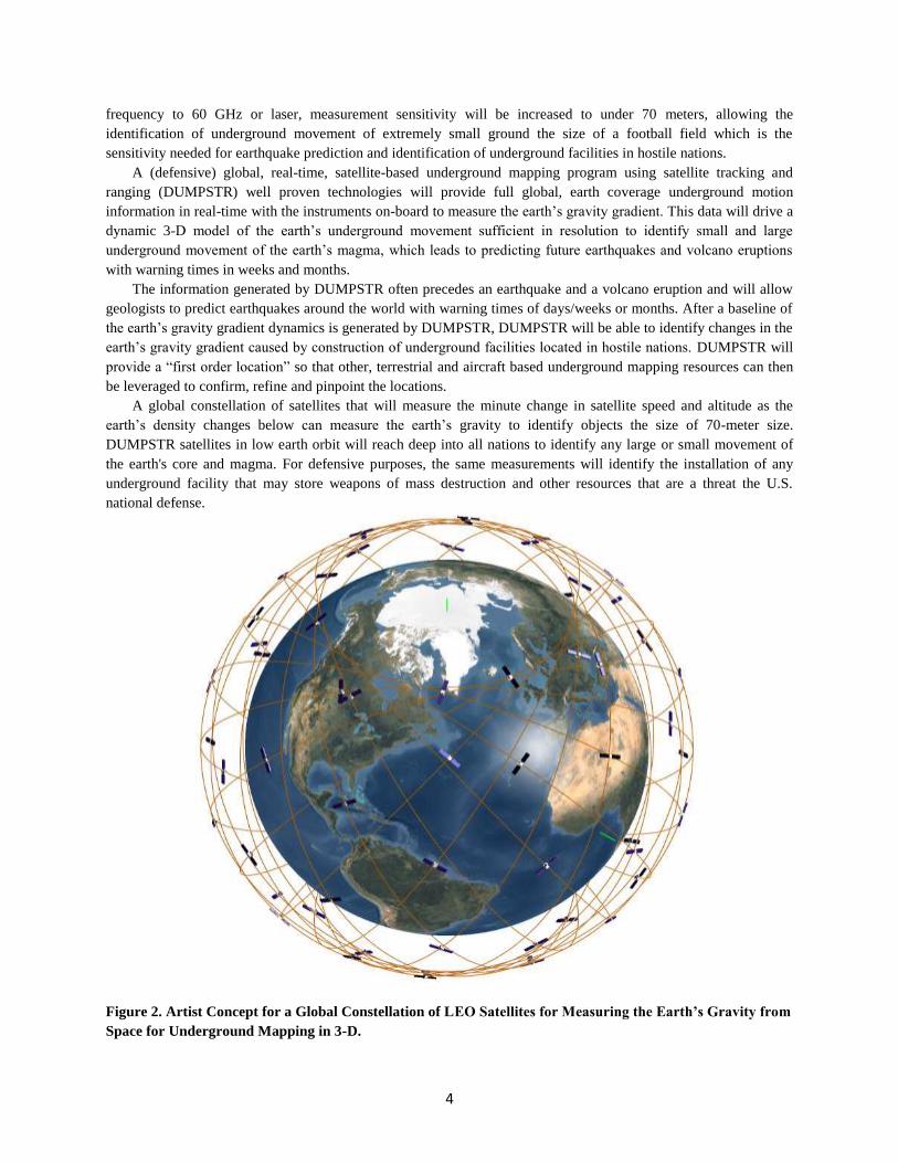
The current U.S. satellite-based underground mapping systems provide measurement sensitivity to 700 meters
using a 2-satellite system and a Ka-Band RF crosslink system. The performance of the crosslink system to measure
changes in satellite velocity is dictated by the frequency of the Ka-band RF link. By increasing the crosslink
4
frequency to 60 GHz or laser, measurement sensitivity will be increased to under 70 meters, allowing the
identification of underground movement of extremely small ground the size of a football field which is the
sensitivity needed for earthquake prediction and identification of underground facilities in hostile nations.
A (defensive) global, real-time, satellite-based underground mapping program using satellite tracking and
ranging (DUMPSTR) well proven technologies will provide full global, earth coverage underground motion
information in real-time with the instruments on-board to measure the earth’s gravity gradient. This data will drive a
dynamic 3-D model of the earth’s underground movement sufficient in resolution to identify small and large
underground movement of the earth’s magma, which leads to predicting future earthquakes and volcano eruptions
with warning times in weeks and months.
The information generated by DUMPSTR often precedes an earthquake and a volcano eruption and will allow
geologists to predict earthquakes around the world with warning times of days/weeks or months. After a baseline of
the earth’s gravity gradient dynamics is generated by DUMPSTR, DUMPSTR will be able to identify changes in the
earth’s gravity gradient caused by construction of underground facilities located in hostile nations. DUMPSTR will
provide a “first order location” so that other, terrestrial and aircraft based underground mapping resources can then
be leveraged to confirm, refine and pinpoint the locations.
A global constellation of satellites that will measure the minute change in satellite speed and altitude as the
earth’s density changes below can measure the earth’s gravity to identify objects the size of 70-meter size.
DUMPSTR satellites in low earth orbit will reach deep into all nations to identify any large or small movement of
the earth's core and magma. For defensive purposes, the same measurements will identify the installation of any
underground facility that may store weapons of mass destruction and other resources that are a threat the U.S.
national defense.
Figure 2. Artist Concept for a Global Constellation of LEO Satellites for Measuring the Earth’s Gravity from
Space for Underground Mapping in 3-D.

5
[1] Existing instruments on satellite-based underground mapping systems used to measure the earth’s gravity
gradient are constrained due to budgetary and schedule restrictions in their performance. Several methods were
developed that will increase gravity measuring instrument sensitivity and accuracy we may exploit to identify
underground facilities in hostile nations. In addition to increased instrument sensitivity, the operational satellite
constellation's orbit altitude and satellite mass can be chosen to provide higher instrument performance.
Before design solutions can be identified for DUMPSTR, the performance parameters from the analysis need to
be quantified. The proposed parametric analysis will provide the information so that a long-term plan can be
developed that will provide the technology and/or tools to provide the accuracy needed in the event it does not
already exist.
Space-based measurements of the earth’s gravity gradient already occur for scientific purposes using the NASA
GRACE and European Space Agency (ESA) GOCE satellites. These missions exploit the Earth’s gravity gradient
for mapping movement underground. The exploitation of the Earth’s gravity gradient for national defense and
civilian safety requires gravity gradient measurements that provide higher resolution and the results from our
parametric analysis will identify the needed gravity gradient instrument performance, optimal satellite mass and
satellite orbit altitude for a variety of voids in the earth.
Once this information is identified, industry and academia can get started in research to provide what is needed.
Without a space-based underground mapping program in place and regular solicitations released for the technology
that will provide the needed performance, many academic institutions and organizations will not be aware of the
need for the research and development.
Figure 3. Artist’s Concept for a 100 Satellite Matrix used for 3-D Underground Mapping
DUMPSTR will also offer important civil applications, because the same measurement of the earth’s gravity
gradient used to identify large underground facilities will also allow the identification of the underground movement
that may precede an earthquake allowing earthquake prediction, as well as identify and track tsunamis.
The recent catastrophic earthquakes around the country of Japan demonstrate the need for worldwide
earthquake prediction and tsunami identification and tracking system. A satellite-based underground mapping
system will all provide the scientific data for geologists to identify if any precursors that may precede some
earthquakes. The precursors can be used to predict an upcoming earthquake to provide significant time for a warning
so that facilities in the general area can be secured. After the recent earthquakes around Japan, land in the region has
moved eastward by as much as 13 feet and continues to move closer after each new earthquake occurs.

6
The earth’s spin rate may also change before, during and after an earthquake. The earth’s spin axis changes
because of the unbalanced movement of the earth underground caused the earthquakes to rearrange the Earth's mass,
bringing some mass, closer to the Earth's rotation axis, causing the Earth to rotate slightly faster and causing the
length of the day to shorten.
The recent earthquakes around Japan shortened the Earth's rotation by about two millionths of a second (2 x 10⁻⁶
second). For comparison, the GPS system calculates time down to 1 x 10⁻⁹
second so that the earth’s spin rate can be
measured easily in real-time using a variety of methods. Changes to the real-time measurements of the Earth's spin
rate and calculations for the earth’s axis of rotation will provide a warning that underground movement has occurred
and that a large earthquake may occur.
The Earth still tilts on its axis by 23.5 degrees, but the Earth is spinning faster today than before the 2011
earthquakes around Japan, and our day is ever so slightly shorter. A spinning figure skater can change rotational
speed by moving their arms closer to their body to spin faster. The Earth spin rate is changed in a similar way. If a
mass of the Earth underground moves closer to its rotation axis, the planet will spin faster. Measuring the earth’s g-
field, E-field, spin rate and spin axis from space in real-time will provide the information to generate a real-time 3-D
animation of the earth.
The real-time animation of the earth’s g-field, E-field, spin rate and spin axis will allow geologists to identify
minute changes in the earth’s gravity gradient that precedes some earthquakes allowing time for facilities such as
nuclear power plants and high speed trains to stop operating safely before an earthquake occurs.
Figure 4 Variation of Orbital Period and Velocity with Distance from the Center of the Earth (a.k.a. Altitude)
Satellites have been leveraged by the U.S. military to provide many critical services that are essential to the
nation’s defense including overhead imagery (reconnaissance), electronic signal monitoring, secure and survivable
7
communications, navigation (GPS), nuclear test ban monitoring, missile warning and nuclear blast detonation and
identification. Today’s space-based military resources are designed to survive and function during and after a
catastrophic nuclear war.
The tsunamis from earthquakes often have a wave height of just a few feet but a wavelength of hundreds of
miles making space the best place to identify the presence of a tsunami and track its movement. Some of the land
around Japan has moved east by as much as 14 feet, most likely from pressure below the surface. This pressure may
be from underground movement that precedes an earthquake and it is this underground motion that DUMPSTR will
detect from space.
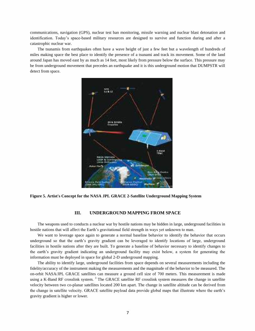
Figure 5. Artist's Concept for the NASA JPL GRACE 2-Satellite Underground Mapping System
III. UNDERGROUND MAPPING FROM SPACE
The weapons used to conducts a nuclear war by hostile nations may be hidden in large, underground facilities in
hostile nations that will affect the Earth’s gravitational field strength in ways yet unknown to man.
We want to leverage space again to generate a normal baseline behavior to identify the behavior that occurs
underground so that the earth’s gravity gradient can be leveraged to identify locations of large, underground
facilities in hostile nations after they are built. To generate a baseline of behavior necessary to identify changes to
the earth’s gravity gradient indicating an underground facility may exist below, a system for generating the
information must be deployed in space for global 2-D underground mapping.
The ability to identify large, underground facilities from space depends on several measurements including the
fidelity/accuracy of the instrument making the measurements and the magnitude of the behavior to be measured. The
on-orbit NASA/JPL GRACE satellites can measure a ground cell size of 700 meters. This measurement is made
using a K-Band RF crosslink system. 3 The GRACE satellite RF crosslink system measures the change in satellite
velocity between two co-planar satellites located 200 km apart. The change in satellite altitude can be derived from
the change in satellite velocity. GRACE satellite payload data provide global maps that illustrate where the earth’s
gravity gradient is higher or lower.

8
Figure 6. Exploded View of the NASA GRACE Underground Mapping Satellite
FALSE ALARMS
The information provided by DUMPSTR provides potential locations of underground facilities and will not be
conclusive that an underground facility exists in a hostile nation. It is expected that the information from DUMPSTR
satellites will be used to identify a likely location of an underground facility that is located in a hostile nation in
which other underground mapping assets cannot be deployed. Existing underground mapping assets that measure a
variety of signals may be leveraged to increase the certainty when a potential location is first identified by
DUMPSTR.
There are no military space assets that identify potential locations of underground facilities using the earth's
gravity. The information from DUMPSTR would identify locations that are currently not being investigated.
DUMPSTR will identify potential locations of underground facilities in hostile nations that may be suspected to
exist or when there is no indication that one exists and at locations that there is no other reason to suspect an
underground facility exist at a location.
IV. DUMPSTR Underground Mapping Payload Performance
The DUMPSTR altitude and velocity-measuring payload will be similar to the GRACE/GRAIL payload except that
the crosslink frequency will be increased to 60 GHz. This will allow an increase in gravity gradient measurement
accuracy of 50% over GRACE Ka band cross-link system. In the event that 60 GHz does not increase the accuracy
enough to increase the resolution, higher RF frequencies such as 90 GHZ can be used. In addition, a Laser crosslink
is also feasible to increase the measurement accuracy. Laser cross links were developed and demonstrated on the Air
Force TSAT geostationary communications satellite system 5 years ago before the program was cancelled.

9
V. Measuring The Perturbations On A Satellite Using A Commercially Available Orbit Propagator
In the following section is the analysis of the orbit perturbations that would occur on a DUMPSTR satellite as it
passes over a small underground facility. We completed this analysis using a commercially available orbit
propagator tool. The results of this analysis provide the expected change in a satellite’s altitude for a specific size
void in the earth and the corresponding change in the satellites velocity as it changed in altitude. This analysis was
completed for one satellite altitude to illustrate its ease. To provide the results necessary to identify optimal design
choices, the analysis needs to be completed for a continuous number of satellite altitudes. At the conclusion of the
analysis, the tools to quantify the system performance will exist for an infinite choice of design parameters. The
following are the assumptions, information and results from the analysis:
The Assumptions Necessary to Complete the Analysis Include:
a. Density of earth’s crust = 3000 kg/m3
b. Height of underground facility = 20 ft
c. DUMPSTR satellite is in 250 km orbit (half of NASA GRACE orbit altitude)
d. DUMPSTR satellite mass = 500 kg (approximately same mass as the NASA GRACE satellite)
e. The DUMPSTR satellite cross sectional area = 1 m2 (approximately same as NASA GRACE satellite in-track
area taken from web site at: http://eospso.gsfc.nasa.gov/eos_homepage/mission_profiles/docs/GRACE.pdf
f. The underground facility volume = 2,000,000 ft3 = 56634 m
3 which gives total mass of 169,902,000 kg (did not
account for supporting structure placed back in the void).
Calculation of the Delta-Force on DUMPSTR Satellite:
Force on a DUMPTSR satellite is given by:
Where:
G = 6.6726e-11 N-m2/kg
2
r = distance from buried structure to satellite = 250 km when directly overhead
then:
F = 9.069595e-11 N
Information Used in the Orbit Propagator:
1. Gravity Model = 200 x 200 from NASA GRACE GGM02
2. Atmospheric Density = DTM94
3. With the Solar Pressure and earth solid tides enabled
The Approach of our Analysis to Quantify the Change in Satellite Altitude:
An assumption to simplify the analysis was made that the delta-force on the DUMPSTR satellite originating
from the earth’s gravity was only in the radial direction during an eight-minute pass (horizon to horizon) over an
underground facility.

10
5200 5400 5600 5800 6000 6200 6400-2
-1.5
-1
-0.5
0
0.5
1x 10
-6 Change in Position (480 Second Pass)
Time (sec)
Change in P
ositio
n (
m)
Height
Cross-Track
Along-Track
Figure 7. The Change in Satellite Position from a Reference Trajectory as a 500 Kg Satellite Passes Over a
200,000 Ft2 Underground Facility
5200 5400 5600 5800 6000 6200 6400-5
-4
-3
-2
-1
0
1
2
3x 10
-9
Time (sec)
Change in V
elo
city (
m/s
ec)
Change in Velocity (480 Second Pass)
Height
Cross-Track
Along-Track
Figure 8. The Change in a Satellite's Velocity from Reference Trajectory as the Satellite Orbits Over a
200,000 Ft2 Underground Facility
If the underground facility were directly under the ground track of the DUMPSTR satellite, the gravitational
force would have the major component in the in-track direction and would vary slightly as the distance between the

11
satellite and the underground facility changed. The delta-force on a DUMPSTR satellite at orbit altitude was
integrated in the analysis as a continuous delta-v executed over the entire eight-minute pass for convenience.
To examine the affect of the change in force a reference satellite orbit was generated with the standard gravity
model in the software and other known orbit perturbations described. A second satellite trajectory was generated
with the delta-velocity inserted after approximately one orbit to simulate passing over the underground facility
defined. The perturbations induced on the satellite’s orbit are shown in Figures 1 and 2 for position and velocity,
respectively.
The results from our orbit perturbation analysis yielded a change in a DUMPSTR satellite’s 250 km altitude
orbit altitude of less than 1 x 10⁻⁶
meter and a corresponding change in satellite velocity close to 3 x 10⁻³
meters/second as a 500 Kg satellite passes over a 200,000-ft2 underground facility. This is one point in the proposed
parametric analysis for a small underground facility that would be generated by completing the parametric analysis.
The parametric analysis would help to identify the expected performance of an infinite number of systems that vary
with size of the void in the earth, satellite altitude, satellite mass, constellation configuration and satellite instrument
performance. 4 The non-GPS gravity measuring instruments used on GRACE and GOCE are 4 times more sensitive
than the high-precision GPS receiver is. GRACE personnel have stated that that they may be seeing changes in
GRACE satellite altitude due to objects on the ground below such as large trucks.
Results from the Perturbation Analysis
The objective for using high-precision GPS receivers to identify potential locations of underground facilities
rather the much more expensive and complex gravity measuring instruments from the NASA GRACE or European
Space Agency (ESA) GOCE system is that they are not needed to identify large underground facilities. The cost,
complexity of DUMPSTR will be far lower and the initial operational capability (IOC) of DUMPSTR using GPS
receivers will occur much quicker.
The results illustrate that the size of the change in a satellite’s altitude as it orbits over an underground void is
measurable using existing instruments. The results from the proposed parametric analysis will identify the size of the
change in altitude (and velocity) at many different satellite orbit altitudes and instrument performance.
VI. Predicting Volcano Eruptions Using Satellites
Prior to a volcano eruption, large quantities of underground magma rises closer to the surface from deep
underground and this movement of magma to the earth’s surface can slow the earth’s rotation rate and change the
location of the earth’s spin axis. The movement of magma closer to the earth’s surface often forces the ground above
to crack and allows a drop in pressure that causes an explosion as the magma exists the earth’s crust, allowing
magma to escape decreasing the pressure deep underground. DUMPSTR will provide the data to characterize both
short-term and long-term behavior deep in the earth that precedes a volcano eruption.
Currently, predicting volcano eruptions leverages only local temperatures and underground gas and steam
emissions as rock is cooked from hot magma deep below and the gases and steam search to escape, coupled with an
increase in local earthquake frequency demonstrating that underground movement is does precede a volcano
eruption. A volcano eruption can also change the period of the orbit of the earth around the sun acting like a smaller
thruster when it erupts. The size of the delta-V from a volcano eruption depends on the size of the explosion and the
angle of the thrust vector from the eruption with the velocity vector of the earth.
Real-time underground mapping data from DUMPSTR will identify magma moving underground in 3-
dimensions because magma only rises through the earth’s crust thus improving the accuracy of predicting volcano
eruptions. The Yellowstone caldera located in the Wyoming is the most threatening earthquake zone in the United
States. It is believed it will be a super volcano in magnitude when it erupts. DUMPSTR will provide the information
for geologists to understand the activity that is occurring in the Yellowstone caldera that may threaten the local,
national and international communities.

12
VII. Earthquake Prediction
For convenience and lack of evidence to the opposite, geologists assume that all earthquakes occur
instantaneously and randomly (Markov property) so that stochastic equations in probability reliability analysis
(PRA) are usable to calculate the likelihood of an earthquake occurring. Used first in the merchant shipping
industry, wide spread use of PRA is an outcome of the cold war. PRA uses unrelated information in stochastic
equations to generate results in probabilistic (stochastic) values that appear important.
Using PRA to quantify behavior acknowledges that the behavior is not understood to any extent. The likelihood
of an earthquake occurring is unrelated to whether one will actually occur at a specific time just as the likelihood of
a coin landing on either side is unrelated to the 50% probability of landing on either side. We often want a “yes” or a
“no” binary answer and not an analog “likelihood” of the behavior occurring. PRA cannot provide a 100%
likelihood or a 0% likelihood, which is the answer desired when wanting to know if an earthquake will occur in the
near future. To develop answers with certainty for answering the question whether an earthquake will be occurring,
technical information from underground must be available. Real-time measurements of the earth’s g-field, E-field,
spin rate and spin axis from space will provide the information necessary to generate a 3-D animation of the earth’s
underground behavior and identify any movement of the earth underground that may precede some earthquake so
that some earthquake warnings can be made with certainty.
To obtain the information from space that identifies precursors to an earthquake that exist a few
hours/days/months prior to an earthquake so that some earthquakes can be predicted, the earth's real-time G-field, E-
field, the earth's spin rate using Doppler and spin axis calculations will be provided. Changes to any of these
measurements could identify the existence of precursors. The earth’s spin rate changes when underground
movement occurs. When underground material moves either closer or away from the earths spin axis, it changes
altitude, so the earth’s spin rate must change from the conservation of angular momentum. This change in the earth's
spin rate can be detected from a satellite-based underground mapping using a variety of methods in real-time. Just as
an ice skater can increase or decrease spin rate by extending and contracts arms, the earth’s spin rate will change in
response to underground motion that precedes an earthquake.
An objective of DUMPSTR is to provide a platform for the instruments in space to generate the scientific data
so that geologists can decide if precursors precede some earthquakes seconds/minutes/hours/days/weeks/months
prior to some earthquakes in the data from the instruments and in other data derived from this information.
Earthquake faults may slip because of underground motion measurable by DUMPSTR satellites that may occur
many days, weeks or months prior. A global satellite based system dedicated to underground mapping will be the
first source of continuous, real-time information that provides the data for geologists to predict a variety of behavior
related to public safety.
VIII. Tsunami Warning From Satellites
The National Oceanic Atmospheric Association (NOAA) ocean-based tsunami identification and warning
resources measures the weight of a tsunami wave as it passes overhead using ocean-based buoys. The information
for a tsunami warning is broadcast worldwide using the global, Iridium commercial low earth orbiting
communications satellites. Ocean wave heights are usually less than a hundred feet in height but much less than a
mile in wavelength. The tsunami wave height are a few feet high but hundreds of miles long in wavelength making a
tsunami wave have a unique characteristic suitable for identification from space and making space the best location
to identify and track their travel across the oceans after an earthquake.
The current method for identifying and tracking tsunamis used by the National Oceanic and Atmospheric
Administration (NOAA) ocean-based includes using pressure sensors located on the ocean bottom that measures any
increase in water pressure from the large tsunami wave front that passes overhead. The tsunami wave front has much
more water than the rest of the wave and so is much heavier than normal seawater. No net mass increase just a

13
redistribution of water mass. The signature of the extremely long tsunami wavelength will be measured and
identified from space.
The two existing, satellite-based underground mapping systems are the GRACE, GOCE and a future one
planned to be launched to the moon in 2011 called GRAIL. The instruments on the GRACE, GOCE and GRAIL
satellites include ground-based laser and satellite mounted reflectors, on-board space qualified GPS receivers and an
RF and laser inter-satellite crosslink system for measuring changes in satellite velocity relative to each other. The
ESA GOCE satellite uses three gradiometers.
IX. Results From Existing Satellite-Based Underground Mapping Systems
[3]
GRACE is the NASA/JPL Gravity Recovery and Climate Experiment (GRACE) mission using two satellites
to measure the minute change in satellite velocity due to the change in altitude as they orbit over the earth. GRACE
was conceived at the University of Texas to generate data useful in measuring and managing water resources. [6]
GRACE turned into a joint U.S./German satellite mission that provides global, high-resolution estimates of
the Earth's gravity field and its variability in time to a precision never achieved in the past. The data from the
GRACE gravity models are used in a variety of applications including surveying and satellite orbit prediction. The
GRACE mission has two identical spacecrafts flying about 220 kilometers apart in a polar orbit 500 kilometers
above the Earth. The change in GRACE satellite distance between the two satellites is measured using a Ka-Band
RF crosslink. The high frequency Ka-Band RF link provides the accuracy necessary. Using a higher frequency RF
cross-link increases the accuracy and precision of the distance measurements. Using a laser to measure the changes
in distance further increases the accuracy and sensitivity. [4]
GRACE measures the Earth's gravity field by making high-precision measurements of the very small change
in the distance between the two GRACE satellites that are about 50 Km apart and this distance changes as the
satellites orbit over the earth with varying densities. This minute distance equates to a change in satellite altitude
from a change in the earth’s mass, directly below. How does GRACE measure gravity? As the lead satellite passes
over an area on Earth of slightly stronger gravity, it detects an increased gravitational pull and speeds up ever so
slightly, thus increasing its distance from the trailing satellite. Conversely, the lead satellite slows down when it
passes over an area of slightly weaker gravity, decreasing the distance between the two satellites. GRACE is only a
2-satellite system and so it provides very few data points compared to a global constellation of satellites that will be
making measurements from many satellite simultaneously. [7]
The changes in distance between the satellites are about one-tenth the width of a human hair that goes
undetected. GRACE measures these changes using an instrument that generates a highly energetic form of
electromagnetic radiation that bounce back and forth between the two satellites. The distance between the satellites
is determined by the time a microwave pulse takes to travel from one satellite to the other and back.
The sources of the variations in the strength of the earth’s gravity that GRACE studies include: changes due to
surface and deep currents in the ocean; runoff and ground water storage on land masses; exchanges between ice
sheets or glaciers and the oceans; and variations of mass within the Earth. Another goal of the mission is to create a
better profile of the Earth's atmosphere. The results from GRACE will make a huge contribution to the goals of
NASA's Earth Science Enterprise, Earth Observation System (EOS) and global climate change studies.
The results from GRACE are redefining the field of hydrology, which itself has grown more critical as climate
change and population growth draw down the world’s fresh water supplies. Grace measures all of the change in ice,
snow and water of the surface water, all of the soil moisture and all of the groundwater. Yet even as the data signals
shortages, policy makers have been wary of embracing the findings. California water managers are skeptical of a
recent finding that aquifers under the state’s Central Valley were drawn down by some 25 million acre-feet,
indicating that the agricultural community is draining the water supply and not allowing it to refill. California water
managers fear the data could be marshaled in California’s tug of war over scarce water supplies. [8]
When GRACE was conceived by a group of scientists at the University of Texas, it was the darling of
geodesists, who study variations in the Earth’s size, shape and rotational axis. Climate scientists also were keenly
interested in using it to study melting of ice sheets, but hydrologists paid scant attention at first. Ten years later, the

14
two satellites were launched from the Russian space facility at Plesetsk on the back of an intercontinental ballistic
missile in collaboration between NASA and the German Aerospace Center. This cooperation began streaming the
gravity measurements back to Earth.
For decades, groundwater measurements in the United States had been made from points on the Earth’s surface,
by taking real-time soundings at 1,383 of the United States Geological Survey’s observation wells and daily
readings at 5,908 others.
Those readings are supplemented by measuring water levels in hundreds of thousands of other wells, trenches
and excavations. If the mass below the path of the leading satellite increases because the lower Mississippi basin is
waterlogged — the satellite speeds up, and the distance between the two grows. Then the mass tugs on both, and the
distance shortens. It increases again as the forward satellite moves out of range while the trailing satellite is held
back.
Figure 9. A Recent Gravitational Force Map Of The Earth Generated From The NASA Grace Satellite-Based
Underground Mapping System (5 µmeter/Second² = 1 Mgal = 5.1 X 10⁻⁴
G)
The measurements of the distance between the craft translate to a measurement of surface mass in any given
region. The data is simple to evaluate. The data from GRACE provides just one number for the water content, like
getting on a scale. Separating groundwater from other kinds of moisture affecting gravity requires a little calculation
and the inclusion of information on precipitation and surface runoff obtained from surface studies or computer
models.
Grace gravity data, like the information in a corresponding visual image, has its limits. When gravitational data
grows less when the area-examined gets smaller than 75,000 square miles, it gets more difficult to reach conclusions
about groundwater supplies. Most aquifers are far smaller. California’s 22,000-square-mile Central Valley overlies
several different groundwater basins, for example.
Hydrologists now have to imagine satellites in space that determines groundwater supply levels. Water has
been a resource that has been plentiful, but now with climate change compounded by population growth, widespread
groundwater contamination and GRACE satellites proving that water resources are disappearing quickly without
management.
15
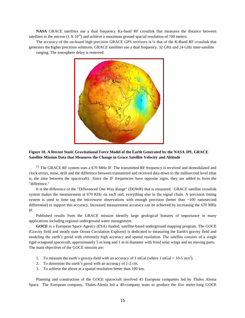
NASA GRACE satellites use a dual frequency Ka-band RF crosslink that measures the distance between
satellites to the micron (1 X 10⁻⁶
) and achieve a maximum ground spacial resolution of 700 meters.
The accuracy of the on-board high precision GRACE GPS receivers is ¼ that of the K-Band RF crosslink that
generates the higher precision solutions. GRACE satellites use a dual frequency, 32 GHz and 24 GHz inter-satellite
ranging. The ionosphere delay is removed.
Figure 10. A Recent Static Gravitational Force Model of the Earth Generated by the NASA JPL GRACE
Satellite Mission Data that Measures the Change in Grace Satellite Velocity and Altitude
[3] The GRACE RF system uses a 670 MHz IF. The transmitted RF frequency is received and demodulated and
clock errors, noise, drift and the difference between transmitted and received data down to the millisecond level (that
is, the time between the spacecraft). Since the IF frequencies have opposite signs, they are added to form the
"difference."
It is the difference or the "Differenced One Way Range" (DOWR) that is measured. GRACE satellite crosslink
system makes the measurement at 670 KHz on each end, everything else in the signal chain. A precision timing
system is used to time tag the microwave observations with enough precision (better than ~100 nanosecond
differential) to support this accuracy. Increased measurement accuracy can be achieved by increasing the 670 MHz
IF.
Published results from the GRACE mission identify large geological features of importance in many
applications including regional underground water management.
GOCE is a European Space Agency (ESA) funded, satellite-based underground mapping program. The GOCE
(Gravity field and steady state Ocean Circulation Explorer) is dedicated to measuring the Earth's gravity field and
modeling the earth’s geoid with extremely high accuracy and spatial resolution. The satellite consists of a single
rigid octagonal spacecraft, approximately 5 m long and 1 m in diameter with fixed solar wings and no moving parts.
The main objectives of the GOCE mission are:
1. To measure the earth’s gravity-field with an accuracy of 1 mGal (where 1 mGal = 10-5 m/s2).
2. To determine the earth’s geoid with an accuracy of 1-2 cm.
3. To achieve the above at a spatial resolution better than 100 km.
Planning and construction of the GOCE spacecraft involved 45 European companies led by Thales Alenia
Space. The European company, Thales-Alenia led a 40-company team to produce the five meter-long GOCE

16
(Gravity field and steady state Ocean Circulation Explorer). The GOCE satellite was launched in March of 2009.
The GOCE satellites have a proposed lifetime of about 20 months.
Figure 11. The ESA GOCE Satellite/Gradiometer during Factory Integration & Test
The ESA/Russian GOCE satellite orbits the earth at an altitude of just 250 km. Its unusual aerodynamic shape
cut through the remains of the atmosphere at 250 km altitude with far less drag than most satellites at the same
altitude due to its narrow and long shape thus decreasing orbit perturbations and increasing accuracy. The low-
orbiting GOCE satellite is the first to employ gradiometry in space to measure the Earth’s gravity gradient.
An on-board laser retro reflector (LRR) enables satellite tracking by terrestrial personnel using lasers. [5]
The
GOCE satellite gradiometer provides data to generate a global model of the Earth’s gravity field with accuracy
better than one mGal for the gravity and less than 2 cm for the geoid, with a spatial resolution of 100 km from the
250 km satellite orbit altitude.
Figure 12. A Recent GOCE Gravitational Force Map of the Earth Generated in March 2011 Using the
GOCE Satellite as a Gradiometer (5 µmeter/sec² = 1 Mgal = 5.1 X 10⁻⁴
G)

17
The ESA GOCE satellite core instrument is the Electrostatic Gravity Gradiometer (EGG) and consists of three
pairs of identical ultra-sensitive accelerometers, mounted on three mutually orthogonal 'gradiometer arms'. The
distance between each sensor pair does not vary by more than 1% of an Angstrom (the diameter of an atom) over a
mean time interval of approximately 3 minutes.
The difference in behavior between the gravity measured by each sensor pair on the GOCE satellite, along the
axis of each of the three arms is used to calculate the Earth's gravity gradient. Within its measurement band, each
GOCE accelerometer can detect accelerations to within 1 part in 10,000,000,000,000 of Earth’s surface gravity.
Figure 13. A Recent Static Map Gravity Force Model Measured By the European Space Agency (ESA)
GOCE
X. Satellite Illustrating the Variations in the Earth’s Mass Density
Grail is the NASA JPL underground mapping mission for the moon planned for launch in 2016. [9]
It is the next
evolutionary step over the NASA JPL GRACE system using a lower orbit altitude to improve measurement
accuracy as the noise level decreases with less atmospheric disturbances.
GRAIL will map the lunar underground from an altitude of 60 Km and will measure the moon’s gravitational
field strength that is ~ 1/6 the strength of the earth’s demonstrating that the sensitivity of the existing NASA JPL
satellite-based underground mapping system instruments can generate usable measurements at 1/6 the earth’s
gravitational force. GRAIL is a lunar-orbiting mission consisting of two co-orbiting mini-satellites.
For a quicker mission and lower program cost, the NASA JPL GRAIL satellites use the same RF microwave
ranging system as the GRACE satellites at a 32 GHz frequency of about one cm, to do the precision distance
measurement between satellites. The standard digital tracking techniques track phase to about 1 x 10⁻⁴
Hz, that is, 1
x 10-6
meters, or one micron.
The NASA JPL's GRAIL's mission duration of 270 days includes a planned launch in September of 2011,
followed by a low-energy trans-lunar cruise for the dual-spacecraft checkout and out-gassing, and a 90 day gravity

18
mapping science phase. Initial science products will be available beginning 30 days after the start of the science
phase and will be delivered to NASA's PDS (Planetary Data System) no later than 3 months after the end of the
science phase.
Figure 14. Artist Concept of the NASA JPL GRAIL Satellites Measuring the Lunar Gravity for Underground
Mapping of the Moon from Space
XI. Increasing The Precision Of Gravity Measuring Instruments Used On The NASA Grace Satellite
Using RF: Today, the NASA GRACE satellites measure the change in the distance between satellites that is
related to a measurement of the earth’s gravity using a Ka-Band RF crosslink. The Ka-band RF crosslink measures
the very small (~ 1 x 10⁻³
meters) change in the distance between on-orbit GRACE satellite as they orbit over the
earth below. An increase in accuracy and sensitivity when measuring the earth’s gravity gradient is possible by
choosing higher RF frequencies for the inter satellite cross link such as 60 GHz including using a higher frequency
IF.
A 60 GHz RF (or higher) frequency cross-link will almost double the sensitivity of the measurement of the
change in distance between satellites from doubling the RF frequency. A 60 GHZ crosslink is feasible because it is
already employed as the RF frequency of choice for inter-satellite cross-links used on military missions. The
moisture in the earth’s atmosphere absorbs most of the 60 GHz RF signal and thus offers security from ground and
air based signal-monitoring systems. Sixty GHz cross-links were planned for use on the U.S. Air Force
Transformational Satellite Communications System (a.k.a. TSAT) that was terminated in 2009. However, much of
the technology is still available.
LASER: A further increase in DUMPSTR satellite distance and velocity measurement sensitivity and precision
can be achieved by using a laser crosslink. Since laser frequency is much higher than RF, the sensitivity of the
measurement of the distance between satellites will greatly increase with the higher frequency of light. Laser cross-
link technology is also available from the TSAT program since TSAT was to rely on both extremely high frequency
(EHF) 60 GHz RF satellite cross-links and laser communications systems for broadband communications.

19
The higher frequencies used on TSAT to terrestrial terminals was chosen to satisfy the military's appetite for
large-bandwidth communications. The TSAT satellite laser terminals were to be the space borne backbone of a
larger network, called the Global Information Grid (GIG) that was to feed information to airborne intelligence assets
and troops on the ground.
The proposed five-satellite TSAT constellation that was use both 60 GHz and laser cross-links was to be
deployed in geostationary orbit to ensure global coverage. DUMPSTR would provide another opportunity to employ
the many RF and laser crosslink systems proposed for use on the TSAT secure and survivable satellite-based
communications system to measure the earth’s gravity gradient at an accuracy to identify underground facilities in
hostile nations.
Using GPS: The change in distance between satellites can also be measured more accurately than the method
employed by GPS. Currently, GPS satellites time-tag the transmission of its user data from each satellite using the
on-board 10.23 MHz atomic clock. Each GPS satellite’s 10.23 MHz frequency standard allows a second of time to
be divided into ~1 x 10⁻⁹
seconds or the GPS nanosecond. The GPS nanosecond is the smallest division of time in
the GPS system. The GPS user receiver also time-tags when the data arrives at the receiver and the distance from the
satellite to the user is accurately determined down to the nanosecond accuracy. The GPS 10.23 MHz atomic clock
time reference can now be replaced using a clock that is derived from an RF signal used in the inter-satellite
crosslink decreasing the GPS nanosecond (~1 x 10⁻⁹
) down far smaller unit of time that is related to the RF
frequency used, thus increasing the accuracy and sensitivity of the distance between satellites measurement.
Higher accuracy measurements of the earth’s gravity can be made from space by measuring gravity from a
satellite lower altitude. The closer to the earth, the stringer the gravitation pull on satellites and so a lower altitude
can be superior to a higher altitude. The NASA GRAIL lunar underground mapping system will orbit the moon at
60 Km, which is much lower orbit altitude than the NASA GRACE satellites, which orbit the Earth at 250 Km.
The moon has much less atmosphere than the earth and the gravity measuring instrument performance
decreases with orbit altitude due to an increase in measurement noise from the impact of an atmosphere with a high-
speed (17,000+ mph) satellite. Since gravity is a 1/r2 force, specific instrument measurement accuracy will decrease
quickly with a change in satellite altitude.
There are other methods feasible to increase the accuracy and sensitivity of the DUMPSTR gravity gradient
measuring instruments. The analysis of these methods can be accomplished in other studies for a later time and is
not being considered for completion in the proposed study that this white paper was submitted to address.
XII. CONCLUSION
A global, real-time satellite-based gravity measuring and monitoring system will allow the earth’s gravity
gradient to be leveraged to monitor the earth’s underground movement to provide the most comprehensive source of
data from underground motion for scientists to predict global earthquakes, identify and track tsunamis and predict
volcano eruptions providing warning from weeks to months. The same measurements can be used to identify the
locations of underground facilities that may store weapons of mass destruction by hostile nations. This data is
essential to U.S. security. It is likely that the ESA/Russian gravity gradient measurement satellite is providing the
information about U.S. underground facilities to hostile nations.
To determine an optimal constellation altitude, a parametric analysis should be completed. The results of a
parametric analysis will identify the gravity gradient measuring sensitivity and accuracy for the instrument
performance needed to exploit the earth’s gravity to identify the potential locations of underground facilities in
hostile nations. The defined performance, the other design parameters can be chosen and a road map can be
developed to develop the instruments necessary to achieve the required performance if existing instrument
performance is inadequate. The space science community has been measuring the earth’s gravity gradient for
science applications for over 10 years and has had highly beneficial results. We want to the U.S. science community
to have access to more complete and precise information possible.
20
The DUMPSTR concept also has a large commercial application. The recent 5.9 earthquake in Virginia
demonstrates that the evolution of the earth’s tectonic motion continues to occur and increasing the east coast of the
U.S. to more earthquakes, increasing the risk to public safety. The information from DUMSTR could be sold
commercially, eventually earning the income to pay for the design and future operations and maintenance cost
worldwide, allowing international earthquake prediction, tsunami identification and tracking and global
communications system for broadcasting the earthquake and tsunami warnings.
REFERENCES
1. Berger, C., R. Biancale, M. Ill and F. Barlier, “Improvement of the Empirical Thermo-spheric Model DTM:
DTM94 -- a Comparative Review of Various Temporal Variations and Prospects in Space Geodesy Applications,”
Journal of Geodesy, 72: pg. 161-178, 1998.
2. Bertiger, W. I., Y. E. Bar-Sever, E. J. Christensen, E. S. Davis, J. R. Guinn, B. J. Haines, R. W. Ibanez-Meier, J.
R. Jee, S. M. Lichten, W. G. Melbourne, R. J. Muellerschoen, T. N. Munson, Y. Vigue, S. C. Wu, and T. P. Yunck,
B. E. Schutz, P. A. M. Abusali, H. J. Rim, M. M. Watkins, and P. Willis, “GPS Precise Tracking of
Topex/Poseidon: Results and Implications,” JGR Oceans Topex/Poseidon Special Issue, vol. 99, no. C12, pg.
24,449-24,464 Dec. 15, 1994.
3. W. Bertiger, Y. Bar-Sever, S. Desai, C. Dunn, B. Haines, G. Kruizinga, D. Kuang, S. Nandi, L. Romans, M.
Watkins, and S. Wu, Jet Propulsion Laboratory, California Institute of Technology.“GRACE: Millimeters and
Microns in Orbit”, Bettadpur, proc from the Center for Space Research
4. Dunn, Charles, Willy Bertiger, Garth Franklin, Ian Harris, Don Nguyen, Tom Meehan, Sumita Nandi, Tim
Rogstad, J. Brooks Thomas, and Jeff Tien, “The Instrument on NASA’s GRACE Mission: Augmentation of GPS to
Achieve Unprecedented Gravity Field Measurements,” Proceedings of ION GPS 2002, Portland OR, September
2002.
5 Jorgensen, John L; Liebe, Carl C; Jensen, Gunnar B; Eisenman, Allan R; ESA International Conference on
Spacecraft Guidance, Navigation and Control Systems, 3rd, Noordwijk, Netherlands, Nov. 26-29, 1996, Proceedings
(A97-40501 11-18), Noordwijk,
Netherlands, ESA, 1997, p 303-308
6. Thomas, J. B., “An Analysis of Gravity-Field Estimation Based on Inter-satellite Dual-1-Way Biased Ranging,”
JPL Publications 98-15, May 1999.
7. Watkins, M. M., E.S. Davis, W.G. Melbourne, T. P. Yunck, J. Sharma, S. Bettadpur, and B. D. Tapley,
“GRACE: A New Mission Concept for High Resolution Gravity Field Mapping”, Proc. of European Geophysical
Society, Hamburg, Germany (1995).
8. Watkins, M. M. and S. V. Bettadpur, “The GRACE Mission: Challenges of Using Micron-Level Satellite-to-
Satellite Ranging to Measure the Earth's Gravity Field”, Proceedings of the International Symposium on Space
Dynamics, Biarritz, France, 26-30 June 2000, Centre National d'Etudes Spatiales (CNES), Delegation a la
Communication (publ.), June 2000.
9. Wu, S. C., T. P. Yunck, and C. L. Thornton, “Reduced Dynamic Technique for Precise Orbit Determination of
Low Earth Orbit”, J. Guid., Control Dyn., 14(1), 24–30, 1991.
10. http://science.nasa.gov/about-us