USING MACRO-LEVEL COLLISION PREDICTION MODELS TO … · 2008-03-20 · potential to reduce...
24
C:\Documents and Settings\gord\My Documents\Research\VTPI Todd Litman\TRB 2008 TDM Safety Benefits_Revised Nov.6.07.tl.grl.final.submitted.doc USING MACRO-LEVEL COLLISION PREDICTION MODELS TO EVALUATE THE ROAD SAFETY EFFECTS OF MOBILITY MANAGEMENT STRATEGIES: NEW EMPIRICAL TOOLS TO PROMOTE SUSTAINABLE DEVELOPMENT Dr. Gordon R. Lovegrove, P.Eng, MBA Assistant Professor, School of Engineering University of British Columbia Okanagan, Kelowna, Canada 3333 University Way, Kelowna, BC, Canada, V1V-1V7 250-807-8717, [email protected] Todd Litman Principal Victoria Transport Policy Institute Victoria, Canada, V8V 3R7 [email protected] Key Words: Land Use Planning Transportation Planning Macro-Level Models Road Safety Planning Collision Prediction Models Mobility Management Strategy Network Exposure Socio-Demographic Transportation Demand Management Word Count = 7,450 words, including 6 tables 6 November 2007 TRB 2008 Annual Meeting CD-ROM Paper revised from original submittal.
Transcript of USING MACRO-LEVEL COLLISION PREDICTION MODELS TO … · 2008-03-20 · potential to reduce...

C:\Documents and Settings\gord\My Documents\Research\VTPI Todd Litman\TRB 2008 TDM Safety Benefits_Revised Nov.6.07.tl.grl.final.submitted.doc
USING MACRO-LEVEL COLLISION PREDICTION MODELS
TO EVALUATE THE ROAD SAFETY EFFECTS OF
MOBILITY MANAGEMENT STRATEGIES:
NEW EMPIRICAL TOOLS TO PROMOTE
SUSTAINABLE DEVELOPMENT
Dr. Gordon R. Lovegrove, P.Eng, MBA Assistant Professor, School of Engineering
University of British Columbia Okanagan, Kelowna, Canada 3333 University Way, Kelowna, BC, Canada, V1V-1V7
250-807-8717, [email protected]
Todd Litman
Principal Victoria Transport Policy Institute
Victoria, Canada, V8V 3R7 [email protected]
Key Words:
Land Use Planning Transportation Planning
Macro-Level Models Road Safety Planning
Collision Prediction Models Mobility Management Strategy
Network Exposure
Socio-Demographic Transportation Demand Management
Word Count = 7,450 words, including 6 tables
6 November 2007
TRB 2008 Annual Meeting CD-ROM Paper revised from original submittal.

Lovegrove & Litman 2
ABSTRACT
Mobility management (also called Transportation Demand Management, or TDM) consists of
various strategies that change travel behaviour to increase transportation system efficiency.
Mobility management policies and programs are generally promoted as ways to reduce traffic
congestion, parking problems and pollution emissions; road safety is seldom a major objective.
However, research described in this paper indicates that mobility management strategies also
provide significant safety benefits. This paper describes how community-based, macro-level
collision prediction models (CPMs) can be used to calculate the road safety effects of specific
mobility management strategies (MMS). It summarizes the results of road safety evaluations of
three mobility management strategies using recently developed macro-level CPMs, and using
data from 479 urban neighbourhoods in the Greater Vancouver Regional District (GVRD), in
British Columbia (BC), Canada. The results suggest that a smart growth strategy of more
compact, multi-modal land use development patterns can reduce per capita neighbourhood
collision frequency by 20% (total) and 29% (severe); that a congestion pricing strategy has the
potential to reduce neighbourhood collision frequency by 19% (total) and 21% (severe); and
improving transportation options (better walking and cycling conditions, and improved
ridesharing and public transit services) could reduce collision frequency by 14% (total) and 15%
(severe). These model predictions are consistent with actual observed mobility management
collision reductions. This study indicates that mobility management strategies can significantly
increase traffic safety in addition to providing other economic and environmental benefits.
TRB 2008 Annual Meeting CD-ROM Paper revised from original submittal.

Lovegrove & Litman 3
INTRODUCTION
Mobility Management includes various strategies that help solve transportation problems by
changing travel behaviour and increasing transportation system efficiencies (3). Mobility
management is generally implemented to reduce traffic congestion, parking problems, energy
consumption and pollution emissions. Mobility Management Strategies (MMS) increase
transport system efficiency by causing various types of changes in travel behaviour, such as (4):
switches in travel mode (e.g. carpooling instead of driving alone), changes in travel time (e.g.
earlier or later travel times, to less congested off-peak periods), and/or changes in work/home
location (e.g. working closer to home). Many of the local, regional, and global benefits of these
changes in travel behaviour have been extensively researched (4, 5, 6, 7, 8). However, many
politicians, businesses, and residents remain reluctant to support mobility management policies
and programs, apparently because they consider the overall benefits smaller than the incremental
implementation costs (9, 10, 11, 12, 13).
There is still some debate among researchers as to the magnitude of mobility management
benefits (5, 9), due, in part, to the lack of reliable empirical tools for predicting how MMS cause
transportation system changes (14, 15). Mobility management impacts have generally been
quantified using conventional four-step transportation planning or activity-based models, which
have been shown to have significant errors, leading to over and/or underestimation of MMS
effectiveness (15). In addition, many mobility management policies and programs take several
years for full implementation, require program compromises during the approval process, and
then are superimposed after unforeseen changes to the subject land use and transportation
systems. Thus, it can be difficult to isolate the effects of MMS from other trends and system
changes. Because some MMSs involve new investments, higher user fees or vehicle use
restrictions, mobility management program implementation must overcome the uncertainty of
benefits.
For these reasons, mobility management implementation is often difficult, even when such
policies and programs are cost effective solutions to widely recognized problems such as traffic
and parking congestion, excessive energy consumption and pollution emissions (16). Unless a
TRB 2008 Annual Meeting CD-ROM Paper revised from original submittal.
Lovegrove & Litman 4
clear self-interest can be perceived (i.e. it is in my best interest to change my behaviour) people
are reluctant to support policies that will force them to change their behaviour.
In summary, there appear to be three basic barriers to optimal mobility management
implementation:
1) a lack of reliable empirical tools to accurately predict the benefits of MMSs; leading to,
2) a lack of defendable data with which decision-makers can justify implementing mobility-
reducing MMSs; leading to,
3) a lack of public support for mobility management implementation.
Recent results in sustainable road safety research (1, 2) may help solve this problem by
expanding the list of mobility management benefits to include road safety.
The enormity of the social and economic burden of road collisionsis a major problem worldwide.
In 2004 the World Health Organization declared injuries due to road collisions as one of the
leading epidemics of our time (17). The United Nations has made a similar declaration for 2007
(18). In the United States, more productive years of life are lost due to road collisions than any
other disease, more than heart disease and cancer combined (20). In Canada, approximately
60,000 road collisions were reported in 2003, resulting in over 200,000 people injured and 3,000
people killed (19). At current trends injuries due to road collisions will be the third leading cause
of death worldwide by 2020 (17). In addition to the human cost, these road casualties put an
enormous economic burden on society, estimated to range from 1% to 2% of gross national
product worldwide, estimated to total US$518 billion in 2004 (17).
Most Road Safety Improvement Programs (RSIPs) focus on engineering, enforcement, and/or
education to reduce collisions and casualty rates per vehicle mile or kilometre. The most
effective, long-lasting road safety strategies tend to be those that focus on engineering safer road
environments that lead to a reduction in exposure and risk of collision for drivers and their
passengers (21). Traditionally, the engineering of safer roads has taken a reactive approach,
including the identification, diagnosis and remedy (“improvement”) of hazardous or collision-
prone locations (called “black spots”), implementing remedial treatments after safety problems
TRB 2008 Annual Meeting CD-ROM Paper revised from original submittal.

Lovegrove & Litman 5
were identified (21). Unfortunately, this reactive approach requires several years of collision
records, along with the associated toll in human casualties, before a safety problem is identified
and fixed, often at a high cost in existing communities.
Given the continuing burden of injuries due to road collisions, practitioners have been pursuing a
more proactive approach, to evaluate road safety before problems occur, as part of the land use
and/or transportation planning process (19, 21). However, until recently practitioners lacked the
necessary empirical tools to evaluate road safety proactively. Recent research on Sustainable
Road Safety (SRS) (1, 2), has resulted in the development of improved empirical tools to do
pursue proactive road safety, including community-based, macro-level collision prediction
models (CPMs). In several case studies to date, these CPMs and model-use guidelines has
demonstrated their potential for use to improve road safety in communities across Canada and
the world (1). These new empirical tools present an opportunity to verify earlier research on, and
refine estimates of, the road safety effects of MMSs.
Traffic monitoring after the implementation of certain mobility management strategies indicates
that they can provide significant road safety benefits (1, 4). If true, this is good news, because it
identifies a new set of potential road safety strategies that provide a variety of sustainable
development planning benefits to society, as indicated in Table 1.
This paper has two main objectives:
(1) To demonstrate the use of previously developed macro-level collision prediction models
(CPMs) to provide empirical road safety estimates in a case study; and,
(2) To empirically verify earlier road safety estimates for three mobility management
strategies (MMSs).
PREVIOUS WORK
Due to a lack of reliable empirical tools, limited research exists on the road safety effects of
mobility management strategies (1, 2, 4). A comprehensive literature review (4) of various
mobility management strategies found that much of the data were improperly aggregated, and
models failed to correct for potentially confounding factors. For example, we generally know
TRB 2008 Annual Meeting CD-ROM Paper revised from original submittal.

Lovegrove & Litman 6
that a reduction in one person’s vehicle mileage should provide a reduction in their individual
collision risk (1, 2). And, we also know that in the range of 70% of all severe collisions involve
multiple vehicles; therefore, we can hypothesize that some further reduction in the collision risk
of other motorists (regardless of whether or not they reduce mileage) should occur also, since
their vehicles are exposed less to this drivers’ errors (1, 2, 4). However, limited research has
produced limited findings, particularly at a fine-grained scale, thus precluding the ability to
confirm this hypothesis until recently. With the advent of community-based, macro-level
collision prediction models, reliable empirical evaluations of mobility management strategies
appear possible.
By definition, macro-level CPMs evaluate the safety of a neighbourhood, a city, or a region
using neighbourhood traits as inputs (e.g. population density, intersection density, mode split,
traffic density). Based on Dutch research from the mid-1990’s, two North American researchers
developed early version (22, 23), but neither attempted to use CPMs in road safety evaluations.
In 2006, using a refined methodology, researchers (2) developed forty-seven community-based,
macro-level collision prediction models, each significantly associated with one or more of
twenty-two input variables. For each neighbourhood, which were typically defined to coincide
with traffic analysis zones (TAZs) used in regional transportation planning models (e.g. Emme/2
in the GVRD), input variable values were obtained using aggregated data off of geo-referenced
travel demand, demographic, and road network mapping (e.g. ArcGIS) provided by regional
road, land use, census, and auto insurance authorities (1). The CPMs output a prediction of the
number of collisions that can be reasonably expected to occur in that same neighbourhood (or
TAZ) per unit time (e.g. every three years). Samples of the models developed and used in this
case study are given in Table 2, with descriptive statistics and input data in Table 5 (2).
Contrary to traditional linear collision prediction models that had been assumed until recently by
Dutch and other researchers, the non-linear form of these empirically derived macro-level CPMs
in Table 2 (1, 2) confirmed that collision frequency was non-linearly related to Vehicle
Kilometres Traveled (VKT). In other words, whereas traditional linear CPMs associated
collisions linearly with VKT (e.g. Collision frequency = collision rate x VKTPower = 1.0), these
newly developed CPMs associated collisions non-linearly with VKT (e.g. Collision frequency =
TRB 2008 Annual Meeting CD-ROM Paper revised from original submittal.

Lovegrove & Litman 7
proportionality constant x VKTPower < 1.0), with the power of the VKT exponent ranging from 0.55
to 0.85. Generalized linear regression modelling (GLIM) techniques were used to develop and
calibrate these CPMs, including an assumed negative binomial residual statistical pattern
distribution, a 95% level of confidence statistical test, and the Pearson and Chi-square model
goodness-of-fit statistical tests. All developed models met these tests, and were categorized for
use into one of sixteen groups shown in Table 3 (2), based on the following factors:
• Four themes of neighbourhood traits (exposure or traffic density, road network, socio-
demographics, and TDM).
• Two classes of predominant land use (rural or urban). Urban includes urban and suburban.
• Two sources of exposure variable data derivations (modelled or measured). Modelled
exposure variables were outputted from transportation planning models, such as Emme/2
(e.g. VKT). Measured exposure variables (e.g. Total Lane Kilometres = TLKM) were
derived from geo-coded mapping.
Generally, these newly developed macro-level collision prediction models have found observed
effects consistent with intuition. Specifically, increased collisions are non-linearly associated
with increases in the following explanatory variables:
• Exposure - vehicle kilometres travelled (VKT), total road lane kilometres (TLKM), and
average congestion (VC).
• Socio-Demographic - job density (WKGD), population density (POPD), unemployment
(UNEMP), residential unit density (NHD).
• TDM – shortcut capacity/attractiveness (SCC, SCVC), number of drivers (DRIVE), total
commuters (TCM), total commuter density (TCD). SCC measures the ability of vehicles
to shortcut on local roads through a particular zone, in vehicles per hour. SCVC is
simply SCC multiplied by congestion level VC.
• Network - signal density (SIGD), intersection density per unit area (INTD), intersection
density per lane-km (INTKD), arterial-local intersection percent (IALP), arterial lane
kilometre percent (ALKP).
TRB 2008 Annual Meeting CD-ROM Paper revised from original submittal.
Lovegrove & Litman 8
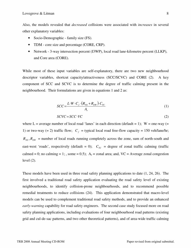
Also, the models revealed that decreased collisions were associated with increases in several
other explanatory variables:
• Socio-Demographic - family size (FS).
• TDM - core size and percentage (CORE, CRP).
• Network - 3-way intersection percent (I3WP), local road lane-kilometre percent (LLKP),
and Core area (CORE).
While most of these input variables are self-explanatory, there are two new neighbourhood
descriptor variables, shortcut capacity/attractiveness (SCC/SCVC) and CORE (2). A key
component of SCC and SCVC is to determine the degree of traffic calming present in the
neighbourhood. Their formulations are given in equations 1 and 2 as:
( )
r
TCEWNSf
A
CRRCWLSCC
⋅+⋅⋅⋅= (1)
VCSCCSCVC ⋅= (2)
where L = average number of local road ‘lanes’ in each direction (default = 1); W = one-way (=
1) or two-way (= 2) traffic flow; fC = typical local road free-flow capacity = 150 veh/lane/hr;
EWNS RR , = number of local roads running completely across the zone, sum of north-south and
east-west ‘roads’, respectively (default = 0); TCC = degree of zonal traffic calming (traffic
calmed = 0; no calming = 1; , some = 0.5); Ar = zonal area; and, VC = Average zonal congestion
level (2).
These models have been used in three road safety planning applications to date (1, 24, 26). The
first involved a traditional road safety application evaluating the road safety level of existing
neighbourhoods, to identify collision-prone neighbourhoods, and to recommend possible
remedial treatments to reduce collisions (24). This application demonstrated that macro-level
models can be used to complement traditional road safety methods, and to provide an enhanced
early-warning capability for road safety engineers. The second case study focused more on road
safety planning applications, including evaluations of four neighbourhood road patterns (existing
grid and cul-de-sac patterns, and two other theoretical patterns), and of area-wide traffic calming
TRB 2008 Annual Meeting CD-ROM Paper revised from original submittal.

Lovegrove & Litman 9
(repeating a 10 year old conventional study, but using only the before data with the new models
to predict the after results). The third case study used the models to evaluate the road safety
effects of a regional transportation plan. These studies were used to demonstrate that macro-
level CPM predictions are practical to use in local and regional planning processes, and to
predict the road safety levels for both existing and planned neighbourhoods. In effect, this also
demonstrated a method of using these new models to do a sensitivity analysis of the road safety
impacts of varying certain neighbourhood design features, within certain guidelines. Based on
the results of these case studies, model-use guidelines for using macro-level CPMs have been
prepared (1).
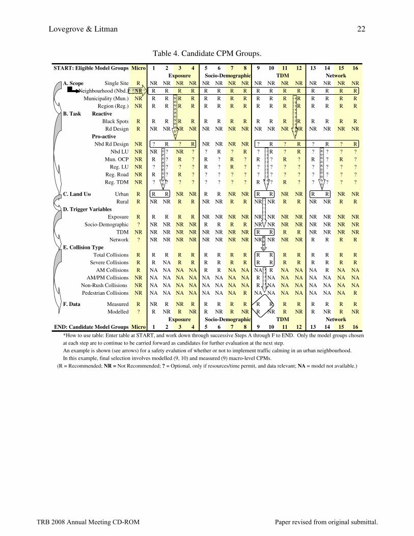
The macro-level CPM use guidelines pertain to the selection of which of the forty-seven models
to use, techniques to conduct the actual analysis, and proper statistical tests and interpretation of
results. As not every macro-level CPM was appropriate for each safety application, a six-step
selection process has been recommended, and was followed in this case study. The first step
involved choosing the CPM type (i.e. micro- or macro-level) based on the scope of the safety
evaluation. MMSs usually affect entire neighbourhoods (i.e. traffic zones), a municipality, or
part of a region (as opposed to a single intersection, for which micro-level CPMs are used);
therefore, macro-level CPMs were used. The second step narrowed the model focus by
considering the safety application task, which in this application was proactive (i.e. MMS plan).
Therefore, only some of the sixteen groups were appropriate. The third step looked at the
predominant type of land use in each neighbourhood under evaluation, which in this case was
urban, suggesting that only urban CPMs be used. The fourth step looked at the specifics of the
analysis to identify which input variables would be changing with each MMS. These changing
variables were termed trigger variables, and depend on planning scope (e.g. present situation to
future conditions, future vs future scenario comparisons), and the specifics of the planning
schemes involved. For example in this case, MMSs would be expected to reduce driving,
exposure, and congestion levels, suggesting that VKT, VC, and DRIVE would be trigger
variables. These trigger variables are found in the urban TDM models (i.e. groups 9 and 10 in
Table 3). Other triggers variables and models used to evaluate MMS are detailed below in the
approach to the case study.
TRB 2008 Annual Meeting CD-ROM Paper revised from original submittal.
Lovegrove & Litman 10
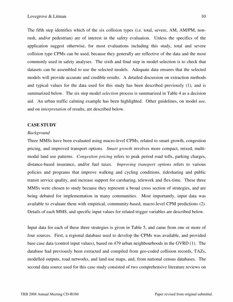
The fifth step identifies which of the six collision types (i.e. total, severe, AM, AM/PM, non-
rush, and/or pedestrian) are of interest in the safety evaluation. Unless the specifics of the
application suggest otherwise, for most evaluations including this study, total and severe
collision type CPMs can be used, because they generally are reflective of the data and the most
commonly used in safety analyses. The sixth and final step in model selection is to check that
datasets can be assembled to use the selected models. Adequate data ensures that the selected
models will provide accurate and credible results. A detailed discussion on extraction methods
and typical values for the data used for this study has been described previously (1), and is
summarized below. The six step model selection process is summarized in Table 4 as a decision
aid. An urban traffic calming example has been highlighted. Other guidelines, on model use,
and on interpretation of results, are described below.
CASE STUDY
Background
Three MMSs have been evaluated using macro-level CPMs, related to smart growth, congestion
pricing, and improved transport options. Smart growth involves more compact, mixed, multi-
modal land use patterns. Congestion pricing refers to peak period road tolls, parking charges,
distance-based insurance, and/or fuel taxes. Improving transport options refers to various
policies and programs that improve walking and cycling conditions, ridesharing and public
transit service quality, and increase support for carsharing, telework and flex-time. These three
MMSs were chosen to study because they represent a broad cross section of strategies, and are
being debated for implementation in many communities. Most importantly, input data was
available to evaluate them with empirical, community-based, macro-level CPM predictions (2).
Details of each MMS, and specific input values for related trigger variables are described below.
Input data for each of these three strategies is given in Table 5, and came from one or more of
four sources. First, a regional database used to develop the CPMs was available, and provided
base case data (control input values), based on 479 urban neighbourhoods in the GVRD (1). The
database had previously been extracted and compiled from geo-coded collision records, TAZs,
modelled outputs, road networks, and land use maps, and, from national census databases. The
second data source used for this case study consisted of two comprehensive literature reviews on
TRB 2008 Annual Meeting CD-ROM Paper revised from original submittal.

Lovegrove & Litman 11
observed transportation changes due to various MMSs (3, 4, 25). Third, data from recent road
safety research (1) on the observed traffic impacts of traffic calming was used to augment smart
growth impacts. Fourth, because data for these three MMSs was not yet available via the GVRD
regional four-step transportation planning model, data for the modeled variables VKT and VC
were based on values found in the literature. Although this introduced an obvious source of
uncertainty into the study input values, using values from the literature was considered a
reasonable proxy, and at least provided the general domain of inputs. Moreover, the focus of this
study was on demonstrating the use of collision prediction models in evaluating MMSs assuming
that the modeled data had already been generated, not on demonstrating the use of four-step
models. A road safety planning case study combining a regional transportation planning (i.e.
four-step) model process with a community-based, macro-level CPM to conduct an MMS
evaluation on a regional scale is the subject of a forthcoming technical journal article (26).
Approach
The general approach - selection, analysis, and interpretation - followed the recommended
guidelines (1). First, the urban planning MMS nature of the application, the availability of
datasets, and the input variables triggered by each MMS prompted use of urban measured and
modelled CPMs for total and severe collisions from the socio-demographic, TDM, and network
models (model groups 5, 6, 9, 10, 13, and 14). Trigger variables were identified for each MMS
according to what impacts have been observed in other research (3, 4, 25). Impacts of a smart
growth MMS were expected to trigger changes in fourteen input (trigger) variables - Exposure:
VKT (decrease), TLKM (decrease), VC (decrease); Socio-demographic: POPD (increase),
WKGD (increase), NHD (increase); TDM: SCC (decrease), CORE (increase), DRIVE
(decrease); and, Network: SIGD (decrease), I3WP (increase), INTD (increase), ALKP
(decrease), and LLKP (increase). The transport improvement MMS triggered changes in four
variables - Exposure: VKT (decrease), VC (decrease); and, TDM: DRIVE (decrease), and TCM
(decrease). The Pricing MMS triggered changes in only three variables - Exposure: VKT
(decrease), VC (decrease); and, TDM: DRIVE (decrease). After identifying the trigger variables,
the macro-level CPMs were run.
TRB 2008 Annual Meeting CD-ROM Paper revised from original submittal.

Lovegrove & Litman 12
The analysis stage involved a three-step road safety evaluation. First, the eleven selected models
were run using the base data for all 479 neighbourhoods to produce GVRD collision frequency
averages for each model. Second, the values of previously identified trigger variables were
adjusted to reflect the literature on MMS effects. Third, these new values for trigger variables
were inputted into the same macro-level CPMs, which were re-run. Table 5 shows the averages
for GVRD input variable values, together with the adjustments to trigger variable values for each
mobility management strategy.
The resulting macro-level CPM predictions were compared to the GVRD averages for each
model group, and differences noted. The differences were reviewed for reasonableness, and
statistical significance using a t-test at 95% confidence interval. It is important to note that, in
accord with model use guidelines, the macro-level CPM predictions were used for relative
comparisons only, pending further research and model refinements. Using the absolute model
predictions, except to analyze individual or small groups of neighbourhoods, is not
recommended, as the community-baesd, macro-level CPMs by definition exclude major
highways (i.e. freeways) from their predictive capabilities.
RESULTS
The results of this analysis are presented in Table 6. They appear to be in general agreement
with intuitive expectations, and with safety impacts observed in the literature (1, 4). In
accordance with model use guidelines on interpretation of results, these model predictions were
tested for statistical significance, recognizing that macro-level CPM predictions are only
expected values. That is, their predictions are estimates of the true mean frequency of collisions,
which is a random variable. Given this randomness, standard statistical testing was used to
verify whether the GVRD base case averages were significantly different from the MMS-
adjusted predictions. A difference of means hypothesis test was used, which relies on a normally
distributed test statistic, T, calculated according to a 95% confidence interval. The difference
was significant if the calculated T-test statistic met the criterion in equation 3, as follows (27):
]1,2
)1([][
])[(
−−≥
−−
nT
n
sDifferenceDevStd
sDifferenceofAvgAvgGVRDAvgMMSα (3)
TRB 2008 Annual Meeting CD-ROM Paper revised from original submittal.

Lovegrove & Litman 13
where:
n = the number of model predictions used in deriving the comparison
α = the desired confidence interval, in this case 95%
T = 1.96 @ 95% for large n, derived from standard T-distribution tables
][ sDifferenceDevStd = the standard deviation of the differences predicted
across all models.
For the urban smart growth MMS, improvements in road safety were estimated for total and
severe collisions to be in the range of 20% and 29%, respectively, when compared with GVRD
urban neighbourhood averages. This result is considered statistically significant using a 95%
confidence interval. It is also in general agreement with the 20% road safety improvements of
MMSs observed by other researchers (4, 28, 29). For the congestion pricing MMS,
improvements in road safety were estimated for total and severe collisions to be in the range of
19% and 21%, respectively, when compared with GVRD urban neighbourhood averages. This
result is considered statistically significant using a 95% confidence interval. It is also in general
agreement with the 25% road safety improvement of road pricing MMSs observed by other
researchers. The transit improvement were estimated to reduce total and severe collisions in the
range of 14 and 15%, respectively, when compared with GVRD urban neighbourhood averages.
This result is considered statistically significant using a 95% confidence interval. It is also in
general agreement with the road safety impacts of MMSs observed by other researchers.
Overall, the observed 1:1 to 2:1 relationship between road safety improvement and modeled
variable (i.e. VKT, VC) input values suggests that any reduction in VKT due to MMSs will
result in a road safety benefit. Although a full four-step transportation planning model was not
part of this study and thereby necessitated making assumptions for VKT and VC input values,
which therefore precludes definitive empirical MMS estimates, the results in general suggest that
effective MMSs could significantly augment urban road safety strategies. Comparing the input
exposure variable values from Table 5 with the output safety improvements in Table 6 of all
three strategies, the Smart Growth strategy yielded the highest predicted total (20%) and severe
(29%) collision reductions, despite having the lowest inputted reduction in VKT (-15%). Thus,
it would appear that integrated MMSs that combine land use with transportation management
TRB 2008 Annual Meeting CD-ROM Paper revised from original submittal.

Lovegrove & Litman 14
strategies appeared to provide greater reductions in collisions per unit of reduced VKT compared
with less integrated, single-focused MMSs.
It is also noteworthy that although increased land use intensity (i.e. housing and population
densities), were generally associated with increased collision frequency (1), Smart Growth
policies were predicted to reduce collision frequency. This counter-intuitive result occurred in
this case, however, because Smart Growth strategies reduce VKT as well as increasing
population and housing density. Moreover, the overall reduction in VKT, which is the dominant
variable associated with collision predictions, more than compensated for the population and
housing density increases, and lends additional support to a conclusion supporting integrated,
multi-faceted MMSs as yielding greater road safety benefits than narrower, single-focus MMSs.
OTHER IMPACTS TO CONSIDER
Mobility management strategies (MMS) can have diverse economic, social and environmental
impacts (benefits and costs) which should be considered in their evaluation (3, 30, 31). Most
MMSs reduce traffic congestion, road and parking facility costs, consumer transportation
expenses, energy consumption and pollution emissions, as well as improving mobility options
for non-drivers, and supporting strategic land use objectives (such as redeveloping existing
communities and reducing sprawl). Strategies that increase walking and cycling activity tend to
increase public fitness and health.
On the other hand, some MMSs impose additional external costs, such as increased noise from
buses, and increased sprawl if telecommuting stimulates more dispersed land use development
patterns. MMSs that apply negative incentives, such as increased fuel taxes, road tolls and
parking fees, reduce user mobility benefits although the incremental losses are marginal, since,
with efficient pricing, the travel foregone consists of consumers’ least valued vehicle-kilometres.
Many MMSs provide positive incentives, such as improved travel options (better walking and
cycling conditions, improved rideshare and public transit services, more support for flex-time
and telework) or financial rewards for reduced driving (for example, pay-as-you-drive vehicle
insurance pricing and parking cash-out offer motorists a new opportunity to save money if they
reduce their mileage – motorists who continue their current mileage are no worse off on average,
TRB 2008 Annual Meeting CD-ROM Paper revised from original submittal.

Lovegrove & Litman 15
and those who reduce their mileage save more money than under current pricing). Vehicle travel
reductions that result from these optional, positive incentives reflect net user benefits (consumers
who choose them must be directly better off overall or they would not choose the option, even if
they choose slower modes or alternative destinations).
In some cases, shifts from driving to walking and/or cycling increase crash risk per passenger-
kilometre, although this is often offset by reductions in travel distance (a short walking or
cycling trip often substitutes for a longer automobile trip; although drivers and non-drivers tend
to make similar numbers of trips, drivers trend to travel about three times as many annual
passenger-kilometres as non-drivers). As non-motorized travel increases in a community,
collisions per passenger-kilometre of these modes has been observed to decline (4). All of these
factors should be considered when evaluating the overall value of MMSs.
CONCLUSIONS
This case study has demonstrated the use of previously developed community-based, macro-
level collision prediction models (CPMs) to provide empirical road safety estimates, and to
verify earlier road safety estimates for three mobility management strategies (MMSs). It is the
first empirical road safety evaluation of MMSs using CPMs. Based on a review of the results of
this case study, the following conclusions can be drawn:
1. There is relatively close agreement between the observed (and intuitive expectations) and
predicted mobility management road safety benefits. Transportation and land use factors that
tend to reduce vehicle travel appear to reduce collision frequency.
2. In comparing the inputs and results in Tables 5 and 6, it would appear that integrated MMSs
that combine land use with transportation management strategies appear to provide greater
reductions in collisions per unit of reduced vehicle travel compared with less integrated,
single-focused MMSs.
3. Although the dominant influence of VKT on collision prediction has been noted by other
researchers, these case studies suggest that it may also hold potential when estimating the
road safety impacts of MMSs. This may be used as a convenient proxy by engineers,
TRB 2008 Annual Meeting CD-ROM Paper revised from original submittal.

Lovegrove & Litman 16
planners, and decision-makers for predicting safety impacts of specific policies and
programs.
4. Although increased land use intensity has been generally associated with increased collision
frequency (2), Smart Growth policies are predicted to reduce collision frequency, because
they reduce vehicle-kilometres-travelled (VKT) as well. This result lends additional support
to the second conclusion that integrated, multi-faceted MMSs appear to yield greater road
safety benefits than single-focused MMSs.
When evaluating road safety impacts it is important to clearly define the reference units used.
The traditional practice of predicting collisions per unit of VKT (e.g., per 100 million vehicle-
miles or billion vehicle-kilometres travelled) ignores increases in per capita vehicle travel as a
risk factor and the possible safety benefits of mileage reductions. Similarly, the Smart Growth
MMS is associated with reduced collision frequency and casualties, likely due to reduced per
capita vehicle travel and traffic speeds. Since road safety, and MMSs are ultimately concerned
with people, future research on macro-level CPMs for evaluating the road safety risk of MMSs
should also explore other forms of exposure variables, perhaps those explicitly focused on some
form of per capita travel consumption (e.g. VKT per capita), as is done with health risks for
example, so that road safety risk could be compared with other health risks.
In summary, the results of this empirical road safety evaluation suggest that MMSs have the
potential to increase road safety in addition to providing other significant economic, social and
environmental benefits. It is hoped that the introduction of community-based, macro-level CPM
use by practitioners will facilitate improved road safety analyses by community planners and
engineers. If so, these improved decisions will facilitate improved neighbourhood road safety,
quality of life, and other benefits for residents and road users. Future research will focus on
refining estimates of the modeled inputs (i.e. VKT, VC) associated with each MMS.
Subsequently, case studies are being pursued to develop and transfer macro-level CPMs for use
in other regions on MMS and other road safety evaluations.
TRB 2008 Annual Meeting CD-ROM Paper revised from original submittal.

Lovegrove & Litman 17
REFERENCES
1. Lovegrove, G.R. & Sayed, T. (2006) Using Macro-Level Collision Prediction Models in
Road Safety Planning Applications, Transportation Research Record No 1950, August 2006, pp. 73 - 82.
2. Lovegrove, G.R. & Sayed, T. (2006) Macro-Level Collision Prediction Models for
Evaluating Neighbourhood Traffic Safety, Canadian Journal of Civil Engineering, 33:5, pp. 609-621, May 2006, Vancouver, BC.
3. VTPI (2006) Online TDM Encyclopaedia, Victoria Transport Policy Institute (www.vtpi.org).
4. Litman, T. & Fitzroy, S. (2006) Safe Travels: Evaluating Mobility Management Traffic
Safety Impacts, Victoria Transport Policy Institute (www.vtpi.org). A version of this paper was presented at the Transportation Research Board 2006 Annual Meeting.
5. Institute of Transportation Engineers (1993) Implementing Effective Travel Demand
Management Measures: A Series on TDM, Institute of Transportation Engineers, Washington, D.C., pages 3-93 to 3-112.
6. Mildner, Gerard C.S. & Strathman, James G. & Bianco, Martha J. (1997) Parking Policies
and Commuting Behavior, Transportation Quarterly, Vol. 51, No. 1, Winter 1997 (111 – 125).
7. Rutherford, G. Scott & Badgett, Shauna I. & Ishimaru, John M. & MacLachlan, Stephanie (1993) Transportation Demand Management: Case Studies of Medium-Sized Employers, Transportation Research Record No 1459, Transportation Research Board, Washington, DC, pp. 7 - 16.
8. Wilhelm, Astrid & Posch, Karl-Heinz (2003) Mobility Management Strategies for the Next
Decades: Findings & Recommendations from Largest European Mobility Management
Project, Transportation Research Record No 3703, Transportation Research Board, Washington, DC, pp. 173 - 181.
9. Ferguson, Erik (1999) The Evolution of Travel Demand Management, Transportation Quarterly, Vol. 53, No. 2, Spring 1999, pp. 57-78, Eno Foundation, Washington, DC.
10. Dunn Jr., James A. (1998) Driving Forces: The Automobile, Its Economics and the Politics
of Mobility, The Brookings Institution Press, Washington, DC.
11. Koltzow, K. (1993). Road Safety Rhetoric Versus Road Safety Politics, Accident Analysis and Prevention, 25(6), Elsevier Ltd, Amsterdam, The Netherlands, pp. 647-657.
12. Nelson, Dick & Niles, John S. (1999) Market Dynamics and Nonwork Travel Patterns:
Obstacles to Transit-Oriented Development? Transportation Research Record No 1669, Transportation Research Board, Washington, DC, pp. 13-21.
TRB 2008 Annual Meeting CD-ROM Paper revised from original submittal.

Lovegrove & Litman 18
13. Brown, Ivan (1992). Conflicts Between Mobility, Safety and the Environmental Preservation
Expressed as a Hierarchy of Social Dilemmas, IATSS Research, 16(2), pp. 124-8.
14. Marshment, Richard (2000) Millennium Paper: Transportation Planning Challenges and
Opportunities, Transportation Research Board Committee A1C07 on Transportation Planning Applications, Washington, D.C.
15. Cervero, Robert (2006) Alternative Approaches to Modeling the Travel-Demand Impacts of
Smart Growth, Journal of the American Planning Association, Vo. 72, No. 3, Summer 2006, American Planning Association, Chicago, Il.
16. Button, Kenneth (1994) Alternative Approaches Toward Containing Transport Externalities:
An International Comparison, Transportation Research –A, 28 (4), pp. 289-305.
17. World Health Organization (2004) World report on road traffic injury, World Health Organization/World Bank, [online] Available from http://www.who.int/world-health-day/2004/en/index.html [accessed June 13, 2007].
18. United Nations (2007) United Nations Road Safety Collaboration, The United Nations, April [online] Available from http://www.who.int/roadsafety/week/en/ [accessed June 13, 2007].
19. Transport Canada (2005) Canadian motor vehicle traffic collision statistics: 2003 [online]. Available from http://www.tc.gc.ca/roadsafety/tp/tp3322/page1.htm [accessed June 13, 2007]
20. US Department of Transport (2001) Safety Conscious Planning: Parts 1, 2, and appendices, Federal Highway Administration [online] Available from http://www.fhwa.dot.gov/planning/scp/ec041scp1.htm [accessed June 13, 2007].
21. de Leur, P. and Sayed, T. (2003) A Framework to Proactively Consider Road Safety Within
the Road Planning Process, Canadian Journal of Civil Engineering, 30:4, 711-719.
22. Hadayeghi, Alireza, Shalaby, Amer S., and Persaud, Bhagwant N. (2003). Macro-Level
Accident Prediction Models for Evaluating the Safety of Urban Transportation Systems, Presented at Transportation Research Board Annual Meeting, January, TRB, Washington, D.C.
23. Ladron de Guevara, Felipe, Washington, Simon P., and Oh, Jutaek (2004). Forecasting
Crashes at the Planning Level: A Simultaneous Negative Binomial Crash Model Applied in
Tucson, Arizona, Presented at Transportation Research Board 2004 Annual Meeting, January, TRB, Washington, D.C.
24. Lovegrove, Gord & Sayed, Tarek (2007) Using Macro-Level Collision Prediction Models to
Enhance Traditional Reactive Road Safety Improvement Programs, [pending publication], Transportation Research Board, Transportation Research Record, Washington, D.C.
25. Lovegrove, Gordon (2000) Transportation Demand Management: State of the Debate, University of British Columbia, [unpublished], Vancouver, B.C., December.
TRB 2008 Annual Meeting CD-ROM Paper revised from original submittal.

Lovegrove & Litman 19
26. Lovegrove, Gordon & Lim, Clark & Sayed, Tarek (2008) Sustainable Regional Road Safety
Planning using Macro-Level Collision Prediction Models, to be presented at the January 2008 annual meeting of the Transportation Research Board, Washington, DC.
27. Johnson, Richard A. (2005) Miller & Freund’s Probability & Statistics for Engineers, 7th
Edition, Upper Saddle, NJ, Pearson Education, Inc.
28. Vickrey, William (1968), Automobile Accidents, Tort Law, Externalities, and Insurance: An
Economist’s Critique, Law and Contemporary Problems, 33, pp. 464-487; available at the Victoria Transport Policy Institute website, www.vtpi.org.
29. Edlin, Aaron and Karaca-Mandic, Pena (2002) The Accident Externality from Driving. The Berkeley Electronic Press (www.bepress.com), March.
30. TRIMMS (Trip Reduction Impacts of Mobility Management Strategies) Model, University of South Florida (www.nctr.usf.edu).
31. Litman, Todd (2007) Guide to Calculating Mobility Management Benefits, Victoria Transport Policy Institute (www.vtpi.org); at www.vtpi.org/tdmben.pdf.
Table 1. Comparing Strategies (3)
Sustainability Objectives Mobility
Management
Road Strategies
Collision Reductions � � Congestion Reductions � Roadway and Parking Cost Savings � Consumer Costs Savings � � Improved Mobility Options � Energy Conservation � Pollution Reduction � Physical Fitness & Health �
Land Use Objectives �
Community Liveability � �
Mobility management can help achieve a variety of planning objectives (�).
Traditional road safety strategies typically provide fewer total benefits.
TRB 2008 Annual Meeting CD-ROM Paper revised from original submittal.

Lovegrove & Litman 20
Table 2. Sample of models used to evaluate the road safety level of MMSs (2)
Model Group #
Model Form
κ
DoF
Pearson
χ2
SD χ
2
0.05, dof
1 Urban, Modeled, Exposure 1.7 459 495 508 510
evc
VKTyrCollisionsTotal45.1685.015.13/ =
1.5 461 447 520 512
evc
VKTyrCollisionsSevere087.27265.016154.03/ =
6 Urban, Measured, Socio-Demographic 1.6 463 508 518 514
( )
efsunemppopd
TLKMyrsCollisionsTotal743.006295.0007462.08218.02175.743/
−+⋅=
1.3 464 437 532 515
( )
efsunemppopd
TLKMyrsCollisionsSevere5637.007899.00068.08532.03645.83/
−+⋅=
10 Urban, Measured, TDM 1.5 460 484 517 511
etcmcorescc
TLKMyrsCollisionsTotal)000123.00000277.002702.0(5762.07285.433/
+−⋅=
1.2 461 433 532 512
etcmcorescc
TLKMyrsCollisionsSevere)0000909.00000334.001918.0(7205.02283.73/
+−⋅=
A definition of each variable used in these models is given in Table 3. κ is a model overdispersion parameter derived in CPM development. DoF refers to degrees of freedom, related to the number of data points in model development Pearson χ
2 is a standard statistical test of model goodness of fit
SD refers to scaled deviance, another model goodness of fit measure
χ2 is the target Chi-Square statistic, against which the Pearson and SD measures are tested.
TRB 2008 Annual Meeting CD-ROM Paper revised from original submittal.

Lovegrove & Litman 21
Table 3. Vancouver – Macro-Level Collision Prediction Model Categories (2)
Themes (traits) Neighbourhood input variables
Urban
/Rural
Modeled /
Measured
Group #
Modelled 1 Urban Measured 2
Modelled 3
Exposure Variables VKT = vehicle kilometres traveled VC = neighbourhood congestion level TLKM = total lane kilometres AREA = total neighbourhood area
Rural Measured 4
Modelled 5 Urban Measured 6
Modelled 7
Socio-Demographic POP = population WKG = jobs in the neighbourhood NHD = housing units per unit area FS = average family size EMP = employment level
Rural Measured 8
Modelled 9 Urban Measured 10
Modelled 11
TDM CORE = largest contiguous area of the neighbourhood not bisected by major roads CRP = CORE size as a percentage of neighbourhood size TCM = total number of commuters SCC = short cut capacity through the neighbourhood on local roads DRIVE = number of commuters who drive
Rural Measured 12
Modelled 13 Urban Measured 14
Modelled 15
Network SIGD = number of signals per unit area INT = number of intersections I3WP = percentage of 3-way intersections IALP = percentage of arterial-local road intersections ALKP = percentage of arterial lane kilometres
Rural Measured 16
TRB 2008 Annual Meeting CD-ROM Paper revised from original submittal.
Lovegrove & Litman 22
Table 4. Candidate CPM Groups. Table 5.5. Candidate CPM Groups. (R = Recommended; NR = Not Recommended; ? = Optional; NA = Not Available)*
START: Eligible Model Groups Micro 1 2 3 4 5 6 7 8 9 10 11 12 13 14 15 16
Exposure Socio-Demographic TDM Network
A. Scope Single Site R NR NR NR NR NR NR NR NR NR NR NR NR NR NR NR NR
Neighbourhood (Nbd.) NR R R R R R R R R R R R R R R R R
Municipality (Mun.) NR R R R R R R R R R R R R R R R R
Region (Reg.) NR R R R R R R R R R R R R R R R R
B. Task Reactive
Black Spots R R R R R R R R R R R R R R R R R
Rd Design R NR NR NR NR NR NR NR NR NR NR NR NR NR NR NR NR
Pro-active
Nbd Rd Design NR ? R ? R NR NR NR NR ? R ? R ? R ? R
Nbd LU NR NR ? NR ? ? R ? R ? R ? R ? ? ? ?
Mun. OCP NR R ? R ? R ? R ? R ? R ? R ? R ?
Reg. LU NR ? ? ? ? R ? R ? ? ? ? ? ? ? ? ?
Reg. Road NR R ? R ? ? ? ? ? ? ? ? ? ? ? ? ?
Reg. TDM NR ? ? ? ? ? ? ? ? R ? R ? ? ? ? ?
C. Land Use Urban R R R NR NR R R NR NR R R NR NR R R NR NR
Rural R NR NR R R NR NR R R NR NR R R NR NR R R
D. Trigger Variables
Exposure R R R R R NR NR NR NR NR NR NR NR NR NR NR NR
Socio-Demographic ? NR NR NR NR R R R R NR NR NR NR NR NR NR NR
TDM NR NR NR NR NR NR NR NR NR R R R R NR NR NR NR
Network ? NR NR NR NR NR NR NR NR NR NR NR NR R R R R
E. Collision Type
Total Collisions R R R R R R R R R R R R R R R R R
Severe Collisions R R NA R R R R R R R R R R R R R R
AM Collisions R NA NA NA NA R R NA NA NA R NA NA NA R NA NA
AM/PM Collisions NR NA NA NA NA NA NA NA NA R NA NA NA NA NA NA NA
Non-Rush Collisions NR NA NA NA NA NA NA NA NA R NA NA NA NA NA NA NA
Pedestrian Collisions NR NA NA NA NA NA NA NA R NA NA NA NA NA NA NA R
F. Data Measured R NR R NR R R R R R R R R R R R R R
Modelled ? R NR R NR R NR R NR R NR R NR R NR R NR
Exposure Socio-Demographic TDM Network
END: Candidate Model Groups Micro 1 2 3 4 5 6 7 8 9 10 11 12 13 14 15 16
*How to use table: Enter table at START, and work down through successive Steps A through F to END. Only the model groups chosen
at each step are to continue to be carried forward as candidates for further evaluation at the next step.
An example is shown (see arrows) for a safety evalution of whether or not to implement traffic calming in an urban neighbourhood.
In this example, final selection involves modelled (9, 10) and measured (9) macro-level CPMs. (R = Recommended; NR = Not Recommended; ? = Optional, only if resources/time permit, and data relevant; NA = model not available.)
TRB 2008 Annual Meeting CD-ROM Paper revised from original submittal.

Lovegrove & Litman 23
Table 5. Input Values* (477 Urban Greater Vancouver neighbourhoods)
GVRD neighbourhood Adjustments
Variables
Min.
Max.
Std. Dev.
Averages
Smart
Growth
Congestion
Pricing
Transp
Imp’s
VKT 0 17,445 2,555 3,538 veh-kms -15% - 20% - 15%
TKLM 4 224 32 54 lane-kms -15%
VC 0.01 0.90 0.15 0.32 vol./cap. -15% - 20% - 15%
SCVC 0 57 4 2 (unitless)
SCC 0 265 15.9 6.25 (unitless) -100%
WKGD 0 5.49 0.74 0.31
jobs/capita
100%
POPD 0 280 36 35 persons/ha 100%
NHD 0 122 15 12.7 units/ha 100%
FS 2.1 3.6 0.31 3 persons/unit
UNEMP 2 33 4 9.1 %
AREA 5 1,614 165 171 hectares
CORE 0 1,614 127 91 hectares 100%
DRIVE 0 3,733 790 1,002 drivers -15% - 20% - 15%
TCM 0 5,255 1,197 1,592
commuters
SIGD 0 0.63 0.07 0.034
signals/ha
-25%
INTD 0.02 2.12 0.28 0.46 25%
I3WP 0 100% 24% 52% 50%
ALKP 4% 85% 16% 32% -20%
LLKP 0 64% 13% 38% 25%
* Input values for each MMS were derived by making the given adjustments to the GVRD averages.
Sample calculations for Smart Growth strategy:
etcmcorescc
TLKMyrsCollisionsSevere)0000909.00000334.001918.0(7205.02283.73/
+−⋅=
TLKM = 56 * (1 – 15% = 0.85) = 47.6 SCC = 6.25 * (1 – 100% = 0) = 0 CORE = 91 * (1 + 100% = 2) = 180 TCM = 1,592 * (1 + 0 = 1) = 1,592 CPM Output = 134 severe collisions in 3 yrs
TRB 2008 Annual Meeting CD-ROM Paper revised from original submittal.

Lovegrove & Litman 24
Table 6. Safety Impacts of Selected GVRD TDM Strategies
GVRD
Nbhd
Averages*
Collision
Type
Smart
Growth
(T - statistic)
Congestion
Pricing
(T - statistic)
Transport
Improvements
(T - statistic)
390 Total - 20% / (2.5) - 19% / (5.3) - 14% / (2.7)
90 Severe - 29% / (2.1) - 21% / (5.3) - 15% / (2.6)
*(Units are in
Collisions
per 3 years)
Observed
MMS Impacts
(1, 3)
- 20% / na
- 25% / na
None published
This table presents the macro-level CPM outcomes for three MMSs, relative to regional averages.
TRB 2008 Annual Meeting CD-ROM Paper revised from original submittal.