Using ASCE 38 to populate a 3-D Utility Mapsp.rightofway.transportation.org/Documents/2013...
25
2013 AASHTO Subcommittee on Right of Way, Utilities & Outdoor Advertising Controls Conference - Hyatt Regency – Savannah, Georgia - April 14 - 18, 2013 Using ASCE 38 to populate a 3-D Utility Map Jim Anspach Cardno: Director / Senior Fellow ASCE: Chair Positions – ASCE 38, Utility Engineering Committee, Construction Standards Council Chair Emeritus, Codes & Standards Board Committee Member – Utility As-Built Standard, Board Committee for Technical Advancement, EJCDC, Codes & Standards Board Committee Liaison – Geomatics Division, Forensic Engineering Division
Transcript of Using ASCE 38 to populate a 3-D Utility Mapsp.rightofway.transportation.org/Documents/2013...

2013 AASHTO Subcommittee on Right of Way, Utilities & Outdoor Advertising Controls Conference - Hyatt Regency – Savannah, Georgia - April 14-18, 2013
Using ASCE 38 to populate a 3-D Utility Map Jim Anspach
Cardno: Director / Senior Fellow ASCE: Chair Positions – ASCE 38, Utility Engineering Committee, Construction Standards Council
Chair Emeritus, Codes & Standards Board Committee
Member – Utility As-Built Standard, Board Committee for Technical Advancement, EJCDC, Codes & Standards
Board Committee Liaison – Geomatics Division, Forensic Engineering Division

2013 AASHTO Subcommittee on Right of Way, Utilities & Outdoor Advertising Controls Conference ~ Hyatt Regency ~ Savannah, Georgia ~ April 14-18, 2013
ASCE 38-02
Silent on any mention of depth / elevation / “z” except
of Utility Quality Level A
QLA must be obtained through survey of exposed utility
Inference and interpretation was that no indications of
depth could be placed on utilities unless it came from
exposure.
Correct interpretation is that “z” values can be placed
on any utility information, but only QLA can have an
accuracy as an attribute.

2013 AASHTO Subcommittee on Right of Way, Utilities & Outdoor Advertising Controls Conference ~ Hyatt Regency ~ Savannah, Georgia ~ April 14-18, 2013
ASCE 38 (new addition) will say:
Place notes on the plans explaining the origin and
qualifiers of any depth information depicted on the
plans. See Appendix for additional information on
vertical information / depth.

2013 AASHTO Subcommittee on Right of Way, Utilities & Outdoor Advertising Controls Conference ~ Hyatt Regency ~ Savannah, Georgia ~ April 14-18, 2013
BIM & 3-D Design becoming more prevalent

2013 AASHTO Subcommittee on Right of Way, Utilities & Outdoor Advertising Controls Conference ~ Hyatt Regency ~ Savannah, Georgia ~ April 14-18, 2013
Where will the “z” attribute for utility data come from?
As-built it as it goes in
Did we capture accurate “z” ?
Were the “z” points sufficient in number ?
How reliable was the person / technique for capturing?
If it’s wrong, who’s responsible?
Methods?
Lidar
Photo-referencing
GPS / conventional survey
2013 AASHTO Subcommittee on Right of Way, Utilities & Outdoor Advertising Controls Conference ~ Hyatt Regency ~ Savannah, Georgia ~ April 14-18, 2013
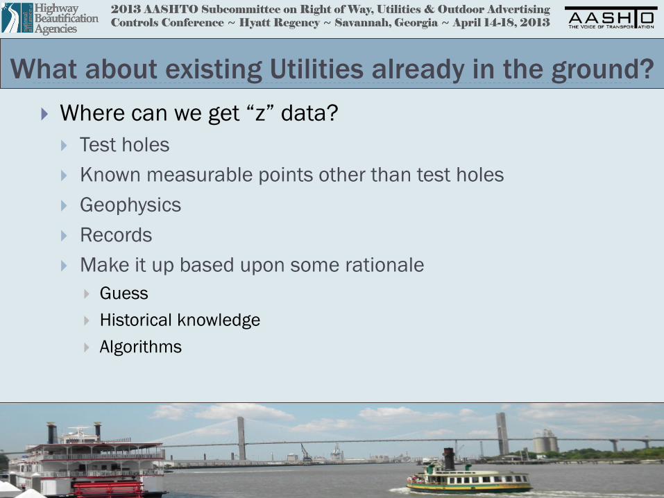
What about existing Utilities already in the ground?
Where can we get “z” data?
Test holes
Known measurable points other than test holes
Geophysics
Records
Make it up based upon some rationale
Guess
Historical knowledge
Algorithms

2013 AASHTO Subcommittee on Right of Way, Utilities & Outdoor Advertising Controls Conference ~ Hyatt Regency ~ Savannah, Georgia ~ April 14-18, 2013
Where can you get accurate data other than test holes?
• Enter Basements
• Know relationship between
basement ceiling and outside
ground
• Measure pipes / cables coming in
wall to known reference
} measured depth
Only gives a single depth point that’s valid

2013 AASHTO Subcommittee on Right of Way, Utilities & Outdoor Advertising Controls Conference ~ Hyatt Regency ~ Savannah, Georgia ~ April 14-18, 2013
Where can you get accurate data other than test holes?
} Top of valve,
Not top of pipe
Filled with dirt {
Measure down at valves
Sources of error: depth not elevation, Are you on the pipe?

2013 AASHTO Subcommittee on Right of Way, Utilities & Outdoor Advertising Controls Conference ~ Hyatt Regency ~ Savannah, Georgia ~ April 14-18, 2013
Where can you get accurate data other than test holes?
Measure Down In Vaults

2013 AASHTO Subcommittee on Right of Way, Utilities & Outdoor Advertising Controls Conference ~ Hyatt Regency ~ Savannah, Georgia ~ April 14-18, 2013
All these data can be accurate, but they are only Single Points
Test Hole Valve
Basement
Wall
Vault Valve Test Hole

2013 AASHTO Subcommittee on Right of Way, Utilities & Outdoor Advertising Controls Conference ~ Hyatt Regency ~ Savannah, Georgia ~ April 14-18, 2013
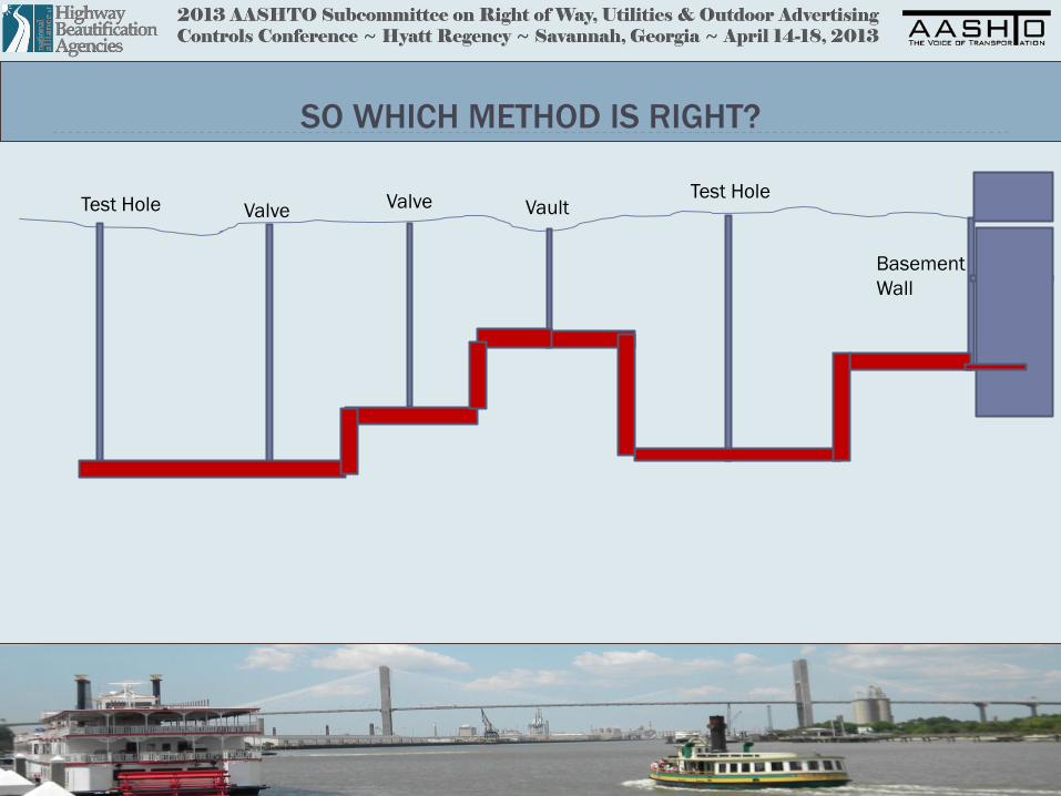
How do we Connect The Points?
Test Hole Valve
Basement
Wall
Vault Valve Test Hole
INTERPOLATION METHODS Does this look like any kind of piping system you’ve ever seen?
2013 AASHTO Subcommittee on Right of Way, Utilities & Outdoor Advertising Controls Conference ~ Hyatt Regency ~ Savannah, Georgia ~ April 14-18, 2013
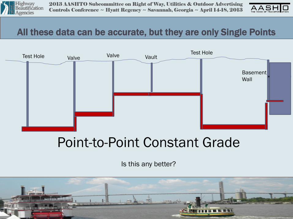
All these data can be accurate, but they are only Single Points
Test Hole Valve
Basement
Wall
Vault Valve Test Hole
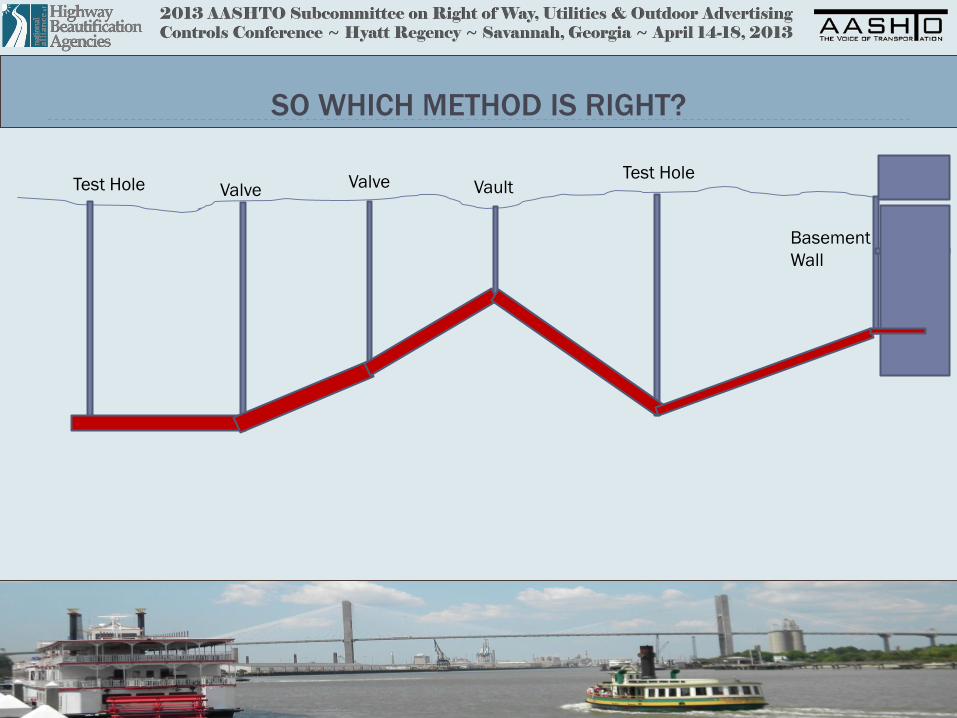
Point-to-Point Constant Grade
Is this any better?

2013 AASHTO Subcommittee on Right of Way, Utilities & Outdoor Advertising Controls Conference ~ Hyatt Regency ~ Savannah, Georgia ~ April 14-18, 2013
All these data can be accurate, but they are only Single Points
Test Hole Valve
Basement
Wall
Vault Valve Test Hole
The 50% Constant Grade Method

2013 AASHTO Subcommittee on Right of Way, Utilities & Outdoor Advertising Controls Conference ~ Hyatt Regency ~ Savannah, Georgia ~ April 14-18, 2013
SO WHICH METHOD IS RIGHT?
2013 AASHTO Subcommittee on Right of Way, Utilities & Outdoor Advertising Controls Conference ~ Hyatt Regency ~ Savannah, Georgia ~ April 14-18, 2013
SO WHICH METHOD IS RIGHT?
Test Hole Valve
Basement
Wall
Vault Valve Test Hole

2013 AASHTO Subcommittee on Right of Way, Utilities & Outdoor Advertising Controls Conference ~ Hyatt Regency ~ Savannah, Georgia ~ April 14-18, 2013
SO WHICH METHOD IS RIGHT?
Test Hole Valve
Basement
Wall
Vault Valve Test Hole
2013 AASHTO Subcommittee on Right of Way, Utilities & Outdoor Advertising Controls Conference ~ Hyatt Regency ~ Savannah, Georgia ~ April 14-18, 2013
SO WHICH METHOD IS RIGHT?
Test Hole Valve
Basement
Wall
Vault Valve Test Hole

2013 AASHTO Subcommittee on Right of Way, Utilities & Outdoor Advertising Controls Conference ~ Hyatt Regency ~ Savannah, Georgia ~ April 14-18, 2013
So it’s Obvious That we need to Fill in the Gaps
with Something Better Than Existing CADD Program Solutions
Geophysics Offers a Solution
Cannot put an accuracy to any “z” values
What is the “z” data density? (cost and time and process)
What are the Q.A. procedures to check the values?
How do we depict?

2013 AASHTO Subcommittee on Right of Way, Utilities & Outdoor Advertising Controls Conference ~ Hyatt Regency ~ Savannah, Georgia ~ April 14-18, 2013
All Geophysics are not created equal
GPR
Sondes
Pipe & Cable Locators
Relative “Accuracy”
INCREASES
Relative
Ability to Image Utilities
INCREASES

2013 AASHTO Subcommittee on Right of Way, Utilities & Outdoor Advertising Controls Conference ~ Hyatt Regency ~ Savannah, Georgia ~ April 14-18, 2013
Relative “Accuracies” / Relative Effectiveness
GPR
Sondes
Pipe & Cable Locators
Relative “Accuracy”
INCREASES
Relative
Ability to Image Utilities
INCREASES
+/- ½ Foot : < 40% in good soils
+/- 1 Foot : < 1 %
Too variable to say: 80%

2013 AASHTO Subcommittee on Right of Way, Utilities & Outdoor Advertising Controls Conference ~ Hyatt Regency ~ Savannah, Georgia ~ April 14-18, 2013
Depth Records
DANGER
WILL ROBINSON,
DANGER

2013 AASHTO Subcommittee on Right of Way, Utilities & Outdoor Advertising Controls Conference ~ Hyatt Regency ~ Savannah, Georgia ~ April 14-18, 2013
Without Method Differentiation, the Whole Purpose of ASCE 38 is
Moot. Decreased Ability to Manage Risk
Image incorporates main street data point cloud, with a combination
Of various undifferentiated methods of populating the “z”
RECORDS / TEST HOLES / GEOPHYSICS / FILL IN THE GAPS

2013 AASHTO Subcommittee on Right of Way, Utilities & Outdoor Advertising Controls Conference ~ Hyatt Regency ~ Savannah, Georgia ~ April 14-18, 2013
Individual Utility Profiles are easy to Differentiate

2013 AASHTO Subcommittee on Right of Way, Utilities & Outdoor Advertising Controls Conference ~ Hyatt Regency ~ Savannah, Georgia ~ April 14-18, 2013
3-D Models Less So
Error of “z” compounded with error of ground topo
elevation
How do you depict various types of geophysics
methods, test holes, measure-downs, and records in
this 3-D view?

2013 AASHTO Subcommittee on Right of Way, Utilities & Outdoor Advertising Controls Conference ~ Hyatt Regency ~ Savannah, Georgia ~ April 14-18, 2013
For a 3-D map “as good as it gets…..”
Perform all possible measure-downs
Document sources of error and correction (dirt in valve, top of
valve, basement/ground interface)
Use all possible appropriate geophysics
Training of technicians in how to recognize “good versus bad”
depth readings absolutely critical
Need robust Q.A. program to check values in field and office
Need to differentiate geophysical methods for every single line,
point, or polygon
Reliance on automated CAD algorithms dangerous
Need adequate ground-truthing / QLA data for correlations