Using ArcGIS Collector for Infrared Scanning and Tracking · Using ArcGIS Collector for Infrared...
39
Using ArcGIS Collector for Infrared Scanning and Tracking Andy Schmidt Project Manager, GIS Great River Energy
-
Upload
truongminh -
Category
Documents
-
view
239 -
download
2
Transcript of Using ArcGIS Collector for Infrared Scanning and Tracking · Using ArcGIS Collector for Infrared...

Using ArcGIS Collector for Infrared Scanning and Tracking
Andy Schmidt
Project Manager, GIS
Great River Energy

ArcGIS Collector for IR Scanning and Tracking
Presentation agenda
• History of the Infrared (IR) Project
• How we are using ArcGIS collector
• Setup options
• Reporting
• Next steps
• Conclusions

History
• Started in 2005
– IR sites list
• Reported out of our asset management system
• Resulted in a 3” binder full of printed information
• Scan details were recorded by hand in this book
– IR maps
• Initially used a large printed transmission wall map for tracking
• Highlight the substations and switch location when complete
• Used GRE printed map book for navigation

History, continued
• IR reports
• IR camera’s reporting software
– Only for equipment that was running hotter than the acceptable range
– Reports were printed and routed to transmission maintenance
• Sites completed
– The IR sites list was hand reconciled with open preventative maintenance work orders
– Created missed locations paper reports for follow-up

History, continued
• 2009
– Investigated using ESRI ArcPad
• Too small of a screen
• Navigation not quite there
• Not easy to update data – Dump of many GIS layers and sync back and forth
History, continued
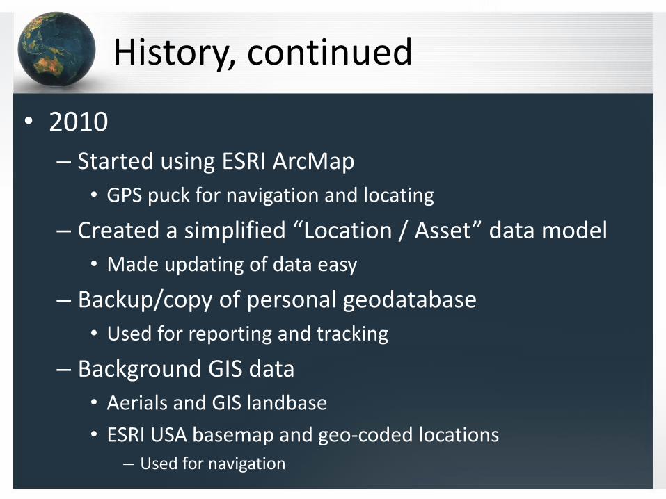
• 2010
– Started using ESRI ArcMap
• GPS puck for navigation and locating
– Created a simplified “Location / Asset” data model
• Made updating of data easy
– Backup/copy of personal geodatabase
• Used for reporting and tracking
– Background GIS data
• Aerials and GIS landbase
• ESRI USA basemap and geo-coded locations– Used for navigation
History, continued
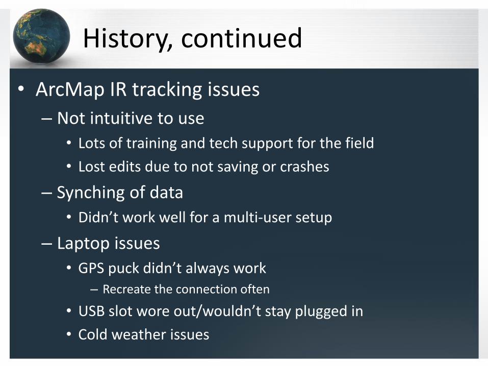
• ArcMap IR tracking issues
– Not intuitive to use
• Lots of training and tech support for the field
• Lost edits due to not saving or crashes
– Synching of data
• Didn’t work well for a multi-user setup
– Laptop issues
• GPS puck didn’t always work– Recreate the connection often
• USB slot wore out/wouldn’t stay plugged in
• Cold weather issues

History, continued
– IR points were not always updated at the time of the scan
• GIS staff still performed updates on scans completed
• Date time stamp could be a couple months off
– Reports
• Preventative maintenance closeouts still a manual process…

Current IR Process
• 2013
– Started Using ArcGIS collector
– Using on iPads with mobile data plans
– Data resides within an enterprise SDE database
• Continue utilizing simplified “Location / Asset” dataset
• IR data updates are captured real time
– Easy setup
• Didn’t have to load landbase data and aerial photography– Utilized ESRI basemap services
• Consumed existing standard GIS services from GRE

Current IR Process - Data Model
• Initial Generation of IR Sites
– All site layers in GIS were merged into an IR location point
• Includes all substations, generation, switch sites, etc.
• All contain a unique identifier of “Location” and a “X,Y” position
• Geoprocessing tool of “Append” to create
– All asset IR points were created based on the X,Y coordinate of the IR Location point
• Joined asset points table to IR site points to generate point table

Current IR Process
• Yearly start of project
– Preventative maintenance (PM) work order generation
• Export of IR locations and assets from asset management
• Excel file
– GIS verification
• Verify all IR locations match new PM location report– New sites get added
– No sites get removed (just definition queried out)
• Verify all IR points match PM asset report– New assets are added, none are removed
– Migrate last years IR scan data

IR Locations Table

IR Point Table

IR Hosted Services
• Infrared Field Edits
– Feature access for query and update only
• Locations
• IR Points – Definition query to layers of transformers, breakers, switches, …
• Mapping access layers (view only-reference)
– GRE and foreign transmission layers
– Service areas
– Cooperative areas

Setting up the ArcMap Project
• Set attributes to display – field on/off
• Set desired attributes to read only
• Break IR points into types using definition queries
– Simplifies finding the IR point

Creating the service
Create services in ArcMap
• Share as a service
• Set the parameters
• Publish
Service properties• Feature access
• Only query and update
• No insert or delete

ArcGIS Online

Create the Map
• Add layers from server

Create Pop-up’s for Layers

Setup Search Queries
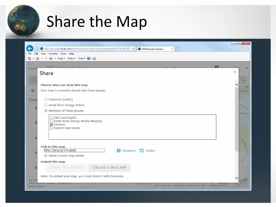
Share the Map

Collector Notes
• Runs on mobile devices
– Tablets, phones, Windows 10 computers/tablets
– Apple, Android, Windows 10
• Requires
– One layer must be a Feature access type
• Editable
– A named user in a ArcGIS organizational account
• Free app
• Install from the app store’s

Collector
• Log in to ArcGIS collector
• Open up the GRE infrared collector map
• Pan / zoom to the area you intend to do work in
• Search for an IR site
– Use the navigation to get to the desired site
• Blue plus sign symbols = remaining sites– Typically do northern system in the winter
– Metro system in the summer
– Southern system in the fall
– Generators when active

Collecting IR Data
• Perform IR Scans
– If no issues found only update the IR site attributes
• Status Complete - No Issues
• IR Date choose today's date
• IR Site Condition – log the current weather at the location
• IR Site Comments – log any notes about the site
– If issues are found
• Do above but mark as Status Complete-Issues
• Find IR point of device with elevated reading– IR Priority range: 1- Critical 70° over to 4- low 20° over ambient
– IR Comment – Information on the probable cause
– IR Photo – photo number for the report

ArcGIS Collector Demo

Server geoprocessing
• Used to attribute IR points data based on the IR location’s attributes
– Assets that have no issues
– Saves time by not having to fill information on each piece of equipment
– Necessary for reporting and status tracking

IR Tracking View

IR Reports
Location of Fault - Top Phase Bolted Pad

GIS Reporting

Future Tasks
• Synch complete in asset management
– Close PM work order if site is scanned and no issues found
– Auto generate of maintenance WO’s of sites with issues
• Equipment replacement recommendation
– Analyze six years worth of IR data
– Trend analysis
– Aging infrastructure

IR Past Status 2010

IR Past Status 2011

IR Past Status 2012
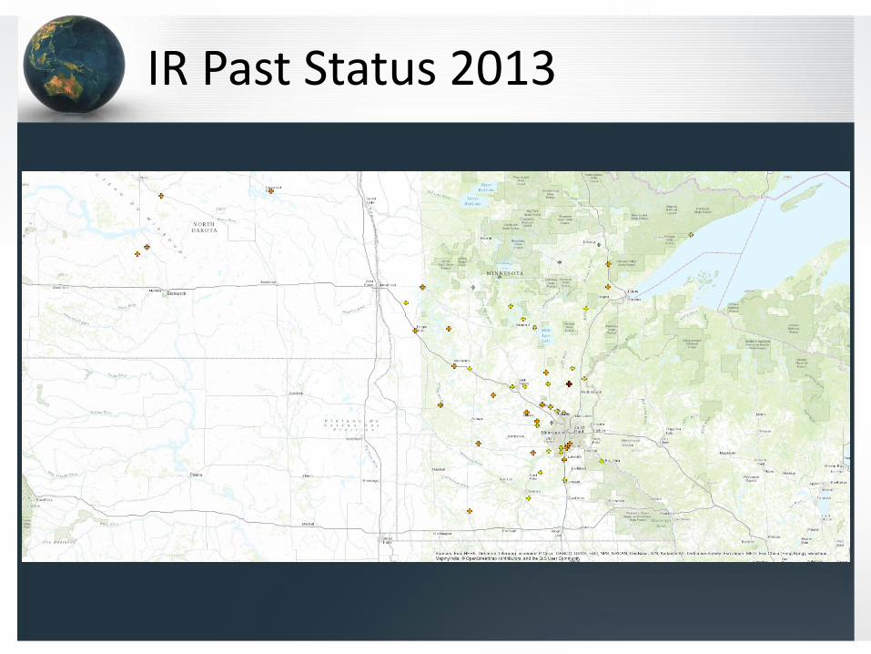
IR Past Status 2013

IR Past Status 2014

IR Past Status 2015

IR Past Status All Years

Conclusions
• Application is easy to use
• Setup and deployment is fast <8 hours per year
• Keep field data updating to a minimum
• GIS tech maintenance and updates is minimal
• Data is always current for multiple users with no overlap
• Other benefits
– Project tracking, mission planning, optimized travel between sites, verification of work, no paper produced, history of IR scan results, site access notes