
USE OF REMOTE SENSING FOR LCLU MONITORING IN...
46
USE OF REMOTE SENSING FOR LCLU MONITORING IN TURKEY Prof.Dr. Derya Maktav Istanbul Technical University Geomatics Engineering Department http://web.itu.edu.tr/maktavd [email protected] WORKSHOP SEERIN/ April 17, 2012 Sofia, Bulgaria 1 ~15 minutes
-
Upload
nguyenquynh -
Category
Documents
-
view
217 -
download
1
Transcript of USE OF REMOTE SENSING FOR LCLU MONITORING IN...

USE OF REMOTE SENSING FOR LCLU MONITORING IN TURKEY
Prof.Dr. Derya MaktavIstanbul Technical University
Geomatics Engineering Department
http://web.itu.edu.tr/[email protected]
WORKSHOP SEERIN/ April 17, 2012 Sofia, Bulgaria 1
~15 minutes
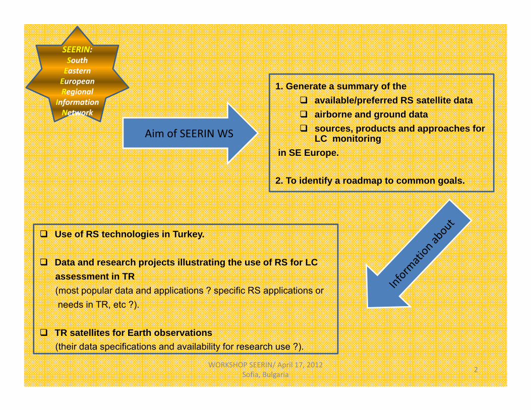
Aim of SEERIN WS
WORKSHOP SEERIN/ April 17, 2012 Sofia, Bulgaria 2
SEERIN: South Eastern European Regional
Information Network
1. Generate a summary of the available/preferred RS satellite data airborne and ground data sources, products and approaches for
LC monitoringin SE Europe.
2. To identify a roadmap to common goals.
Use of RS technologies in Turkey.
Data and research projects illustrating the use of RS for LCassessment in TR(most popular data and applications ? specific RS applications orneeds in TR, etc ?).
TR satellites for Earth observations(their data specifications and availability for research use ?).

Official web sites
Brochures (flyers)
Papers & articles (panels, symposia, conferences, journal)
Books
Personal contacts (phone calls, e‐mails, visits) * Governmental institutions* Universities * Private companies
Personal experiencesWORKSHOP SEERIN/ April 17, 2012 Sofia, Bulgaria 3
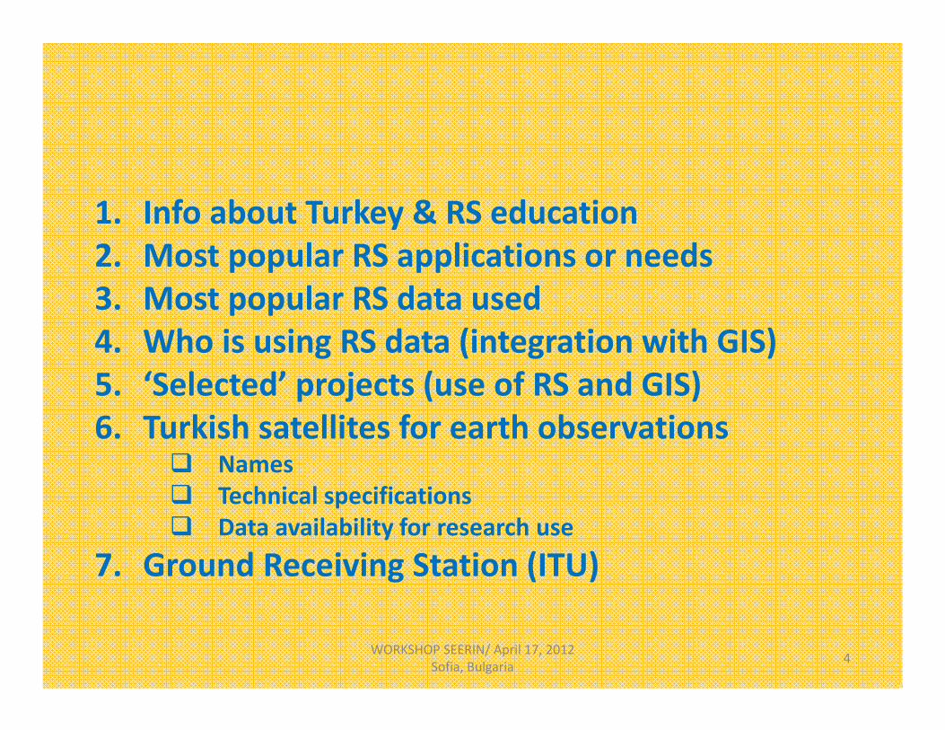
1. Info about Turkey & RS education2. Most popular RS applications or needs3. Most popular RS data used4. Who is using RS data (integration with GIS)5. ‘Selected’ projects (use of RS and GIS)6. Turkish satellites for earth observations
Names Technical specifications Data availability for research use
7. Ground Receiving Station (ITU)
WORKSHOP SEERIN/ April 17, 2012 Sofia, Bulgaria 4

1. Information about Turkey & RS education
WORKSHOP SEERIN/ April 17, 2012 Sofia, Bulgaria 5

WORKSHOP SEERIN/ April 17, 2012 Sofia, Bulgaria 6
A bridge betw. 2 continents. 815,000 km2 (incl. lakes and rivers). 81 cities. Population: 73.722.988 (Dec. 31, 2010).
• 76,3% of the total population (56.222.356 persons) lives in the province and district centers.
• 23,7% lives in towns and villages (17.500.632 persons).
Population in the province and district centers: highest in Istanbul (99%), lowest in Ardahan (32%) .
Population:• Istanbul: 18,0% (13.255.685). • Ankara: 6,5% (4.771.716).• İzmir: 5,4% (3.948.848).• Bursa: 3,5% (2.605.495).• Adana: 2,8% (2.085.225).• ~ BULGARIA: 8.000.000
WORKSHOP SEERIN/ April 17, 2012 Sofia, Bulgaria 7
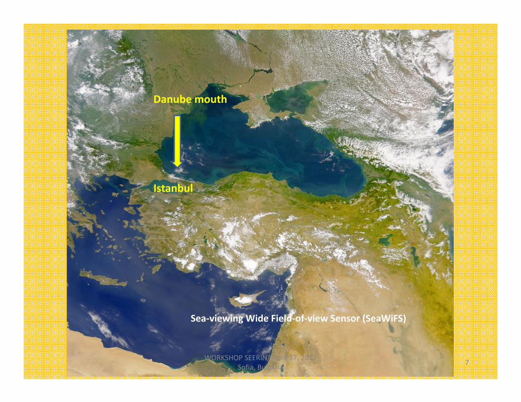
Sea‐viewing Wide Field‐of‐view Sensor (SeaWiFS)
Danube mouth
Istanbul

1. Remote sensing education in Turkey
Total univ.: 167 123 state univ.
• 5 tech. univ.• 2 institutes of technology• 1 fine arts univ.).
44 private foundation univ.
4 military academies 1 police academy.
►RS Education ?
WORKSHOP SEERIN/ April 17, 2012 Sofia, Bulgaria 8
RS in universities (15):Univ. Depts. (Geomatics Engineering)
Istanbul Tech Univ.,Yıldız Technical Univ., Okan, Afyon Kocatepe, Aksaray, Gümüşhane,KTÜ, Zonguldak Karaelmas, Kayseri Erciyes, Kocaeli, Konya Selçuk, Ondokuz Mayıs, Sivas Cumhuriyet, Gebze Yüksek Teknoloji Enst., (Graduate), Hacettepe (Graduate)
Universities specialized in certain topical areas (e.g. technology or business): SURVEYING, 2 years: (47)• Tapu Kadastro MYO: 1• Harita Kadastro MYO: 46
Career schools (Meslek lisesi): (56)Reference: The Council of Higher Education, Ministry of National Education Turkey.

2. Most popular RS applications or needs in TR
WORKSHOP SEERIN/ April 17, 2012 Sofia, Bulgaria 9

Illegal housing mainly in big cities (Istanbul, Ankara, Izmir, Antalya). Urban transformations. Disaster monitoring (flood, earthquake, forest fires). Agriculture: crop estimation. Surface archaeology, cultural heritage monitoring.
WORKSHOP SEERIN/ April 17, 2012 Sofia, Bulgaria 10
3. Most popular RS data used in TR
WORKSHOP SEERIN/ April 17, 2012 Sofia, Bulgaria 11

HR: IKONOS, QB, SPOT, GeoEyeMS: Landsat, SPOT Radar (ERS, RADARSAT) Aerial photographs‐Orthophotos Terrestrial laser scanning (TLS) LIDAR (new)
WORKSHOP SEERIN/ April 17, 2012 Sofia, Bulgaria 12Gölyazı Church
IKONOS‐İzmir

4. Who is using RS data + GIS ?
Governmental institutions• Min. of Environment and Urbanization• Min. of Forest and Water Affairs
– General Directorate of Forestry– General Directorate of State Meteorological Affairs
• Municipalities (Istanbul Metropolitan Municipality): İBB• General Directorate of Mineral Research and Exploration (MTA)
Military: General Command of Mapping (HGK)Private companiesUniversities: Research projectsWORKSHOP SEERIN/ April 17, 2012
Sofia, Bulgaria 13
5. ‘Selected’ Projects[use of RS (aerial photos, sat. imageries) and GIS]
WORKSHOP SEERIN/ April 17, 2012 Sofia, Bulgaria 14

Ministry of Forest and Water Affairs‐General Directory of Forestry
Activities:
– Sustainable forest management– Climate change and bioenergy– Biodiversity– Forest fires and preventing and combating– Forest and water– Protection of forest– Non wood products– Rectreational services– Forest info sytems
WORKSHOP SEERIN/ April 17, 2012 Sofia, Bulgaria 15
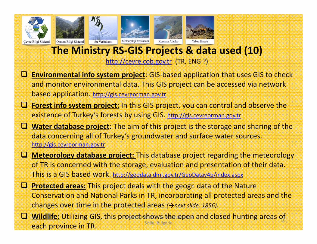
The Ministry RS‐GIS Projects & data used (10)http://cevre.cob.gov.tr (TR, ENG ?)
Environmental info system project: GIS‐based application that uses GIS to check and monitor environmental data. This GIS project can be accessed via network based application. http://gis.cevreorman.gov.tr
Forest info system project: In this GIS project, you can control and observe the existence of Turkey’s forests by using GIS. http://gis.cevreorman.gov.tr
Water database project: The aim of this project is the storage and sharing of the data concerning all of Turkey’s groundwater and surface water sources.http://gis.cevreorman.gov.tr
Meteorology database project: This database project regarding the meteorologyof TR is concerned with the storage, evaluation and presentation of their data. This is a GIS based work. http://geodata.dmi.gov.tr/GeoDatav4p/index.aspx
Protected areas: This project deals with the geogr. data of the Nature Conservation and National Parks in TR, incorporating all protected areas and the changes over time in the protected areas (→next slide: 1856).
Wildlife: Utilizing GIS, this project shows the open and closed hunting areas of each province in TR.
WORKSHOP SEERIN/ April 17, 2012 Sofia, Bulgaria 16

Afforestation database project: The collection and evaluation of the data in GIS regarding the info of the revival of non‐forested land from scratch in TR.
Environmental Impact Assessment (EIA): GIS project that aims to store and share all kinds of environment‐related data to better understand an area.
Environmental Protection (ÖÇK): The Min. carried out this GIS project within the scope of TR enabling us to observe, evaluate and control natural, historical and cultural values, sustainability and biodiversity preservation, and the creation of a healthy and clean environment.
Turkish Environmental Information Exchange Network (TEIEN): A single electronic network that would allow for easy access and sharing of env. data betw. institutions dealing with env. issues. http://www.teien.org.tr/sp/main_page.html
CORINE (Coordination of Info on the Environment): a European programme initiated in 1985 by the Eur. Commis., aimed at gathering info relating to the environment on certain priority topics for the EU (air, water, soil, LC, coastal erosion, etc.). Since 1994, the Eur. Environment Agency (EEA) integrated CORINE in its work programme. EEA is responsible for providing objective, timely and targeted info on Europe's environment.
INSPIRE project (Infrastructure for Spatial Info in the European Community): aims to create a EU spatial data infrastructure. This will enable the sharing of environmental spatial info among public sector organisations and better facilitate public access to spatial info across Europe. There are some applications such as collecting geogr.data and improve it via satellite imagery.
WORKSHOP SEERIN/ April 17, 2012 Sofia, Bulgaria 17

GIS templates of Ministry
TRANSPORTATION:This data set shows TR’s Road Transport
and contains info about coastal systems. There is also
an option to display the airports and railways on the
map.
WATER: TR’s Water data set contains a layer of info showing the
water and water supply configurations. In the water data set, the water configuration and
water resources aside from the State Hydraulics Works can be found in
another layer.
FOREST: The forest data set for the Turkish General Direct. of Forestry in
addition to the Administrative Structuring of the use of forest roadsand forests can be accessed through the application on the info map.
AFFORESTATION: The data set containing the info on TR’s
Afforestation Mobilization and Nursery layer in the map consists of the work of the AGM, more detailed info can be found by
viewing the map.
ENVIRONMENT: This data set shows TR’s environmental facilities and industrial units including the Solid Waste Units and Industrial
Buildings, more detailed info can be found by viewing the map on related
services.
WATERSHED PROTECTION: In this data set of TR’s Watershed Protection contains treatment
facilities and residential centers. In the map view, you can access the data layer of the various treatment plants alongside Solid Waste Storage Areas and located in the District
Union Boundaries.
METEOROLOGY: The data set for the Ministry of Meteorological in TR, uses a different theme in GIS. This data set displays the Weather Stations on a layer in the map, the
imaging offers a variety of climatological values.
ENVIRONMENTAL MONITORING: The data set for TR’s Environment Observation Stations shows the Air Pollution and swimming water
measurement stations. In addition, there is detailed info on EIE, DMI and State Hydraulic Works institutions, which can
be accessed via the map
PROTECTED AREAS: The data set for TR’s Preserved Areas shows places aside from the preserved
areas such as the Wildlife Development Areas, Protected Areas and Recreation Areas are available in the layers. The Nat.
Parks and Nature Parks are located in the layers of this data set as well.
WILDLIFE: This data set contains layers of TR’s Wildlife. Hunting and private hunting grounds and can be viewed in the Restricted Areas on the map. More info about these
layers of the Ministry of Wildlife can be reached through the use of GIS.
OCEANOGRAPHY: The oceanographic data set for TR
provides info about the depth of water in the world on the map. In
addition, the detailed data about TR’s oceanography is accessible. Depths betw 7000‐2000 m. are shown in the
oceanography layers.
WORKSHOP SEERIN/ April 17, 2012 Sofia, Bulgaria 18

Data used
LANDSAT ~120.000 aerial photographs
~78.000 (1:25000) top maps
~260 (1:50000) top maps
WORKSHOP SEERIN/ April 17, 2012 Sofia, Bulgaria 19
~2500 (1:100000) top maps SPOT
Uploaded into the database via internet (for a quicker access).

Photo archiveAerial photos, maps, satellite
imageries archive monitoring system (under construction)
Photogrammetry Archive Monitoring System: • Aerial photographs and 1:25000, 1:50000 and 1:100000 maps
are transferred to the database for a more quick access.
• Photogrammetry Archive Monitoring System: hava fotoğraflarına, haritalara, yer ölçümlerine ve matematik istatistiksel yöntemlere olan ihtiyaçları karşılamak ve bu çalışmalara altlık oluşturmak için, hava fotoğrafları ve 1/25.000, 1/50.000 ve 1/100.000 ölçekli haritalar internet üzerinden daha hızlı erişim hizmeti için veri tabanına aktarılmıştır.
http://orbisgenel.ogm.gov.tr/WORKSHOP SEERIN/ April 17, 2012
Sofia, Bulgaria 20

General Directorate of State Meteorological affairs
• Weather forecast (Meteosat, Eumetsat)
WORKSHOP SEERIN/ April 17, 2012 Sofia, Bulgaria 21

►5‐days Weather Forecast of Turkey
WORKSHOP SEERIN/ April 17, 2012 Sofia, Bulgaria 22
► Snow heights

► Surface map
WORKSHOP SEERIN/ April 17, 2012 Sofia, Bulgaria 23
7 SELECTED PROJECTS BY İBBWHERE RS AND GIS WERE USED.
WORKSHOP SEERIN/ April 17, 2012 Sofia, Bulgaria 24
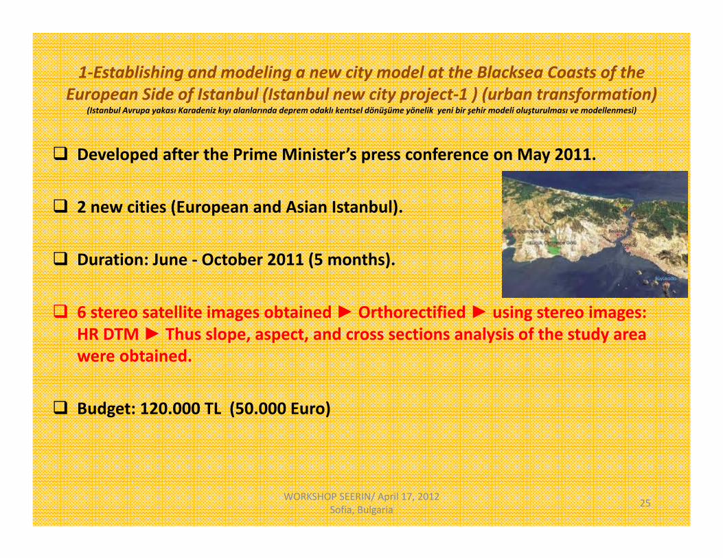
1‐Establishing and modeling a new city model at the Blacksea Coasts of the European Side of Istanbul (Istanbul new city project‐1 ) (urban transformation)
(Istanbul Avrupa yakası Karadeniz kıyı alanlarında deprem odaklı kentsel dönüşüme yönelik yeni bir şehir modeli oluşturulması ve modellenmesi)
Developed after the Prime Minister’s press conference on May 2011.
2 new cities (European and Asian Istanbul).
Duration: June ‐ October 2011 (5 months).
6 stereo satellite images obtained ► Orthorectified ► using stereo images: HR DTM ► Thus slope, aspect, and cross sections analysis of the study area were obtained.
Budget: 120.000 TL (50.000 Euro)
WORKSHOP SEERIN/ April 17, 2012 Sofia, Bulgaria 25

2‐ Urban Design Project aiming to create an econometric model as per Historical Peninsula (Fatih and Eminönü Districts' Sites) in scale of 1:5000 and 1:1000
Goals
To protect the identity of the Historical Peninsula in Istanbul. To enhance the continuity of the existing cultural heritage. To find solutions that prevent historical buildings to break down and to preserve their original identity. To point out the need for rehabilitation, restoration etc. to improve the identity of the natural and cultural
elements. To enable preservation and harmony by picking the sides that are incompatible with the original texture
Duration: 2006 –2008. Budget: 45.000.000 TL (20 million Euro). HR sat images (IKONOS 1m pan‐sharpaned)were used for analysis of the project area, detecting the
objects used in the analysis, updating the base maps. Combining roof models from stereo aerial photos and laser scanning data of building fronts (for
restoration) = 3D urban models obtained.
Bina cephelerinin restorasyon amaçlı lazer taramalarından gelecek olan cephe verilerinin, stereo hava fotoğrafları teknolojisi ileçıkarılacak çatı modelleri ile birleştirilmeleri sonucu 3D bir kent modeli oluşturulmuştur.
WORKSHOP SEERIN/ April 17, 2012 Sofia, Bulgaria 26

3‐Earthquake Based Urban Transformation Project (Zeytinburnu Pilot Project)4‐Fatih Earthquake Based Transformation Project5‐Küçükçekmece Urban Renewal Project (Kentsel Yenileme Projesi)
• Duration: Sept 2005‐Dec. 2010
WORKSHOP SEERIN/ April 17, 2012 Sofia, Bulgaria 27
FATİH
K.Çekmece
ZEYTİNBURNU
To protect and improve the cultural, historical and natural heritage of the districts Fatih, Zeytinburnu, K.Çekmece.
To provide durable, safe and livable urban spaces.
To improve the social and economical status throughout the project time line.
To obtain LU maps: middle & HR sat. data were used: LANDSAT (30 m), IKONOS (1m).
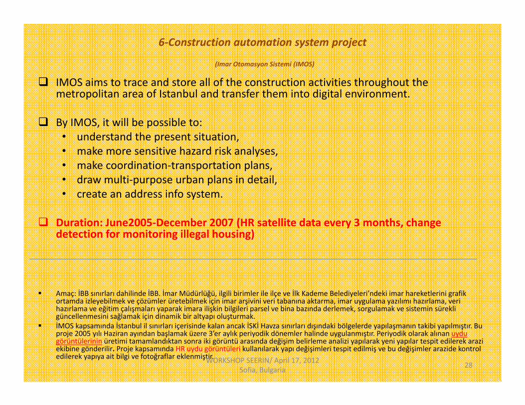
6‐Construction automation system project
(Imar Otomasyon Sistemi (IMOS)
IMOS aims to trace and store all of the construction activities throughout the metropolitan area of Istanbul and transfer them into digital environment.
By IMOS, it will be possible to:• understand the present situation,• make more sensitive hazard risk analyses,• make coordination‐transportation plans, • draw multi‐purpose urban plans in detail,• create an address info system.
Duration: June2005‐December 2007 (HR satellite data every 3 months, change detection for monitoring illegal housing)
Amaç: İBB sınırları dahilinde İBB. İmar Müdürlüğü, ilgili birimler ile ilçe ve İlk Kademe Belediyeleri’ndeki imar hareketlerini grafik ortamda izleyebilmek ve çözümler üretebilmek için imar arşivini veri tabanına aktarma, imar uygulama yazılımı hazırlama, veri hazırlama ve eğitim çalışmaları yaparak imara ilişkin bilgileri parsel ve bina bazında derlemek, sorgulamak ve sistemin sürekli güncellenmesini sağlamak için dinamik bir altyapı oluşturmak.
İMOS kapsamında İstanbul il sınırları içerisinde kalan ancak İSKİ Havza sınırları dışındaki bölgelerde yapılaşmanın takibi yapılmıştır. Bu proje 2005 yılı Haziran ayından başlamak üzere 3’er aylık periyodik dönemler halinde uygulanmıştır. Periyodik olarak alınan uydu görüntülerinin üretimi tamamlandıktan sonra iki görüntü arasında değişim belirleme analizi yapılarak yeni yapılar tespit edilerek arazi ekibine gönderilir. Proje kapsamında HR uydu görüntüleri kullanılarak yapı değişimleri tespit edilmiş ve bu değişimler arazide kontrol edilerek yapıya ait bilgi ve fotoğraflar eklenmiştir. WORKSHOP SEERIN/ April 17, 2012
Sofia, Bulgaria 28

7‐Istanbul Metropolitan Development Plan
(İstanbul İli Çevre Düzeni Planı’nın Hazırlanması)
Goal: A new 1:100,000 scale Istanbul Environmental Plan (use of RS and GIS).
Duration: 2005‐2007.
IKONOS (1m Pan‐sharpaned) image mosaicking ► base maps....
Pixel based classification (1990,1995,2000,2005 LANDSAT data)► LU maps ►city growth and development direction obtained.
WORKSHOP SEERIN/ April 17, 2012 Sofia, Bulgaria 29

6. Turkish sats for earth observations(names, tech. specifications, availability for research use) ?
RASATBILSAT
GÖKTÜRK
WORKSHOP SEERIN/ April 17, 2012 Sofia, Bulgaria 30

RASAT: Technical specifications First RS satellite designed and built in TR (2. RS: BİLSAT !) Developed by TÜBITAK. Has been put into operation on 17 August 2011. Weight: 93 kg. Orbit: 689 km circular, sun synchronous. Orbital cycle: 98.8 min. Spatial res: Pan‐7.5 m, ms‐15 m. Spectral res (μm)
0.42 – 0.73 (Pan)Band 1: 0.42 – 0.55 (Blue)Band 2: 0.55 – 0.58 (Green)Band 3: 0.58 – 0.73 (Red)
Rad. res: 8 bit. Temp. res: 4 days. Swath width: 30 km. Data (2011 and future) available for research projects (free...) http://www.uzay.tubitak.gov.tr/tubitakUzay/en/projects/spaceApplications.php
#rasat
WORKSHOP SEERIN/ April 17, 2012 Sofia, Bulgaria 31TÜBİTAK: the Scientific and Technological Research Council of Turkey

RASAT image if IzmirTÜBITAK, RASAT Image Gallery
WORKSHOP SEERIN/ April 17, 2012 Sofia, Bulgaria 32

RASAT image applicationsMAPPING
•Mapping and updating of 1:25.000 scaled maps•DEM and orthophoto generation• LU mapping• Land resources cadastre
ENVIRONMENT• Identification of deforestration/reforestation areas•Change detection of coastlines•Oil spill detection and pollution mapping
DISASTER MONITORING•Forest fire monitoring and burnt area mapping•Flood mapping and forecasting•Landslide area mapping•Building destruction and damage assessment after earthquake•Making up‐to‐date thematic maps for disaster management
URBAN AND REGIONAL PLANNING
•Monitoring of urban development•Detection of illegal settlement sites• 3D simulation
WORKSHOP SEERIN/ April 17, 2012 Sofia, Bulgaria 33

BILSAT
WORKSHOP SEERIN/ April 17, 2012 Sofia, Bulgaria 34
Weight 129 kg
Orbit 686 km, circular, sun synchronous
This is a technology transfer project aimed at acquiring small satellite technologies. The project is conducted with Surrey Satellite Technology Ltd of Surrey Univ., UK.
Cameras 4 Bands MS: Ground resolution: 27,6 m Band 1: 0.45 ‐ 0.52 (blue) Band 2: 0.52 ‐ 0.60 (green) Band 3: 0.63 ‐ 0.69 (red)Band 4: 0.76 ‐ 0.90 (NIR)
B/W camera: 12.6 m. yer örnekleme mesafesi olan
TUBITAK SPACE 2003-2006 (Data available for research projects.)

BILSATBaghdat
23 Jan 2005
WORKSHOP SEERIN/ April 17, 2012 Sofia, Bulgaria 35

BILSATS.Africa
Oct 18 2003
WORKSHOP SEERIN/ April 17, 2012 Sofia, Bulgaria 36
The original contract was signed by Telespazio and the Undersecretariat forDefence Industries (SSM) in 2009
Satellite launch is planned for 2013. Satellite equipped with a HR optical sensor ???
GÖKTÜRK-1

GÖKTÜRK-1
– A satellite integration and test center to be built in Turkey.
– Entire ground segment will be build for the system to carry out in-orbit operationand data acquisition and processing.

GÖKTÜRK-1
Technical SpecificationsOrbit Sun-SynchronousOrbit Altitude Lover than 700kmRevisit Time Over Turkey Less than 2 DaysDry Weigh 1000 kgDesign Life 7 years
– Its observation payload includes a HR optical instrument an onboard X-band digital imaging system
to handle data compression, storage and downloading.

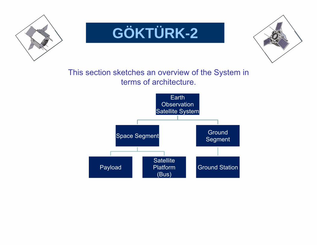
GÖKTÜRK-2
GÖKTÜRK-2 provides the TurkishDefence with a HR reconnaissanceand surveillance satellite system.
The contract was signed in 2007 by
Turkish Defense Ministry (MSB) Technological Research Council of
Turkey (TÜBİTAK) Turkish Aerospace Industries Inc. (TAI). Launch October 2012. Data availability ?.

GÖKTÜRK-2
GÖKTÜRK-2 Technical SpecificationsOrbit Sun-SynchronousOrbit Altitude ~700kmPeriod ~98 min. (14 times a day)Contact Time ~ 40 min. (day+night)Image Acquisition All Over The WorldReal Time Image RelaySatellite Mass < 409Image Storage Capacity >15 GbitResolution PAN 2,5m - MS 10m ????
GÖKTÜRK-2
This section sketches an overview of the System in terms of architecture.
Earth Observation
Satellite System
Space Segment
PayloadSatellite Platform
(Bus)
Ground Segment
Ground Station

GÖKTÜRK
References
Programme kickoff for Turkey’s Göktürk satellite system, supplied by Telespazio and Thales Alenia Space (www.thalesaleniaspace.com)
Göktürk satellite system (www.telespazio.com)
Göktürk: 2 2.5m Çözünürlüklü Görüntüleme Amaçlı Bilimsel Araştırma ve Teknoloji Uydusu Geliştirme Projesi (www.tai.com.tr)
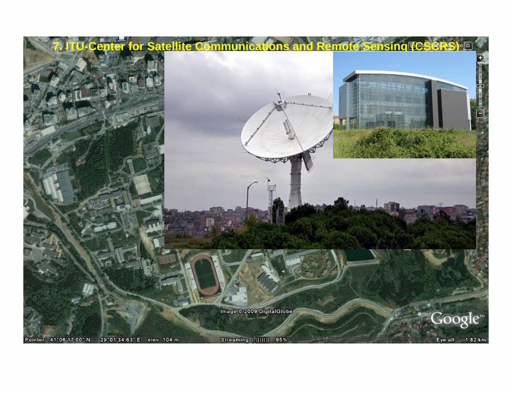
7. ITU-Center for Satellite Communications and Remote Sensing (CSCRS)

CSCRS
• It is a highly capable ground receiving station (GRS) unit.
• It is the first center established in Turkey to conduct application oriented projects in RS and sat communications technologies and serve national/international civil/military companies in their research, development, and educational activities.
• After successful design, assemble and test stages of the station through 1996-2000, CSCRS was established for operational working under the name ITU-SAGRES (SAtellite Ground REceiving Station) in 2000 as a wide range communications and RS integrated system. In the second half of 2003, it was restructured into ITU-CSCRS.
• It has the capabilities of acquiring images from RS satellites, processing data, and sending the products via satellite links to resident and foreign users. The station can receive images of the Earth's surface within a radius of 3000 km (Sweden-Sudan and England-Kazakhstan.
• In the center the data acquired from SPOT-2, SPOT-4, RADARSAT-1, ERS-2, NOAA-11, NOAA-14, METEOSAT is archived, formatted and processed with the state-of-the-art technology. These successful studies were certificated with Operational and Product Certificate by the Radarsat Inc., Canada in Nov. 2002.
• Availability of data: For research projects price discount.

• I hope all these information will be helpful for SEERIN formulation ► good luck..
Thanks for your attention.
WORKSHOP SEERIN/ April 17, 2012 Sofia, Bulgaria 46


![[REMOTE SENSING] 3-PM Remote Sensing](https://static.fdocuments.us/doc/165x107/61f2bbb282fa78206228d9e2/remote-sensing-3-pm-remote-sensing.jpg)


