US Highway 14: Owatonna to Dodge Center Road Safety Audit
29
US Highway 14: Owatonna to Dodge Center Road Safety Audit Review Technical Report September 26, 2013 Prepared By
Transcript of US Highway 14: Owatonna to Dodge Center Road Safety Audit

USHighway14:OwatonnatoDodgeCenterRoadSafetyAuditReviewTechnicalReportSeptember26, 2013
Prepared By

TableofContents1 Introduction .......................................................................................................................................... 1
1.1 Road Safety Audit Review (RSAR) Team ....................................................................................... 1
1.2 Road Safety Audit Review Process ................................................................................................ 1
1.3 Meeting With MnDOT District 6 ................................................................................................... 2
1.3.1 Future Plans – ....................................................................................................................... 2
1.3.2 Historical Perspective – ......................................................................................................... 2
1.3.3 Safety Issues and Goals – ...................................................................................................... 2
1.4 Meeting with USTH 14 Stakeholders ............................................................................................ 3
2 Background ........................................................................................................................................... 4
2.1 Corridor History ............................................................................................................................ 4
2.1.1 Recent Safety Improvement Projects ................................................................................... 4
2.2 Crash History ................................................................................................................................. 5
2.3 Intersection Analysis ................................................................................................................... 10
2.4 Behavioral Factors ....................................................................................................................... 11
2.5 Traffic Volumes ........................................................................................................................... 11
2.6 Commercial Vehicles ................................................................................................................... 12
3 Field Review Summary ........................................................................................................................ 13
3.1 Segments ..................................................................................................................................... 13
3.1.1 Roadway Geometry ............................................................................................................ 13
3.1.2 Field Access ......................................................................................................................... 13
3.1.3 Traffic Characteristics .......................................................................................................... 13
3.2 Intersections ............................................................................................................................... 13
3.2.1 Geometrics .......................................................................................................................... 13
3.2.2 Signing and Striping (Pavement Markings) ......................................................................... 13
4 Suggested Improvement Strategies .................................................................................................... 14
4.1 Corridor‐Wide Improvements ..................................................................................................... 14
4.1.1 Centerline Rumble Stripes .................................................................................................. 14
4.1.2 Four‐Foot Centerline Buffer Zone/Tube Delineators .......................................................... 14
4.1.3 Passing Zones ...................................................................................................................... 16
4.1.4 Corridor Redesign – Four‐Lane Freeway ............................................................................. 17
4.1.5 Winter Maintenance ........................................................................................................... 17
4.1.6 Speed Studies ...................................................................................................................... 18
4.1.7 Rail Crossings ....................................................................................................................... 18
4.2 Intersections ............................................................................................................................... 18

4.2.1 Turn/Bypass Lanes .............................................................................................................. 18
4.2.2 Signing and Striping Improvements .................................................................................... 19
4.3 Enforcement ............................................................................................................................... 20
4.3.1 Seatbelt Usage .................................................................................................................... 20
4.4 Commercial/Farm Vehicle Traffic ............................................................................................... 20
5 Segment‐Based Findings and Suggestions .......................................................................................... 20
5.1 Segment B – Transition Zone from Four‐Lane Divided to Two‐Lane Undivided (TH 218) to 1000’
East of 44th Avenue SE............................................................................................................................. 21
5.2 Segment C – 1000’ East of 44th Avenue SE to 0.5 Miles East of 64th Avenue SE ......................... 22
5.3 Segment D – 0.5Miles East of 64th Avenue SE to West End of Claremont .................................. 23
5.4 Segment E – West End of Claremont to East End of Claremont ................................................. 23
5.5 Segment F – East End of Claremont to USTH 14 Curve (0.5 miles east of CSAH 5 east
intersection) ............................................................................................................................................ 24
5.6 Segment G – USTH 14 Curve to Transition Zone from Two Lane Undivided to Four‐Lane Divided
South of TH 56......................................................................................................................................... 24
6 Summary ............................................................................................................................................. 25
Table of Figures
Figure 1 – Road Safety Audit Team ............................................................................................................... 1
Figure 2 ‐ USTH 14 ......................................................................................................................................... 4
Figure 3 ‐ Crash Rate and Severity Rate ........................................................................................................ 5
Figure 4 ‐ Severe Crash Breakdown .............................................................................................................. 6
Figure 5 ‐ Crash Type Comparison ................................................................................................................ 6
Figure 6 ‐ Crashes by Month ......................................................................................................................... 7
Figure 7 ‐ Crashes by Time of Day ................................................................................................................. 8
Figure 8 ‐ Crashes by Gender ........................................................................................................................ 8
Figure 9 ‐ Crashes by Age .............................................................................................................................. 9
Figure 10 ‐ Crashes by Roadway Condition ................................................................................................. 10
Figure 11 ‐ 20 Year LOS and AADT Projections .......................................................................................... 12
Figure 12 – Center Buffer Zone with Delineators Detail ............................................................................. 14
Figure 13 – Center Buffer Zone with Delineators (USTH 14 west of Mankato) .......................................... 15
Figure 14 ‐ Existing USTH 14 Pavement Section ......................................................................................... 17
Figure 15 – Left Lane Drop Advanced Warning .......................................................................................... 19
Figure 16 – USTH 14 Segment Locations .................................................................................................... 21
Figure 17 ‐ Rail Crossing Bump Sign ............................................................................................................ 22
Figure 18 – Truck/Bus Stopping Lane at RR Crossing .................................................................................. 23
Figure 19 ‐ WB Approach to RR Crossing .................................................................................................... 23
Figure 20 ‐ Culvert Headwall ....................................................................................................................... 24
Figure 21 ‐ Implementation Suggestion Summary ..................................................................................... 26
Page | 1 9/24/2013
1 IntroductionThe focus of this Road Safety Audit Review (RSAR) is US Trunk Highway (USTH) 14 between the cities
of Owatonna and Dodge Center in Steele and Dodge Counties, Minnesota. Between 2007 and 2011,
this 14.4 mile segment of roadway saw 92 crashes, of which three crashes resulted in at least one
severe injury and two additional crashes were fatal. This caused concern with local residents and
the Minnesota Department of Transportation (MnDOT), and this led MnDOT’s decision to conduct a
road safety audit. The investigation seeks to accomplish the following items:
1. Determine the primary factors contributing to the crashes.
2. Determine whether or not the quantity and severity of the crashes are above normal.
3. Develop short, medium, and long‐term improvement strategies for implementation along
this section of USTH 14.
4. Suggest preventative measures to reduce potential crash risk.
MnDOT selected WSB and Associates, Inc. (WSB) to assist with creating an independent review team
and to complete a Road Safety Audit Review of USTH 14.
1.1 RoadSafetyAuditReview(RSAR)TeamSafety experts from several agencies including MnDOT, the Minnesota State Patrol, and
private sector entities were assembled to make the review team. The review team is listed
below:
Christina Krueger Minnesota State Patrol
Darwin Yasis MnDOT Geometrics Engineer
Scott Thompson MnDOT District 7 Traffic Engineer
Eric Peterson MnDOT OTST Signing Engineer
Derek Leuer MnDOT Traffic Safety Engineer
Ross Jentink WSB Project Engineer
Sean Delmore WSB Project Manager Figure 1 – Road Safety Audit Team
1.2 RoadSafetyAuditReviewProcessThe section of USTH 14 to be studied was divided into seven segments of relatively equal
size. A Briefing Book was compiled with data for use by the RSAR team. The following data
were reviewed per segment before the field review to get an understanding of the existing
conditions:
Crash data from 2007‐2011 Minnesota Crash Mapping Analysis Tool (MnCMAT)
Traffic volumes per segment of roadway and intersection
Crash diagrams for fatal and severe injury crashes
The corridor was driven to familiarize the team with the existing conditions. Immediately
afterwards, the Road Safety Audit Review (RSAR) team then conducted two meetings prior
to a full‐site investigation in order to gain perspective on what local agencies and District
transportation officials were looking to improve.

Page | 2 9/24/2013
May 30, 2013, 10:00 AM – A MnDOT District 6 representatives meeting was held to
get opinions, corridor background, recommendations, and goals from State
transportation professionals.
May 30, 2013, 1:00 PM – The Community Stakeholder meeting allowed local elected
officials and stakeholders a chance to voice their concerns and inform the RSAR
team of their experience with the corridor.
After the meetings were held, the RSAR team drove the corridor several times, examining
intersections, geometrics, existing traffic control, existing topography, and recording all
observations for later processing.
1.3 MeetingWithMnDOTDistrict6The RSAR team met with MnDOT District 6 staff before the field review took place. The
main focuses of the conversations were 1) future plans for the corridor, 2) historical
perspective, and 3) collectively identifying safety issues and goals.
1.3.1 FuturePlans–The section of USTH 14 between Owatonna and Dodge Center is the last two‐lane section of
roadway (14.4 miles) between Mankato and Rochester. The corridor has been studied for
expansion to a four‐lane expressway and a final Environmental Impact Study (EIS) was
completed in 2010. Funding for this planned expansion is being actively pursued, and
District 6 has expressed a willingness to fund this expansion in a piecemeal fashion as
funding becomes available. A Federal Transportation Investment Generating Economic
Recovery (TIGER) Grant for 2014‐2015 is being pursued in order to fund the first section of
roadway expansion from TH 218 to SE 54th Avenue (2.5 miles). This small expansion is
estimated to cost $16 Million. A mill and overlay is planned for the entire corridor in 2015.
1.3.2 HistoricalPerspective–The District 6 staff explained that USTH 14 is a preferred route for I‐35 southbound traffic to
link to I‐90 eastbound heading to Madison, WI and Chicago, IL, and serves the return
direction as well. It also connects Rochester to Mankato and these cities are considered
regional shopping/commercial hubs. The Mayo Clinic in Rochester adds to the regional
traffic. There have been several improvements added to the corridor to improve safety that
are listed in section 2.1.1.
1.3.3 SafetyIssuesandGoals–Several issues were identified by the District 6 staff:
Speed – It was observed that the comfortable driving speed is greater than the
posted speed limit by 10 miles per hour.
Commercial vehicles – There is a high percentage of commercial vehicles on the
corridor and many use the Claremont ethanol plant. It has also been observed that
off‐peak hours seem to have very high commercial vehicle volumes. The mix of
vehicles can be diverse with commuters, commercial vehicles, and farm vehicles all
sharing the corridor.

Page | 3 9/24/2013
Passing – There are limited passing opportunities due to long queues of traffic
following trucks and a lack of gaps in opposing traffic to make the maneuver, which
relates to traffic volumes of approximately 7500 ADT. Additionally, commercial
vehicles typically travel the speed limit causing backups and driver frustration.
Commercial vehicles were observed passing left‐turning traffic on the shoulders
during the RSA Review
Volumes – USTH 14 seems to be at capacity for the desired level of service in a rural
area, according to the D6 staff and county engineers.
Maintenance and Snow Removal –The corridor is historically difficult to keep clear
during significant snowfalls, and commercial vehicles have become stuck impeding
plow operations. In the past, blowing and drifting snow has caused MnDOT to close
the road until snow removal operations can be completed.
Railroad Crossing – There is a railroad crossing along the corridor located near SE
54th Avenue that sees regular train traffic on a daily basis.
1.4 MeetingwithUSTH14StakeholdersThe RSAR team also met with stakeholders consisting of local officials and law enforcement
personnel. This meeting served as an opportunity for sharing of concerns and observations
of the corridor. Many of the issues raised during the first meeting were reiterated, but new
concerns were shared including:
Traffic based on the agricultural industry. The ethanol plant in Claremont, and a
soybean grinding facility west of Owatonna and annual harvest trucks all contribute
to a significant volume of trucks on the corridor.
Stakeholders are concerned that as the traffic volumes increase and approach the
roadway capacity the likelihood of crashes will increase.
There are no advanced warning flashers or gate arm system in place for the existing
railroad crossing.
There is a lack of driver response at locations when the four‐lane facility reduces to
two lanes (little or no reduction in vehicle speeds).
There is a perceived danger to driving the corridor stemming from the high speeds,
and high volume of commercial vehicles on the two lane rural facility.

Page | 4 9/24/2013
2 Background
2.1 CorridorHistoryMnDOT considers USTH 14 a medium priority interregional corridor serving much of
southern Minnesota. The area of the audit is two‐lane rural roadway with transition areas
to four lanes at the east and west end of the study corridor. Access to the corridor is limited
to 16 (approximately 1 per mile) at‐grade, through‐stop intersections between Owatonna
and Dodge Center with Claremont, MN being the only incorporated town. A draft
Environmental Impact Study concerning a corridor‐wide expansion to four lanes was
completed in the late 1990s, and the final EIS was completed in 2010. Other areas of USTH
14 have been converted to four lanes including Owatonna to Mankato in the west and
Dodge Center to Rochester in the east.
Figure 2 ‐ USTH 14
2.1.1 RecentSafetyImprovementProjectsSeveral safety improvements have been recently implemented including:
The expansion of USTH 14 to four lanes from Cedar Avenue to the new TH 218
interchange.
Intersection lighting was added at all eight at‐grade county road intersections
along USTH 14.
Driver feedback signs (Your Speed Is XX) were added at the speed transition
points, when the speed changes from 65 mph to 55 mph, both eastbound and
westbound.
Commercial vehicles are now using the frontage road for entering/exiting
maneuvers at the Claremont ethanol plant.
Turn lanes were added on USTH 14 at CSAH 1 in Claremont.
Signs along USTH 14 have been recently replaced during routine maintenance and
appear to be MUTCD compliant.

Page | 5 9/24/2013
Smaller buses used in the school district that allow for driveway pickups and
reduces exposure of riders to USTH 14 traffic.
Edgeline rumbles exist on the shoulders and centerline rumbles exist in the
bituminous pavement area.
2.2 CrashHistoryCrash data were collected for the corridor from 2007 to 2011 using the MnCMAT database.
From this data, breakouts per segment are organized in Appendix A of the RSAR briefing book.
Documentation on other rural two‐lane roadway crashes was also collected for comparison
purposes.
The USTH 14 Corridor from the TH 218 Interchange in Owatonna to Dodge Center
reported 92 crashes between 2007 and 2011. If the crash rate is normalized to the
volume of traffic on this section of highway, the frequency of crashes equates to 0.47
per million vehicle miles traveled (MVM). This is lower than the statewide rural two‐
lane highway and expressway averages.
Figure 3 ‐ Crash Rate and Severity Rate
Out of 92 crashes, two were fatal and another three resulted in serious injury. The
remaining 87 involved minor injuries or property damage.
The severity rate of the corridor is 0.77 which is lower than the rural two‐lane
statewide average.
If the K and A crashes are isolated, the analysis shows the rates are 0.010 fatal crashes
MVM and the severe crash rate (K + A) 0.025.
0.47
0.77
0.60
1.10
0.70
1.00
0
0.2
0.4
0.6
0.8
1
1.2
Crash Rate Severtiy Rate
USTH 14
Rural 2 Lane, 5000‐7999 ADT,Statewide
Expressway, Statewide
Severity Rate

Page | 6 9/24/2013
Figure 4 ‐ Severe Crash Breakdown
The percentage of K and A crashes appear to be much higher than the two‐lane rural
average in Minnesota, with K crashes (two) at 2.17% of the total and A crashes (four) at
4.35% of the total
60% (3) of the K or A crashes were head‐on which is over two times the average for
Minnesota two‐lane rural highways. However, this figure is not statistically significant.
Figure 5 ‐ Crash Type Comparison
1.01
2.54
1.00
2.58
0.60
1.80
0
0.5
1
1.5
2
2.5
3
K Rate K + A Rate
USTH 14
Rural 2‐Lane, 5000‐7999 ADT,Statewide
Rural Expressways, Statewide
per 100 MVM
20%
60%
20%
Percent of Total K+A Crashes
Right Angle
Head On
Other/Unknown

Page | 7 9/24/2013
From the previous information, it can be concluded that USTH 14 between Owatonna and
Dodge Center:
1. Has a crash rate that is below the critical crash rate and average state crash rate for each
segment and the entire corridor. Critical crash rates are crash rates that have been
statistically adjusted, based on other roads with similar characteristics (i.e., all rural sections
of two‐lane undivided US roads in the state), to remove the elements of chance and
randomness.
2. Has an overall K+A crash rate of 0.025 per million vehicle miles which is slightly below the
state average of 0.026 per million vehicle miles for two‐lane rural highways carrying the
same ADT.
3. Has a fatal crash rate of 0.010 per million vehicle miles traveled which matches similar two‐
lane highways with 5000‐7999 ADT.
4. Three of the five severe crashes recorded resulted from head‐on collisions
The characteristics of the crashes were analyzed in the data set for further insight into the
leading causes. Factors such as time of day, time of year, roadway condition, driver age and
gender were all considered.
There appears to be a higher concentration of crashes over the winter months, with November
to March accounting for 62% of the total crashes and 60% of the severe crashes.
Figure 6 ‐ Crashes by Month
Crashes were more prevalent during the evening rush hours of 3:00 PM to 5:59 PM accounting
for 30% of all crashes on the corridor. Two‐thirds of the severe crashes occurred during and
immediately after evening peak periods from 3:00 PM to 5:59 PM and 6:00 PM to 8:59 PM.
This coincides with volume vs. time of day data for the corridor.
8
16
11
1
10
1
56
10
2
12
10
01 1
0 0 0 01 1
01
00
2
4
6
8
10
12
14
16
18
Jan Feb Mar Apr May Jun Jul Aug Sep Oct Nov Dec
Total
Severe

Page | 8 9/24/2013
Figure 7 ‐ Crashes by Time of Day
Gender data indicates that of all people involved in all crashes, 90 out of 144 were male, 53
were female and one was classified as unknown. The gender data for severe crashes shows
male drivers involved in two severe crashes and women in four.
Figure 8 ‐ Crashes by Gender
2
4
12
14
8
28
15
9
10 0 0
1 12
00
5
10
15
20
25
30
12:00 to2:59 am
3:00 to5:59 am
6:00 to8:59 am
9:00 to11:59 am
12:00 to2:59 pm
3:00 to5:59 pm
6:00 to8:59 pm
9:00 to11:59 pm
Total
Severe
90
53
2 4
0
10
20
30
40
50
60
70
80
90
100
Male Female
Total
Severe
Page | 9 9/24/2013
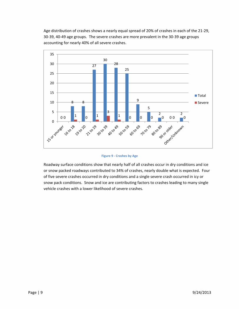
Age distribution of crashes shows a nearly equal spread of 20% of crashes in each of the 21‐29,
30‐39, 40‐49 age groups. The severe crashes are more prevalent in the 30‐39 age groups
accounting for nearly 40% of all severe crashes.
Figure 9 ‐ Crashes by Age
Roadway surface conditions show that nearly half of all crashes occur in dry conditions and ice
or snow packed roadways contributed to 34% of crashes, nearly double what is expected. Four
of five severe crashes occurred in dry conditions and a single severe crash occurred in icy or
snow pack conditions. Snow and ice are contributing factors to crashes leading to many single
vehicle crashes with a lower likelihood of severe crashes.
0
8 8
27
3028
25
9
5
20
20 1 0 1
31 0 0 0 0 0 0
0
5
10
15
20
25
30
35
Total
Severe

Page | 10 9/24/2013
Figure 10 ‐ Crashes by Roadway Condition
2.3 IntersectionAnalysisWhen crash data is broken down by intersection along the USTH 14 corridor, 21 of the 92
crashes occurred at 13 intersections. All of the intersections between Owatonna and Dodge
Center have crash rates that are at or are below expected values for total crashes and critical
crash rates. The Steel and Dodge County Safety Plans were reviewed for safety. The following
were found:
Dodge County
USTH 14 AT CSAH 16 Ranked ‐ 33rd of 104 Risk ‐ 2 Stars (Moderate Risk)
Improvements Considered:
Install Street Light – Complete
Steel County
USTH 14 at CSAH 1 Rank ‐ 21st of 104 Risk ‐ 2 Stars (Moderate Risk)
Improvements Considered:
Install Street Light – Complete
Upgrade Signs – 2010 HSIP
Upgrade Markings – 2010 HSIP
USTH 14 AT CSAH 3 Ranked ‐ 17th of 104 Risk ‐ 2 Stars (Moderate Risk)
Install Street Light – Complete
USTH 14 AT CSAH 5 (west) Ranked ‐ 26rd of 104 Risk ‐ 2 Stars (Moderate Risk))
Install Street Light – Complete
USTH 14 AT CSAH 5 (east) Ranked ‐ 40rd of 104 Risk ‐ 2 Stars (Moderate Risk)
Install Street Light – Complete
45
68
31
02
4
0 0 1 0 00
5
10
15
20
25
30
35
40
45
50
Total
Severe

Page | 11 9/24/2013
2.4 BehavioralFactorsCrash data for USTH 14 between Owatonna and Dodge Center indicates two prevalent
contributing factors; illegal or unsafe speeds (16%) and driver inattention (10%). Over 70% of
the total crashes on the corridor were classified as ‘Other/Unknown’. For the severe crashes,
20% were due to illegal or unsafe speeds, 20% were due to improper lane use and nearly 60%
had an unknown cause. It may be necessary to identify why 60% of severe crashes were listed
as an unknown cause. Seatbelt use was widespread in all crashes, with only three instances
where crash victims were unbelted. These three instances of unbelted drivers did not result in
either a K or A severity. Alcohol related crashes are not an issue on this corridor. The
frequency of occurrence (1%) is much lower than the district average percentage of crashes
(4%) involving alcohol.
2.5 TrafficVolumesTotal traffic volumes along USTH 14 have been slightly decreasing or level from Owatonna to
Dodge Center, and commercial vehicle volumes are decreasing at an even greater rate (2007‐
2011) Expansion of the corridor to a four‐lane facility is currently in development as mentioned
earlier in the report.
Heavy commercial vehicles account for an average of 15.4% (using 2009 and 2011 data) of
total traffic along the corridor which is much higher than I‐90 between I‐35 and TH 56 which
has 9.5% commercial vehicles. This could stem from transit to and from the Madison,
Milwaukee, and Chicago areas and the ability to decrease trip distance by 35 miles using USTH
14 out of Rochester versus the I‐90 to I‐35 route.
Traffic forecasts for the next 20 years (2030) predict that the ADT of the corridor will more than
double to 16,800. This projection was taken from the USTH 14 EIS from Owatonna to Dodge
Center Final Environmental Impact Statement (EIS) and Final Section 4(f) Evaluation published
in 2010, and represents potential volumes with a four‐lane freeway system. The EIS states that
a full realignment may be necessary over the next 20 years (preferred Alternative 3) that routes
USTH 14 south of the Dakota, Minnesota, and Eastern (DM&E) Railroad line. These growth
estimates are based on local development assumptions which are typically aggressive. These
numbers are highly dependent on the economy, and the current outlook is more conservative
than was being projected in the 2010 FEIS. These volumes likely will not be met until some
date beyond the 2030 time horizon.

Page | 12 9/24/2013
Figure 11 ‐ 20 Year LOS and AADT Projections
The corridor currently operates at a LOS of C based on the 2011 traffic volumes. Though
MnDOT does not explicitly detail an acceptable level of service, the existing operation of USTH
14 would be considered acceptable by most standards. By 2030, traffic volumes will grow
reducing the overall level of service experienced by travelers. With the four‐lane expansion
and realignment, the traffic will experience a LOS of A/B.
2.6 CommercialVehiclesThe corridor has a commercial vehicles percentage of 15% traveling this corridor when
compared to interstate highway facilities. The number of crashes involving commercial vehicles
comprises nearly 7% of the total crashes compared to the district wide average of 4%. Most of
the crashes were property damage or non‐life threatening injuries, and there was a fatality
involving a Heavy Commercial Truck. This means that commercial vehicles were involved in half
of the fatal crashes on the corridor from 2007 to 2011. Often times the contributing factor to
the crash is related to an error made by a passenger car. There is not enough crash
information to make a statistically relevant conclusion on truck impacts.
0
10000
20000
30000
40000
50000
60000
70000
US 14 Audit Section Four‐Lane Divided Highway
Level of Service (LOS) versus Traffic Volume (AADT)
LOS E
LOS D
LOS C
LOS B
LOS A2030 AADT Projection
2011 AADT
Source: 2010 Highway Capacity Manual

Page | 13 9/24/2013
3 FieldReviewSummary
3.1 Segments
3.1.1 RoadwayGeometryThe RSAR team studied aerial photography of the USTH 14 corridor to review the existing
geometry. For most of the roadway, the following conditions can be found:
12‐foot lanes.
Paved shoulder for the majority of the corridor, usually 8‐10’ wide.
Clear zones are adequate for the majority of the corridor contain no major
obstructions.
Vertical alignment is nearly flat.
Horizontal alignment is very straight with no sharp curves.
Less than 20% of the roadway is designated as a no‐passing zone.
3.1.2 FieldAccessThe road system divides properties into a one‐square ‐mile grid (section) system. This
allows ample access to farm fields from the local roadways and direct access from USTH 14.
However, USTH 14 is not the primary choice of access for most farmers.
3.1.3 TrafficCharacteristicsIt was observed that during the majority of the daytime hours, passenger vehicles seemed
to have a difficult time passing commercial vehicles. This interaction increases during
agricultural harvesting season when the volume of commercial vehicles and trucks is
significantly higher.
3.2 Intersections
3.2.1 GeometricsMost of the alignment of USTH 14 is directly east/west which makes the majority of
intersections right‐angle. There is a single skewed intersection (SE 64th Avenue). It has been
noted that crash rates at skewed intersections tend to be higher than those that are
perpendicular.
3.2.2 SigningandStriping(PavementMarkings)Throughout the corridor, the epoxy edge line is in need of repair or upgrade. Improved stop
bars and advanced “STOP AHEAD” markings should be considered for side‐street stop
conditions. A review of the Minnesota Best Practices for Traffic Signing Handbook and the
Traffic Safety Fundamentals Book could provide guidance for better signing and safety.
There are not any centerline rumble strips through the Claremont area or the sections of
concrete pavement in the transition zones. Signing at the intersections, especially stop signs
should be reviewed and possibly upgraded to a larger size for better visibility. All signs on
the corridor should be compliant with the 2011 Minnesota Manual on Uniform Traffic
Control Devices (MnMUTCD). There are two dynamic speed display (DSD) signs on either

Page | 14 9/24/2013
end of the corridor at the two‐lane to the four‐lane transition sections, but the sign on the
east end near Dodge Center was not functional during the RSA field review.
4 SuggestedImprovementStrategies
4.1 Corridor‐WideImprovementsThe majority of the crashes along USTH 14 occur in the segments between intersections,
and the severe crashes were mostly related to head‐on collisions. Implementing techniques
to reduce the number of vehicles crossing over the centerline could reduce the number of
severe crashes and likely the total number of crashes as well. There are several techniques
to prevent vehicles from crossing the centerline, and they involve changing the cross section
of the roadway by adding a buffer, adding a lane (turn, bypass or passing) or redesigning the
entire corridor to a four‐lane expressway.
4.1.1 CenterlineRumbleStripesAccording to MnDOT policy, centerline rumble striping should be re‐installed along the
entire corridor as part of the planned corridor‐wide mill and overlay. Installation should also
be considered in the concrete pavement section near Dodge Center. This may reduce the
amount of head on crashes as well as add visibility in wet conditions to the centerline
striping. Additionally, the residential areas in Claremont are 0.3 miles from USTH 14 which
may lessen the noise impact of a vehicle traveling at 55 mph hitting the rumble stripe. The
rumble stripes should be compliant with the latest standards from MnDOT.
4.1.2 Four‐FootCenterlineBufferZone/TubeDelineatorsA center buffer zone between lanes, 4‐8 feet in width, creates an inside buffer zone
between opposing lanes of traffic with rumble strips on the inside lane lines delineating the
buffer zone. The installation of tube delineators allows the zone to be signed as no passing,
but still allow full access at driveways and side streets.
Figure 12 – Center Buffer Zone with Delineators Detail

Page | 15 9/24/2013
The Center Buffer Zone was installed on an experimental basis on USTH 14 in Nicollet
County near Mankato and the effectiveness is still under investigation. It is worth noting
that there have been no crashes during the first 10 months of the Nicollet County
deployment. The benefits of the four‐foot buffer come from the extra recovery time given
to a vehicle that hits the centerline rumble strips and reacts accordingly. This option would
require the use of approximately two feet of shoulder for each direction of travel once the
lanes are reconfigured.
Figure 13 – Center Buffer Zone with Delineators (USTH 14 west of Mankato)
The use of the delineators in the center of the median is a maintenance concern. The
delineator’s primary function is to bring attention to the buffer and restrict passing. The use
of delineators may not be necessary. The 4‐foot buffer zone with rumble strips on the inside
lane lines will give drivers two opportunities to regain focus on the road before crossing into
oncoming traffic if they leave their lane. The research on USTH 14 near Mankato will likely
show clear direction of the use of buffer zones and center‐tube delineators.
The existing shoulder pavement section is currently structurally insufficient to carry mainline
traffic and may have to be reinforced or reconstructed for long term traffic use.
A cable‐style median barrier has been used in other states for delineation/protection in the
buffer zone but was not considered as desirable because of the loss of access and the likely
maintenance needed to repair damaged segments.

Page | 16 9/24/2013
4.1.3 PassingZonesThe public has expressed significant driver frustration created by the perceived inability to
pass slow moving traffic and commercial vehicles. A way to improve the passing conditions
would be to add dedicated passing lanes mid‐corridor to allow vehicles to get past slower
moving traffic. There is enough space with the existing roadway to add a 12’ lane by taking
6 feet of shoulder from each direction of traffic.
Another technique practiced in Sweden is the “2+1” method that may or may not use cable
median barrier. This technique places two full lanes in one direction and one in the other
with a median separation of 4‐feet in which cable barrier can be placed to prevent vehicles
from crossing over to oncoming lanes. This layout allows for vehicles to pass throughout the
corridor as the direction of the 2+1 alternates between travel directions, typically, at one to
two mile intervals. This technique has been used in Europe and has been found to virtually
eliminate head on crashes since it restricts passing to the two‐lane sections and adds cable
barrier to prevent crossover vehicles.
In sections without centerline delineators, local experience has indicated there may be
confusion with drivers entering the 2+1 segment and not knowing what type of roadway
facility they are entering ending up driving on the wrong side of the road. Special
consideration would need to be given to choosing a location of a 2+1 segment such that you
limit the number of intersections crossed and ensure any intersections crossed are low
volume. On the study corridor the roadway network is laid out in one‐mile grids which
would already limit conflicts with side streets and potential wrong way traffic easily
accommodating a 2+1 roadway section.

Page | 17 9/24/2013
As shown in the cross section below, the existing shoulder pavement section is currently
insufficient to carry mainline traffic and would have to be reinforced or reconstructed.
Figure 14 ‐ Existing USTH 14 Pavement Section
4.1.4 CorridorRedesign–Four‐LaneFreewayAs mentioned previously, an EIS has been completed for a potential four‐lane freeway
reconstruction of the entire USTH 14 corridor between Owatonna and Dodge Center mostly
on a new alignment south of Claremont. While this realignment may eliminate some safety
concerns and greatly improve mobility. Construction is likely to take place over numerous
years with numerous smaller projects. While the four‐lane facility is constructed, reduced
conflict intersections could be a possible safety enhancement to at‐grade intersections as
the grade separated intersections are phased in.
4.1.5 WinterMaintenanceDuring winter months, snow packed and ice covered roads were a contributing factor in a
number of crashes. Maintenance personnel from District 6 has also commented that
maintaining clear pavement conditions during snow storms is difficult, and USTH 14 has
required closures in the past. One way to alleviate this is to install living snow fences with
shrubs and trees to trap snow that would otherwise drift onto the roadway. The plowing
forces needed to provide more frequent plowing of this corridor should be evaluated in an

Page | 18 9/24/2013
effort to reduce the likelihood of snow pack buildup and drifting snow during winter
months.
4.1.6 SpeedStudiesIt is evident from stakeholder meetings that the maximum comfortable speed on this
corridor is above 55 miles per hour. The use of Global Positioning System (GPS) technology
in commercial vehicles for fleet management causes unwillingness in commercial truck
drivers to operate at speeds above the speed limit. For many drivers, there is a risk of
possible fines or discipline from their employer. There are speed limit reductions entering
each end of the corridor from 65 mph to 55 mph. If the speed limit were increased to 60
miles per hour for the 55 mph segment, it may ease some driver frustration while bringing
the speed closer to the driver expected speed limit. A study to determine if a 60 mph speed
limit is appropriate for this roadway should be considered.
4.1.7 RailCrossingsThe rail crossing near CSAH 80 has not been involved in any crashes based on 2007 to 2011
data, but with regular train traffic crossing USTH 14, consideration for increased signing and
augmenting visibility of the crossing should be made. There was one crash at this location
prior to 2007, but was not train related and appeared to be more related to the geometric
curve and likely inattentive driving.
It is common to have gates at trunk highway crossings with significant train and/or vehicle
traffic. As a preventative measure, District 6 should work with the MnDOT Rail Division to
determine if gates or additional crossing indications are warranted.
4.2 IntersectionsWhile intersections represent a smaller portion of crash data, there are still improvements
that could be made for the 16 at‐grade crossings between Owatonna and Dodge Center.
4.2.1 Turn/BypassLanesBased on stakeholder meetings, there seems to be a high amount of passing on the shoulder
for vehicles turning left and using the shoulder as a turn lane for right‐turning vehicles.
Identifying what intersections have the highest turning movements and then adding left‐ or
right‐turn lanes or bypass lanes at “T” intersections may improve safety by removing the
turning vehicle from the through lane. Bypass lanes at four‐legged intersections were also
considered ‐ the RSAR team reviewed two reports, “4 Legged Intersections with Bypass
Lanes Study” by Gordon Anderson and “Bypass Lane Safety, Operations and Design Study”
by Howard Preston in order to determine the safety of bypass lanes. Based on before and
after crash data, the study by Preston, et al, published in 1999 recommends that agencies
restrict the use of bypass lanes at three‐ and four‐leg intersections due to an apparent
increase in the severity of crashes. The report by Anderson directly contradicts this
assertion and recommends that agencies can still use bypass lanes if the proper signing and
striping is used, and sees no detrimental effects to roadway safety. Both of these studies
acknowledge the fact that much of the crash data used could be considered statistically

Page | 19 9/24/2013
insignificant because of the low numbers involved. Currently, we would not recommend the
use of bypass lanes at four‐legged intersections due to the lack of solid evidence of
enhanced safety. Driver confusion can occur if a left‐ and right‐turning vehicle are side by
side and a through vehicle accustomed to using the bypass lane does not react to the slow
moving right‐turning vehicle, rear ending the vehicle. Similar confusion can occur if a left‐
turning vehicle is in the through lane and does not properly indicate there turn.
Dedicated left‐turn lanes at CSAH 3 and CSAH 5 would improve driver safety and should be
considered.
4.2.2 SigningandStripingImprovementsThe RSA team noted that many of the stop signs at the minor approaches to intersections
were 30” in size. Visibility of signs should be improved by increasing the size to 36” as
recommended by the MNMUTCD. Stop bars and “STOP AHEAD” (W3‐1) signs could also be
implemented at several of the intersections to improve stopped vehicle positioning and
safety at the intersections.
Additional signing should be considered at transitions from four‐lane to two‐lane at both the
east and west ends of the project. Currently, the merge left signs are located at the merge
point. This signing layout is adequate to meet the MnMUTCD, but additional advanced
warning signs can be beneficial to alerting drivers of the upcoming change in facility type.
The following lane drop signing layout is being used on I‐60 and has been successful:
Not to scale
Figure 15 – Left Lane Drop Advanced Warning
The use of reduce speed ahead signs should be considered for the 65 mph to 55 mph speed
reduction zones on both the east and west ends of the corridor.

Page | 20 9/24/2013
4.3 EnforcementA key strategy with any RSA is effective enforcement of traffic laws. Currently, the
enforcement of the corridor is handled by the Minnesota State Patrol and the local county
sheriff departments. If speed enforcement is identified as a priority, this can be
accomplished through greater patrol presence on USTH 14 or effectively using portable
dynamic speed display “Your Speed Is” signs. However, the Minnesota State Patrol has
stated they do not have the resources for a sustained long‐term speed enforcement
campaign on this corridor.
4.3.1 SeatbeltUsageBased on crash data and information from the highway patrol, the percentage of seatbelt
usage on the corridor is extremely high. It could be beneficial to work with law enforcement
agencies associated with the corridor to ensure seatbelt compliance remains high. Pursuing
assistance from the Towards Zero Death (TZD) coalition could generate some ideas for
public outreach strategies.
4.4 Commercial/FarmVehicleTrafficThe amount of heavy commercial and farm vehicles that regularly use USTH 14 is a concern
to many of the stakeholders. The ethanol plant in Claremont, as well as seasonal harvest
traffic (equipment and semis), can contribute to higher than normal volumes of commercial
and farm vehicles. Since the ADT of the corridor is 7500, opportunities to pass slower
moving vehicles can be hard to find, and may prompt impatient drivers to perform risky
passing maneuvers. Developing education and outreach strategies for local agencies may
help the traveling public make better decisions when driving USTH 14.
5 Segment‐BasedFindingsandSuggestionsThe RSAR team drove the USTH 14 corridor several times and investigated the roadway by dividing it
into seven segments. Segment A was eliminated from the study because the study was focused on
the two‐lane section. Each of the remaining six segments were examined for potential issues and
noticeable safety concerns, and the findings documented by each RSAR member. Subsequently, the
team developed a list of segment‐specific suggestions for the USTH 14 corridor that is described in
the following sub sections.
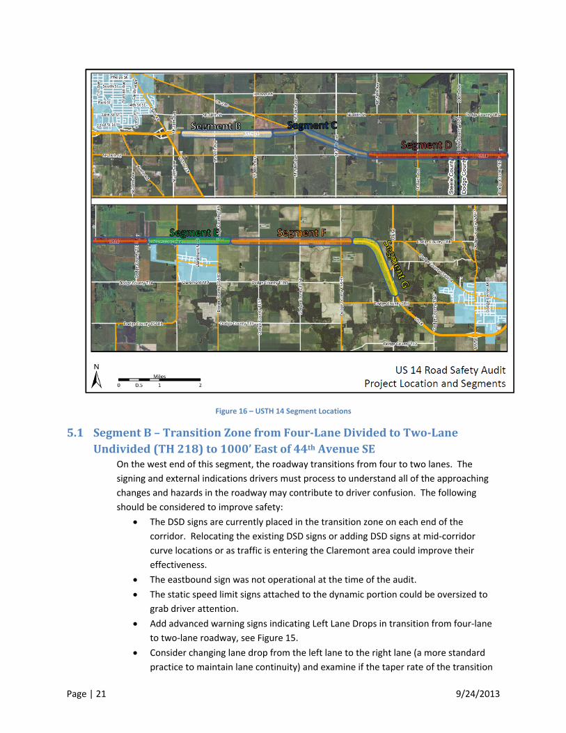
Page | 21 9/24/2013
Figure 16 – USTH 14 Segment Locations
5.1 SegmentB–TransitionZonefromFour‐LaneDividedtoTwo‐LaneUndivided(TH218)to1000’Eastof44thAvenueSE
On the west end of this segment, the roadway transitions from four to two lanes. The
signing and external indications drivers must process to understand all of the approaching
changes and hazards in the roadway may contribute to driver confusion. The following
should be considered to improve safety:
The DSD signs are currently placed in the transition zone on each end of the
corridor. Relocating the existing DSD signs or adding DSD signs at mid‐corridor
curve locations or as traffic is entering the Claremont area could improve their
effectiveness.
The eastbound sign was not operational at the time of the audit.
The static speed limit signs attached to the dynamic portion could be oversized to
grab driver attention.
Add advanced warning signs indicating Left Lane Drops in transition from four‐lane
to two‐lane roadway, see Figure 15.
Consider changing lane drop from the left lane to the right lane (a more standard
practice to maintain lane continuity) and examine if the taper rate of the transition

Page | 22 9/24/2013
zone is correct. This may be accomplished with the scheduled 2015 mill and
overlay.
5.2 SegmentC–1000’Eastof44thAvenueSEto0.5MilesEastof64thAvenueSE
This segment of roadway contains the only at‐grade railroad crossing in the corridor as well
as one of the two curved sections. Suggestions for this segment include:
Improving the intersection lighting at 54th Avenue SE to highlight the intersection
and the approach to the railroad tracks. Intersection lighting at this location may
also improve curve visibility.
Remove the Bump sign at the railroad tracks as there was no noticeable bump while
crossing the tracks (or review for seasonal need).
Figure 17 ‐ Rail Crossing Bump Sign
There are truck‐stopping lanes on the shoulders for hazardous vehicles and busses
at the approaches to the railroad tracks near SE 54th Avenue. The eastbound
acceleration portion of the stopping lane is only 280’ in length with a 1:5 taper rate.
This location is on a curve and adjacent to two intersections in the middle of the
railroad crossing with a posted speed limit of 55 mph. The location of the
eastbound stopping lane in relation to the curve may make it difficult to see
approaching traffic (trucks cannot see behind them with mirrors on an inside lane of
a curve). This design should be reviewed to ensure hazardous vehicles can reach
safe speeds while merging back into traffic. The westbound direction has an
acceleration length of 460’. The MnDOT Rail Division should be consulted to
determine the standard design for a stopping lane at a railroad crossing and review
any additional needs due to the curve.

Page | 23 9/24/2013
.
Figure 18 – Truck/Bus Stopping Lane at RR Crossing
There are no gates at the railroad crossing protecting USTH 14 traffic. District 6
should consider working with the MnDOT Rail Division to identify viable signing and
control improvements at this location.
Figure 19 ‐ WB Approach to RR Crossing
5.3 SegmentD–0.5MilesEastof64thAvenueSEtoWestEndofClaremontThis segment of roadway did not present any obvious safety concerns, and the RSAR team
does not have any recommendations.
5.4 SegmentE–WestEndofClaremonttoEastEndofClaremontThe heavy commercial vehicle activity in this segment is noticeably higher due to the
ethanol plant. This area presents safety issues due to westbound traffic passing the
commercial vehicles on the shoulder at CSAH 3 and drivers using the shoulder on

Page | 24 9/24/2013
northbound CSAH 1 as a right‐turn lane to eastbound USTH 14. Suggested improvements
include:
Adding a right‐turn lane for northbound CSAH 1 traffic heading eastbound on USTH
14. It is very evident that traffic is using the shoulder for a right‐turn lane at this
location.
Add centerline rumble strips or rumble stripes on USTH 14 at the CSAH 1 bypass
zone.
Add a left‐turn lane for CSAH 3 (from EB to NB, or WB to SB or both).
5.5 SegmentF–EastEndofClaremonttoUSTH14Curve(0.5mileseastofCSAH5eastintersection)
There are bypass issues here similar to Segment E, as well as a clear‐zone issue due to
culvert headwalls. Suggested improvements include:
Review new culvert installation and riprap area off of the shoulder on both sides of
USTH 14 just east of CSAH 5. There may be a need for guardrail at this location even
though the obstruction is outside of the standard clear zone.
Add a left‐turn lane for westbound USTH 14 traffic turning left onto southbound
CSAH 5. Vehicles are currently using the shoulder to get around left turning traffic.
Figure 20 ‐ Culvert Headwall
5.6 SegmentG–USTH14CurvetoTransitionZonefromTwoLaneUndividedtoFour‐LaneDividedSouthofTH56
This segment shares many of the same observed issues as Segment B. The transition from
two‐lane undivided highway to a four‐lane expressway may cause some issues for drivers
unfamiliar with the area. Some suggested improvements include:
Adding a centerline rumble strip or rumble striping to the concrete pavement
segment.
The Dynamic Speed Display signs are currently placed in the transition zone on each
end of the corridor. Relocating the existing DSD signs or adding DSD signs at mid‐

Page | 25 9/24/2013
corridor curve locations or as traffic is entering the Claremont area could improve
their effectiveness.
The static speed limit portion of the DSD signs could be oversized to grab driver
attention.
Add advanced warning signs indicating Left Lane Drops in transition from four‐lane
to two‐lane roadway, see Figure 15.
Consider changing lane drop from the left lane to the right lane (a more standard
practice to maintain lane continuity) and examine if the taper rate of the transition
zone is correct. This may be accomplished with the scheduled 2015 mill and
overlay.
6 SummaryThe crash data for the corridor, when analyzed, indicates head‐on crashes are causing the most severe
injuries and deaths. The number of severe crashes is as expected when compared to statewide
averages. Similarly, the overall crash rate is very low when compared to other trunk highways in the
state with similar ADTs. Volumes of heavy commercial vehicles are higher than average. Additionally,
the 7500 vehicle per day on this two‐lane section of highway does not provide many adequate gaps for
safe passing maneuvers. As traffic volumes continue to increase, these gaps will be reduced further,
thus increasing the potential for crashes.
The geometry and surface condition of the roadway does not present many apparent safety hazards,
but there may be a need to add capacity on the roadway for turning movements. More importantly,
adding a centerline buffer zone with yellow tubes and rumble striping throughout much of the corridor
may reduce head‐on collisions.
Potential improvements to the corridor are classified into three different categories: short term,
medium term, and long term. Many of the short‐term improvements could be easily installed today.
Other short‐term and the mid‐term improvements are better considered with the scheduled 2015 mill
and overlay. Long‐term improvements require substantial money and will need continued effort to
implement.
The following table illustrates how some of the potential solutions and improvements mentioned in this
document could be classified.

Page | 26 9/24/2013
Timeline Improvement
Short Term Restriping ‐ Existing striping plan
Centerline rumble strips/stripes
Signing improvements – increased size & additional lane transition advisory signing
Improve four to two lane transition areas to ensure smooth taper rates and right‐ lane drop
Additional DSD sign or relocation
Railroad crossing gate arm consideration
Living snow fences
Guardrail installation
Speed studies
Marketing and outreach efforts relating to heavy commercial vehicle safety
Mid Term Median buffer zone, 48” – Shoulder reconstruction
Added passing lanes
Turn lanes
Median buffer zone, 8’ width – full cross section reconstruction
Long Term Full reconstruction of corridor to four‐lane divided freeway
Reduced conflict intersections at at‐grade intersections while transitioning to freeway section
Figure 21 ‐ Implementation Suggestion Summary