U.S. GEOLOGICAL SURVEY—REDUCING THE RISK · PDF fileFact Sheet 073–97) ... think...
2
U.S. Department of the Interior U.S. Geological Survey USGS Fact Sheet 172–96, version 2.0 Revised June 2000 U.S. GEOLOGICAL SURVEY—REDUCING THE RISK FROM VOLCANO HAZARDS S ince 1980, scientists have moni- tored geologic unrest in Long Valley Caldera and at adjacent Mammoth Mountain, California. After a persistent swarm of earth- quakes beneath Mammoth Mountain in 1989, geologists discovered that large volumes of carbon dioxide (CO 2 ) gas were seeping from be- neath this volcano. This gas is kill- ing trees on the mountain and also can be a danger to people. The U.S. Geological Survey (USGS) continues to study the CO 2 emissions to help protect the public from this invisible potential hazard. Invisible CO 2 Gas Killing Trees at Mammoth Mountain, California Areas of dead and dying trees Areas of dead and dying trees at Mammoth Mountain vol- cano total more than 100 acres. In 1990, the year after a per- sistent swarm of small earthquakes occurred beneath the volcano, U.S. Forest Service rangers first noticed areas of tree kill. When U.S. Geological Survey scientists investigated, they discovered that the trees are being killed by high con- centrations of CO 2 gas in the soil. The seepage of CO 2 gas from below Mammoth Mountain and the continued occur- rence of local earthquakes are signs of the ongoing geologic unrest in the area. The upper part of the 11,053-foot-high vol- cano (above 9,500 feet) is shown in darker shades of green. Mammoth Mountain is a young volcano on the southwest rim of Long Valley Caldera, a large volcanic depression in eastern California. The Long Valley area, well known for its superb skiing, hiking, and camping, has been volcanically active for about 4 million years. The most recent volcanic eruptions in the region occurred about 200 years ago, and earthquakes fre- quently shake the area. Because of this, the U.S. Geological Survey (USGS) operates an extensive network of instruments to monitor the continuing unrest in the Long Valley area. Numerous small earthquakes occurred be- neath Mammoth Mountain from May to No- vember 1989. Data collected from monitor- ing instruments during those months indi- cated that a small body of magma (molten rock) was rising through a fissure beneath the mountain. During the next year, U.S. Forest Service rangers noticed areas of dead and dy- ing trees on the mountain. After drought and insect infestations were eliminated as causes, a geologic explanation was suspected. USGS scientists then made measurements and dis- covered that the roots of the trees were being killed by exceptionally high concentrations of carbon dioxide (CO 2 ) gas in the soil. To- day, areas of dead and dying trees at Mam- moth Mountain total more than 100 acres. The town of Mammoth Lakes, just east of this volcano, has not been affected. Although leaves of plants produce oxygen (O 2 ) from CO 2 during photosynthesis, their roots need to absorb O 2 directly. The high CO 2 concentrations in the soil on Mammoth Moun- tain are killing trees by denying their roots O 2 and by interfering with nutrient uptake. In the areas of tree kill, CO 2 makes up about 20 Lake Crowley Convict Lake Mammoth Lakes Mammoth Mountain Inyo Craters volcanic chain 395 LONG VALLEY CALDERA H o t C r e e k M a m m o th C r e e k O w e ns R i v e r INDEX MAP CALIF 0 5 KILOMETERS 0 5 MILES Area of tree kill CO 2 -charged cold spring CO 2 -charged hot spring Well with high dissolved CO 2 Steam vent Fault Horseshoe Lake Reds Lake Mammoth Mountain Boun d a r y Cr e e k Re ds C r e e k D r y C r e e k Lak e M ar y Ro a d 203 1 MILE 0 1 KILOMETER 0 Mammoth Mountain, a young volcano in eastern California, sits on the southwest rim of Long Valley Caldera. In 1994, scientists detected high concentrations of CO 2 gas in the soil on Mammoth Mountain. This invisible gas, seeping from beneath the volcano, is killing trees on the sides of the mountain and can pose a threat to humans. Recent measurements indicate that the total rate of CO 2 gas emission at Mammoth Mountain is close to 300 tons per day. In this photo, large areas of dead and dying trees are visible near Horseshoe Lake, on the southeast flank of Mammoth Mountain. (Copyrighted photo courtesy of John D. Rogie.)
-
Upload
duongduong -
Category
Documents
-
view
212 -
download
0
Transcript of U.S. GEOLOGICAL SURVEY—REDUCING THE RISK · PDF fileFact Sheet 073–97) ... think...

U.S. Department of the InteriorU.S. Geological Survey
USGS Fact Sheet 172–96, version 2.0Revised June 2000
U.S. GEOLOGICAL SURVEY—REDUCING THE RISK FROM VOLCANO HAZARDS
S ince 1980, scientists have moni-tored geologic unrest in Long
Valley Caldera and at adjacentMammoth Mountain, California.After a persistent swarm of earth-quakes beneath Mammoth Mountainin 1989, geologists discovered thatlarge volumes of carbon dioxide(CO2 ) gas were seeping from be-neath this volcano. This gas is kill-ing trees on the mountain and alsocan be a danger to people. The U.S.Geological Survey (USGS) continuesto study the CO2 emissions to helpprotect the public from this invisiblepotential hazard.
Invisible CO2 Gas Killing Trees at MammothMountain, California
Areas ofdead and
dying trees
Areas of dead and dying trees at Mammoth Mountain vol-cano total more than 100 acres. In 1990, the year after a per-sistent swarm of small earthquakes occurred beneath thevolcano, U.S. Forest Service rangers first noticed areas oftree kill. When U.S. Geological Survey scientists investigated,they discovered that the trees are being killed by high con-centrations of CO2 gas in the soil. The seepage of CO2 gasfrom below Mammoth Mountain and the continued occur-rence of local earthquakes are signs of the ongoing geologicunrest in the area. The upper part of the 11,053-foot-high vol-cano (above 9,500 feet) is shown in darker shades of green.
Mammoth Mountain is a young volcanoon the southwest rim of Long ValleyCaldera, a large volcanic depression ineastern California. The Long Valley area,well known for its superb skiing, hiking,and camping, has been volcanically activefor about 4 million years. The most recentvolcanic eruptions in the region occurredabout 200 years ago, and earthquakes fre-quently shake the area. Because of this, theU.S. Geological Survey (USGS) operates anextensive network of instruments to monitor
the continuing unrest in the Long Valley area.Numerous small earthquakes occurred be-
neath Mammoth Mountain from May to No-vember 1989. Data collected from monitor-
ing instruments during those months indi-cated that a small body of magma (moltenrock) was rising through a fissure beneath themountain. During the next year, U.S. ForestService rangers noticed areas of dead and dy-ing trees on the mountain. After drought andinsect infestations were eliminated as causes,a geologic explanation was suspected. USGSscientists then made measurements and dis-covered that the roots of the trees were beingkilled by exceptionally high concentrationsof carbon dioxide (CO
2) gas in the soil. To-
day, areas of dead and dying trees at Mam-moth Mountain total more than 100 acres.The town of Mammoth Lakes, just east ofthis volcano, has not been affected.
Although leaves of plants produce oxygen(O
2) from CO
2 during photosynthesis, their
roots need to absorb O2 directly. The high CO
2
concentrations in the soil on Mammoth Moun-tain are killing trees by denying their roots O
2
and by interfering with nutrient uptake. Inthe areas of tree kill, CO
2 makes up about 20
LakeCrowley
Convict Lake
MammothLakes
MammothMountain
InyoCraters
volcanicchain
395
LONG VALLEY
CALDERA
Hot Cre
ek
Mamm oth Creek
Owens River
INDEXMAPCALIF
0 5 KILOMETERS
0 5 MILES
Area of tree killCO2-charged cold springCO2-charged hot spring
Well with high dissolved CO2Steam ventFault
Horseshoe Lake
Reds Lake
MammothMountain
Boundary CreekReds Creek
Dry
Cre
ek
Lake
Mar
yR
oad
203
1 MILE0
1 KILOMETER 0
Mammoth Mountain, a young volcano in eastern California, sits on the southwest rim of Long Valley Caldera.In 1994, scientists detected high concentrations of CO2 gas in the soil on Mammoth Mountain. This invisiblegas, seeping from beneath the volcano, is killing trees on the sides of the mountain and can pose a threat tohumans. Recent measurements indicate that the total rate of CO2 gas emission at Mammoth Mountain isclose to 300 tons per day. In this photo, large areas of dead and dying trees are visible near Horseshoe Lake,on the southeast flank of Mammoth Mountain. (Copyrighted photo courtesy of John D. Rogie.)
CO2 GASAbove ground
Below ground
COOPERATING ORGANIZATIONSMammoth Mountain Ski Area
Town of Mammoth LakesU.S. Department of Agriculture, Forest Service
Pennsylvania State University
Michael L. Sorey, Christopher D. Farrar,Terrance M. Gerlach, Kenneth A. McGee,
William C. Evans, Elizabeth M. Colvard, David P. Hill,Roy A. Bailey, John D. Rogie, James W. Hendley II, and
Peter H. Stauffer
Graphic design bySusan Mayfield and Sara BooreBanner design by Bobbie Myers
Mammoth Mountain
Fault
Trapping layerof rock
TrappedCO2 gas
Magma
Snowbank
Depression
Dyingtrees
Fault
Basement
Printed on recycled paper
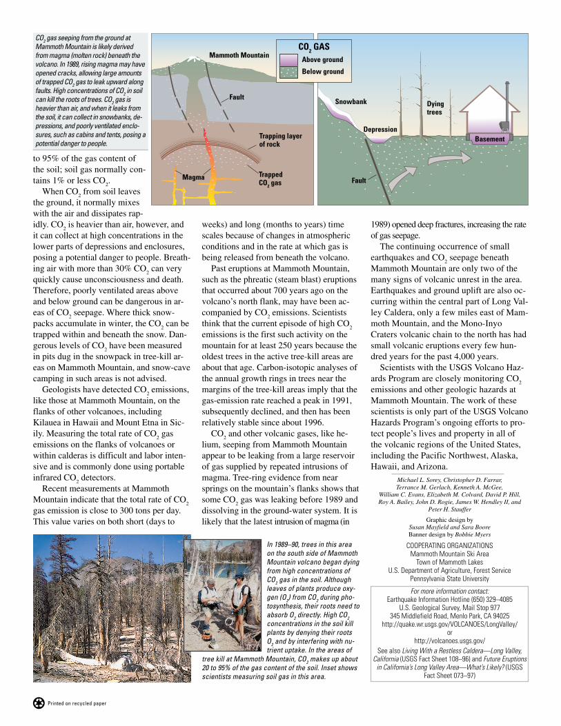
CO2 gas seeping from the ground atMammoth Mountain is likely derivedfrom magma (molten rock) beneath thevolcano. In 1989, rising magma may haveopened cracks, allowing large amountsof trapped CO2 gas to leak upward alongfaults. High concentrations of CO2 in soilcan kill the roots of trees. CO2 gas isheavier than air, and when it leaks fromthe soil, it can collect in snowbanks, de-pressions, and poorly ventilated enclo-sures, such as cabins and tents, posing apotential danger to people.
In 1989–90, trees in this areaon the south side of MammothMountain volcano began dyingfrom high concentrations ofCO2 gas in the soil. Althoughleaves of plants produce oxy-gen (O2) from CO2 during pho-tosynthesis, their roots need toabsorb O2 directly. High CO2concentrations in the soil killplants by denying their rootsO2 and by interfering with nu-trient uptake. In the areas of
tree kill at Mammoth Mountain, CO2 makes up about20 to 95% of the gas content of the soil. Inset showsscientists measuring soil gas in this area.
For more information contact:Earthquake Information Hotline (650) 329–4085
U.S. Geological Survey, Mail Stop 977345 Middlefield Road, Menlo Park, CA 94025
http://quake.wr.usgs.gov/VOLCANOES/LongValley/or
http://volcanoes.usgs.gov/See also Living With a Restless Caldera—Long Valley,
California (USGS Fact Sheet 108–96) and Future Eruptionsin California’s Long Valley Area—What’s Likely? (USGS
Fact Sheet 073–97)
to 95% of the gas content ofthe soil; soil gas normally con-tains 1% or less CO
2.
When CO2 from soil leaves
the ground, it normally mixeswith the air and dissipates rap-
weeks) and long (months to years) timescales because of changes in atmosphericconditions and in the rate at which gas isbeing released from beneath the volcano.
Past eruptions at Mammoth Mountain,such as the phreatic (steam blast) eruptionsthat occurred about 700 years ago on thevolcano’s north flank, may have been ac-companied by CO
2 emissions. Scientists
think that the current episode of high CO2
emissions is the first such activity on themountain for at least 250 years because theoldest trees in the active tree-kill areas areabout that age. Carbon-isotopic analyses ofthe annual growth rings in trees near themargins of the tree-kill areas imply that thegas-emission rate reached a peak in 1991,subsequently declined, and then has beenrelatively stable since about 1996.
CO2 and other volcanic gases, like he-
lium, seeping from Mammoth Mountainappear to be leaking from a large reservoirof gas supplied by repeated intrusions ofmagma. Tree-ring evidence from nearsprings on the mountain’s flanks shows thatsome CO
2 gas was leaking before 1989 and
dissolving in the ground-water system. It islikely that the latest intrusion of magma (in
1989) opened deep fractures, increasing the rateof gas seepage.
The continuing occurrence of smallearthquakes and CO
2 seepage beneath
Mammoth Mountain are only two of themany signs of volcanic unrest in the area.Earthquakes and ground uplift are also oc-curring within the central part of Long Val-ley Caldera, only a few miles east of Mam-moth Mountain, and the Mono-InyoCraters volcanic chain to the north has hadsmall volcanic eruptions every few hun-dred years for the past 4,000 years.
Scientists with the USGS Volcano Haz-ards Program are closely monitoring CO
2
emissions and other geologic hazards atMammoth Mountain. The work of thesescientists is only part of the USGS VolcanoHazards Program’s ongoing efforts to pro-tect people’s lives and property in all ofthe volcanic regions of the United States,including the Pacific Northwest, Alaska,Hawaii, and Arizona.
idly. CO2 is heavier than air, however, and
it can collect at high concentrations in thelower parts of depressions and enclosures,posing a potential danger to people. Breath-ing air with more than 30% CO
2 can very
quickly cause unconsciousness and death.Therefore, poorly ventilated areas aboveand below ground can be dangerous in ar-eas of CO
2 seepage. Where thick snow-
packs accumulate in winter, the CO2 can be
trapped within and beneath the snow. Dan-gerous levels of CO
2 have been measured
in pits dug in the snowpack in tree-kill ar-eas on Mammoth Mountain, and snow-cavecamping in such areas is not advised.
Geologists have detected CO2 emissions,
like those at Mammoth Mountain, on theflanks of other volcanoes, includingKilauea in Hawaii and Mount Etna in Sic-ily. Measuring the total rate of CO
2 gas
emissions on the flanks of volcanoes orwithin calderas is difficult and labor inten-sive and is commonly done using portableinfrared CO
2 detectors.
Recent measurements at MammothMountain indicate that the total rate of CO
2
gas emission is close to 300 tons per day.This value varies on both short (days to