![INDEX [reliefweb.int]reliefweb.int/sites/reliefweb.int/files/resources/maps_index.pdf · INDEX Index Health facility name Functional Status Health facility type Structure Type 0 1000](https://static.fdocuments.us/doc/165x107/5e89a2a5e988f11bf13a6b08/index-index-index-health-facility-name-functional-status-health-facility-type.jpg)
U.S. GEOLOGICAL SURVEY M6.4 and 6.3 Indonesian...
1
Map prepared by U.S. Geological Survey National Earthquake Information Center 2007 Map not approved for release by Director USGS EARTHQUAKE SUMMARY MAP XXX U.S. DEPARTMENT OF THE INTERIOR U.S. GEOLOGICAL SURVEY DISCLAIMER Base map data, such as place names and political boundaries, are the best available but may not be current or may contain inaccuracies and therefore should not be regarded as having official significance. Nicobar Islands INDONESIA SUMATERA S U N D A T R EN C H Great Nicobar S t r a i t o f Ma l a c ca Nias PENINSULAR MALAYSIA SINGAPORE THAILAND Simuelue Siberut TANDJUNGPANDAN PLABJU PALEMBANG DJAMBI PADANG BUKITTINGGI PAKANBARU TANDJUNG PINANG DUMAI MELAKA KUALA LUMPUR KOTANOPAN MEDAN GEORGETOWN ALOR SETAR SONGKHLA LHOKSEUMAWE BANDA ACEH 95° 95° 100° 100° 105° 105° 0° 5° 5° INDIAN OCEAN INDIA INDONESIA SRI LANKA MALAYSIA VIET- NAM CAMBODIA THAILAND MYANMAR LAOS CHINA BANGLA- DESH SINGAPORE ANDAMAN SEA SOUTH CHINA SEA Bay of Bengal INDIA PLATE AUSTRALIA PLATE BURMA MICROPLATE SUNDA PLATE YANGTZE PLATE NINETYEAST RIDGE S U NDA T R ENCH Andaman Is. Nicobar Is. Investigator Ridge Chennai (Madras) Jakarta Krung Thep (Bangkok) Kolkata (Calcutta) Yangon (Rangoon) Singapore Colombo Phnom Penh Dhaka Kuala Lumpur Hanoi Sumatra Andaman Basin DETAILED MAP Mid-Indian Basin Cocos Basin Viangchan (Vientiane) 65 mm/yr 68 mm/yr 61 mm/yr 59 mm/yr 2004 2007 80° 80° 90° 90° 100° 100° 0° 0° 10° 10° 20° 20° M6.4 and 6.3 Indonesian Earthquakes of 6 March 2007 0 200 400 600 800 100 Kilometers SCALE 1:5,500,000 at the Equator Mercator Projection INDIAN OCEAN INDIA INDONESIA SRI LANKA MALAYSIA VIET- NAM CAMBODIA THAILAND MYANMAR LAOS CHINA BANGLA- DESH SINGAPORE ANDAMAN SEA SOUTH CHINA SEA Bay of Bengal Andaman Is. Nicobar Is. Chennai (Madras) Jakarta Krung Thep (Bangkok) Kolkata (Calcutta) Yangon (Rangoon) Singapore Colombo Phnom Penh Dhaka Kuala Lumpur Hanoi Sumatra DETAILED MAP Viangchan (Vientiane) 2004 2007 80° 80° 90° 90° 100° 100° 0° 0° 10° 10° 20° 20° INDIAN OCEAN INDIA INDONESIA SRI LANKA MALAYSIA VIET- NAM CAMBODIA THAILAND MYANMAR LAOS CHINA BANGLA- DESH SINGAPORE ANDAMAN SEA SOUTH CHINA SEA Bay of Bengal NINETYEAST RIDGE S U ND A T R EN CH Andaman Is. Nicobar Is. Investigator Ridge Chennai (Madras) Jakarta Krung Thep (Bangkok) Kolkata (Calcutta) Yangon (Rangoon) Singapore Colombo Phnom Penh Dhaka Kuala Lumpur Hanoi Sumatera Andaman Basin DETAILED MAP Cocos Basin Viangchan (Vientiane) 2007 2004 1887 1884 1883 1883 1881 1875 1869 186 1861 1858 1847 1843 1834 1833 1814 1762 1761 1755 1750 1737 1577 460 80° 90° 90° 100° 100° 0° 0° 10° 10° 20° 20° DATA SOURCES EARTHQUAKES AND SEISMIC HAZARD USGS, National Earthquake Information Center NOAA, National Geophysical Data Center IASPEI, Centennial Catalog (1900 - 1999) and extensions (Engdahl and Villaseñor, 2002) HDF (unpublished earthquake catalog) (Engdahl, 2003) Global Seismic Hazard Assessment Program PLATE TECTONICS AND FAULTS PB2002 (Bird, 2003) Pubellier and others, 2003 Historical rupture zones (Zachariasen and others, 1999; Ortiz and Bilham, 2003) VOLCANOES Smithsonian Institution, Global Volcano Program BASE MAP NIMA and ESRI, Digital Chart of the World USGS, EROS Data Center OTHER SOURCES Associated Press UN Office for Coordination of Humanitarian Affairs (OCHA) REFERENCES Bird, P., 2003, An updated digital model of plate boundaries: Geochem. Geophys. Geosyst., v. 4, no. 3, pp. 1027- 80. Engdahl, E.R. and Villaseñor, A., 2002, Global Seismicity: 1900 - 1999, chap. 41 of Lee, W.H.K., and others,eds., International Earthquake and Engineering Seismology, Part A: New York, N.Y., Elsevier Academeic Press, 932 p. Engdahl, E.R., Van der Hilst, R.D., and Buland, R.P., 1998, Global teleseismic earthquake relocation with improved trav- el times and procedures for depth determination: Bull. Seism. Soc. Amer., v. 88, p. 722-743. Ortiz, M. and Bilham, R., 2003, Source area and rupture pa- rameters of the 31 December 1881 Mw = 7.9 Car Nicobar earthquake estimated from tsunamis recorded in the Bay of Bengal: Jour. Geophys. Res., v. 108, p. 2215-2231. Pubellier, M., Ego, F., Chamot-Rooke, N., and Rangin, C., 2003, The building of pericratonic mountain ranges: structur- al and kinematic constraints applied to GIS-based reconstruct- ions of SE Asia: Bull. Soc. Geol. France, v. 174, p. 561-584. Zachariasen, J. and others, 1999, Submergence and uplift associated with the giant 1833 Sumatran subduction zone earthquake: Evidence from coral microatolls: J. Geophys. Res., v. 104, p. 895-919. 0 400 800 1,200 1,600 200 Kilometers 0 400 800 1,200 1,600 200 Kilometers SCALE 1:20,000,000 at the Equator SCALE 1:20,000,000 at the Equator 0 400 800 1,200 1,600 200 Kilometers SCALE 1:20,000,000 at the Equator EXPLANATION 6 March 2007 26 December 2004 Earthquakes M ≥ 6 0 - 69 km 70 - 299 300 - 700 Historical Earthquakes Pre-1900 Volcanoes Plate Boundaries Seismic hazard is expressed as peak ground acceleration (PGA) on firm rock, in meters/sec², expected to be exceeded in a 50-yr period with a probability of 10 percent. Prepared in cooperation with the Global Seismographic Network RELATIVE PLATE MOTIONS The broad red vectors represent the motion of the India and Australia plates with respect to the interior of the Eurasia plate. The motion of India and Australia generally northward with respect toEurasia produces motion of many smaller plates that lie between the India/Australia plates and the Eurasia plate. The 26 December 2004 earthquake occurred on the boundary between one of the smaller plates, the Burma microplate, and the India plate. The earthquakes of 6 March 2007 occurred on the Sunda plate. EXPLANATION 6 March 2007 26 December 2004 Volcanoes Seismic Hazard 0 - 0.2 m/sec² 0.2 - 0.4 0.4 - 0.8 0.8 - 1.6 1.6 - 3.2 3.2 - 6.4 6.4 - 9.7 Tectonic Setting Seismic Hazard Seismicity Epicentral Region SUMATRA - ANDAMAN ISLANDS 26 December 2004 00:58:53.45 UTC 3.295° N., 95.982° E. Depth 30 km Magnitude = 9.0 (HRV) . SOUTHERN SUMATRA, INDONESIA 6 March 2007, 03:49:40 UTC 0.472° S., 100.574° E. Depth 30 km fixed Magnitude = 6.4 (USGS) 6 March 2007, 05:49:29 UTC 0.458° S, 100.524° E Depth 30 km fixed Magnitude 6.3 (USGS) . DISCUSSION The locations and focal-mechanisms of the Sumatra earthquakes of March 6, 2007, are consistent with these shocks occurring on the Sumatran fault, a 1900 km-long strike-slip fault that extends the length of the island. At the latitude of the earthquake, the average long- term rate of displacement on the fault is about 20 mm/yr. The exact position of the 2007 earthquakes with respect to earlier historic earthquakes on the Sumatran fault will not be known until detailed studies have been conducted of the recent earthquakes. Two earthquakes having magnitudes of 7.2 and 7.5, respectively, occurred within seven hours of each other on June 8-9, 1943, with epicenters assigned to the section of the fault immediately to the southeast of the epicenters of the 2007 earthquakes. The magnitude 7.5 shock was among the largest earthquakes to have occurred on the Sumatran fault since the late nineteenth century. Two earthquakes that occurred within three hours of each other on June 28, 1926, which have been assigned magnitudes of 6 ½ and 6 ¾ respectively, have been assigned epicenters virtually identical to the epicenters of the 2007 earthquakes. The tectonics of west-central Sumatra are dominated by the motion of the Australia plate northward with respect to the Sunda plate at a velocity of about 50 mm/yr. The principal plate boundary is taken to be the axis of the Sunda trench, but significant plate-boundary deformation occurs in a zone that extends hundreds of kilometers inland from the Sunda trench. The component of motion of relative plate motion that is perpendicular to the trend of the plate-boundary is mostly accommodated by underthrusting along the Sumatra subduction zone, which dips eastward from the Sunda trench and is seismically active to depths of over 200 km in west-central Java. The Sumatra subduction zone has historically produced great thrust-fault earthquakes. The component of relative plate motion that is parallel to the plate-boundary is substantially accommodated by strike-slip faulting on the Sumatra fault, which is about 300 km inland of the Sunda trench. The part of the Sunda plate that lies to the west of the Sumatra fault and east of the principal plate boundary at the Sunda trench is sometimes called the “forearc sliver” of the Sunda plate, being distinguished from the rest of the Sunda plate because of its relative motion with respect to the plate's interior. EXPLANATION 6 March 2007 26 December 2004 Earthquake Magnitude 4.00 - 5.90 5.91 - 6.90 6.91 - 7.90 7.91 - 8.90 8.91 - 9.90 Earthquake Depth 0 - 69 70 - 299 300 - 700 Volcano
Transcript of U.S. GEOLOGICAL SURVEY M6.4 and 6.3 Indonesian...
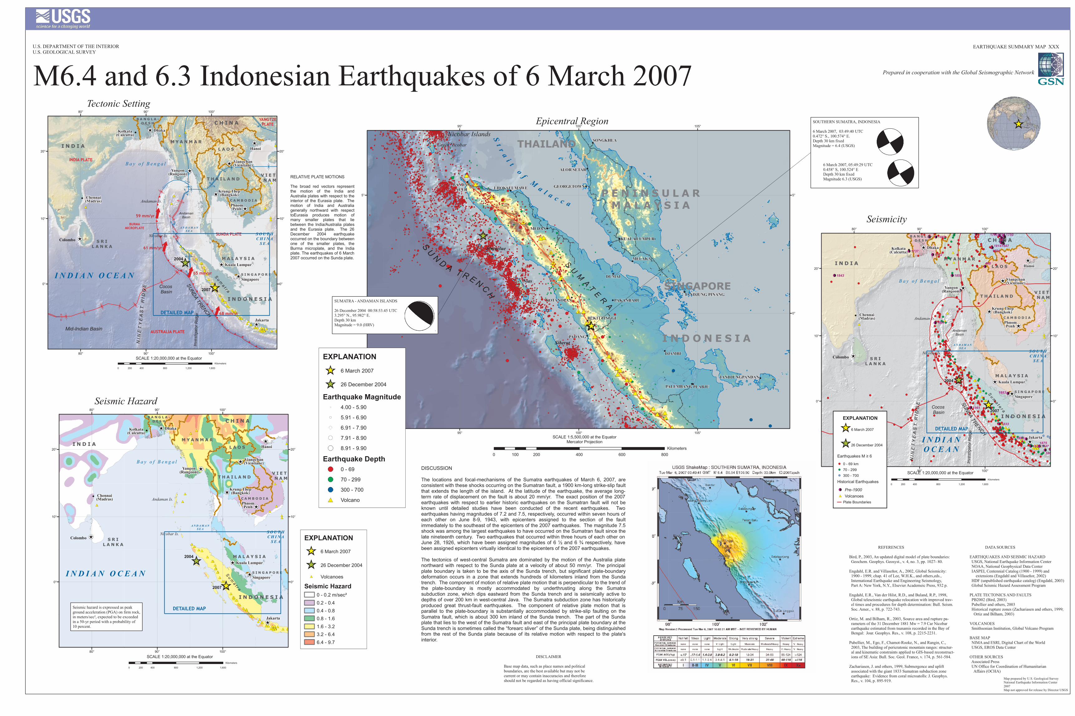
Map prepared by U.S. Geological SurveyNational Earthquake Information Center2007Map not approved for release by Director USGS
EARTHQUAKE SUMMARY MAP XXXU.S. DEPARTMENT OF THE INTERIORU.S. GEOLOGICAL SURVEY
DISCLAIMERBase map data, such as place names and politicalboundaries, are the best available but may not be current or may contain inaccuracies and thereforeshould not be regarded as having official significance.
Nicobar Islands
I N D O N E S I A
S U M A T E R A
S U N D A T R E N C H
Great Nicobar
S t r a i t o f M a l a c c a
Nias
P E N I N S U L A RM A L A Y S I A
SINGAPORE
THAILAND
Simuelue
Siberut
TANDJUNGPANDAN
PLABJUPALEMBANG
DJAMBI
PADANG
BUKITTINGGI
PAKANBARUTANDJUNG PINANG
DUMAI
MELAKA
KUALA LUMPUR
KOTANOPAN
MEDAN
GEORGETOWN
ALOR SETAR
SONGKHLA
LHOKSEUMAWEBANDAACEH
95°
95°
100°
100°
105°
105°
0° 0°
5° 5°
I N D I A N O C E A N
I N D I A
I N D O N E S I A
S R IL A N K A
M A L A Y S I A
V I E T -N A M
C A M B O D I A
T H A I L A N D
M Y A N M A RL A O S
C H I N AB A N G L A -D E S H
S I N G A P O R E
A N D A M A NS E A S O U T H
C H I N AS E A
B a y o f B e n g a lINDIA PLATE
AUSTRALIA PLATE
BURMAMICROPLATE
SUNDA PLATE
YANGTZEPLATE
N IN
E TY E
A ST
R ID G
E SUNDA TRENCH
Andaman Is.
Nicobar Is.
Inves
tigato
r Ridg
eChennai(Madras)
Jakarta
Krung Thep(Bangkok)
Kolkata(Calcutta)
Yangon(Rangoon)
Singapore
Colombo
PhnomPenh
Dhaka
Kuala Lumpur
Hanoi
S u m a t r a
AndamanBasin
DETAILED MAP
Mid-Indian Basin
Cocos Basin
Viangchan(Vientiane)
65 mm/yr
68 mm/yr
61 mm/yr
59 mm/yr
2004
2007
80°
80°
90°
90°
100°
100°
0° 0°
10° 10°
20° 20°
M6.4 and 6.3 Indonesian Earthquakes of 6 March 2007
0 200 400 600 800100Kilometers
SCALE 1:5,500,000 at the EquatorMercator Projection
0°
10°
20°
I N D I A N O C E A N
I N D I A
I N D O N E S I A
S R IL A N K A
M A L A Y S I A
V I E T -N A M
C A M B O D I A
T H A I L A N D
M Y A N M A RL A O S
C H I N AB A N G L A -D E S H
S I N G A P O R E
A N D A M A NS E A S O U T H
C H I N AS E A
B a y o f B e n g a l
Andaman Is.
Nicobar Is.
Chennai(Madras)
Jakarta
Krung Thep(Bangkok)
Kolkata(Calcutta)
Yangon(Rangoon)
Singapore
Colombo
PhnomPenh
Dhaka
Kuala Lumpur
Hanoi
S u m a t r a
DETAILED MAP
Viangchan(Vientiane)
2004
2007
80°
80°
90°
90°
100°
100°
0° 0°
10° 10°
20° 20°
I N D I A NO C E A N
I N D I A
I N D O N E S I A
S R IL A N K A
M A L A Y S I A
V I E T -N A M
C A M B O D I A
T H A I L A N D
M Y A N M A RL A O S
C H I N AB A N G L A -D E S H
S I N G A P O R E
A N D A M A NS E A S O U T H
C H I N AS E A
B a y o f B e n g a l
N IN
E TY E
A ST
R ID G
E SUNDA TRENCH
Andaman Is.
Nicobar Is.
Inves
tigato
r Ridg
e
Chennai(Madras)
Jakarta
Krung Thep(Bangkok)
Kolkata(Calcutta)
Yangon(Rangoon)
Singapore
Colombo
PhnomPenh
Dhaka
Kuala Lumpur
Hanoi
S u m a t e r a
AndamanBasin
DETAILED MAP
Mid-Indian Basin
Cocos Basin
Viangchan(Vientiane)
2007
2004
18871884
1883
1883
1881
1875
1869
1863
1861
1858
1847
1843
18401834
1833
1814
1762
17611755 1750
1737
16801577
460
80°
80°
90°
90°
100°
100°
0° 0°
10° 10°
20° 20°
DATA SOURCESEARTHQUAKES AND SEISMIC HAZARD USGS, National Earthquake Information Center NOAA, National Geophysical Data Center IASPEI, Centennial Catalog (1900 - 1999) and extensions (Engdahl and Villaseñor, 2002) HDF (unpublished earthquake catalog) (Engdahl, 2003) Global Seismic Hazard Assessment ProgramPLATE TECTONICS AND FAULTS PB2002 (Bird, 2003) Pubellier and others, 2003 Historical rupture zones (Zachariasen and others, 1999; Ortiz and Bilham, 2003)VOLCANOES Smithsonian Institution, Global Volcano ProgramBASE MAP NIMA and ESRI, Digital Chart of the World USGS, EROS Data CenterOTHER SOURCES Associated Press UN Office for Coordination of Humanitarian Affairs (OCHA)
REFERENCESBird, P., 2003, An updated digital model of plate boundaries: Geochem. Geophys. Geosyst., v. 4, no. 3, pp. 1027- 80.Engdahl, E.R. and Villaseñor, A., 2002, Global Seismicity: 1900 - 1999, chap. 41 of Lee, W.H.K., and others,eds., International Earthquake and Engineering Seismology, Part A: New York, N.Y., Elsevier Academeic Press, 932 p.Engdahl, E.R., Van der Hilst, R.D., and Buland, R.P., 1998, Global teleseismic earthquake relocation with improved trav- el times and procedures for depth determination: Bull. Seism. Soc. Amer., v. 88, p. 722-743.Ortiz, M. and Bilham, R., 2003, Source area and rupture pa- rameters of the 31 December 1881 Mw = 7.9 Car Nicobar earthquake estimated from tsunamis recorded in the Bay of Bengal: Jour. Geophys. Res., v. 108, p. 2215-2231.Pubellier, M., Ego, F., Chamot-Rooke, N., and Rangin, C., 2003, The building of pericratonic mountain ranges: structur- al and kinematic constraints applied to GIS-based reconstruct- ions of SE Asia: Bull. Soc. Geol. France, v. 174, p. 561-584.Zachariasen, J. and others, 1999, Submergence and uplift associated with the giant 1833 Sumatran subduction zone earthquake: Evidence from coral microatolls: J. Geophys. Res., v. 104, p. 895-919.
0 400 800 1,200 1,600200Kilometers
0 400 800 1,200 1,600200Kilometers
SCALE 1:20,000,000 at the Equator
SCALE 1:20,000,000 at the Equator
0 400 800 1,200 1,600200Kilometers
SCALE 1:20,000,000 at the Equator
EXPLANATION6 March 2007
26 December 2004
Earthquakes M ≥ 60 - 69 km70 - 299300 - 700
Historical EarthquakesPre-1900Volcanoes
Plate Boundaries
Seismic hazard is expressed as peak ground acceleration (PGA) on firm rock,in meters/sec², expected to be exceededin a 50-yr period with a probability of 10 percent.
Prepared in cooperation with the Global Seismographic Network
RELATIVE PLATE MOTIONSThe broad red vectors representthe motion of the India andAustralia plates with respect to theinterior of the Eurasia plate. Themotion of India and Australiagenerally northward with respecttoEurasia produces motion ofmany smaller plates that liebetween the India/Australia platesand the Eurasia plate. The 26December 2004 earthquakeoccurred on the boundary betweenone of the smaller plates, theBurma microplate, and the Indiaplate. The earthquakes of 6 March2007 occurred on the Sunda plate.
EXPLANATION6 March 2007
26 December 2004Volcanoes
Seismic Hazard0 - 0.2 m/sec²0.2 - 0.40.4 - 0.80.8 - 1.61.6 - 3.23.2 - 6.46.4 - 9.7
Tectonic Setting
Seismic Hazard
Seismicity
Epicentral Region
SUMATRA - ANDAMAN ISLANDS26 December 2004 00:58:53.45 UTC3.295° N., 95.982° E.Depth 30 kmMagnitude = 9.0 (HRV) .
SOUTHERN SUMATRA, INDONESIA6 March 2007, 03:49:40 UTC0.472° S., 100.574° E.Depth 30 km fixedMagnitude = 6.4 (USGS)
6 March 2007, 05:49:29 UTC 0.458° S, 100.524° E Depth 30 km fixed Magnitude 6.3 (USGS) .
DISCUSSIONThe locations and focal-mechanisms of the Sumatra earthquakes of March 6, 2007, areconsistent with these shocks occurring on the Sumatran fault, a 1900 km-long strike-slip faultthat extends the length of the island. At the latitude of the earthquake, the average long-term rate of displacement on the fault is about 20 mm/yr. The exact position of the 2007earthquakes with respect to earlier historic earthquakes on the Sumatran fault will not beknown until detailed studies have been conducted of the recent earthquakes. Twoearthquakes having magnitudes of 7.2 and 7.5, respectively, occurred within seven hours ofeach other on June 8-9, 1943, with epicenters assigned to the section of the faultimmediately to the southeast of the epicenters of the 2007 earthquakes. The magnitude 7.5shock was among the largest earthquakes to have occurred on the Sumatran fault since thelate nineteenth century. Two earthquakes that occurred within three hours of each other onJune 28, 1926, which have been assigned magnitudes of 6 ½ and 6 ¾ respectively, havebeen assigned epicenters virtually identical to the epicenters of the 2007 earthquakes.The tectonics of west-central Sumatra are dominated by the motion of the Australia platenorthward with respect to the Sunda plate at a velocity of about 50 mm/yr. The principalplate boundary is taken to be the axis of the Sunda trench, but significant plate-boundarydeformation occurs in a zone that extends hundreds of kilometers inland from the Sundatrench. The component of motion of relative plate motion that is perpendicular to the trend ofthe plate-boundary is mostly accommodated by underthrusting along the Sumatrasubduction zone, which dips eastward from the Sunda trench and is seismically active todepths of over 200 km in west-central Java. The Sumatra subduction zone has historicallyproduced great thrust-fault earthquakes. The component of relative plate motion that isparallel to the plate-boundary is substantially accommodated by strike-slip faulting on theSumatra fault, which is about 300 km inland of the Sunda trench. The part of the Sundaplate that lies to the west of the Sumatra fault and east of the principal plate boundary at theSunda trench is sometimes called the “forearc sliver” of the Sunda plate, being distinguishedfrom the rest of the Sunda plate because of its relative motion with respect to the plate'sinterior.
EXPLANATION6 March 2007
26 December 2004
Earthquake Magnitude4.00 - 5.905.91 - 6.906.91 - 7.907.91 - 8.908.91 - 9.90
Earthquake Depth0 - 6970 - 299300 - 700Volcano