U.S. FOREST SERVICE USE OF MOBILE GEOSPATIAL TECHNOLOGY
17
U.S. FOREST SERVICE USE OF MOBILE GEOSPATIAL TECHNOLOGY BRIEFING FOR THE INTERNATIONAL MAP INDUSTRY ASSOCIATION MEET-UP ARLINGTON, VA JANUARY 31, 2019 Betsy Kanalley 703-605-4575 [email protected]
Transcript of U.S. FOREST SERVICE USE OF MOBILE GEOSPATIAL TECHNOLOGY

U.S. FOREST SERVICE USE OF MOBILE GEOSPATIAL TECHNOLOGY BRIEFING FOR THE INTERNATIONAL MAP INDUSTRY ASSOCIATION MEET-UPARLINGTON, VA JANUARY 31, 2019
Betsy [email protected]

DISCUSSION TOPICS• Overview of the Forest Service
• How is the Forest Service Addressing the Increasing Utility of Mobile Geospatial Technologies?
• Look at the ways the Forest Service is using Mobile Geospatial Tools
• Look at the people using these tools
• Example use-cases
• Questions

THE FOREST SERVICE – SOME BACKGROUND
Vicki ChristiansenChief, August 2018
We are a multi-faceted agency that manages and protects 154 national forests and 20 grasslands in 43 states and Puerto Rico• Approximately 193 million acres• Over 30,000 employees• Over 7,000 geospatial technical employees
Motto - “Caring for the Land and Serving People”
• Research & Development - largest forestry research organization in the work
• State & Private Forestry – Cooperative Partnerships, Fire fighting
• International Forestry – Technical advice and assistance
• National Forest System – Public Land Management

National Forest System Lands

FOREST SERVICE MISSIONTo sustain the health, diversity, and productivity of the Nation’sforests and grasslands to meet the needs of present and futuregenerations. Geospatial Information and Technologies are essential to meet mission goals.

WHAT ARE THE BENEFITS OF MOBILE GEOSPATIAL TECHNOLOGIES*?Increase the value of FS Enterprise Geospatial
3 Key Benefits:- Improve Efficiency and Accuracy of Field Operations- Achieve Rapid Data Collection and Seamless Data Integration- Provide data to support leadership in making informed and timely decisions by providing current, relevant data that can be collected once and used for multiple purposes – defensible decisions
*For this discussion, the focus is on use of Mobile Geospatial Technologies related to data collection, navigation/wayfinding and incidence response

COMMONLY USED MOBILE GEOSPATIAL APPLICATIONS
Esri ApplicationsCollector for ArcGISSurvey 123 for ArcGIS
Avenza Maps ProTrimble appsLegacy Natural Resource
Manager (NRM) Mobile apps –conversion to Collector, Survey123

HOW IS THE FOREST SERVICE ADDRESSING THE INCREASING UTILITY OF MOBILE GEOSPATIAL TECHNOLOGIES?
Organizational Activities Forest Service Regions have established a Mobile
Geospatial Manager provide leadership and support of the
implementation and use of mobile technologies provide guidance and facilitates the development
and maintenance of mobile applications, tools, and workflows.
Ensure USDA and FS policies are followed Facilitate deployment of national mobile
technology Facilitate adoption of mobile applications Monitor Effectiveness of Mobile applications With the CIO’s Mobile Computing Program assist in
device and app procurement, maintenance/upgrades, etc.

HOW IS THE FOREST SERVICE ADDRESSING THE INCREASING UTILITY OF MOBILE GEOSPATIAL TECHNOLOGIES?
Organizational Activities Mobile Geospatial Technology Applications Group
(MGTAG) Evolved from the GPS Working Group
Primarily focused on mobile technologies for data collection
Provides: Strategic oversight Leadership Efficient technical solutions Recommendations Guidance and Advice to users
Interagency Wildland Fire Mobile Technology Working Group
provides coordination, and evaluation of new mobile technologies and innovation in Fire and Aviation

USE OF MOBILE GEOSPATIAL APPLICATIONS FOR NATURAL RESOURCE MANAGEMENT
• Vegetation/Timber• Hydrology/Aquatics• Invasive Species• Wildlife -Habitats• Watershed• Fire Management• Recreation • Road and Trails• Law Enforcement• Soils• Cultural Sites• Several others…

WHO IS USING MOBILE GEOSPATIAL TECHNOLOGIES?
Biologist Hydrologist Range Manager Forester Forestry technician Transportation Engineer Fire Crew Helicopter pilot Timber Crew Coordinator Zone Fire Management Officer Landscape Architect Recreation Planner Vegetation Management specialist Sales Administrator GIS technical professionals GIS Coordinator Cartographer/carto tech

EXAMPLE USE-CASE SALE OF FS MAPS AT AVENZA MAPS STORE
Avenza Maps Store Public access to Geospatial versions of
popular FS Visitor Maps Secure site – no pirated copying of maps Regions publish maps at Avenza Store and
receive periodic reimbursements for maps sold
Maps are easy for the public to view and purchase
Maps for internal users can be made available at sites that are hidden from the public – accessed by QR code or URL
Easy to replace maps at site - new archival capability
Avenza provides statistics and earnings reports
Sale of Digital Maps to the Visiting Public Simple and easy to upload maps Data/information about maps may be
entered when maps are uploaded Easy customer access Available to download to phones, tablets
– iOS and Android Maps loaded to the site must be secure For Sale and free maps Visitors can search store by location or title Publications can be removed and
replaced with updated versions
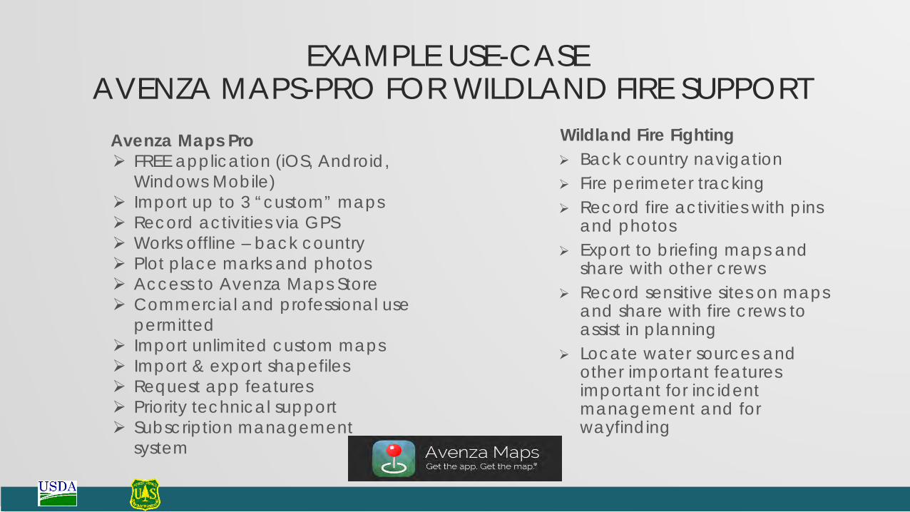
EXAMPLE USE-CASE AVENZA MAPS-PRO FOR WILDLAND FIRE SUPPORT
Avenza Maps Pro FREE application (iOS, Android,
Windows Mobile) Import up to 3 “custom” maps Record activities via GPS Works offline – back country Plot place marks and photos Access to Avenza Maps Store Commercial and professional use
permitted Import unlimited custom maps Import & export shapefiles Request app features Priority technical support Subscription management
system
Wildland Fire Fighting Back country navigation Fire perimeter tracking Record fire activities with pins
and photos Export to briefing maps and
share with other crews Record sensitive sites on maps
and share with fire crews to assist in planning
Locate water sources and other important features important for incident management and for wayfinding

EXAMPLE USE-CASE - COLLECTING DATA ABOUT RECREATION SITES USING SURVEY 123
Collecting Data for the FS Accessibility Database• Detailed accessibility information about each recreation
site/facility, individual rec unit and constructed features.• To provide accurate information to our visitors:
• What’s available in the rec. site and its’ accessibility• Need that accurate information to better manage
recreation sites, what needs repair or replacement, etc.
• Assess recreation sites and facilities• Where deficiencies:
• Transition Plan– what’s not in compliance, how and when rec. sites and facilities will be brought into compliance.
• ESRI’s Survey123 on iOS and Android tablets• Surveys operate on tablet outside FS firewall:• Surveys can be conducted by non-FS crews• 21 CSC crews – funding available- FS unit decides

EXAMPLE USE-CASE USE OF ESRI COLLECTOR IN FOREST PRODUCT
MODERNIZATIONUse of Esri Collector App
Digitally mark trees for thinning Collect data to be used in restoration
planning/analysis
Need Systems for timber harvest need to evolve Help improve local economies Make better use of technology

EXAMPLE USE-CASE USE OF ESRI COLLECTOR TO ASSESS AERIAL
FIREFIGHTING USE AND EFFECTIVENESSUse of Esri’s Collector App
Obtain a representative sample of all aircraft use
Determine what we are doing effectively and efficiently
Requires very accurate data Use this information to improve efficiencies
and effectiveness Not a retardant study but a look at what
ways we are effective application and replicate those process
Need GAO Audit of expenses Need for more cost effective firefighting Reduce risk/fatality