Ohio Department of Transportation - Railroad Industries Incorporated
Upload
truongliemCategory
view
215download
0
Bay Area to Central Valley HST Final Program EIR/EIS Response to Comments from State Agencies
U.S. Department of Transportation Federal Railroad Administration
Page 21-1
Comment Letter S001 (Jim Beall, Jr., Assembly California Legislature, September 18, 2007)

Bay Area to Central Valley HST Final Program EIR/EIS Response to Comments from State Agencies
U.S. Department of Transportation Federal Railroad Administration
Page 21-2
Response to Letter S001 (Jim Beall, Jr., Assembly California Legislature, September 18, 2007)
S001-1 The Preferred Alternative identified in this Final Program Environmental Impact Report/Environmental Impact Statement (Final Program EIR/EIS) is the Pacheco Pass Network Alternative, San Francisco and San Jose Termini.
See Standard Response 3 and Chapter 8 regarding identification of the Pacheco Pass as the Preferred Alternative.
S001-2 The California High- Speed Rail Authority (Authority) and Federal Railroad Administration (FRA) acknowledge the background information provided by Assembly Member Jim Beal, Jr.
S001-3 The Pacheco Pass Network Alternative has been identified as the Preferred Alternative in this Final Program EIR/EIS. The statements made in support of this alternative in Assembly Member Jim Beal’s letter were among the reasons for identifying the Pacheco Pass Network Alternative as the Preferred Alternative. These reasons include direct connection between northern and southern California population centers; connectivity to other transit connections; service to the Salinas and Monterey Bay area via Gilroy; transit connection plans for the Santa Clara, San Mateo, and Alameda County areas; and the need to respond to the global warming issue. During the project-level engineering and environmental review, decisions regarding the provision of parking facilities at high-speed train (HST) stations will take into account the level of existing or planned transit connectivity to that station.

Bay Area to Central Valley HST Final Program EIR/EIS Response to Comments from State Agencies
U.S. Department of Transportation Federal Railroad Administration
Page 21-3
Comment Letter S002 (Derrick J. Adachi, Department of Water Resources, August 20, 2007)

Bay Area to Central Valley HST Final Program EIR/EIS Response to Comments from State Agencies
U.S. Department of Transportation Federal Railroad Administration
Page 21-4
Response to Letter S002 (Derrick J. Adachi, Department of Water Resources, August 20, 2007)
S002-1 Comment acknowledged.
S002-2 Comment acknowledged. The Authority and FRA expect that the California Department of Water Resources will serve as a responsible agency for EIRs for individual sections of the HST system.

Bay Area to Central Valley HST Final Program EIR/EIS Response to Comments from State Agencies
U.S. Department of Transportation Federal Railroad Administration
Page 21-5
Comment Letter S003 (John Garamendi, Lieutenant Governor, August 28, 2007)

Bay Area to Central Valley HST Final Program EIR/EIS Response to Comments from State Agencies
U.S. Department of Transportation Federal Railroad Administration
Page 21-6
Response to Letter S003 (John Garamendi, Lieutenant Governor, August 28, 2007)
S003-1 In response to public requests such as this request from the Lieutenant Governor, the Authority and FRA added two additional public hearings on the Draft Program EIR/EIS: one in Stockton and one in Sacramento. The Authority Board identified service to Sacramento as part of the proposed HST system analyzed in its statewide program EIR/EIS (California High-Speed Rail Authority and Federal Railroad Administration 2005), which was certified by the Authority Board in 2005.

Bay Area to Central Valley HST Final Program EIR/EIS Response to Comments from State Agencies
U.S. Department of Transportation Federal Railroad Administration
Page 21-7
Comment Letter S004 (Brian Leahy, Department of Conservation, September 11, 2007)

Bay Area to Central Valley HST Final Program EIR/EIS Response to Comments from State Agencies
U.S. Department of Transportation Federal Railroad Administration
Page 21-8
Comment Letter S004 – Continued

Bay Area to Central Valley HST Final Program EIR/EIS Response to Comments from State Agencies
U.S. Department of Transportation Federal Railroad Administration
Page 21-9
Comment Letter S004 - Continued

Bay Area to Central Valley HST Final Program EIR/EIS Response to Comments from State Agencies
U.S. Department of Transportation Federal Railroad Administration
Page 21-10
Response to Letter S004 (Brian Leahy, Department of Conservation, September 11, 2007)
S004-1 Section 3.8, Agricultural Lands, used the Farmland Mapping and Monitoring Program and identified the farmlands potentially affected by the HST alignment alternatives and ancillary facilities. Farmland categories analyzed included prime farmland, farmland of statewide importance, unique farmland, and farmland of local importance. These farmland categories were also mapped in relation to the alignment alternatives and station location options and illustrated in Figure 3.8-2. Acreages of farmland, by category, that would potentially be converted were calculated and included in Table 3.8-1 and in Appendix 3.8-A-1. The study area was covered by Important Farmland Map boundaries.
S004-2 The federal Farmland Protection Policy Act was considered in this EIR/EIS. The Authority acknowledges the recommendation for use of the Land Evaluation and Site Assessment (LESA) Model for subsequent project-level analysis.
S004-3 The farmland analysis in Section 3.8 included alignment alternatives and ancillary facilities. Chapter 5.0 identified potential impacts, including effects on farmland as a result of potential growth near stations. At the program level, it was assumed that HST project construction impacts on farmland would generally be within the 100-foot study area identified for the long-term operational impacts.
S004-4 A list of mitigation strategies for impacts on agricultural lands is presented in Section 3.8.5 and will be further defined and applied at the project-level. As noted in this document, at the project level the Authority will coordinate application of feasible farmland mitigation measures to address all significant impacts with other mitigation initiatives, such as the California Farmland Conservancy Program
(California Public Resources Code §10222 et seq.), which is managed by the California Department of Conservation.
S004-5 The Williamson Act, as noted, is described in Section 3.8.1. Project-level environmental analysis will include mapping of Williamson Act contract lands located in the vicinity of the proposed HST system.
S004-6 The Authority and FRA acknowledge receipt of the contact information for notice regarding the location of a public improvement in an agricultural preserve, and the need to also contact the local governing body.
The Director of Conservation has been included in the distribution of this Final Program EIR/EIS and will be provided notice of potential impacts on agricultural lands, including lands in agricultural preserves and/or subject to Williamson Act contracts, which will be identified during subsequent project-level environmental review and analysis.
S004-7 Comment acknowledged. The Authority and FRA appreciate and understand the notification provisions under the Williamson Act for possible acquisition of land enrolled in a Williamson Act contract.
S004-8 Comment acknowledged. Additional relevant environmental documentation will be provided to the Division of Land Resource Protection, Department of Conservation, as such documentation becomes available.

Bay Area to Central Valley HST Final Program EIR/EIS Response to Comments from State Agencies
U.S. Department of Transportation Federal Railroad Administration
Page 21-11
Comment Letter S005 (Richard G. Rayburn, Department of Parks and Recreation, September 19, 2007 )

Bay Area to Central Valley HST Final Program EIR/EIS Response to Comments from State Agencies
U.S. Department of Transportation Federal Railroad Administration
Page 21-12
Response to Letter S005 (Richard G. Rayburn, Department of Parks and Recreation, September 19, 2007)
S005-1 In response to requests from agencies and the public, the Authority and FRA extended the public comment period for the Draft Program EIR/EIS from September 28 to October 26, 2007.

Bay Area to Central Valley HST Final Program EIR/EIS Response to Comments from State Agencies
U.S. Department of Transportation Federal Railroad Administration
Page 21-13
Comment Letter S006 (W. E., Loudermilk, Department of Fish and Game, September 25, 2007)

Bay Area to Central Valley HST Final Program EIR/EIS Response to Comments from State Agencies
U.S. Department of Transportation Federal Railroad Administration
Page 21-14
Comment Letter S006 – Continued

Bay Area to Central Valley HST Final Program EIR/EIS Response to Comments from State Agencies
U.S. Department of Transportation Federal Railroad Administration
Page 21-15
Comment Letter S006 - Continued

Bay Area to Central Valley HST Final Program EIR/EIS Response to Comments from State Agencies
U.S. Department of Transportation Federal Railroad Administration
Page 21-16
Comment Letter S006 - Continued

Bay Area to Central Valley HST Final Program EIR/EIS Response to Comments from State Agencies
U.S. Department of Transportation Federal Railroad Administration
Page 21-17
Comment Letter S006 – Continued

Bay Area to Central Valley HST Final Program EIR/EIS Response to Comments from State Agencies
U.S. Department of Transportation Federal Railroad Administration
Page 21-18
Response to Letter S006 (W. E., Loudermilk, Department of Fish and Game, September 25, 2007)
S006-1 The Authority and FRA disagree. The Program EIR/EIS provides sufficient information to make findings regarding the potential environmental impacts of various alignment alternatives and station location options and make meaningful comparisons, thus allowing for identification of a preferred alternative.
The Authority and FRA acknowledge that a large amount of additional environmental analysis will be necessary at the project level, which is fully consistent with the tiering of the environmental documents.
Figure 3.15-4 has been added to Section 3.15 to illustrate publicly owned and managed state and federal lands in relation to the alignment alternatives. Additional discussion has also been added about publicly owned and managed lands, wildlife movement, threatened and endangered species, and sensitive habitats.
See Standard Response 2 regarding program level of analysis.
S006-2 The Authority and FRA recognize the authority of the California Department of Fish and Game (CDFG) in its role as a Trustee Agency and Responsible Agency and its regulatory authority related to activities occurring in streams and/or lakes that could adversely affect any fish or wildlife resource.
S006-3 The geographic information systems (GIS) data provided by the CDFG were used for this Program EIR/EIS. Figure 3.15-4, Public Lands, has been added to Section 3.15 in this Final Program EIR/EIS, along with additional discussion on publicly owned or managed lands.
As noted in Section 2.3.2, Design Practices, use of existing transportation corridors would be maximized to avoid or minimize impacts. Use of transportation corridors includes placing HST
alignments either within or adjacent to major existing transportation corridors. In-line construction would also be used for sensitive areas (as defined at the project level). This would potentially include publicly owned or managed lands if they were identified to be sensitive. In addition to design practices for construction and operation of the HST system, mitigation strategies are discussed throughout Chapter 3 for each of the environmental topics.
As noted in Section 3.01, the Authority and FRA acknowledge that a large amount of additional environmental analysis will be necessary at the project level, which is fully consistent with the tiering of the environmental documents. Please see Standard Response 2 regarding program level of analysis. At the project level, specific impacts on wildlife, public use, and management of publicly owned and managed lands will be investigated in much greater detail. The HST may have beneficial effects in terms of adding to conservation efforts and improving the ability of residents and tourists to access wildlife areas, thereby increasing revenues and increasing the public recreational opportunities. Mitigation strategies include the Authority working with resource agencies in identifying areas for improving wildlife habitat (Section 3.15)
S006-4 As noted in Section 3.15 of this Final Program EIR/EIS, the Pacheco alignment alternative has the potential to affect the Cottonwood Creek Wildlife Area, but almost half of the crossing of this area would be in tunnel (1.1 miles, or 46%), which would substantially reduce biological impacts. The Henry Miller alignment alternatives would pass north of the San Luis Reservoir State Recreation Area and O’Neill Forebay Wildlife Area, ½ mile south of the Volta Wildlife Area, and south of the Los Banos Wildlife Area parking lot. The GEA North alignment alternative that was studied would bisect the southern portion of the China Lake Unit of the North Grasslands Wildlife Area and cross portions of the Great Valley Grasslands State Park and the San Luis National Wildlife Refuge.

Bay Area to Central Valley HST Final Program EIR/EIS Response to Comments from State Agencies
U.S. Department of Transportation Federal Railroad Administration
Page 21-19
The Authority and FRA intend that the HST system be designed to avoid direct impacts on the Los Banos Wildlife Area and expect conditions requiring this to be included in future action on the Final EIR/EIS and the approval of a preferred alternative. This would include required investigation into site-specific location and design alternatives for the preferred alignment alternative and station location options, including avoidance and minimization alternatives, during the Tier 2 project-level environmental review. This would also include evaluating design alternatives to the north and south of the current proposed alignment across the Pacheco Pass and along Henry Miller Road. See also Section 3.15.5 regarding the Authority’s commitment to acquire agricultural, conservation, and/or open space easements for potential impacts in and around the GEA.
The Preferred Alternative generally follows the Henry Miller Road and would not enter into areas where hunting is allowed. The same precautions that hunters must exercise around a public transportation corridor would also be necessary for the train. Therefore, significant impacts on hunting are not anticipated. The potential for impacts on fishing would be limited to those potential impacts identified for water quality.
Potential impacts on resources protected by Section 4(f) of the U.S. Department of Transportation Act of 1966 are discussed in Section 3.16.
Program-level HST design and operation details are discussed in Chapter 2, Alternatives, along with design practices to avoid, minimize, and mitigate potential impacts. Additionally, plans and profiles, cross sections, and station fact sheets are provided in Appendices 2-D, 2-F, and 2-E.
Please also see Standard Response 3 and Chapter 8 regarding the identification of the Pacheco Pass as the Preferred Alternative.
S006-5 The Authority and FRA disagree that the Draft Program EIR/EIS underestimates the projects impacts on biological resources and wetlands. The program-level approach tends to overestimate the potential impacts on these resources.
The GEA is described in Section 3.15.2. It is a nonjurisdictional, nonregulatory, generally designated area used by the U. S. Fish and Wildlife Service (USFWS) to identify an area for priority purchase of public easements for wetland preservation and enhancement. The GEA designation encompasses a substantial area that includes two federal wildlife refuges, a state park, state wildlife management areas, and private lands, including privately managed wetlands. Lands in the GEA managed by public agencies include the Great Valley Grasslands State Park; CDFG North Grasslands Wildlife Area, Los Banos Wildlife Area, and Volta Wildlife Area; and the San Luis National Wildlife Refuge Complex, which includes the San Luis National Wildlife Refuge and Merced National Wildlife Refuge. Also in the GEA are numerous privately owned parcels and a number of waterfowl hunting clubs. Activities and land uses in the GEA include hunting, fishing and other active and passive recreation, agriculture, and residential and associated land uses.
Within the area identified as the GEA is the USFWS Grasslands Wildlife Management Area (WMA), which was established to protect wetlands. Land in the WMA is privately owned and some of it is protected by conservation easements. The size of this management area as of the last expansion in 2005 is approximately 133,000 acres, with more than 70,000 acres protected through conservation agreements. Daily management of the easement area remains under private landowner control, the majority of the properties being managed for waterfowl hunting, cattle grazing, and agriculture.
The Draft Program EIR/EIS recognized the importance of the GEA (including the San Luis National Wildlife Refuge Complex and other managed lands in the GEA). The Draft Program EIR/EIS analyzed the potential environmental impacts, including impacts on wetlands, of the HST alignment alternatives and station location options, regardless of land designation. Impacts on resources inside and outside the boundary of the GEA were analyzed and documented in the Draft and Final Program EIR/EIS.
The Henry Miller alignment alternative would extend through two southern portions of the GEA and would be immediately adjacent to

Bay Area to Central Valley HST Final Program EIR/EIS Response to Comments from State Agencies
U.S. Department of Transportation Federal Railroad Administration
Page 21-20
the roadway where it crosses areas now managed by public agencies. This alignment alternative would be adjacent to Henry Miller Road and would avoid or minimize potential impacts on biological resources. The western portion of the GEA crossed by the alignment alternative closest to Los Banos would extend adjacent to Henry Miller Road and the San Luis Wasteway and cross Ingomar Road ½ mile south of the Volta Wildlife Area. This area of the GEA is already bisected by transportation and infrastructure facilities, including rail and roadways, and also includes housing development, farm operations, land under active agricultural production, and may include land under conservation easements. The other area of the GEA crossed by the alignment is south of the Los Banos Wildlife Area parking lot. As shown in the current conceptual plans, the alignment alternative would extend approximately 3.3 miles on elevated structure through the GEA boundary along Henry Miller Road, minimizing effects on waters and biological resources. This area of the GEA is bisected by Henry Miller Road, State Route (SR) 165, Baker Road, Delta Road, Santa Fe Grade, Criswell Avenue, and a number of canals and also includes housing development, farm operations, and land under active agricultural production.
The Henry Miller alignment alternative would not further fragment the linkage between the north and south units of the Grasslands WMA because the alignment is adjacent to Henry Miller Road, an existing facility, and would be elevated for almost half the distance through the GEA. Both the general area designation of the GEA and the establishment of the Grasslands WMA occurred well after roads, utilities, farms, and residences were already established, and the Henry Miller alignment alternative would not result in additional fragmentation. As noted above, the boundaries for the GEA and the WMA may change. Expanding the WMA does not mean that all properties within it are, or would be, under conservation easements. An environmental assessment prepared in 2005 by the USFWS supported its decision to expand the general area by an additional 46,400 acres. The USFWS and other agencies may seek to acquire easements, lands, or interests in lands from willing sellers, as funds allow, but landowners are not required to participate, and the 2005
review by the USFWS did not place regulatory restrictions on these lands. 1 2
The environmental analysis was conducted at a program level and identified the need for field reconnaissance-level surveys to be conducted in the future at the project level. These future surveys will determine specific habitat conditions and impacts along the Henry Miller alignment alternative, the entire Preferred Alternative, and surrounding areas and will identify specifically where impacts on wetlands, sensitive habitat, and special-status species could occur and where focused species surveys are required. The Henry Miller alignment alternative and other alignment alternatives using the Pacheco Pass will be further designed at the project level to avoid or minimize potential impacts. Broad program mitigation measures have been identified and will be further refined and applied at the project level to mitigate impacts. Please see Standard Response 5 regarding mitigation strategies. See also Section 3.15.5 regarding the Authority’s commitment to acquire agricultural, conservation, and/or open space easements for potential impacts in and around the GEA. The Authority and FRA will continue coordination with all agencies and organizations involved to identify specific issues and develop solutions that avoid, minimize, and mitigate potential biological impacts.
The discussion in Section 3.15 has been revised to indicate that the Henry Miller alignment alternatives would not affect the San Luis National Wildlife Refuge (including the Kesterson unit) in the GEA.
The text on page 3.16-11 in the Draft Program EIR/EIS indicates that the GEA is within 0–150 ft of the Henry Miller alignment alternative. Areas within the GEA that constitute 4(f) or Section 6(f) resources, including the San Luis and Merced National Wildlife Refuges, a state park, and CDFG wildlife areas, are discussed in Section 3.16. 1 Grasslands Wildlife Management Area Proposed Expansion EA, Land Protection
Plan, and Conceptual Management Plan, USFWS, January 2005. 2 Grasslands Wildlife Management Area Expansion Study, Planning Update 5, July
2005. USFWS, July 2005.

Bay Area to Central Valley HST Final Program EIR/EIS Response to Comments from State Agencies
U.S. Department of Transportation Federal Railroad Administration
Page 21-21
S006-6 Section 3.15 has been updated with regard to the California tiger salamander and the GEA North alignment alternative.
S006-7 Refer to Response to Comments S006-5 and F002-10 regarding wildlife movement. Design practices incorporated into the project include underpasses, overpasses, or other appropriate passageways that would be designed to avoid, minimize, and/or mitigate potential impacts on wildlife movement. Mitigation strategies to minimize impacts on sensitive species and habitat and wildlife movement corridors are included in the Program EIR/EIS. These include the following:
• Construct wildlife underpasses, bridges, and/or large culverts to facilitate known wildlife movement corridors.
• Ensure that wildlife crossings are of a design, shape, and size to be sufficiently attractive to encourage wildlife use.
• Provide appropriate vegetation to wildlife overcrossings and undercrossings to afford cover and other species requirements.
• Establish functional corridors to provide connectivity to protected land zoned for uses that provide wildlife permeability.
• Design protective measures for wildlife movement corridors in consultation with resource agencies.
• Use aerial structures or tunnels to allow for unhindered crossing by wildlife.
Also, refer to Response to Comment S006-1 and Standard Response 2 regarding analysis at the program level.
S006-8 The Authority and FRA disagree. The Draft Program EIR/EIS depicted broad corridors; however, to clarify we are providing additional information. Figure 3.15-3 has been updated to include additional wildlife movement corridors as noted. The text has also been updated with these corridors. Also refer to Response to
Comments S006-7, S006-5, and F002-10 regarding wildlife movement.
S006-9 The cross valley corridor is included in Figure 3.15-3 in the Draft Program EIR/EIS. It is corridor #7, Santa Cruz Mountains-Hamilton Mountain.
S006-10 The Preferred Alternative identified in this Final Program EIR/EIS is the Pacheco Pass, San Francisco and San Jose Termini, which includes the Henry Miller alignment alternative and would not include the GEA North alignment alternative. The Authority and FRA have committed to investigating site-specific location and design alternatives for the preferred alignment alternative and station location options, including avoidance and minimization alternatives, during Tier 2, project-level environmental review. This will include evaluating design alternatives to the north and south of the current proposed alignment along Henry Miller Road. See also Section 3.15.5 regarding the Authority’s commitment to acquire agricultural, conservation, and/or open space easements for potential impacts in and around the GEA. Please also see Standard Response 3 and Chapter 8 regarding the identification of the Pacheco Pass at the Preferred Alternative.
Refer to Responses to Comments F002-6 regarding conservation measures and F002-10 regarding kit fox issues of the Henry Miller alignment alternative.
The GEA North alignment alternative occurs approximately 6 miles north of the pinch-point at the base of the San Luis Dam. Kit fox moving north would be most likely to encounter the HST alignment west of the Delta-Mendota Canal and east of the proposed tunnel entry point at the base of the Diablo Range hills. Because of this distance, the HST would not further narrow or limit the movement options available for kit fox traversing around the San Luis Reservoir or O’Neill Forebay. Refer to Response to Comment F006-10 regarding measures to mitigate impacts on wildlife movement

Bay Area to Central Valley HST Final Program EIR/EIS Response to Comments from State Agencies
U.S. Department of Transportation Federal Railroad Administration
Page 21-22
corridors. The Authority, a state agency, and the FRA will work with the CDFG to conserve endangered species and threatened species as stated in Fish and Game Code Section 2055.
At the project-level, the Authority and FRA will be examining in detail the potential for the selected alignment to affect land protected in perpetuity. The project-level analysis will identify other opportunities to avoid or minimize potential impacts.
S006-11 As noted in Section 2.3.2, Design Practices, use of existing transportation corridors would be maximized to avoid or minimize impacts, such as barriers to wildlife movement. Use of transportation corridors includes placing HST alignments either within or adjacent to a major existing transportation corridor. In addition, HST tracks will be fully grade separated from all roadways, providing other opportunities for wildlife movement corridors. The Authority and FRA are committed to working with CDFG and USFWS and other resource agencies in identifying locations, such as in western Merced County, along the HST alignments for wildlife passages, including overpasses or underpasses. Please see Response to Comment S006-7 and Standard Response 5 regarding mitigation strategies. An elevated structure is included through part of the alignment, but to do this throughout the system would be cost prohibitive and would not appear to be a feasible mitigation.
S006-12 Sufficient information is available to support identification of the Preferred Alternative in this Final Program EIR/EIS. Please see Standard Response 1 regarding decision making at the program level. Future project-level environmental surveys and analyses will be coordinated with detailed engineering to further refine the HST alignment and profile so that location, numbers, size, and types of wildlife movement passages can be determined and cost estimates created. The Authority will take into consideration and apply where appropriate, the methods identified for determining the best locations for wildlife movement structures and for identifying wildlife
linkages when conducting the Tier 2 phase of environmental studies on the approved alignment alternative.
S006-13 The scale of potential impacts from the HST system is not unprecedented and is substantially less than the construction of highways and airports to provide equivalent mobility (see the statewide program EIR/EIS). The construction costs for the network alternatives included mitigation costs, including those for wildlife movement structures, as well as contingency costs. Costs are discussed in Chapter 4, “Costs and Operations.”
S006-14 Comment acknowledged. Wildlife movement issues and mitigation also address the movement needs of other species, such as red-legged frog, tiger salamander, and nonlisted special-status species, such as American badger.
S006-15 Detailed noise and vibration studies as they relate to biological resources will be required and conducted as part of the Tier 2 project-level environmental analysis, following more detailed biological surveys to determine the presence of and effects on specific species.
The FRA 100 dBA sound threshold for impacts on wildlife is a source reference level. The 100 dBA is referenced as a sound exposure level (SEL), which is the level of sound accumulated over a given time interval or event. The SEL is the level of the time-integrated mean square A-weighted sound over a 1-second time period. When it is converted to represent noise sources over longer periods of time, the level is adjusted lower to reflect the distribution of the sound energy over that period. At speeds of 220 miles per hour (mph) the distance of estimated impact extends to 200 ft from the centerline of the alignment.
The potential for direct effects of train noise on wildlife in natural areas is not well documented. There are large gaps in the existing

Bay Area to Central Valley HST Final Program EIR/EIS Response to Comments from State Agencies
U.S. Department of Transportation Federal Railroad Administration
Page 21-23
knowledge of the impact of noise on wildlife populations. In invertebrates and lower vertebrates (fish, reptiles, amphibians), there is relatively little study on the effects of transportation noise, with no clear indication of a strong adverse response. For reptiles and amphibians, effects appear to be localized and likely due to mortality or a barrier to movement. Recent studies on the effects of traffic noise on toads in burrows near roads strongly indicate that further study on this or similar behaviors is warranted. For birds, noise can apparently have a significant effect; however, the results are not universal, with some species being adversely affected, many unaffected, and still others becoming more common near even interstate highways. Mammals (particularly large species) may avoid noise; however, there is evidence (particularly for smaller species) that additional habitat and corridors for movement are provided by roadways.
Current research suggests that the noise effects of trains traveling at very high speed could have limited influence on some species close to the tracks. Some research has been performed regarding the reactions of animals to low-flying aircraft, but the specific levels of significance and specific effects related to high-speed trains are not known. Long-term changes in behavior tend to be strongly influenced by factors other than intermittent noise exposure (as would occur with HSTs), such as weather, predation, disease, and other disturbances to animal populations. Conclusions from research conducted to date provide only preliminary indications of the appropriate noise descriptor, rough estimates of threshold levels for observed animal disturbance, and habituation characteristics of only a few species. Long-term effects continue to be a matter of speculation. Because HSTs always will be on the same track and on a schedule, habituation may be likely to occur. Sound levels from train passes are also not as high, nor are onset rates as great, as they are from low-altitude military aircraft, hence, the observed effects of aircraft may not apply to HSTs.
Mitigation measures for natural areas would be considered at the project level, including relevant information, if any, from countries with HSTs. While other HST systems in Europe and Japan have implemented noise mitigation for human receptors, mitigation is not
known to have been provided for wildlife, to date. Extensive use of sound walls in rural areas would be impractical. Alternatives to noise barriers in these locations, such as trenches or earth berms, could be explored during project-level environmental review; however, they may also be impractical due to cost and other impacts related to the extent of land required as well as the associated construction impacts. The TGV in France has several locations where topography facilitated the use of fairly deep trenches and earth berms that mitigate noise impacts on sensitive human receptors.
The potential noise impacts on wildlife will be studied in more detail in the second tier project-level environmental assessment to be prepared for the Preferred Alternative, if it is advanced. Two important points that will be considered as part of these more detailed studies to assess the potential impact of HSTs on wildlife are 1) the density of a given species is not necessarily an absolute indicator of the best habitat (i.e., sometimes individuals are relegated in significant numbers to less desirable habitat because of territoriality by dominant individuals) and 2) greater behavioral response (i.e., movement away from transportation noise sources) does not necessarily indicate species that are at greatest need of protection. Therefore, as part of the project-level environmental analyses potential noise impacts on wildlife will consider the quality of the habitat and the sensitivity of the population or community under consideration, as well as the degree of the noise effect on a given species.
The Authority has developed project-level environmental analysis methodologies. The purpose of these methodologies is to establish the technical approach and to guide the Authority’s contractors in performing parallel analyses for multiple sections of the HST system for each of the environmental topics, as project environmental documents are prepared. The comments received and issues raised on the Tier 1 program-level environmental documents have also been considered for these methodologies. The noise and vibration methodology will include a more detailed assessment of wildlife. Significance noise criteria will be developed in coordination with the

Bay Area to Central Valley HST Final Program EIR/EIS Response to Comments from State Agencies
U.S. Department of Transportation Federal Railroad Administration
Page 21-24
USFWS and CDFG that provide impact thresholds to the wildlife species that may be affected by the HST alignments. 3
S006-16 As noted in the Draft Program EIR/EIS, the Authority and FRA find the alignment along Henry Miller Road compatible with adjacent land use. This alignment places a transportation facility next to a transportation facility. The primary land use along Henry Miller Road is agriculture or agricultural-related uses. Please see Response to Comment S006-5 regarding the GEA.
East of Gilroy, the alignment again principally adjoins a roadway—SR 152—and major portions of the alignment over Pacheco Pass are in tunnel. The alignment crosses to the north side of SR 152 one mile west of Dinosaur Point Road and extends through the CDFG Upper Cottonwood Creek Wildlife Area and The Nature Conservancy Mt. Hamilton Project area, primarily in tunnel. The Henry Miller alignment alternative would cross over kit fox corridors along the Delta Mendota Canal and the San Luis Wasteway referred to in Figure 6 of the 2004 H.T. Harvey & Associates report prepared for the USFWS titled Environmental Assessment for the Issuance of an Incidental Take Permit for the San Joaquin Kit Fox at the Arnaudo Brothers, Wathen-Catanos and River East Holding Sites Within and
3 Foppen, R. and R. Reijnen. 1994. The effects of car traffic on breeding
bird populations in woodland. Breeding dispersal of male willow warblers in relation to the proximity of a highway. Journal of Applied Ecology 31:95–101.
Forman, R.T.T. and Lee Alexander. 1998. Roads and their ecological effects. Annual Review of Ecology and Systematics 29:207–231.
Forman, R.T.T., D. Sperling, J.A. Bissonette, A.P. Clevenger, C.D. Cutshall, V.H. Dale, L. Fahrig, R. France, C.R. Goldman, K. Heanue, J.A. Jones, F.J. Swanson, T. Turrentine and T.C. Winter. 2003. Road Ecology; Science and Solutions. 481pp. Island Press: Washington D.C.
Kalseloo, P.A. and K.O. Tyson. 2004. Synthesis of Noise Effects on Wildlife Populations. Report No. FHWA‐HEP‐06‐016. 67pp. Office of Research and Technology Services Federal Highway Administration.
Adjacent to, The Santa Nella Community Specific Plan Area, Merced County, California4. Specific conservation easements and mitigation sites will be further identified and, if possible, avoided as part of future Tier 2 detailed project-level environmental analysis and preliminary engineering.
The GEA North alignment alternative is not identified in this Final Program EIR/EIS as the Preferred Alternative. Please see Standard Response 3 and Chapter 8 regarding the identification of the Preferred Alternative.
S006-17 The use of the California Natural Diversity Database (CNDDB) and the landscape-level vegetation analyses were the appropriate techniques for this program-level environmental document and were considered along with contextual information to avoid the type of hypothetical example suggested in the comment. The types of analyses described by CDFG in this comment would be appropriate for the project-level analyses, once specific alignment and station locations have been identified. As noted in Section 2.3.2, Design Practices, use of existing transportation corridors would be maximized to avoid or minimize impacts. Use of transportation corridors includes placing HST alignments either within or adjacent to major existing transportation corridors that are already disturbed.
Future project-level environmental surveys and analyses will be coordinated with detailed engineering to further refine the HST alignments and station locations and avoid or minimize impacts to the greatest extent practicable. Field reconnaissance-level surveys are warranted in the Tier 2, project-level analysis to determine existing habitat conditions along the various project alignments and in surrounding areas.
4 H. T. Harvey & Associates and Ebbin Moser & Skaggs. 2004. Environmental Assessment for the Issuance of an Incidental Take Permit for the San Joaquin Kit Fox at the Arnaudo Brothers, Wathen‐Catanos and River East Holding Sites Within and Adjacent to, The Santa Nella Community Specific Plan Area, Merced County, California. July. Prepared for U.S. Fish and Wildlife Service.

Bay Area to Central Valley HST Final Program EIR/EIS Response to Comments from State Agencies
U.S. Department of Transportation Federal Railroad Administration
Page 21-25
S006-18 Refer to Standard Response 3 and Chapter 8 regarding identification of Pacheco Pass as the Preferred Alternative and Response to Comments S006-18 and S006-4.
S006-19 CDFG comments are responded to in Response to Comments S006-1 through S006-18.
S006-20 Comment acknowledged.

Bay Area to Central Valley HST Final Program EIR/EIS Response to Comments from State Agencies
U.S. Department of Transportation Federal Railroad Administration
Page 21-26
Comment Letter S007 (Elaine Alquist, et al., California Legislature, September 26, 2007)

Bay Area to Central Valley HST Final Program EIR/EIS Response to Comments from State Agencies
U.S. Department of Transportation Federal Railroad Administration
Page 21-27
Response to Letter S007 (Elaine Alquist, et al., California Legislature, September 26, 2007)
S007-1 The Pacheco Pass Alternative has been identified as the Preferred Alternative in this Final Program EIR/EIS. The statements made in support of this alternative in Senator Alquist’s and Senator Maldonado’s letter were among the reasons that the Pacheco Pass was identified as preferred, namely that there would be better levels of service (train frequencies) to the major urban areas and there would not be adverse impacts on the San Francisco Bay (including the Palo Alto shore) or the Don Edwards Wildlife Refuge.
See Standard Response 3 and Chapter 8 regarding identification of Pacheco Pass as the Preferred Alternative.
Bay Area to Central Valley HST Final Program EIR/EIS Response to Comments from State Agencies
U.S. Department of Transportation Federal Railroad Administration
Page 21-28
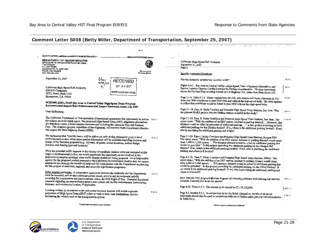
Comment Letter S008 (Betty Miller, Department of Transportation, September 25, 2007)

Bay Area to Central Valley HST Final Program EIR/EIS Response to Comments from State Agencies
U.S. Department of Transportation Federal Railroad Administration
Page 21-29
Comment Letter S008 - Continued

Bay Area to Central Valley HST Final Program EIR/EIS Response to Comments from State Agencies
U.S. Department of Transportation Federal Railroad Administration
Page 21-30
Response to Letter S008 (Betty Miller, Department of Transportation, September 25, 2007)
S008-1 The Authority and FRA appreciate the California Department of Transportation comments on the Draft Program EIR/EIS and acknowledge that the alignments under consideration would traverse three of the department’s districts and affect portions of the state highway system.
S008-2 The project-level environmental review, which will follow the completion of this program-level review, will include preliminary engineering for HST alignments and stations selected at the program level and will therefore provide more specific information (e.g., alignment profile, alignment access locations, station design features, fencing type), as noted in the letter.
The Authority and FRA will involve the State Department of Transportation in the project-level scoping meetings, in recognition that the department is a Responsible Agency under the California Environmental Quality Act (CEQA). The Authority and FRA fully agree that early and full consultation with the department at this stage will be highly beneficial.
S008-3 The Authority and FRA understand the need and requirements for an encroachment permit prior to any development activity.
S008-4 The Authority and FRA agree that locating HST stations in downtown/central business districts offers multiple benefits, including increased pedestrian access to the stations and decreased vehicle loads on the street and highway system. The majority of the HST stations for the Preferred Alternative identified in this Final Program EIR/EIS are located in downtown locations. Please see Standard Response 3 and Chapter 8.
S008-5 Please refer to the description of high-speed train technology in Section 2.3.2. Figures 2.3-6, 2.3-7, and 2.3-8 show typical sections for at-grade, aerial, and tunnel configurations. Additional typical sections are presented in Appendix 2-E (the corridor needs vary depending topography, station area, etc.). At this conceptual level of detail, for the at-grade configuration, the typical HST right-of-way (corridor width) is shown as 100 ft; however, in very constrained areas it is assumed that no more than 50 ft would be needed.
Section 3.8 of the Authority’s Engineering Criteria (California High-Speed Rail Authority and Federal Railroad Administration 2004) gave the following guidelines for the right-of-way for the system.
The minimum right-of-way limits for typical operating sections of the high-speed train system are shown in Table 3.8-1. These limits represent the minimum right-of-way required for basic implementation of a specific operating section. In many cases additional requirements apply which are also noted in the table. Other factors such as topography, soils, groundwater levels, noise receptors, cut-and-fill slopes, drainage, retaining walls, service roads, utilities, operating speeds, and construction methods also influence the extent of the required right-of-way envelope. Typical cross-sections for each general mainline section are included in Appendix A.
For the definition of alignment options, three general parameters should be followed as guidelines with consideration given to constraint information identified in the screening evaluation: (1) a minimum right-of-way corridor of 50 ft (15.2 meters) should be assumed in congested corridors; (2) a 100-foot (30.4-meter) corridor should be assumed in less developed areas to allow for drainage, future expansion and maintenance needs; and (3) a wider corridor should be assumed in variable terrain to allow for cut and fill slopes and twin-bore tunnel. In these wider sections, the width should be determined according to the minimum cross sectional requirements, as defined in Table 3.8-1, and the general assumption of 2:1 cut and fill slopes. For shared use corridors, widths would vary depending on the number of tracks required.

Bay Area to Central Valley HST Final Program EIR/EIS Response to Comments from State Agencies
U.S. Department of Transportation Federal Railroad Administration
Page 21-31
Table 3.8-1 Minimum Permanent Right-of-Way Requirements
Type of Section
Minimum Width Minimum Requirements
At-Grade/Cut-and-Fill/ Retained Fill
50 ft (15.2 m)
Fee purchase of entire width Cut & Fill section requires additional width to accommodate drainage and 2:1 slopes
Aerial Structure
50 ft (15.2 m)
Fee purchase required for column foundations Fee purchase or aerial easement required for full width of structure plus 3.5 ft (1 m) on each side for maintenance purposes. Allows for ongoing use of land area under the structure (parking, streets, other rail services, etc.) with appropriate lease for private entities or agreement with public entities. This arrangement must allow for ongoing access to columns for maintenance and proper protection for columns if area is used for street or rail purposes.
Tunnel (Double Track)
67 ft (20.4 m)
Fee purchase or underground easement of entire width. Fee purchase allows for ongoing use of land area above the structure (parking, streets, open space, etc.) with appropriate lease for private entities or agreement with public entities.
Tunnel (Twin Single Track)
120 ft (36.6 m)
Fee purchase or underground easement of entire width. Fee purchase allows for ongoing use of land area above the structure (parking, streets, open space, etc.) with appropriate lease for private entities or agreement with public entities.
Trench Section (open or closed)
50 ft (15.2 m)
Fee purchase of entire width Closed section allows for ongoing use of land area over the structure (parking, streets, open areas, etc.) with appropriate lease for private entities or agreement with public entities.
Note: Widths do not include temporary easements required for construction purposes.
S008-6 As noted in the legend of Figure S.4-1, the tan labels are alignment designations. The limits of the Pacheco Pass alignment alternative are defined as between San Jose and the split (just west of Interstate 5 [I-5]) between the GEA North and Henry Miller alignment alternatives. The western portion of the Pacheco Pass alignment alternative is along the Caltrain Corridor, which runs generally parallel to US-101. The remaining portion of this alignment is along SR 152.
S008-7 The lower volume-to-capacity in 2030 is the result of comparing regional forecasts with existing volumes that were heavily influenced by the peak of the DOTCOM boom. In reality, the future volumes would probably be higher than for existing conditions. The primary comparison, however, was intended to be the effect of a Palo Alto Station with and without HST. Because of additional automobile trips to access the Palo Alto HST station, local traffic conditions around the station would be worse with HST than without. The traffic reduction benefits of HST would occur on intercity freeways, not on local streets. All station areas would experience some increase in traffic with the HST system.
S008-8 The planned Bay Area Rapid Transit (BART) extension to San Jose (Diridon Station) and Santa Clara, which is included in the MTC Resolution 3434, was considered in this study. However, it was not included in the No Project Alternative because it is not contained in the fiscally constrained RTP.
The BART station at San Jose was not included in this analysis because it was not included as a No-Build project. At the Warm Springs site, the future BART station was mentioned but not included in the traffic analysis.
S008-9 To mitigate parking impacts on neighborhoods surrounding HST stations, the analysis estimated added parking demand and included

Bay Area to Central Valley HST Final Program EIR/EIS Response to Comments from State Agencies
U.S. Department of Transportation Federal Railroad Administration
Page 21-32
in the HST system additional parking facilities at a conceptual level to meet this parking demand. Appendix 2F provides station fact sheets and concept plans for the various stations. The included number of parking spaces is provided on the station fact sheets, and the included parking locations are shown on the station plans. (Note that additional parking is not assumed for such major urban centers as the San Francisco Transbay Transit Center, which is well served by transit, pedestrian access, and taxis.) The preliminary locations of the additional HST parking for the Diridon and Gilroy stations are shown in Figures 2F-34 and 2F-40, respectively. The Morgan Hill station is not proposed as part of the Preferred Alternative identified in this Final Program EIR/EIS. Please see Standard Response 3 and Chapter 8.
S008-10 The design of specific grade separations will be more fully defined during the project-level EIR/EIS and preliminary engineering. It is anticipated that a portion of the grade separations developed for HST tracks that are adjacent to freight tracks will involve separation not only of the HST system but also the freight tracks, depending on the specific site conditions and the cooperation and agreement of the freight track owner. At times, street closures at the rail right-of-way will also be proposed.
S008-11 Change has been made in the document.
S008-12 Change has been made in the document.
S008-13 The Authority and FRA acknowledge receipt of the contact information.

Bay Area to Central Valley HST Final Program EIR/EIS Response to Comments from State Agencies
U.S. Department of Transportation Federal Railroad Administration
Page 21-33
Comment Letter S009 (Richard Rayburn, Department of Parks and Recreation, October 26, 2007)

Bay Area to Central Valley HST Final Program EIR/EIS Response to Comments from State Agencies
U.S. Department of Transportation Federal Railroad Administration
Page 21-34
Comment Letter S009 – Continued

Bay Area to Central Valley HST Final Program EIR/EIS Response to Comments from State Agencies
U.S. Department of Transportation Federal Railroad Administration
Page 21-35
Comment Letter S009 – Continued

Bay Area to Central Valley HST Final Program EIR/EIS Response to Comments from State Agencies
U.S. Department of Transportation Federal Railroad Administration
Page 21-36
Comment Letter S009 – Continued

Bay Area to Central Valley HST Final Program EIR/EIS Response to Comments from State Agencies
U.S. Department of Transportation Federal Railroad Administration
Page 21-37
Comment Letter S009 – Continued

Bay Area to Central Valley HST Final Program EIR/EIS Response to Comments from State Agencies
U.S. Department of Transportation Federal Railroad Administration
Page 21-38
Comment Letter S009 – Continued

Bay Area to Central Valley HST Final Program EIR/EIS Response to Comments from State Agencies
U.S. Department of Transportation Federal Railroad Administration
Page 21-39
Comment Letter S009 – Continued

Bay Area to Central Valley HST Final Program EIR/EIS Response to Comments from State Agencies
U.S. Department of Transportation Federal Railroad Administration
Page 21-40
Response to Letter S009 (Richard Rayburn, Department of Parks and Recreation, October 26, 2007)
S009-1 The Authority and FRA acknowledge that the Department of Parks and Recreation would have preferred an extension of the public review time beyond the 30-day extension that was provided in response to earlier requests from the department and others.
S009-2 The Authority and FRA acknowledge the roles and mission of the Department of Parks and Recreation.
S009-3 The proposed project would not affect the entrance to Henry Coe State Park or the Dowdy Ranch Visitor Center. The alignment would be south of SR 152 near the entrance to Henry Coe and Dowdy Ranch Visitor Center.
The Authority and FRA have been committed to using existing transportation corridors and rail lines in the proposed HST system to minimize potential impacts on California’s treasured landscape. A key Authority and FRA objective continues to be avoidance and/or minimization of potential impacts on cultural, park, recreational, and natural resources and wildlife refuges.
The development of HST alignment alternatives and station location options for the Draft Program EIR/EIS included an extensive screening analysis in which many alignment and station options were eliminated from further consideration due to several criteria, including high potential for impacts on park and recreational resources. Avoidance of potential impacts on park and recreational resources was a consideration throughout the preparation of the Draft Program EIR/EIS and the recent public process to identify preferred alignments for the proposed system that has been included in this Final Program EIR/EIS. For instance, the Authority and FRA eliminated from further consideration two potential HST alignments crossing through Henry Coe State Park. The prior alignment through Henry Coe State Park was dropped from
consideration in part due to comments from the Department of Parks and Recreation on the statewide program EIR/EIS. Future project-level environmental review will provide further opportunities to avoid and minimize the potential effects on parks, as more specific alignments and facilities are considered.
The Draft Program EIR/EIS reviewed at a program level the potential impacts of all of the HST alignment alternatives and station location options for both the Altamont and Pacheco Pass alternatives on the natural, cultural, and scenic resources for reasonable alternatives. The preliminary engineering and project-level environmental review will evaluate these potential impacts in more detail (e.g., potential impacts on Pacheco State Park, San Luis Reservoir State Recreation Area, George J. Hatfield State Recreation Area, Great Valley Grasslands State Park and the Martial Cottle Property, as well as the Bell Station entrance to Henry Coe State Park).
See Standard Response 2 regarding program level of analysis.
S009-4 Please see Response to Comment S009-3 regarding parks.
S009-5 Please see Response to Comment S009-3 regarding parks
S009-6 Comment noted. This Final Program EIS/FEIR includes a discussion of global climate change (Section 3.3, Air Quality, and 3.17, Cumulative Impacts).
S009-7 Please see Standard Response 3, Chapter 8, and Response to Comment S009-8 regarding the identification of Pacheco Pass as the Preferred Alternative.

Bay Area to Central Valley HST Final Program EIR/EIS Response to Comments from State Agencies
U.S. Department of Transportation Federal Railroad Administration
Page 21-41
S009-8 The Authority and FRA disagree with the commenter that the reasonable alternatives evaluated in the Draft Program EIR/EIS have potential to impact Henry Coe State Park and find the information and analysis in the Draft Program EIR/EIS, coupled with the extensive public comment on the Draft Program EIR/EIS, sufficient to identify the Pacheco Pass Alternative as the Preferred Alternative.
The Authority and FRA appreciate and respect the Department of Parks and Recreation statement favoring the Altamont route as the preferred alternative. Numerous others have offered a similar view, as shown in this volume of the Final Program EIR/EIS. The Authority and FRA have, however, identified the Pacheco Pass Network Alternative as the Preferred Alternative in this Final Program EIR/EIS, and this position is also supported by many, again as evidenced by the public comments in this volume of the Final Program EIR/EIS.
See Standard Response 3 and Chapter 8 regarding identification of Pacheco Pass as the Preferred Alternative.
S009-9 Section 3.15 acknowledges that there are protected lands of high biological value that should be avoided in the Mt. Hamilton area. The Authority and FRA disagree with the commenter’s broad characterization that the area the Pacheco Pass alignment alternatives run through is relatively pristine. The potential impacts of the Pacheco Pass alignment alternative between Morgan Hill and the Central Valley were evaluated at the program level for impacts on biological resources and publicly owned lands, including those local, state, and federal resources, such as Henry W. Coe State Park and Pacheco State Park, which are within or near the Mt. Hamilton Project area identified for private conservation efforts by The Nature Conservancy and others. The program EIR/EIS acknowledged the potential for significant impacts on Mt. Hamilton Project area lands. There would be no impacts on Henry Coe State Park or Pacheco State Park. The Authority and FRA looked at the consequences of the project on those resources in that area (Section 3.15.3).
As noted in Section 2.3.2, Design Practices, use of existing transportation corridors would be maximized to avoid or minimize impacts, such as fragmentation or barriers to wildlife movement. Use of transportation corridors includes placing HST alignments either within or adjacent to major existing transportation corridors such as the existing rail corridor between Morgan Hill and Gilroy, SR 152, and Henry Miller Road. As shown on the current conceptual plans, more than 9 miles, about 41% of the 22 miles, of tunnel have been identified for the segment crossing between Morgan Hill and the San Luis Reservoir, and a portion of the alignment along Henry Miller Road (approximately 3 miles) would be on an aerial structure. HST tracks will be fully grade separated from all roadways, providing opportunities for wildlife movement corridors. See also Section 3.15.5 regarding the Authority’s commitment to acquire agricultural, conservation, and/or open space easements for potential impacts in and around the GEA. The Authority and FRA are committed to working with CDFG and USFWS and other resource agencies in identifying locations, such as through the Mt. Hamilton Project area, along the HST alignments for wildlife passages, including overpasses or underpasses. Refer to Standard Response 5 and Response to Comment S006-7 regarding mitigation strategies.
Refer to Standard Response 3 and Chapter 8 regarding identification of Pacheco Pass as the Preferred Alternative. In addition to potential impacts on the Don Edwards San Francisco Bay National Wildlife Refuge, these Altamont network alternatives would also have potential impacts on other local and regional Bay Area parks and recreation areas.
S009-10 Although biological resource impacts were acknowledged in the Draft Program EIR/EIS, the Authority and FRA disagree that the introduction of an HST rail line as planned and considered in this Program EIR/EIS would present an unmitigatable barrier to wildlife movement and is likely to threaten the existence of many habitat communities and wildlife populations. As noted above, design practices have been and will continue to be part of the project to avoid, minimize, and mitigate impacts. Mitigation strategies to

Bay Area to Central Valley HST Final Program EIR/EIS Response to Comments from State Agencies
U.S. Department of Transportation Federal Railroad Administration
Page 21-42
minimize impacts on sensitive species and habitat and wildlife movement corridors have been included in this Final Program EIR/EIS. These include the following:
• Construct wildlife underpasses, bridges, and/or large culverts, to facilitate known wildlife movement corridors.
• Ensure that wildlife crossings are of a design, shape, and size to be sufficiently attractive to encourage wildlife use.
• Provide appropriate vegetation to wildlife overcrossings and undercrossings to afford cover and other species requirements.
• Establish functional corridors to provide connectivity to protected land zoned for uses that provide wildlife permeability.
• Design protective measures for wildlife movement corridors in consultation with resource agencies.
• Use aerial structures or tunnels to allow for unhindered crossing by wildlife.
In addition, as shown in current conceptual plans, more than 9 miles, about 41% of the 22 miles, of tunnel have been identified for the segment crossing between Morgan Hill and the San Luis Reservoir to minimize impacts on wildlife movement. Additional wildlife movement corridors from the Santa Clara County Habitat Conservation Plan have been depicted on Figure 3.15-3. This information further defines the wildlife corridors already presented. Future project-level environmental surveys and analyses will be coordinated with detailed engineering to further refine the HST alignments and station locations and avoid or minimize impacts to the greatest extent practicable. Field reconnaissance-level surveys are warranted in the Tier 2 analysis to determine existing plant and animal communities, habitat conditions, and critical habitat along the various Preferred Alternative alignments and surrounding areas. Also see Response to Comment F002-10 regarding wildlife movement. The Authority and FRA disagree with the assertion that the document suggests that fragmentation would not be an issue. On page 3.15-41 of the Draft Program EIR/EIS, it states that the alignment alternative (Pacheco Alignment Alternative) would bisect
movement corridors through the Diablo Range. The document also states that the HST is not anticipated to impact the major drainages, which are used as wildlife movement corridors (because the HST tracks would be elevated at these locations).
S009-11 Again, as discussed above in Response to Comments S009-9 and S009-10, the HST would be implemented in accordance with design practices that would permit wildlife movement. This Final Program EIR/EIS includes a discussion of global climate change (Sections 3.3 and 3.17). Global climate change has been well established, but changes in local climate cannot be known at this time, and it would be speculative to provide this type of analysis.
S009-12 The use of tunnels for portions of the Pacheco Pass alignment alternative would provide the opportunity for aboveground wildlife movement corridors and linkages, in addition to the measures identified in Response to Comment S009-10. The Authority and FRA are committed to working with resource agencies and other entities in identifying locations along the HST alignments for wildlife passages, including overpasses or underpasses.
S009-13 The Authority and FRA reviewed the Pacheco State Park and San Luis State Recreation Area EISs. Please note that both facilities are beyond the 900 foot threshold identified in the Draft Program EIR/EIS.
S009-14 The Draft Program EIR/EIS identified potential impacts on biological resources and the extensive project-level studies that would be required to identify appropriate mitigation. Refer to Response to Comment S009-10 regarding wildlife linkages and future Tier 2 analysis. Mitigation strategies have been included to minimize impacts on vegetation/habitat during construction of the HST system within sensitive areas (as defined at the project level). This includes

Bay Area to Central Valley HST Final Program EIR/EIS Response to Comments from State Agencies
U.S. Department of Transportation Federal Railroad Administration
Page 21-43
in-line construction (i.e., use new rail infrastructure as it is built) to transport equipment to/from the construction site and to transport excavated material away from the construction to appropriate reuse or disposal sites.
The Pacheco Pass network alternative would not result in direct impacts on the San Luis Reservoir State Recreation Area or Pacheco State Park, both of which are located south of the HST alignment. Mitigation strategies have been included in the project for impacts on parks and recreation areas (Section 3.16). Although we don’t think it is appropriate at this time to commit to a rigid numerical standard for mitigation to biological impacts, the Authority and FRA have included commitments to provide funds for the acquisition of substantially equivalent substitute parkland or to acquiring/providing substitute parkland of comparable characteristics and restoration of affected park lands to a natural state and replace or restore affected park facilities.
The map showing wildlife movement corridors is provided as Figure 3.15-3. Additional wildlife movement corridors from the Santa Clara County Habitat Conservation Plan have also been depicted on Figure 3.15-3. Also refer Response to Comment S009-10 regarding mitigation measures for impacts on wildlife movement corridors. The type of construction and materials for the rail bed will not be known until project-level design, and specific issues, such as burrowing by squirrels and mortality of raptor species, will be addressed in future Tier 2 documents.
The locations and extents of embankment slopes and utility support structures will not be known until the project-level design and will be addressed in future Tier 2 documents. The biology analysis will address changes to species and habitat and identify mitigation measures, if necessary.
S009-15 The noise and vibration analysis for this program-level EIR/EIS is adequate for this stage of decision making. The Program EIR/EIS identifies potential noise and vibration impacts on sensitive receptors or receivers, such as residences areas, schools, hospitals, and
parklands. Section 3.4 also discusses the potential benefits of adding grade separations for existing railroads. Because this is a program-level environmental document, the analysis of potential noise and vibration impacts broadly compares the relative differences in potential impacts between the alternatives and HST alignment options. General mitigation strategies are also discussed. The analysis shows that the application of noise barriers would result in a considerable reduction of potential HST noise impacts. With mitigation, HST segments with a high potential rating would be adjusted down to, at most, a medium rating. More detailed mitigation strategies for potential noise and vibration impacts and specific mitigation would be developed in the next tier (project-specific documents) of environmental analysis. See also Response to Comment S006-15.
S009-16 Executive Order 13112 requires federal agencies to combat the introduction and/or spread of invasive species in the United States. The order defines invasive species as
any species, including its seeds, eggs, spores, or other biological material capable of propagating that species, that is not native to that ecosystem whose introduction does or is likely to cause economic or environmental harm or harm to human health.
In compliance with the executive order, the landscaping and erosion control methods identified for the project will not use species listed as noxious weeds. In areas of particular sensitivity, extra precautions will be taken if invasive species are found in or adjacent to the construction areas. These include the inspection and cleaning of construction equipment and eradication strategies to be deployed should colonization occur (Section 3.15.5).
S009-17 See Standard Response 2 regarding program level of analysis.
Additional biological data, species, and habitat are provided in Appendix 3.15. Future project-level environmental analyses will include field reconnaissance-level surveys to determine existing plant

Bay Area to Central Valley HST Final Program EIR/EIS Response to Comments from State Agencies
U.S. Department of Transportation Federal Railroad Administration
Page 21-44
and wildlife habitat and critical habitat and evaluate the project’s impact on ecosystems and interrelationships of habitats and communities.
S009-18 Chapter 7 and the Summary provide extensive information allowing for a comparison of the 21 network alternatives (possible combinations of alignments), the alignment alternatives, and the station location options. The Authority and FRA believe that these chapters and the tables therein enable a clear comparison of potential impacts in a manner that allows for the identification of a Preferred Alternative. Please also see Response to Comment S009-17.
S009-19 The alignment maps have been updated and Figure 3.16-1 has been added to this Final Program EIR/EIS to show publicly owned lands. In particular, note that Pacheco, Caswell Memorial, and Great Valley Grasslands State Parks; San Luis Reservoir, George J. Hatfield, Lake del Valle, and McConnell State Recreation Areas; and Carnegie State Vehicular Recreation Area are now shown on these maps. The Martial Cottle land is not depicted because it is not yet publicly owned. Other conservation lands are shown, to the extent that they are publicly owned.
S009-20 By design, the Authority and FRA located the HST alignments adjacent to or within existing transportation right-of-way to the extent possible. At times, however, the rights-of-way are not wide enough to accommodate the number of HST (and at times freight) tracks that are required in the corridor. For example, four HST tracks would be required at station locations. In some locations (e.g., along the UPRR Altamont alignment), six tracks (four HST and two freight) would be required at the stations. For these locations, additional right-of-way would be required or some of the tracks would need to be placed in tunnel or on an aerial structure.
The land use, right-of-way, and aesthetic impacts associated with this circumstance were recognized by representatives of cities along the Altamont alignment (e.g., Fremont, and the Tri-Valley area–Livermore and Pleasanton), which expressed major concerns regarding the impacts of a HST through their jurisdictions. As a result, Tri-Valley communities, represented by the Tri-Valley Policy Working Group and Technical Advisory Committee (i.e., the Tri-Valley PAC—a partnership that includes the Cities of Dublin, Livermore, Pleasanton, Danville, San Ramon, and Tracy along with transportation providers LAVTA, ACE, and BART) supported a concept of improving commuter rail services in the Altamont Corridor in concert with a Pacheco Pass HST alternative.
In addition, should the Altamont alternative serve San Francisco, a new San Francisco Bay crossing would be required, with associated impacts on the San Francisco Bay and the Don Edwards Wildlife Refuge. By comparison, for the Pacheco Pass alternative, the HST system can share tracks and right-of-way along the Caltrain Corridor and can be placed immediately adjacent to Henry Miller Road in the Central Valley.
S009-21 Section 3.16, Section 4(f) and 6(f) Resources, of the Draft Program EIR/EIS provides the methodology that was applied for the public parks and recreation facilities evaluation. As noted in Section 3.16-1:
Various sources were consulted to identify potential resources in each corridor, including available databases, studies, and other documents. These documents are listed in the references chapter of this document. To identify and quantify the potential impacts by resource type, the improvements included under each alignment alternative (HST Alignment Alternatives and HST station location options) were overlaid on available databases and maps. Two types of potential impacts on Section 4(f) and 6(f) resources were identified: direct and proximity.
Direct Impact: A physical feature of a proposed improvement would directly intersect with a portion or all of the resource and require the use of property from that resource.

Bay Area to Central Valley HST Final Program EIR/EIS Response to Comments from State Agencies
U.S. Department of Transportation Federal Railroad Administration
Page 21-45
Proximity Impact: A physical feature of a proposed improvement has the potential to impact the resource as a result of its proximity to the resource.
Potential impacts were assigned a qualitative ranking of high, medium, or low based on the proximity of the resource to the centerline of the proposed improvement. The rankings are summarized in Table 3.16-1. (page 3.16-2)
Potential impacts on surface waters and groundwater are reviewed in Section 3.14, Hydrology and Water Resources, of the Draft Program EIR/EIS. Potential aesthetic impacts are reviewed in Section 3.9, Aesthetic and Visual Resources, and potential paleontological impacts are reviewed in Section 3.12, Cultural Resources.
The Authority and FRA understand the legal and regulatory requirements of Sections 4(f) and 6(f) and have made extensive efforts to avoid these resources, when feasible, and apply mitigation measures to minimize impacts on resources that would be potentially affected. Please also see Response to Comment L029-57.
S009-22 The proposed Pacheco Pass alignment alternative would pass within ½ mile of the Pacheco State Park at the closest point. As noted in the comment, most of the alignment that passes by the park would be in tunnel, except where it crosses over SR 152, 1 mile from Dinosaur Point Road. The HST alignment would also pass through Upper Cottonwood Creek Wildlife Area and be in tunnel for almost half of the 2.4 miles through the wildlife area. The Henry Miller alignment alternative would be almost 1 mile north of Lower Cottonwood Creek Wildlife Area. Mitigation strategies in Section 3.16.6 include designing and constructing cuts, fills, and aerial structures to avoid or minimize visual impacts on the state park system; application of measures to reduce proximity impacts during construction and operation; development and implementation of construction practices to minimize impacts on park operations; as well as other measures to minimize and/or compensate for the loss of park land.
S009-23 The HST alignment has been adjusted to avoid the San Luis Reservoir State Recreation Area and the O’Neill Forebay, which are now both more than 900 ft from the alignment. As a result, the alignment would not affect road service to adjoining lands, nor would it have a direct impact on the current campground site. Impacts on park revenues are also not anticipated.
During the preliminary engineering and project-level environmental review phase, the Authority and FRA will continue to pursue, with the help of State Parks and others, methods to avoid or reduce direct, indirect, and cumulative impacts from the construction and operation of a HST system on the state’s critical natural resources, including the State Park System.
Refer to Response to Comment S009-10 regarding mitigation measures for impacts on wildlife movement corridors. To mitigate impacts on sensitive areas and habitat (as defined at the project level), in-line construction (i.e., use new rail infrastructure as it is built) will be used to transport equipment to/from the construction site and to transport excavated material away from the construction to appropriate reuse or disposal sites.
At the project level, the Authority and FRA will continue efforts to avoid, minimize, and mitigate impacts on conservation lands.
S009-24 An HST bridge would be placed over the nearby river so as to not interfere with the recreational boating experience associated with McConnell State Recreation Area. The bridge would be designed to minimize the potential visual impacts. Public access to the facility would not cause loss of public access because river travelers would be able to access the park itself. Please also see Standard Response 3 and Chapter 8 regarding the identification of Pacheco Pass as the Preferred Alternative. Also see Response to Comment S0006-15 regarding future noise and mitigation studies.

Bay Area to Central Valley HST Final Program EIR/EIS Response to Comments from State Agencies
U.S. Department of Transportation Federal Railroad Administration
Page 21-46
S009-25 The Preferred Alternative identified in this Final Program EIR/EIS is the Pacheco Pass Network Alternative, San Francisco and San Jose Termini, along Henry Miller Road and would not result in any direct impact on the Great Valley Grasslands State Park. Please see Response to Comments S006-4 and S006-5 in response to the GEA. The GEA North alignment alternative would result in a direct impact on this park, as noted in Section 3.15.3 of this Final Program EIR/EIS.
S009-26 The Authority and FRA appreciate the information that the California Department of Parks and Recreation provided regarding the status of the Martial Cottle property and request that the department keep us informed regarding the development of this site so that impacts can be appropriately evaluated during the preliminary engineering and project-level environmental review phase of the HST project.
S009-27 Section 3.13, Geology and Soils, includes an evaluation of seismic hazards, fault crossings, slope stability, difficult excavation, oil and gas fields, and mineral resources. The section states the following regarding slope stability and areas of potentially difficult excavation:
Slope stability is evaluated based on the slope gradient and geologic formations or units present along each alignment and at each facility site, as shown in statewide mapping compiled by Jennings (1977, 1991). Each mapped geologic units is assigned a rating for inferred slope stability, based primarily on lithology (physical characteristics of the rock formation) and age. This approach allows the identification of areas at risk for slope instability. A conservative 200-ft (60-m) buffer is included around each identified area of instability. (page 3.13-3)
Areas of potentially difficult excavation are identified based on bedrock geologic characteristics in combination with the presence of faults of any age, based on statewide mapping compiled by Jennings (1977, 1991) and information from selected 1:250,000-scale geologic map sheets for the study regions published by the
California Geological Survey. Each fault crossing is conservatively assumed to be approximately 600 ft (185 m) wide. (page 3.13-4)
This section recognizes the geologic hazards through the Diablo Range.
The proposed Gilroy to San Luis Reservoir alignment segment crosses the Diablo Range at grade and in a series of tunnels. Locally, steep slopes along this segment are potentially unstable. (See Figure 13.3-6, Areas of Unstable Slopes). There would be little to no concern about slope stability where the Pacheco alignment crosses the nearly flat topography of the Santa Clara Valley and the Central Valley or in the tunnels through the Diablo Range. Considering the length of the alignment, the potential for slope stability impacts is low along the Pacheco alignment. (page 3.13-19)
The most likely areas of difficult excavation would be the proposed cut slopes and tunnels in the Diablo Range between Gilroy and the San Luis Reservoir. Rocks of the Franciscan Complex are highly variable and include some rock units that are typically hard, and fracture zones are common along this alignment segment. (page 3.13-19)
For the Altamont alignments, the section notes:
All of the proposed alignment segments that cross the Diablo Range traverse steep and potentially unstable slopes. There would be little to no concern about slope stability where the alignments cross the nearly flat topography of the San Francisco Bay margin, the Livermore Valley, and the Central Valley or where they cross the East Bay hills in tunnel. In addition, considering the lengths of the alignments, the potential for slope stability impacts is low through the Diablo Range. (page 3.13-19)
The most likely areas of difficult excavation would be the tunnel through the East Bay Hills and the Diablo Range crossings where rocks of the Franciscan Complex are highly variable and include some rock units that are typically hard, and fracture zones are common. (page 3.13-19)
The Authority and FRA agree that avoidance of these geologic hazards is preferable and, to the extent possible, the conceptual
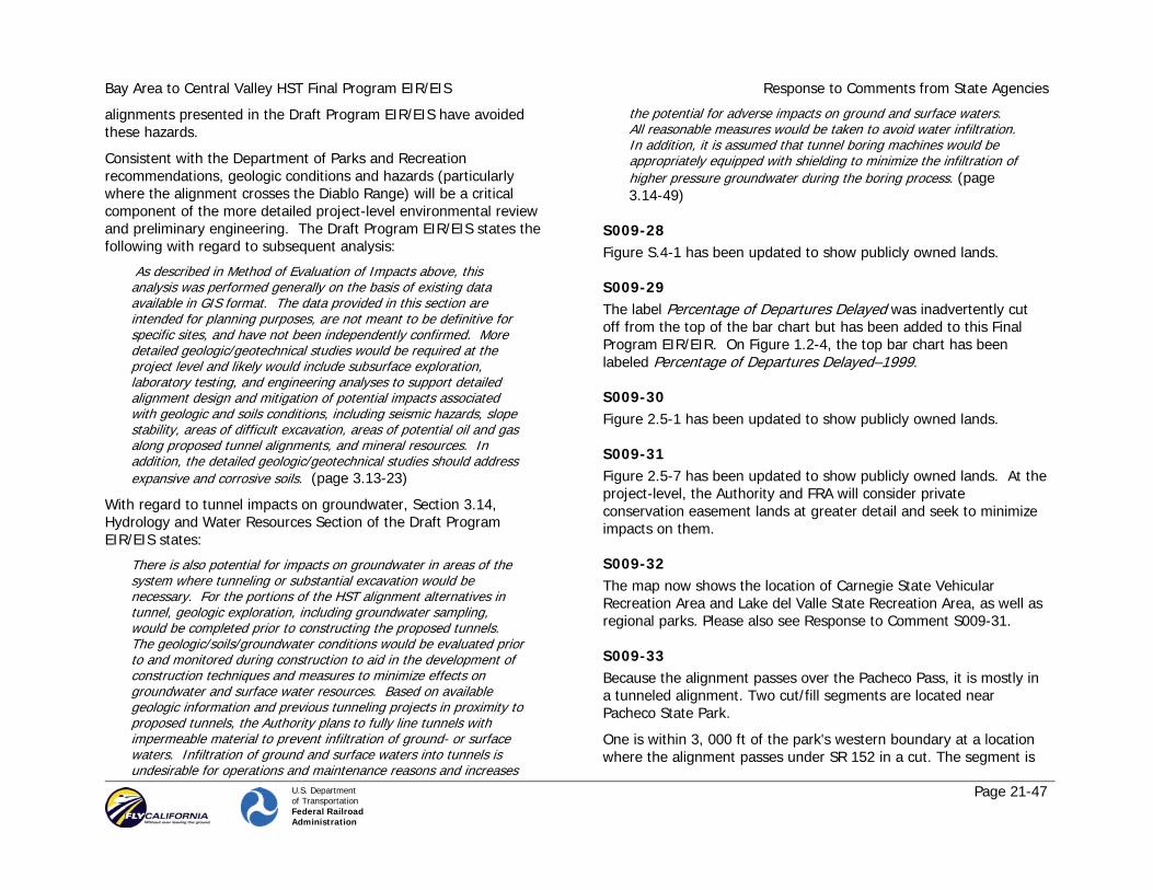
Bay Area to Central Valley HST Final Program EIR/EIS Response to Comments from State Agencies
U.S. Department of Transportation Federal Railroad Administration
Page 21-47
alignments presented in the Draft Program EIR/EIS have avoided these hazards.
Consistent with the Department of Parks and Recreation recommendations, geologic conditions and hazards (particularly where the alignment crosses the Diablo Range) will be a critical component of the more detailed project-level environmental review and preliminary engineering. The Draft Program EIR/EIS states the following with regard to subsequent analysis:
As described in Method of Evaluation of Impacts above, this analysis was performed generally on the basis of existing data available in GIS format. The data provided in this section are intended for planning purposes, are not meant to be definitive for specific sites, and have not been independently confirmed. More detailed geologic/geotechnical studies would be required at the project level and likely would include subsurface exploration, laboratory testing, and engineering analyses to support detailed alignment design and mitigation of potential impacts associated with geologic and soils conditions, including seismic hazards, slope stability, areas of difficult excavation, areas of potential oil and gas along proposed tunnel alignments, and mineral resources. In addition, the detailed geologic/geotechnical studies should address expansive and corrosive soils. (page 3.13-23)
With regard to tunnel impacts on groundwater, Section 3.14, Hydrology and Water Resources Section of the Draft Program EIR/EIS states:
There is also potential for impacts on groundwater in areas of the system where tunneling or substantial excavation would be necessary. For the portions of the HST alignment alternatives in tunnel, geologic exploration, including groundwater sampling, would be completed prior to constructing the proposed tunnels. The geologic/soils/groundwater conditions would be evaluated prior to and monitored during construction to aid in the development of construction techniques and measures to minimize effects on groundwater and surface water resources. Based on available geologic information and previous tunneling projects in proximity to proposed tunnels, the Authority plans to fully line tunnels with impermeable material to prevent infiltration of ground- or surface waters. Infiltration of ground and surface waters into tunnels is undesirable for operations and maintenance reasons and increases
the potential for adverse impacts on ground and surface waters. All reasonable measures would be taken to avoid water infiltration. In addition, it is assumed that tunnel boring machines would be appropriately equipped with shielding to minimize the infiltration of higher pressure groundwater during the boring process. (page 3.14-49)
S009-28 Figure S.4-1 has been updated to show publicly owned lands.
S009-29 The label Percentage of Departures Delayed was inadvertently cut off from the top of the bar chart but has been added to this Final Program EIR/EIR. On Figure 1.2-4, the top bar chart has been labeled Percentage of Departures Delayed–1999.
S009-30 Figure 2.5-1 has been updated to show publicly owned lands.
S009-31 Figure 2.5-7 has been updated to show publicly owned lands. At the project-level, the Authority and FRA will consider private conservation easement lands at greater detail and seek to minimize impacts on them.
S009-32 The map now shows the location of Carnegie State Vehicular Recreation Area and Lake del Valle State Recreation Area, as well as regional parks. Please also see Response to Comment S009-31.
S009-33 Because the alignment passes over the Pacheco Pass, it is mostly in a tunneled alignment. Two cut/fill segments are located near Pacheco State Park.
One is within 3, 000 ft of the park's western boundary at a location where the alignment passes under SR 152 in a cut. The segment is

Bay Area to Central Valley HST Final Program EIR/EIS Response to Comments from State Agencies
U.S. Department of Transportation Federal Railroad Administration
Page 21-48
approximately 2,600 ft long and more than 120 ft deep. It is unlikely that the tracks or overhead contact system would be visible from anywhere in the park. The top of the slopes of the cut would be visible, but overtime would re- vegetate and blend in with the surrounding landscape.
The second segment is more than 1 mile from the park and approximately 1 mile in length. It consists of both a cut and fill segment, varying on average from a 150 ft cut to a 120 ft fill. The segment is separated from both the park and SR 152 by a ridge, blocking it from view.
These conditions render the visual impact of the proposed HST alignment from Pacheco State Park as None, especially when considering the High visual impact of SR 152 in the same area.
S009-34 The Authority and FRA are keenly aware of the visual sensitivity of the Pacheco Creek area. Development of the design and visual elements of the bridges and HST alignment through this area will include consultation with stakeholders and coordination with public agencies with interests in the affected area, (e.g., open space groups, Caltrans, and Department of Parks and Recreation).
With regard to excavated soils, Section 3.1, Construction Impacts, of the Draft Program EIR/EIS states:
To avoid or limit potential impacts along the surface above the tunnels, the selected HST system has limited surface access for ventilation and/or evacuation through tunnel design. The potential impacts associated with construction access roads would be greatly limited, and avoided altogether in some sensitive segments (as defined at the project level), by using in-line construction, i.e., by using the new rail infrastructure as it is built to transport equipment to and from the construction site and to transport excavated materials away from the construction area and to appropriate re-use or disposal sites. To avoid the creation of access roads in sensitive areas (as defined at the project level), it may be necessary to conduct geologic exploration using helicopter transport for drilling equipment and restoring sites after use, which would result in minimal surface disruption. Small pilot tunnels
would be used where more extensive subsurface geology information is needed. (page 3-18-7)
S009-35 The methodology for categorizing the potential paleontological sensitivity is appropriate for a program-level analysis. The rating of high or low does not take away from the potential to identify resources as part of the Tier 2 project-level environmental analysis. The alignment segment from San Luis Reservoir to Valley Floor near the San Luis Reservoir State Recreation Area was identified to have a high sensitivity.
S009-36 The discussion has been revised for the alignment alternatives discussed in Section 3.12.3, East Bay to Central Valley, to match the results shown in Table 3.12-1.
S009-37 The text on top of page 3.12-29 in the Draft Program EIR/EIS was not part of C. PALEONTOLOGICAL RESOURCES but is part of the overall discussion of 3.12.6.
Comparative information on paleontological resources by alignment alternative is included in Table 3.12-A in the appendices and summarized in Section 3.12.3.
As noted in Section 3.12.5, as a design practice the Authority and FRA are committed to avoiding potential impacts on cultural resources through careful alignment alternative design and selection. The Authority is committed to avoiding impacts on cultural resources to the extent feasible and practical.
The preparation of a paleontological resources treatment plan is included as part of subsequent analysis (Section 3.12.7) to be conducted as part of the Tier 2 project-level environmental analyses. Specific mitigation measures will be developed as part of this treatment plan.

Bay Area to Central Valley HST Final Program EIR/EIS Response to Comments from State Agencies
U.S. Department of Transportation Federal Railroad Administration
Page 21-49
S009-38 As noted in Section 3.13.1, Regulatory Requirements and Methods of Evaluation, in “Geology and Soils,” the rating system for the potential for surface rupture for HST was “High if any part of the site is within 200 ft (60 m) of an active or potentially active (Quaternary) fault; otherwise, low” (page 3.13-3). This methodology was applied uniformly for all stations.
S009-39 The spelling of seismic and Luis have been corrected.
S009-40 Pacheco State Park and the San Luis Reservoir State Recreation Area would not be affected by the alignment alternatives in the San Jose to Central Valley Corridor. These recreational areas are located south of the proposed alignment alternatives.
S009-41 Please see Response to Comment S009-40.
Appendix 2D is at sufficient level of detail for the program level of analysis. The alignments are overlaid on color photo-imagery of the corridors. If additional information such as requested in the comment were put on the maps, they would become more illegible. The Authority created these maps without the additional information with two primary goals: 1) to let the satellite imagery speak for itself and 2) to reduce the number of maps to reduce cost and the unnecessary use of paper. The Authority is able and willing to share its alignment files with a requesting party such as the Department of Parks and Recreation so that they can make their own maps with the alignment data.
In Section 3.18, Construction Methods, there is an acknowledgement that this project:
has the potential to generate large quantities of material—from pavement demolition, clearing and grubbing, and soil/rock—that is anticipated to be suitable for reuse in the construction of the
proposed HST facilities. Potential uses include aggregate for concrete and fill material for other portions of the line.
Also the Construction Methods section states that:
by using the new rail infrastructure as it is built to transport equipment to and from the construction site and to transport excavated materials away from the construction area and to appropriate reuse or disposal sites.
It is the Authority’s intention to reuse or dispose of the tunnel spoils in the most useful way possible.
S009-42 These species are listed in Appendix 3.15-A. The California tiger salamander was added to the GEA North Alignment Alternative (note that the GEA North Alignment Alternative is not included as part of the preferred network alternative). The project alternatives are not located near the McConnell or George J. Hatfield State Recreation Areas or the Caswell Memorial State Park.
S009-43 Detailed mitigation measures for the HST project will be defined in the project-level environmental review and preliminary engineering phase of the project. At the program level, the Authority and FRA have included broad-level mitigation strategies that will be further refined in future project-level environmental documents. The broad-level mitigation strategies listed in Section 3.16, as well as other sections of the Program EIR/EIS, generally account for those listed for this comment.
1. See Section 3.16.6, number 11, regarding compensation for the temporary loss of revenue. Specifics of mitigation strategies will be developed as part of the Tier 2 environmental analysis.
2. See Section 3.16.6, number 6, regarding compensation for the lost park and recreation use. Specifics of mitigation strategies will be developed as part of the Tier 2 environmental analysis.
3. See mitigation strategies in Section 3.1.5 regarding the use of offsite parking and shuttles as well as the preparation of the

Bay Area to Central Valley HST Final Program EIR/EIS Response to Comments from State Agencies
U.S. Department of Transportation Federal Railroad Administration
Page 21-50
traffic management plan, which could include the use of shuttles for park visitors during construction. Also see Section 3.16.6, number 10, regarding scheduling of construction to minimize impacts. Specifics of mitigation strategies will be developed as part of the Tier 2 environmental analysis.
4. See Section 3.16.6, number 7, regarding restoration to a natural state. Specifics of mitigation strategies will be developed as part of the Tier 2 environmental analysis.
5. See Section 3.16.6, number 8, regarding planning studies and design. Specifics of mitigation strategies will be developed as part of the Tier 2 environmental analysis.
6. Should impacts from the HST system be considered to reduce the park value of a California Department of Parks and Recreation system unit, the Authority and FRA will work collaboratively with the Department of Parks and Recreation. See Section 3.16.6, number 6, regarding compensation for the loss of park value. Specifics of mitigation strategies will be developed as part of the Tier 2 environmental analysis.
7. See Section 3.16.6, number 8, regarding planning studies. Specifics of mitigation strategies will be developed as part of the Tier 2 environmental analysis.
8. See Section 3.16.6, number 8, regarding planning studies. Specifics of mitigation strategies will be developed as part of the Tier 2 environmental analysis.
9. The Authority and FRA will provide fair market value, consistent with federal and state acquisition laws and regulations, for real property loss incurred by the California Department of Parks and Recreation. See Section 3.7 regarding the Federal Uniform Relocation and Real Property Acquisition Policies Act of 1970, as amended. Specifics of mitigation strategies will be developed as part of the Tier 2 environmental analysis.
10. Construction vehicle cleaning to prevent the spread of weeds or invasive species is included as a mitigation strategy in Section 3.15.5. In addition, the preparation of biological resource
management plans is included as a mitigation strategy to ensure the long-term perpetuation of the existing diversity of habitats in the project area and adjacent urban interface zones. Specifics of these mitigation strategies, including the appropriate areas to be covered, will be developed as part of the Tier 2 environmental analysis.
11. To the extent possible, disturbed soil will be revegetated with local native plants. This is generally identified in Section 3.15.5 as part of the preparation of biological resource management plans. Specifics of this mitigation strategy will be developed as part of the Tier 2 environmental analysis.
12. Mitigation strategies, including erosion control best management practices, are discussed in Section 3.14.5. This is also identified in Section 3.15.5 as part of the preparation of biological resource management plans. Specifics of these mitigation strategies will be developed as part of the Tier 2 environmental analysis.
13. See Section 3.16.6, number 4, regarding minimization of visual impacts. Specifics of mitigation strategies will be developed as part of the Tier 2 environmental analysis.
14. As noted in Section 3.15.5, functional corridors would be established to provide connectivity to protected land zoned for uses that provide wildlife permeability. Additional measures are discussed in 3.15.5 for mitigating impacts on wildlife corridors. Specifics of mitigation strategies will be developed as part of the Tier 2 environmental analysis.
15. As noted in Section 3.15.5, wildlife crossings would be of a design, shape, and size to be sufficiently attractive to encourage wildlife use. Overcrossings and undercrossings for wildlife would be appropriately vegetated to afford cover and other species requirements.
16. As part of the preliminary engineering and project-level EIR/EIS, the Authority and FRA will work with the California Department of Parks and Recreation to avoid or minimize impacts from both construction and operation of the HST system, including lighting,

Bay Area to Central Valley HST Final Program EIR/EIS Response to Comments from State Agencies
U.S. Department of Transportation Federal Railroad Administration
Page 21-51
shading, protection of critical wildlife corridors, and visitor use areas.
S009-44 The Authority and FRA determined that the extensive information contained in the Draft Program EIR/EIS and the substantial public comment received on the draft (including comments from the Department of Parks and Recreation) are sufficient to define a Preferred Alternative, as identified in this Final Program EIR/EIS. Please see Standard Response 3 and Chapter 8 regarding identification of the Pacheco Pass as the Preferred Alternative. The underlying rationale for the Preferred Alternative is provided in the document entitled, Draft Staff Recommendations: Preferred Network Alternative, HST Alignment and Station Locations, included as Appendix 8A of this Final Program EIS/EIR. Definition of the Pacheco Pass Alternative as the Preferred Alternative took into account numerous factors, as noted in the report. Impacts on the biologically diverse pristine areas—the critical park and preserve resources—through the Diablo Range were not taken lightly but were weighed against multiple other impacts and benefits of the various alignment alternatives and station location options.
The Authority and FRA note that the Altamont alignment alternatives that serve San Francisco have impacts on the San Francisco Bay and the Don Edwards Wildlife Refuge and do not agree with the Department of Parks and Recreation overall conclusion that the Altamont alternatives are less environmentally damaging.
The Authority and FRA have made substantial efforts, at this program and conceptual planning level, to reduce impacts along the Preferred Alternative, including extensive use of tunnels through the Diablo range. During the project-level environmental review and preliminary engineering, more detailed mitigation measures will be developed to further reduce or eliminate the impacts on these resources.
S009-45 The Authority and FRA will continue to coordinate and consult with the Department of Parks and Recreation throughout the development of the HST system, including during the project-level environmental review and preliminary engineering. The Authority and FRA will continue to pursue, with the help of Department of Parks and Recreation and others, methods to avoid or reduce direct, indirect, and cumulative impacts from the construction and operation of a HST system on the State’s critical natural resources, including the State Park System. The Authority and FRA appreciate the contact information and offer to provide additional information or clarification regarding the comments.

Bay Area to Central Valley HST Final Program EIR/EIS Response to Comments from State Agencies
U.S. Department of Transportation Federal Railroad Administration
Page 21-52
Comment Letter S010 (John Garamendi, Lieutenant Governor, October 15, 2007)
Bay Area to Central Valley HST Final Program EIR/EIS Response to Comments from State Agencies
U.S. Department of Transportation Federal Railroad Administration
Page 21-53
Comment Letter S010 – Continued

Bay Area to Central Valley HST Final Program EIR/EIS Response to Comments from State Agencies
U.S. Department of Transportation Federal Railroad Administration
Page 21-54
Response to Letter S010 (John Garamendi, Lieutenant Governor, October 15, 2007)
S010-1 The Authority and FRA are pleased with the interest shown in the statewide HST system and in the number of people, agencies, and organizations that have taken the time to provide comments on the Draft Program EIR/EIS and attend the public hearings held throughout northern California.
The Authority and FRA are keenly aware that the decisions they make regarding HST alignment and station locations will affect not only Sacramento but the entire State of California. The Authority and FRA are pleased that they were able to offer the opportunity for citizens, agencies, and organizations to attend public hearings not only in Sacramento but throughout northern California and the Central Valley, with eight hearings held in San Francisco, San Jose, Livermore, Oakland, Gilroy, Merced, Stockton, and Sacramento.
The Authority and FRA are also pleased that they were able to extend the public review comment period on the Draft Program EIR/EIS from September 28 to October 26, 2007, in response to requests from agencies and the public, thus allowing for the extensive public comments that we have received on the Draft Program EIR/EIS.
S010-2 The Authority and FRA appreciate the Lieutenant Governor’s support for the HSR project in California and agree that there is a need to address the ever-increasing congestion levels on our transportation system.
S010-3 The Authority and FRA acknowledge and appreciate the Lieutenant Governor’s early involvement in the planning and legislative actions for an HST system in California. The Authority and FRA agree that much progress has been made and much remains to be done.
As shown in this volume of the Final Program EIR/EIS, the Authority and FRA have received extensive public input via a substantial number of public and agency comments on the Draft Program EIR/EIS, and this public input has clearly assisted the Authority Board in its deliberations.
S010-4 The Authority and FRA understand and take very seriously their obligations to the State of California and the overall purpose of the HST Program. Chapter 1, “Purpose and Need and Objectives,” of the Draft Program EIR/EIS notes that:
the purpose of the Bay Area HST is to provide a reliable high-speed electrified train system that links the major Bay Area cities to the Central Valley, Sacramento, and Southern California, and that delivers predictable and consistent travel times. Further objectives are to provide interfaces between the HST system and major commercial airports, mass transit and the highway network and to relieve capacity constraints of the existing transportation system in a manner sensitive to and protective of the Bay Area to Central Valley region’s and California’s unique natural resources. (page 1-4)
The Authority and FRA also understand the legal and regulatory environment (e.g., NEPA and CEQA) within which the program must proceed.
S010-5 The Authority and FRA appreciate and respect the Lieutenant Governor’s statement favoring the Altamont route as the preferred alternative. Numerous others have offered a similar view, as shown in this volume of the Final Program EIR/EIS. The Authority and FRA have, however, identified Pacheco Pass as the Preferred Alternative in this Final Program EIR/EIS, and this position is also supported by many, again as evidenced by the public comments in this volume of the Final Program EIR/EIS. Please see Standard Response 3 and

Bay Area to Central Valley HST Final Program EIR/EIS Response to Comments from State Agencies
U.S. Department of Transportation Federal Railroad Administration
Page 21-55
Chapter 8 regarding the identification of Pacheco Pass as the Preferred Alternative.
S010-6 Comment acknowledged. The Final Program EIS/FEIR includes a discussion of global climate change (Section 3.3).
S010-7 The impact of the HST system on air quality would primarily come from the reduction of intercity auto trips. The ridership, vehicle emission, and air emission reductions are generally equivalent for the Pacheco and Altamont alternatives. Section 3.3 has been refined to show a comparison of the air emission reductions for Pacheco Pass and Altamont Pass alternatives.
S010-8 The Pacheco Pass alternative identified in this Final Program EIS/EIR as the Preferred Alternative would not involve a San Francisco Bay crossing. Please see Standard Response 3 and Chapter 8 regarding the identification of Pacheco Pass as the Preferred Alternative.
The two Altamont Pass network alternatives that require a new transbay tube, including the one proposed by the Lieutenant Governor, would have high potential environmental impacts and considerable construction issues. These alternatives would have more than 36 acres of potential direct impacts on the San Francisco Bay. They would have 38.8 acres of potential impacts on water bodies (lakes and San Francisco Bay), whereas the Oakland and San Jose Termini Altamont Pass network alternative would have 2.3 acres of potential direct impacts.
The cost of the additional 8.8-mile HST segment needed to implement a new transbay tube is estimated at about $4.6 billion— over $500 million per mile. Moreover, there is only slightly higher ridership and revenue potential (less than 2% higher ridership or 1.0–1.6 million passengers per year by 2030) when comparing the transbay tube alternative via the East Bay versus the related Altamont Pass network alternative that terminates in Oakland.
To implement alternatives that included a new transbay tube, coordination would be required with the U.S. Army Corps of Engineers (USACE) under Section 10 of the Rivers and Harbors Act, USFWS, and the California Coastal Commission. Crossing the Bay would also be subject to the USACE, CDFG, and Bay Conservation and Development Commission permit process. Please also refer to Response to Comment S010-5.
Please also see Response to Comment L001-2 for a discussion of service to the Central Valley.
S010-9 Please see Response to Comment L001-2 for a discussion of service to the Central Valley and to Sacramento.
S010-10 The Draft Program EIR/EIS does not assert that the capital costs or travel times are virtually the same for the Altamont Pass and Pacheco Pass alternatives but rather provides actual values by alignment and network alternative for these metrics. The reader can therefore calculate the differences among the alignment and network alternatives and do a direct comparison. Visual and aesthetic impacts are also described on an alignment basis. The Authority and FRA agree that there are important environmental differences among the Altamont Pass and Pacheco Pass alternatives.
S010-11 Comment acknowledged.
As noted in Chapter 7, the Altamont Pass and Pacheco Pass network alternatives present a range of reasonable alternatives for the purpose of analyzing potential environmental effects, such as those on agricultural lands. The Pacheco Pass network alternatives do have additional farmland impacts as a result of including the BNSF-UPRR alignments, while the Altamont Pass network alternatives included the UPRR alignments through the Central Valley. Compared to the Altamont Pass network alternatives using the UPRR alignments, farmlands impacts for the BNSF-UPRR alignments were

Bay Area to Central Valley HST Final Program EIR/EIS Response to Comments from State Agencies
U.S. Department of Transportation Federal Railroad Administration
Page 21-56
identified to be higher by about 250 acres. Subsequent Tier 2 environmental documents will analyze both the BNSF-UPRR and UPRR alignments.
As noted in Section 2.3.2, Design Practices, use of existing transportation corridors would be maximized to avoid or minimize impacts. Use of transportation corridors includes placing HST alignments either within or adjacent to a major existing transportation corridors. In addition, future project-level environmental analyses will be coordinated with detailed engineering to further refine the HST alignments and station locations and avoid or minimize farmland impacts to the greatest extent practicable.
S010-12 By placing HST alignments either within or adjacent to existing transportation corridors, impacts on the floodplain would be limited to locations where the alignments would be outside an existing corridor. As noted in Section 3.14, the San Jose to Central Valley corridor alignment alternatives extend at-grade or on aerial structure through the 100-year floodplains. The largest area of floodplain being crossed is between Gilroy and the Diablo Range, with other locations near Morgan Hill and along Henry Miller Road. Existing transportation facilities adjacent to the proposed HST already act as a barrier to floodflows at many of these locations. Where the HST would have an impact, measures would be implemented to restore the floodplain to its prior operation by constructing culverts under the tracks to convey anticipated storm flows and to minimize ponding. Impacts on the floodplain from aerial structures would be limited to column footings. Future Tier 2 project-level environmental analyses will be coordinated with detailed engineering to further refine the HST alignments and station locations and avoid or minimize impacts to the greatest extent practicable.
S010-13 Ridership forecasts do not show a major difference in Vehicle Miles Traveled (VMT) or in vehicle trip reductions on I-580 and SR 99 for the Altamont alternative compared with the Pacheco alternative. For I-580 between Livermore and I-5, the Pacheco alternative achieves a
5.4% reduction in peak traffic, while the Altamont alternative achieves a 5.7% reduction. For SR 99 between Ripon and Merced, the Pacheco alternative achieves a 2.8% reduction in peak traffic, while the Altamont alternative achieves a 3.0 % reduction (Table 3.1-2 in Section 3.1, Traffic, Transit, Circulation, and Parking).
S010-14 Each of the subject impact categories are discussed below.
S010-15 Several design elements have been employed to minimize or avoid direct and indirect impacts on resources of concern, including tunneling, elevated alignments, and alignments adjacent to existing transportation rights-of-way. The environmental analysis for the Draft Program EIR/EIS was conducted at a program level and identifies the need for field reconnaissance-level surveys to be conducted in the future at the project level. These future surveys will determine specific habitat conditions and impacts along the Henry Miller alignment alternative and the entire preferred HST network alternative. These more detailed surveys will identify specifically where impacts on wetlands, sensitive habitat, and special-status species could occur and where focused species surveys are required. The Henry Miller alignment alternative and other alignment alternatives using the Pacheco Pass will be further designed at the project level to avoid or minimize potential impacts. Broad program mitigation strategies have been identified and will be further refined and applied at the project level to mitigate impacts.
Where potential vibration impacts may occur, including sensitive habitats, measures would be employed to minimize those impacts. This includes using train and track technologies that minimize ground vibration, such as state-of-the-art suspensions, resilient track pads, tie pads, ballast mats, or floating slabs.
S010-16 See Standard Response 4 regarding growth. Please also see Chapter 5.

Bay Area to Central Valley HST Final Program EIR/EIS Response to Comments from State Agencies
U.S. Department of Transportation Federal Railroad Administration
Page 21-57
S010-17 The GEA was identified in the Draft Program EIR/EIS (Section 3.15.2) and is in this Final Program EIR/EIS. Please see Response to Comments S006-4 and S006-5.
S010-18 Section 3.3 of this Final Program EIR/EIS includes the greenhouse gas emissions from the two major alternatives (Altamont Low, Pacheco Low).


![DEPARTMENT OF TRANSPORTATION Federal Railroad … · 2020. 12. 17. · 4910-06-P DEPARTMENT OF TRANSPORTATION Federal Railroad Administration 49 CFR Part 236 [Docket No. FRA-2019-0075]](https://static.fdocuments.us/doc/165x107/60b34d8eac2f3a674c692a93/department-of-transportation-federal-railroad-2020-12-17-4910-06-p-department.jpg)