U.S. DEPARTMENT OF THE INTERIOR U.S. … · E STRATIGRAFI A CRA CCNOZOICO o u o o kl _l < «L...
63
U.S. DEPARTMENT OF THE INTERIOR U.S. GEOLOGICAL SURVEY Coal in Latin America: 1992 Uruguay, Argentina, Chile, Peru, Ecuador, Colombia, Venezuela, Brazil, and Bolivia by Jean N. Weaver 1 Open-File Report 93-239 This report is preliminary and has not been reviewed for conformity with U.S. Geological Survey editorial standards (or with the North American Stratigraphic Code). Any use of trade, product, or firm names is for descriptive purposes only and does not imply endorsement by the U.S. Government. 1 USGS, Denver, Colo. 1993 REPRODUCED FROM BEST AWttUBLE COPY
Transcript of U.S. DEPARTMENT OF THE INTERIOR U.S. … · E STRATIGRAFI A CRA CCNOZOICO o u o o kl _l < «L...

U.S. DEPARTMENT OF THE INTERIOR
U.S. GEOLOGICAL SURVEY
Coal in Latin America: 1992Uruguay, Argentina, Chile, Peru, Ecuador,Colombia, Venezuela, Brazil, and Bolivia
by
Jean N. Weaver1
Open-File Report 93-239
This report is preliminary and has not been reviewed for conformity with U.S. Geological Survey editorial standards (or with the North American Stratigraphic Code). Any use of trade, product, or firm names is for descriptive purposes only and does not imply endorsement by the U.S. Government.
1 USGS, Denver, Colo.
1993
REPRODUCED FROM BEST AWttUBLE COPY

TABLE OF CONTENTSPage
Executive summary ...................... 1Acknowledgments ....................... iConclusions ......................... 2Summary of trip ....................... 2Benefits to USGS/DOI .................... 2Recommendations ....................... 4Country summary ....................... 4Uruguay ........................... 6Argentina .......................... 9Chile ............................ 14Peru ............................ 19Ecuador ........................... 27Colombia .......................... 30Venezuela .......................... 44Brazil ........................... 50Bolivia ........................... 54Selected references ..................... 55Appendix A: counterparts .................. 56
COUNTRY MAPS
Uruguay ........................... 5Argentina .......................... 8Chile ............................ 13Peru ............................ 18Ecuador ........................... 26Colombia .......................... 29Venezuela .......................... 43Brazil ........................... 49Bolivia ........................... 53
TABLES
1. Coal reserves in Argentina ................ 112. MINERPERU's coal reserve estimates ............ 223. Figures on Colombian coal exports
quantity and destination ................. 334. Coal quality from the Cerrejon North Zone ........ 355. Quality of coal from the three mines
Carbones del Caribe S.A. ................. 376. Quality of coal from the three mines
Carbones del Caribe S.A.................. 387. Prodeco coal quality analysis .............. 40

FIGURESPage
1. Map of South America .................. 32. Location of some drill holes in the Canada
de los Burros coal region, northern Uruguay ....... 73. Schematic distribution of the coal occurrences
in western Argentina .................. 104. Location of the Pecket and ENACAR coal mines ...... 155. Major coal regions in Peru ............... 206. Area being investigated by ELECTROPERU
for a coal-fired electric plant ............. 247. Coal basins in Ecuador ................. 288. Coal basins in Colombia ................. 319. Major ports and railway systems which
control export of coal ................. 3210. Location of the coal mines of Carbones del Caribe S.A. . 3611. Location of Drummond Ltd. coal mine ........... 4212. Major coalfields in Venezuela .............. 4513. Coal regions in Brazil ................. 5114. Geologic sketch map of southern Brazil
showing the major coalfields .............. 52
11

EXECUTIVE SUMMARY
The purpose of a Temporary Duty Assignment with the Office of International Geology (OIG), was to update available information about coal in South America. This was accomplished through a trip to nine countries where the approach was twofold: 1) to discuss with geologists and other authorities in each country the quantity, quality, and distribution of known coal resources, and the status of coal exploration, recovery, and utilization in each country; and 2) to inform them of the current role of coal research in the U.S. Geological Survey, to determine their research needs and capabilities, and to evaluate the desirability of cooperative studies of mutual benefit. The first Coal Map of South America will be prepared and published by the USGS as a result of this trip.
ACKNOWLEDGMENTS
Numerous geologists, consultants, mining engineers, and economists in each country were visited and to all of them I owe my sincere thanks and gratitude. I was warmly received and through each person's generosity was able to obtain data that will enhance the accuracy of the Coal Map of South America.

CONCLUSIONS
All nine countries that were visited contain coal deposits. Some of the known deposits are more economic to exploit than others, but most could be developed to some extent for local use. Export of Venezuelan and Colombian coal may increase in the near future. Continued monitoring of activities in these countries could benefit the US coal market. Deforestation is an environmental concern in many parts of Latin America. For this reason, coal as an alternative energy source will/should be developed. If and when this happens, opportunities should be present for foreign companies to invest in, and actively participate in, coal development and utilization programs in South America.
SUMMARY OF TRIP (see fig. 1)
Weaver met local geologists and other responsible authorities in each country. Coal occurrences were defined and utilization options were addressed. Weaver visited an underground/undersea coal mine near Lota, Chile, as well as open- pit mines in NE Colombia and NW Venezuela. All coal presently mined in Venezuela and Colombia is for export. Coal in Colombia has been used in the past by the steel industry, but no reports of present activity were received on this trip. In 1993, Colombia plans a briquetting project to test usage of coal for drying coffee beans. This is the only plan, so far, to use coal in-country in Colombia. Most countries recognize an on-going and increasing deforestation problem and realize that coal would be a preferable alternative energy source for domestic and industrial sectors. Government regulations and economics dictate whether conversion to coal will eventually take place. Weaver also presented information concerning the new coal course which will be offered in 1993 by the USGS and Pennsylvania State University. This was well received but sources for funding posed a problem. Potential for cooperative coal research programs exists but contacts must continue to further examine these opportunities.
BENEFITS TO USGS/DOI
Compilation of a Coal Map of South America has enhanced cooperative and technical research among scientists with the USGS/DOI and counterpart agencies within Central and South America. New geologic and economic information will be gained. Data presented on and with the map will span the scientific, economic, and academic sectors and complement the recently published Coal Map of North America. This cooperative mapping project has promoted an exchange of geologic data and will foster a better understanding of coal resource and utilization potential in the Western Hemisphere.

ATLANTIC OCEAN
ATLANTIC OCEAN

RECOMMENDATIONS
All the countries expressed an interest in cooperative research; however, following an evaluation of the nine countries coal resource potential and current level of development, three countries have the highest priority in the near term: Chile, Bolivia, and Ecuador.
Chile has a long history of mining coal underground near the coastal town of Lota. Recent acquisition of mining rights near Tierra del Fuego has prompted the need to start planning an open-pit coal mine. USGS expertise was solicited for the study of the lease because ENACAR (the government-owned coal company) has little or no expertise along these lines. The Lota Mine extends up to 3 km (1.8 mi) under the Pacific Ocean, so examining the surficial outcrops is impractical. It will be important to establish how ENACAR would use the mined coal. Assistance could be reevaluated if ENACAR plans to export all the mined coal.
Bolivia has the smallest number of coal occurrences but peat deposits appear to be extensive. Depletion of an already sparse vegetation on the Altiplano has led to some thought about searching out other energy sources. Peat, besides serving as an alternative heat source for generation of electricity and for domestic heating, could also be used as a soil amendment for cultivation.
Ecuador has some coal deposits but very little emphasis has been placed on the resource as an alternative energy source. The Latin American Energy Organization (OLADE) is based in Quito and recent work has focused on coal utilization in South American countries. A USGS/OLADE-sponsored workshop was proposed. The workshop would 1) emphasize sharing of research information and activities to reduce duplication of effort, and 2) identification of research and development opportunities needed to promote increased use of coal in environmentally acceptable manners. Peru, Chile, Ecuador, and Colombia have all recognized and addressed the fact that deforestation is a serious and on-going problem which needs to be alleviated.
The cooperative endeavors that have assisted the completion of the Coal Map of South America must be continued with routine information exchanges and attempts to address mutual problems through coordinated activities. A large number of agencies, organizations, and individuals have interests and responsibilities in the field of energy. Reciprocal, conjoint research activities can be an important element in providing information for use in energy development, energy policies, and environmental protection in our hemisphere.
COUNTRY SUMMARY
The countries are listed in the order in which they were visited. All counterparts and their addresses are found at the end of this report. Because this report is condensed, detailed information on coalfields is not included. Information on occurrences of coal will appear with the forthcoming Coal Map of South America. The references listed represent a condensed version of the most recent and comprehensive publications on coal in South American countries.

URUGUAY Interactional boundary
Opartamento boundary
National capital
e Oepart»mento capital
Railroad
Road
,C U A R ^ M 5 O
3 R I D A /
r L .4 .v ? / c
OUNDAHT MCFftCCCMTATION I*
." NOT HICC«««.BILT AUTHOKITATIVC
Base 53826 4-66

URUGUAY
Coal occurrences have been reported in Canada de los Burros, in the Department of Cerro Largo in the northern section of the country. The Chaco Parano sedimentary basin, which is a continuation of the wide belt of Gondwana sediments in southern Brazil, extends into Uruguay through the departments of Rivera, Tacarembo, Cerro Largo, and northeast Duranzo, covering approximately 25,000 sq km.
Discussions with Dr. Hugo B. Tosi and Jorge S. da Silva, geologists from the Direccion Nacional de Mineria y Geologla (DINAMIGE), indicated that coal was first noticed in-country as early as 1882. Holes drilled in 1909 showed two beds of approximately 4 m (13 ft) each, at a depth of 16 m (52 ft) . Renewed interest in drilling occurred in the early 1930's with two holes in the Canada de los Burros showing two beds of 1 m (3.2 ft) and 1.20 m (3.6 ft) in thickness. Some holes were also drilled on the western edge of the basin and reports indicate the presence of lenticular lignite beds under an existing basalt layer. Correlations with the coal beds near the Canada de los Burros would be difficult owing to the extensive tectonic activity in the central part of the basin. Several outcrops have been described, the main one located in the Rio del los Burros. It is only visible at low water level. In 1981, in association with geologic mapping at 1:40,000 scale, 18 holes were drilled in the Picada de Gregorio-Canada de los Burros-Cuchilla de Melo area in northern Uruguay (fig. 2) . Coal beds were found, and some samples obtained, but inconsistency in data description, time lapse between obtaining the core, and analysis of samples contribute to a lack of uniformity in data and accuracy of results.
The coal is Early Permian age, is high in ash and sulfur, and is part of the Tres Isla Formation. The Tres Isla Formation is equivalent to the coal-bearing Rio Bonito Formation in southern Brazil. There have not been any detailed geologic studies of the Tres Isla Formation.
The available information on quantity and quality of coal does not allow definitive conclusions about resource potential. Field investigations and drilling are needed to define the geometry of the coal deposits and provide samples for physical and chemical analyses so utilization possibilities can be determined.

PICADA DE GREGORIOCANADA DE LOS BURROS
CUCH1LLA DE MELO
68O 662
E STRATIGRAFI A
CRA
CCNOZOICO
o uo
okl
_l<«L
FCRIODO
CUATCRNARIO
PCRMICO
PCRMO
CARBON irERO
rORW ACION
1 3 Oelervi
1 . ; . ; ; 1 3 Yofvcri inferior
| ! I 1 jj Mon^rull*
|>##^ Froyl* Mu*<-l«
r.V.-.j Tr«t uiot
KCFCRCNCIAS
----- Tfoclura j/e dieci
" Fcllo inUrido
^" Duxomicnle
O P«rf«raeie'n
Cwrtc «o cquo
Coniine >*cun4«n
Figure 2 Location of some of the drill holes in the Canada de los Burros region, northern Uruguay (DINAMIGE, 1986)

Argentinay ''*
\ ''^VARAG
PACIFIC '^"W fS« : --". JX^,^ / ^,,,t-^ri«^r^^
_-25^* s /V_X**> / Tj& i CchniitMHerif ^"" Vo£i«*
- is^.,,-^_ FALKLAND ISLANDS'' flSLAS MALV1NASI
;«tt ; 56rab«r. Conlo'm*! Projection r.Cttd p.-.IItU 37*30' »ntf 50'1 5'
Scilc I 16.000.000

ARGENTINA
Coal has been reported at about 250 separate surface localities in Argentina, in 14 provinces and the territory of Tierra del Fuego (fig. 3). Many of these are isolated occurrences of coal consisting of thin, impure, and lenticular beds. Coal is presently being mined in one area in southern Argentina, the Rio Turbio coalfield.
The Rio Turbio coalfield is in the southwestern corner of Santa Cruz Province at the foothills of the Andes Mountains, about 250 m (800 ft) above sea level. The coalfield and the town of Rio Turbio are about 260 km (162 mi) west of the port of Rio Gallegos and 3,000 km (1,875 mi) from Buenos Aires. Rio Gallegos and Rio Turbio are connected by a railway whose primary function is hauling coal and mine-related supplies. The coal deposit, from north to south, is 47 km (29.3 mi) with a width varying between 2 and 7 km (1.2 and 4.4 mi). The annual average temperature is 4°-5°C with a maximum being 28°C and minimum of -28°C. Wind is usually from the west at an average speed of 20-30 km/hour. Gusts can reach 120 km/hour.
The coal-bearing rocks of the Rio Turbio coalfield are of marine and non-marine origin and range from Paleocene to Oligocene in age. The group averages 1,000 m (3,000 ft) thick, and coals are scattered throughout the sequence. The lower coal zone, present in the Rio Turbio coalfield, contains two coal beds which range from 0.7 to 2.6 m (2.4 to 8.1 ft) in thickness. This coalfield contains 99 percent of the country's coal reserves.
Coal in the Rio Turbio coalfield is bituminous in rank, with high ash and low sulfur contents. Other coalfields in Argentina contain coals of various rank (semianthracite, bituminous, lignite) but none is currently being mined or used. Coal consumption in Argentina started to decline in the late 1960's but some plants near Rio Gallegos and south of Buenos Aires are using Rio Turbio coal for the generation of electricity. Table 1, from the Ministerio de Economla y Obras y Servicios Publicos, shows the latest available (1987) reserves data for 18 known coal mines. To date, the most complete information on Argentinean coals can be found in the articles by Bergmann and Xicoy (1990) , Bergmann (1983), and Flores-Williams (1983).
The public coal company in Argentina, YacimientosCarbonlferos Fiscales (YCF), is currently in the process of being privatized. The President of YCF, Dr. Walter Defortuna, indicated an interest in obtaining names of US companies with a history of investing in foreign coal companies. No news has been received to date regarding the current status of YCF. The main task of YCF has been to carry out the exploitation, marketing, and distribution of the coal extracted from the Rio Turbio coalfield. Recent data show the coal reserves to exceed 750 million tons.

Nco
yeno
bns
in
Car
bo-T
riass
ic b
asin
ili-C
arbo
-Jur
assi
c ba
sin
IV-T
erlia
ry b
asin
Coa
l dep
osits
RIO
T
UR
BIC
Coa
l fi
eld
Co
of
Min
e
Figu
re 3. Schematic
distribution of t
he c
oal
occu
rren
ces
in we
ster
n Ar
gent
ina.
To
the
right
is a
deta
iled
lo
cati
on m
ap of
the Ri
o Tu
rbio
co
alfi
eld
(Ber
gman
n and
Xico
y, 19
90).

RESERVAS DEL PAIS
Tipo de MinaraJ
SemuntracitaBitum'nofoi b*jo vol.Bitumioa» modio vol.
Bituminoao alto vol. ABitumincso alto vol. B
Bhuminoao alto voL CSub-bituminoao A Sub-bftumino» A-C
Liyfrtos
Yacimientos
Carvantes (Merxioza)La Negra (La Rioja)Rfo Tambillos (La Ricja)Sznta Maxima - El SaStno(Mendoza)Burgos (Neuqu£n)La Dftlfina (San Juan)Rickard (San Juan)J. Nfwbery (Neuqufrn)F -co Quemado (R. Neyo)LepA (Chubut)La Oiolla (Santa Cruz)R to Turbio (Santa Cruz) Indio (Chubut) Santa Ana (Chubut)Cabo Curioso (Santa Cruz}
Subtotal carbooes
R fo Coyle (Santa Cruz)Curso Medio Rib SantaCruz (Santa Cruz)
Subtotal lignhcs
Totale* Cubicados (Tm. bruias)
-
100.00055.000
655.CXO
50.0003.100.000
70.000752306.796'
915.000
757.251.796
5.000.000.000
2.350.000.000m
7350.000.000
FICHA TECN1CA DEL CARBON
DE RIO TURBIO
OCNOM IN AClOHl ftUB BITUM'MOSO **A**
HASTA. BITOMINQTSO AUTO VQuATIl.~C"
ANAUIS1S
Humedad
Material Vola'til.
Carbono Fijo
Cenizss
Podcr Cal6ricoSup 5633
Azufre Combustible
Azufre Total
F-17: Para SEGSA y A y E.E.rar Enenjfa El£ctrica.
r-i?(s4
13.8
33,9
38.1
14,2
«Ca</Kg)
0.6
1.0
Paragene-
Para SOMISA, Entra en mezdascoquizantes.
RESERVAS GEOLOGICAS DEL YACIMIENTO RIO TURBIO (1987)
Mitrtosi
,. K^anto Kterfa
Marrto Dorot^
Manto A
Manto S
W&nto Superior
rv\anto Inferior
TOTAL
MfruXiO iMlOKra
224JI59.810
'80.599.472 85,170.557
136.319313 21^34.346 > c*v5 o<v^ 1 7.573.3CEJ
13.175.021 58319.482
11,054.031 41.U6.050
^77.931.155 206370,445
Produccion oeiCarb6o Sono crjmadfl pora 19S7 :
iRfcndo
25.732.8-27
1^71370
27.465.786
13345.012
67.805.195
1.000.000 Tn
TOTAL
224.259,810
19130Z856
(59325.429 12.523309
98.950^89
65345.103
752.306.795
Table 1. Coal reserves in Argentina (Ministerio de Economia y Obras y Servicios Publicos, 1991)

Time constraints did not permit Weaver to visit the Rio Turbio coalfield. Any future trips should allow travel to the mine in order to discuss in more detail what the future holds for the development of the Argentinean coal industry. A feel for the future was difficult to obtain on this trip because geologists and managers were awaiting the outcome of the YCF sale and seemed reluctant to speculate or discuss in detail other deposits of economic potential north of the Rio Turbio coalfield.
12

» ^£&jte& v \c;° BRAZIL"~7
1. 1ARAPACA
2. AKTOfAGASIA3. MAC*. MA.
4. COCUIM6Oucre«c»l opiKlonljr)
,c 5. ACONCAGUA 6. VALPARAISO7. SANTIAGO8. COLCHAGUA9. O'HIGGINS
10. CURIC611. tALCA
- 1J. MAULE- 13. LIKAKcS14.15. CCNCEPCiON16. ARAUCO17. ElC-eiO18. KALLECO19. CAUTIN?0. VALDIVIA21. OSORNO?2. LLANOUlMUE23. CHILOE2«. AISEN75. KAGALLANES
inlerr.2isor.ii bcunizry
Provinc:*
ntilrozd
Rczd
Base 38497 11-64
CHILE
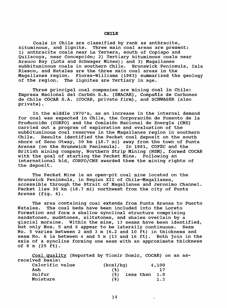
Coals in Chile are classified by rank as anthracite, bituminous, and lignite. Three main coal areas are present: 1) anthracite coals near La Ternera, south of Copiapo and Quilacoya, near Concepcion; 2) Tertiary bituminous coals near Arauco Bay (Lota and Schwager Mines); and 3) Magallanes subbituminous coals in southern Chile. Brunswick Peninsula, Isla Riesco, and Natales are the three main coal areas in the Magallanes region. Flores-Williams (1983) summarized the geology of the region. The lignites are Tertiary in age.
Three principal coal companies are mining coal in Chile: Empresa Nacional del Carbon S.A. (ENACAR) , Compafila de Carbones de Chile COCAR S.A. (COCAR, private firm), and SCHWAGER (also private).
In the middle 1970's, as an increase in the internal demand for coal was expected in Chile, the Corporacion de Fomento de la Producci6n (CORFO) and the Comision Nacional de Energia (CNE) carried out a program of exploration and evaluation of the subbituminous coal reserves in the Magallanes region in southern Chile. Results identified the Pecket coal deposit on the south shore of Seno Otway, 30 km (18.7 mi) away from the town of Punta Arenas (on the Brunswick Peninsula). In 1981, COPEC and the British mining company, Northern Strip Mining (NSM), formed COCAR with the goal of starting the Pecket Mine. Following an international bid, CORFO/CNE awarded them the mining rights of the deposit.
The Pecket Mine is an open-pit coal mine located on the Brunswick Peninsula, in Region XII of Chile-Magallanes, accessible through the Strait of Magallanes and Jeronimo Channel. Pecket lies 30 km (18.7 mi) northwest from the city of Punta Arenas (fig. 4).
The area containing coal extends from Punta Arenas to Puerto Natales. The coal beds have been included into the Loreto Formation and form a shallow synclinal structure comprising sandstones, mudstones, siltstones, and shales overlain by a glacial moraine. Within the mine, 13 seams have been identified, but only Nos. 5 and 6 appear to be laterally continuous. Seam No. 5 varies between 2 and 3 m (6.2 and 10 ft) in thickness and seam No. 6 is between 4 and 5 m (13 and 16 ft) . Both join in the axis of a syncline forming one seam with an approximate thickness of 8 m (25 ft).
Coal quality (Reported by Tiomir Domic, COCAR) on an as- received basis:
Calorific value (kcal/kg) 4,100 Ash (%) 17 Sulfur (%) less than 1.0 Moisture (%) 1.3
14

NvT7^ok ai; *^ v*v-
e^y-JO
O
H03^
XJJ?
' 3*<
<«A
t ^ c~
Vs
IK
2!'
\ e
? L:
n _ §?M
?M ^
i|j«h2
^^,
«a * <» « a <
LS
ZX
^.S
£
\-\
%-
;-- "" >A ««:-^
0^v>
C.v
'-J S
-^
t^^V
2V
^<
/P
V^
4-- 5
( 35
V;\
" ,A
£
,,|o
O
P W
.J5 V
.. ...-- " »
tO
V /'«*>>
^fe
^^'^
!)'}) ^
>^X
-J
^ *.>
. ftj
f
V
If
.- ;/* V
,
^ r f/v^ "r /y
^x^
^.:<./^fc^ (^^'<r\
ri^2.? rV
s \-\^^s'^v
^f^
f^^ l^
^v-^
4^1
x^S
aC
^V
^*-'^
, .--?./-i:-^'V
P^
^V
"'v/
"'^ fe
-^H
f^*:?
rfe
c
o r CD
<Da
;enO)c.roCOroO)
toa>ca;
UJO)
to o
a.
oS-
Q.
a> j^ uO
)D
_O)
O)
O ^o
c
o cO
)
u
o^J-
OJZ3cn

The demand for an increase in coal production in Chile is mainly due to the incorporation of boilers designed to burn coal in the thermoelectric power plants of Codelco-Chile in Tocopilla (northern Chile). To meet its requirements, the Tocopilla Power Plant made industrial tests of different domestic coals, which, in the case of the Pecket Mine, meant carrying out a pilot mining operation in 1984 and the delivery in Tocopilla of a sample of 42,000 tons of coal. Based on the results of the analyses, and through a subsequent bid in 1985, Codelco/Chile and COCAR signed a contract for the supply of 880,000 tons of coal per year for a period of 10 years. Pecket also supplies coal to the thermoelectric power plant of Chilectra in Ventannas as well as to cement plants. COCAR also is in the process of mining gold and iodine in northern Chile.
Six other coal mines are present on the Brunswick Peninsula but none have been mined recently. On Isla Riesco, three inactive mines are present. A concession is presently awaiting operation by ENACAR. Near Natales, ENACAR is currently mining coal from their Dorotea Mine in the same formation as the Rio Turbio coalfield in southern Argentina. Broken Hill Properties (BHP) also has a mining concession near Natales, but no mining is currently underway.
ENACAR currently has four bituminous coal mines in operation in the VIII Region, south of Concepcion: Lota, Colico, Trongol, and Lebu.
Lebu Mine is located 150 km (93.7 mi) south of the coast town of Concepcion. It is underground and has a long history of technical mining problems. In 1984, a concentrated effort was made to modernize operations. To date, all that is lacking is a new analytical lab and coal treatment facility. The coal is Middle Eocene in age from the Trihueco Formation.
Trongol Mine is 100 km (62.5 mi) south of Concepcion, with a similar underground operation as Lebu and mining the same beds as the Colico Mine. Access is through two ventilated shafts: one shaft for personnel, coal, overburden, and air ventilation; the second as a return air ventilation shaft. Coal is removed through a conveyor-belt system.
Colico Mine is located near Curanilahue, approximately 100 km (62.5 mi) south of Concepcion. Coal is mined underground to depths of 400 m (1,600 ft). A new air shaft has been installed recently and the operation probably resembles the two previous mines.
All the coal from these three mines is trucked to the Lota Mine where the coal is washed, sized, analyzed, and driven to its final destination. None of these mines are very large. The coal is Lower Eocene in age and is part of the Curanilahue Formation.
Lota Mine, the most important mine due to the level of production and reserves, is located on the Pacific coast (Bay of
16

Arauco), 540 km (337.5 mi) south of Santiago and 39 km (24.3 mi) south of Concepcion. To visit Lota, one must fly to Concepcion and drive south. There are no hotel facilities in the ENACAR company town of Lota. One either stays as a guest in the ENACAR guest house or commutes from Concepcion.
Two main shafts ventilate the underground/undersea mine. All underground operations are powered by electricity including the operation of the coal carts which have a capacity of 4,500 liters. Maximum number of carts on a coal train is 40. Longwall mining is currently in operation between 480 and 650 m (1,500 and 2,080 ft) below the Arauco Bay using a continuous miner. The main air/elevator shaft starts at the shore and descends approximately 1,000 m (3,200 ft). Personnel and coal carts exit through the different elevator shafts. Three main coal beds are being mined: lower bed 1.2 m (3.94 ft) thick (400 m (1,300 ft) below sea level), middle bed 1 m (3.28 ft) thick (40 m (131 ft) below sea level), and the principal Manta Alta 1.8 m (6 ft) thick (10 m (33 ft) below sea level).
The high-volatile A bituminous coal recovered in the Lota Mine occurs in the Lower Eocene Pilpico Formation. All coal analyses are performed in the analytical lab at the mine site and personnel follow ASTM analytical procedures. Coal is washed, sized on-site, then trucked to its eventual destination. The smallest, almost powder-like size coal is sent to the thermal electric power plants nearby. Coal is shipped on an as-needed basis in vessels supplied by contractors. The bay is shallow, so it needs to be dredged often, and it is a tricky operation loading the boats. Cement plants in Calera and Quilloca burn the Lota Mine coal. Local fishing industries and sugar refining plants also use the coal.
ENACAR is part of CORFO. Because ENACAR had purchased two abandoned mines on Isla Riesco, CORFO granted them permission to have the mining rights to an area that was up for sale just south of the two mines called Estancia Chirillo Invierno. I gather a company has to show an "interest" in an area for CORFO to grant them a mining lease, so this probably explains ENACAR's purchase of a few abandoned mines. Some holes were drilled and logged by the national petroleum company, but the planning was not organized to properly assess the limits and extent of the coalfield. ENACAR did express an interest in receiving assistance from the USGS in helping them assess their coal resources on Isla Riesco, as well as helping them develop an open-pit mine with the eventual production capacity of 2 million tons annually.
SCHWAGER is a private coal company which used to belong to ENACAR. The Schwager Mine is located on the Bay of Arauco north of the Lota Mine. The Schwager operation is similar to ENACAR's in Lota and both are mining the same formation and beds. Weaver did not visit the Schwager Mine, so is unclear as to whom they sell their coal. Due to the extent of local faulting, the two mining operations do not connect undersea.
17
R A Z I L
J U N I\N axjroya
HuanceyoI F I C
lnlerr.zlior.il bcundtry
Depirlimen'.o boundary
0 Nitior.il ctpi'.tl
©. DeptrUrnento ctpital
Riilrosd
Rojd
AREQUIPA
Co-'/ao » f/ic <ca:y o r.^r.-rL-t.V.sl t'«.' C:"::; .-.l..t.«
100 200 Kilometers :cc :<r.s'V tc i* jrc-r. or. i.
Bzs* 37307 2-64 18

PERU
The principal coalfields in Peru are located in the central and northwestern part of the country. Tectonism and severe folding of the strata along the western Andean Mountain front have complicated the lateral correlation of the coal beds as well as affected the quality of the coal. Mining the coal from the top of an anticlinal fold has often stopped exploration of an area and rendered it uneconomic, primarily from a logistical and access point of view. Coal in Peru ranges in age from Paleozoic to Tertiary. North of Lima, all the coal is found within the Goyllarisquizga Group of Cretaceous age. South of Lima, the nomenclature changes and reports indicate coal in the Farrat, Carhuaz, Santa, Chimu, and Oyon Formations. On occasion, the term Santa Formation is used north of Lima.
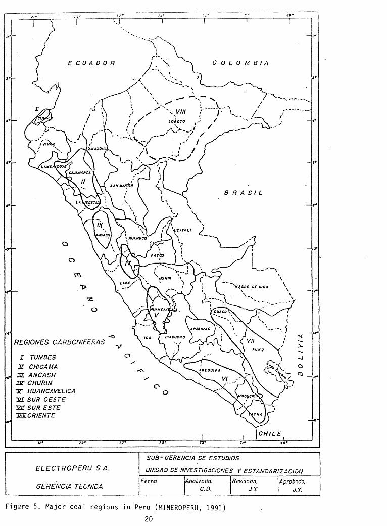
Figure 5 was provided by ELECTROPERU, S.A. and shows the location of the eight coal regions in the country:
I Tumbes ligniteII Chicama anthraciteIII Ancash anthraciteIV Churin bituminous-subbituminousV Huancavelica bituminous-subbituminousVI Southwest bituminous-subbituminousVII Southeast bituminous possibly Paleozoic ageVIII Orient lignite
The five main coal areas are:
Goyllarisquizaa Mine, REGION IV, is 30 km (18.6 mi) north of the city of Cerro de Pasco. Subbituminous coal mined by the Cerro de Pasco Corporation was used entirely to produce coke for the metallurgical operations of the corporation. This mine was in use from 1903 to 1971. It then became uneconomical to mine the coal and the operation shut down. During this period, 8,800,000 metric tons of coal were mined. In 1978, Centromin reopened the mine and currently produces coke for the lead industry. The coal is mixed with coal imported from Pennsylvania. Eighty-five percent of the Peruvian coal mined comes from this mining operation.
Jatunhuasi Coalfield, REGION V, is 70 km (43.7 mi) south of La Oroya and 370 km (231.2 mi) east of Lima. Six coal beds occur in the eastern limb of a broad syncline, but due to the regional tectonism, only two are considered minable. This coalfield was originally mined through shallow workings. Recently, it has been worked on a large scale by the Cerro de Pasco Corporation and the field is considered to have the same resource potential as that of the Goyllarisquizga field. The coal is shipped to La Oroya for coking.
19
COLOMBIAECUADOR
ELECTROPERU S.A.
GERENCIA TECNICA
SUB- GERENCIA DE E STUDIOS
UNIDAD DE INVEST1GACIONES Y ESTANDARIZACIGN
Fecha. Anolizcdo. G.D.
Revisodz. J.Y.
Aprobodo. J.Y.
Figure 5. Major coal regions in Peru (MINEROPERU, 1991)
20

The Ovon-Checras Coalfield, REGION IV, extends 10 km (6.2 mi) north of Oyon to 10 km (6.2 mi) south of Parquin. The coal varies from true anthracite to medium volatile bituminous. Sulfur content is low. The area most explored is the Conocpata deposit, near Oyon. From 1943 to 1946, this mine was controlled by the Banco Minero Peru, with the Polish firm KOPEX, and coal produced was used for coking in Lima and other cities. Mining operations have ceased but coal analyses showed 16.3 percent volatile matter, 66.2 percent fixed carbon, 16.0 percent ash, and 1.2 percent sulfur. Possible recoverable reserves are as much as 8 million tons, but with the steeply dipping beds (greater than 40 degrees), it has proven uneconomical to continue operations.
Alta-Chicama Coalfield, REGION III, is in the northern part of the anthracite field and has been studied by the Servicio de Geologla y Minerla (INGEMMET). Potential reserves are estimated at 200 million tons but local estimates are considerably smaller. Little work has been done to evaluate the true potential of this field. Fixed carbon varies from 80 to 90 percent and volatile matter between 2 to 10 percent. Ten coal beds were identified.
The Santa River Valley. REGION II area, has been studied off and on due to its proximity to the Chimbote steel mill and port. The coal beds are folded and faulted and the coal is deeply weathered and is difficult to recognize at the surface due to the residual ash. Fixed carbon is 75 percent, volatile matter 4 percent, ash 16 percent, and sulfur 1 percent. Four mines are present in the area (Galgada, Ancas, Limena, San Carlos) and maximum resources for the area have been estimated at 50 million tons. The reserves presently are considerably less than the estimated resources because of the low level of detailed exploration.
Geologists from MINEROPERU provided valuable, detailed data on the geology of the principal sedimentary basins, such as Oyon, Goyllarisquizga, and Jatunhuasi. Coal studies also address the three principal regions: North, South-Central, and East. A summary of the latest coal resource estimates by rank is shown on table 2.
ELECTROPERU has been interested in coal as an alternative energy source for approximately the last 65 years. The principal goal of the ELECTROPERU's Carboelectric Program is to study the possibilities of using in-country coal to generate electricity. Current capacity is 60 megawatts and they hope to expand the capacity. The three main goals are the following:
1) to expand the knowledge of coal utilization through generation of electricity
2) to establish other carboelectric plants in high profile or high use areas (Santa and Tumbes regions)
3) to refine the study on coal utilization; to examine other options for in-country use of coal.
21

TiPO
LIGNITO
ANTRACITA
BITUMINOSO
TOTAL
RESERVAS / TM
PROEADO - PROBABLE
31 7 '524, OOO
6 ! 188,OOO
323' 7 12, 000
POSIBLE
100'000,CCO
*
456'825,000
70 ! 000,OOO
120 ! 825,000
POTENCIAL
1 ,106'OOO,000
115'OOO,OOO
1 ,221 'OOO, OOO
TOTAL RESERVAS Y POTENCIAL* 2 , 171 '537, OOO TM
Table 2. MENEROPERU's coal reserve estimates (MINEROPERU, 1991).
22

In 1978, ELECTROPERU along with Universal Engineering (Swiss company) conducted a pre-feasibility study on the possibility of installing an $8 million thermoelectric plant near Chimbote (fig. 6) . The project concluded that the plant would not be a success. Following an evaluation of why the project was not feasible, ELECTROPERU has contracted geologists from INGEMMET (Peruvian Geological Survey) to study the anthracite coal area of Chimbote again. This study is on-going and it will be interesting to see the outcome. The future of projects such as this also depends on the policies of each new Minister of Mines and Energy. Peru is currently awaiting its new Minister, but ELECTROPERU geologists, regardless of any change in policies, plan to continue regional geologic assessments to see what options are available for coal utilization. Cogeneration is also being investigated for use in thermal power plants. MINEROPERU and ELECTROPERU are investigating a thermal-electric energy plant near Alto Chimaca. Mine plans to develop 4,000 tons of coal/day to be used to fire a 480-megawatt thermal electric plant.
Dr. Carlos Soldi, a professor at the Catholic University in Lima, is one of the most knowledgeable individuals on Peruvian coal deposits and coal utilization.
During World War II, Peru exported anthracite to Argentina in exchange for wheat. This trade agreement concluded at the end of the war. Peruvians were aware that they had coal, but there was always a problem on how to make the anthracite burn. Engineers would travel to Colombia and Chile where they would see "coal" shoveled into furnaces, and burn. Furnaces would be purchased at great expense, transported, and set up in Peru and once again, the coal would not burn. This explains why, for a long time, coal in Peru was considered "bad coal".
This all helps to explain why ProCarbon was created in the early 1980's. US Agency for International Development helped fund a 10-year study (1980-1990), for ProCarbon to seriously evaluate the economic potential and utilization of coal in Peru. ProCarbon consisted of scientists from MINEROPERU (25%), ELECTROPERU (25%), and COFIDE (50%). It is still unclear who COFIDE is and if CENTROMIN was ever involved. Dr. Soldi headed the study and he visited countries that are using anthracite West Virginia (USA), China, Korea, and possibly Vietnam. Briquetting machines were being used in China with great success in the domestic as well as in some industrial sectors. Dr. Soldi recognized that the market, back in Peru, would be small at first, so he purchased one machine for $5,000 dollars and had it installed in Huaraz (north of Lima). Briquettes were made and sold to people in the valley between Caraz and Ricuay. The coal used in this pilot study was mined from Huallanca. Pamphlets were distributed to the local population explaining how the briquettes worked and emphasized the need to stop cutting down the trees as a source of fuel. The idea was well received and word spread to Lima. Even today, two brick factories are using the briquettes to supply energy to the kilns. The factories purchased their own briquetting machines. Clay was used as a
23

N
^V Ulna Limtna
fna Son Carlos
N
^HUALLANCA Hfdrefttctnca]
Figure 6. Area being investigated by ELECTROPERU for a coal-fired electric plant (Petersen, 1983)
24

binder to make the briquettes. The fishing industry was approached to use the briquettes, but they produced their own oil which serves as inexpensive energy. Dr. Soldi also addressed the use of coal gasification. A steam-generating process was set up in lea (south of Lima), where steam from the briquettes helped clean bottles at a local mineral-water bottling plant.
This project went well, but the overall success fluctuated with the price of oil as well as with the lumber industry. Since the ProCarbon study was only funded for 10 years and there was no infrastructure set up to continue it past 1990, the study has been terminated. Alberto Manrique, a private consultant who was trained by the USGS in the early 1960's(?), also contributed to this study. It was surprising how much work has been done by ELECTROPERU, MINEROPERU, and ProCarbon in the study of coal utilization. Potential and desire are present to utilize coal in-country, but more work needs to be done in individual coalfields in order to accurately delineate the fields and assess the resource potential. Power plants are a valid option but studies should evaluate the best location for them because in-country transportation costs are high.
25

Ecuador
GALAPAGOS tSLANDS

ECUADOR
Coal in Ecuador has not been extensively studied. The most complete information can be found in an article by O'Rourke (1983), as well as in the OLADE (1984) volume.
The coal deposits of southern Ecuador are in remnants of Tertiary basins perched at 600-900 m (2,000-3,000 ft) in elevation. The known seams are exposed in narrow, faulted belts of steeply dipping, shattered rocks. Some coal beds are as thick as 5 m (16 ft), and some may also contain a fair amount of pyrite, shale, and bentonite. There are three main coal basins (fig. 7):
Malacatos Basin (35 km (21.8 mi) south of Loja) contains coal beds as thick as 2 m (6.5 ft) that are lenticular and are not laterally continuous because of regional faulting. Mining is mainly done by pick and shovel. Resource estimates range from 712,500 to 3,290,000 metric tons. Ash content is reported at 15 percent, sulfur 8 percent, and moisture at 2 percent. The coal is used only for local consumption.
Loia Basin contains coal beds ranging from 1 to 2 m (3.2 to 7 ft) thick, and were mined from small entries. Resources range from 593,000 to 3,780,000 metric tons. Samples from the best seams show a 9 percent ash content, 8 percent sulfur, and 11 percent moisture.
Canar-Azuay Basin (Azoaues-Biblian) centers around and slightly north of the city of Cuenca. The two principal coal seams are found in an interval of clastic sedimentary rocks, mainly shale, siltstone, and bentonite. The coal deposits have traditionally been grouped into a 50-m-thick (170-ft) zone where the two principal lenticular beds are 2 m (7 ft) and 5 m (16 ft) thick. The thin seams are lignitic, whereas the thicker beds are bituminous. The area best developed is near the town of Bibllan 20 km (12.5 mi) north of Cuenca. The ash content reaches 41 percent in some samples. This could be lowered through washing because there is a lot of shale and bentonite in the mined sequence.
The coal in Ecuador has never been used in any major industry. Many studies were made in the 1950's and 1960's by French and German groups, but no importance is currently being given to coal in Ecuador as an alternative energy source.
It should be noted that OLADE is based in Quito. In 1984, they published a detailed and comprehensive study on coal in countries not actively mining and utilizing coal within Central and South America. Discussions with Dr. Razo and Dr. Castillo led to the idea of the USGS and OLADE possibly hosting a workshop in Quito. The principal focus would be coal utilization and environmental aspects associated with the utilization of coal in South American countries.
27

80
100 200
Figure 7. Coal basins in southern Ecuador. Basins are shown with the dashed lines (O'Rourke, 1983)
28

ColombiaCARIBBEAN SEA .
Bonfire? : ' . i;'" ~
C*fU« t»Und« o( In* ArenipUhgo *» /-' ; $40 Andt*» jrProvioVi«i. %_ .. ... ._
nd W. d* Mrfp«te(3'5e'N ei'SSW) brtjng ^^ijtgd to CokimtM but »n not (hewn on this mtpL
>x \ A.*,.^ \ALKS.J i ?^r:r^
E C/U A\D O
0;<6< 1-76 (S41386) Ltmben Contormti Projection
pxtliels 9*15' tnd 0'<5'
Scde VG.OOO.OCO Bou
i Airport '

COLOMBIA
Colombian coal deposits are the most extensive in Latin America (fig. 8). The coals range in age from Maastrichtian- Paleocene in the Eastern Cordilleran basins to middle Oligocene in the western Cordillera, and range in rank from lignite to meta-anthracite. Some of the bituminous coal is suitable for the manufacture of metallurgical coke. Over 80 percent of all the coal mined in Colombia is exported to Europe, the Caribbean region, and some to the United States (table 3).
The El Cerrejon Norte Coal Mine is the largest coal mine in South America and currently produces 12 million tons/year with a projected capacity of 15 million in the near future.
In October 1975, the Colombian government openedinternational bidding for development of the Cerrejon-North Zone coal reserves. Seventeen international companies were invited to present bids. INTERCOR, an EXXON affiliate, was one of the five firms that made an offer. In December 1976, INTERCOR and CARBOCOL, the Colombian government coal company, entered into an association contract for the development and mining of the North Zone. CARBOCOL and INTERCOR are equal partners in the mine, sharing investments, expenses, production, and benefits, with INTERCOR as the operator.
The Cerrejon coal deposit is located in the northeastern part of the country in the Guajira Peninsula, approximately 100 km (62,5 mi) inland from the Caribbean coast (fig. 9). The deposit is found in the northern portion of the basin between the Cesar and Rancherla Rivers. The basin is a narrow valley bounded by the Sierra Nevada de Santa Marta on the west and the Perijci Mountains on the east. Coal deposits extend 50 km (31.2 mi) along the Rancherla River valley. The North Zone covers nearly 300 sq km of relatively flat terrain. The mine is connected to the port (Puerto Bolivar) by a 156-km-long (97.5-mi) railroad built specifically to transport the coal. Two trains, of 100 cars each, make the daily round-trip from the mine. The Central Zone is the smallest of the three zones and covers 100 sq km. Current production from the zone is about 500,000 tons annually. The South Zone, nearly 300 sq km, is not being mined.
The coal-bearing Cerrejon Formation is a transitional marine-continental deposit of Paleogene age (25-55 million years old). It averages 900 m (2,900 ft) in thickness and consists of dark-gray claystones, siltstones, and black shales. Numerous coal beds occur with thicknesses ranging from a few centimeters to as much as 10 m (32 ft). Approximately 40 major economically recoverable seams have been defined within the North Zone. Their distribution and lateral continuity makes them appropriate for large-scale open-pit mining operations. Seam thickness averages 3 m (10 ft) and ranges from 0.7 to 10 m (2.3 to 32 ft); average dip is 14 degrees.
30

Figure 1.
COLOM B I A
Coo I Basins
Figure 8. Coal basins in Colombia (Suescun-Gomez, 1983)31

ze
IO
O 0> O> C_i.-$ o cr -s o=3 -O fD OCO -$
c+O. <S> (D-" Oi
rsO CLo>-$ -$-j. O>cr -j.(D *
- o>00 <<
> to- *<
V (/)
^rr _i.o
=3 -h
(D=3 O
O O
o3 cr
Oo
n> x-a o-$

( International Coal Report
Colombia's coal exports 1991-19951
Source
Cerrejno Norte
Carbones del CaribePuerto Liberatador
i La Ja(uaOrefanalTotal CdC
Prodecofrom existing sources"CateoluritasCerrejoo CentraleToUl Prodeco
DrummondEl Boqueron
Others
TOTAL COLOMBIA51
!?91 1992 1993
13.8 14.0 1S.O
0.3 0.5 0.51.2 1.5 2.0
0.3 1.01.5 2.3 3.5
0.5 0.5 0.50.5 1.0
0.2 0.~S 1.50.7 l. IS 3.0
...
0.5 1.3 2.3
16.5 19.35 23.8
11994 1995
17.0 19.0
0.5 0.52.0 2.02.0 3.0 i4.5 5.5
0.5 O.S1.5 2.02.0 3.S4.0 6.0
1.0 2.0
2.3 2.3
29.2 24.8
!2 Stecm coal from La Jcgua oniy. Prodeco alto exports coke end coking coal 1 totalling some 25GjDOOt cnnucily.
Colombian Coal ExportsI' Country
GermanyArgentinaBelgium-LuxembourgBrazilChileDenmarkSpainUSAFinlandFranceGreeceHong KongIrelandUraelItalyJapanHollandPanamaPeniPortugalPuerto RicoUKDominican RepublicSwitzerlandVenezuelaVirgin Isles
Total
Tonnes PriceUSS/C
151.867 47.2461.244 50.0071.779 49.33
270.673 46.89163,117 55.15
2,251,423 39.91419.000 42.58
I.075J6I 41.39317.106 36-42
1,986.682 4! .3350.000 22.75
140.000 34.50846.403 41.45870.000 29.47239,145 38,5621 1, £25 38.18
2, 152. £06 41*2145.500 38.6828.019 100.75
478.701 29.24270,880 45.45
2,843.595 45.8822.182 ?5.36
125.000 29.7327.096 28.75£4,000 29.76
15.203.219 42.56
1990!
I!
i
ii:
ii!
:
; Note While this table may look someu-hat historic it is the latest full da:a S from Colombia.
Source: ICR SO-MCCS
Table 3. Figures on Colombian coal exports- quantity and destination

The Cerrejon Formation has been divided into three parts based on the distribution and thickness of the coal beds in the unit:
1) lower group, 180 m (600 ft) thick, contains coal beds up to 2 m (6.5 ft) thick
2) middle group, 330 m (1,100 ft) thick, contains coal beds from 0.9 to 6.0 m (3 to 20 ft) thick
3) upper group, 400 m (1,200 ft) thick, contains the thickest coal beds ranging from 1.4 to 10 m (4.6 to 32 ft). Coal beds in this group are more widely spaced.
Most of the coal mined is high volatile B bituminous coal. All coal is analyzed at the mine laboratory and again at the port in order to maintain quality control on each shipment. Sampling and analysis procedures follow ASTM standards. A representative coal analysis of the El Cerrejon coal is as follows:
total moisture 11.0 %ash 7.5 %volatile matter 33.3 %sulfur 0.7 %BTU/lb 11,700
The detailed sample analysis can be seen on table 4.
CARBOCOL is planning a pilot test study, to begin in 1993, on the possibility of using coal briquettes for coffee drying, near Antioquia. Briquetting machines from China are proposed for use. A thermal power plant will also be built and the briquettes might also be used in the plant. So far, this is the only plan to use coal in-country as natural gas appears to be the preferred energy option. Deforestation is also an issue where the local population cuts down trees for fuel and then has to face the consequences of landslides and increased soil erosion and depleted fuel supply.
Three private coal companies are exporting coal from Colombia: Carbones del Caribe S.A., Prodeco, and Drummond.
Carbones del Caribe S.A. was established in 1981 by a group led by the Cementos del Caribe S.A. , and was created for a dual purpose: to provide an alternate source of energy for the group's cement plants and to export coal. The company operates Puerto Libertador Mine in the Department of Cordoba; La Jagua De Ibirico Mine in the Department of Cesar; and Oreganal Mine in the Department of La Guajira (figs. 9 and 10) . The coal is trucked to various crushers of Carbones del Caribe located at Zima, near Puerto Libertador, with processing capacity of 1,500 metric tons per day; Santa Cruz at La Jagua De Ibirico, with 2,000 metric tons per day; and Pavas in Baranquilla, with 4,000 metric tons per day. At the crushing site the various coal qualities are piled separately, depending on the size and quality value committed to be shipped to various export markets. Quality analyses are shown on tables 5 and 6.
34

AV
ER
AG
E C
OA
LQ
UA
LIT
Y (
1)19
89-1
993
CE
RR
EJO
N N
OR
TH
ZO
NE
Pro
xim
ate
Tot
al M
oist
ure
%A
sli
%V
olat
ile %
l;ixc
d C
arbo
n %
Sulp
hur
%C
alor
ific
Val
ueM
J/K
j;K
Cal
/kg
irru/
i.b
MJ/K
HK
Cal
/Kj;
irru/
i.i)
I
Initi
al D
efor
mat
ion
Snf
lcui
iiK
tll
= W
)H
emis
pher
ical
(11 - W
/2)
Flui
d
1 1/"*
i1 K
M
l'Cln
et('
l)PC
I gr
oss
(5)
I'SI
l:.<p
iilil)
iium
Moi
slui
e %
Flu
orin
e pp
m
STA
ND
AR
DA
S-R
EC
EIV
ED
Ana
lysi
s
11.3
08.
0033
.40
47.3
010
0.00
0.70
(iro
ss27
.28
(»5I
711
730
Net
Yft.
T)5
6222
1 1
2(X
)
Mis
ion
Tem
per
atu
res
of A
.sh
Red
ucin
g O
xldl
/.iny
K
(""
*\f
*C1
V>
1 V
^
2230
12
21
2330
12
7723
50
1288
24
30
1332
2460
13
49
2550
13
8925
70
1410
20
00
1427
Olh
cr Q
uali
ties
49 311
587
I1/;
. 8.
90 46
CO
AL
BA
SIS
(2)
Ult
imat
e A
naly
sis
(Wci
^lit
%1
Mt)i
Mur
c %
Car
bon
%H
ydro
gen
%N
ilrog
cn %
Chl
orin
e %
Sulp
hur
%A
sh %
Oxy
gen
%
Min
eral
Ana
lysi
s or
A.sh
(Wci
Rhl
% I
gnite
d Ha
xi-s)
Sil
ico,
SiO
; A
lum
iniu
m,
Al^
Q,
'rita
imim
. T
iQ^
Iron
I;c
^()|
C
alci
um,
CaO
M
agnc
siui
u. M
jjOI'o
lnsi
um,
K2O
Sod
ium
, N
a2O
Sul
phur
, SO
^I'l
iosp
horo
us,
I'2O
SU
ndel
erm
ined
Sulp
hur
Form
s
Pyri
tie %
Sulf
jitc
%O
rgan
ic %
Tot
al %
Not
es
(1)
Ana
lysi
s by
A.S
TM M
anda
rtls,
(2)
"As
Rec
eive
d B
asis
" as
def
ined
in
AJJ
TM D
O 1
80(3
) In
clud
es w
ater
cor
rect
ion
(4)
I'd «
(M
GI
* K
Cal
/Kfi
ncl)/
IOO
O(5
) t'C
I »
(1IG
I x
IITU
/Lb
gros
s)/ I
(XX)
11.3
066
.20
4.50
1.20
0.04
0.70
8.00
8.06
100.
00
61.5
0 18
.00
o.yo
8.80
,
2.46
1.
601.
800.
802.
800.
300.
3010
0.00
0.28
0.08
0.34
0.70
Tabl
e 4.
Co
al qu
alit
y fr
om th
e El
Cerrejon Norte
Zone (C
arbo
col,
1991)

DIS
TA
NC
ES
KM
S
fTO
. L
IIC
ftT
AD
OK
MIN
A -
Z
IM 8
A
ZIN
IA.
CA
UC
A S
1
A
CA
UC
AS
IA-
CA
RT
A8E
NA
21
MIA
-
TO
LU
19 TO607
2«0
RO
UT
ES
AN
D D
IST
AN
CE
S
JA
«U
A
DC
IIIK
1C
O
JAO
UA
NA
TE
CA
N A
JAO
UA.
TA
MA
LAN
EQ
UC
TAM
ALA
MC
QU
C-
I/Q
UIL
LA
TA
MAL
AHC
QU
E
CART
AOEN
A JA
OUA
- S
ANTA
MAR
TA
JAO
UA-
IA
RR
AN
QU
ILLA
JA
OU
A
CA
RTA
OC
N A
MA
R
CA
RIB
E
PO
RT
OF
SA
NTA
MA
RTA
PO
RT
OF
B
AR
RA
NQ
UIL
U\
0«
E«
AK
AL
- D
AY
PO
nTG
TU
OR
tOA
MA
L.
MA
RA
CA
IIO
PO
RT
OF
CA
RTA
GE
NA
VE
NE
ZU
EL
AT
EC
AfU
K
MA
LA
ME
QU
K
\
RIV
ER
S
RA
ILW
AY
C 0
L
Of
M
B I
A
O
O > o
Figu
re 10.
Loca
tion
of t
he coal mi
nes
oper
ated
by
Carbones
del
Cari
be,
S.A.
(Carbones
del
Caribe,
S.A.
, 19
91)

QUALITY ANALYSIS
TYPICAL QUALITY (AS RECEIVED)
PROXIMATE ANALYSIS
GROSS CALORIFIC VALUE (BTU/LB)
ASH %
SULPHUR %
VOLATILE MATTER %
MOISTURE %HARDGROVE GRINABILITY INDEX
ULTIMATE ANALYSIS (% WEIGHT)'
CARBON
HYDROGEN
NITROGEN
CHLORINE
SULPHUR
MOISTURE
ASH
OXfGEN
PUERTO L1BERTADCR
JAGUA OREGANAL BLEND
10.200
5.0
0.8
38.0
14.0
41.0
12.400
6.0
0.7
36.0
10.0
48.0
12.120
4.5
0.5
36.6
10.0
51.0
11.200
6.0
0.7
37.0
10.0
45.0
58.41
3.97
1.09
0.07
0.80
14.00
5.00
16.66
70.34
4.65
1.14
0.06
0.60
8.00
6.00
9.21
65.00
4.00
1.19
0.03
0.50
10.98
5.50
12.80
64.45
4.35
1.13
0.06
0.70
11.00
7.00
11.31
10C°/< 100% 100% 100%
CHEMICAL ANALYSIS OF ASH
Fe2C3
CaO
MgO
Na20
K20
SiO2
AI203
T02P2O5
SO3
Mn3O4
MnO2UNDETERMINED
10.20
7.60
2.57
0.61
C.42
40.81
21.81
1.20
0.35
11.42
0.08
2.93
3.70
9.20
0.85
0.49
0.93
52.00
20.91
1.00
0.39
6.90
0.04
3.59
12.35
4.40
3.84
2.70
0.35
46.01
22.19
0.93
0.14
6.15
0.13
0.80
5.E3
3.04
0.97
0.48
0.87
54.29
26.34
1.20
0.30
3.79
O.C4
0.02
2.E3
', 00% 100% 100e
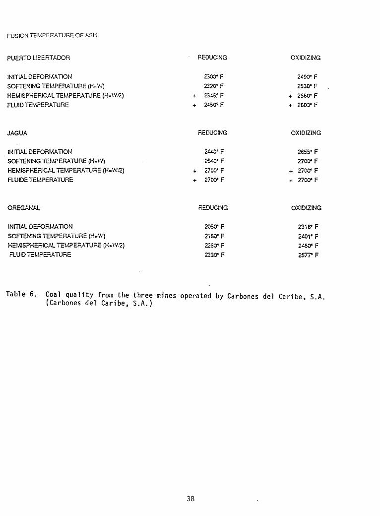
Table 5. Quality of coal from three mines-Carbones del Caribe, S.A (Carbones del Caribe, S.A., 1991)
100%
37
FUSION TEMPERATURE OF ASH
PUERTO LIBERTADOR REDUCING OXIDIZING
INITIAL DEFORMATION
SOFTENING TEMPERATURE (H=\V)
HEMISPHERICAL TEMPERATURE (H-W/2)
RUID TEMPERATURE
2300* F
2220e F
2^50* F
2530° F «- 2560° F
+ 260D°F
JAGUA REDUCING OXIDIZING
INITIAL DEFORMATION
SOFTENING TEMPERATURE (H-W)
HEMISPHERICAL TEMPERATURE (H-W.2)
FLUIDE TEMPERATURE
2700e F
2700* F
2655' F
2700* F
+ 2700° F
+ 270CTF
OREGANAL REOUCWG OXIDIZING
INITIAL DEFORMATION
SOFTENING TEMPERATURE (K-W)
HEMISPHERICAL TEMPEFATURE (H-\V.2)
TEMPERATURE
2050'F
2', SO* F
22EOC F
2330* F
2318* F
F F
Table 6. Coal quality from the three mines operated by Carbones del Caribe, S.A, (Carbones del Caribe, S.A.)
38

La Jagua De Ibirico Mine covers 2,000 acres in the Department of Cesar. The company holds mining rights for the next 20 years, with reserves surpassing 25 million metric tons from open-pit mining and 70 million metric tons from underground operations which targets high calorific value steam coal. The underground mining is relatively new and is done by longwall mining techniques as well as room and pillar systems. As of1993. the eventual goal is for an annual production of 1,000,000 metric tons.
Puerto Libertador Mine covers 49,000 acres in the Department of Cordoba where coal is being mined in an open-pit process. The mine reserves are estimated at 300 million metric tons which guarantees a considerable tonnage for export as well as for the industrial and energy sector in the northern part of the country. Coal is trucked 70 km (43.7 mi) to the port of Caucasia, on the Cauca River, from where it is barged to the seaport of Cartagena or Baranquilla, through the Cauca and Magdalena Rivers and the Dique Channel. During months of low water level, coal is trucked to the seaport of Tolu, located 260 km (162.5 mi) from the mine.
Oreganal Mine lease covers 4,700 acres in the Guajira province. It is just south of El Cerrejon in the Central Block. The mine has not started yet, but the project is expected to generate 500,000 metric tons in 1992, followed by 1,200,000 metric tons in 1993. The target goal is 3 million metric tons in1994. Studies estimate reserves at 70 million metric tons through open-pit mining and 100 million metric tons underground. The deposit has 31 beds with thicknesses ranging between 1 and 5 m (3.2 and 16 ft). The initial pit (open-pit?) will reach 100 m (320 ft) in depth for exploitation of intermediate seams 13, 14, and 15, which provide the most attractive operating ratios for open-pit mining.
Prodeco is a private producer and exporter of metallurgical and steam coal and coke in Colombia. It started operation in 1968 and has developed important mining operations in coking coals in the central zone of the country, 120 km (75 mi) northeast from Bogota, near Lenguazaque and Guacheta. Extracted reserves of over 50 million tons of excellent quality coal have been exported overseas. The coking coalfields (Lenguazaque- Guacheta), as well as the steam coal mines (La Loma-La Jagua), are connected by rail and road with Prodeco's port in Santa Marta. A 30-year contract with Carbocol assures the exploitation of a coal mine in La Loma, State of Cesar (El Descanso Mine), where reserves are calculated at more than 100 million tons of coal, and to eventually produce up to 3 million tons per year. Export of 2 million tons is foreseen for 1992. Prodeco is having a problem locating a port facility for its newly acquired mining concession south of El Cerrejon. Locating a port closer to the mine rather than trucking the coal to Santa Marta is desired, but the coastal waters are quite shallow. Investment cost could be large. Coal quality results are shown on table 7.
39

COKING COAL
(As received)
Moisture %Ash %Volatiles %Sulphur %FSI
Washed Ox 50mm
6.0 Max.8.0 Max.24-26
0.8 Max.7-9
STEAM COAL
(As received)
Moisture % Ash %Volatiles % Sulphur % Calorific Value (GAR)FSIHGIAFT
Rnes Oxfrnm
10.01522
-16-24
0.96 -7
Ox 50mm 0x1 50mm
10.0 Max. 10.0 Max.
34 - 37 11.900BTU/lbMin.
0.8 Max.1.3
45-48+ 2.600 eF
COKE SPECIFICATIONS
(As received)
Moisture %Ash %Volatiles %Rxed Carbon (Dry Basis) %Sulphur %Micum 40Micum 10
tlet coke 30 x 75mm %
6.010-121-2
86-880.9
75-807-8
Foundry + 75mm V.
6.013-14
1 -263-85
0.975-807-8
Pea coke 7 x 30mm V.
7.015-172-4
78-800.9
--
Coke Brezze -7nvr %
8.0-10,022-246-8
68-700.9.-
Table 7. PRODECO coal quality analysis (Prodeco, 1991)
40

Drummond Ltd, is also a privately-owned mining company and is a member of the Drummond Company, Inc., in Alabama. Mine studies and reserve estimates have been made for the La Loma Mine (fig. 11); construction is scheduled to start in 1992 for the mine as well as the start of the railroad to the port city of Cienega (south of Santa Marta). The average quality of the individual coal seams on a dry basis as determined from drilling is summarized as follows:
moisture 9.53 %ash 4.63 %sulfur 0.67 %volatile matter 41.44 %BTU/lb 3,176fixed carbon 53.93 %
Recoverable reserves are estimated at 333.7 million metric tons in the measured category and an additional 165.9 million metric tons currently classified in the indicated category.
Colombia contains the largest coal reserves in Latin America and all coal is exported. Some companies requested assistance in one form or another from the USGS, but it is not possible to engage in cooperative efforts with companies who plan to export coal and compete in the coal market with the US. In contrast to most US mining operations, it was interesting how, in addition to planning and building a mine, companies also had to address building roads/railroads as well as ports.
41

CARIBBEAN SEA
CERREJON>/
CARTAGENA
CANAL DEL DIQUE
PACIFIC OCEAN
COLOMBIA
DRUMMOND LTD.
LA LOMA PROJECT COLOMBIA, S.A
MAP OF COLOMBIA LOCATING Uk LOMA COAL PROJECT
Figure 11. Location of La Loma coal mine (Drummond, LTD., 1991)
42

p c
e^,^r^fS
N J
..Ji:B
,,t,i,n
, \
J'V
^--
- -
5024
8* t
-Jl
(541
398)
l»
mb
«ft
Cen
loim
«l P
rojo
dkM
' S
UnH
*r<f
p..«
nrl
» 10
*00
*nd
7*40
Sr
.Bln
1:8
.000
.000
nn
iinrt
ory
>ftp
rntn
nlA
llnn
It
not
noe
e>k*
rlty
lu
lhor
ltn
llvo
Rai
lroad
Roa
d
Air
port

VENEZUELA
Venezuela ranks second in Latin America in coal resources. The principal coal-bearing areas are in Anzoategui, Falcon, Tachira, and Zulia (fig. 12). Other coal basins or coalfields have been partially examined, but their physical characteristics, structural relations, and commercial volume have not been established. Venezuela is rich in oil, gas, and hydroelectric power. For these reasons, coal is only exported and is not being considered as an alternative energy source.
The existence of coal deposits in Venezuela has been known since the early nineteenth century, when the Naricual mines were developed in the state of Anzoategui, in the eastern part of the country. Venezuelan coal began to secure a place for itself in the international market in 1988. In the 1990's, Venezuelan coal projects have come under a planning, promotional, and developmental policy preparing the ground for future projects.
Total coal resources estimated thus far are 9,159 billion metric tons and proven amount to 514 million metric tons. From 1975 to 1986, peak production reached 120 million metric tons from the deposits in the southwestern state of Tachira. In 1977, when Paso Diablo Mine opened in Guasare, the state of Zulia began to increase coal production and along with production from the Tachira mines, Venezuela had already entered the coal export market. In 1992, Carbones del Guasare, S.A., plans to expand production in the Paso Diablo Mine to 3 million metric tons per year.
The Andean Region
Three mines Lobatera, Rubio, and Santo Domingo are located in the state of Tachira in southwestern Venezuela. The coal potential for the region is about 1.5 billion metric tons and covers the three deposits. Tachira ranks second in the country for coal production. Coal is used for thermal as well as coking purposes, uses which suggest how it will be used in the industrial sectors. The coals from this region are targeted for steam coal and for use as coking coals. Mining production will increase until it reaches its targeted limit of 3.8 million metric tons of coal in the year 2000; 1.5 million of which will be steam coal, 2.3 will be coking coal, and any excess will go towards the installation of processing plants of capacities corresponding to the production program.
Coal quality from the Lobatera Mine: calorific value Kcal/Kg 6,360 ash % 18.8 volatile matter % 46.3 sulfur % 0.9 free-swelling index 4
44

Ul
Car
ibbe
an S
ea
1 G
uasa
rc,
Zul
ia2
Gua
rico
, N
oror
icnt
al3
Ara
gua,
Mer
idio
nal
4 N
aric
ual,
Anz
oalc
gui
5 L
obat
cra,
Tnc
liirn
6 Sa
nlo
Dom
ingo
, T
aclli
ra7
Rub
io,
Tac
llira
8 Fa
lcon
Ccn
tro-
Ori
cnta
l
225
KM
Figure
12.
Mador
coal
fiel
ds in Ve
nezu
ela.
Dashed lines
represent
department bo
unda
ries
.Coa
l de
posi
ts
are
numb
ered
with
thei
r re
spec
tive
department
foll
owin
g (M
oddf
ied
from R
odriquez,
1986
).

Eastern Region
Two coal mines are present in the state of Anzoategui: Naricual and Fila Maestra.
Naricual mines, with an areal extent of 25 km (15.6 mi), are located in the northern portion of the state, near the town of Barcelona. The Tertiary coals are in the Naricual Formation, and two principal coal beds are targeted in the mining operation. Naricual has a long history of unsuccessful mining ventures. Recently, a British firm, Young Group PLc, along with a local company, decided to reactivate the mines and extracted 7,500 tons per month in 1991 through an open-pit mine. Evaluations of the deposit are still underway to decide the future of the operation.
Fila Maestra Mine is an open-pit operation which produces steam coal for export. Exploration started in 1983 through surveys obtained by CAVOVEN to Corporacion para el Desarrollo de la Regi6n Oriental (Venezuelan Corporation for the Development of the Eastern Region). In 1984, a pre-feasibility study was successfully completed and the deposit was considered economic for the export of steam coal. Estimated reserves are 14 million tons and resources over 65 million tons. This last figure is expected to increase with continued exploration. The coal is exported through Puerto Guanta, a deep water port 100 km (62.5 mi) from the mine. The present level of production is 240,000 metric tons per year with a target level of 500,000 within the next few years. Results of coal quality analyses:
calorific value Kcal/Kg 11,900ash % 9.11moisture % 6volatile matter % 39.40sulfur % 1.3
The northern Aragua State is in the preliminary geologic survey stage. Its level of reserves is projected in the 20 millions, but to date no mining or in-depth evaluations have been made of this deposit.
The northeastern portion of Guarico State contains coal but no evaluations have been made of the deposits. The area is geologically complex and contains numerous folds and extensive faulting.
Falcon Coal Basin
The state of Falcon is located in the northwestern part of the country. Reserves for an open-pit mine are estimated at 40 to 50 million metric tons within an area of 140,000 hectares. This mining concession is still(?) in the bidding process and results of on-going assessments of the coal will decide how the coal will eventually be used. The initial estimates are for a starting production of 200,000 tons per year; an intermediate stage of 1 million tons per year would be reached for 1995 and 2 million tons of coal annually by the year 2000.
46

Reported quality of the Falcon coal:-volatile matter % 43.1 to 44.4-fixed carbon % 45.6 to 48.6-ash % 5.1 to 6.5-sulfur % 0.3 to 2.0-humidity % 4.3 to 7.1-BTU/lb 12,500
Zulia State Coal Basin
The Guasare basin contains the most important coal deposits in Venezuela. It is located in the northwestern part of the country, almost due east of the El Cerrejon coalfield in Colombia. The Guasare coal basin extends 50 km (31.2 mi) north- south and is about 3 km (2.5 mi) wide. The deposits are in the foothills of the Sierra de Perija and are in the Manuelote syncline. Based on regional drilling, resources for the deposit are estimated at 8,500 million metric tons of bituminous coal. Additional exploration has demonstrated that there are over 600 million tons of recoverable coal from 11 groups of seams; each seam varies in thickness from 1 to 13 m (3.2 to 42 ft). Quality of the Guasare coal:
-calorific value BTU/lb 12,650-sulfur % 0.6-ash % 7.5-volatile matter % 34.5-fixed carbon % 51.0-moisture % 7.0
The calorific value and low ash and sulfur contents make it a premium coal for thermal use. This coal can also be used for metallurgical purposes for direct injection into blast furnaces as a substitute for coke.
Three mines are present in the Guasare basin, only one of which is currently being mined. In 1986, Carbozulia (a subsidiary of Petroleos de Venezuela, S.A., the Venezuelan government energy organization) was assigned the mining concession.
Paso Diablo Mine operates under Carbones del Guasare, a joint venture between Carbozulia and Agipcoal from Italy. Marketing of the coal is through Guasare Coal International. In 1992, production was around 3 million tons per year. A projected figure for 1998 is for 10 million tons per year. The coal is mined in an open-pit and trucked to a port just north of Maracaibo. A new port is scheduled to be built at some point in the near(?) future north of the port currently in use. Trucks currently haul the coal to the port loading area where the coal is washed, sized, and loaded on the ships.
47

Socuy Deposit, located south of the Paso Diablo Mine, is in the exploration phase with field investigations, shallow drill holes, and geologic interpretations being used to assess the potential of the 4,300 hectares deposit. A 7.5-million-ton-per- year development is scheduled. The estimated reserves are 250 million metric tons. Carbozulia, Shell Coal International, and Veba Oel are the mining partners.
The Mina Norte Mine, north of the Paso Diablo Mine, is barely into the field investigation stage. Preliminary reserves are estimated at 335 million metric tons. It is estimated that some 65 million tons of these could be mined from an open-pit and some 81 million tons by underground mine, totalling more than 146 million tons. Exploration is projected for 20 months with 10,000 m (32,500 ft) to be drilled. If estimated reserves and economic feasibility are proven, a project of 1 to 4 million metric tons per year will be launched.
Iniciarte and Cachiri Mines are being promoted on the international coal market to attract prospective partners for the exploration and exploitation of the coal. The geology is complex in the Cachiri Mine due to extensive faulting.
Marketing of Venezuelan Coals
The primary market for export is Europe, primarily for utilities, cement plants, and sized-coal consumers. Secondary outlets are the USA (utilities), Central America and the Caribbean region (utilities, cement plants), and South America and the Far East (utilities, blends) .
48

frV
suR
iNA
/A I
FR
^CA
YE
NN
E
CF f S
UR
INA
M
GU
|A^
/ il
' S
R<l
A H
'
"
Bas
e 76
707
7-69

BRAZIL
Five coal-bearing regions are present in Brazil (fig. 13): Upper Amazon Region (I), Rio Fresco Region (II), Tocantins- Araguaia Region (III), Western Piaul Region (IV), and Southern Brazil Region (V). Regions I, III, and IV all contain lignite deposits without economic potential. Lignite beds, averaging 1 m (3.2 ft) in thickness, have been present in oil and gas drill holes. Some anthracite-like coal beds were noted in Region II but the beds are less than 1 m (3.2 ft) thick and these deposits were judged not economic. All presently economic deposits in Brazil are found in the Southern Region (V).
Coal in southern Brazil represents 99 percent of the country's known economic coal deposits. Deposits are located in the states of Parana, Santa Catarina, and Rio Grande Do Sul. Fourteen coal mines are shown on figure 14; most of these are presently in operation but production of coal over the past few years has started to diminish. Coal in the region is used in thermal electric generating plants or as metallurgical coal. In a few cases, coal was used both in the steel industry and for the production of gas. The coal is very high in ash. Subsidence is a problem in the mining region, probably associated with the underground mining operations.
An extensive 20-volume report has been compiled on the coal in the southern states entitled Borda L'Est. Due to time constraints, only detailed geologic maps of the mining regions, showing the mine locations, were obtained.
My overall impression is that coal is being used to supply local power plants, but due to the high ash content, it has not proven very economical to try to increase local or regional use.
50

PERNAMBUtO7Recife!
9 E JANEIROl 6i
Rio c« Janeiro.*, ~ FA R A fASo Poul
Upper Amozonos Region .... I
Rio Fresco Region
Tocantins-Aroguoia Region . . HI
Western Piauf Region ..... . ]V
Southern Brazil Region . . ...
Coal Outcrops
SCALE
0
Figure 13. Major coal regions in Brazil (Machado, 1983).
51

GEOtocic S
QUATERNARY SEDIMENTSE
LAVA FlO^S &' * v
SEDIMENTS
DEVONIAN SEDIMENTS
SHIELDS
SCALE
0 50 IQQ |5Q
KM
Coal Mines: I Candiota H Hulha Negro HI Sao SepeIV IruiV Leao-ButiaVI Arroio Dos Ratos VTL Charqueadas \TH Gravatai DC Santa CatarinaX Rio TibagiXI Rio Do Peixe XH IbatiXHl Wenceslau Braz XTV Barbosa
Figure 14. Geologic sketch map of southern Brazil showing the major coalfields (Machado, 1983).
52

Bolivia
507^40 1-7 6
Lambert CoMo"nal Projection StanCc'd parallels 12*00' a»c 20*30' Scale l:e.SOO.OOO
A Airport
53

BOLIVIA
Economic coal deposits have not been reported in Bolivia. The presence of bituminous coal has been known for more than 100 years on the Copacabana Peninsula of the Lake Titicaca region. The natives of the Siripaca and Yampupata Ranches, adjacent to Lake Titicaca, used the coal to fire lime.
The best known anthracite bed is in the Copacabana Peninsula region and on the Isla del Sol, Lake Titicaca. The average thickness is 10 m (32 ft), and the coal bed contains 30-50 percent ash and 0.48-1.3 percent sulfur. Anthracite beds have also been noted in the Chimbota Province (Apillapampa Ranch), but no thickness or quality data have been reported.
Lignite beds are generally thin in Bolivia, and most appear to have a high clay and sand content. The calorific value, according to Flores-Williams (1983), is low with the highest Btu/lb reaching 5,380. Sulfur content is high (6-8 percent). According to ASTM standards, this barely qualifies as a lignite; some would consider this a peat. Tarija basin contains the most important lignite deposits in the country. Thickness of the beds ranges from 30 to 90 cm (12 to 38 in.) and can be seen along the banks of the Rio Tomolosa, 7 km (4.3 mi) southwest of the town of Tarija. The lignite beds appear to thicken and be more laterally extensive towards the south; this may represent one or a series of lagoons present between glaciations. In the Cochabamba basin, lignite beds have been reported and outcrops in the eastern Sabaya basin have also exposed a few lignite beds 5-25 cm (2-10 in.).
So far, the lignite has not proved useful for domestic use or iron manufacturing due to the high sulfur content. It has been used at times for the manufacturing of bricks by the local population.
It would be fair, based on these data, to conclude that Bolivia does not contain coal deposits of economic potential. Detailed investigations should be conducted in the areas where lignite beds have been described to see if there is any potential for mining and utilization of this resource. Bolivia appears to contain peat deposits of unknown quantities. With careful study and evaluation, peat could be mixed with additives and be converted into an alternative energy source for the domestic and possibly industrial sectors. Peat is also currently being used as a soil additive for cultivation in the domestic sector in La Paz. GEOBOL (Bolivian Geological Survey) did express an interest in a possible cooperative effort to assess the country's peat reserves and to try to define its potential uses in-country.
54

SELECTED REFERENCES
Bergmann, F.A.J., 1983, Coal resources of the Argentine Republic, in Kottlowski, F.E., Cross, A.T., and Meyerhoff, A.A., eds., Coal Resources of the Americas Selected Papers: Boulder, Colorado, Geological Society of America, The Geology of North America Special Paper 179, p. 15.
Bergmann, F.A.J., and Xicoy, A.N., 1990, Coal resources ofArgentina, in Ericksen, G.E., Cafias Pinochet, M.T. , and Reinemund, J.A., eds., 1989, Geology of the Andes and its relation to hydrocarbon and mineral resources: Houston, Texas, Circum-Pacific Council for Energy and Mineral Resources Earth Science Series, v. 11, p. 131-137.
Ericksen, G.E., Cafias Pinochet, M.T., and Reinemund, J.A. , eds., 1989, Geology of the Andes and its relation to hydrocarbon and mineral resources: Houston, Texas, Circum-Pacific Council for Energy and Mineral Resources Earth Science Series, v. 11, 452 p.
Flores-Williams, H., 1983, Chilean, Argentine, and Bolivian coals, in Kottlowski, F.E., Cross, A.T., and Meyerhoff, A.A., eds., Coal Resources of the Americas Selected Papers: Boulder, Colorado, Geological Society of America, The Geology of North America Special Paper 179, p. 1.
Machado, E.R., 1983, Coal in Brazil, in Kottlowski, F.E., Cross, A.T., and Meyerhoff, A.A., eds., Coal Resources of the Americas Selected Papers: Boulder, Colorado, Geological Society of America, The Geology of North America Special Paper 179, p. 23.
O'Rourke, J.E., 1983, Coal basins of Ecuador, in Kottlowski,F.E., Cross, A.T., and Meyerhoff, A.A., eds., Coal Resources of the Americas Selected Papers: Boulder, Colorado, Geological Society of America, The Geology of North America Special Paper 179, p. 43.
Organizacion Latinoamericano de Energia (OLADE), 1984, Inventario de Recursos de Carbon Mineral en Paises No Productores de America Latina, Documentos D-PLACE No. 15, 689 p.
Petersen, R.C., 1983, Coal resources of Peru, in Kottlowski,F.E., Cross, A.T., and Meyerhoff, A.A., eds., Coal Resources of the Americas Selected Papers: Boulder, Colorado, Geological Society of America, The Geology of North America Special Paper 179, p. 35.
Rodriquez, S.E., 1986, Recursos Minerales de Venezuela, Boletin de Geologia: Ministerio de Energia y Minas, v. XV, no. 27, 228 p.
Suescun-Gomez, D., 1983, Coal deposits in Colombia, inKottlowski, F.E., Cross, A.T., and Meyerhoff, A.A., eds., Coal Resources of the Americas Selected Papers: Boulder, Colorado, Geological Society of America, The Geology of North America Special Paper 179, p. 49.
55

APPENDIX A
SOUTH AMERICAN COUNTERPARTS
URUGUAY
Dr. Hugo B. Tosi Jorge S. da SilvaAsesor Tecnico PaleontologistDireccion Nacional de Mineria y Geologla(DINAMIGE)Hervidero 2861,Montevideo, Uruguay
ARGENTINA
Teniente Coronel Alfredo Cordoba Director Nacional de Mineria Av. Santa Fe 1548, piso 11 Buenos Aires, Argentina
Dr. Federico A.J. Bergmann (retired)Geologo, Yacimientos Carboniferos Fiscales (YCF)Chacabuco 159-1876, BernalArgentina
Dr. Walter DefortunaInterventorYacimientos Carbonlferos Fiscales (YCF)Av Santa Fe 1548, 4th Floor(1060) CapitalBuenos Aires, Argentina
CHILE
Dr. Alfredo Astaburuaga L.Dra. Annemarie Hoffa de AguirreInstitute Latinoamericano del Fierro y el Acero (ILAFA)Dario Urzua 1994,Casilla 16065,Santiago 9, Chile
Dr. Rolando Sanz-Guerrero CEPAL- United Nations Casilla 179-D, Santiago, Chile
Dr. Eduardo Zuniga PachecoGerente GeneralENACARAntonio Bellet 281,Santiago, Chile
56

Dr. Ramiro Bonilla ParraGerente de ProyectosEmpresa Nacional de Carbon S.A. (ENACAR)Casilla 107,Lota Alto, Chile
Dr. Joaquin Acevedo Bravo/ Gerente, Division Mina LotaDra. Silvia Gladys D. Contreras/ Ingeniero Civil de MinasENACARCarlos Cousino 1990Lota, Chile
Dr. Tihomir E. Domic M.Gerente de Planificacion y DesarolloCOCAR S.A.Moneda 920, Oficina 404Santiago, Chile
Dr. Hugo ConnServicio Nacional de Geologla y Mineria Jose Miguel De La Barra 536, Piso 7 Santiago, Chile
Dr. Horacio Gonzales GutierrezIngeniero Civil de MineriaServicio Nacional Geologla y MineriaCasilla 10465,Av. Santa Maria 0104Providencia, Santiago, Chile
PERU
President- Do not know who replaced PosadasCENTROMIN Peru S.A.Javier Prado Este 2155Apartado 2412,San Borja Lima 1, Peru
Ing. Atahualpa Jessen RojasJefe Direccion de MineriaMINERO PERUBernardo Monteagudo 222,Magdalena del MarLima, Peru
Ing. Ramiro Moro SommoIng. Guillermo Dlaz HuaynaELECTRO PERUAv. Heroes Navales 144, Oficina 903Lima 1, Peru
57

Dr. Carlos SoldiDirector de Promocion y DesarolloPontificia Universidad Catolica del PeruAv. Universitaria, cuadra 18San Miguel, Apartado 1761Lima, Peru
Dr. Alberto Manrique Private Consultant Tnte. Alberto Chabrier 263 San Isidro, Apartado 18-0892 Lima 27, Peru
Dra. Juana Del CastilloPresidenteInstitute Geologico Minero y MetalurgicoINGEMMETPablo Bermudez 211,Jesus Maria, Apartado 889Lima 11, Peru
Ing. Oscar Palacios MoncayoDirector de GeologlaINGEMMETPablo Bermudez 211,Jesus Maria, Apartado 889Lima 11, Peru
ECUADOR
Dr. Antonio RazoDr. Isaac CastilloDr. A. KormanOrganizacion Latinoamericana de EnerglaOLADEAvenida Occidental, Edificio OLADEP.O. Box 6413 CCI,Quito, Ecuador
Ing. Edgar Lopez R.GeologoInstitute Ecuatoriano de MinerlaAvenida 10 de Agosto 55-40 y VillalenguaQuito, Ecuador
COLOMBIA
Dr. Enrique Avalos SantosDr. Nelson Rodolfo Amaya C.CarbocolCuadra 7, No. 31-10Piso 10, Piso 6 (Amaya)Santafe de Bogota, Colombia
58

Dr. Loy H. HarrisPresidenteEsso Colombiana Ltda.Carrera 7, No. 36-45Bogot£, Colombia
Dr. Francisco Jose Garcia T. Intercor/International Colombia Carrera 7, No. 37-69 Oficina 803 Bogota, Colombia
Dr. Arturo Pulecio O.Departamento de Relaciones PublicasIntercor El Cerrejon-NorteAA 52409,Barranquilla, Colombia
Dr. Orlando Guzman VelezPresidenteProdecoCentre Prodeco, Cuadra 11, No. 84-15Apartado Aereo 089147Bogota, Colombia
Dr. Augusto Jimenez M. Presidente Drummond Ltd. Apartado 250712, Bogota, Colombia
Dra. Maria Cecilia Ruiseco Presidente de Comercio Carbones Del Caribe, S.A. Cuadra 10, No. 27-51, Oficina 206 Bogota, Colombia
Dr. Francisco Zambrano Ortiz/ Geologo T.C., Proyectos FosfatosDr. Leonidas Angarita Acevedo / Jefe, Division Recursos MineralesInstitute Nacional de Investigaciones Geologico-MinerasINGEOMINASDiagonal 53, No. 34-53Apartado Aereo 4865,Bogota, Colombia
VENEZUELA
Dr. Miguel H. Cano de Los RlosDirectorServigeominMinisterio de Energla y MinasTorre Oeste-Parque CentralPiso 8Caracas, Venezuela
59
Dr. Juan H. RlosDirector de MinasMinisterio de Energla y MinasTorre Oeste, Piso 6,Parque CentralCaracas, Venezuela
Dr. Miguel Gimenez/Gerente de PlanificacionDr. William Neumann/Gerente de ProyectosCarbones Del Zulia, S.A.Calle 77 (15 de Julio con Av. 11)Edificio Lagoven,Apartado 1200,Maracaibo, CP 4001Venezuela
BRAZIL
Dr. Antonio Juarez Milman MartinsDirector Recursos MineralsCompnhia de Pesquisa de Recursos Minerals (CPRM)Avenida Pasteur 404, Urea CEP 22292Rio de Janeiro, Brazil
Dr. Firmino Moraes Sant'AnnaSindicato Nacional da Industria Extracao de CarvaoRua Anfilofio de Carvalho 29, 6° AndarCEP 20-030,Rio de Janeiro, Brazil
Dr. Cladis Antonio Presotto/Superintende RegionalDr. Thelmo Suffert/Engenheiro Civil de MinasDr. Luis Fernando F. Albuquerque/Geologo de CarvaoCPRMRua Banco da Provincia, 105Morro Santa Teresa,90650 Porto Alegre RSBrazil
BOLIVIADr. Eduardo SoriaGeobolLa Paz, Bolivia
Lie. Ana Maria Aranibar LafuenteDirectora, Centro Documentacion e InformaticaMinisterio De Minerla y MetalurgiaAvenida 18 de Julio, 1769La Paz, Bolivia
60