U.S. DEPARTMENT OF THE INTERIOR U.S. … · Arroyo El Mimbral, Mexico, ... Seeland,David ......
31
U.S. DEPARTMENT OF THE INTERIOR U.S. GEOLOGICAL SURVEY Abstracts of the U.S. Geological Survey, Central Region, 1993 Poster Review Collected Abstracts of Selected Poster Papers Presented at Scientific Meetings Compiled by Charles E. Barker 1 and Anny B. Coury1 Open-File Report 93-680 This report is preliminary and has not been reviewed for conformity with U.S. Geological Survey editorial standards and stratigraphic nomenclature. 1 U.S. Geological Survey, Box 25046, Denver Federal Center, Denver, Colorado 80225 U.S.A.
Transcript of U.S. DEPARTMENT OF THE INTERIOR U.S. … · Arroyo El Mimbral, Mexico, ... Seeland,David ......

U.S. DEPARTMENT OF THE INTERIOR U.S. GEOLOGICAL SURVEY
Abstracts of the U.S. Geological Survey, Central Region, 1993 Poster Review
Collected Abstracts of Selected Poster Papers Presented at Scientific Meetings
Compiled by
Charles E. Barker1 and Anny B. Coury1
Open-File Report 93-680
This report is preliminary and has not been reviewed for conformity with U.S. Geological Survey editorial standards and stratigraphic nomenclature.
1 U.S. Geological Survey, Box 25046, Denver Federal Center, Denver, Colorado 80225 U.S.A.

CONTENTS
COAL GEOLOGY
Element Composition of Rocky Mountain Province Cretaceous CoalsAffolter, Ronald H. and Hatch, Joseph R. ....................... 1
The Minimal Response to Contact Metamorphism of the Burial Metamorphosed Devonian Buchan Group Limestones, Buchan Trough, Victoria, Australia: Evidence from Impsonite Reflectance, Isotopic Composition and Fluid Inclusions Barker, C.E. and Bone, Yvonne ............................ 2
Chemical Characterization of Alaskan CoalStricker, Gary D. and Affolter, Ronald H. ....................... 3
ENVIRONMENTAL GEOLOGY/GEOCHEMISTRY
Metal Composition of Sedges Collected on the Wetland Receiving Acid MineDrainage from St. Kevin Gulch, Leadville, ColoradoErickson, B.M., Briggs, P.H. and Peacock, T.R. .................. 4
U.S. Geological Survey and U.S. Forest Service Working TogetherHolm, Melody R. ............................................. 5
The Structure and Composition of Microspheres from the Kilauea volcano,HawaiiMeeker, Gregory P. and Hinkley, Todd K. .................. 6
Sedimentary Record of Climatically Induced Lake-Level Fluctuations, PyramidLake, NevadaSmoot, Joseph P. ............................................. 7
GEOPHYSICS
A New Aeromagnetic Compilation of Utah Using New Techniques to MergeOlder DataBankey, Viki ................................................. 8
A New Approach to Geothermal Exploration Integrating Geochemistry with Remote SensingErdman, J.A., Hinkle, M.E., Watson, Ken, Gallagher, A.J., Ager, C.M., and Smith, K.S. ......................................... 9
A Landsat Digital Mosaic of the New Madrid Seismic ZoneHighland, Lynn M. and Michael, John A. ...................... 10
Aeromagnetic and Gravity Anomalies of the Tobacco Root Mountains andAdjacent Areas of Southwestern MontanaKleinkopf, Dean ............................................. 11
Folio of Seismotectonic Maps of the New Madrid Area, Southeastern Missouriand Adjacent StatesRhea, Susan and Wheeler, Russell L. .......................... 12
High-Resolution Seismic Imaging of Quaternary Faulting on the Crittenden County Fault Zone, New Madrid Seismic Zone, Northeastern Arkansas Williams, Robert A., Luzietti, Eugene A., and Carver, David L. .. 13
CRETACEOUS/TERTIARY BOUNDARY
Arroyo El Mimbral, Mexico, K/T Unit: Origin as Debris Flow/Turbidite, Not aTsunami DepositBohor, Bruce F., and Better-ton, William J. ...................... 14
Clay Mineralogy, Origin, and Diagenesis of the Cretaceous/Tertiary BoundaryUnit, Western Interior of North AmericaPollastro, Richard M. and Bohor, Bruce F. ..................... 15
ORE DEPOSITS
Mineral Resources of the Black Mountain-Miners Gulch Area, Rocky Boy's Indian Reservation, Bearpaw Mountains, Montana Armbrustmacher, Theodore J., Modreski, Peter J., and King, Harley D. ................................................... 16
Rhyolite-Hosted Ree-Fe-Nb-Bearing Titanite From Willow Spring Draw, SierraCounty, New Mexico, U.S.A.Foord, E.E., Hlava, P.F., Erd, R.C., and Lichte, F.E. ............. 17
Major-Element Evidence for Multiple Magma Batches in the Evolution of Pleistocene and Holocene Volcanic Rocks of the Markagunt Plateau Volcanic Field, Southwestern UtahNealey, David L., Maldonado, Florian, Unruh, Daniel M., and Budahn, Jim. ................................................ 18
Delineation of Terranes Favorable for the Occurence of Lode Gold Deposits in the Coast Ranges and Western Klamath Mountains, Western Half of the Redding 1x2 Degree Quadrangle, Northern California Silberman, M.L., Hassemer, J.R., Force, J., and Tripp, R.B. ....... 19
STRATIGRAPHY & SEDIMENTOLOGY
Limestone-Pebble Conglomerate Fades of the Eocene Ghazij Formation, Balochistan, Pakistan: Evidence for Collision-Related Tectonism on the Northwestern Margin of the Indian PlateJohnson, Edward A., Warwick, Peter D., Roberts, Stephen B., and Khan, Intizar H. ............................................. 20
ii

Sequence Boundaries and other Surfaces in Lower and lower Upper CretaceousRocks of Central and Southwest MontanaPorter, Karen W., Dyman, Thaddeus S., and Tysdal, Russell G. .. 21
A Regional Marker Unit Within the Upper Paleozoic Bird Spring Formation,Southern Nevada: Evidence for a Slope FadesPage, William R.............................................. 22
Paleogeographic Inferences From a Paleocurrent Study of Pennsylvanian to EarlyPermian Rocks of the Oquirrh and Wood River Basins in Northwestern LesserPangeaSeeland,David .............................................. 23
STRUCTURAL GEOLOGY
Fluid Flow Along a Fault-Petrofabric Evidence from a Fault Bend, English HillFault System, Southeast MissouriDiehl, Sharon F., and Clendenin, C.W. ......................... 24
Anastomosing Grabens, Low-Angle Faults, and Tertiary Thrust(?)Faults, WesternMarkagunt Plateau, Southwestern Utah.Maldonado, Florian, and Sable, Edward G.. .................... 25
Backflooding Upstream from the Resurgent Dome of the 0.6 Ma Yellowstone Caldera--Two Backflooding Cycles in the last 8,000 years Pierce, K.L., Cannon, K.P., Crothers, G.M., Meyer, Grant, and Rubin, Meyer ............................................... 26
Stratigraphic Comparison of the Evaporite-Bearing Early Mesozoic Fundy andArgana Basins, Nova Scotia and MoroccoSmoot, Joseph P. ............................................ 27
ui

ELEMENT COMPOSITION OF ROCKY MOUNTAIN PROVINCE CRETACEOUS COALS
RONALD H. AFFOLTER AND JOSEPH R. HATCHU.S. Geological Survey, Box 25046, MS 972
Denver, CO 80225
Proximate and ultimate analyses, heat of combustion, forms of sulfur, and major-, minor-, and trace-element contents were determined for 340 samples of Cretaceous coals from 14 coal fields in Arizona, Colorado, New Mexico, Utah, and Wyoming. These coals, which range in age from late Turonian to early Maastrichtian, accumulated in mires that formed in delta or coastal-plain environments along the western margin of the Cretaceous epeiric seaway.
Cretaceous coals are characterized by mean ash contents of 12.1% (range = 1.8%-34.6%), mean sulfur contents of 0.77% (range = 0.3%-3.9%), and apparent ranks that range from subbituminous B coal in the Fruitland Formation, San Juan basin, New Mexico, to high-volatile A/medium-volatile bituminous coals in the Williams Fork Formation, west-central Colorado. For this study we have chosen to compare these Cretaceous coals to Tertiary coals of the Northern Great Plains and Rocky Mountain Provinces because these two age groups make up the majority of western mined coal. When compared to these Tertiary coals Cretaceous coals have a higher mean apparent rank (subbituminous A vs. subbituminous C), and higher mean contents of ash (12.1% vs. 10.2%), Si (4% vs. 1.5%), Al (1.5% vs. 0.72%), K (0.080% vs. 0.062%), Ti (0.08% vs. 0.05%), and Li (12.8 ppm vs. 5.7 ppm). Contents of total sulfur (0.77% vs. 0.78%), organic sulfur (0.48% vs. 0.45%), pyritic sulfur (0.26% vs. 0.29%), and Fe (0.79% vs. 0.63%) are similar, whereas, contents of Ca (0.64% vs. 0.95%), Mg (0.013% vs. 0.25%), and Na (0.010% vs. 0.23%) are lower in Cretaceous coals.
The contents of Ti, Cu, Ga, Pb, Sc, Th, U, V, Y, Yb, and Zr in Cretaceous coals correlate with ash, Si, and Al contents (correlation coefficients > 0.8), suggesting a detrital origin. The lower contents of Ca, Mg, and Na in the higher rank Cretaceous coals are a likely result of the loss of cation exchange sites on organic matter. For elements of environmental concern, Cretaceous coals have higher contents of B, Pb, and Se than Tertiary coals and lower contents of As, Hg, Sb, and Mo.
Published in Chiang, Shiao-Hung ed., Coal - Energy and the Environment, Proceedings of Tenth Annual International Pittsburgh Coal Conference p. 1038.

The Minimal Response to Contact Metamorphism of the Burial MetamorphosedDevonian Buchan Group limestones, Buchan Trough, Victoria, Australia:
Evidence from Lnpsonite Reflectance, Isotopic Composition and FluidInclusions
C.E. Barker1 -2' and Bone, Yvonne2
'U.S. Geological Survey, Denver, Colorado 80225 U.S.A. 2Department of Geology and Geophysics, University of Adelaide, South Australia
A 2.2 m thick dike of Tertiary age that intruded the Devonian Buchan Group Limestone in the Buchan Trough, near Munindal, Victoria has produced a narrow band of alteration apparently only centimeters wide in the adjacent host rock. This lack of response is seen in samples taken from one bed at increasing horizontal distance from the near-vertical dike margin. The resulting sample analyses were compared to measurements of reflectance made on regional samples far removed from exposed intrusions. In all of these samples, a fracture- and pore-lining bitumen (impsonite), often showing a well developed finely granular mosiac structure is present. The impsonite has a mean random reflectance of about 2.4 to 2.7% and shows little change up to 6 m away from the dike contact. Carbon and oxygen isotopes and host rock petrography also show little change except at the dike contact. Micro-fossils are seemingly unalterd as close as 1 cm to the dike.
A mean random impsonite reflectance of about 2.4 to 2.8% converted to vitrinite reflectance equivalents suggests a peak temperature of about 170-190°C was reached during burial in the rocks next to the dike. A regional study of impsonite in the Buchan Trough and data from studies of fluid inclusions trapped in lead-zinc deposits indicate similar peak paleotemperatures of about 200°C were widespread in the Buchan trough.
Our results show that the impsonite was present in the Buchan Group when the Tertiary dike intruded. Thus, oil generation and subsequent formation of impsonite occurred before emplacement of the Tertiary dike. Time versus thermal maturation plots show that oil was generated in the Buchan Trough during a high heat flow interval related to regional plutonism that occurred during peak burial in the Late Devonian .
The lack of response of the Buchan Group Limestones to contact metamorphism is attributed to: (1) high peak temperatures reached during the Paleozoic; (2) the rocks had a low porosity when the dike intruded and fluid movement was apparently restricted; and (3) the dike apparently were intruded at shallow depth possibly within the vadose zone and the rocks were relatively dry during intrusion.
Extended abstract published in Abstracts and Program, Tenth Annual Meeting of The Society of Organic Petrology, October 9-13, 1993, Norman Oklahoma, p. 84-86.

CHEMICAL CHARACTERIZATION OF ALASKAN COALby
GARY D. STRICKER AND RONALD H. AFFOLTER
Alaska's onshore coal resources are estimated to be 5.3 trillion short tons. These coals contain some of the lowest reported sulfur values for any United States coal; they range in age from Mississippian to Tertiary and in rank from lignite to anthracite. Coals of Cretaceous (3.2 trillion short tons) and Tertiary age (2.1 trillion short tons) constitute the bulk of the above resource estimate.
In 1974 the U.S. Geological Survey began a limited sampling program, collecting 56 outcrop samples of coal in Alaska from the Kenai, Herendeen Bay, and Nenana coal fields. Since then, with the help of State and Federal agencies, as well as industry and university personnel, the U.S. Geological Survey's National Coal Resource Data System has amassed, and currently stores, chemical data for 670 samples of Alaskan coal. These samples are from most major coal-bearing areas in Alaska, and the breakdown of stratigraphic and chemical data is as follows: drill core (65 samples), cuttings (8 samples), face channel in mines (521 samples), and outcrops (76 samples).
We have analyzed statistics for Alaskan Cretaceous and Tertiary coals compared to similarly aged Rocky Mountain province Cretaceous coals and to Northern Great Plains Tertiary coals for heat-of- combustion and ash contents, giving special attention to contents of sulfur and elements of environmental concern (such as As, B, Cd, F, Hg, Pb, and Se). The means for these various elements, ash, and heat-of- combustion are shown on the following table.
Constituent
Arsenic2
Boron2
Cadmium 2
Fluorine 2
Mercury2
Lead 2
Selenium 2
Sulfur3
Ash3
Heat-of -com bust! on4
Alaska Cretaceous 1
3.9(109)
50.(143)
0.29(109)
93. (109)
0.12(107)
4.5(109)
1.7(109)
0.35(86)
10.95(78)
9,890.(78)
Alaska Tertiary1
5.35(517)
39.8(526)
0.093(517)
186.(517)
0.038(514)
5.76(517)
0.73(489)
0.30(471)
11.42(179)
7,770.(179)
Rocky Mountain province Cretaceous 1
1.67(300)
82.4(284)
0.10(287)
82.6(300)
0.07(300)
6.07(300)
1.40(298)
0.76(256)
11.85(256)
10,660.(256) 7,
Northern Great Plains Tertiary1
7.34(481)
69.6(478)
0.10(476)
52.2(479)
0.12(481)
4.14(478)
0.72(479)
0.82(355)
8.26(355)
680.(355)1) Number of samples in parentheses. 2) Trace elements values are in parts-per-million on a whole-coal basis. 3) Sulfur and ash values are in percent. 4) Heat-of-combustion values are in British thermal units (Btu).
When compared at the 95% confidence level, mean total sulfur contents are significantly lower for Alaska Cretaceous coals than for Rocky Mountain province Cretaceous coals. Similarly, Alaska Tertiary coals are lower in sulfur than Northern Great Plains Tertiary coals. For elements of environmental concern, statistical comparison of the means indicates that Alaska Cretaceous coals are significantly lower in B and Pb and higher in As, F, and Hg when compared to Rocky Mountain province Cretaceous coals. Alaska Tertiary coals are significantly higher in F and Pb and lower in B and Hg when compared to Northern Great Plains Tertiary coals. Alaska Cretaceous coals and Rocky Mountain province Cretaceous coals are similar in Cd and Se contents, and Alaska Tertiary and Northern Great Plains Tertiary coals are similar in As, Cd, and Se contents.
Presently, the only active coal mine in the Alaska produces 1.5 million short tons per year, half of which is exported to Korea. Even though Alaska is endowed with large resources of coal low in contents of sulfur and some other elements of environmental concern, these coals have not been developed because of 1) remote locations and little infrastructure, 2) inhospitable climate, and 3) long overland and overseas distances to potential markets. Present coal production likely will not change in the near future and the large resources of low-sulfur coal will not be utilized, unless some major changes take place in the world energy picture or in global environmental concerns.
Published in Tenth Annual International Pittsburg Coal Conference Proceedings (1993), p. 1036-1037.

METAL COMPOSITION OF SEDGES COLLECTED ON THE WETLAND RECEIVING ACID MINE DRAINAGE FROM ST. KEVIN GULCH, LEADVDLLE, COLORADO
By B. M. Erickson, P. H. Briggs, and T. R. Peacock
At this point in time there are no visible signs of stress on the vegetation of the wetland receiving the acid mine drainage (AMD) waters of St. Kevin Gulch. However, the AMD has impacted the wetland as sedge concentrations of cadmium (Cd), copper (Cu), iron (Fe), lead (Pb), manganese (Mn), and zinc (Zn), known to be high in the AMD waters, are elevated above the geometric mean (GM) in the area of direct inflow. Elevated concentrations in other areas of the wetland indicate there are other sources of contamination. Cd and Zn concentrations exceed the recommended dietary levels for cattle and may present a nutritional problem as the wetland is leased for grazing. Cu and Pb concentrations are below the toxicity level for vegetation and cattle, but Pb concentrations in the inflow area are elevated and may indicate accumulation is taking place. Fe deficiency, common in vegetation and foodstuffs, is not a problem in the sedges of this wetland. Mn concentrations are above the level that usually results in signs of visible stress. The Fe/Mn ratio necessary for healthy vegetation is also exceeded in some areas and may cause problems in the future, as Fe is the only element presently being removed from these AMD waters.
Erickson, B.M., Briggs, P.H., and Peacock, 1994, Metal composition of sedges collected on the wetland receiving acidic mine drainage from St Kevin Gulch, Leadville, Colorado [Abs.]: in the 5th Toxic Substances Hydrology Technical Meeting Proceedings, Colorado Springs, Colorado, Sept., 1993.

U.S. GEOLOGICAL SURVEY AND U.S. FOREST SERVICE
WORKING TOGETHER
(poster display)
Melody R. Holm USDA Forest Service
ABSTRACT
The missions of the U.S. Geological Survey and U.S. Forest Service are in many ways mutual with respect to petroleum resources. Both agencies are committed to serving the public in assessing and managing petroleum resources in a responsible manner. While the USGS is a source of unbiased scientific petroleum resource information, the Forest Service manages certain National Forest System lands for the exploration and development of oil and gas resources.
Knowledge of the estimated quantity and distribution of oil and gas provides the Federal government a basis for strategic planning, formulation of economic and energy policies, and development of environmental policies and practices. Consequently, the USGS assesses the quantity of undiscovered oil and natural gas resources in the U.S. every five years. At the same time, oil and gas, as national assets, provide opportunities for exploration and development as one of the many multiple uses of national forests and grasslands. The Forest Service administers oil and gas resources in an environmentally responsible manner to assist in maintaining a viable, healthy industry and to promote self-sufficiency necessary for economic growth and national defense.
The "U.S. Geological Survey and U.S. Forest Service Working Together" poster display illustrates ways in which the Forest Service uses information supplied by the USGS to manage oil and gas activities. The display discusses the missions of the two agencies and shows where they "fit" in the Federal government organization. It illustrates uses of oil and natural gas, describes what the national assessment is and why it is important, and shows specific examples of how the assessment is done. The display also discusses oil and gas production from national forests and grasslands and describes the steps that must be taken to drill on those lands, including following management direction in a Forest Plan or Environmental Impact Statement for leasing and going through the permitting process. It gives specific examples of how USGS assessment information can be used in leasing documents, in regional assessments, in developing management direction, and in assessing mineral potential of Wilderness lands. In summary, the display shows how two Federal agencies can work together to achieve their respective missions.

THE STRUCTURE AND COMPOSITION OF MICROSPHERES FROM THE KTLAUEA VOLCANO, HAWAII
By Gregory P. Meeker, Todd K Hinkley U.S. Geological Survey, MaU Stop 903, Box 25046, Federal Center, Denver, Colorado 80225, U.S.A.
Microspheres from the plume of the Kilauea volcano, Hawaii, display previously unrecognized structural and compositional features indicating that the spheres are concentrically differentiated and at least partially crystalline. The surfaces of some spheres display evenly spaced hexagonal, submicrometer grains whose compositions suggest that they may be spinels. Distinctive prismatic and dendritic structures on the surfaces of the microspheres are remarkably consistent through the population and indicate that the spheres have crystalline outer shells. Indications of chemical etching are present, probably from exposure to HF in the volcanic plume. The structures and compositions of the microspheres suggest that they differentiated and then solidified during rapid cooling as they passed through the gradients of temperature, chemical composition, and redox conditions established in the plume as air diluted the gaseous species evolved from magma.
American Mineralogist, Volume 78, page 873-876, 1993

SEDIMENTARY RECORD OF CLIMATICALLY INDUCED LAKE- LEVEL FLUCTUATIONS, PYRAMID LAKE, NEVADA
Joseph P. Smoot
Pyramid Lake is a large, perennial, terminal lake occupying a fault-bounded basin fed by the Truckee River. Repeated changes in the depth and area of the lake during the past million years are attributed to fluctuations in regional rainfall and evaporation. The stratigraphic record of these climatically induced changes was examined in a 60 m-long core (PLC87) from the north shore of the lake, and in 40 m-high outcrops of lacustrine and deltaic deposits along the incised Truckee River canyon on the south side of the lake.
In PLC87, a systematic succession of sedimentary features at a 10 m scale reflects changes from subaerial deposits to deepest water deposits (>100 m): 1) brecciated silts and clays, 2) oscillatory-rippled coarse-to-fine sand, 3) thin beds of bioturbated silty clay, and lenses of oscillatory-rippled sand, 4) bioturbated silty clay with graded, skeletal silt erosional lags, 5) bioturbated silty clay with random burrows, 6) bioturbated silty clay and clay with horizontal burrows and remnant laminae, 7) finely laminated graded silt and clay (with dropstones), or laminae of biologic debris and clay (varves?). Decimeter-scale alternations of fabrics within the sequences indicate smaller depth fluctuations.
Transgressive sequences in the Truckee River canyon are similar to those in PLC87 except that thin-bedded turbidites are common and total sediment thicknesses are nearly doubled. Regressive sequences are dominated by deltaic deposits, rich in reworked sediment. Small-scale fluctuations in depth are indicated by stacking of condensed sequences of proximal and distal delta deposits.
The sedimentary record of lake depth changes appears to be much clearer at a finer scale than published records based on biological or chemical criteria.
Smoot, J.P., 1992, Sedimentary record of climatically induced lake level fluctuations, Pyramid Lake, NV: American Association of Petroleum Geologists Annual Meeting, Calgary, Official Program, p. 122.
A New Aeromagnetic Compilation of Utah Using New Techniques to Merge Older Data
Viki Bankev (USGS, Branch of Geophysics, Denver CO 80225; 303-236-1348;
Regional compilations of magnetic data, such as a new compilation covering the State of Utah, are critical to interpretations of regional tectonic and structural features. It is imperative that the limitations of these merged data sets are understood.
Since the previous compilation of aeromagnetic data of Utah (Zietz and others, 1976), new methods have been developed to analytically calculate an equivalent magnetic field at a new elevation (either barometric or constant terrain clearance) so that individual surveys flown with differing altitude specifications can be merged into a single, consistant data set. Newly developed programs to perform boundary comparisons can graphically show ranges of datum shifts across merge boundaries. Aeromagnetic data from lines flown across the U.S. are used to control datum shifts between adjacent surveys.
In practice, data-set homogeneity is not totally achieved due to differences in resolution and original specifications. The quality of original data sets cannot be improved. Subjectivity is still a part of data merging, especially in merging analog map data where human-induced inaccuracies have degraded the original information. To illustrate the of limitations in merging data, two versions of the Utah data set are presented: one is a merged map where data sets are digitally leveled and merged, and the second is a composite map where all pieces are plotted without regard to differences in flight elevation and datum.
The general pattern of anomalies on the 1976 map and these two compilations are the same. On the 1993 merged map, however, the relative amplitudes across the State are better defined because the surveys are reduced to a common elevation. Some textural information is preserved in the composite map, especially in areas of volcanic terrane where hand- smoothing was not performed.
Zietz, I., Shuey, R., and Kirby, J.R., 1976, Aeromagnetic map of Utah: U.S. Geological Survey Geophysical Investigations Map GP-907, scale 1:1,000,000.

A NEW APPROACH TO GEOTHERMAL EXPLORATIONS-INTEGRATING GEOCHEMISTRY WITH REMOTE SENSING
By J.A. Erdman, M.E. Hinkle, Ken Watson, A.J. Gallagher, C.M. Ager, and K.S. Smith
A multimedia geochemical study and remote-sensing study of two adjacent known geothermal resource areas (KGRAs) in the northern San Luis Valley, Colorado (U.S.A.), were linked to seek surface evidence of any possible extensions of these partially concealed geothermal areas. The San Luis Valley is an east-dipping half graben, the geomorphic expression of the Rio Grande Rift in southern Colorado, and contains a complex system of aquifers. One KGRA, Mineral Hot Springs, occurs in valley fill between low foothills of the San Juan Volcanic Field to the west and the steeply rising Sangre de Cristo Range to the east The other KGRA, Valley View Hot Springs, lies on the bounding fault of the Sangre de Cristo Range. Scarps of a series of Holocene-age faults, the Villa Grove fault zone, trend across the valley to the northwest.
In 1992,139 samples of rabbitbrush (genus Chrysothamnus), which dominates this high semiarid valley, were collected in an approximate grid. More closely-spaced sample sites were positioned along traverses across the mapped faults or fault zones that may serve as conduits for mineralizing and geothermal fluids. At the same time, 120 soil-gas and soil samples were taken at 0.1-mi (160-m) intervals, mostly over several of the fault traverses where plants had been collected. Plant samples were analyzed by extended-count instrumental neutron activation analysis (INAA) for 35 elements, prompt-gamma INAA for boron, and inductively coupled plasma-atomic emission spectroscopy (ICP-AES) for 30 elements. Soils were analyzed for 10 elements by a partial-extraction ICP-AES method that used a concentrated HC1-H2O2 digestion. The soil gases were analyzed for CO2,02, and N2 by gas chromatography, and for He by mass spectrometry.
A large airborne imaging spectrometer data set about 6.7x10 bits covering the visible and near-infrared region of the electromagnetic spectrum was acquired in the hot-springs areas in August 1992. Imaging spectrometer data have been used to detect a large variety of minerals (many OH-bearing minerals, mostly clays; Fe-bearing minerals; and carbonates) and for vegetation studies (to examine stress). In this phase of the study we hope to identify certain epithermal minerals and vegetation effects that indicate geothermal activity. We are currently correcting and calibrating the imaging-spectrometer data.
High Li, B, and Mn concentrations in rabbitbrush combined with high soil-Hg concentrations and high CO2 concentrations in the associated soil gases collected nearby suggest that a geothermal heat source may occur in the low hills of Lower Proterozoic granites just west of Mineral Hot Springs. Several other distinct geochemical spatial patterns, probably unrelated to geothermal activity, were also revealed. These include anomalous concentrations of Fe, Al, Sc, and the light rare-earth elements La, Ce, and Sm in rabbitbrush with a corresponding depression of the soil gases CO2,02, and N2 along the Villa Grove fault zone. This depression in soil-gas concentrations may have resulted from fault-zone plugging due to water saturation and/or mineralization. The corresponding element anomalies in rabbitbrush could have been caused by the oxidation of pyrite, which generates acidic solutions. Low-pH systems are known to dissolve rare-earth elements contained in surrounding rocks and thus make them available for hydromorphic transport to the near-surface environment Significant Cd and Zn anomalies also occurred in rabbitbrush in an area where carbonate rocks of Paleozoic age are highly brecciated, altered, and faulted. Finally, Br-enriched rabbitbrush was located in presumably deep valley fill, an area where soils and soil gases were not sampled. Bromine is highly mobile under all pH/Eh conditions in the supergene environment Two sources are likely: (i) tuff-laden lacustrine clays of the Neogene Alamosa Formation, which also consists of unconsolidated sands; and (ii) biogenic gases in the same formation or oil seeps in the underlying Precambrian rocks, which may have created redox conditions that are known to produce Br and I anomalies in soils.
Erdman, J.A., Hinkle, M.E., Watson, Ken, Gallagher, A.J., Ager, C.M., and Smith, K.S., 1993, A new approach to geothermal exploration integrating geochemistry with remote sensing [Abs.]: The 16th International Geochemical Exploration Symposium, Beijing, China, p. 40-41.

A LANDSAT DIGITAL MOSAIC OF THE NEW MADRID SEISMIC ZONE
By Lynn M. Highland and John A. MichaelBranch of Earthquake and Landslide Hazards
U.S. Geological Survey, MS 966Denver Federal CenterDenver, CO 80225
The New Madrid seismic zone, located in the Central Mississippi Valley, is the site of a sequence of the largest historical earthquakes in the Continental United States. A contemporary recurrence of the great earthquakes of 1811-12 would expose between 12 and 18 million people and a major industrial area to the effects of Modified Mercalli Intensity VII or higher. As an example, MM Intensity VQ could cause building damage and disruption of lifelines. Monetary losses and the resultant disruption of the central U.S. would create impacts far beyond the geographical area destroyed by the quake. The area is seismically active, although primarily at nondamaging levels. This low-level contemporary seismicity, gives scientists insight into the mechanisms and characteristics of the larger historical New Madrid earthquakes. Seismicity studies will help lead to understanding the geologic processes and conditions that affect engineering and thus, the mitigation of geologic hazards and risk.
A 19-scene Landsat multi-spectral scanner (MSS) digital mosaic was produced of the New Madrid seismic zone and environs. State-of-the-art image processing techniques were used to geometrically correct, radiometrically balance, and mosaic the Landsat data into a seamless digital image. A geographical information system coverage of instrumentally located earthquakes dating from 1974 through 1991 and a coverage of state boundaries were then projected to match the Landsat digital mosaic. The final product was printed at 1:1,000,000 scale.
The Landsat mosaic with the seismicity and cultural overlays provides a dramatic visual display of the large geographic area affected by the New Madrid seismic zone seismicity. The U.S. Geological Survey has printed the image on a poster for general sale.
Highland, Lynn M., Michael John A., Chiesa, Christopher C, and Tyler, William A., 1993, A Landsat digital mosaic of the New Madrid seismic zone, Proc. of the Ninth Thematic Conference for Geologic Remote Sensing, February 8-11, Pasadena, CA.
U.S. Geological Survey, 1993, Central U.S. earthquakes, 1971-1991: U.S. Geological Survey poster, 1:1,000,000 scale.
10

AEROMAGNETIC AND GRAVITY ANOMALIES OF THE TOBACCO ROOT MOUNTAINS
AND ADJACENT AREAS OF SOUTHWESTERN MONTANA
By Dean Kleinkopf
U.S. Geological Survey, Denver, CO
The diverse geology of southwestern Montana exhibits complex
aeromagnetic and gravity patterns which have been studied at various times in
U.S. Geological Survey programs of geologic framework and mineral resource
evaluation in southwestern Montana. Of particular interest are anomalies that
correlate with major geologic features and may provide significant data about
their subsurface configuration. Anomalies with trends that differ from the
strike of the surface geology, can provide new information about structural
grain of buried rocks and the nature of fault zones that may not be recognized
in surface geologic mapping.
The Tobacco Root mountains are located in the zone of overlap of two
tectonic provinces, the fold and thrust belt and the Rocky Mountain foreland.
A prominent positve aeromagnetic anomaly and a corresponding negative gravity
anomaly correlate with the domal uplift of the Tobacco Root mountains, which
are cored principally by granitic rocks of the Cretaceous Tobacco Root
batholith and by Precambrian Archean crystalline rocks composed mainly of
gneiss and schist. The Archean rocks are intruded by Proterozoic diabasic
dikes, which are expressed as linear anomalies and trends in the geophysical
data.
The regional anomaly maps cover an area that extends from lat 44°-47° N.
and long 111°-114° W. These regional geophysical data show anomalies that
correlate with major geologic features. A few examples are the Boulder
batholith, the Flint Creek range, the Willow Creek fault zone, and the Spanish
Peaks fault zone which transects the Tobacco Root batholith. In addition
plots of gold (Au) and silver (Ag) mineral areas taken from the USGS digital
MRDS (Mineral Resource Data System) are overlain on the anomaly maps in order
to show spacial relations between the distribution of mineralized areas and
the geophysical anomalies.
Reference: PtfsTer for an evening presentation at the 18th Anual Field
Conference of the Tobacco Root Geological Society held at the Indiana
University Field Station located near Cardwell, Montana, July 15, 1993,
11

FOLIO OF SEISMOTECTONIC MAPS OF THE NEW MADRID AREA,SOUTHEASTERN MISSOURI AND ADJACENT STATES
By Susan Rhea and Russell L. Wheeler
The folio contains five l:250,000-scale maps because the amount of seism otectonic data could not fit legibly on a single map. The map area (lat 35-37° N., long 89-91° W.) includes the alignments of the most abundant network epicenters between Memphis, Tenn., and Cairo, 111., the meizoseismal areas of the great 1811-1812 earthquakes, and the locations of five damaging shocks since then. Map A focuses on seismicity, showing epicenters, single-earthquake focal mechanisms, stress orientations, seismograph and accelerograph locations, and sand blow concentrations. Network epicenters are also part of the halftone base for maps B-E. Map B focuses on crustal structure, showing large features inferred from gravity, aeromagnetic, seismic reflection and refraction, and magnetotelluric surveys. Map C shows lines of geophysical surveys and models. Map D emphasizes bedrock geology, showing geologic and subcrop contacts, structure contours on a locally important unconformity between bedrock and poorly lithified to unlithified strata, selected wells and faults, and structure of the Mississippi Valley graben. Map E focuses on surficial and hydrologic features, repeating sand blow concentrations from map A and showing sites of logged trenches, earthquake-induced landslides, courses of the Mississippi River since 1765, fluvial and hydrologic anomalies, selected topographic features, geodetic monuments, and elements of the Bootheel lineament as interpreted from aerial photographs and Landsat images.
Rhea, Susan, and Wheeler, R.L., 1993, Folio of seism otectonic maps of the New Madrid area, southeastern Missouri and adjacent states [Abs.]: Seismological Research Letters, v. 64, no. 4 (in press).
12

HIGH-RESOLUTION SEISMIC IMAGING OF QUATERNARY FAULTING ON THE CRITTENDEN COUNTY FAULT ZONE, NEW MADRID SEISMIC ZONE,
NORTHEASTERN ARKANSAS
Robert A. Williams 1 , Eugene A. Luzietti2, and David L. Carver1
*U.S. Geological Survey ^ Chevron USA Denver Federal Center 935 Gravier St. Box 25046, MS 966 New Orleans, LA 70112 Denver, CO 80225
ABSTRACTThe Crittenden County fault zone (CCFZ), located about 25 km northwest of Memphis,
Tenn., is a potential source of damaging earthquakes. To determine if the CCFZ displaces Quaternary deposits, we acquired three very high-resolution compressional-wave seismic- reflection profiles across surface projections of faults observed on coincident Mini-Sosie and Vibroseis seismic-reflection profiles. For energy sources we used a 12-gauge shotgun (2 profiles) and 5 kg weight drop (1 profile), with 100-Hz geophones spaced at 1.82 m and 0.25 m intervals, respectively. Reflections in the newly acquired data are interpreted, using nearby water-well data, to be the Quaternary-Eocene (QE) unconformity whose depth varies from 40 to 50 m, a clay/sand interface whose depth varies from 25 to 40 m, and a reflection at 6 to 7 m depth (H reflector; seen only on the weight-drop profile), which could be either a Holocene bed or the top of the water table.
On one shotgun profile, the QE unconformity is displaced about 5 m and faulted about 2 m, both down-to-the-west. On the other shotgun profile, the QE unconformity appears to be only faulted about 1 m. The amount of displacement observed on the QE unconformity is duplicated in the overlying clay/sand reflector on both shotgun profiles. The same fault cutting the QE unconformity also appears to fault the H reflector up-to-the-east (about 1 m of throw) about 15m west of the QE unconformity fault location on the shotgun profile. The fault appears to be a rootless second-order feature because it cannot be traced directly to the underlying main reverse fault. We interpret the down-to-the-west deformation on these reflections, which is opposite to the dominant flexure. of underlying Paleozoic, Cretaceous, and Tertiary rocks observed in Vibroseis and Mini-Sosie reflection and drill-hole data, to be caused by a bending-moment fault that formed in compensation for the monoclinal bulge caused by the subjacent main reverse fault. The deformation at and above the QE unconformity suggests that the CCFZ was active during the latest Quaternary and should be considered a possible source of earthquakes.
Williams, Robert A., Luzietti, Eugene A., and Carver, David L., 1993, High-resolution seismic imaging ofQuaternary faulting on the Crittenden County fault zone, New Madrid seismic zone, northeastern Arkansas: EOS, Transactions, American Geophysical Union, 1993 Fall Meeting, v. 74, #43, p437-438.
13

ARROYO EL MIMBRAL, MEXICO, K/T UNIT: ORIGIN AS DEBRIS FLOW/TURBIDITE, NOT A TSUNAMI DEPOSIT; Bruce F. Bohor and William J. Betterton, U.S. Geological Survey, MS 972, Box 25046, Denver, CO 80225
Coarse, spherule-bearing, clastic units have been discovered at 10 marine sites that span the K/T boundary in northeastern Mexico [1]. We examined one of the best exposed sites in Arroyo el Mimbral, northwest of Tampico [2]. The Mimbral outcrop displays a layered clastic unit up to 3 m thick enclosed by marly limestones of the Mendez (Latest Maastrichian) and Velasco (Earliest Danian) Formations. At its thickest point, this channelized clastic unit is comprised of 3 subunits: 1) a basal, poorly-sorted, ungraded calcareous spherule bed ~1 m thick containing relict impact glass and shocked mineral grains, 2) a massive set of laminated calcite- cemented sandstones up to 2 m thick with plant debris at its base, 3) capped by a thin (up to 20 cm) set of rippled sandstone layers separated by silty mudstone drapes containing a small (921 pg/g) iridium anomaly [2]. This tripartite clastic unit is conformably overlain by marls of the Velasco Formation. We also visited the La Lajilla site east of Ciudad Victoria [1]; its stratigraphy is similar to Mimbral's, but its clastic beds are thinner and less extensive laterally.
The Mimbral clastic unit has been interpreted previously as being deposited by a megawave or tsunami produced by an asteroid impact on nearby Yucatan (Chicxulub crater) [1,2]. However, a presumed 400-m paleodepth of water at the Mimbral site [2], channeling of the spherule subunit into the underlying Mendez Formation marls, and the overtopping of the basal, spherule-bearing subunit (1) by the laminated sandstone subunit (2), all suggest a combined debris flow/turbidite origin for this clastic unit similar to that proposed for Upper Pleistocene sand/silt beds occurring elsewhere in the Gulf of Mexico [3]. In this latter model, the sediment source region for the clastic unit is the lower continental shelf and slope escarpment. For the K/T unit at Mimbral, we propose that thick ejecta blanket deposits composed mostly of spherules were rapidly loaded onto the lower shelf and slope from an impact-generated ejecta curtain. After deposition a debris flow was initiated, either by a megawave (tsunami) or earthquake shocks caused by impact, or by the inherent instability of this thick ejecta deposit on the slope escarpment. This mass of spherules and associated local shelf sands plunged down the slope and out onto the basin floor in a channelized debris flow. In this scenario, larger and heavier spherules formed the base of the flow that cut and filled the channel, while smaller and lighter siliclastic grains from co-transported sands formed the upper turbiditic part of the flow. These turbidite sands formed lobate, laminated, graded beds that overrode the confines of the channel itself as the flow subsided. The uppermost rippled and clay-draped subunit (3) formed from the settling of fine clastic components on top of the flow-laminated sands, contemporaneous with the arrival of the last of the fine-grained vapor cloud components (Ir-rich fireball layer). Thus, this clastic unit appears to have been deposited from a debris flow/turbidite, and not directly from a giant impact-generated wave.
REFERENCES: [1] Alvarez, W. et al. (1992) GSA Absts. Prog. 24, A331. [2] Smit, J. et al. (1992) Geology 20, 99-103. [3] Nelson, C.H. et al. (1992) Geology 20, 693-696.
1993, Lunar and Planetary Science XXIV, Houston,TX., Lunar and Plantary Institute, p. 143-144.
14
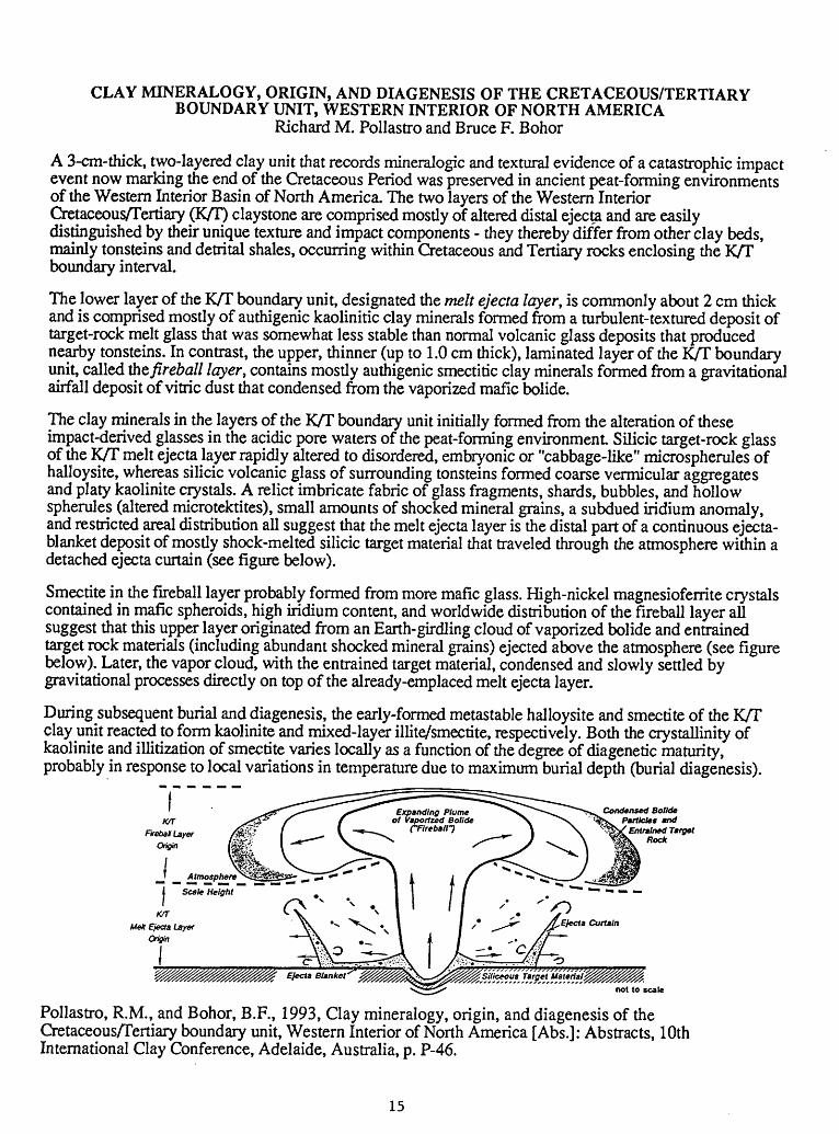
CLAY MINERALOGY, ORIGIN, AND DIAGENESIS OF THE CRETACEOUS/TERTIARY BOUNDARY UNIT, WESTERN INTERIOR OF NORTH AMERICA
Richard M. Pollastro and Bruce F. Bohor
A 3-cm-thick, two-layered clay unit that records mineralogic and textural evidence of a catastrophic impact event now marking the end of the Cretaceous Period was preserved in ancient peat-forming environments of the Western Interior Basin of North America. The two layers of the Western Interior Cretaceous/Tertiary (K/T) claystone are comprised mostly of altered distal ejecta and are easily distinguished by their unique texture and impact components - they thereby differ from other clay beds, mainly tonsteins and detrital shales, occurring within Cretaceous and Tertiary rocks enclosing the K/T boundary interval.
The lower layer of the K/T boundary unit, designated the melt ejecta layer, is commonly about 2 cm thick and is comprised mostly of authigenic kaolinitic clay minerals formed from a turbulent-textured deposit of target-rock melt glass that was somewhat less stable than normal volcanic glass deposits that produced nearby tonsteins. In contrast, the upper, thinner (up to 1.0 cm thick), laminated layer of the K/T boundary unit, called fat fireball layer, contains mostly authigenic smectitic clay minerals formed from a gravitational airfall deposit of vitric dust that condensed from the vaporized mafic bolide.
The clay minerals in the layers of the K/T boundary unit initially formed from the alteration of these impact-derived glasses in the acidic pore waters of the peat-forming environment Silicic target-rock glass of the K/T melt ejecta layer rapidly altered to disordered, embryonic or "cabbage-like" microspherules of halloysite, whereas silicic volcanic glass of surrounding tonsteins formed coarse vermicular aggregates and platy kaolinite crystals. A relict imbricate fabric of glass fragments, shards, bubbles, and hollow spherules (altered microtektites), small amounts of shocked mineral grains, a subdued indium anomaly, and restricted areal distribution all suggest that the melt ejecta layer is the distal part of a continuous ejecta- blanket deposit of mostly shock-melted silicic target material that traveled through the atmosphere within a detached ejecta curtain (see figure below).
Smectite in the fireball layer probably formed from more mafic glass. High-nickel magnesioferrite crystals contained in mafic spheroids, high indium content, and worldwide distribution of the fireball layer all suggest that this upper layer originated from an Earth-girdling cloud of vaporized bolide and entrained target rock materials (including abundant shocked mineral grains) ejected above the atmosphere (see figure below). Later, the vapor cloud, with the entrained target material, condensed and slowly settled by gravitational processes directly on top of the already-emplaced melt ejecta layer.
During subsequent burial and diagenesis, the early-formed metastable halloysite and smectite of the K/T clay unit reacted to form kaolinite and mixed-layer illite/smectite, respectively. Both the crystallinity of kaolinite and illitization of smectite varies locally as a function of the degree of diagenetic maturity, probably in response to local variations in temperature due to maximum burial depth (burial diagenesis).
Condensed Bolide Particles *nd
Entrained Target Rode
Melt Ejecta Layer Origin
Pollastro, R.M., and Bohor, B.F., 1993, Clay mineralogy, origin, and diagenesis of the Cretaceous/Tertiary boundary unit, Western Interior of North America [Abs.]: Abstracts, 10th International Clay Conference, Adelaide, Australia, p. P-46.
15
MINERAL RESOURCES OF THE BLACK MOUNTAIN-MINERS GULCH AREA, ROCKY BOY'S INDIAN RESERVATION, BEARPAW MOUNTAINS, MONTANA.
by Theodore J. Armbrustmacher, Peter J. Modreski, and Harley D. King
The assessment of the precious metals and other mineral commodities of the Black Mountain- Miners Gulch area of the southern part of the Rocky Boy's Indian Reservation by the U.S. Geological Survey (USGS) was begun as a one-year project, concluding in June, 1992. After the discovery of anomalous concentrations of gold in stream-sediment samples, rock samples, and other sampling media collected during the 1991 field season, the Rocky Boy's Tribal Government and the USGS agreed to extend the study through calendar year 1992 in order that the anomalies could be reexamined and evaluated in more detail. In addition to the 210 rock samples, 188 stream-sediment samples, and 182 panned concentrate samples collected during 1991, 132 additional rock samples were collected and analyzed during 1992. Particular attention was given to those areas that contained anomalous gold in samples collected in 1991, but other areas within and adjacent to the Rocky Boy stock were also evaluated.
The Rocky Boy's Reservation in the Bearpaw Mountains contains intrusive and extrusive igneous rocks of Eocene age, which can be divided into two main compositional groups, a silica- saturated porphyritic latite group and an undersaturated, potassium-rich mafic to felsic shonkinite and mafic phonolite group. In the Black Mountain-Miners Gulch area of the Reservation, two alkalic stocks, the Beaver Creek and Rocky Boy stocks, composed of syenite, monzonite, pyroxenite, and nepheline syenite, are associated with known polymetaUic vein, carbonatite, and vermiculite mineralization.
Earlier in the project, six conceptual mineral deposit models were used to evaluate the potential for several types of deposits. These models included (1) polymetallic vein deposits, (2) rare-earth elements (REE), niobium, and other elements in carbonatite, (3) vermiculite deposits, (4) alkaline-hosted gold veins, (5) deposits of zirconium, REE, yttrium, and other incompatible elements in alkaline rocks, and (6) gold placers. Based on the results of the 1991 samples, it was decided to limit the 1992 activities to investigation of the mineral deposit model related to potential alkaline-hosted gold veins.
In the Cabin Creek area, surface rock samples contain up to 6.5 ppm gold (in limonitic gossan associated with quartz-polymetallic sulfide veins) and up to 1.3 ppm in shonkinite and associated igneous rocks, and stream-sediment samples show up to 5 ppm gold. A single sample of a brecciated felsic volcanic rock from the area south of the East Fork of Beaver Creek, near the southeast corner of the reservation, shows an anomalous gold value of 5.1 ppm. At Green, Mahikan (Wolf), and Ranger Creeks near the southern contact of the Rocky Boy stock, stream sediment samples, particularly on Green Creek, have anomalous gold values, up to 0.74 ppm. Other localities near contacts of the stocks with sedimentary rocks show some potential for gold mineralization; one stream sediment sample along Timber Creek contains an anomalous value of 0.12 ppm gold, and at Lost Canyon on the northwest edge of the Rocky Boy stock one rock sample contains 0.41 ppm gold and a number of stream sediment samples have anomalous gold values up to 0.82 ppm.
This is a condensed version of the extended abstract (reference below) presented at the Northwest Mining Association Convention, Spokane, WA, Dec. 2-5,1992, and also at the 1993 National Indian Minerals Conference, Golden, CO, Feb. 2-4, 1993.
Armbrustmacher, T.J., Modreski, P.J., and King, H.D., 1992, Mineral resources of the Black Mountain-Miners Gulch area, Rocky Boy's Indian Reservation, Bearpaw Mountains, Montana [Abs.]: in Manydeeds, S.A., ed., 1992 Mineral Frontiers on Indian Lands, Bureau of Indian Affairs General Publication G-92-2, p. 107-116.
16

RHYOLITE-HOSTED REE-FE-NB-BEARING TITANITE FROM WILLOW SPRING DRAW, SIERRA COUNTY, NEW MEXICO, U.SA.'
Foord, E.E., Hlava, P.P., Erd, R.C., and Lie/tie, F.E.
Miarolitic cavities in rhyolite at a tin prospect along Willow Spring Draw, Sierra County, NM contain a suite of high-temperature minerals deposited from a vapor phase. Relatively unaltered rhyolite contains cavities with hematite, pseudobrookite, calcite, clinopyroxene (salite), titanite, sanidine, tridymitc, and quartz. Other cavities, showing some vapor-phase alteration, contain minor amounts of corroded, salmon pink-orange tilasite crystals to 1 mm, of the following composition: (Ca0^5Na047)(Mg048Fe3+ 0 20Alo.i5Tio.i4MnOOI )(As094P002)O4F. Some medium-red colored crystals contain enough iron to be maxwellite (Fe-analogue of durangitc). Minor amounts of chevkinite or pcrrierite, (Ce,Ca,Th)4(Fe2+ ,Mg)2(Ti,Fe3+ )3Si4O22, occurring as gray-brown crystals as much as 0.2 mm in maximum dimension, also have been found within fresh rhyolite. This particular chcvkinilc-pcrricrite is somewhat unusual because of its high ZrO2 content (3.04 wt. %).
Salite associated with the titanite forms transparent orange or orange yellow cuhcdral needles as much as several mm long but only 0.01 mm wide. The calculated composition is(Ca079Na018)(Mg071 Fe3+ 0 i 8Fe2+ 013Mn007)(Sii 93Alow)(O595F005). Fe has been assigned as ferrous and ferric so as to balance the amount of sodium present.
The titanite is unusual because of its high content (approx. 15 wt. % oxides) of elements other than Ca,Ti,Si and O. Crystals arc euhcdral, sharp, lustrous, transparent red to red brown and may be as much as 1 mm in maximum dimension. A combination of electron microprobc and laser-ablation 1CP-MS analyses gave (in wt. %): SiO2 28.5, A1 2O3 1.90, P2O5 0.10, Na2O 0.10, MgO 0.72, CaO 23.0, TiO2 24.2, total Mn as Mn 2O3 1.10, total Fc as Fe2O3 7.50, Y2O3 2.70, other RE2O3 5.50, Nb2O5 1.60, ZrO2 0.20, Sb2O5 0.20, SnO 2 0.60, F 2.0, V2O5 0.10, ThO2 0.20, Ta2O5 0.05, O for F 0.85, total 99.42. Both Fe and Mn are likely all or nearly all trivalcnt because of extreme oxidizing conditions during deposition as evidenced by coexisting hematite and pseudobrookite. Water was not determined but is likely absent because of the high-temperature, low pressure mode of origin. An empirical formula calculated on the basis of 5 (O + F) is: (Ca0 _86REE0., 2Na0-01 )j; 0 _99(Ti0jMFc3+ 0j0Alo.o7Mg0.04Mn3+ 0.03Nb0 .02 S|1o.oi)ri.oo(S^.9sAVoi)ri.oo^4(Oo.78fro.22)- A CNR (chondritc-normalizcd ratio) plot of the REE distribution in the Willow Spring titanite shows a LREE enrichment trend. A depletion spike, present for Cc, is likely due to oxidation of some of the Ce to the tetravalent state and resultant non-incorporation in the structure. A Eu depletion spike is present and is normal, due to incorporation of Eu in simultaneously crystallizing feldspar.
Detailed (148 points across an 0.025 mm grain) traverse data show the titanite to be chemically zoned with REE-cnriched cores and Ca-Ti enriched rims. Fe was relatively constant across the grain. The predominant substitutions that occurred are 2REE3+ Ca2+ + Ti4+ and (Al + Fc3+ ) + (F 1 ) Ti4+ + O 2\
Published chemical data for titanite from rhyolite are scarce or lacking and data from high-F and Sn-bearing rhyolite are even more so. The chemistry of this titanite is much like that from chemically evolved and fractionated granitic pegmatites. Rare and incompatible elements were incorporated into the titanite during final stages of consolidation of the rhyolite.
'Part of this work conducted at Sandia National Laboratories, supported by U.S. Dcpt. of Energy under contract number DE-AC04-76DP00789.
Foord, E.E., Hlava, P.P., Erd, R.C., and Lichte, F.E., 1993, Rhyolite-hosted REE-Fe-Nb-bcaring titanite from Willow Spring Draw, Sierra County, New Mexico, U.S.A., in Rare Earth Minerals: Chemistry, Origin and Ore Deposits, April 1-2, 1993, Mineralogical Society of Great Britain and Ireland and the Natural History Museum, London, p. 39-41.
17

MAJOR-ELEMENT EVIDENCE FOR MULTIPLE MAGMA BATCHES IN THEEVOLUTION OF PLEISTOCENE AND HOLOCENE VOLCANIC ROCKS OF
THE MARKAGUNT PLATEAU VOLCANIC FIELD, SOUTHWESTERN UTAH
L. David Nealey, Florian Maldonado, Daniel M. Unruh, and Jim Budahn
Pearce element ratios (PER) provide an initial understanding of the evolution of Pleistocene and Holocene alkali basalt to trachyandesite magmas of the Markagunt Plateau. The magmas erupted from numerous cinder cones, shield-like centers, and dikes. Vent areas were controlled by structures (e.g., grabens) related to the tectonic evolution of the transition zone between the Basin and Range and Colorado Plateaus provinces. The cinder cone-fed basalt flows and a single dike-fed basalt flow are probably older than shield-fed basalt and trachyandesite flows. Chemically, cinder cone- and dike-fed basalt flows are more mafic (45.6-50 weight percent SiO2 ; normative ne<8 to hy<8) than shield-fed basalt flows (49.4-52.8 weight percent SiO2; normative hy>5). Trachyandesite flows are latite and benmoreite (58.7-59.7 weight percent SiO2).
PER analysis of flow chemistry indicates that the shield-fed flows represent at least three cogenetic magma batches, that cinder cone-fed flows must be related to more than one magma batch, but that all andesite is genetically related to a common parent magma. The dike-fed basalt flow is not genetically related to any other magma type. Although several magma batches erupted, chemical variations in the magmatic series are consistent with the fractionation of the observed phenocryst phases: olivine, plagioclase, clinopyroxene, and spinel (correlation coefficient (R2)=0.9996). This four-phase fractionation assemblage relates compositional differences within each basalt type better than it does the entire magmatic series. Fractionation of no single mineral phase can adequately explain chemical variations in the basaltic magmas of the Markagunt Plateau.
Published originally as:Nealey, L. D., and Maldonado, Florian, 1993, Major element evidence for multiple magma batches in
Markagunt Plateau volcanic field, southwestern Utah: Geological Society of America Abstractswith Programs, v. 25, no. 5 , p. 126.
18

Delineation of Terranes Favorable for the Occurrence of Lode Gold Deposits in the Coast Ranges and Western Klamath Mountains, Western Half of the Redding 1x2 Degree Quadrangle, Northern California
Silberman, M.L., J.R. Hassemer, J. Force and R.B. Tripp(U.S. Geological Survey, Denver Federal Center,
Mail Stop 973, Denver, CO 80225)
The U.S. Geological Survey has just completed a reconnaissance geologi cal, geochemical and geophysical study of the Redding 1* X 2* Quadrangle as part of the CUSMAP program. The western half of the Redding 1* x 2* Quadrangle, contains parts of the Kla math Mountains and the Coast Ranges. Both provinces art underlain by ac creted oceanic and island arc terranes whose ages decrease from east to west. Accretion or amalgamation of the ter ranes occurred from the Devonian through the Early Tertiary. The terra- nes contain varying proportions of tur- bidiic sandstone, mudstone, shale, green stone, chert, minor limestone or their metamorphosed equivalents. The ter- rane boundaries are eastward-dipping thrust faults, many of which contain serpentinized ultramafic intrusions. The ultramafic rocks are parts of ophiolites that were deformed, dismembered, remobilized and intruded during amal gamation or accretion.
. The most significant difference be tween the Klamath Mountains and the Coast Ranges is the occurrence of granitic to intermediate and mafic batholiths, plutons and their hypabyssal offshoots of Devonian to Cretaceous age in the former, and their absence in the latter. However, a recently completed geo physical survey suggests that subsur face plutonic rocks occur in the Coast Ranges.
Within the western half of the Red ding Quadrangle, the most common
mineral deposits in the Coast Ranges and Klamath Mountains are Mn-chert deposits associated with mafic volcanic rocks. Small massive sulfide deposits containing Cu, Zn and some Au and Ag occur in volcanic rocks, and sedimen tary rocks associated with the volcanic rocks, more commonly in the Klamath Mountains province than the Coast Ranges. Many larger examples of these deposits occur in the eastern half of the Redding Quadrangle. Small, mesoth- ermal Au-quartz veins occur in a wide variety of lithoiogies in the western Klamath Mountains. Many similar but larger Au-quartz vein deposits are common in the Klamath Mountains in the eastern half of the quadrangle where they are spatially associated with granitic plutons or dikes, sills and irregular small intrusions that are their hypabyssal offshoots. Placer Au and Au-PGE deposits occur mostly along the Trinity River and its tributaries in the Klamath Mountains. A few small isolated plac ers occur along rivers and streams in the Coast Ranges, and beach placers con taining Au and Au-PGE occur along parts of the Pacific Coast Areas of placer occurrence are much more wide spread than lode Au deposits.
Small deposits consisting of dissemi nated auriferous copper sulfides, and copper sulfide veins hosted in serpentinite and diorite and plagiogranite dikes which intrude die scrpentiniics occur in both provinces but are more common in the Klamath Mountains. Deposits of this type are known in ophiolitic recks in
other pans of the world, but arc not well documented in the U.S. The largest of these, at Horse Mountain, produced between 100.000 and 1,000,000 Ib of Cu and an unknown quantity of Au. A few small podiform chromite deposits occur in ultramafic complexes in both provinces.
Geochemical data from Au-vein and VMS Cu-Zn mines and prospects, and stream sediments from drainages con taining the deposits have been used to establish elemental associations that are favorable for the occurrence of these deposits. Elements enriched in the two types of deposits and in streams near them overlap. Anomalous Au, with As, Hg, Ag, Cu, Pb and Zn, alone or in combination, are favorable indicators for the presence of either type of de posit. Copper with Zn and Pb anoma lies are more indicative of VMS depos its, and Au with As, Hg and/or scheeJite- W anomalies are more indicative of Au-vein deposits but the distinctions are not rigorous.
There are 52 drainages or drainage clusters (2 or more adjacent drainages) that are anomalous in Au in die western' half of the Redding Quadrangle. Of these, on ly 6 are associated with known Au deposits. Of these 6 drainage clus ters; all contain anomalies of Au in combination with two or more of the commonly associated elements listed previously. Those drainages or drain ages clusters that contain Au-multiele- ment anomalies are most prospective for occurrence of Au deposits, but any Au anomaly warrants further investiga tion.
All of the rock types present in the Coast Ranges and western Klamath Mountains are favorable host rocks for lode-Au deposits. Areas that are in truded by granitic plutons are particu larly favorable since many of the Au deposits in die Klamath Mountains are spatially associated with plutonic rocks or their hypabyssal offshoots such as dikes, sills and irregular small intru sions.
AC-1 Integrated Methods in Exploration and Discovery
Thirty-one of the Au-anomalous clusters occur in die western Klamath Mountains. Of these, 25 are multiele ment anomalies. Those that occur in the eastern Hayfork tenane are large and particularly prospective because of die occurrence of granitic plutons or the geophysical evidence of their subsur face presence in die anomaly areas. Eight of the Au-anomaJy clusters occur along the South Fork Mountain fault, the boundary between the CoastRanges and Klamath Mountains provinces, of
which 7 are multielement The geo logic setting along this structure is not dissimilar to that at the McLaughlin gold mine, in Napa County, along the Coast Ranges thrust fault to the south.
Twenty-one of the Au-anomalous clusters occur in the Coast Ranges, of which 17 are multielement Many of the Au anomalies in both provinces are surrounded by drainages (hat are anoma lous in As and/or Hg, which are con sider also an indication of the possible
presence of Au-vein deposits, or per haps other types of Au-bearing systems such as VMS deposits.
Although the western half of the Redding Quadrangle has produced, at most, only 10% of the approximately 3 M oz of lode Au from the entire quad rangle, the geologic geophysical and geochemical data derived from our regional studies suggest that significant potential exists for the occurrence of undiscovered Au-bearing deposits.
Silberman, M.L., Hassemer, J.R., Farce, J., and Tripp, R.B.,1993, Delineation o-f terranes -favorable -for the occurrence o-f lode gold deposits in the Coast. Ranges and western Klamath Mountains, western half a* tiMt Redding^ 1x2 degree quadrangle, northern California, in Romberger, S.B., and Fletcher, D.I., editors, Integrated Methods in Exploration and Discovery: Society o-f Economic Geologists Conference Program and Extended Abstracts, p. AB 104-107.

LIMESTONE-PEBBLE CONGLOMERATE FACES OF THE EOCENE GHAZLTFORMATION, BALOCHISTAN, PAKISTAN: EVIDENCE FOR COLLISION-RELATED
TECTONISM ON THE NORTHWESTERN MARGIN OF THE INDIAN PLATEBy Edward A. Johnson, Peter D. Warwick, Stephen B. Roberts, and Intizar H. Khan
The abrupt appearance of conglomerates in the otherwise finer grained paralic to marine Ghazij Formation (Eocene) in northeastern Balochistan, Pakistan, indicates tectonism associated with crustal collision. These poorly sorted limestone-pebble conglomerates consist of gray well- rounded pebbles and cobbles of limestone and subordinate chert in a matrix of lithic sandstone, and the facies is present in two widely spaced depocenters. In the Harboi Hills, outcrops locally show stratification and normal grading, and the conglomerate is commonly clast supported; some boulders are present. Channel-form bodies 2 m thick, some having accretionary surfaces, comprise amalgamated sequences that also contain cross-stratified sandstone lenses. This 439- m-thick wedge-shaped unit is present in the upper part of the Ghazij and grades eastward into paralic deposits within several kilometers. In the Sor Range, 137 km north of the Harboi Hills, outcrops locally show faint stratification, normal grading, and imbrication. The conglomerate is commonly matrix supported and contains cross-stratified sandstone lenses. Channel-form bodies 1 m thick and scoured surfaces are locally present. The unit is at the top of the middle part of the Ghazij, is 6-39 m thick, has a sharp top and erosional base, and is traceable for 12 km. To the southeast, the unit apparently pinches out into paralic deposits.
High relief associated with sudden uplift west of the study area caused rapid erosion that provided molasse to a mountain-front foreland basin. An irregular belt of alluvial fans formed along the eastern margin of the uplift, and the two sites in this study represent separate depositional lobes of this system. The sequence in the Harboi Hills was deposited in a more proximal position than the tabular body observed in the Sor Range. These conglomerates provide evidence of tectonism caused by the collision of the northward-drifting Indian plate with undefined landmasses that existed marginal to the Eurasian supercontinent
Johnson, E.A., Warwick, P.D., Roberts, S.B., and Khan, I.H., 1993, Limestone-pebbleconglomerate facies of the Eocene Ghazij Formation, Balochistan, Pakistan: evidence for collision-related tectonism on the northwestern margin of the Indian Plate [Abs.]: American Association of Petroleum Geologists 1993 Annual Convention Program, p.-124-125.
20

Sequence boundaries and other surfaces in Lower and lower Upper Cretaceous rocks of central and southwest Montana
PORTER, KAREN W., Montana Bureau of Mines and Geology, Butte, MT, THADDEUS S. DYMAN AND RUSSELL G. TYSDAL, U.S. Geological Survey, Denver, CO
In the Montana portion of the Western Interior sedimentary basin, Lower and lower Upper Cretaceous strata contain several types of conformable and unconformable stratigraphic surfaces that can be related in a sequence stratigraphic framework. Some surfaces are interpreted as sequence boundaries; others are contained within sequences, such as transgressive surfaces of erosion, local scour surfaces, and condensed sections associated with maximum flooding. Together, these surfaces record the sedimentary response of terrestrial (southwest Montana) and marine (central Montana) environments within the basin to relative sea-level changes.
Four sequence boundaries (SB1-SB4) in upper Aptian, Albian, and Cenomanian rocks are recognized and correlated regionally. The oldest, SB1, of late Aptian or early Albian age, is placed within the upper Kootenai Formation, at the base of the gastropod limestone interval, in southwest Montana; it records a rise in regional base level in terrestrial deposits. In central Montana, SB1 is placed at the top of the Kootenai Formation, where coastal deposits of the Fall River Sandstone onlap Kootenai redbeds. SB2, of late Albian or early Cenomanian age, is placed within the upper sandstone unit of the Flood Member of the Blackleaf Formation, and within the correlative Muddy Sandstone, in southwest Montana. It is correlated with a chert-pebble bed in marine shales of the lower Thermopolis Shale in central Montana. SB3 is recognized in the lower Cenomanian Mowry Shale in the Madison Range; its regional relations are presently uncertain. SB4, of early middle Cenomanian age, is recognized at the top of oxidized terrestrial rocks of the Vaughn Member, or in lower Frontier beds, in southwest Montana. It is correlated with a gravel bed recognized in marine shales of the lower Belle Fourche Shale in central Montana.
Porter, K.W., Dyman, T.S., and Tysdal, R.G., Sequence boundaries and other surfaces in Lower and lower Upper Cretaceous rocks of central and southwest Montana [abs.]: American Association of Petroleum Geologists Bulletin, v. 77, no. 8, p. 1458.
21

A REGIONAL MARKER UNIT WITHIN THE UPPER PALEOZOIC BIRDSPRING FORMATION, SOUTHERN NEVADA:
EVIDENCE FOR A SLOPE FACIES
By William R. Page
A distinctive unit within the latest Mississippian to Permian Bird Spring Formation of southern Nevada is interpreted as a slope facies between the Lower Permian eastern shelf margin and interior sea. Members of the Bird Spring are difficult to define and correlate across southern Nevada because of the formation's great thickness, lithologic heterogeneity, and structural complexity. The newly described unit, 35 to greater than 200 m thick and 1,000 m above the base of the Bird Spring, is a prominent marker unit that will facilitate regional stratigraphic and structural studies in southern Nevada. Outcrops of the marker unit can be traced for 100 km from the north, in the southern Delamar Mountains, Lincoln County, to the south in the northern Spring Mountains, Clark County, where it is offset approximately 45 km along the right-lateral Las Vegas Valley shear zone. The unit is exposed between these locations in the Meadow Valley Mountains, Arrow Canyon, and Las Vegas Ranges, Clark County.
The marker unit consists of laminated micritic limestone and chert interbedded with calcareous siltstone. The limestone is spiculitic and organic rich, and radiolarians were identified in some samples. Distinctive concretions at the base of the unit commonly contain fish-bone fragments at their core. Sedimentary structures include convolute bedding and minor slumps, and at the top of the marker unit in the southern Arrow Canyon Range, submarine debris flows consist of cobble-size clasts of shelf- facies rocks in a silty, micritic limestone matrix. Shelf bioclastic limestones bound the marker unit below and above at all outcrop locations. The spiculitic limestone, radiolarians, soft-sediment deformation, and debris flows suggest rapid deposition in deep water, characteristic of a slope depositional environment. The marker unit is Wolfcampian in age.
Page, W.R., 1992, A Regional marker unit within the upper paleozoic Bird Spring Formation, southern Nevada: evidence for a slope facies [abs.]: Geological Society of America Abstracts with Programs, v. 25, no. 5, p. 131.
22
PALEOGEOGRAPHIC INFERENCES FROM A PALEOCURRENT STUDY OFPENNSYLVANIAN TO EARLY PERMIAN ROCKS OF THE OQUIRRH AND
WOOD RIVER BASINS IN NORTHWESTERN LESSER PANGEA.By David Seeland
The Oquirrh and Wood River Basins (OWB) were originally a single basin extending from central Utah to central Idaho. Only limited paleocurrent work has been done by others in the carbonate-siliciclastic rocks of the basin, which are as much as 7,500 m thick. This previous work shows multiple transport directions, suggesting multiple sources, sub-basins, and current regimes. Other investigators have proposed sediment sources for the OWB that lie both to the west, the Antler Orogenic Belt, and to the east, the craton and associated uplifts such as the Uncompahgre. In order to provide a regional sediment transport framework, about 550 crossbed, slump- fold, current-lineation, and ripple-mark orientations were determined at 65 field localities in the OWB and on adjacent shelves.
In the OWB, the dominant marine transport direction was to the south, parallel to the basin axis, with a secondary mode to the west. On the basin's eastern shelf, the winds were from the north (present directions), and the marine currents flowed toward the south. Sparse data suggests a southerly marine transport direction in eastern Nevada. A previous investigator determined a southeasterly paleoslope in the northern OWB based on slump-fold vergence and a similar marine current transport direction based on crossbedding. The data set of this study did not confirm these results.
Southerly, basin-axis-parallel, marine currents were dominant both in the OWB and on its shelves. A secondary paleocurrent mode indicates that the margin of the eastern shelf was a possible subsidiary carbonate-siliciclastic source. The major siliciclastic source probably is the slightly arkosic sandstone and quartzite of the Belt Series, possibly at the intersection of the Antler orogen and the western Belt Basin in northern Idaho. Pebbles of red jasper in Wolfcampian conglomerates in the northern OWB support this hypothesis. It is suggested that sand was carried southward through both the OWB and the Bird Spring Trough into the Keeler Canyon Basin in southeastern California.
Seeland, David, 1993, Paleogeographic Inferences from a Paleocurrent Study ofPennsylvanian to Early Permian Rocks of the Oquirrh and Wood River Basins in Northwestern Lesser Pangea [Abs.]: Geological Society of America Abstracts with Programs, vol. 25, no. 5, p. 144..
23

FLUID FLOW ALONG A FAULT--PETROFABRIC EVIDENCE FROM A FAULT BEND,ENGLISH HILL FAULT SYSTEM, SOUTHEAST MISSOURI
By Sharon F. Diehl and C.W. Clendenin
Northeast- and northwest-striking, carbonate-filled veins are associated with a dilational jog along a northeast-striking segment of the English Hill fault system, exposed at Grays Point, Missouri. Some veins consist of en echelon segments. Petrofabric analysis shows successive filling of the veins and substantiates mapping that indicates repeated reactivation on the fault. Vein filling can consist of five generations of calcite, which can be distinguished in terms of textural variations as well as Mg and Fe content. Deformation and fluid flow along the vein network repeatedly plucked limestone clasts from the margins of the veins. The presence of sigmoidally deformed clasts in northeast-striking veins confirms that a component of right-lateral movement exists on the fault. Undeformed clasts encased in vein calcite are evidence of successive failure by dilation. That some veins show brecciation followed by dilation suggests implosion brecciation.
Significant strain incompatibilities at fault bends produce fluid flux (Pavlis and others, 1993); and at Grays Point, this relation is indicated by the progressive filling of veins. Multiple episodes of dilation suggest cyclic build-up and release of fluid pressures. This cyclic nature of fluid pressures is a consequence of the fault system adjusting to minimize the strain incompatibilities at the dilational jog during repeated periods of earthquake activity.
Diehl, S.F., and Clendenin, C.W., 1993, Fluid flow along a fault Petrofabric evidence from a fault bend, English Hill fault system, southeast Missouri: Geological Society of America, Abstracts with Program, v. 25 , p. A166.
24

ANASTOMOSING GRABENS, LOW-ANGLE FAULTS. AND TERTIARY THRUST(?)FAULTS, WESTERN MARKAGUNT PLATEAU,
SOUTHWESTERN UTAHBy Florian Maldonado and Edward G., Sable,
A structurally complex terrane composed of erabens and horsts, low-angle faults, Tertiary thrust(?) faults, gravity-slide blocks, and debris deposits has been mapped along the western Markagunt Plateau, east of Parowan and Summit, southwestern Utah. This terrane, structurally situated within the transition between the Basin and Range and Colorado Plateau provinces, contains Tertiary volcanic and sedimentary and Cretaceous sedimentary rocks. The structures are mostly Miocene to Oligocene but some are Pleistocene.
The oldest structure is the Red Hills low-angle shear zone, interpreted as a shallow structure that decoupled an upper plate composed of a Miocene-Oligocene volcanic ash-flow tuff and volcaniclastic succession from a lower plate of Tertiary sedimentary rocks. The period of deformation on the shear zone is bracketed from field relationships between 22.5 and 20 Ma. Other low-angle faults mapped represent a younger period of deformation possibly related to uplift of the Markagunt Plateau.
The graben-horst system trends northeast and formed after about 20 Ma (and probably much later) based on displacement of dated dikes and a laccolith. The central part or the system contains many srabens that merge toward its southerly end to become a single graben. Within these grabens, (1) older structures are preserved. (2) debris eroded from horst walls forms lobe-shaped deposits, (3) Pleistocene basaltic cinder cones have localized along graben-bounding faults, and (4) local folding of rock units suggests some component of lateral translation along these faults.
Apparent thrust faults along the front of the western Markagunt Plateau juxtapose an upper plate of Late Cretaceous Iron Springs Formation and Paleocene to Oligocene sedimentary and volcanic rocks with a lower plate of Tertiary Claron Formation and older rocks. The youngest exposed rock unit in the upper plate is the approximately 27-Ma Isom Formation. These puzzling faults may be true tnrust faults, related to strike-slip faulting along the plateau margin; may be tilted sub vertical normal faults; or may actually be megasfide blocks overlying a monoclinal fold related to uplift of plateau or adjacent Red Hills.
Megabreccia deposits and landslide debris are common. Megabreccia deposits are interpreted as gravity-slide blocks of Miocene-Oligocene(?) age resulting from formation of the Red Hills shear zone, although some may be related to volcanism, and still others to later deformation. The debris deposits are landslides of Pleistocene-Pliocene(?) age possibly caused by continued uplift of the Markagunt Plateau.
Maldonado, Florian and Sable, Edward G.. 1993, Anastomosing grabens,low-angle faults, and Tertiary thrust (?) faults, western Markagunt Plateau, southwestern Utah [Abs.]: Geological Society of America, Abstracts with Programs, v. 25. no. 5, p. 113.
25

Backflooding Upstream from the Resurgent Dome of the 0.6 Ma Yellowstone Caldera Two Backflooding Cycles in the last 8,000 years.
K.L. Pierce (USGS, MS 913, Box 25046, Federal Or., Denver, CO 80225)K.P. Cannon, and G. M. Crothers (Midwest Arch. Or., N P S, 100 Centennial Mall N, Lincoln, NE 68508)Grant Meyer (Dept. Geol., Middlebury College, Middlebury, VT 05753)Meyer Rubin (USGS, 791 National Center, Reston, VA 22092)
Historic surveys between 1923 and 1984 show nearly 1 m of doming of the center of the 0.6 Ma Yellowstone cal- dera, with subsidence after 1985 (Pelton and Smith, Science, 1979, Dzurisin and Yamashita, JGR, 1987). Hy potheses to explain such doming include magma intrusion, geothermal sealing with pressure buildup, and tectonic- ma gmatic interaction. Our studies of Yellowstone Lake shorelines near Fishing Bridge and of Yellowstone River channels and terraces from Fishing Bridge to the dome axis at Le Hardy Rapids place this doming in a Holocene context.
The current backjlooding cycle has converted the Yellowstone River to a wide pool from its outlet to the bedrock threshold at Le Hardy Rapids. Gravels 3 km upstream from Le Hardy Rapids are now submerged beneath 4 m of mud and sand that started accumulating about 2,700 yr B.P. We estimate about 5 m of tilting on this 3 km reach, based on 2 m of submergence of river gravels (estimated depositional water depth 2 m) and 3 m of back tilt of gravels (estimated depositional gradient Im/km). Submerged shorelines near the lake outlet (1990 study by Ham ilton and Bailey) and drowned valleys along the northwest side were both graded 2,800 yr B.P. to a lake about 5 m lower.
The second-older cycle of backflooding is recorded by an S-shaped meander 3 to 0 m above the present Yellow- stone River. A spit constructed across this meander (Meyer and Locke, Geology, 1986) and shoreline benches 4 and 2 m above the top of river gravels indicate that this meander was backflooded and became an arm of Yellow- stone Lake. Backflooding of the previously vigorously flowing river was underway 8,200 yr B.P. Using the same assumptions as for the current cycle, 5 m tilting occurred over 3 km. This backflooding cycle roughly ties to the Museum shoreline at Fishing Bridge, which is currently being dated by archeological studies.
Third- and fourth-older cycles are suggested by 6 and 8 m river terraces that formed after deglaciation about 15,000 yr B.P. The river terrace of the third cycle ties approximately to the Hamilton-Store shoreline. This shore line is older than 7,500 yr B.P.; a closer limiting age is provided by Cody Complex projectile points produced about 9,000 yr B.P.
Deformation different from the historic doming also occurs in the Fishing Bridge area. Meyer and Locke (Geology, 1986) show that the Hamilton-Store shoreline (early Holocene?) is downwarped 3 m near Fishing Bridge but that the Museum shoreline (mid Holocene?) is horizontal. An offshore graben strikes northward towards Fishing Bridge where it might have lowered the outlet area, but it has not been recognized onshore. For the cur rent backflooding cycle, the 3 km distance between the dated, backflooded river gravels and the threshold at Le Hardy Rapids spans only the crestal 1/4 of the total historic uplift. Because the Museum shoreline is undeformed and older than this cycle, localized younger deformation centering near Fishing Bridge seems unlikely. If the total dome of historic uplift is used as a template, then total doming since 2,700 yr B.P. would be 4 times greater, or about 20 m For the second backflooding cycle, interpretation may be complicated by downwarping of the slightly older Hamilton Store shoreline (we determine 1.8 m) and unrecognized onshore faulting; nevertheless, the backflooding of a previously vigorously flowing Yellowstone River was the same as that which occurred 5,000 years later, and therefore seems also attributable to similar-amplitude doming.
Pierce, K.L., Cannon, K.P., Crothers, G.M., Meyer, Grant, and Rubin, Meyer, 1993, Backflooding upstream from the resurgent done of the 0.6 Ma Yellowstone caldera- two backflooding cycles in the last 8,000 years: Eos,v. 74. No. 43, P. 592.
26
STRATIGRAPfflC COMPARISON OF THE EVAPORTTE-BEARING EARLY MESOZOIC
FUNDY AND ARGANA BASINS, NOVA SCOTIA AND MOROCCO
Joseph P. SmootThe early Mesozoic Fundy basin in Nova Scotia, Canada, and the Argana basin in Morocco
formed during the initial Pangean rifting event that subsequently led to the opening of the Atlantic
Ocean. Both basins are fault-bounded in a strike-slip terrane with thick border conglomerates
deposited on alluvial fans. The deposits (and ages) of the Fundy basin are from base to top: 1)
Rash-flooding ephemeral-stream deposits alternating with eolian dune deposits or deflation
surfaces (Anisian), 2) Deposits of large anastomosing to meandering streams that had heavily
vegetated flood plains (Middle to Late Camian - apparently overlying an unconformity), 3) A
return to ephemeral-stream and eolian-dune deposits (Late Camian to Early Norian), 4) Cyclic
alternations of shallow to deep lake deposits with saline mudflat deposits containing efflorescent
salt-crust fabrics (Norian), 5) Tholeiitic basalt flows (Early Hettangian), and 6) Cyclic alternations
of lake deposits bearing abundant fish and invertebrate fossils with root-disrupted mudstone or
birdfoot-delta sandstone (Early Hettangian). Preliminary investigation of the Argana basin
indicates a strikingly similar sedimentary succession. The ages of the Argana deposits range from
Late Triassic to Early Jurassic, but the basal deposits beneath the unconformity have been
interpreted to be as old as Permian. The stratigraphic successions in these basins are interpreted
to indicate changes in climate from arid to wet conditions concommitant with basin evolution from
open drainage to closed drainage. The timing of climatic changes in the Fundy basin is consistent
with that of all of the Newark Supergroup basins along the eastern edge of North America, but
the Fundy basin is unique in the Newark Supergroup in the abundance of eolian sandstone and
the predominance of lake cycles dominated by efflorescent salt-crust fabrics, both of which have
been cited as evidence for greater aridity in northern paleolatitiudes. The similarity of the climatic
successions in the Fundy and Morocco basins is interpreted as indicating correlative ages of the
units, and can be used to constrain the age of other evaporites around the proto-Atiantic. The
Argana basin occupied a more southerly paleolatitude than the Fundy but was still north of the rest
of the Newark Supergroup, which is consistent with the paleolatitude model. However, both
basins are onshore extensions of buried basins on the continental shelf and the eolian and
evaporite environments may be more reflective of local controls such as orographic effects.
Smoot Joseph, P., 1993, Stratigraphic comparison of the evaporite-bearing early Mesozoic
Fundy and Argana basins, Nova Scotia and Morocco: Carboniferous to Jurassic Pangea,
Annual Convention of the Canadian Society of Petroleum Geology with the Global
Sedimentary Geology Program, Calgary, Alberta, Canada, Program and Abstracts, p.
287.