
U.S. COAST GUARD GPS INFORMATION CENTER (GPSIC…tycho.usno.navy.mil/ptti/1992papers/Vol...
16
U.S. COAST GUARD GPS INFORMATION CENTER (GPSIC) AND ITS FUNCTION WITHIN THE CIVIL GPS SERVICE (CGS) GPSIC staff Updated November 3, 1992 Abstract In 1987, the U.S. Department of Defense (DOD) formally requested that the U.S. Department of hnsportation (DOT) tnke responsibility for providing an ofice that would respond to nonmilitary user needs for GPS information, data, and assistance. DOT accepted this responsibilitg and in February 1989, named the Coast Guard as their lead agency for the project. Since that time, the U.S. Coast Guard has worked with the U.S. Space Command to develop requirements and implement a plan for providing the requested interface with the civil GPS community. The Civil GPS Service (CGS) consists of four nuin elements: GPS Informotion Center (GPSIC) -provides GPS status information to c ivh users of the system Civil GPS Service Interface Commiitee (CGSIC) - established to iden%ify civil GPS user technical information needs in support of the CGS program Differential GPS (DGPS) - Coasl Guard Research and Development Project PPS Program Ofice (PPSPO) - (Under development) will administer the program allowing qualjied civil users to have access to the PPS signal This paper will provide details aboW the services these organizptions provide. OVERVIEW OF THE CIVIL GPS SERVICE I In 1987, the Department of Defense (DOD) formally requested the Department of Transportation (DOT) assume responsibility for establishing and providing an office that would respond to nonmilitary user needs for GPS information, data, and assistance. In February 1989, the Coast Guard assumed the responsibility as the lead agency within DOT for this project. Three areas requiring interaction were I identified: Near real-time operational status reporting Distribution of the precise satellite ephemerides
Transcript of U.S. COAST GUARD GPS INFORMATION CENTER (GPSIC…tycho.usno.navy.mil/ptti/1992papers/Vol...

U.S. COAST GUARD GPS INFORMATION CENTER (GPSIC)
AND ITS FUNCTION WITHIN THE CIVIL GPS SERVICE (CGS)
GPSIC staff Updated November 3, 1992
Abstract
In 1987, the U.S. Department of Defense (DOD) formally requested that the U.S. Department of hnsportation (DOT) tnke responsibility for providing an ofice that would respond to nonmilitary user needs for GPS information, data, and assistance. DOT accepted this responsibilitg and in February 1989, named the Coast Guard a s their lead agency for the project. Since that time, the U.S. Coast Guard has worked with the U.S. Space Command to develop requirements and implement a plan for providing the requested interface with the civil GPS community.
The Civil GPS Service (CGS) consists of four nuin elements:
GPS Informotion Center (GPSIC) -provides GPS status information to c i v h users of the system
Civil GPS Service Interface Commiitee (CGSIC) - established to iden%ify civil GPS user technical information needs in support of the CGS program
Differential GPS (DGPS) - Coasl Guard Research and Development Project
PPS Program Ofice (PPSPO) - (Under development) will administer the program allowing qualjied civil users to have access to the PPS signal
This paper will provide details aboW the services these organizptions provide.
OVERVIEW OF THE CIVIL GPS SERVICE
I In 1987, the Department of Defense (DOD) formally requested the Department of Transportation (DOT) assume responsibility for establishing and providing an office that would respond to nonmilitary user needs for GPS information, data, and assistance. In February 1989, the Coast Guard assumed the responsibility as the lead agency within DOT for this project. Three areas requiring interaction were
I identified:
Near real-time operational status reporting Distribution of the precise satellite ephemerides

Civil use of the precise positioning service
In 1988, the U.S. Space Command (USSPACECOM) invited the U.S. Coast Guard to assist in the development of the DOD Operational Capability Reporting Management System (ORMS). Since that time, the U.S. Coast Guard Radionavigation Division has worked with USSPACECOM to develop requirements and implement a plan to provide the requested interface with the nonmilitary GPS community. Most of these civil GPS services are now in place; others are planned to be ready by the time GPS is fully operational.
ORGANIZATIONAL STRUCTURE OF THE CIVIL GPS SERVICE As the Department of Transportation (DOT) operational agency, the U.S. Coast Guard is responsible for the oversight and management of the Civil GPS Service. The function is implemented by the organizational shown in Figure 1.
Chief, Offlce of Navigation Safety and Waterway Services (G-N) - located at Coast Guard Headquarters, provides top-level oversight and management of the CGS program. The primary responsibility is the provision of broad, high-level policy guidance. This direction is provided in support of:
DOT positions Congressional mandates Federal Radionavigation policies
This office is the focal point for information feedback from the Civil GPS Service Interface Committee. Members of this staff interface with the heads of other Federal agencies with an interest in the Civil GPS Service program.
Chief, Radionavigation Division (G-NRN) - also located at Coast Guard Headquarters, is the program manager responsible for the activities of the PPSPO and the GPSIC operations. This office assists with the budgetary planning for these services.
The Civil GPS Service consists of four main elements:
The GPS Information Center (GPSIC) is the operational entity of the CGS which provides GPS status information to civilian users of the Global Positioning System based on input from the:
GPS control segment Department of Defense (DOD) Other sources
The Civil GPS Service Interface Committee (CGSIC) was established to identify civil GPS user technical information needs in support of the Civil GPS Service program. Its purpose and goal is of an information exchange nature only.
The Coast Guard's Differential GPS (DGPS) Project was established to develop an extension of GPS to enhance the Standard Positioning Service (SPS) for civil users in the maritime regions of the United States. 1 The PPS Program Office (PPSPO) is responsible for administering the program which will allow qualified civil users to have access to the Precise Positioning Service (PPS) signal. This program ofice

is currently under development in the Radionavigation Division of the Office of Navigation Safety and Waterways Service (G-NRN-2) located at Coast Guard Headquarters in Washington, D.C.
The DOT Navigation Council and the DOT Radionavigation Working Group will continue in their traditional roles in the oversight of navigation including radionavigation.
n o other DOT agencies have Civil GPS Service functions:
The Federal Avia t ion Agency (FAA) handles aviation issues, including Notices to Airmen (NOTAM), the National Aviation Standard for GPS, and GPS integrity as it relates to aviation.
The Research and Specia l Programs Admin is t ra t ion ( R S P A ) handles intermodal navigation issues and planning.
Although DOT has been given the principal oversight and management responsibilities for the Civil GPS Service, other federal agencies will play a role. The involvement of Federal agencies, other than those under DOT, will be particularly appropriate with regard to users outside of the navigation community.
THE GPS INFORMATION CENTER (GPSIC) The Coast Guard's GPS Information Center (GPSIC) is a part of the Omega Navigation System Center (ONSCEN), located in Alexandria, Virginia. It has been providing information since March, 1990, on a test and evaluation basis.
The GPSIC is a public information service. At the present time, there is no charge for the information provided. A GPS Information Center Users Manual is available upon request. This publication covers the various GPSIC services and how to access them; it also goes into some detail on how to use the GPSIC electronic bulletin board system.
Since its inception, the GPSIC has experienced rapid growth. It now consists of a dozen people, and five more are expected in the next year. This growth has allowed an expansion of normal working hours to improve the timeliness of GPSIC information. Hours are now continuous: 24 hours a day, 7 days a week, including federal holidays.
THE GPSIC MISSION The mission of the Global Positioning System Information Center (GPSIC) is to:
gather, process, and disseminate
timely GPS status information to civil usen of the global positioning satellite navigation system.
Specifically, the functions to be performed by the GPSIC include the following:
Provide the Operational Advisory Broadcast Service (OAB) Answer questions by telephone or written correspondence Provide information to the public on the GPSIC services available Provide instruction on the access and use of the information services available Maintain tutorial, instructional and other relevant handbooks and material for distribution to users Maintain records of GPS broadcast information, GPS data bases or relevant data for reference purposes Maintain bibliography of GPS publications Maintain and augment the computer and communications equipment as required Develop new user services as required
GATHERING GPS INFORMATION A Memorandum of Agreement (MOA) between the U.S. Space Command (USSPACECOM) and the Coast Guard establishes policies and procedures for the exchange of GPS status information. This agreement addresses relative roles and responsibilities of each organization. A similar MOA has been signed specifying form, format and frequency of GPS status information distrihuted from Air Force Space Command to the U.S. Coast Guard Omega Navigation System Center.
The U.S. Air Force Second Satellite Operations Squadron (ZSOPS), which operates the GPS Master Control Station (MCS) in Colorado Springs, provides the following GPS information for the GPSIC:
Notice Advisory to NAVSTAR Users (NANU) are near real-time operational status capability reports. NANUS are issued to notify users of future, current, or past satellite outages, system adjustments, or any condition which might adversely affect users. NANUS are generated by 2SOPS as events occur.
GPS Status Messages contain general information that is downloaded daily from the 2SOPS's bulletin board. The message contains information about the satellite orbit (planelslot), clocks, and current or recent NANUS. Status Messages are generated by 2SOPS once a day Monday through Friday.
Almanacs contain the orbital information and clock data of all the satellites. The almanac for all satellites can be obtained from downloading the continuously transmitted da& stream from any satellite.
In addition to receiving information from the MCS, the GPSIC works with representatives of the National Geodetic Survey (NGS) to offer NGS computed precise GPS orbit data to the public via the GPSIC bulletin board. This data i i called precise ephemeris data. NGS provides data products "SPY (in ASCII format) and "EF18" (in binary format). In the past, NGS distributed this information on diskettes by mail to some users. Precise ephemeris data describes the orbit of each satellite as observed by numerous ground stations. It is useful in making a refined determination of where the satellites were at some time in the past. The time lag for this information is now about five weeks, but NGS plans to reduce it to two weeks eventually.
For more information about Precise Ephemeris Data, contact: National Geodetic Information Branch (NG174) Charting and Geodetic Services, National Ocean Service Nationa; Oceanic and Atmospheric Administration Rockville, MD 20852 Telephone:(301)443463
Features of the GPSIC services are created and improved in response to suggestions from our users. The GPSIC will continue to work with GPS organizations to ensure the continuation and development of the best possible user services. Specifically, the GPSIC will:
Maintain liaison with other U.S. Government agencies as necessary to sustain GPS system status, technical information exchange and resource availability Maintain liaison with the Civil GPS Interface Committee and international civil GPS organizations to establish the requirements for GPS information exchange
DISSEMINATING GPS INFORMATION The GPSIC sends GPS status information to civil users through Operational Advisory Broadcasts (OAB). These broadcasts contain the following general categories of GPS performance data:

Current constellation status Recent (past) outages Scheduled (future) outages Almanac data
The Operational Advisory Broadcast (OAB) consists of textual matter containing the GPS performance data listed above. Conditions that impair the GPS for navigational purposes receive special attention and wide distribution.
The Operational Advisory Broadcast is updated by the GPSIC staff at a minimum of once per day. OAB's are updated more frequently if information on changes in the constellation is received. The following table outlines the update schedule for sources of GPS information received by the GPSIC:
SOURCE UPDATE SCHEDULE NANU The GPSIC staff processes NANUS as soon as possible STATUS The GPIS watch standers post a new message daily (ususauy around 1 pm, MESSAGE Eastern time) Monday through Friday except Federal holidays ALMANAC The almanac is updated once a week, plus whenever changes that appreciably
affect system coverage accur. NGS Precision ephemeris dat is updated weekly, since each data set covers one
week, but some variations occur due to deifferences in processing time at at NGS.
The Operational Advisory Broadcast is disseminated through the following media:
GPSIC Computer Bulletin Board System (BBS) item GPSlC 24-Hour Status Recording WWViWWVH worldwide high-frequency radio broadcasts Coast Guard Marine Information Broadcasts (MIB) DMAHTC Broadcast Warnings DMAHTC Weekly Notice to Mariners DMA Navigation Information Network (NAVINFONET) NAVTEX Data Broadcast
Some of these services have limited time or space available for GPS information. The following paragraphs describe each service and the GPS information available.
GPSIC BULLETIN BOARD SYSTEM (BBS) Any user who has access to a computer and a modem can caU the GPSIC BBS for information. The BBS is free and open to all. However, users will have to pay their own connection charges (long distance telephone or public data network costs). First-time callers are asked to register on-line (provide their names, addresses, etc.) before proceeding to the BBS main menu.
Through the BBS, a wide range of information is available 24 hours a day. BBS information is updated whenever the other GPSIC sources are (see schedule).
Users may call the BBS via either telephone or SprintNet (a public data network). Ordinary telephone is the easiest for most people, but SprintNet offers a high speed error-free alternative for those (especially international callers) who may have difficulty in getting a good data connection over the voice phone lines.

To contact the BBS, call: (703)-866-38980
Modem speeds of 300 to 14,400 bps and most common U.S. or international protocols are supported. Communications parameters should be set to: 8 data bits, No parity, 1 stop bit (8N1), asynchronous comms, full duplex. We have eight phone lines at this number, and two auxiliary numbers to accommodate modems which may be incompatible with the ones on 866-3890.
The BBS SprintNet number is: 311020201328
(Or abbreviate to 202-1328 if accessing SprintNet via telephone to one of their modems.) For SpnntNet access, users must set up their own accounts with Sprint or a similar public data network which has a "gateway" to SprintNet. For more information, call: (800)736-1130 (U.S.) or (913)541-6876 (international).
Users who need further information or assistance may call the GPSICwatchstander at: (703)-866-3806
GPS information on the BBS includes:
NANUs Status Messages Almanacs Precise Ephemeris Data Coast Guard DGPS Project Updates CGSIC Meeting Announcements, etc.
The BBS also contains information about other radionavigation systems:
Omega Status Messages Loran-C User Notification Messages
In addition, the BBS has areas set aside for general information about radionavigation and associated topics:
The text of the Federal Radionavigation Plan U.S. Naval Observatory "series 4" timing messages USAF/NOAA Solar and Geophysical Activity reports The Coast Guard's Radionavigation Bulletin The GPSIC Users Manual (includes a BBS users manual) Other items which may be of interest to the GPSIradionavigation community
The BBS is menu-driven and has an extensive set of on-line help utilities. Usen can page the system operator (Ip Sysop) to request more personalized assistance.
GPSIC 24HOUR GPS STATUS RECORDING The 24-hour status recording provides information in voice format. The amount of information is strictly limited since the maximum tape length is 92 seconds long.
The reach the status recording, call: (703)-866-3826
The following information is available on the 24hour status recording depending on the space available. The information is prioritized as listed below:
Cautionary Statement Current system status Forecast outages Historical outages Other changes in the GPS
OTHER DISTRIBUTION MEDIA GPS information available from each of these additional sources is prepared and assembled at the GPSIC. These sources were chosen because they were already established to provide other types of information. Most of these service are already used by a portion of the GPS user community, primarily marine navigators. These services offer significant advantages in coverage and accessibility. The following section provides:
Description of each information source of GPS information available
How the user can obtain the GPS information
WWV/WWVH: Since 1923, the National Institute of Standards and Technology (NIST), formerly National Bureau of Standards, has provided a highly accurate time service to the national and international time and frequency community. NIST currently broadcasts continuous signals from its high frequency radio stations. Services provided by WWV/WWVH include:
Time announcements Standard time intervals Standard frequencies Geophysical alerts Marine storm warnings Omega Navigation System status reports Universal Time Coordinated (UTC) time corrections BCD time code GPS information
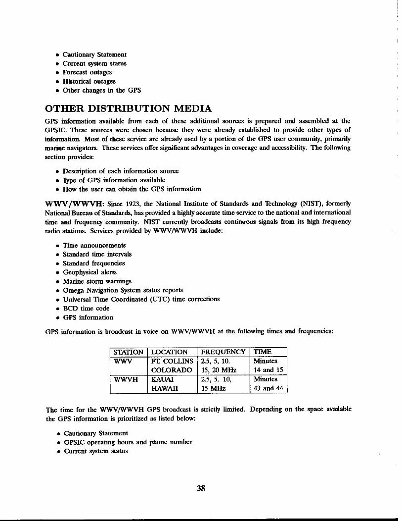
GPS information is broadcast in voice on WWV/WWVH at the following times and frequencies:
Minutes 14 and 15
2.5, 5. 10, Minutes 43 and 44
The time for the WWV/WWVH GPS broadcast is strictly limited. Depending on the space available the GPS information is prioritized as listed below:
Cautionary Statement GPSIC operating hours and phone number Current system status

Forecast outages Other changes in GPS Status
USCG AND DMA MIB: USCG Marine Information Broadcasts and DMA Broadcast Warnings are methods by which important maritime navigation information is disseminated in the most expedient manner. This system covers a variety of topics of interest to mariners including:
Status of navigation aids Weather Search and Rescue (SAR) operations Militaly exercises Marine obstructions Ice reports Changes in channel conditions Important bridge information
Within the United States, the U.S. Coast Guard and the Defense Mapping Agency Hydrographiflopo- graphic Center (DMAHTC) are responsible for broadcasting navigation information described above.
The Coast Guard provides vital maritime information in voice format via an established system of VHF and HF radio broadcasts. These Marine Information Broadcasts (MIB) include the following types of messages:
Urgent Messages concern the safety of a person, ship, aircraft or other vehicle.
Safety Messages contain important navigational or meteorological warnings that cannot be delayed because of hazardous conditions.
Scheduled Broadcasts include:
Notice to Mariners (NTM) Hydrographic information Storm warnings Advisories Other important marine information Safety and urgent messages which remain in effect
Cancellation Messages are sent by the originator to cancel previous broadcast when action is no longer necessary.
USCG Marine Information Broadcasts are issued via voice and continuous wave (CW) transmissions. The following table outlines the MIB frequencies:
Broadcasts are scheduled several times a day depending on the location of the broadcasting site. Stations designated to make regularly scheduled broadcasts are listed in the Coast Guard Radio Frequency Plan. The length of messages broadcast is kept to a minimum.
VHF-FM, Cha 16, Cha 22A Mf 2182 and 2670 H z
HF-CW 590 kHz
.
Information that applies to inland waters seaward to 25 nautical miles. Duplicates VHF-FM broadcasts and additional cover waters out to 200 nautical miles Info that applies to waters from the coastline to 200 nautical miles off shore

DMAHTC is responsible for broadcasting navigation information concerning the "high seas". Information is provided in message format via an established system of message dissemination. DMA broadcasts are known as NAVAREA, HYDROLANT, or HYDROPAC and are generally geared to the deep draft mariner.
DMAHTC also publishes a weekly Notice to Mariners (NTM) containing USCG Marine Information Broadcasts and DMA Broadcast Warnings for a seven day period.
GPS status information is found in Section III of the Notice to Mariners, which summarizes voice or data broadcast warnings.
Additional information on the DMA Notice to Mariners Information is available from:
6500 Brooks Lane Wahington, D.C. 20315-0030
DMA NAVINFONET: In carlying out its mission to produce Notices to Mariners, DMA has developed a data base called Automated Notice to Mariners System (ANMS). This data base contains information dealing with navigational safety. It is a supplemental source of up-to-date maritime information for the user. The software developed for this data base provides remote query capabilities which DMA makes available to the entire maritime community through the Navigation Information Network (NAVINFONET). NAVINFONET provides information in data format via telephone modem. Information includes:
Chart Corrections Broadcast Warnings MARAD Advisories DMA List of Lights Anti-Shipping Activities Messages Oil Drill Rig locations Corrections to DMA ~ ~ d r o ~ r a ~ h i c Product Catalogs U.S. Coast Guard Light Lists & GPS
The following GPS information is available from the DMA NAVINFONET under item 8 in the bulletin board menu:
Cautionary Statement Current system status Forecast outages Historical outages Almanac data Civil GPS Service information
Users must register for the NAVINFONET bulletin board off-line before they will be granted access to the system. For a user ID and information book contact DMA at the address listed above:

Attention: MCN/NAVWFONET (301)-227-3296
NAVTEX: NAVTEX is a an internationally adopted radio telex system used to broadcast marine navi- gational warnings and other safety related information to ships. This system assures worldwide coverage by transmitting on an international frequency of 518 KHz. Vessels' NAVTEX receivedteleprinters are permanently tuned to the worldwide frequency and remain on standby to receive and print out all the messages automatically. Navigation information broadcasted through NAVTEX includes:
Notices to mariners Weather warnings and forecasts Ice warnings Other marine information
Coast Guard Atlantic and Pacific Area Commanders coordinate NAVTEX broadcasts transmitted by all Coast Guard Communications stations. NAVTEX messages are normally broadcasted four times a day which may be increased to six broadcasts with a maximum duration of 40 minutes.
NAVTEX messages are categorized by subject area. GPS status messages are in NAVTEX category "J". GPS information available from NAVTEX includes the following:
Cautionary Statement Current system status Forecast outages Other changes in GPS Status
CONTINGENCY PLAN FOR LOSS OF GPSIC COMMUNI- CATIONS If communications with the GPSIC were disrupted for an extended period of time (as might happen with a fire or similar casualty), we would announce the problem on the W W V W H radio broadcasts, at the times normally set aside for GPS information. If GPSIC services were set up at an interim location, the new phone numbers would be announced on W W V W H .
Users can hear WWV broadcasts by phone, as well as radio at 14 - 15 minutes past the hour: (303)-499-7111 - PUBLICATIONS AVAILABLE FROM THE GPSIC The GPSIC publishes documents which provide detailed information about GPS, other radionavigation systems, the GPS Information Center and how to obtain these services. The following table describes the GPSIC publications available:

The GPSIC distributes documents provided by other GPS interested organizations. The following table describes other GPS publications available through the GPSIC:
PUBLICATION GPSIC USERS MANUAL
GPSIC BROCHURE GPS FACTS & FIGURES
DGPS BROCHURE OMEGA FACTS & FIGURES LORAN C FACTS & FIGURES RADIOBEACON FACTS & FIGURES
DESCRIPTION Provides detailed instructions on the access and use of the services available at the GPSIC Describes information services provided by the GPSIC Describes the system, its concept, accuracies and applications Describes the US Coast Guard's Differential GPS Project Describes the OMEGA Radionaviagation system Describes LORAN C Describes Radiobeacons
GPS ROAD SHOW In an effort to make the public aware of the services offered by the GPSIC, the GPSIC sets up a GPS display at trade shows throughout the United States. The GPSIC staff distributes brochures and answers questions about GPS in order to educate users about the system.
PUBLICATION NAVSTAR GHPS USER EQUIPMENT
GPS NAVSTAR OVERVIEW ICD 200
GPSIC WATCHSTANDERS In addition to updating the OAB, the GPSIC watchstander responds to individual user inquiries, comments, and concerns about civil access to, and use of, the GPS. The GPSIC now has watchstanders on duty 24 hours a day, 7 days a week, so this service is available anytime. Most inquiries can be answered immediately over the phone. Some technical questions or requests are referred to a more authoritative source.
If you would like to comment on any of these services or ask questions about present or future services write to: Commanding Officer (GPSIC), US Coast Guard Omega Navigatin System Center, 7323 Telegraph Road, Alexandria, Virgibia 22310-3998, Tel. (703)-866-3806, FAX (703)-866-3825.
PUBLISHER JPO
JPO JPO
CIVIL GPS SERVICE INTERFACE COMMITTEE (CGSIC) The roles of the Civil GPS Service Interface Committee (CGSIC) are to:
DESCRIPTION Describes the system, equipment, applications and capabilities Provides general information about GPS Technical information about the GPS signal-to-receiver interface
Provide a forum for exchanging technical information in the civil GPS user community regarding GPS information needs

Identify types of information and methods of distribution to the civil GPS user community Identify any issues that may need resolution by the CGS program office
The CGSIC will work with the following organizations:
U.S. Coast Guard Office of Navigation Safety and Watemay Services (Civil GPS Program Office) DOT Navigation Working Group Joint DODDOT Radionavigation Working Group
The Civil GPS Service Interface Committee is comprised of representatives from relevant private, government, and industry user groups, both U.S. and international.
The CGSIC consists of:
General Committee Three Subcommittees
The Committee is jointly chaired by the U.S. Coast Guard and the DOT Research and Special Programs Administration (RSPA). The joint chair is based on the USCG being DOT'S lead agency for the civil GPS service which includes the government's interface with civil GPS users, and RSPA's responsibility to coordinate intermodal navigation planning with DOD.
The Civil GPS Service Interface Committee may create subcommittees to identify specific areas of civil GPS user information needs and facilitate technical information exchange as required. Standing subcommittees have been established for:
Timing Information International Information Reference Station, Technology, and Applications
The International Information Subcommittee (IISC) of the Civil GPS Service Interface Committee is investigating the feasibility of a regional international information media. The GPSIC would provide the OAB into an electronic mailbox designated, controlled, and financed by the IISC.
The Civil GPS Service Interface Committee meets as necessary to exchange technical information regarding civil GPS information needs. . For additional information on the CGSIC, contact the GPS Information Center.
DIFFERENTIAL GPS (DGPS) Consistent with its role as the civil interface for GPS, the U.S. Coast Guard has a research and development project to develop an extension of GPS, known as differential GPS (DGPS). This is an enhancement to the Standard Positioning Service (SPS) which should achieve accuracies of 10 meters or better for civil users in the maritime regions of the United States.
Based on encouraging results of operational testing of a prototype reference station, a project has been initiated to implement DGPS in U.S. near-coastal areas to improve upon current harbor and harbor-approach navigation accuracy. Project plans are being formulated. Additional prototypes began operation during SeptembedOctober 1991. If fully funded, an operational system is expected by 1996.
For additional information on DGPS, contact: Commandant (G-NRN), US Coast Guard, 2100 2nd Street, S.W., Washington, D.C., Tel. (202)-267-0283, FAX. (202)-267-4427.

PRECISE POSITIONING SERVICE PROGRAM OFFICE (PP- SPO) The Precise Positioning Service Program Office (PPSPO) will administer civil applications and collect fees for access to encoded Precise Positioning Service (PPS) capabilities.
The Government will publish detailed guidance for users interested in requesting access to PPS once policy is established for the following:
Submitting applications a Granting approval for user access
Establishing operational procedures and compliance requirements for accessing data from the GPS PPS
The Federal Radionavigation Plan (FRP) contains general criteria for qualified civil use of PPS. Access determination will be made on a case by case basis. The following criteria may be refined as Government policy is developed:
Access is in the U.S. national interest a Security requirements can be met
There are no other means reasonably available to the civil user to obtain a capability equivalent to that provided by the GPS PPS
For additional information on the PPSPO, contact Commandant (G-NRN) at the address listed above or telephone: Commandant (G-NRN), TEL. (202)-267-0298, FAX (202)-267-4427.
FEDERAL RADIONAVIGATION PLAN (FRP) The Federal Radionavigation Plan (FRP) contains the official statement of government policy on civil use of GPS. This plan covers other government operated radionavigation systems in addition to GPS. The FRP is updated biennially. Information provided includes:
Policy and plans for the future radionavigation systems mix GPS System description Table of SPS and PPS signal characteristics
a Various other topics
The text of the Federal Radionavigation Plan (minus tables and illustrations) is available on the GPSIC electronic bulletin board.
To order a copy of the FRP (stock number 008-047-00402-8), contact the U.S. Government Printing Ofice at: Superintendent of Documents, Order Section, U.S. Government Printing Office, Washington, D.C. 20402, Tel. (202)-783-3238.

THE GPSIC QUICK REFERENCE OAB DISTRIBUTION The GPS Infnnnation Center orovides the O~erational Advisocv Broadcasts throurrh the following WS- - . . - - - - -.- - - - -- - - - - --
Service GPSIC
I Watchstander I I I I 1 FAX (703) 866-3825
GPSIC 1 24 Hours a day I Status, Foremist, Outages, NGS / (703) 866-3890
vices:
WWVH I Minutes 43 & 44 1 Status, Forecasts
GPSIC Voice Tape Recording hline WWV
300- 14,400 bps - or - SprintNet (X.25) 3 11020201328 (703 866-3826
2.5, 5, 10, 15, and 20MHz 2.5, 5, 10 and 15
24 hours a day
Minutes 14 & 15
MHz USCG MIB I When I Status, Forecasts I VHF Radio, Marine
Status, Foecasts, Historic
Status, Forecasts
tice to Mariners I Mailed Weekly I DMA Nav- 1 24 hours a day I Status, Forecasts, Historic, 1 (301) 227-3351
DMA Broadcast Warnings DMA Weekly No-
infonet Automated Notice to Mariners System
Almanacs
Broadcasted When Broadcasted Published and
300 BAUD (301) 227-5925 1200 BAUD (301) 227-4360 2400 BAUD
1 For More Information CaU 1 (301) 227-3296 Navtex Data I When Broad- I Status, Forecasts, Outages 1 518 kHz
Status, Forecasts, Outages
Status, Forecasts, Outages
Band
(301) 227-3126

QUESTIONS AND ANSWERS
Mr. R. Langley, Univcrsityof New Bnmmick The United States Naval Observatory automated data service has a link to the Internet computer communications network. Those of us who are on that network would find it convenient to have that information on Internet. Are there any plans for you to interface with the network?
Lt. L. Bamdt, USCG: We have looked at interfacing with Internet, or other public data network, and it is something we have budgeted for. We are experiencing budget problems, just like any other federal agency at this time. I expect that we will have another public data network connection. We are already connected to Sprintnet which has helped a lot of our overseas customers who are having integrity problems. Also, our phone numbers will change in January, 1993. They will be supplied in a press release.
Question: Is it possible to get access to NANU news in real time?
Lt. L Bamdt: I would defer that to someone from the master control station. We have been told that what we do is an advisory service and the way they send that through the auditing system it is not going to be available to civil users in real time. They are working on a warm system. I do not even think that is going to be close to real time. Could someone from the National Control Station maybe help me out?
Comment: That is true; that is the way we do business today. The NANU news is not real time. There is automation being looked at in development, but it is not on the near term horizon. People are finding ways to get that information, in terms of satellite help from the almanac data as broadcast. We recently tried to establish some rules in terms of things we know are going to happen. For instance we are going to do a Delta V this Friday. If anybody cared about which means the clocks will be off, by publishing the information two weeks in advance, we hope to minimize the unexpected outages. If we build in the ones that occur in one satellite at a time, they should be transparent with the number of satellites available, but there is a more real time system coming on line. We will continue to do a better job at forecasting and also at localizing those forecasts; so we are working at it.