US 380 Collin County Feasibility Study
151
US 380 Collin County Feasibility Study Final Report and Implementation Plan CSJ’s: 0135-11-022, 0135-02-059, 0135-03-048, 0135-04-032, 0135-05-026 March 2020
Transcript of US 380 Collin County Feasibility Study
US 380 Collin County Feasibility Study Final Report and Implementation Plan CSJ’s: 0135-11-022, 0135-02-059, 0135-03-048, 0135-04-032, 0135-05-026 March 2020

March 2020 1
US 380 Collin County Feasibility Study Final Report and Implementation Plan
TABLE OF CONTENTS
1.0 INTRODUCTION ................................................................................................................ 6
2.0 BACKGROUND ................................................................................................................. 6
2.1 PROJECT OBJECTIVE .......................................................................................................... 6 2.2 STUDY AREA ...................................................................................................................... 6 2.3 EXSITING CONDITIONS ........................................................................................................ 7 2.4 PROJECT HISTORY & PREVIOUS STUDIES .............................................................................. 8
Previous TxDOT Feasibility Study ................................................................................ 8 Collin County Strategic Roadway Plan ......................................................................... 9
2.5 REGIONAL PLANNING CONTEXT .......................................................................................... 10 2.6 EXSITING AND PLANNED TRANSPORTATION SYSTEM ............................................................ 10 2.7 OTHER MAJOR ROADWAYS – EXISTING AND PLANNED .......................................................... 11
Collin County Outer Loop .......................................................................................... 13 2.8 EXISTING FUNCTIONAL CLASSIFICATION, TRAFFIC VOLUMES, AND SPEED LIMITS ..................... 14 2.9 EXISTING FREEWAY CORRIDORS IN NEIGHBORING COUNTIES ................................................ 14
3.0 UNDERSTANDING FUTURE NEEDS ............................................................................. 15
3.1 PROJECTED REGIONAL POPULATION AND EMPLOYMENT GROWTH ......................................... 15 3.2 EXISTING AND PROJECTED TRAVEL DEMAND ....................................................................... 16 3.3 EXISTING AND PROPOSED TYPICAL SECTIONS ..................................................................... 17 3.4 PHYSICAL CONSTRAINTS ................................................................................................... 17 3.5 SAFETY ........................................................................................................................... 17
4.0 DETERMINING ROADWAY TYPE OPTIONS ................................................................. 18
4.1 MODES OF TRANSPORTATION TO RELIEVE CONGESTION ....................................................... 18 4.2 US 380 ROADWAY OPTIONS ............................................................................................... 18 4.3 TRAVEL DEMAND MODELING .............................................................................................. 20 4.4 REGIONAL TRAFFIC ANALYSIS TO DETERMINE NEED FOR FREEWAY ....................................... 21
Existing Traffic ......................................................................................................... 21 Future Traffic ........................................................................................................... 22
5.0 FREEWAY ALIGNMENT ANALYSIS .............................................................................. 23
5.1 INITIAL ALIGNMENTS ......................................................................................................... 23 Traffic Analysis to Determine Viable Alignments .......................................................... 25
Other Analysis to Determine Viable Alignments ................................................... 26 5.2 VIABLE ALIGNMENTS – PRESENTED SPRING 2018 ................................................................ 27 5.3 REFINING VIABLE ALIGNMENTS – SPRING 2018 TO FALL 2018 ................................................ 28
Evaluation Categories ............................................................................................... 30 Traffic Analysis to Refine Viable Alignments ............................................................... 32 US 380 Regionwide Traffic Analysis Results ............................................................... 33 US 380 Countywide Traffic Analysis Results ............................................................... 37 US 380 Corridor Only Traffic Analysis Results ............................................................ 41 US 380 Segment Traffic Analysis Results ................................................................... 43

March 2020 2
US 380 Collin County Feasibility Study Final Report and Implementation Plan
5.4 DEVELOPING A RECOMMENDED ALIGNMENT – FALL 2018 TO SUMMER 2019 ........................... 46 Traffic Analysis Summary ......................................................................................... 47 New Alignment Segments – Spring 2018 .................................................................... 48
Red E .............................................................................................................. 48 Red D .............................................................................................................. 51 Green Alignment North Shift – Hardin to US 75 .................................................... 55 Segment Evaluations – Recommended Alignment Deciding Factors ...................... 56 Denton County Line to Coit Road ....................................................................... 56 Coit to FM 1827 ................................................................................................ 59 FM 1827 to CR559 ............................................................................................ 65 CR 559 to Hunt County ...................................................................................... 67
6.0 ENVIRONMENTAL OVERVIEW ...................................................................................... 67
6.1 LAND USE - EXISTING AND PLANNED, AIRPORT EXPANSION ................................................... 67 6.2 DEVELOPMENT AND POSSIBLE DISPLACEMENTS – RESIDENTIAL AND COMMERCIAL ................. 70 6.3 POTENTIAL HISTORIC RESOURCES ..................................................................................... 70
Parks and Recreation Areas ...................................................................................... 73 Natural Habitats ................................................................................................ 79 Socio-Economic Issues ..................................................................................... 79
6.4 INITIAL NOISE ANALYSIS .................................................................................................... 82
7.0 PUBLIC INVOLVEMENT AND STAKEHOLDER OUTREACH ....................................... 85
7.1 PUBLIC MEETINGS AND MAPOS ......................................................................................... 86 7.2 COLLECTION OF PUBLIC COMMENTS ................................................................................... 87 7.3 HOW INPUT IMPACTED THE STUDY ..................................................................................... 87 7.4 LOCAL GOVERNMENT COORDINATION ................................................................................. 89
Collin County ........................................................................................................... 89 Town of Prosper ....................................................................................................... 89 City of Frisco ........................................................................................................... 90 City of McKinney ...................................................................................................... 90 Town of New Hope ................................................................................................... 91 City of Lowry Crossing .............................................................................................. 91 Town of Fairview ...................................................................................................... 91 City of Princeton ....................................................................................................... 91 City of Farmersville ................................................................................................... 91
7.5 STATE AND FEDERAL AGENCY COORDINATION..................................................................... 91 7.6 STAKEHOLDER WORK GROUPS .......................................................................................... 92 7.7 ONLINE OUTREACH AND WEBSITE ...................................................................................... 92 7.8 DATABASE/MAILING LIST ................................................................................................... 98
8.0 ECONOMIC ANALYSIS ................................................................................................... 99
8.1 ECONOMIC IMPACT ANALYSIS BY CITY (SALES AND PROPERTY TAX) ....................................... 99 8.2 DEVELOPMENT POTENTIAL ANALYSIS ............................................................................... 101
9.0 PROJECT IMPLEMENTATION PLAN ........................................................................... 104
9.1 NEXT STEPS .................................................................................................................. 104
March 2020 3
US 380 Collin County Feasibility Study Final Report and Implementation Plan
Possible Independent Project Segmentation ............................................................. 105 Suggested Construction Phasing ............................................................................. 107
9.2 COST ............................................................................................................................ 108 9.3 FUNDING ....................................................................................................................... 109 9.4 SAFETY AND SHORT TERM / INTERIM PROJECTS ................................................................ 110
Recommended Future Feasibility Studies on Adjacent Corridors ................................ 110 9.5 POTENTIAL MINIMIZATION OF EFFECTS AND MITIGATION STRATEGIES ................................... 110
APPENDIX A - LOCAL GOVERNMENT COORDINATION…………………………………….112
APPENDIX B - STAKEHOLDER MEETINGS…………………………………………………….133
APPENDIX C - SURVEY FORMS……………………………………………..…………….……..142
APPENDIX D - COLLIN COUNTY THOROUGHFARE PLAN MAP…….…..………….……..148

March 2020 4
US 380 Collin County Feasibility Study Final Report and Implementation Plan
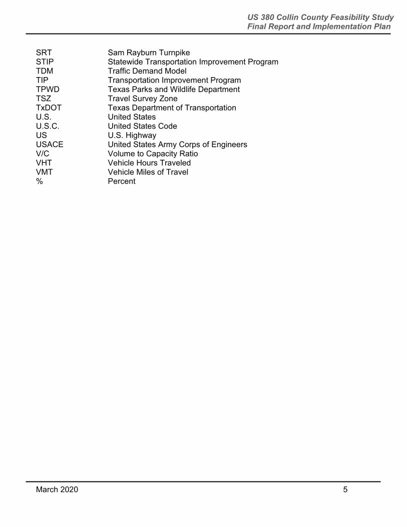
List of Acronyms Acronym Definition AADT Annual Average Daily Traffic CAAA Clean Air Act Amendments of 1990 CFR Code of Federal Regulations CPI Consumer Price Index CSJ Control Section Job DFW Dallas-Fort Worth DNT Dallas North Tollway DOT Department of Transportation EA Environmental Assessment EIS Environmental Impact Statement EJ Environmental Justice ETJ Extraterritorial Jurisdiction FAQ Frequently Asked Question FEMA Federal Emergency Management Agency FHWA Federal Highway Administration FM Farm to Market Road GIS Geographic Information System HHS Health and Human Services HOA Homeowners Association ISD Independent School District LEP Limited English Proficiency LWCF Land and Water Conservation Fund LOS Level of Service MAPO Meeting of Affected Property Owners mph miles per hour MPO Metropolitan Planning Organization MTP Metropolitan Transportation Plan NCTCOG North Central Texas Council of Governments NEPA National Environmental Policy Act of 1969 NHPA National Historic Preservation Act NPS National Park Service NRHP National Register of Historic Places NTMWD North Texas Municipal Water District NTTA North Texas Tollway Authority PGBT President George Bush Turnpike ROW Right of way RTC Regional Transportation Council SAFETEA-LU Safe, Accountable, Flexible, Efficient Transportation Equity Act: A Legacy
for Users SH State Highway SIP State Implementation Plan
March 2020 5
US 380 Collin County Feasibility Study Final Report and Implementation Plan
SRT Sam Rayburn Turnpike STIP Statewide Transportation Improvement Program TDM Traffic Demand Model TIP Transportation Improvement Program TPWD Texas Parks and Wildlife Department TSZ Travel Survey Zone TxDOT Texas Department of Transportation U.S. United States U.S.C. United States Code US U.S. Highway USACE United States Army Corps of Engineers V/C Volume to Capacity Ratio VHT Vehicle Hours Traveled VMT Vehicle Miles of Travel % Percent

March 2020 6
US 380 Collin County Feasibility Study Final Report and Implementation Plan
1.0 INTRODUCTION
This report documents findings from the TxDOT Dallas District Collin County US 380 feasibility study and outlines an implementation plan for the project.
Working with Collin County and regional leaders, TxDOT started this current feasibility study in June 2017 to identify a recommended corridor and appropriate roadway type. The roadway would need to accommodate the projected east-west travel demand and provide a safe and accessible facility to support east-west mobility across Collin County in the year 2045 and beyond. As the County’s population grows, the options to build a new roadway or expand the existing US 380 become more limited and potential impacts to residential and commercial developments increase. The intent of the feasibility study was to start to identify a roadway alignment or alignments to serve as a blueprint to begin land banking or preserving land now.
During the study, TxDOT developed and evaluated roadway options and many potential alignment options, including utilizing the existing alignment and new location alignments, based on engineering factors and environmental constraints.
After two years of study, TxDOT publicly announced its recommended freeway alignment in May 2019.
2.0 BACKGROUND
2.1 PROJECT OBJECTIVE The objective of the feasibility study was to perform a needs assessment and analyze potential roadway options. That could include improving the existing US 380 alignment or utilizing new alignments. A feasibility study is one planning tool that TxDOT uses when a project is in the very early stages of development. It helps determine if the project should move on to more advanced phases of project development such as more in-depth environmental analysis, public involvement, schematic design and right of way mapping. The reason this type of study is done is to identify high level or critical elements of engineering, impacts to stakeholders and the public, and the economic feasibility of potential new roadways or improvements to existing roadways. 2.2 STUDY AREA This study focused on identifying a recommended corridor location and appropriate roadway type in Collin County. Figure 2-1 displays the feasibility study area. Study area municipalities included Prosper, Frisco, Celina, McKinney, New Hope, Lowry Crossing, Melissa, Fairview, Princeton, and Farmersville.
The existing US 380 alignment is approximately 32 miles long. Five control-section-jobs (CSJ) are included in the study area and they include the following:
Denton County line to Preston Road (CSJ 0135-11-022)
Preston Road to SH 5 (CSJ 0135-02-059)

March 2020 7
US 380 Collin County Feasibility Study Final Report and Implementation Plan
SH 5 to FM 982 (CSJ 0135-03-048)
FM 982 to Hamilton Street (CSJ 0135-04-032)
Hamilton Street to the Hunt County line (CSJ 0135-05-026)
US 380 operates as an important east-west regional connector between the cities of Denton and Greenville. TxDOT is also conducting a similar feasibility study in Denton County. 2.3 EXISTING CONDITIONS US 380 is currently classified as a principal arterial with a varying speed limit of 45-60 miles per hour (mph). The current alignment consists of 4-6 lanes with a right of way width of approximately 130-180 feet.
The segment from just west of Dallas North Tollway (DNT) to just east of SH 289 (Preston Road) was recently reconstructed and contains 6-lane mainlanes (designed for 45 mph speeds), 2-lane frontage roads, and ramps. It also includes grade-separated interchanges at DNT and SH 289. The segment from just east of SH 289 to Airport Drive is a 6-lane arterial with an interchange at US 75 and SH 5. Between Airport Drive to the Hunt County line, US 380 is four lanes and there is an interchange at SH 78. Traffic is over capacity for most of US 380 in the study area during rush hours and operates at a level of service F.
Figure 2-1: Feasibility Study Area
March 2020 8
US 380 Collin County Feasibility Study Final Report and Implementation Plan
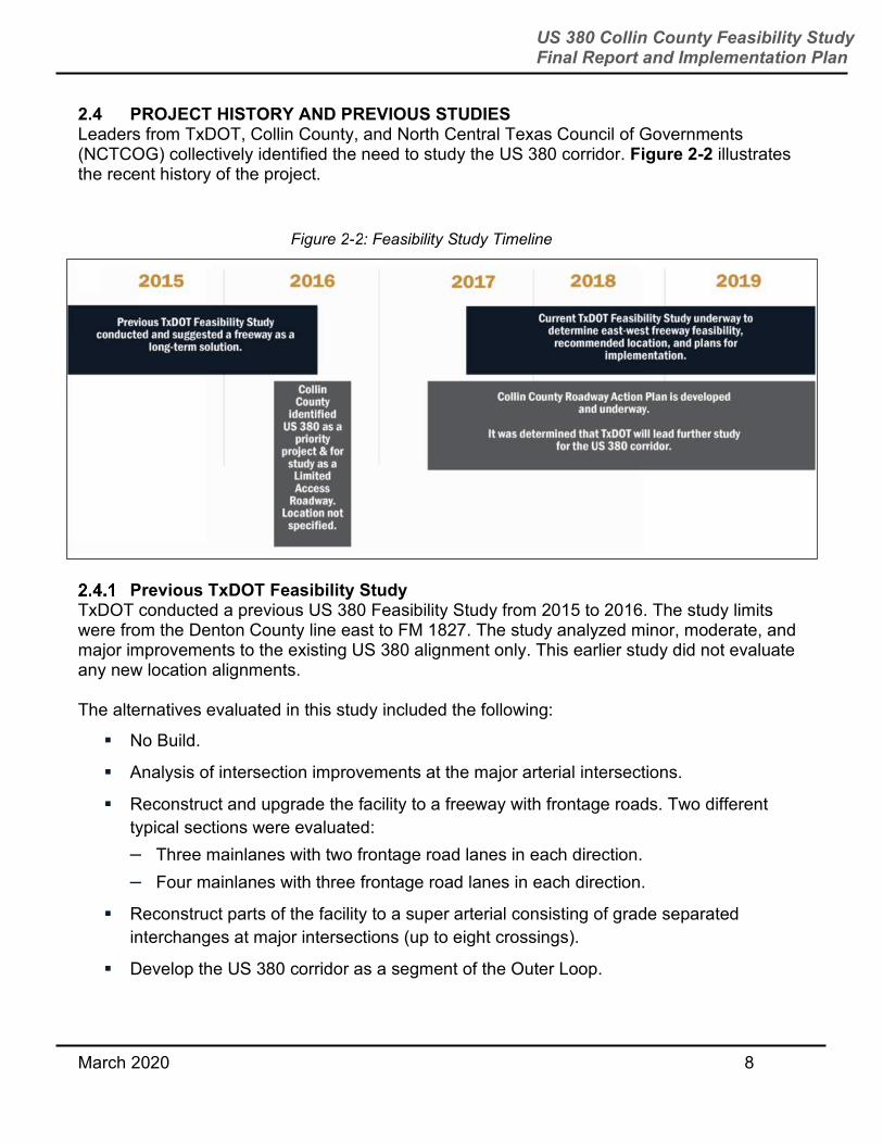
2.4 PROJECT HISTORY AND PREVIOUS STUDIES Leaders from TxDOT, Collin County, and North Central Texas Council of Governments (NCTCOG) collectively identified the need to study the US 380 corridor. Figure 2-2 illustrates the recent history of the project.
Previous TxDOT Feasibility Study
TxDOT conducted a previous US 380 Feasibility Study from 2015 to 2016. The study limits were from the Denton County line east to FM 1827. The study analyzed minor, moderate, and major improvements to the existing US 380 alignment only. This earlier study did not evaluate any new location alignments. The alternatives evaluated in this study included the following:
No Build.
Analysis of intersection improvements at the major arterial intersections.
Reconstruct and upgrade the facility to a freeway with frontage roads. Two different
typical sections were evaluated:
– Three mainlanes with two frontage road lanes in each direction.
– Four mainlanes with three frontage road lanes in each direction.
Reconstruct parts of the facility to a super arterial consisting of grade separated
interchanges at major intersections (up to eight crossings).
Develop the US 380 corridor as a segment of the Outer Loop.
Figure 2-2: Feasibility Study Timeline
March 2020 9
US 380 Collin County Feasibility Study Final Report and Implementation Plan
The final recommendation from this previous TxDOT feasibility study was that a freeway “provides the best mobility and safety, and addresses the long-term needs of the communities” but “an additional detailed study covering Denton, Collin, and Hunt Counties is likely necessary” to develop a plan for the future of US 380.
The final report from the study can be found at http://www.keepitmovingdallas.com/sites/default/files/docs/AECOMM%20US%20380%20Feasibility%20Study%20Report%20and%20Appendices.pdf
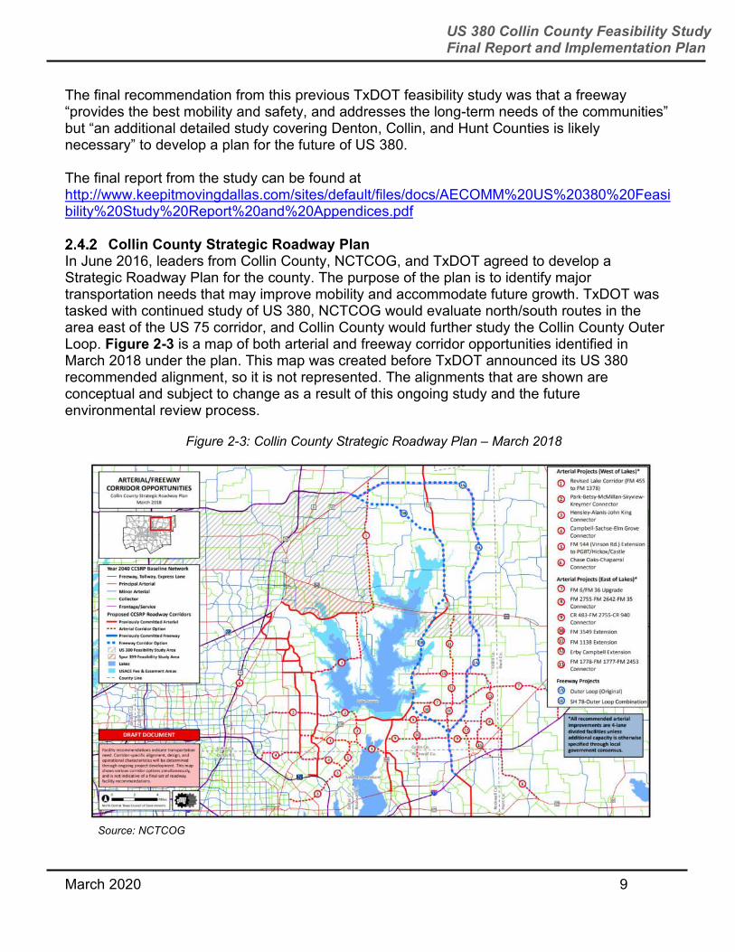
Collin County Strategic Roadway Plan In June 2016, leaders from Collin County, NCTCOG, and TxDOT agreed to develop a Strategic Roadway Plan for the county. The purpose of the plan is to identify major transportation needs that may improve mobility and accommodate future growth. TxDOT was tasked with continued study of US 380, NCTCOG would evaluate north/south routes in the area east of the US 75 corridor, and Collin County would further study the Collin County Outer Loop. Figure 2-3 is a map of both arterial and freeway corridor opportunities identified in March 2018 under the plan. This map was created before TxDOT announced its US 380 recommended alignment, so it is not represented. The alignments that are shown are conceptual and subject to change as a result of this ongoing study and the future environmental review process.
Source: NCTCOG
Source: NCTCOG
Figure 2-3: Collin County Strategic Roadway Plan – March 2018
March 2020 10
US 380 Collin County Feasibility Study Final Report and Implementation Plan
2.5 REGIONAL PLANNING CONTEXT The NCTCOG is a voluntary association of, by and for local governments, and was established to assist local governments in planning for common needs, cooperating for mutual benefit, and coordinating for sound regional development. NCTCOG serves a 16-county region of North Central Texas, which is centered around the two urban centers of Dallas and Fort Worth. NCTCOG has over 230 member governments including 16 counties, numerous cities, school districts, and special districts. The NCTCOG serves as the MPO for regional transportation planning in the DFW area. The RTC is the independent transportation policy body of the MPO
and is comprised of elected officials and appointed staff representing the counties, municipalities, and transportation providers in the region. Since the early 1970s, MPOs have had the responsibility of developing and maintaining a metropolitan transportation plan (MTP). The MTP is a federally mandated document that serves to identify transportation needs and guides federal, state, and local transportation expenditures. The MTP includes over 70 policies set by the RTC to help guide the development, implementation, and operation of transportation projects. For example, RTC policy FT3-008 encourages the early preservation of ROW in recommended corridors, and FT3-009 encourages the preservation of ROW in all freeway/tollway corridors to accommodate future transportation needs, to accommodate the ultimate new location, access controlled transportation facility that would meet the long-term needs of the region.
Mobility 2045 is the defining vision or plan for transportation systems and services in the Dallas-Fort Worth Metropolitan Area. Serving as a guide for the expenditure of State and federal funds through the year 2045, the Plan addresses regional transportation needs that are identified through forecasting current and future travel demand, developing and evaluating system alternatives, and selecting those options which best meet the mobility needs of the region.
Transportation plans such as Mobility 2045, according to the Safe, Accountable, Flexible, Efficient Transportation Equity Act: a Legacy for Users (SAFETEA-LU) metropolitan planning regulations, must be “fiscally constrained,” that is, based on reasonable assumptions about future transportation funding levels. Because the DFW area is designated as moderate non-attainment areas for the 8-hour ozone standard, the Clean Air Amendments Act of 1990 (CAAA) requires the transportation plan to be in conformity with the State Implementation Plan (SIP) for air quality to demonstrate that projects in the MTP meet air quality goals.
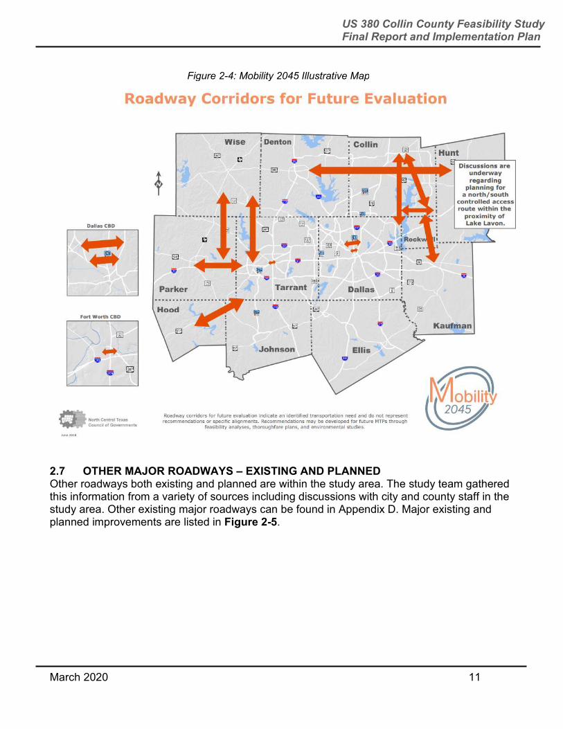
2.6 EXISTING AND PLANNED TRANSPORTATION SYSTEM Within the study area, there are numerous existing and planned transportation facilities that provide access and circulation. In the Mobility 2045 plan, NCTCOG identified future regional roadway corridors for which a need exists. Figure 2-4 shows the Mobility 2045 illustrative map that includes an east-west Collin County corridor study. TxDOT will work with NCTCOG to incorporate the recommended alignment into the next MTP.
March 2020 11
US 380 Collin County Feasibility Study Final Report and Implementation Plan
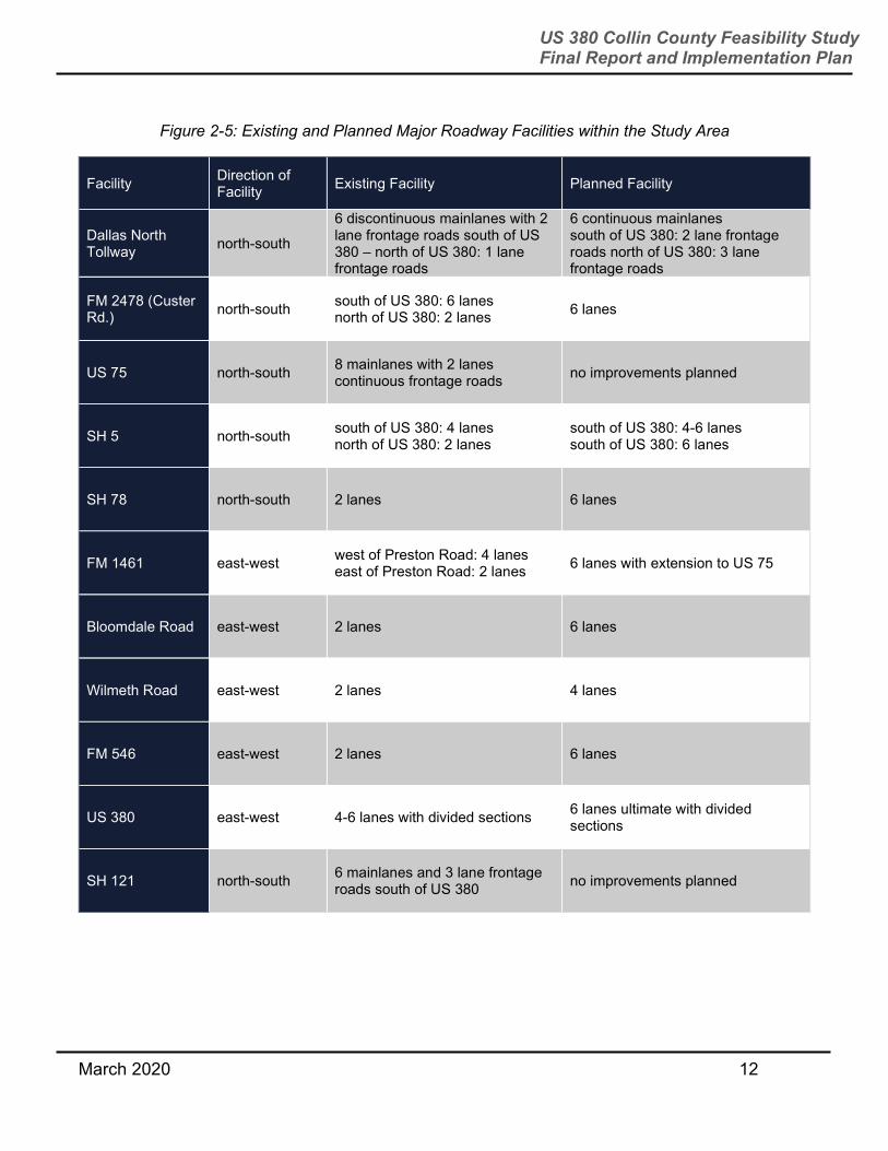
2.7 OTHER MAJOR ROADWAYS – EXISTING AND PLANNED Other roadways both existing and planned are within the study area. The study team gathered this information from a variety of sources including discussions with city and county staff in the study area. Other existing major roadways can be found in Appendix D. Major existing and planned improvements are listed in Figure 2-5.
Figure 2-4: Mobility 2045 Illustrative Map
March 2020 12
US 380 Collin County Feasibility Study Final Report and Implementation Plan
Figure 2-5: Existing and Planned Major Roadway Facilities within the Study Area
Facility Direction of Facility
Existing Facility Planned Facility
Dallas North Tollway
north-south
6 discontinuous mainlanes with 2 lane frontage roads south of US 380 – north of US 380: 1 lane frontage roads
6 continuous mainlanes
south of US 380: 2 lane frontage roads north of US 380: 3 lane frontage roads
FM 2478 (Custer Rd.)
north-south south of US 380: 6 lanes
north of US 380: 2 lanes 6 lanes
US 75 north-south 8 mainlanes with 2 lanes continuous frontage roads
no improvements planned
SH 5 north-south south of US 380: 4 lanes
north of US 380: 2 lanes
south of US 380: 4-6 lanes
south of US 380: 6 lanes
SH 78 north-south 2 lanes 6 lanes
FM 1461 east-west west of Preston Road: 4 lanes
east of Preston Road: 2 lanes 6 lanes with extension to US 75
Bloomdale Road east-west 2 lanes 6 lanes
Wilmeth Road east-west 2 lanes 4 lanes
FM 546 east-west 2 lanes 6 lanes
US 380 east-west 4-6 lanes with divided sections 6 lanes ultimate with divided sections
SH 121 north-south 6 mainlanes and 3 lane frontage roads south of US 380
no improvements planned
March 2020 13
US 380 Collin County Feasibility Study Final Report and Implementation Plan
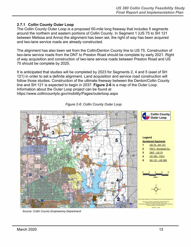
Collin County Outer Loop The Collin County Outer Loop is a proposed 50-mile long freeway that includes 5 segments around the northern and eastern portions of Collin County. In Segment 1 (US 75 to SH 121 between Melissa and Anna) the alignment has been set, the right of way has been acquired and two-lane service roads are already constructed. The alignment has also been set from the Collin/Denton County line to US 75. Construction of two-lane service roads from the DNT to Preston Road should be complete by early 2021. Right of way acquisition and construction of two-lane service roads between Preston Road and US 75 should be complete by 2025. It is anticipated that studies will be completed by 2023 for Segments 2, 4 and 5 (east of SH 121) in order to set a definite alignment. Land acquisition and service road construction will follow those studies. Construction of the ultimate freeway between the Denton/Collin County line and SH 121 is expected to begin in 2037. Figure 2-6 is a map of the Outer Loop. Information about the Outer Loop project can be found at https://www.collincountytx.gov/mobility/Pages/outerloop.aspx
Figure 2-6: Collin County Outer Loop
Source: Collin County Engineering Department
March 2020 14
US 380 Collin County Feasibility Study Final Report and Implementation Plan
2.8 EXISTING FUNCTIONAL CLASSIFICATION, TRAFFIC VOLUMES, AND SPEED LIMITS
The existing DNT operates as a principal arterial – (other freeways and expressways) with an annual average daily traffic (AADT) of 260,920. Preston Road is a principal arterial with an AADT of approximately 32,000 vehicles and a speed limit of 50-55 mph. Custer Road has an AADT of approximately 22,000 vehicles south of US 380 and approximately 12,000 vehicles north of US 380. It is a principal arterial (other) south of US 380 and a minor arterial north of US 380 with a maximum speed limit of 55 miles per hour. US 75 intersects US 380 near the center of the county and serves as one of the main north-south connectors. It is classified as a principal arterial (other freeways and expressways), has a maximum speed limit of 70 miles per hour, and has an AADT of 134,200 vehicles. SH 5 is a principal arterial (other) with an AADT of 14,500 vehicles south of US 380 and 10,000 vehicles north of US 380. The speed limit for SH 5 varies from 35-50 miles per hour. FM 1827 has a maximum speed limit of 45 miles per hour, is a major collector, and has an AADT of nearly 6,000 vehicles. SH 78 passes through Farmersville. It has an AADT of 9,100 vehicles and is a principal arterial (other) with a maximum speed limit of 50 miles per hour.
2.9 EXISTING FREEWAY CORRIDORS IN NEIGHBORING COUNTIES Collin County has a limited number of existing freeways to service its growing population in comparison to other counties in the DFW region.
Figure 2-7 is an exhibit used by Collin County in 2018 to show existing freeway corridors in the county to service its 2018 population of 949,673. The exhibit also allows shows the same information for the surrounding counties of Denton, Dallas, and Tarrant counties.

March 2020 15
US 380 Collin County Feasibility Study Final Report and Implementation Plan
3.0 UNDERSTANDING FUTURE NEEDS
3.1 PROJECTED REGIONAL POPULATION AND EMPLOYMENT GROWTH Collin County has seen significant growth in its population from 2010-2017 and is projected to see even more in the future. According to the US Census Bureau, there has been a 24 percent increase in Collin County’s population during that timeframe. In 2017, the County’s population was close to 970,000 – making it one of the most populous counties in Texas. According to the Texas State Demographer’s 2014 population projections by migration scenario data, over the next 30 years the County could expect up to a 160-170 percent increase in population. As shown in Figure 3-1, population growth in the County is expected to continue northward and eastward, similar to historical trends. Population projections and city future land use plans point toward denser development between Dallas
Figure 2-7: Collin County Freeways in Comparison to Neighboring Counties
Source: 2018 Collin County Bond Program Presentation
949,673

March 2020 16
US 380 Collin County Feasibility Study Final Report and Implementation Plan
North Tollway and US 75. Current and future residents throughout the county will need access to additional mobility options to keep up with travel demand due to population growth.
3.2 EXISTING AND PROJECTED TRAVEL DEMAND Existing congestion on US 380 during peak travel times is rated in engineering terms as having an “F” level of service. This means that the number of vehicles on the road exceed the capacity of the roadway, causing a significant drop in travel speeds and an increase in congestion or delay in traffic. US 380 has seen a 30 percent increase in the number of vehicles on the road in Collin County from 2010-2016. Areas such as western McKinney and Princeton have shown as much as 45-50 percent increase in traffic volumes during this period. These areas, and others, are only expected to see more and more traffic congestion as the number of vehicles on the road increase. More information about travel demand analysis conducted under this study is available in Section 4.2.
Figure 3-1: Collin County Projected Population Growth
March 2020 17
US 380 Collin County Feasibility Study Final Report and Implementation Plan
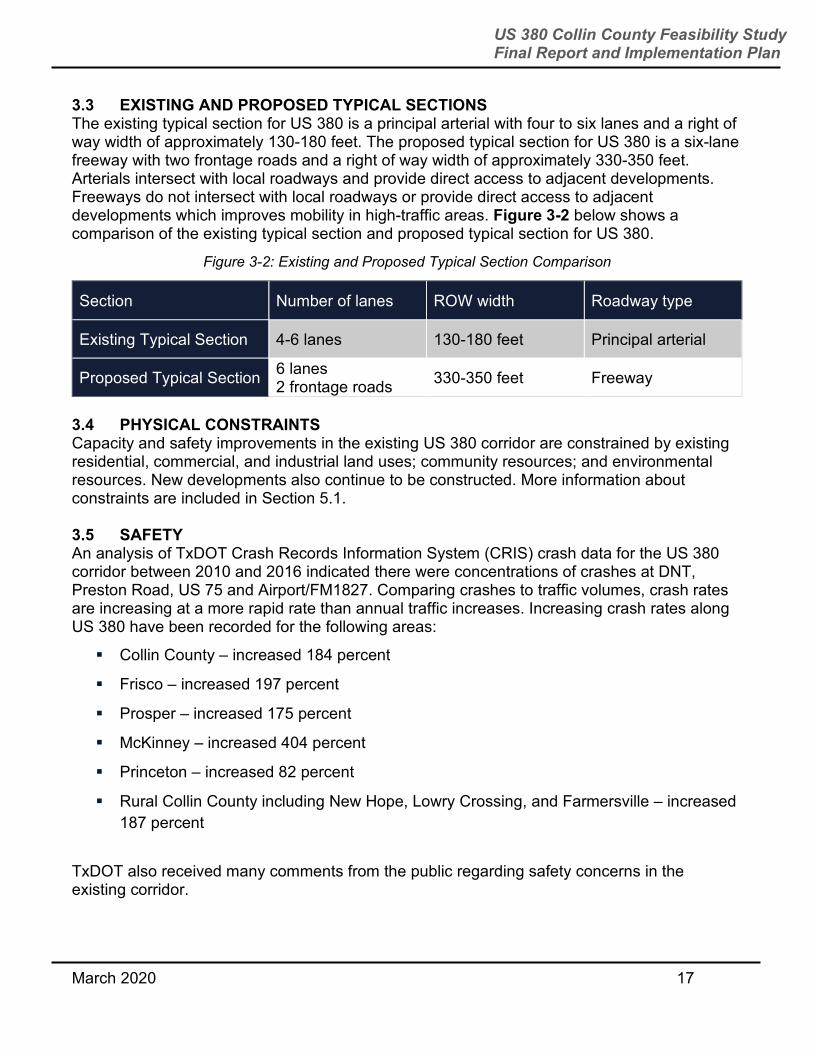
3.3 EXISTING AND PROPOSED TYPICAL SECTIONS The existing typical section for US 380 is a principal arterial with four to six lanes and a right of way width of approximately 130-180 feet. The proposed typical section for US 380 is a six-lane freeway with two frontage roads and a right of way width of approximately 330-350 feet. Arterials intersect with local roadways and provide direct access to adjacent developments. Freeways do not intersect with local roadways or provide direct access to adjacent developments which improves mobility in high-traffic areas. Figure 3-2 below shows a comparison of the existing typical section and proposed typical section for US 380.
Figure 3-2: Existing and Proposed Typical Section Comparison
Section Number of lanes ROW width Roadway type
Existing Typical Section 4-6 lanes 130-180 feet Principal arterial
Proposed Typical Section 6 lanes
2 frontage roads 330-350 feet Freeway
3.4 PHYSICAL CONSTRAINTS Capacity and safety improvements in the existing US 380 corridor are constrained by existing residential, commercial, and industrial land uses; community resources; and environmental resources. New developments also continue to be constructed. More information about constraints are included in Section 5.1. 3.5 SAFETY An analysis of TxDOT Crash Records Information System (CRIS) crash data for the US 380 corridor between 2010 and 2016 indicated there were concentrations of crashes at DNT, Preston Road, US 75 and Airport/FM1827. Comparing crashes to traffic volumes, crash rates are increasing at a more rapid rate than annual traffic increases. Increasing crash rates along US 380 have been recorded for the following areas:
Collin County – increased 184 percent
Frisco – increased 197 percent
Prosper – increased 175 percent
McKinney – increased 404 percent
Princeton – increased 82 percent
Rural Collin County including New Hope, Lowry Crossing, and Farmersville – increased
187 percent
TxDOT also received many comments from the public regarding safety concerns in the existing corridor.

March 2020 18
US 380 Collin County Feasibility Study Final Report and Implementation Plan
4.0 DETERMINING ROADWAY TYPE OPTIONS
4.1 MODES OF TRANSPORTATION TO RELIEVE CONGESTION It is possible that other modes of transportation besides roadways could improve mobility in the region. Pedestrian facilities such as sidewalks and wide outside roadway lanes will be incorporated in future plans to allow for pedestrians and bicyclists to utilize the US 380 corridor. However, bicycle/pedestrian facilities cannot alone relieve congestion. The region is also evaluating northern extensions of existing and future rail corridors, but transit trips only serve a portion of trips that drivers are making. 4.2 US 380 ROADWAY OPTIONS In addition to looking at different transportation modes, TxDOT also considered and publicly presented a variety of roadway options. TxDOT considered how these options might address (or not address) the future needs of the corridor, how they might impact future congestion and safety, and a high-level estimate of how much each option might costs. The roadway options included the following:
No-build option (Figure 4-1) means building no new improvements other than current
planned improvements. Capacity and safety improvements along US 380 are
constrained. Traffic analysis shows that congestion would not be fully addressed, and
that future county population growth and new developments are likely to cause these
issues to progress. Future congestion in peak rush hour periods for this option is rated
in engineering terms, an “F” level of service.
Figure 4-1: No Build Option

March 2020 19
US 380 Collin County Feasibility Study Final Report and Implementation Plan
Grade separated intersections option (Figure 4-2) is also known as overpasses or
underpasses at intersections. Traffic analysis shows that select grade separations have
a small effect on future traffic congestion. Future congestion in peak rush hour periods
is rated in engineering terms, an “F” level of service.
Freeway option (Figure 4-3) is construction of a freeway with 6-lane mainlanes and 2-
lane frontage roads. Traffic analysis shows that current and future congestion would
decrease, and speeds during peak traffic periods and mobility throughout the corridor
would increase. Future congestion in peak rush hour periods is rated in engineering
terms, a “B” level of service.
Figure 4-2: Select Grade Separated Intersections Option

March 2020 20
US 380 Collin County Feasibility Study Final Report and Implementation Plan
4.3 TRAVEL DEMAND MODELING NCTCOG’s Regional Travel Model Mobility 2045 was used to determine the need for the project and viable freeway alignments. The study team utilized two different models in the traffic analysis.
The first model, referred to as the 2045 model, retained demographic data provided by NCTCOG in order to stay consistent with the regionally accepted model.
The second model, referred to as the modified 2045 model, contained adjusted centroid connectors so that each alignment option loaded to the corridor and the overall network appropriately. This was done after evaluating proposed developments in a Travel Survey Zone (TSZ) and accordingly adjusting where the centroid connectors would load the roadways. This also made centroid connectors for the different alignments comparable.
Study performance measures were developed in consultation with TxDOT and NCTCOG. The following performance measures were identified to evaluate how the transportation alignments satisfied the need and purpose for the study.
Vehicle miles of travel (VMT) measures the demand for transportation that is caused by
the distribution of trip origins (e.g., households) and trip destinations (e.g., employment)
and satisfied by the specific transportation network.
Figure 4-3: Freeway Option

March 2020 21
US 380 Collin County Feasibility Study Final Report and Implementation Plan
When compared between scenarios, a lower VMT value is the result of a more efficient
relationship between development patterns and the transportation network. In this
sense, it is a reasonable measurement of sustainability because of its correlation to
greenhouse gas and other emissions, fuel consumption, crashes, and direct user costs.
Vehicle hours traveled (VHT) is calculated from data on speed and miles traveled to
measure the quality of service on a roadway.
Level of service (LOS) is a simple measure of the quality of the vehicle/roadway
component of the transportation system. It is described using letter grades A, B, C, D,
E, and F based on the ratio of travel demand (vehicle miles travelled) to capacity
(vehicle-miles of capacity) for the transportation system in an area. This ratio is also
called the Volume to Capacity (V/C) ratio.
Congestion delay measures the amount of vehicular delay, in hours, encountered by all
vehicles on the roadway network. The delay is based on the difference in actual
(modeled) vehicular speeds and the speed vehicles would travel if there was no
congestion.
Traffic control delay is the portion of the total delay attributed to traffic control
operations. Traffic control delay can be categorized into deceleration delay, stopped
delay, and acceleration delay.
Volume to capacity ratio (V/C) is a measure for roadways, comparing roadway demand
(vehicle volume) with roadway supply (capacity).
Road user cost is the estimated cost to the traveling public resulting from delay along a
road. For this project, the 2017 road user cost of $22.40 per vehicle hour was used.
4.4 REGIONAL TRAFFIC ANALYSIS TO DETERMINE NEED FOR FREEWAY
Existing Traffic Existing traffic volume along US 380 exceeds 49,000 vehicles per day. Figure 4-4 shows an exhibit from NCTCOG that illustrates information sourced from the Transportation Research Board’s Highway Capacity Manual 2010 that has provided NCTCOG staff guidance for the number of lanes warranted by daily traffic volume. Comparing existing traffic volumes to the capacity of different types of roadways can help determine what type of roadways is necessary.
Based on this, existing US 380 would need to be constructed as a freeway. A US 380 freeway would attract traffic from local city streets. It would reduce congestion on the local city streets and shorten travel times within and through Collin County.

March 2020 22
US 380 Collin County Feasibility Study Final Report and Implementation Plan
Future Traffic
As population in and around Collin County grows, east-west travel demand is expected to continue to increase. Based on the NCTCOG Mobility 2045 model, travel demand along US 380 is projected to average 86,300 vehicles per day in 2045 for entire county and average daily traffic could be as high as 101,000 in some locations. According to the information in Figure 4-4, US 380 is warranted to be at least a 6-lane freeway with three lanes in each direction. Figure 4-5 shows a comparison of the roadway options. The increase in safety, congestion mitigation, mobility enhancement, and opportunity for future economic growth benefits that a freeway would provide outweighs the lower cost of the other options. A freeway was therefore determined to be the best long-term option for the region.
Figure 4-4: Lanes Warranted by Daily Traffic Volume
Source: NCTCOG

March 2020 23
US 380 Collin County Feasibility Study Final Report and Implementation Plan
5.0 FREEWAY ALIGNMENT ANALYSIS
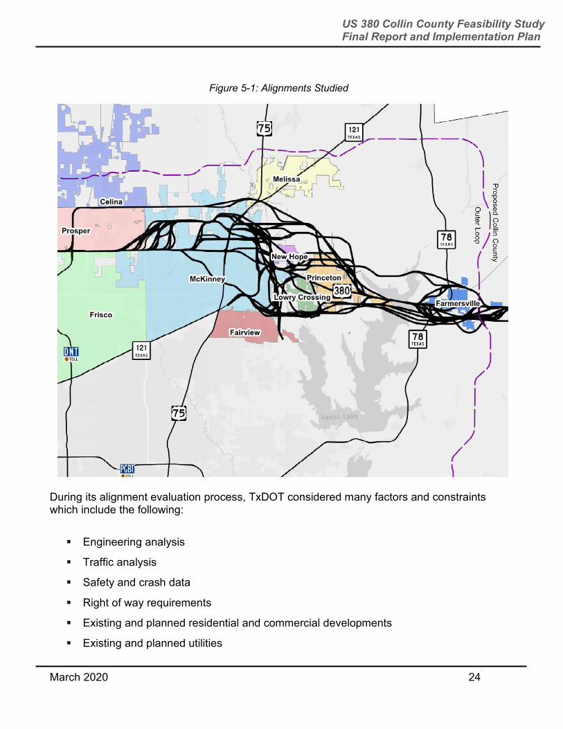
5.1 INITIAL ALIGNMENTS TxDOT began evaluating various alignment options in June 2017. Figure 5-1 shows all alignments evaluated during the study.
Figure 4-5: Roadway Options Comparison
March 2020 24
US 380 Collin County Feasibility Study Final Report and Implementation Plan
During its alignment evaluation process, TxDOT considered many factors and constraints which include the following:
Engineering analysis
Traffic analysis
Safety and crash data
Right of way requirements
Existing and planned residential and commercial developments
Existing and planned utilities
Figure 5-1: Alignments Studied
March 2020 25
US 380 Collin County Feasibility Study Final Report and Implementation Plan
Cost and economic impact
Other planning efforts
Natural and cultural resources
Endangered species
Land use and parkland
Water resources and flood plains
Hazardous materials
Social and community impacts
Stakeholder and public input
Alignments were eliminated from consideration if they did not address the problems identified in Section 3.0 or if they were deemed too negatively impactful.
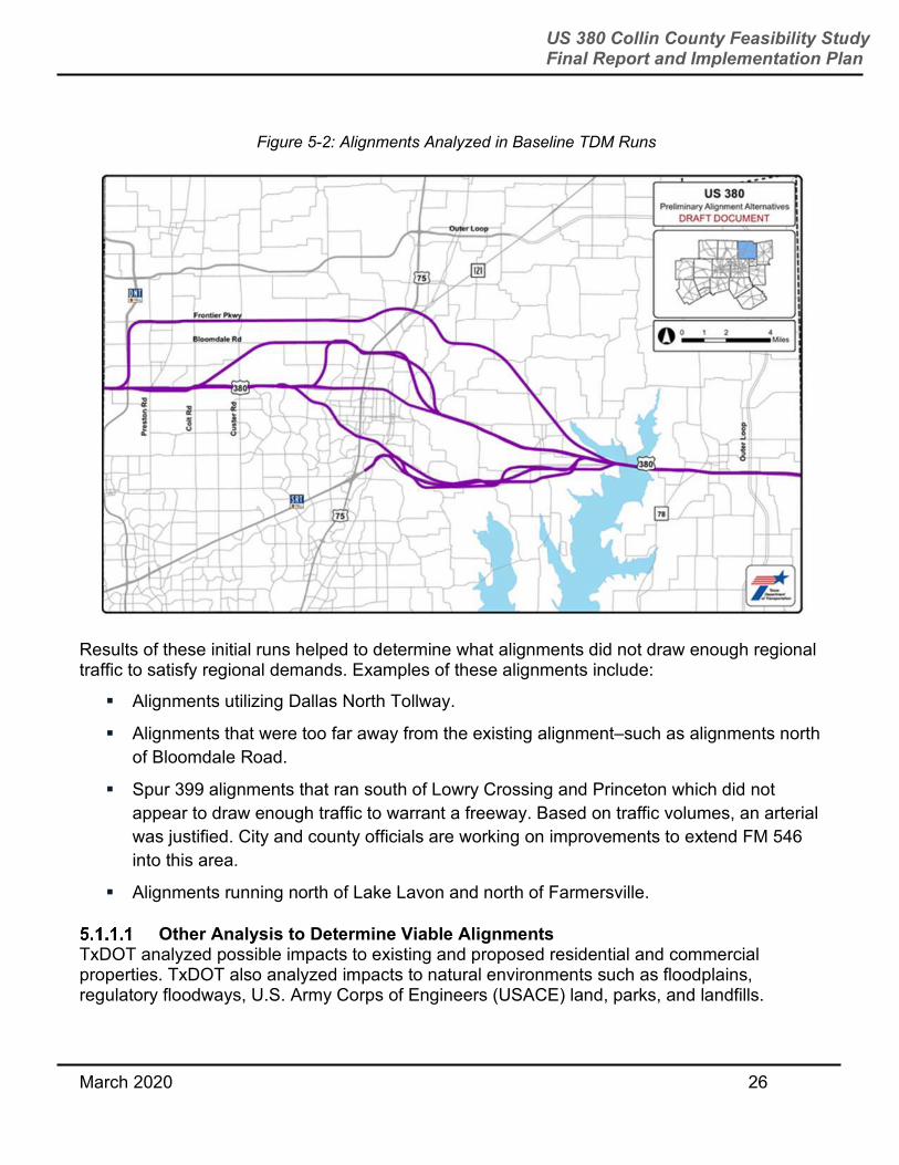
Traffic Analysis to Determine Viable Alignments Over the summer of 2017, the alignments shown in Figure 5-2 were analyzed through bracketed travel demand modeling runs. These bracketed initial runs were set up to serve as a baseline for the study, meaning that it included alignments that were along the existing US 380 and alignments that were several miles north and south of the existing US 380.
March 2020 26
US 380 Collin County Feasibility Study Final Report and Implementation Plan
Results of these initial runs helped to determine what alignments did not draw enough regional traffic to satisfy regional demands. Examples of these alignments include:
Alignments utilizing Dallas North Tollway.
Alignments that were too far away from the existing alignment–such as alignments north
of Bloomdale Road.
Spur 399 alignments that ran south of Lowry Crossing and Princeton which did not
appear to draw enough traffic to warrant a freeway. Based on traffic volumes, an arterial
was justified. City and county officials are working on improvements to extend FM 546
into this area.
Alignments running north of Lake Lavon and north of Farmersville.
Other Analysis to Determine Viable Alignments TxDOT analyzed possible impacts to existing and proposed residential and commercial properties. TxDOT also analyzed impacts to natural environments such as floodplains, regulatory floodways, U.S. Army Corps of Engineers (USACE) land, parks, and landfills.
Figure 5-2: Alignments Analyzed in Baseline TDM Runs
March 2020 27
US 380 Collin County Feasibility Study Final Report and Implementation Plan
For example, one of the alignments in Figures 5-1 and 5-2 significantly impacted existing parkland along Wilson Creek as well as the FEMA regulatory floodway channel west of US 75 and therefore was eliminated.
Other constraints considered were, but not limited to, historical and archeological sites, cemeteries, utilities, planned future developments, and schools, identified through desktop research or site visits. Section 5.3.1 details how TxDOT evaluated impacts.
When evaluating initial alignments shown in Figures 5-1 and 5-2, TxDOT determined that alignments that ran south of the existing alignment from west McKinney to the east were too impactful to homes and the Wilson Creek parkland. USACE property impacts eliminated alignments located near Lake Lavon on the east side of Princeton. Alignments that would impact USACE property were eliminated after a series of meetings with USACE Lavon Lake representatives revealed that the 2016 Lavon Lake Master Plan regulated specific land uses. Land in question was set aside for uses such as high and low-density recreation, wildlife management, and vegetative management. Any alignment north of Farmersville would impact more homes and businesses than bypassing the city to the south.
TxDOT presented the initial analysis at a technical work session of municipal, county and agency staff on September 7, 2017. Participants at that meeting asked TxDOT to consider the following:
Southern bypass around Farmersville including a new Lake Lavon crossing south of the
existing US 380.
Spur 399 extension option that ties back to US 380 west of the McKinney National
Airport at Airport Road.
Northern bypass that crosses US 75 near Laud Howell Parkway as well as looking at
other alignments previously proposed by the City of McKinney.
More study of possible alignments in and between the areas of east Prosper and West
McKinney.
5.2 VIABLE ALIGNMENTS – PRESENTED SPRING 2018
From the alignments initially considered, five viable alignments and a no-build alternative were presented at the first round of public meetings in the Spring of 2018. The five build alternatives were designed for a 70-mph design speed and 400 foot right of way (ROW) width. Below is a description of the alignments. Green and pink freeway alignments would widen the existing US 380. The green alignment proposed a widening to the north and the pink alignment widened to the south. Both included an extension of the existing Spur 399 on the west side of the McKinney National Airport.
The red, blue, and yellow alignments were all new location alignments that would primarily bypass McKinney and Princeton to the north and Farmersville to the south. While each alignment had segments that were unique to the alignment, many shared the same segments.
March 2020 28
US 380 Collin County Feasibility Study Final Report and Implementation Plan
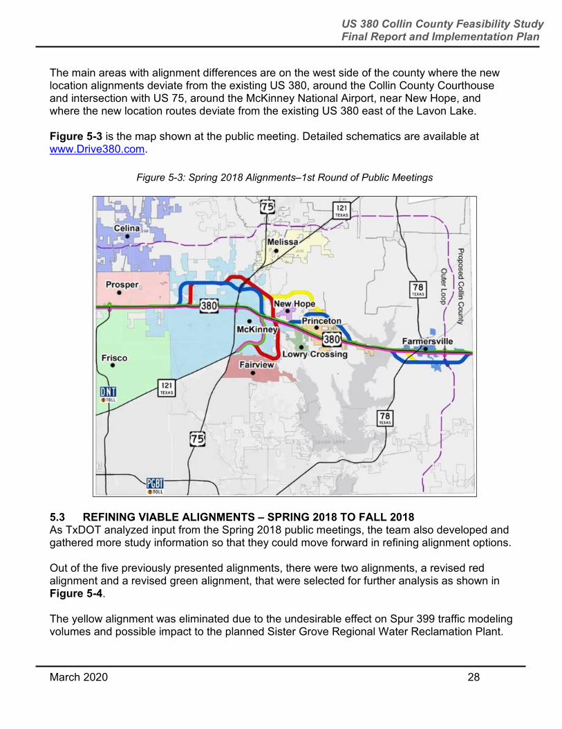
The main areas with alignment differences are on the west side of the county where the new location alignments deviate from the existing US 380, around the Collin County Courthouse and intersection with US 75, around the McKinney National Airport, near New Hope, and where the new location routes deviate from the existing US 380 east of the Lavon Lake. Figure 5-3 is the map shown at the public meeting. Detailed schematics are available at www.Drive380.com.
5.3 REFINING VIABLE ALIGNMENTS – SPRING 2018 TO FALL 2018 As TxDOT analyzed input from the Spring 2018 public meetings, the team also developed and gathered more study information so that they could move forward in refining alignment options.
Out of the five previously presented alignments, there were two alignments, a revised red alignment and a revised green alignment, that were selected for further analysis as shown in Figure 5-4.
The yellow alignment was eliminated due to the undesirable effect on Spur 399 traffic modeling volumes and possible impact to the planned Sister Grove Regional Water Reclamation Plant.
Figure 5-3: Spring 2018 Alignments–1st Round of Public Meetings

March 2020 29
US 380 Collin County Feasibility Study Final Report and Implementation Plan
The blue alignment was eliminated due to the number of impacts it created including impacts to an existing soil conservation lake, residential neighborhoods, USACE property, and a planned cemetery.
The revised green alignment was assembled using a combination of the pink and green alignments that best minimized impacts to business and residential properties.
The study team reviewed and reduced right of way for all alignments to an average between 330-350 feet wide. Exceptions to this would be around major interchanges where more ROW is needed for ramps, and limited areas where no ramps are needed, and less ROW can be utilized.
For the revised green alignment, option A placed the Spur 399 extension on the east side of McKinney National Airport and option B placed the Spur 399 extension on the west side of the airport.
The revised red alignment retained its original north-south segment that connected the bypass segment along Bloomdale Road to the current US 380 alignment just east of Stonebridge Drive. This came to be known as red option A. Due in part to public comments received, the former blue alignment segment that connected the bypass segment along Bloomdale Road to US 380 was shifted further west in order to achieve over 1,000 feet of separation between the Custer Road/First Street intersection and the proposed crossing of Custer Road. This came to be known as red option B.
In order to better understand impacts, the study area was also divided into the following five segments:
Denton County Line to Coit Road
Coit Road to FM 1827
Figure 5-4: Fall 2018 Alignments–2nd Round of Public Meetings
March 2020 30
US 380 Collin County Feasibility Study Final Report and Implementation Plan
FM 1827 to CR 559
CR 559 to Hunt County Line
Spur 399 from SH 121 to US 380
Evaluation Categories TxDOT developed the evaluation categories and applied those categories to each section. Below is more information on each of the categories used during TxDOT’s evaluation.
Figure 5-5 and Figure 5-6 shows examples of the differences in types of property impacts and displacements for business and residential properties.
Figure 5-5: Business Property Impact vs. Induced Displacement vs. Direct Displacement

March 2020 31
US 380 Collin County Feasibility Study Final Report and Implementation Plan
Below is a description of types of each of the evaluation criteria:
Residential property impacts – encroachment on a residential property.
Residential displacements – occurs when proposed ROW physically impacts a structure
or proximity would not meet distance requirements of new building codes.
Business impacts – encroachment on a business property.
Business induced displacements – occurs when proposed ROW would not require the
demolition of the building but would functionally impair business or proximity would not
meet fire codes or new building codes. Businesses were classified as an induced
displacement when the alignment prevented the business from being able to continue
operation. This could be due to the amount of land acquired, reduced parking
availability, or blocked access.
Business direct displacements – occurs when proposed ROW physically impacts a
structure.
Figure 5-6: Residential Property Impacts vs. Displacements
March 2020 32
US 380 Collin County Feasibility Study Final Report and Implementation Plan
Business displacements – sum of induced and direct business displacements for the
total business displacements.
Planned future development impacts – impending future commercial and future
residential development as provided by local governments and agencies.
Environmental, watershed and parkland impacts – environmental features were
researched and mapped at a desktop level. Evaluation also conducted limited
windshield surveys to verify mapped data. This included land uses, potential historic
properties, streams/other bodies of water, natural habitats, public facilities, cemeteries,
and hazardous material sites. Watershed evaluation consisted of a mapped FEMA 100-
year floodplain and regulatory floodway, and water impoundments. TxDOT researched
and mapped current and planned park areas based on available online data and review
of community’s park and development plans. TxDOT also consulted with city staff and
officials with jurisdiction regarding ownership, public access, and use of existing and
planned park properties. Sources of funding used for acquisition and development were
reviewed and properties were assessed to see if they met the formal definition of a
public park or recreational area under Section 4(f) of the DOT Act of 1966.
Cost of each alignment and alignment segment which included:
– Roadway construction cost
– Right of way cost
– Market cost of displaced structures
– Market cost of land
– Relocation assistance
– Cost to cure
– Relocation for impacted utilities
– Engineering cost
– Contingencies
Enhances regional mobility – determined through Traffic Data Model (TDM) and traffic
analysis.
Satisfies travel demand – determined through TDM and traffic analysis.
Supports future regional economic growth – determined by the economic analysis as
described in Section 8.0. This analysis found that economic impacts associated with the
green alignment are higher than impacts associated with the red alignment, both
cumulatively and at the jurisdiction level.
Traffic Analysis to Refine Viable Alignments Both the red and green alignments were modeled as freeways with three-lane mainlanes in each direction and two-lane frontage roads. On-ramps and off-ramps were included to and

March 2020 33
US 380 Collin County Feasibility Study Final Report and Implementation Plan
from major street intersections and direct connectors were included for major freeway to freeway interchanges including Dallas North Tollway, US 75, and Spur 399. Within each alignment, there were different configurations that were modeled. TDM and a high-level traffic impact of the proposed changes on US 380, Collin County, and the North Central Texas region were evaluated to compare the viable alignments.
Midway through the feasibility study, NCTCOG updated their TDM model from a projection year of 2040 to the year 2045. Because of this, the study team performed updated model runs using the NCTCOG 2045 MTP for the alignments under consideration. The model network for each alternative was revised to reflect the alignment being studied. This distinct model coding of each alignment was used in the alternative analysis. Each model alternative was run separately to compare traffic performance measures. Evaluating multiple alignments using the 2045 TDM ensured that the US 380 study is an effective project, both locally and regionally. They were performed at four different levels, ranging from the entire region to how each segment of US 380 performed. The first level evaluated the alignments at the regional level and the impact of the different alignments on the region. The second assessed Collin County and how the different alignments perform within Collin County. Next was analyzing US 380 only, and how the different alignments compared against each other in terms of performance. Lastly, the corridor was divided into the five different sections noted in Section 5.3 and analyzed on its performance compared to the other alignments.
US 380 Regionwide Traffic Analysis Results The existing alignment and other alignments studied were coded in distinct models as described below:
Metropolitan Transportation Plan (MTP) is a federally mandated document that serves
to identify transportation needs and guides transportation expenditures. NCTCOG’s
Regional Travel Demand Model, Mobility 2045, is compliant with the MTP and shows
US 380 as an arterial.
The green A alignment along existing US 380 has the Spur 399 extension to the east of
the McKinney Airport.
The green B alignment along existing US 380 has the Spur 399 extension to the west of
the McKinney Airport.
The red alignment primarily bypasses McKinney and Princeton to the north and
Farmersville to the south. The US 380 red A alignment has the north-south connection
from Bloomdale Road to the current US 380 alignment east of Stonebridge Drive.
The red alignment primarily bypasses McKinney and Princeton to the north and
Farmersville to the south. The red B alignment has the north-south connection from
Bloomdale Road shifted further west to achieve over 1,000 feet of separation between
the Custer Road/First Street intersection and the proposed crossing of Custer Road.

March 2020 34
US 380 Collin County Feasibility Study Final Report and Implementation Plan
At a regional level, there is no substantial difference in the traffic operational performance of green A and green B or red A and red B. However, the red alignment performs better than the green alignment. Both the red and green alignments perform better than the MTP. The regional level includes all 12 counties that are in the NCTCOG model. As a result, some of the benefits of the different alignments get diluted. The results are based on the following daily performance measures:
Vehicle Miles of Travel
Vehicle Hours of Travel
Vehicle Hours of Congestion Delay
Vehicle Hours of Traffic Control Delay of Used Roadway
Total Delay (Congestion + Traffic Control)
Total Delay in Road User Cost
These performance measures are defined under Section 4.2.
Figures 5-7 through 5-11 summarize performance measures for the different alignments.
Figure 5-7: US 380 Alignments Regionwide Traffic Performance Vehicle Miles of Travel
MTP Green A Green B Red A Red B
Vehicle Miles of Travel – All Roadways
331,496,000 330,944,000 330,938,000 330,955,000 330,935,000
Freeway 163,928,000 166,295,000 166,321,000 166,342,000 166,236,000
Others (Arterials, Collectors, and Frontage Road)
167,568,000 164,649,000 164,617,000 164,613,000 164,699,000

March 2020 35
US 380 Collin County Feasibility Study Final Report and Implementation Plan
Figure 5-8: US 380 Alignments Regionwide Traffic Performance Vehicle Hours of Travel
MTP Green A Green B Red A Red B
Vehicle Hours of Travel – All Roadways
10,174,000 10,088,000 10,089,000 10,074,000 10,074,000
Freeway 4,007,000 4,042,000 4,042,000 4,029,000 4,028,000
Others (Arterials, Collectors, and Frontage Road)
6,167,000 6,046,000 6,047,000 6,045,000 6,046,000
Figure 5-9: US 380 Alignments Regionwide Traffic Performance Vehicle Hours of Congestion Delay
MTP Green A Green B Red A Red B
Vehicle Hours of Congestion Delay - All Roadways
2,840,400 2,782,600 2,781,700 2,771,200 2,771,400
Freeway 1,467,500 1,456,700 1,455,700 1,447,800 1,448,100

March 2020 36
US 380 Collin County Feasibility Study Final Report and Implementation Plan
MTP Green A Green B Red A Red B
Others (Arterials, Collectors, and Frontage Road)
1,372,900 1,325,900 1,326,000 1,323,400 1,323,300
Figure 5-10: US 380 Alignments Regionwide Traffic Performance Vehicle Hours of Traffic Control Delay
MTP Green A Green B Red A Red B
Vehicle Hours of Traffic Control Delay of Used Roadway
947,700 934,500 935,400 937,200 937,600
Freeway 21,600 21,700 22,000 23,100 23,200
Others (Arterials, Collectors, and Frontage Road)
926,100 912,800 913,400 914,100 914,400
Total Delay (Congestion + Traffic Control)
3,788,100 3,717,100 3,717,100 3,708,400 3,709,000
March 2020 37
US 380 Collin County Feasibility Study Final Report and Implementation Plan
Figure 5-11: US 380 Alignments Regionwide Traffic Performance Total Delay in Road User Cost
MTP Green A Green B Red A Red B
Total Delay in Road User Cost - All Roadways
$84,853,440 $83,263,040 $83,263,040 $83,068,160 $83,081,600
Freeway $32,872,000 $32,630,080 $32,607,680 $32,430,720 $32,437,440
Others (Arterials, Collectors, and Frontage Road)
$30,752,960 $29,700,160 $29,702,400 $29,644,160 $29,641,920
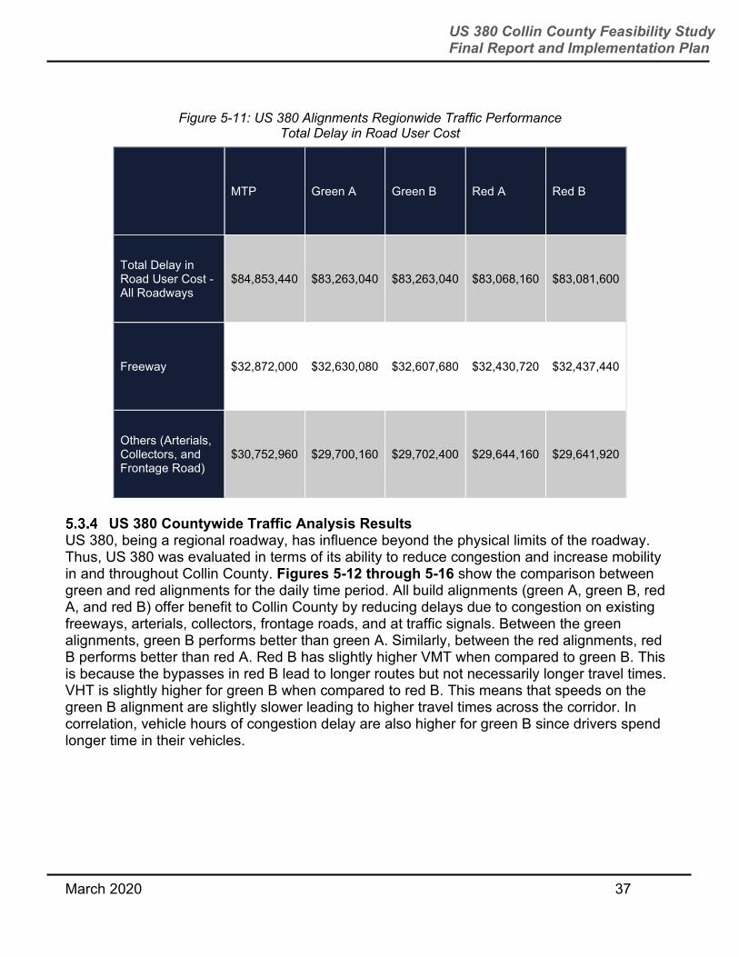
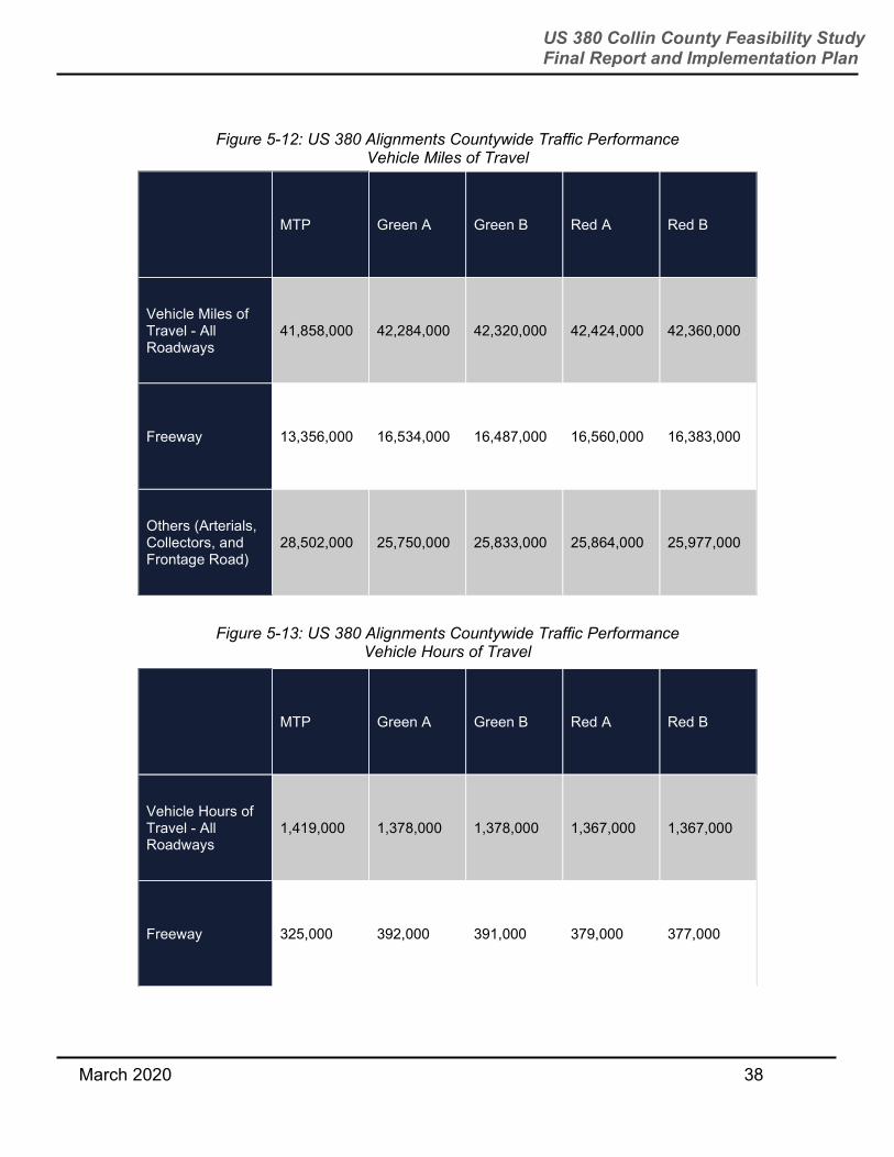
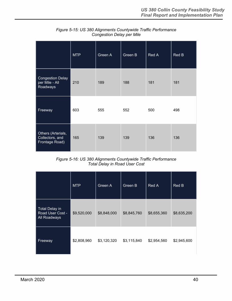
US 380 Countywide Traffic Analysis Results
US 380, being a regional roadway, has influence beyond the physical limits of the roadway. Thus, US 380 was evaluated in terms of its ability to reduce congestion and increase mobility in and throughout Collin County. Figures 5-12 through 5-16 show the comparison between green and red alignments for the daily time period. All build alignments (green A, green B, red A, and red B) offer benefit to Collin County by reducing delays due to congestion on existing freeways, arterials, collectors, frontage roads, and at traffic signals. Between the green alignments, green B performs better than green A. Similarly, between the red alignments, red B performs better than red A. Red B has slightly higher VMT when compared to green B. This is because the bypasses in red B lead to longer routes but not necessarily longer travel times. VHT is slightly higher for green B when compared to red B. This means that speeds on the green B alignment are slightly slower leading to higher travel times across the corridor. In correlation, vehicle hours of congestion delay are also higher for green B since drivers spend longer time in their vehicles.
March 2020 38
US 380 Collin County Feasibility Study Final Report and Implementation Plan
Figure 5-12: US 380 Alignments Countywide Traffic Performance Vehicle Miles of Travel
MTP Green A Green B Red A Red B
Vehicle Miles of Travel - All Roadways
41,858,000 42,284,000 42,320,000 42,424,000 42,360,000
Freeway 13,356,000 16,534,000 16,487,000 16,560,000 16,383,000
Others (Arterials, Collectors, and Frontage Road)
28,502,000 25,750,000 25,833,000 25,864,000 25,977,000
Figure 5-13: US 380 Alignments Countywide Traffic Performance Vehicle Hours of Travel
MTP Green A Green B Red A Red B
Vehicle Hours of Travel - All Roadways
1,419,000 1,378,000 1,378,000 1,367,000 1,367,000
Freeway 325,000 392,000 391,000 379,000 377,000

March 2020 39
US 380 Collin County Feasibility Study Final Report and Implementation Plan
MTP Green A Green B Red A Red B
Others (Arterials, Collectors, and Frontage Road)
1,094,000 986,000 987,000 988,000 990,000
Figure 5-14: US 380 Alignments Countywide Traffic Performance Vehicle Hours of Congestion Delay
MTP Green A Green B Red A Red B
Vehicle Hours of Congestion Delay - All Roadways
425,000 395,000 394,900 386,400 385,500
Freeway 125,400 139,300 139,100 131,900 131,500
Others (Arterials, Collectors, and Frontage Road)
299,600 255,700 255,800 254,500 254,000
March 2020 40
US 380 Collin County Feasibility Study Final Report and Implementation Plan
Figure 5-15: US 380 Alignments Countywide Traffic Performance Congestion Delay per Mile
MTP Green A Green B Red A Red B
Congestion Delay per Mile - All Roadways
210 189 188 181 181
Freeway 603 555 552 500 498
Others (Arterials, Collectors, and Frontage Road)
165 139 139 136 136
Figure 5-16: US 380 Alignments Countywide Traffic Performance
Total Delay in Road User Cost
MTP Green A Green B Red A Red B
Total Delay in Road User Cost - All Roadways
$9,520,000 $8,848,000 $8,845,760 $8,655,360 $8,635,200
Freeway $2,808,960 $3,120,320 $3,115,840 $2,954,560 $2,945,600

March 2020 41
US 380 Collin County Feasibility Study Final Report and Implementation Plan
MTP Green A Green B Red A Red B
Others (Arterials, Collectors, and Frontage Road)
$6,711,040 $5,727,680 $5,729,920 $5,700,800 $5,689,600
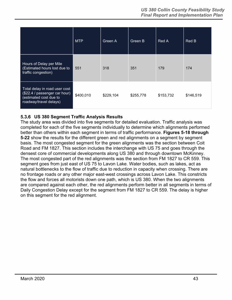
US 380 Corridor Only Traffic Analysis Results US 380 was also analyzed independent of other roadways in Collin County. These corridor-specific results were analyzed to identify the US 380 alignment that functions better than other alignments. The red alignments have almost 50 percent lower hours of delay per mile versus the green alignments. Average travel speed and peak period travel speeds for the red alignment are faster as well. Vehicle miles traveled on the red alignment are higher than the green alignment. This is due to the bypasses in the red alignment. Motorists would be driving a longer distance to get to the same destination using the red alignment. However, they would be reaching their destinations faster since the red alignment has less congestion than the green alignment. Figure 5-17 below shows the performance measures for US 380 by alignment.
Figure 5-17: US 380 Corridor Only Alignment Traffic Comparison
MTP Green A Green B Red A Red B
Average Daily Volume (Volume of daily vehicular traffic of a road)
46,200 86,300 90,200 76,666 74,695
AM Average Volume (Morning peak period traffic volume)
7,623 15,316 15,808 14,597 14,218

March 2020 42
US 380 Collin County Feasibility Study Final Report and Implementation Plan
MTP Green A Green B Red A Red B
PM Average Volume (PM peak period traffic volume)
10,509 21,326 22,041 19,436 19,065
US 380 Daily Vehicle Miles Traveled (Total number of miles traveled on the US 380 corridor)
1,487,262 2,804,367 2,929,464 3,041,565 2,916,824
Average V/C Ratio (Measure comparing vehicle volumes to roadway capacity)
1.03 0.65 0.65 0.56 0.54
Level of Service (Quality of the road being used)
F B B B B
Average Travel Speed (Average vehicular speed within the system limits)
40 54 54 65 65
Average Travel Speed Range (Range of average vehicular speeds within the system limits)
19 - 47 34 - 57 34 - 57 49 - 68 49 - 68
Peak Period Average Travel Speed (Average vehicular speed limit during high traffic times)
36 50 49 60 63
Daily Vehicle Hours Traveled (Total number of hours spent traveling)
54,598 53,513 60,306 50,117 48,028
March 2020 43
US 380 Collin County Feasibility Study Final Report and Implementation Plan
MTP Green A Green B Red A Red B
Hours of Delay per Mile (Estimated hours lost due to traffic congestion)
551 318 351 179 174
Total delay in road user cost ($22.4 / passenger car hour) (estimated cost due to roadway/travel delays)
$400,010 $229,104 $255,778 $153,732 $146,519
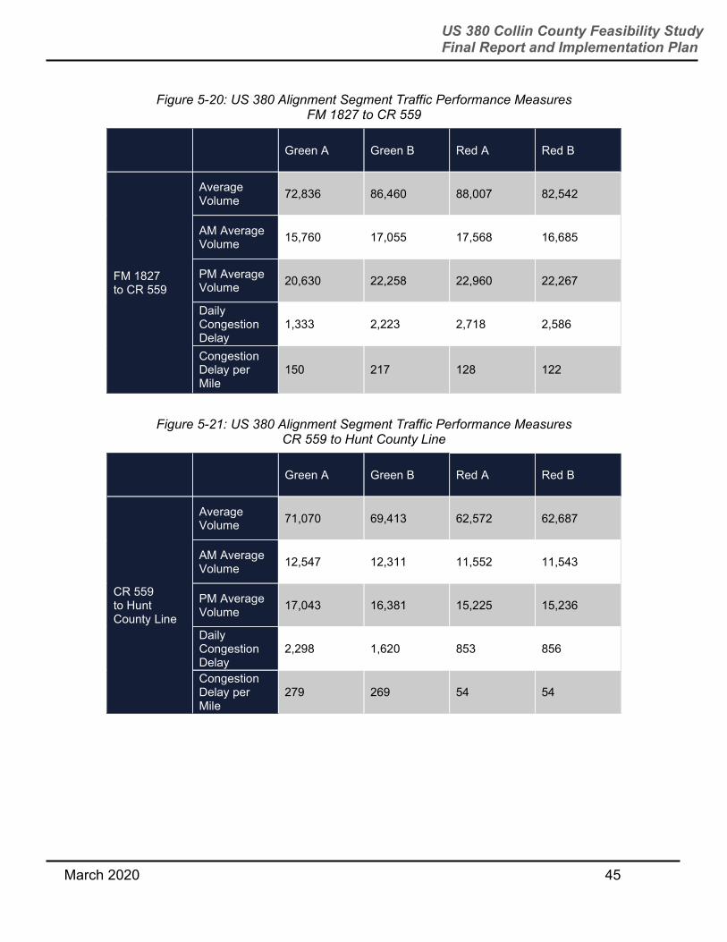
US 380 Segment Traffic Analysis Results
The study area was divided into five segments for detailed evaluation. Traffic analysis was completed for each of the five segments individually to determine which alignments performed better than others within each segment in terms of traffic performance. Figures 5-18 through 5-22 show the results for the different green and red alignments on a segment by segment basis. The most congested segment for the green alignments was the section between Coit Road and FM 1827. This section includes the interchange with US 75 and goes through the densest core of commercial developments along US 380 and through downtown McKinney. The most congested part of the red alignments was the section from FM 1827 to CR 559. This segment goes from just east of US 75 to Lavon Lake. Water bodies, such as lakes, act as natural bottlenecks to the flow of traffic due to reduction in capacity when crossing. There are no frontage roads or any other major east-west crossings across Lavon Lake. This constricts the flow and forces all motorists down one path, which is US 380. When the two alignments are compared against each other, the red alignments perform better in all segments in terms of Daily Congestion Delay except for the segment from FM 1827 to CR 559. The delay is higher on this segment for the red alignment.

March 2020 44
US 380 Collin County Feasibility Study Final Report and Implementation Plan
Figure 5-18: US 380 Alignment Segment Traffic Performance Measures Denton County Line to Coit Road
Green A Green B Red A Red B
Denton County Line to Coit Road
Average Volume
81,526 80,847 96,026 96,389
AM Average Volume
14,107 14,086 16,603 16,717
PM Average Volume
19,869 19,781 23,494 23,627
Daily Congestion Delay
1,075 1,040 880 918
Congestion Delay per Mile
242 234 99 103
Figure 5-19: US 380 Alignment Segment Traffic Performance Measures Coit Road to FM 1827
Green A Green B Red A Red B
Coit Road to FM 1827
Average Volume
99,260 105,414 69,998 67,133
AM Average Volume
17,092 17,898 14,055 13,447
PM Average Volume
24,312 25,705 18,280 17,579
Daily Congestion Delay
6,432 6,664 2,405 2,186
Congestion Delay per Mile
546 566 78 75
March 2020 45
US 380 Collin County Feasibility Study Final Report and Implementation Plan
Figure 5-20: US 380 Alignment Segment Traffic Performance Measures FM 1827 to CR 559
Green A Green B Red A Red B
FM 1827 to CR 559
Average Volume
72,836 86,460 88,007 82,542
AM Average Volume
15,760 17,055 17,568 16,685
PM Average Volume
20,630 22,258 22,960 22,267
Daily Congestion Delay
1,333 2,223 2,718 2,586
Congestion Delay per Mile
150 217 128 122
Figure 5-21: US 380 Alignment Segment Traffic Performance Measures CR 559 to Hunt County Line
Green A Green B Red A Red B
CR 559 to Hunt County Line
Average Volume
71,070 69,413 62,572 62,687
AM Average Volume
12,547 12,311 11,552 11,543
PM Average Volume
17,043 16,381 15,225 15,236
Daily Congestion Delay
2,298 1,620 853 856
Congestion Delay per Mile
279 269 54 54

March 2020 46
US 380 Collin County Feasibility Study Final Report and Implementation Plan
Figure 5-22: US 380 Alignment Segment Traffic Performance Measures SPUR 399 Extension
Green A Green B Red A Red B
SPUR 399 Extension
Average Volume
45,273 67,445 42,448 37,833
AM Average Volume
9,181 11,808 8,402 7,994
PM Average Volume
13,528 17,095 12,306 11,735
Daily Congestion Delay
728 1,208 596 581
Congestion Delay per Mile
136 321 55 54
5.4 DEVELOPING A RECOMMENDED ALIGNMENT – FALL 2018 TO SUMMER 2019 After the October 2018 public meetings, TxDOT continued to advance the feasibility study through the following tasks:
Continued to work with NCTCOG to conduct and modify additional traffic analyses and
travel demand modeling (performing a total of 20 different alignment runs).
Because of many concerns raised related to traffic noise, TxDOT conducted a
preliminary noise analysis in the study area. This is something that is traditionally done
in the environmental stages of project development, not in the feasibility phase. Results
of the study can be found in Section 6.4.
Because of concerns raised by municipalities and the public about how alignments
would impact local tax revenues, TxDOT analyzed short-term economic impacts to the
communities of Frisco, Prosper, McKinney, Princeton, and Farmersville. Results of the
study can be found in Section 8.0.
Considered public and stakeholder input received from the Fall 2018 public meetings.

March 2020 47
US 380 Collin County Feasibility Study Final Report and Implementation Plan
Each of these tasks informed decisions to create new alignment segments detailed in Section 5.4.2 and presented at MAPO meetings in the Spring of 2019. Figure 5-23 below shows the county line to county line TxDOT recommended alignment.
Traffic Analysis Summary
Throughout all the traffic analysis completed during the study, TxDOT found the following:
If nothing is done, US 380 will continue to experience a failing level of service in the
future, even if we built all the planned roadways in Collin County including the Outer
Loop that is being planned by Collin County. Therefore, a US 380 freeway is needed to
relieve congestion.
The benefit of a well-functioning US 380 extends beyond the paved limits of the
highway – it attracts traffic from local city streets thereby reducing congestion on those
streets and shortening the travel time it takes to get from one place to another within
and through Collin County.
While the green alignment attracts more traffic than the red alignments on US 380, the
red alignment, being a new location highway, still maintains the existing US 380
roadway in central Collin County. Therefore, evaluating how US 380 and local streets
work together as a system, the red alignments are more effective than the green
alignments in increasing mobility.
The study found that the red alignments will reduce more regionwide traffic congestion
than the green alignments. This is measured by hours of congestion relief as compared
to the no-build option. These hours represent the amount of time each freeway option
saved individuals from sitting in traffic.
Figure 5-23: Recommended Alignment
March 2020 48
US 380 Collin County Feasibility Study Final Report and Implementation Plan
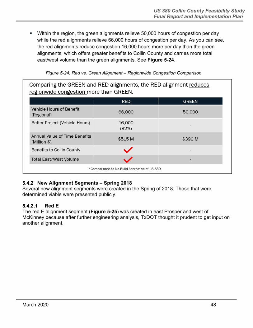
Within the region, the green alignments relieve 50,000 hours of congestion per day
while the red alignments relieve 66,000 hours of congestion per day. As you can see,
the red alignments reduce congestion 16,000 hours more per day than the green
alignments, which offers greater benefits to Collin County and carries more total
east/west volume than the green alignments. See Figure 5-24.
New Alignment Segments – Spring 2018 Several new alignment segments were created in the Spring of 2018. Those that were determined viable were presented publicly.
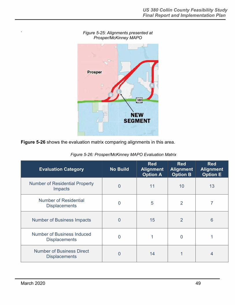
Red E The red E alignment segment (Figure 5-25) was created in east Prosper and west of McKinney because after further engineering analysis, TxDOT thought it prudent to get input on another alignment.
Figure 5-24: Red vs. Green Alignment – Regionwide Congestion Comparison
March 2020 49
US 380 Collin County Feasibility Study Final Report and Implementation Plan
.
Figure 5-26 shows the evaluation matrix comparing alignments in this area.
Evaluation Category No Build
Red Alignment Option A
Red Alignment Option B
Red Alignment Option E
Number of Residential Property Impacts
0 11 10 13
Number of Residential Displacements
0 5 2 7
Number of Business Impacts 0 15 2 6
Number of Business Induced Displacements
0 1 0 1
Number of Business Direct Displacements
0 14 1 4
Figure 5-26: Prosper/McKinney MAPO Evaluation Matrix
Figure 5-25: Alignments presented at Prosper/McKinney MAPO

March 2020 50
US 380 Collin County Feasibility Study Final Report and Implementation Plan
Evaluation Category No Build Red
Alignment Option A
Red Alignment Option B
Red Alignment Option E
Number of Business Displacements 0 15 1 5
Planned Future Development Impacts (acres)
0 11 89 51.7
Environmental, Watershed, and Park Land Impacts (acres)
0 30 16 8.5
Cost - includes construction, ROW, utility relocation
0 $331M $192M $253M
Enhances Regional Mobility
Satisfies Travel Demand
Enhances Safety
Supports Future Regional Economic Growth
Does not achieve criteria
Sometimes meets criteria
Partially meets criteria
Mostly meets criteria
Highly meets criteria
March 2020 51
US 380 Collin County Feasibility Study Final Report and Implementation Plan
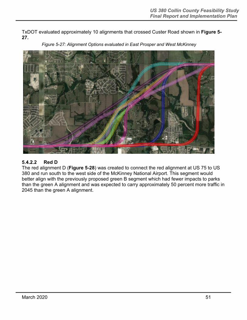
TxDOT evaluated approximately 10 alignments that crossed Custer Road shown in Figure 5-27.
Red D
The red alignment D (Figure 5-28) was created to connect the red alignment at US 75 to US 380 and run south to the west side of the McKinney National Airport. This segment would better align with the previously proposed green B segment which had fewer impacts to parks than the green A alignment and was expected to carry approximately 50 percent more traffic in 2045 than the green A alignment.
Figure 5-27: Alignment Options evaluated in East Prosper and West McKinney

March 2020 52
US 380 Collin County Feasibility Study Final Report and Implementation Plan
Figure 5-29 shows the evaluation matrix comparing the red C and D alignments and Figure 5-30 shows the red C/green A and red D/green B alignments in this area.
Evaluation Category No Build Red
Alignment Option C
Red Alignment Option D
Number of Residential Property Impacts
0 11 2
Number of Residential Displacements
0 8 6
Number of Business Impacts 0 1 2
Number of Business Induced Displacements
0 1 0
Number of Business Direct Displacements
0 0 1
Figure 5-29: Red C and D Alignment Evaluation Matrix
Figure 5-28: Alignments presented at Northeast McKinney MAPO

March 2020 53
US 380 Collin County Feasibility Study Final Report and Implementation Plan
Evaluation Category No Build Red
Alignment Option C
Red Alignment Option D
Number of Business Displacements 0 1 1
Planned Future Development Impacts (acres)
0 5 2.7
Environmental, Watershed, and Park Land Impacts (acres)
0 48 115
Cost - includes construction, ROW, utility relocation
0 $185M $294M
Enhances Regional Mobility
Satisfies Travel Demand
Enhances Safety
Supports Future Regional Economic Growth
Does not achieve criteria
Sometimes meets criteria
Partially meets criteria
Mostly meets criteria
Highly meets criteria

March 2020 54
US 380 Collin County Feasibility Study Final Report and Implementation Plan
Evaluation Category No Build
Red Alignment Option C +
Green Alignment Option A
Red Alignment Option D +
Green Alignment Option B
Number of Residential Property Impacts
0 25 7
Number of Residential Displacements 0 12 6
Number of Business Impacts 0 7 9
Number of Business Induced Displacements
0 1 0
Number of Business Direct Displacements
0 1 3
Number of Business Displacements 0 2 3
Planned Future Development Impacts (acres)
0 16.1 8.2
Environmental, Watershed, and Park Land Impacts (acres)
0 221 236
Cost - includes construction, ROW, utility relocation
0 $618M $560M
Enhances Regional Mobility
Satisfies Travel Demand
Figure 5-30: Red C/Green A and Red D/Green B Evaluation Matrix

March 2020 55
US 380 Collin County Feasibility Study Final Report and Implementation Plan
Evaluation Category No Build
Red Alignment Option C +
Green Alignment Option A
Red Alignment Option D +
Green Alignment Option B
Enhances Safety
Supports Future Regional Economic Growth
Green Alignment North Shift – Hardin to US 75 A northern shift for the green alignment was considered based on input provided by Raytheon, one of McKinney’s largest employers. The green alignment, as it was proposed in October 2018, could have a significant impact on their current operations and their future expansion plans. Figure 5-31 shows the alignment shift that was considered.
Figure 5-31: North Shift Green Alignment – Hardin to US 75
Does not achieve criteria
Sometimes meets criteria
Partially meets criteria
Mostly meets criteria
Highly meets criteria

March 2020 56
US 380 Collin County Feasibility Study Final Report and Implementation Plan
TxDOT identified several major impacts that would likely result from this north shift from Hardin Boulevard to US 75. They included:
Displacing 30 more residences.
Displacing 37 more businesses including displacing and or impacting new
developments/businesses at all four corners of US 380 and Hardin.
Impacting a fire station.
Impacting Collin College property.
Segment Evaluations – Recommended Alignment Deciding Factors The sections below outline major deciding factors used by TxDOT to decide on the recommended alignment. These sections are broken down into the five segments of the study area.
Denton County Line to Coit Road The TxDOT recommended alignment from the Denton County line to Coit Road (see Figure 5-32) was the green alignment because of the minimal impacts and displacements that would likely occur.
Figure 5-32: Denton County Line to Coit Road
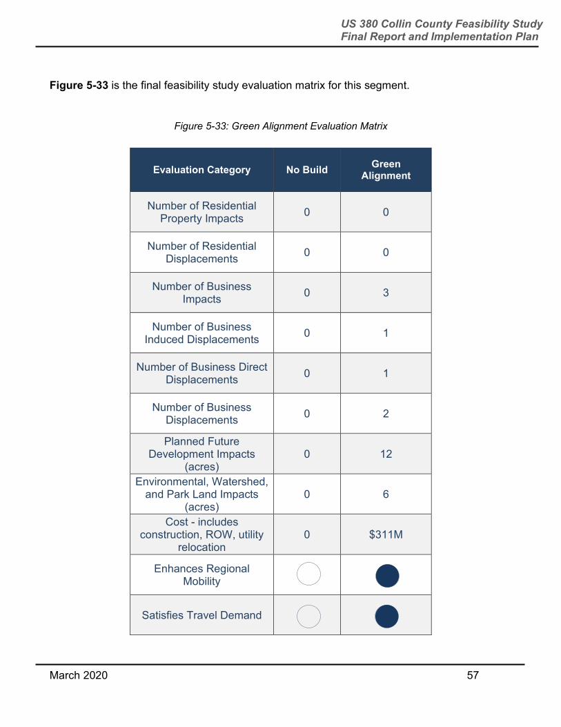
March 2020 57
US 380 Collin County Feasibility Study Final Report and Implementation Plan
Figure 5-33 is the final feasibility study evaluation matrix for this segment.
Figure 5-33: Green Alignment Evaluation Matrix
Evaluation Category No Build Green
Alignment
Number of Residential Property Impacts
0 0
Number of Residential Displacements
0 0
Number of Business Impacts
0 3
Number of Business Induced Displacements
0 1
Number of Business Direct Displacements
0 1
Number of Business Displacements
0 2
Planned Future Development Impacts
(acres) 0 12
Environmental, Watershed, and Park Land Impacts
(acres) 0 6
Cost - includes construction, ROW, utility
relocation 0 $311M
Enhances Regional Mobility
Satisfies Travel Demand

March 2020 58
US 380 Collin County Feasibility Study Final Report and Implementation Plan
Evaluation Category No Build Green
Alignment
Enhances Safety
Supports Future Regional Economic Growth
The following are key takeaways from the matrix:
No residential properties will be impacted or displaced. Three businesses would be
impacted and two would be displaced.
Potentially there would be impacts to 12 acres of land currently planned for future
development.
Figure 5-34 shows the average typical section for this segment. The right of way width would average around 330 feet. The exception to this would be around major interchanges, such as at DNT, where more land will be needed for ramps and direct connectors.
Figure 5-34: Denton County Line to Coit Road Typical Section
330’ RIGHT OF WAY
Does not achieve criteria
Sometimes meets criteria
Partially meets criteria
Mostly meets criteria
Highly meets criteria
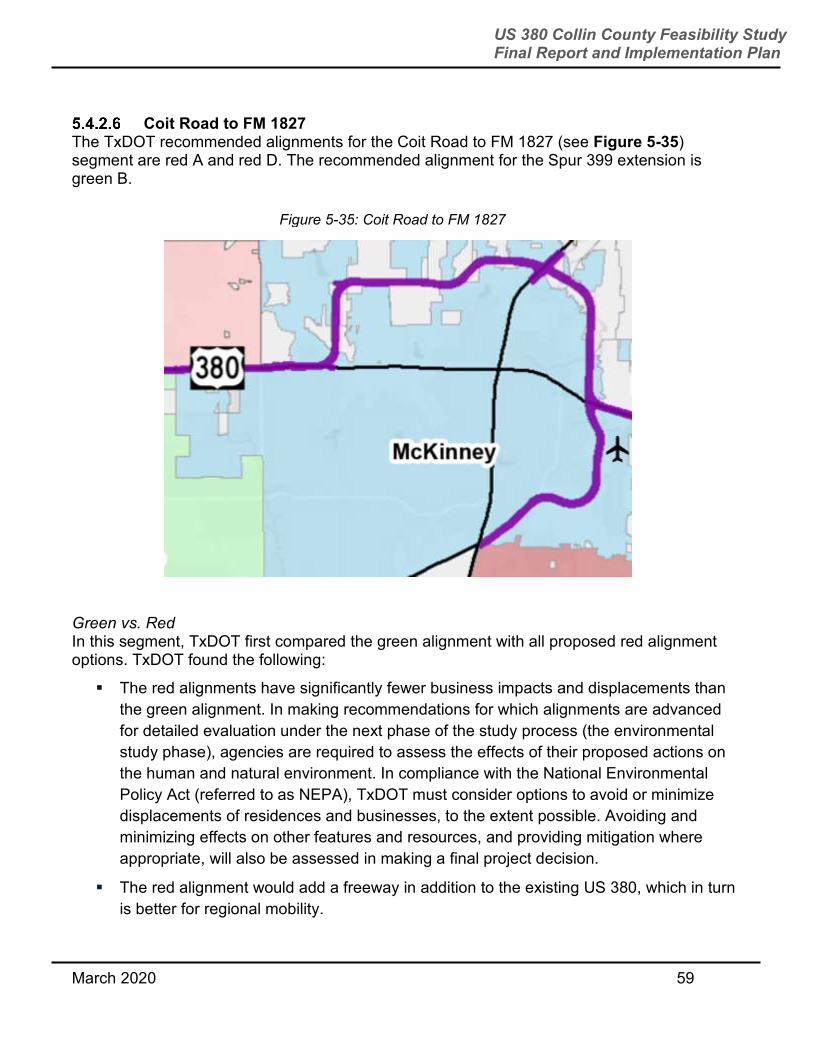
March 2020 59
US 380 Collin County Feasibility Study Final Report and Implementation Plan
Coit Road to FM 1827 The TxDOT recommended alignments for the Coit Road to FM 1827 (see Figure 5-35) segment are red A and red D. The recommended alignment for the Spur 399 extension is green B.
Green vs. Red
In this segment, TxDOT first compared the green alignment with all proposed red alignment options. TxDOT found the following:
The red alignments have significantly fewer business impacts and displacements than
the green alignment. In making recommendations for which alignments are advanced
for detailed evaluation under the next phase of the study process (the environmental
study phase), agencies are required to assess the effects of their proposed actions on
the human and natural environment. In compliance with the National Environmental
Policy Act (referred to as NEPA), TxDOT must consider options to avoid or minimize
displacements of residences and businesses, to the extent possible. Avoiding and
minimizing effects on other features and resources, and providing mitigation where
appropriate, will also be assessed in making a final project decision.
The red alignment would add a freeway in addition to the existing US 380, which in turn
is better for regional mobility.
Figure 5-35: Coit Road to FM 1827
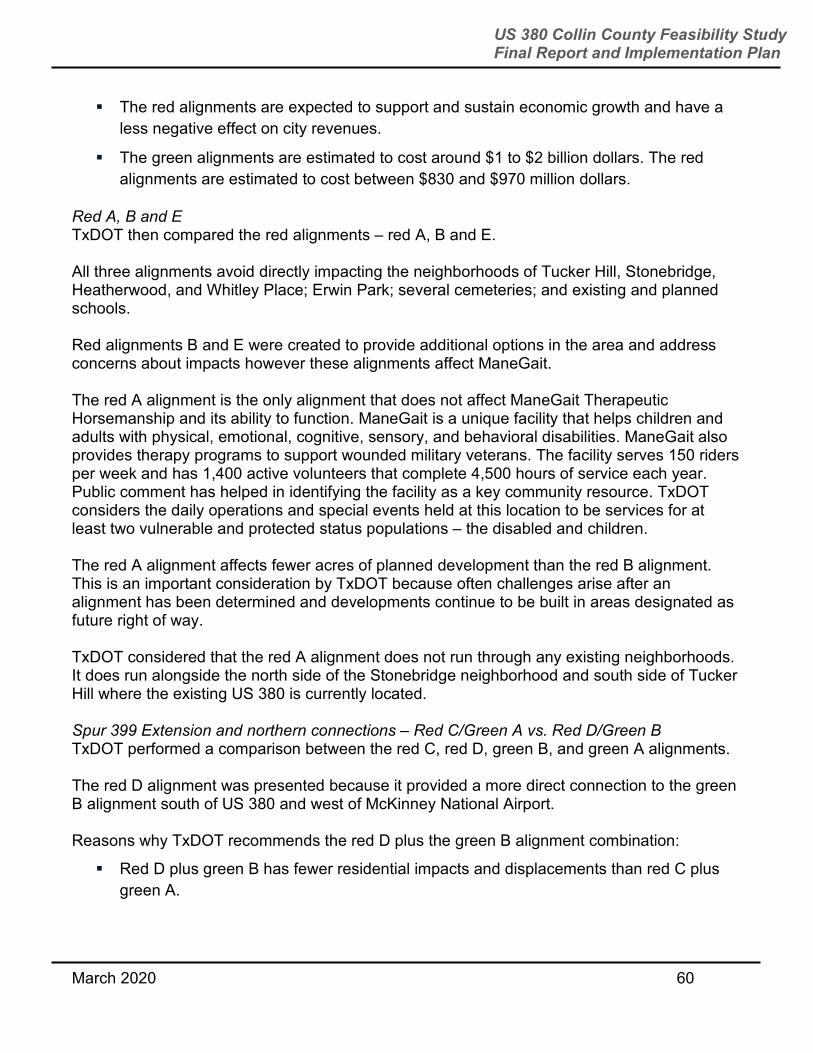
March 2020 60
US 380 Collin County Feasibility Study Final Report and Implementation Plan
The red alignments are expected to support and sustain economic growth and have a
less negative effect on city revenues.
The green alignments are estimated to cost around $1 to $2 billion dollars. The red
alignments are estimated to cost between $830 and $970 million dollars.
Red A, B and E
TxDOT then compared the red alignments – red A, B and E.
All three alignments avoid directly impacting the neighborhoods of Tucker Hill, Stonebridge, Heatherwood, and Whitley Place; Erwin Park; several cemeteries; and existing and planned schools.
Red alignments B and E were created to provide additional options in the area and address concerns about impacts however these alignments affect ManeGait.
The red A alignment is the only alignment that does not affect ManeGait Therapeutic Horsemanship and its ability to function. ManeGait is a unique facility that helps children and adults with physical, emotional, cognitive, sensory, and behavioral disabilities. ManeGait also provides therapy programs to support wounded military veterans. The facility serves 150 riders per week and has 1,400 active volunteers that complete 4,500 hours of service each year. Public comment has helped in identifying the facility as a key community resource. TxDOT considers the daily operations and special events held at this location to be services for at least two vulnerable and protected status populations – the disabled and children.
The red A alignment affects fewer acres of planned development than the red B alignment. This is an important consideration by TxDOT because often challenges arise after an alignment has been determined and developments continue to be built in areas designated as future right of way.
TxDOT considered that the red A alignment does not run through any existing neighborhoods. It does run alongside the north side of the Stonebridge neighborhood and south side of Tucker Hill where the existing US 380 is currently located.
Spur 399 Extension and northern connections – Red C/Green A vs. Red D/Green B
TxDOT performed a comparison between the red C, red D, green B, and green A alignments.
The red D alignment was presented because it provided a more direct connection to the green B alignment south of US 380 and west of McKinney National Airport.
Reasons why TxDOT recommends the red D plus the green B alignment combination:
Red D plus green B has fewer residential impacts and displacements than red C plus
green A.

March 2020 61
US 380 Collin County Feasibility Study Final Report and Implementation Plan
Green B encroaches on fewer park parcels than green A.
Green B carries more traffic than green A.
The combination of red D with green A or red C with green B was considered but would not provide a direct connection. The green A alignment would also impact Cornerstone Ranch which serves as a group home and provides day programs for specific populations including persons with disabilities. TxDOT was notified after the final series of public meetings that this facility intends to relocate in the future.
Figure 5-36 is the final feasibility study evaluation matrix for this segment.
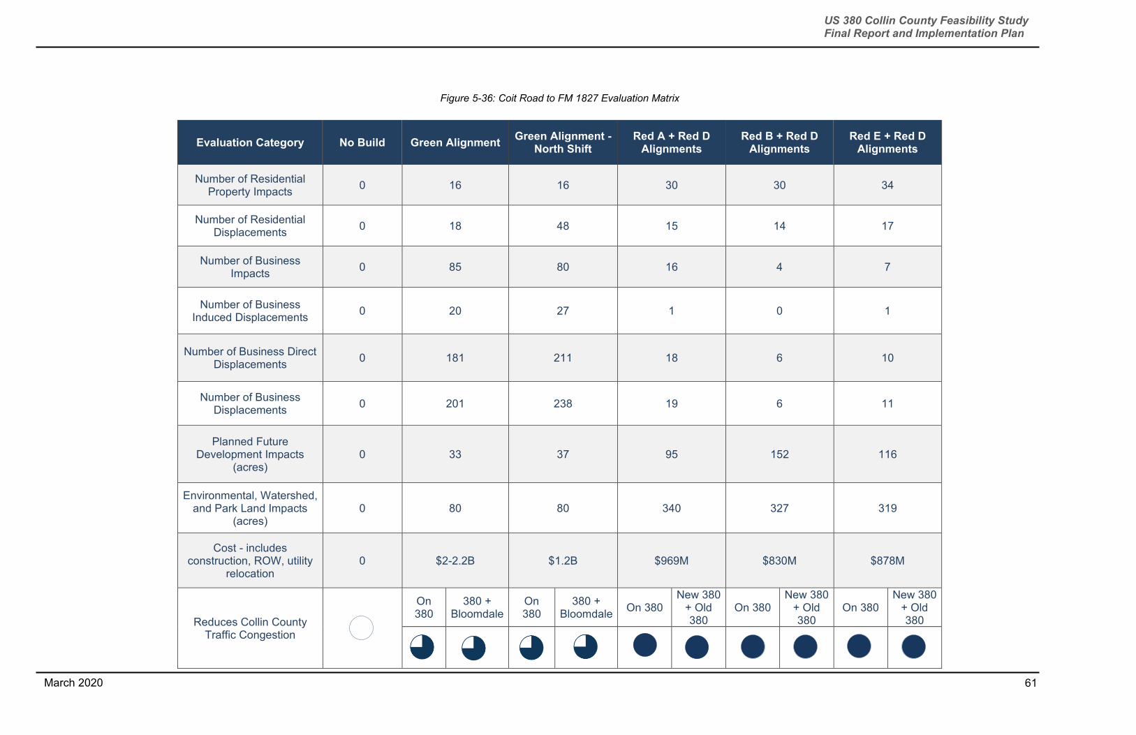
61
US 380 Collin County Feasibility Study Final Report and Implementation Plan
March 2020
Figure 5-36: Coit Road to FM 1827 Evaluation Matrix
Evaluation Category No Build Green Alignment Green Alignment -
North Shift Red A + Red D
Alignments Red B + Red D
Alignments Red E + Red D
Alignments
Number of Residential Property Impacts
0 16 16 30 30 34
Number of Residential Displacements
0 18 48 15 14 17
Number of Business Impacts
0 85 80 16 4 7
Number of Business Induced Displacements
0 20 27 1 0 1
Number of Business Direct Displacements
0 181 211 18 6 10
Number of Business Displacements
0 201 238 19 6 11
Planned Future Development Impacts
(acres) 0 33 37 95 152 116
Environmental, Watershed, and Park Land Impacts
(acres) 0 80 80 340 327 319
Cost - includes construction, ROW, utility
relocation 0 $2-2.2B $1.2B $969M $830M $878M
Reduces Collin County Traffic Congestion
On 380
380 + Bloomdale
On 380
380 + Bloomdale
On 380 New 380
+ Old 380
On 380 New 380
+ Old 380
On 380 New 380
+ Old 380
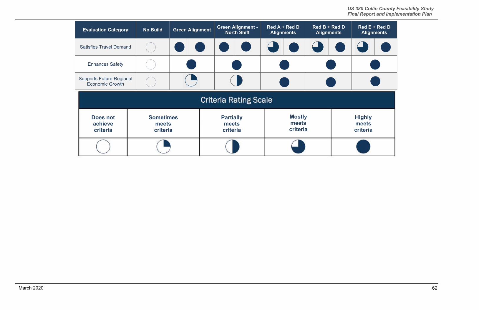
62
US 380 Collin County Feasibility Study Final Report and Implementation Plan
March 2020
Evaluation Category No Build Green Alignment Green Alignment -
North Shift Red A + Red D
Alignments
Red B + Red D Alignments
Red E + Red D Alignments
Satisfies Travel Demand
Enhances Safety
Supports Future Regional Economic Growth
Does not achieve criteria
Sometimes meets criteria
Partially meets criteria
Mostly meets criteria
Highly meets criteria
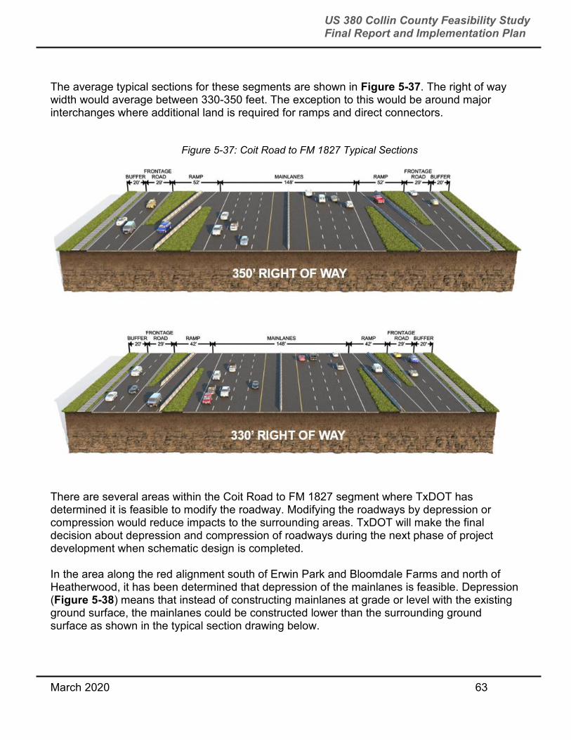
March 2020 63
US 380 Collin County Feasibility Study Final Report and Implementation Plan
The average typical sections for these segments are shown in Figure 5-37. The right of way width would average between 330-350 feet. The exception to this would be around major interchanges where additional land is required for ramps and direct connectors.
There are several areas within the Coit Road to FM 1827 segment where TxDOT has determined it is feasible to modify the roadway. Modifying the roadways by depression or compression would reduce impacts to the surrounding areas. TxDOT will make the final decision about depression and compression of roadways during the next phase of project development when schematic design is completed.
In the area along the red alignment south of Erwin Park and Bloomdale Farms and north of Heatherwood, it has been determined that depression of the mainlanes is feasible. Depression (Figure 5-38) means that instead of constructing mainlanes at grade or level with the existing ground surface, the mainlanes could be constructed lower than the surrounding ground surface as shown in the typical section drawing below.
Figure 5-37: Coit Road to FM 1827 Typical Sections

March 2020 64
US 380 Collin County Feasibility Study Final Report and Implementation Plan
In the area along the green alignment between Tucker Hill and Stonebridge, it has been determined that depression and compression of the roadway is feasible. Compression of a roadway means that instead of the 330-350 feet of right of way, that it is feasible to compress the right of way for this short segment to around 240 feet of right of way in order to reduce impacts to adjacent properties. At this right of way width, the segment would not have access ramps.
Modifying roadways with depressed and compressed sections is not feasible in all study areas. In areas where adjacent undeveloped or minimally developed property exists, it is more cost effective to maintain an at-grade typical section than a depressed and/or compressed typical section. Also depressed sections are not considered in areas that fall within a floodplain in order to ensure flooding does not occur during rainfall events. Compressed sections are also not considered for long segments because ramps must be provided to allow access to other roadways and neighborhoods. TxDOT reviewed existing ground profile data, flood event elevations and prepared a preliminary mainlane profile design to determine if a depressed while avoiding flooding issues.
Figure 5-38: Compressed and Depressed Typical Sections

March 2020 65
US 380 Collin County Feasibility Study Final Report and Implementation Plan
FM 1827 to CR559 The TxDOT recommended alignment for this segment was the red alignment (see Figure 5-39).
Deciding factors for this segment were business impacts and displacements, cost, and future economic growth. Most notably, if constructed today the green alignment would displace 122 businesses as compared to 19 displaced by the red alignment. The green alignment is expected to cost almost $100 million dollars more than the red alignment. Figure 5-40 is the evaluation matrix for this segment.
Figure 5-40: Green vs. Red Alignment Evaluation Matrix
Evaluation Category No Build Green
Alignment Red
Alignment
Number of Residential Property Impacts
0 10 12
Number of Residential Displacements
0 14 10
Number of Business Impacts
0 22 0
Figure 5-39: FM 1827 to CR 559 Alignment Segment

March 2020 66
US 380 Collin County Feasibility Study Final Report and Implementation Plan
Evaluation Category No Build Green
Alignment Red
Alignment
Number of Business Induced Displacements
0 6 0
Number of Business Direct Displacements
0 116 19
Number of Business Displacements
0 122 19
Planned Future Development Impacts
(acres) 0 42 105
Environmental, Watershed, and Park Land Impacts
(acres) 0 16 29
Cost - includes construction, ROW, utility
relocation 0 $452M $353M
Enhances Regional Mobility
Satisfies Travel Demand
Enhances Safety
Supports Future Regional Economic Growth
Does not achieve criteria
Sometimes meets criteria
Partially meets criteria
Mostly meets criteria
Highly meets criteria

March 2020 67
US 380 Collin County Feasibility Study Final Report and Implementation Plan
The average typical sections for these segments are identical to the ones in Figure 5-37. The right of way width would average between 330-350 feet. The exception to this would be around major interchanges where additional land is required for ramps and direct connectors.
CR 559 to Hunt County The TxDOT recommended alignment for this segment is the red alignment.
The major deciding factor for this segment were the fewer residential and business displacements associated with the red alignment. The green alignment would displace 39 residences as compared to three displaced by the red alignment. The green alignment would displace 27 businesses as compared to one displaced by the red alignment. The green alignment is expected to cost more than the red alignment.
The average typical sections for these segments are identical to the ones in Figure 5-37. The right of way width would average between 330-350 feet. The exception to this would be around major interchanges where additional land is required for ramps and direct connectors.
6.0 ENVIRONMENTAL OVERVIEW
6.1 LAND USE – EXISTING AND PLANNED, AIRPORT EXPANSION US 380 serves as a major east-west travel corridor across Collin County, connecting the communities of Prosper, Frisco, Celina, McKinney, Melissa, Fairview, New Hope, Lowry Crossing, Princeton, and Farmersville. A patchwork of urban, suburban, residential, industrial, commercial, and agricultural uses occupy the length of US 380 under study. A portion of the roadway under study crosses over Lavon Lake, managed by USACE. Businesses are largely concentrated in the incorporated cities along the highway corridor, with much of the area between communities still dominated by agricultural uses (pastureland and crops) especially between McKinney and Farmersville. Development has and continues to occur along the US 380 corridor, including both commercial/retail and residential areas. Many new developments as well as commercial redevelopment are being allowed to build up to the existing highway right of way, restricting the area for future expansion of the highway footprint. These primary areas include:
Coit Road to Custer Road (Prosper)
Stonebridge Drive to Lake Forest Drive (Prosper/McKinney)
Hardin Boulevard to US 75 (McKinney)
Near SH 5 (McKinney) The data developed to support this analysis includes background on development dates for the section of US 380 from US 75 to Farmersville. Within this section of the corridor, more than half of the development has occurred since 1974.
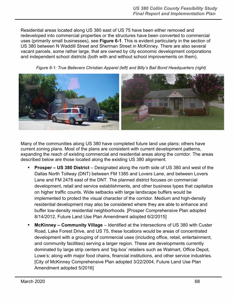
March 2020 68
US 380 Collin County Feasibility Study Final Report and Implementation Plan
Residential areas located along US 380 east of US 75 have been either removed and redeveloped into commercial properties or the structures have been converted to commercial uses (primarily small businesses), see Figure 6-1. This is evident particularly in the section of US 380 between N Waddill Street and Sherman Street in McKinney. There are also several vacant parcels, some rather large, that are owned by city economic development corporations and independent school districts (both with and without school improvements on them).
Many of the communities along US 380 have completed future land use plans; others have current zoning plans. Most of the plans are consistent with current development patterns, expanding the reach of existing commercial and residential areas along the corridor. The areas described below are those located along the existing US 380 alignment.
Prosper – US 380 District – Designated along the north side of US 380 and west of the
Dallas North Tollway (DNT) between FM 1385 and Lovers Lane, and between Lovers
Lane and FM 2478 east of the DNT. The planned district focuses on commercial
development, retail and service establishments, and other business types that capitalize
on higher traffic counts. Wide setbacks with large landscape buffers would be
implemented to protect the visual character of the corridor. Medium and high-density
residential development may also be considered where they are able to enhance and
buffer low-density residential neighborhoods. [Prosper Comprehensive Plan adopted
8/14/2012, Future Land Use Plan Amendment adopted 6/2/2015]
McKinney – Community Village – Identified at the intersections of US 380 with Custer
Road, Lake Forest Drive, and US 75, these locations would be areas of concentrated
development with a grouping of commercial uses (including office, retail, entertainment,
and community facilities) serving a larger region. These are developments currently
dominated by large strip centers and ‘big-box’ retailers such as Walmart, Office Depot,
Lowe’s; along with major food chains, financial institutions, and other service industries.
[City of McKinney Comprehensive Plan adopted 3/22/2004, Future Land Use Plan
Amendment adopted 5/2016]
Figure 6-1: True Believers Christian Apparel (left) and Billy’s Bail Bond Headquarters (right)

March 2020 69
US 380 Collin County Feasibility Study Final Report and Implementation Plan
McKinney – Regional Commercial – Identified along the north side of US 380 south of
New Hope, this area would serve large-scale commercial development providing for
retail and service uses on a regional level. Most of development in this area has
occurred since the mid-1980s, most since 2000. [City of McKinney Comprehensive Plan
adopted 3/22/2004, Future Land Use Plan Amendment adopted 5/2016]
Princeton – Commercial – Except for the Princeton High School campus, the majority
of areas along US 380 are designated for future commercial development. [Future Land
Use Plan updated and adopted 1/23/2017]
Lowry Crossing – Commercial and Highway Commercial – Most of the areas
adjacent to the south side of US 380 are zoned for commercial and highway commercial
uses. These areas would appear to provide a buffer or transition to residential areas
located farther south of the highway. [Lowry Crossing Zoning Map]
Farmersville – Commercial and Mixed Use – Along US 380 and at major
intersections, these areas are to function as service and job destinations with easy
accessibility. Design standards are in place to ensure that commercial buildings will
blend into the community character. [Farmersville Comprehensive Plan adopted
1/24/2013]
McKinney National Airport Master Plan Update – South of existing US 380 and just
east of Airport Drive, the McKinney National Airport recently completed a master plan
update. The update considered the extension of its current runway, as well as a second
parallel runway to the east. Through coordination with McKinney National Airport and
Airport’s consulting staff, the team became aware that a runway protection zone, or
RPZ, exists at the end of each runway. A RPZ exists to restrict land uses within the
vicinity of a runway, should a problem with an aircraft occur during take-off or landing.
The Federal Aviation Administration (FAA) identifies roadways as a hazard within these
RPZs and will take “all possible measures to protect against and remove or mitigate
incompatible land uses” [Interim Guidance on Land Uses Within a Runway Protection
Zone, FAA Memorandum dated 9/27/2012] See Figure 6-2 below for the McKinney
National Airport’s proposed land uses and RPZs. [McKinney National Airport Master
Plan adopted 9/17/2018]

March 2020 70
US 380 Collin County Feasibility Study Final Report and Implementation Plan
6.2 DEVELOPMENT AND POSSIBLE DISPLACEMENTS – RESIDENTIAL AND
COMMERCIAL Throughout the study, TxDOT worked with municipalities to map planned developments. Development status of properties were noted on detailed maps at each public meeting and posted to www.Drive380.com. TxDOT also calculated residential and commercial impacts and displacements. More information about how impacts and displacements were evaluated is available in Section 5.3.1. Totals for displacements and impacts in evaluation segments are available in Section 5.4.2. 6.3 POTENTIAL HISTORIC RESOURCES A desktop analysis and field reconnaissance were conducted to identify historic-age non-archaeological resources, including buildings, structures, objects, districts, etc., that could be considered eligible for listing on the National Register of Historic Places (NRHP). The reconnaissance focused between US 75 in McKinney to the project terminus east of Farmersville. Resources that meet eligibility criteria are provided protection under
Figure 6-2: McKinney National Airport Master Plan

March 2020 71
US 380 Collin County Feasibility Study Final Report and Implementation Plan
Section 106 of the National Historic Preservation Act (NHPA). Section 106 stipulates that project proponents must consider the effects of a proposed project on resources that are determined to be eligible for or already listed on the NRHP. If an adverse effect cannot be avoided or minimized, appropriate mitigation must be provided. Such resources are also provided protection under Section 4(f) of the DOT Act of 1968 (Section 303 Title 409) under which the Secretary of Transportation may approve a project requiring the ‘use’ of publicly owned land of a public park, recreation area, or wildlife/waterfowl refuge, or land of a historic site of national, state, or local significance (as determined by the officials with jurisdiction) only if: (1) there is no feasible and prudent alternative to such use, and (2) the project includes all possible planning to minimize harm. No previously designated NRHP-eligible or NRHP-listed resources or districts (geographically definable area possessing a grouping or linkage of structures united by past events or by character/style or physical development) were identified in the study area. The City of McKinney has designated a Historic Neighborhood Improvement Zone that bounds US 380 on the south, east of US 75, and also extends north of US 380 between Harroun Avenue and College Street. Formal review of the eligibility of these resources would be conducted during the NEPA phase of study through coordination with the Texas Historical Commission (THC) in accordance with TxDOT guidelines.
Three resources were identified that exhibit characteristics that could make them eligible for listing on the NRHP pictured in Figure 6-3, Figure 6-4, and Figure 6-5: McKinney Pharmacy (McKinney), Nixon’s Coin-Op Laundry (McKinney), and the Galloway Memorial Church of God in Christ (Farmersville). Further assessment during the NEPA phase of the project will be necessary to determine if these and/or other resources are NRHP-eligible.
Figure 6-3: McKinney Pharmacy Northside
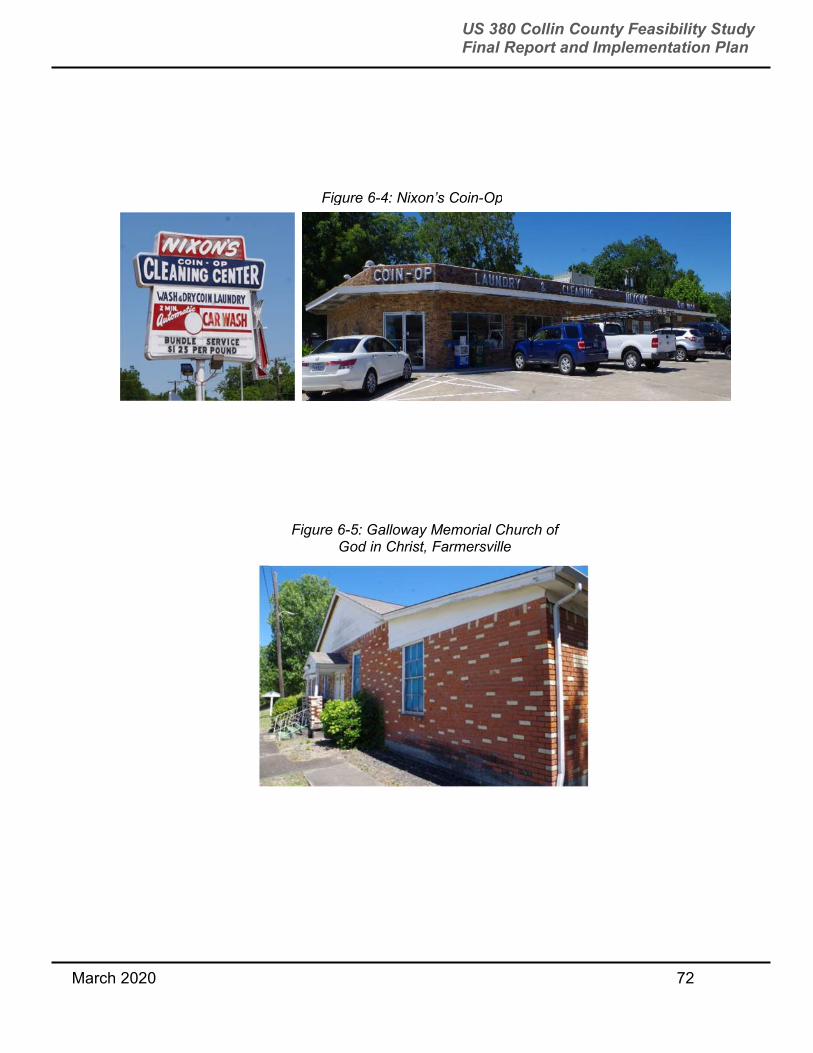
March 2020 72
US 380 Collin County Feasibility Study Final Report and Implementation Plan
Figure 6-4: Nixon’s Coin-Op
Figure 6-5: Galloway Memorial Church of God in Christ, Farmersville

March 2020 73
US 380 Collin County Feasibility Study Final Report and Implementation Plan
Parks and Recreation Areas An inventory of public park, open space, and recreation areas was conducted to determine which properties could be provided protections under Section 4(f). As noted in the previous section, Section 4(f) requires avoidance and planning to minimize harm to publicly owned land of a public park as part of the highway/roadway project that may receive federal funding to avoid a “use” of such property. In addition to addressing Section 4(f), some park or recreation properties may have been acquired or developed with money from the Land and Water Conservation Fund (LWCF) from the National Park Service (NPS). Section 6(f) prohibits the conversion of property acquired or developed with grants from the LWCF to a non-recreational purpose without the approval of the NPS.
Section 4(f) Properties - Numerous city and county-owned parks, greenbelts, trails, school playgrounds, and open space were identified. These must have qualities that satisfy the following specific criteria to be provided protection under section 4(f):
Publicly owned – owned by a public entity through fee simple, permanent easement,
temporary easement, and/or lease agreement (does not apply to historic resources).
Open for public use – the entire public is allowed to access the resource during normal
operating hours; visitation is not limited to a select group(s) (does not apply to refuges).
Major purpose for the property is recreation – the primary purpose is for park,
recreation, or refuge or related activities; activities are other than incidental, secondary,
occasional, or dispersed.
Significant resource – applies to the entire Section 4(f) property, considers the
availability and function of the resource in terms of the objectives of the agency with
jurisdiction, and the property plays an important role in meeting those objectives.
In addition to conducting limited windshield surveys to verify GIS data and reviewing online data sources such as community development plans and park/recreation master plans, the study team also met with City of McKinney planning and parks and recreation staff to review property ownership as well as plans for future development of city-owned parcels for future public use see Figure 6-6 below. To support evaluation of the final alignments, the properties were categorized as follows:
Existing Park – active or passive park/recreation facility as indicated and named in a
community Master Plan. These properties either have existing facilities or an approved
master plan for the development of recreation facilities.
Future Park Expansion – properties shown as high preservation potential (HPP) in the
McKinney Master Plan and indicated by the City/Parks & Recreation departments that
they would be targeted for future park/recreation facility development as need and
funding arise. These properties either do not have existing facilities and may or may not
be open to the public for any type of use.

March 2020 74
US 380 Collin County Feasibility Study Final Report and Implementation Plan
“PIN” Parks – possible future neighborhood park locations indicated in a Master Plan,
but not associated with a specific parcel or development. It is anticipated that these
locations are open for interpretation and once a developer files a plan/plat with the city,
they would negotiate the location/size of a future park/recreation facility.
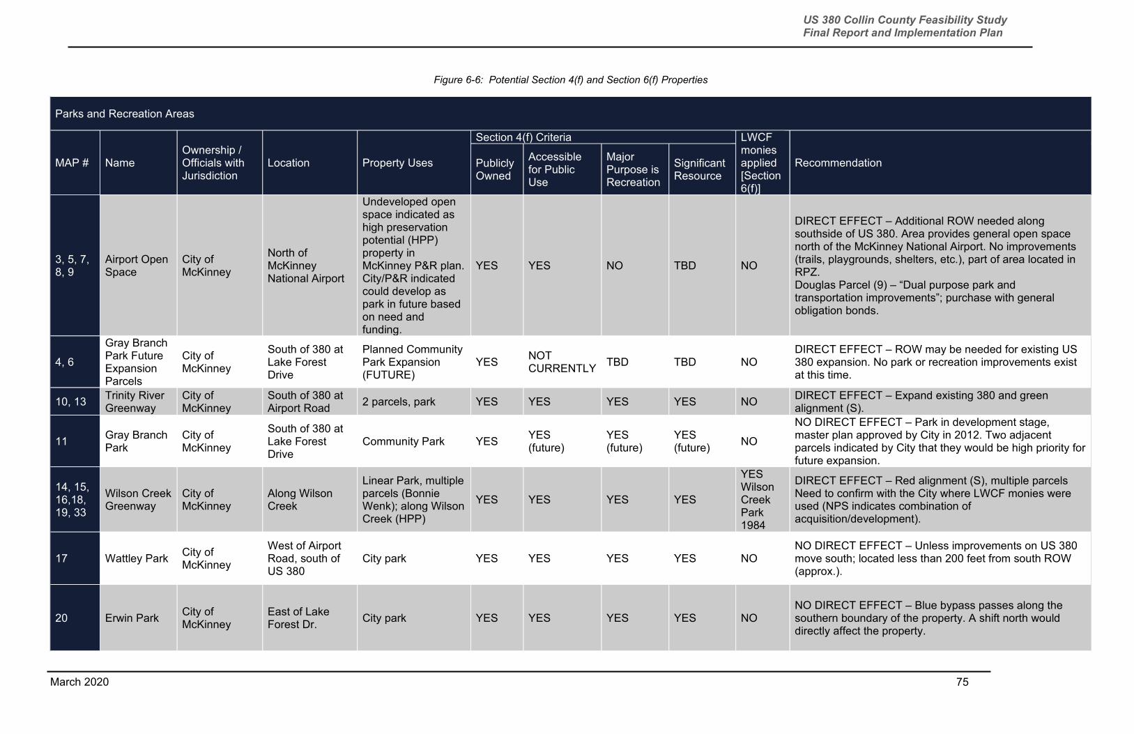
75
US 380 Collin County Feasibility Study Final Report and Implementation Plan
March 2020
Figure 6-6: Potential Section 4(f) and Section 6(f) Properties
Parks and Recreation Areas
MAP # Name Ownership / Officials with Jurisdiction
Location Property Uses
Section 4(f) Criteria LWCF monies applied [Section 6(f)]
Recommendation Publicly Owned
Accessible for Public Use
Major Purpose is Recreation
Significant Resource
3, 5, 7, 8, 9
Airport Open Space
City of McKinney
North of McKinney National Airport
Undeveloped open space indicated as high preservation potential (HPP) property in McKinney P&R plan. City/P&R indicated could develop as park in future based on need and funding.
YES YES NO TBD NO
DIRECT EFFECT – Additional ROW needed along southside of US 380. Area provides general open space north of the McKinney National Airport. No improvements (trails, playgrounds, shelters, etc.), part of area located in RPZ. Douglas Parcel (9) – “Dual purpose park and transportation improvements”; purchase with general obligation bonds.
4, 6
Gray Branch Park Future Expansion Parcels
City of McKinney
South of 380 at Lake Forest Drive
Planned Community Park Expansion (FUTURE)
YES NOT CURRENTLY
TBD TBD NO DIRECT EFFECT – ROW may be needed for existing US 380 expansion. No park or recreation improvements exist at this time.
10, 13 Trinity River Greenway
City of McKinney
South of 380 at Airport Road
2 parcels, park YES YES YES YES NO DIRECT EFFECT – Expand existing 380 and green alignment (S).
11 Gray Branch Park
City of McKinney
South of 380 at Lake Forest Drive
Community Park YES YES (future)
YES (future)
YES (future)
NO
NO DIRECT EFFECT – Park in development stage, master plan approved by City in 2012. Two adjacent parcels indicated by City that they would be high priority for future expansion.
14, 15, 16,18, 19, 33
Wilson Creek Greenway
City of McKinney
Along Wilson Creek
Linear Park, multiple parcels (Bonnie Wenk); along Wilson Creek (HPP)
YES YES YES YES
YES Wilson Creek Park 1984
DIRECT EFFECT – Red alignment (S), multiple parcels Need to confirm with the City where LWCF monies were used (NPS indicates combination of acquisition/development).
17 Wattley Park City of McKinney
West of Airport Road, south of US 380
City park YES YES YES YES NO NO DIRECT EFFECT – Unless improvements on US 380 move south; located less than 200 feet from south ROW (approx.).
20 Erwin Park City of McKinney
East of Lake Forest Dr.
City park YES YES YES YES NO NO DIRECT EFFECT – Blue bypass passes along the southern boundary of the property. A shift north would directly affect the property.

76
US 380 Collin County Feasibility Study Final Report and Implementation Plan
March 2020
MAP # Name Ownership / Officials with Jurisdiction
Location Property Uses
Section 4(f) Criteria LWCF monies applied [Section 6(f)]
Recommendation Publicly Owned
Accessible for Public Use
Major Purpose is Recreation
Significant Resource
21 Old Settler’s Park
City of McKinney
West of Airport Road, south of US 380 (access from Greenville Rd)
City park YES YES YES YES NO NO DIRECT EFFECT – Located approximately 400 feet west of McKinney National Airport Rd (blue alignment).
22 Twin Groves Park
USACE
West end of bridge over Lake Lavon, north of US 380
Regional park YES YES YES YES NO DIRECT EFFECT – Easements or additional ROW along north side of US 380 may be needed to accommodate improvements.
23 Caddo Park USACE
East end of bridge over Lake Lavon, north of US 380
*Park closed until further notice*
YES YES YES YES NO DIRECT EFFECT – Easements or additional ROW along north side of US 380 may be needed to accommodate improvements. Park closed at this time (no public access).
24 Elm Creek Park
USACE
East end of bridge over Lake Lavon, north of US 380
Regional park YES YES YES YES NO
DIRECT EFFECT – Easements or additional ROW along north side of US 380 may be needed to accommodate improvements. Park limits vary by source – need to confirm with USACE.
25
Lake Lavon/Lavon Recreation Area
USACE North of US 380; perimeter of Lake Lavon
Reservoir (water supply and recreation) multi-use recreation, habitat management
YES YES (multi-use property)
YES (multi-use property)
YES NO
DIRECT EFFECT – Easements or additional ROW along existing US 380 may be needed to accommodate improvements. Borders Lake Lavon on all sides, both sides of US 380.
26 Fairview Soccer Complex
Town of Fairview
Old Mill Rd southeast of McKinney National Airport
Soccer complex, controlled by Advanced Youth Soccer Educational System (AYSES) Soccer Club; gated/locked, no public use during non-club use periods
YES NO NO TBD NO
DIRECT EFFECT – Property gated, no public access during period when AYSES club events are not occurring. Schedule posted on website does not indicate public accessibility. AYSES “leases” two other properties in Texas where the same program is supported. Parcel owned by Town of Fairview but located within the McKinney city limits.
27, 28 Nature Preserve (future)
Town of Fairview
Old Mill Rd south of McKinney National Airport
Current – pasture/ag; gated (no public access)
YES NO NO TBD NO
DIRECT EFFECT – Property currently gated and not publicly accessible, currently used for agriculture (pasture); parcel owned by Town of Fairview but located within the McKinney city limits.
29
Forest Grove Phase I Amenity Center
City of Princeton
East of Monte Carlo Blvd, north of US 380
Platted/planned as amenity center for neighborhood
YES TBD TBD TBD NO NO DIRECT EFFECT – Under development, located approx. 900 feet north of US 380.

77
US 380 Collin County Feasibility Study Final Report and Implementation Plan
March 2020
MAP # Name Ownership / Officials with Jurisdiction
Location Property Uses
Section 4(f) Criteria LWCF monies applied [Section 6(f)]
Recommendation Publicly Owned
Accessible for Public Use
Major Purpose is Recreation
Significant Resource
30
JM Caldwell Sr. Community Park (Princeton Community Park)
City of Princeton
500 W. College Street (more than 1000 feet north of US 380)
Community Park (WWII POW Camp)
YES YES YES YES NO NO DIRECT EFFECT – Egress easement tied to US 380.
38 La Cima Lake & Park
Town of Prosper
US 380 and north Stonebridge Dr.
Greenbelt/trail corridor, associated with a residential development (Lakes of La Cima Homes)
YES TBD TBD TBD NO DIRECT EFFECT – Additional ROW along south side of US 380. Open space for the Lakes of La Cima Homes development.
39 Ridgecrest Dog Park
City of McKinney
West of south Ridge Road, south of US 380 Trail Side Dr./Valley View Dr.)
Dog park YES YES YES YES NO NO DIRECT EFFECT – Less than 0.1 miles south of US 380.
40
Heard National Science Museum and Wildlife Sanctuary
Heard National Science Museum and Wildlife Sanctuary
Southwest of McKinney National Airport, west of Fairview Nature Preserve
Main facility at 1 Nature Place, McKinney
NO TBD TBD YES NO NO DIRECT EFFECT – If the red bypass alignment would shift, could be directly affected.
NOTES: * Based on review of LWCF listing for Collin County TX conducted October 2017. Many entries indicate general projects (e.g., City of McKinney Parks Improvements) with no reference to a specific property. Coordination with the applicable city/county is required to determine whether LWCF monies were used for individual properties. See LWCF Listing for Collin County TX in Attachment 1. TPWD LWRCRP – The Land and Water Resources Conservation and Recreation Plan (LWRCRP) is a planning document for TPWD. Properties are inventoried every 10 years. It has no legal effect on properties. The codes used are described at https://tpwd.texas.gov/gis/apps/lwrcrp/. The TPWD LWRCRP page is located at https://tpwd.texas.gov/publications/land-and-water-plan.
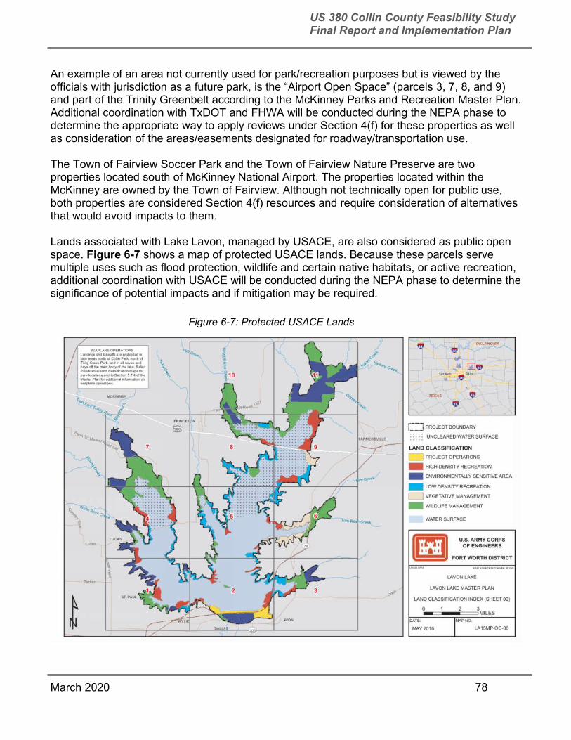
March 2020 78
US 380 Collin County Feasibility Study Final Report and Implementation Plan
An example of an area not currently used for park/recreation purposes but is viewed by the officials with jurisdiction as a future park, is the “Airport Open Space” (parcels 3, 7, 8, and 9) and part of the Trinity Greenbelt according to the McKinney Parks and Recreation Master Plan. Additional coordination with TxDOT and FHWA will be conducted during the NEPA phase to determine the appropriate way to apply reviews under Section 4(f) for these properties as well as consideration of the areas/easements designated for roadway/transportation use.
The Town of Fairview Soccer Park and the Town of Fairview Nature Preserve are two properties located south of McKinney National Airport. The properties located within the McKinney are owned by the Town of Fairview. Although not technically open for public use, both properties are considered Section 4(f) resources and require consideration of alternatives that would avoid impacts to them.
Lands associated with Lake Lavon, managed by USACE, are also considered as public open space. Figure 6-7 shows a map of protected USACE lands. Because these parcels serve multiple uses such as flood protection, wildlife and certain native habitats, or active recreation, additional coordination with USACE will be conducted during the NEPA phase to determine the significance of potential impacts and if mitigation may be required.
Figure 6-7: Protected USACE Lands

March 2020 79
US 380 Collin County Feasibility Study Final Report and Implementation Plan
Section 6(f) Properties – The parcels known as Wilson Creek Park within the Wilson Creek Greenway indicated on the park map as 14, 15, 16,18, 19, 33 were acquired with LWCF monies in 1984. Determining the actual parcel boundaries acquired with LWCF monies and the final alignment and footprint of Spur 399 will be completed during the NEPA phase to determine what type of effects may result to the 6(f) property. At that time, the determination will be made whether the significance of the impact warrants a land conversion or if impacts can be minimized with minimal mitigation.
Natural Habitats
The US 380 corridor crosses numerous streams and tributaries that contribute to the East Fork of the Trinity River. Wilson Creek is a prominent drainage primarily located south of US 380. As noted previously, the City of McKinney owns a number of parcels along Wilson Creek and the East Fork of the Trinity River reserving these areas for future open space/recreational use but also to support regional and local floodplain management practices. No field surveys were conducted during the study to verify wetland or forest resources; but a high-level review of published GIS data indicated that these areas maintain features consistent with emergent, shrub-scrub, and forested wetlands as well as bottomland hardwood forests common to north Texas.
There are several species federally and state-listed for Collin County; the majority of which are migratory or need certain habitats that are not found within the US 380 corridor. Additional investigation and coordination would be conducted during the NEPA phase to determine what species and habitats may be present and what type of impact a proposed project may have on them. Collin County streams support two state-listed species of mussels (mollusk) that could occur within Wilson Creek and the East Fork of the Trinity River. Additional assessment and coordination with the Texas Parks and Wildlife Department (TPWD) would be conducted during the NEPA phase to address potential effects on mussels. Impacts to migratory birds and supporting habitats would also be addressed at that time.
Wetland field delineations would be conducted during the NEPA phase to determine the jurisdictional limits of such features to assist in determining the impacts of the proposed projects, the type of permit required, and the amount of mitigation, if required. In addition, field surveys may be needed to identify the presence of habitat suitable to support protected species and that of migratory birds that may be affected by a proposed project.
Socio-Economic Issues US Census data (2010 and 2017) were used to determine the potential location of minority and low-income populations within the study area that may be affected by the proposed improvements. This review was focused along the existing US 380 corridor and the area west of the McKinney National Airport. These areas may be considered as potential environmental justice communities which are neighborhoods with a high percentage of minority and/or low-income residents. As part of the NEPA phase, additional data analysis and assessment of impacts would be conducted to determine if the alternatives carried forward result in possible disproportionately high or adverse effects in compliance with Executive Order
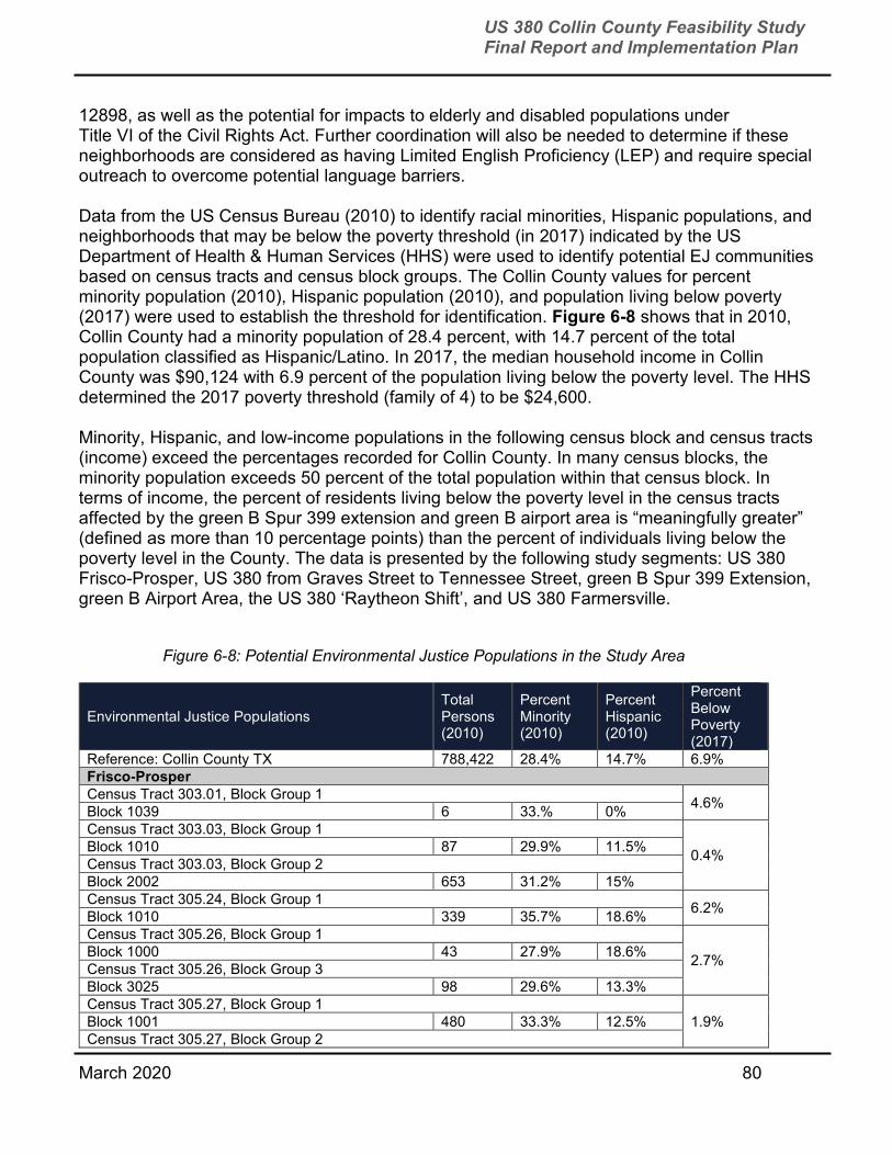
March 2020 80
US 380 Collin County Feasibility Study Final Report and Implementation Plan
12898, as well as the potential for impacts to elderly and disabled populations under Title VI of the Civil Rights Act. Further coordination will also be needed to determine if these neighborhoods are considered as having Limited English Proficiency (LEP) and require special outreach to overcome potential language barriers. Data from the US Census Bureau (2010) to identify racial minorities, Hispanic populations, and neighborhoods that may be below the poverty threshold (in 2017) indicated by the US Department of Health & Human Services (HHS) were used to identify potential EJ communities based on census tracts and census block groups. The Collin County values for percent minority population (2010), Hispanic population (2010), and population living below poverty (2017) were used to establish the threshold for identification. Figure 6-8 shows that in 2010, Collin County had a minority population of 28.4 percent, with 14.7 percent of the total population classified as Hispanic/Latino. In 2017, the median household income in Collin County was $90,124 with 6.9 percent of the population living below the poverty level. The HHS determined the 2017 poverty threshold (family of 4) to be $24,600. Minority, Hispanic, and low-income populations in the following census block and census tracts (income) exceed the percentages recorded for Collin County. In many census blocks, the minority population exceeds 50 percent of the total population within that census block. In terms of income, the percent of residents living below the poverty level in the census tracts affected by the green B Spur 399 extension and green B airport area is “meaningfully greater” (defined as more than 10 percentage points) than the percent of individuals living below the poverty level in the County. The data is presented by the following study segments: US 380 Frisco-Prosper, US 380 from Graves Street to Tennessee Street, green B Spur 399 Extension, green B Airport Area, the US 380 ‘Raytheon Shift’, and US 380 Farmersville.
Figure 6-8: Potential Environmental Justice Populations in the Study Area
Environmental Justice Populations Total Persons (2010)
Percent Minority (2010)
Percent Hispanic (2010)
Percent Below Poverty (2017)
Reference: Collin County TX 788,422 28.4% 14.7% 6.9% Frisco-Prosper Census Tract 303.01, Block Group 1
4.6% Block 1039 6 33.% 0% Census Tract 303.03, Block Group 1
0.4% Block 1010 87 29.9% 11.5% Census Tract 303.03, Block Group 2 Block 2002 653 31.2% 15% Census Tract 305.24, Block Group 1
6.2% Block 1010 339 35.7% 18.6% Census Tract 305.26, Block Group 1
2.7% Block 1000 43 27.9% 18.6% Census Tract 305.26, Block Group 3 Block 3025 98 29.6% 13.3% Census Tract 305.27, Block Group 1
1.9% Block 1001 480 33.3% 12.5% Census Tract 305.27, Block Group 2
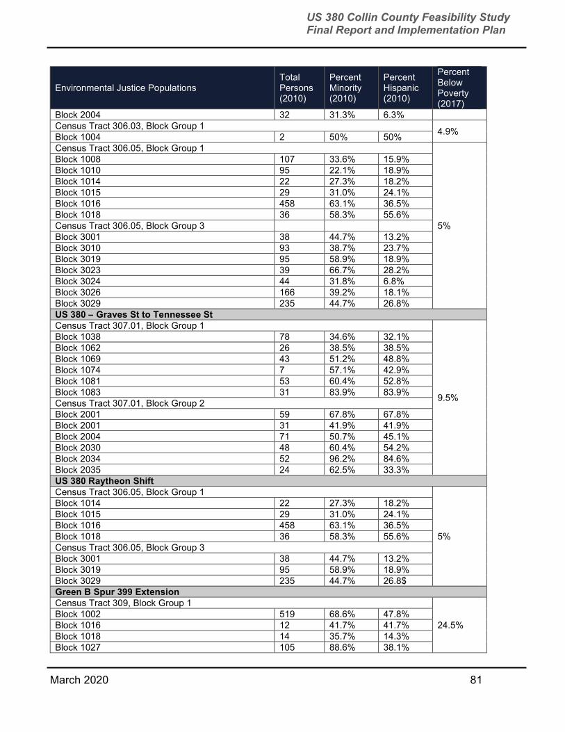
March 2020 81
US 380 Collin County Feasibility Study Final Report and Implementation Plan
Environmental Justice Populations Total Persons (2010)
Percent Minority (2010)
Percent Hispanic (2010)
Percent Below Poverty (2017)
Block 2004 32 31.3% 6.3% Census Tract 306.03, Block Group 1
4.9% Block 1004 2 50% 50% Census Tract 306.05, Block Group 1
5%
Block 1008 107 33.6% 15.9% Block 1010 95 22.1% 18.9% Block 1014 22 27.3% 18.2% Block 1015 29 31.0% 24.1% Block 1016 458 63.1% 36.5% Block 1018 36 58.3% 55.6% Census Tract 306.05, Block Group 3 Block 3001 38 44.7% 13.2% Block 3010 93 38.7% 23.7% Block 3019 95 58.9% 18.9% Block 3023 39 66.7% 28.2% Block 3024 44 31.8% 6.8% Block 3026 166 39.2% 18.1% Block 3029 235 44.7% 26.8% US 380 – Graves St to Tennessee St Census Tract 307.01, Block Group 1
9.5%
Block 1038 78 34.6% 32.1% Block 1062 26 38.5% 38.5% Block 1069 43 51.2% 48.8% Block 1074 7 57.1% 42.9% Block 1081 53 60.4% 52.8% Block 1083 31 83.9% 83.9% Census Tract 307.01, Block Group 2 Block 2001 59 67.8% 67.8% Block 2001 31 41.9% 41.9% Block 2004 71 50.7% 45.1% Block 2030 48 60.4% 54.2% Block 2034 52 96.2% 84.6% Block 2035 24 62.5% 33.3% US 380 Raytheon Shift Census Tract 306.05, Block Group 1
5%
Block 1014 22 27.3% 18.2% Block 1015 29 31.0% 24.1% Block 1016 458 63.1% 36.5% Block 1018 36 58.3% 55.6% Census Tract 306.05, Block Group 3 Block 3001 38 44.7% 13.2% Block 3019 95 58.9% 18.9% Block 3029 235 44.7% 26.8$ Green B Spur 399 Extension Census Tract 309, Block Group 1
24.5% Block 1002 519 68.6% 47.8% Block 1016 12 41.7% 41.7% Block 1018 14 35.7% 14.3% Block 1027 105 88.6% 38.1%

March 2020 82
US 380 Collin County Feasibility Study Final Report and Implementation Plan
Environmental Justice Populations Total Persons (2010)
Percent Minority (2010)
Percent Hispanic (2010)
Percent Below Poverty (2017)
Block 1044 62 90.3% 79.0% Block 1048 17 88.2% 64.7% Block 1050 1 100% 0% Block 1051 34 82.4% 64.7% Green B Airport Area Census Tract 309, Block Group 3
24.5%
Block 3000 196 82.7% 80.1% Block 3023 235 19.6% 15.4% Block 3025 25 64.0% 64.0% Block 3027 21 95.2% 95.2% Block 3028 14 42.9% 35.7% Block 3029 17 52.9% 52.9% Block 3073 210 92.9% 91.9% Block 3074 110 84.5% 82.7% Block 3075 28 100% 100% Census Tract 309, Block Group 3 Block 4007 457 91.2% 49.2% Block 4019 10 80.0% 80.0% Block 4020 26 96.2% 96.2% Block 4036 36 50.0% 47.2% Block 4037 48 35.4% 27.1% US 380 Farmersville Census Tract 311, Block Group 4
5.1% Block 4024 13 61.5% 7.7% Block 4032 17 88.2% 23.5% Block 4033 8 100% 0% Source: US Census Bureau race/ethnicity data (including Hispanic) is available to the Block and Block Group level; income and percent of the population living below the poverty level is only available to the Census Tract level.
6.4 INITIAL NOISE ANALYSIS An initial noise analysis, consisting of noise measurements and preliminary traffic noise modeling, was performed for select areas along the recommended alignment.
Noise is a value that is measured on a logarithmic scale. See Figure 6-9 for common noise situations and the corresponding noise level described in decibels (dBA).
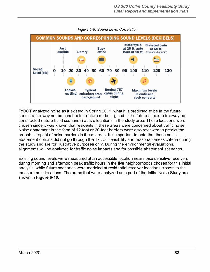
March 2020 83
US 380 Collin County Feasibility Study Final Report and Implementation Plan
TxDOT analyzed noise as it existed in Spring 2019, what it is predicted to be in the future should a freeway not be constructed (future no-build), and in the future should a freeway be constructed (future build scenarios) at five locations in the study area. These locations were chosen since it was known that residents in these areas were concerned about traffic noise. Noise abatement in the form of 12-foot or 20-foot barriers were also reviewed to predict the probable impact of noise barriers in these areas. It is important to note that these noise abatement options did not go through the TxDOT feasibility and reasonableness criteria during the study and are for illustrative purposes only. During the environmental evaluations, alignments will be analyzed for traffic noise impacts and for possible abatement scenarios.
Existing sound levels were measured at an accessible location near noise sensitive receivers during morning and afternoon peak traffic hours in the five neighborhoods chosen for this initial analysis; while future scenarios were modeled at residential receiver locations closest to the measurement locations. The areas that were analyzed as a part of the Initial Noise Study are shown in Figure 6-10.
Figure 6-9: Sound Level Correlation

March 2020 84
US 380 Collin County Feasibility Study Final Report and Implementation Plan
The future no-build scenario was modeled using 2045 traffic data and other expected roadway alignment expansions in Collin County. In many areas, the traffic volumes and number of lanes increased, but the roadway elevation remained relatively consistent with the existing conditions.
The future build scenario for US 380 was modeled using 2045 traffic volume projections and roadway layouts. The freeway is currently planned to be depressed in some locations. These changes in elevations were considered if roadway depressions occurred near a neighborhood of known concern. The change in elevation could alter the way noise propagates from the roadway and was included in the future build modeled scenarios to most-accurately capture this affect. In some areas, the modeled sound estimates for the future build scenario decrease from the future no-build scenario, since 2045 traffic volumes on some Collin County planned roadways will decrease if US 380 is constructed as a freeway.
Many factors (topography, project traffic, other traffic, traffic speed and composition, etc.) were incorporated into the future no-build and future build models to provide an estimate of the cumulative traffic sound levels at the residential receivers. Variances in these factors between receivers and scenarios will influence the modeled sound levels at the residential receivers. To illustrate the changes that noise abatement may be able to provide, a 12-foot and a 20-foot barrier were both included in these initial modeling runs. Figure 6-11 shows the results of this initial analysis.
Figure 6-10: Areas Studied during Initial Noise Analysis
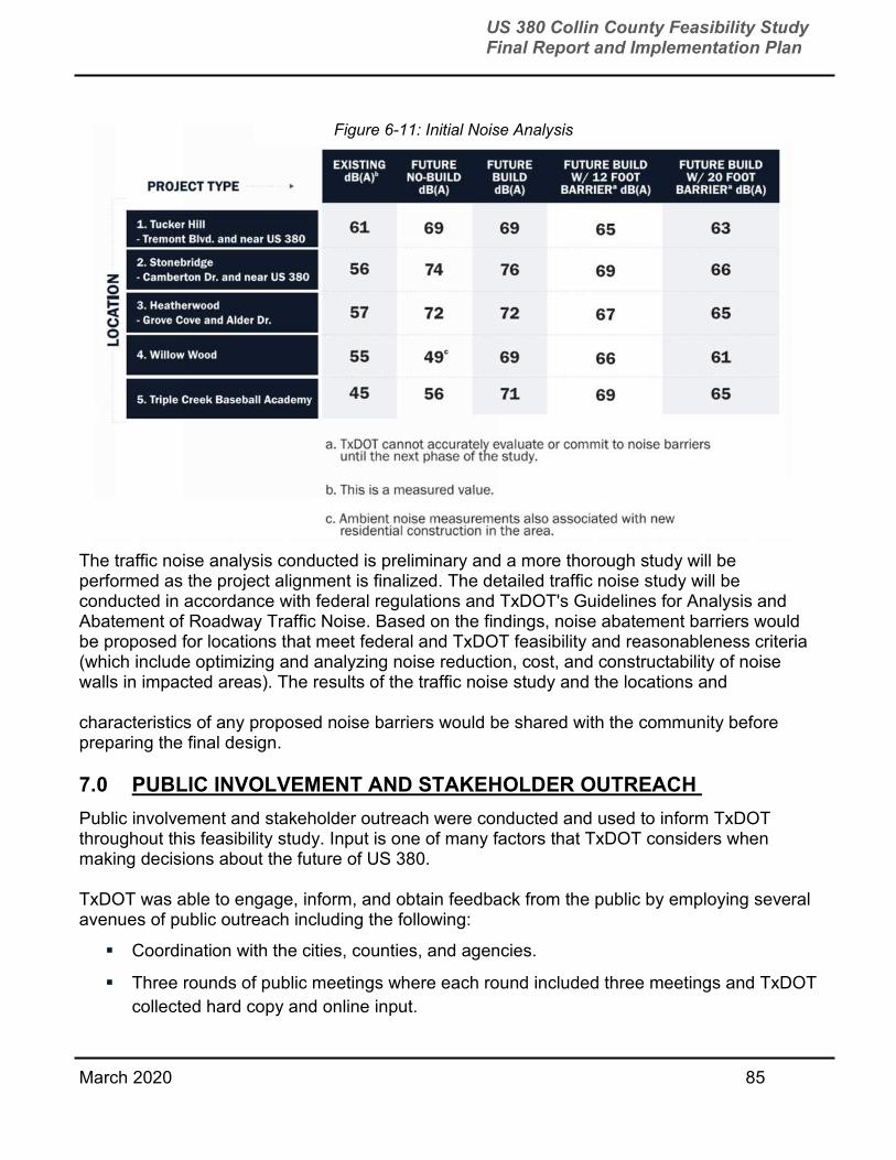
March 2020 85
US 380 Collin County Feasibility Study Final Report and Implementation Plan
The traffic noise analysis conducted is preliminary and a more thorough study will be performed as the project alignment is finalized. The detailed traffic noise study will be conducted in accordance with federal regulations and TxDOT's Guidelines for Analysis and Abatement of Roadway Traffic Noise. Based on the findings, noise abatement barriers would be proposed for locations that meet federal and TxDOT feasibility and reasonableness criteria (which include optimizing and analyzing noise reduction, cost, and constructability of noise walls in impacted areas). The results of the traffic noise study and the locations and
characteristics of any proposed noise barriers would be shared with the community before preparing the final design.
7.0 PUBLIC INVOLVEMENT AND STAKEHOLDER OUTREACH
Public involvement and stakeholder outreach were conducted and used to inform TxDOT throughout this feasibility study. Input is one of many factors that TxDOT considers when making decisions about the future of US 380.
TxDOT was able to engage, inform, and obtain feedback from the public by employing several avenues of public outreach including the following:
Coordination with the cities, counties, and agencies.
Three rounds of public meetings where each round included three meetings and TxDOT
collected hard copy and online input.
Figure 6-11: Initial Noise Analysis

March 2020 86
US 380 Collin County Feasibility Study Final Report and Implementation Plan
Two MAPOs.
Small group and stakeholder work group meetings.
Appendix B provides a list of all meetings with stakeholders held by TxDOT and the study team during the study.
7.1 PUBLIC MEETINGS AND MAPOS Three rounds of three public meetings and two MAPOs were hosted by TxDOT. All public meeting materials and summaries, including comment response matrices, are posted at www.Drive380.com.
Spring 2018
The first round of public meetings was held to present and get feedback on the study’s purpose, possible options for improvements, and five feasible freeway alignments. Meeting #1 took place on April 26, 2018 at Sheraton McKinney, Meeting #2 took place on May 1, 2018 at Princeton High School, and Meeting #3 took place on May 3, 2018 at Lorene Rogers Middle School. A total of 1,120 people attended the meetings and 4,452 surveys and comments were received.
Fall 2018
The second round of public meetings was held to present and get feedback on two freeway alignments with options. Meeting #1 took place on October 4, 2018 at Independence High School, Meeting #2 took place on October 9, 2018 at Collin College Central Park Campus Conference Center, and Meeting #3 took place on October 11, 2018 at Princeton High School. A total of 949 people attended the meetings and 10,750 surveys and comments were received.
Meeting of Affected Property Owners (MAPO) Two MAPOs were held with property owners who were within 1,000 feet of newly proposed alignment segments in the Northeast McKinney area and the area in East Prosper and West McKinney. Meeting #1 was held on March 21, 2019 in the Jury Room at Russell A. Steindam Courts Building. Meeting #2 took place on March 28, 2019 at Lorene Rogers Middle School. A total of 546 people attended the meetings and 1,213 surveys and comments were received.
Spring 2019
The final round of public meetings was to present TxDOT’s recommended alignment and additional study information. Meeting #1 took place on May 6, 2019 at Russell A. Steindam Courts Building, Meeting #2 took place on May 7, 2019 at Princeton High School, and Meeting #3 took place on May 9, 2019 at Rogers Middle School. A total of 864 people attended the meetings and 1,827 surveys and comments were received.
Figure 7-1 provides the large public meetings that were held during the feasibility study, the number of meeting attendees, and the number of comments/surveys that were received during the public comment period.
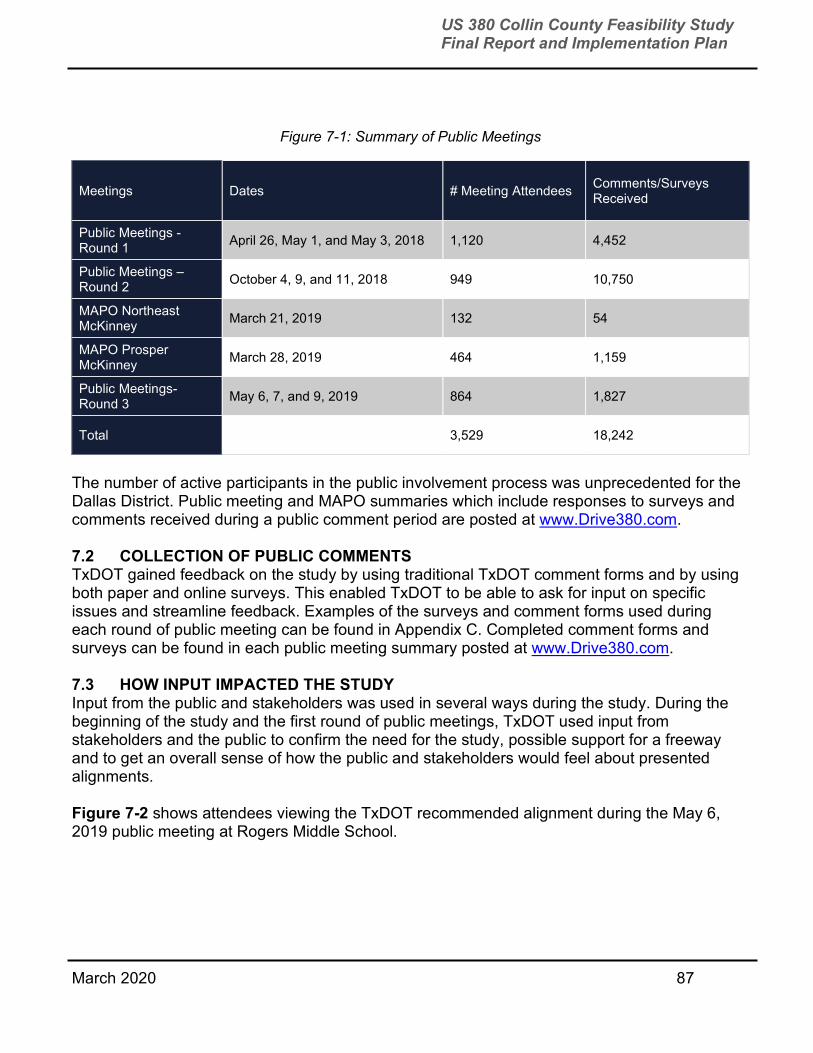
March 2020 87
US 380 Collin County Feasibility Study Final Report and Implementation Plan
The number of active participants in the public involvement process was unprecedented for the Dallas District. Public meeting and MAPO summaries which include responses to surveys and comments received during a public comment period are posted at www.Drive380.com.
7.2 COLLECTION OF PUBLIC COMMENTS TxDOT gained feedback on the study by using traditional TxDOT comment forms and by using both paper and online surveys. This enabled TxDOT to be able to ask for input on specific issues and streamline feedback. Examples of the surveys and comment forms used during each round of public meeting can be found in Appendix C. Completed comment forms and surveys can be found in each public meeting summary posted at www.Drive380.com.
7.3 HOW INPUT IMPACTED THE STUDY Input from the public and stakeholders was used in several ways during the study. During the beginning of the study and the first round of public meetings, TxDOT used input from stakeholders and the public to confirm the need for the study, possible support for a freeway and to get an overall sense of how the public and stakeholders would feel about presented alignments.
Figure 7-2 shows attendees viewing the TxDOT recommended alignment during the May 6, 2019 public meeting at Rogers Middle School.
Figure 7-1: Summary of Public Meetings
Meetings Dates # Meeting Attendees Comments/Surveys Received
Public Meetings - Round 1
April 26, May 1, and May 3, 2018 1,120 4,452
Public Meetings – Round 2
October 4, 9, and 11, 2018 949 10,750
MAPO Northeast McKinney
March 21, 2019 132 54
MAPO Prosper McKinney
March 28, 2019 464 1,159
Public Meetings- Round 3
May 6, 7, and 9, 2019 864 1,827
Total 3,529 18,242
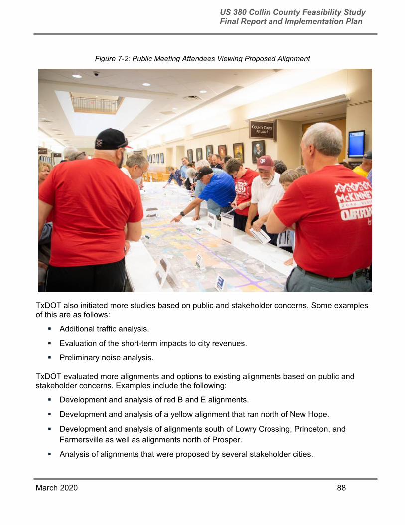
March 2020 88
US 380 Collin County Feasibility Study Final Report and Implementation Plan
TxDOT also initiated more studies based on public and stakeholder concerns. Some examples of this are as follows:
Additional traffic analysis.
Evaluation of the short-term impacts to city revenues.
Preliminary noise analysis.
TxDOT evaluated more alignments and options to existing alignments based on public and stakeholder concerns. Examples include the following:
Development and analysis of red B and E alignments.
Development and analysis of a yellow alignment that ran north of New Hope.
Development and analysis of alignments south of Lowry Crossing, Princeton, and
Farmersville as well as alignments north of Prosper.
Analysis of alignments that were proposed by several stakeholder cities.
Figure 7-2: Public Meeting Attendees Viewing Proposed Alignment
March 2020 89
US 380 Collin County Feasibility Study Final Report and Implementation Plan
Development and analysis of shifting slightly the green alignment north and south to
avoid or minimize impacts to various places such as major businesses/employers,
churches, and assisted living facilities.
Analysis of depression and compression of alignments.
Analysis of where it might be feasible to eliminate frontage roads.
Analysis of an elevated typical section along the green alignment through McKinney.
7.4 LOCAL GOVERNMENT COORDINATION Throughout the study, TxDOT worked to coordinate the study with local governments. TxDOT conducted small group meetings with key elected officials and/or staff; hosted a technical work group meeting on September 7, 2017; and presented to city/town councils and the Collin County Commissioners Court. Dates for these meetings/presentations can be found in Appendix B.
Collin County On May 7, 2019, the Collin County Commissioners Court passed a resolution supporting the green alignment along the existing US 380 from the Denton County line and FM 1827. The resolution can be found in Appendix A. It is important to note that there have been subsequent resolutions supporting other alternatives considered but not passed by the Commissioners Court.
Town of Prosper The Council passed a resolution in full support of what TxDOT presented on May 6, 2019, which includes TxDOT’s recommended alignment. The resolution directs staff to coordinate with TxDOT or any other entity related to the preservation of right of way for the recommended alignment. This was the final resolution provided by the Town during the study and can be found in Appendix A.

March 2020 90
US 380 Collin County Feasibility Study Final Report and Implementation Plan
City of Frisco The City of Frisco did not take a formal position on the study during the feasibility study. The Council did pass a resolution in 2016 that supported US 380, within its city limits, as a future limited access roadway. The 2016 resolution can be found in Appendix A.
City of McKinney TxDOT met with City of McKinney staff and presented to McKinney City Council. A resolution was passed by the Council on October 15, 2019. TxDOT received a joint letter from the City of McKinney and Town of Fairview on August 26, 2019 regarding the recommended alignment, specifically the area south of McKinney National Airport. These documents and correspondence from McKinney City Manager Paul Grimes regarding TxDOT’s recommended alignment can be found in Appendix A.
Figure 7-3: TxDOT PM Stephen Endres presents to Town of Prosper Council
Photo courtesy of Dallas Morning News, Jason Janik/Special Contributor (July 2018)
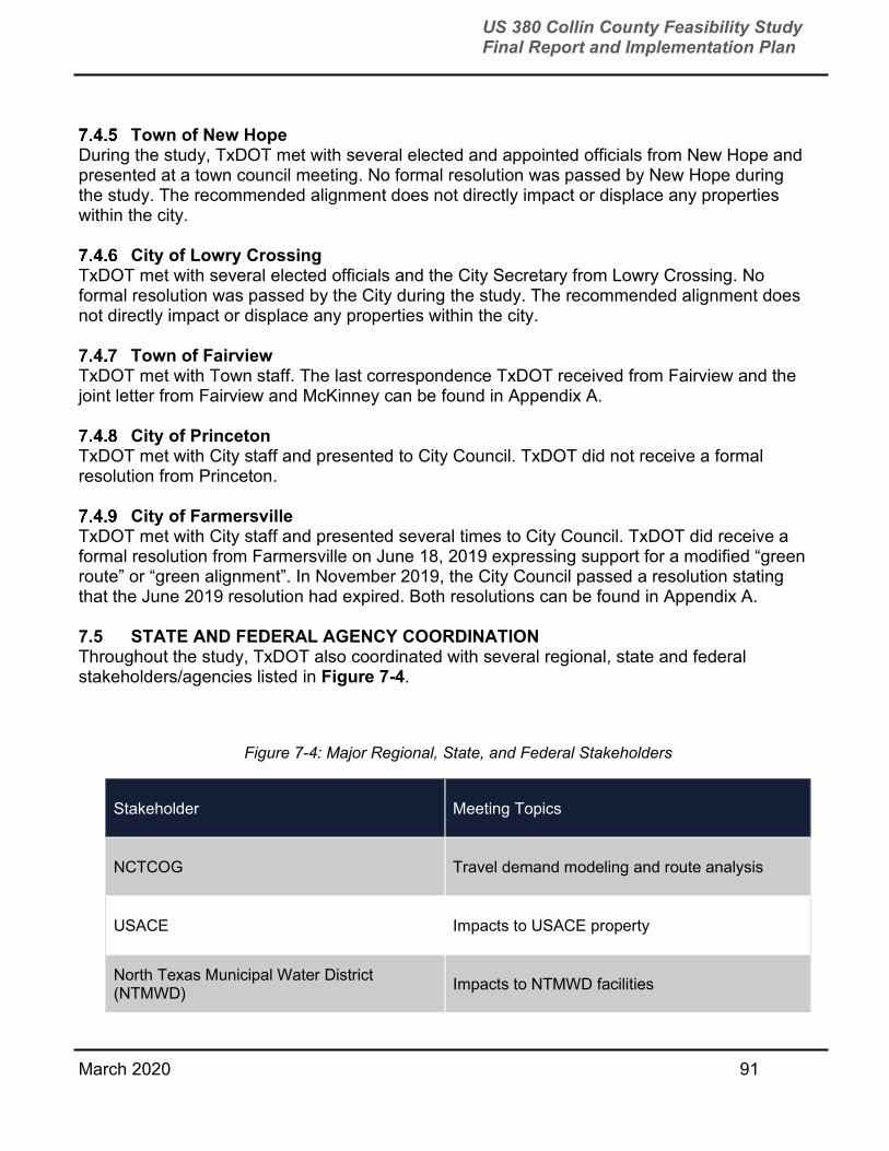
March 2020 91
US 380 Collin County Feasibility Study Final Report and Implementation Plan
Town of New Hope During the study, TxDOT met with several elected and appointed officials from New Hope and presented at a town council meeting. No formal resolution was passed by New Hope during the study. The recommended alignment does not directly impact or displace any properties within the city.
City of Lowry Crossing TxDOT met with several elected officials and the City Secretary from Lowry Crossing. No formal resolution was passed by the City during the study. The recommended alignment does not directly impact or displace any properties within the city.
Town of Fairview TxDOT met with Town staff. The last correspondence TxDOT received from Fairview and the joint letter from Fairview and McKinney can be found in Appendix A.
City of Princeton TxDOT met with City staff and presented to City Council. TxDOT did not receive a formal resolution from Princeton.
City of Farmersville TxDOT met with City staff and presented several times to City Council. TxDOT did receive a formal resolution from Farmersville on June 18, 2019 expressing support for a modified “green route” or “green alignment”. In November 2019, the City Council passed a resolution stating that the June 2019 resolution had expired. Both resolutions can be found in Appendix A. 7.5 STATE AND FEDERAL AGENCY COORDINATION Throughout the study, TxDOT also coordinated with several regional, state and federal stakeholders/agencies listed in Figure 7-4.
Figure 7-4: Major Regional, State, and Federal Stakeholders
Stakeholder Meeting Topics
NCTCOG Travel demand modeling and route analysis
USACE Impacts to USACE property
North Texas Municipal Water District (NTMWD)
Impacts to NTMWD facilities

March 2020 92
US 380 Collin County Feasibility Study Final Report and Implementation Plan
Stakeholder Meeting Topics
City of Irving Conflicts with Irving Water Line
7.6 STAKEHOLDER WORK GROUPS After each round of public meetings, TxDOT coordinated stakeholder work group meetings to discuss the project in more detail with those potentially impacted or displaced by presented alignments. Invitees included the following:
Business owners, business representatives, and Chamber of Commerce staff.
Neighborhood and HOA leaders.
School district representatives and Collin College leadership.
Police, Fire, and EMS representatives. 7.7 ONLINE OUTREACH AND WEBSITE The study webpage can be found at www.Drive380.com; including:
Detailed alignment route maps presented at each public meeting.
Public meeting and MAPO summaries.
Environmental constraints map.
Travel time estimator tool.
FAQ’s.
Presentation slides and boards from all the public meetings and affected property owner
meetings.
As of September 2019, 1,176 people have signed up on www.Drive380.com to receive updates about the study. The study webpage is shown in Figure 7-5.

March 2020 93
US 380 Collin County Feasibility Study Final Report and Implementation Plan
Figure 7-5: Project Webpage
March 2020 94
US 380 Collin County Feasibility Study Final Report and Implementation Plan

March 2020 95
US 380 Collin County Feasibility Study Final Report and Implementation Plan

March 2020 96
US 380 Collin County Feasibility Study Final Report and Implementation Plan
March 2020 97
US 380 Collin County Feasibility Study Final Report and Implementation Plan

March 2020 98
US 380 Collin County Feasibility Study Final Report and Implementation Plan
7.8 DATABASE/MAILING LIST Several databases were maintained throughout the study. These databases were primarily used by the project team to send meeting notices. Databases included:
Mailing and physical addresses for property owners within a quarter mile buffer of
alignments presented at public meetings.
Major stakeholders, elected officials, and agency representatives.
Potential stakeholder work group members including business owners/representatives,
neighborhood leader or representative of a neighborhood association.
Interested persons who requested to receive updates/meeting notices.
March 2020 99
US 380 Collin County Feasibility Study Final Report and Implementation Plan
8.0 ECONOMIC ANALYSIS
The economic analysis conducted includes two separate studies:
Property and sales tax revenue impact associated with the red and green alignments.
Land development potential of each alignment. 8.1 ECONOMIC IMPACT ANALYSIS BY CITY (SALES AND PROPERTY TAX) The sales tax analysis considered the net loss of municipal sales tax revenue attributed to businesses located on parcels impacted by each alignment. The analysis used share of total building area, in terms of square feet, as a proxy for share of sales tax revenue, since sales tax revenue is not available for individual businesses. The methodology calculated the total building area, as reported by the Collin County Tax Assessor-Collector, associated with parcels taken within each alignment. For parcels where a partial taking is estimated, the total building area was multiplied by 50 percent. The sum of building area on impacted parcels was divided by the total building area within the respective jurisdiction. The resulting percentage was multiplied by that jurisdiction’s projected annual sales tax revenue for 2019 to estimate the impact. The property tax impact analysis uses a similar methodology as the sales tax impact analysis but can more directly estimate revenue impacts since property value information is available at the parcel level. For parcels where a partial taking was estimated, the certified assessed value was multiplied by a value of either 10 or 50 percent, depending on the level of impact. The sum of the certified assessed value was then multiplied by property tax rate of the respective taxing entity (either city or ISD). The property tax rate is the adopted rate for 2018 as reported by the Tax Assessor-Collector. The results of the economic impact analysis are summarized in Figure 8-1. Economic impacts associated with the green alignment are higher than impacts associated with the red alignment, both cumulatively and at the jurisdiction level. The total economic impact of the green alignment is approximately $9.4 million, representing about 1.62 percent of the cumulative annual property and sales tax revenue for all jurisdictions in the county. The total economic impact of the red alignment is approximately $1.8 million, representing about 0.31 percent of the cumulative annual property and sales tax revenue. In terms of absolute revenue, jurisdiction impacts associated with the green alignment ranged from a low of zero for the Frisco ISD to a high of $4.6 million for the McKinney ISD. In terms of percentage of revenue base, impacts ranged from a low of zero for the Frisco ISD to a high of just over five percent for the City of Princeton. Absolute revenue impacts associated with the red alignment ranged from a low of zero for the City of Farmersville to a high of $833,000 for the McKinney ISD. Relative impacts ranged from a low of zero for the City of Farmersville to a high of 0.54 percent for the Town of Prosper.
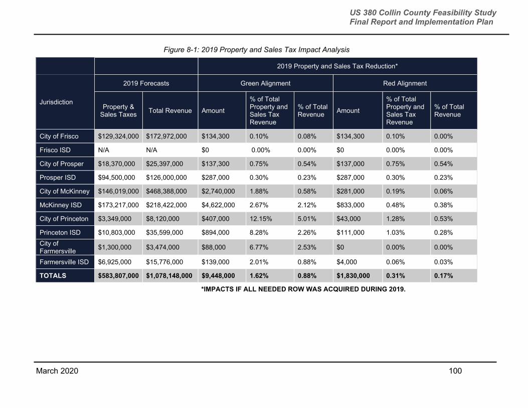
March 2020 100
US 380 Collin County Feasibility Study Final Report and Implementation Plan
Figure 8-1: 2019 Property and Sales Tax Impact Analysis
2019 Property and Sales Tax Reduction*
Jurisdiction
2019 Forecasts Green Alignment Red Alignment
Property & Sales Taxes
Total Revenue Amount
% of Total Property and Sales Tax Revenue
% of Total Revenue
Amount
% of Total Property and Sales Tax Revenue
% of Total Revenue
City of Frisco $129,324,000 $172,972,000 $134,300 0.10% 0.08% $134,300 0.10% 0.00%
Frisco ISD N/A N/A $0 0.00% 0.00% $0 0.00% 0.00%
City of Prosper $18,370,000 $25,397,000 $137,300 0.75% 0.54% $137,000 0.75% 0.54%
Prosper ISD $94,500,000 $126,000,000 $287,000 0.30% 0.23% $287,000 0.30% 0.23%
City of McKinney $146,019,000 $468,388,000 $2,740,000 1.88% 0.58% $281,000 0.19% 0.06%
McKinney ISD $173,217,000 $218,422,000 $4,622,000 2.67% 2.12% $833,000 0.48% 0.38%
City of Princeton $3,349,000 $8,120,000 $407,000 12.15% 5.01% $43,000 1.28% 0.53%
Princeton ISD $10,803,000 $35,599,000 $894,000 8.28% 2.26% $111,000 1.03% 0.28%
City of Farmersville
$1,300,000 $3,474,000 $88,000 6.77% 2.53% $0 0.00% 0.00%
Farmersville ISD $6,925,000 $15,776,000 $139,000 2.01% 0.88% $4,000 0.06% 0.03%
TOTALS $583,807,000 $1,078,148,000 $9,448,000 1.62% 0.88% $1,830,000 0.31% 0.17%
*IMPACTS IF ALL NEEDED ROW WAS ACQUIRED DURING 2019.

March 2020 101
US 380 Collin County Feasibility Study Final Report and Implementation Plan
It should be noted that both analyses are general and conceptual in nature and are intended to provide order-of-magnitude comparisons between alignments. Additionally, the analyses are based on the most recent tax rate, sales and property value data. Future fluctuations in any of these would influence the economic impact. 8.2 DEVELOPMENT POTENTIAL ANALYSIS In contrast to the economic impact analysis, the development potential analysis provided information on opportunities for new development along each alignment. For this analysis, development potential is defined as the area of vacant commercial parcels. More specifically, the analysis included vacant parcels located within 1,500 feet of either side of an alignment, with a commercial (e.g., not residential, agriculture, institutional, open space/conservation) zoning designation. To account for development constraints associated with floodways, the portion of parcels located in the 100-year floodplain was excluded from the analysis, and the remaining area of floodplain parcels was reduced by 50 percent. Subject parcels are divided into three categories:
0.5 to five acres, representing standalone businesses such as fast food restaurants.
Five to 25 acres, representing big-box developments and strip centers, and
Greater than 25 acres, representing regional developments such as malls. The results of the development potential analysis are shown in Figure 8-2. Both alignments serve significant amounts of vacant commercial land. The green alignment serves between 11,700 and 13,500 acres, while the red alignment serves between 20,900 and 21,500 acres. Further, both alignments include a robust distribution of vacant parcel sizes. The green alignment serves between 500 and 550 total vacant parcels, of which approximately 170 are “small”, 220 to 240 are “medium” and 370 to 380 are “large”. The red alignment serves between 720 and 740 total vacant parcels, of which approximately 180 are “small”, 320 to 340 are “medium” and 210 are “large.”

102
US 380 Collin County Feasibility Study Final Report and Implementation Plan
March 2020
Figure 8-2: Vacant Parcel Analysis
Jurisdiction Total Parcels
Total Area (acres)
Floodplain Area (acres)
Remaining Floodplain Parcel Area at 50%
Total Net Area
Parcels Acres
Small (0.5 to 5 acres)
Medium (5 to 25 acres)
Large (> 25 acres)
Small (0.5 to 5 acres)
Medium (5 to 25 acres)
Large (> 25 acres)
Farmersville
Green Alignment
135 3,480 0 (850) 2,630 40 62 33 90 620 1,920
Red Alignment
146 4,390 0 0 4,390 34 68 44 120 930 3,340
Frisco
Green Alignment
34 1,270 0 (290) 980 4 12 18 10 150 830
Red Alignment
32 1,210 0 (290) 920 4 11 17 10 140 770
McKinney
Green Alignment
208 3,280 (470) (240) 2,570 76 93 39 150 790 1,640
Red Alignment
384 10,150 (1,290) (1,040) 7,830 95 181 108 210 1,710 5,910
Princeton
Green Alignment
84 2,200 0 (300) 1,900 30 29 25 100 300 1,500
Red Alignment
117 3,600 0 (600) 3,000 29 58 30 100 700 2,200
Prosper
Green Alignment
59 1,510 0 (380) 1,140 20 26 13 30 230 880
Red Alignment
59 1,520 0 (380) 1,140 20 26 13 30 230 880
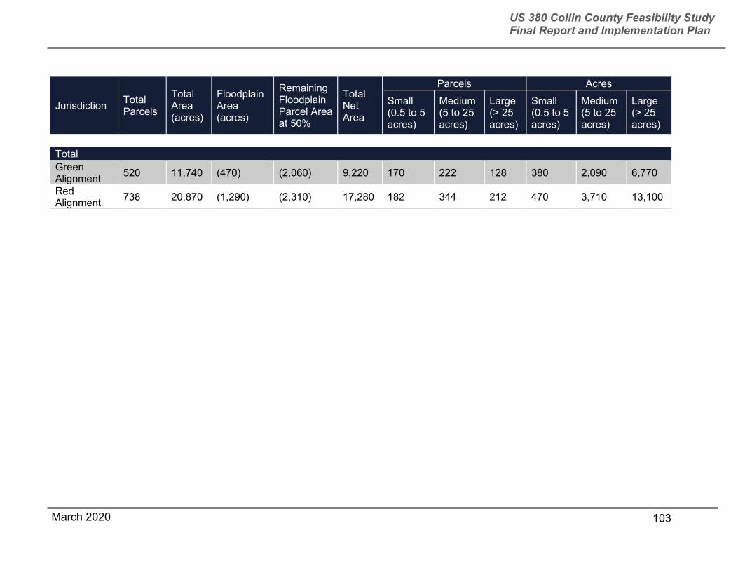
103
US 380 Collin County Feasibility Study Final Report and Implementation Plan
March 2020
Jurisdiction Total Parcels
Total Area (acres)
Floodplain Area (acres)
Remaining Floodplain Parcel Area at 50%
Total Net Area
Parcels Acres
Small (0.5 to 5 acres)
Medium (5 to 25 acres)
Large (> 25 acres)
Small (0.5 to 5 acres)
Medium (5 to 25 acres)
Large (> 25 acres)
Total
Green Alignment
520 11,740 (470) (2,060) 9,220 170 222 128 380 2,090 6,770
Red Alignment
738 20,870 (1,290) (2,310) 17,280 182 344 212 470 3,710 13,100
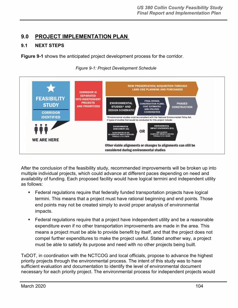
March 2020 104
US 380 Collin County Feasibility Study Final Report and Implementation Plan
9.0 PROJECT IMPLEMENTATION PLAN
9.1 NEXT STEPS Figure 9-1 shows the anticipated project development process for the corridor.
After the conclusion of the feasibility study, recommended improvements will be broken up into multiple individual projects, which could advance at different paces depending on need and availability of funding. Each proposed facility would have logical termini and independent utility as follows:
Federal regulations require that federally funded transportation projects have logical
termini. This means that a project must have rational beginning and end points. Those
end points may not be created simply to avoid proper analysis of environmental
impacts.
Federal regulations require that a project have independent utility and be a reasonable
expenditure even if no other transportation improvements are made in the area. This
means a project must be able to provide benefit by itself, and that the project does not
compel further expenditures to make the project useful. Stated another way, a project
must be able to satisfy its purpose and need with no other projects being built.
TxDOT, in coordination with the NCTCOG and local officials, propose to advance the highest priority projects through the environmental process. The intent of this study was to have sufficient evaluation and documentation to identify the level of environmental document necessary for each priority project. The environmental process for independent projects would
Figure 9-1: Project Development Schedule

March 2020 105
US 380 Collin County Feasibility Study Final Report and Implementation Plan
cover the initial near-term phased construction and would also document the need to preserve the necessary ROW to achieve the long-term need and goals.
These projects would be incorporated into the MTP, UTP, TIP, and Statewide Transportation Improvement Program (STIP), as appropriate. This action is consistent with the RTC policy FT3-008 and FT3-009, to accommodate the ultimate access-controlled transportation facility that would meet the long-term needs.
Possible Independent Project Segmentation In Figure 9-2, the feasibility study area is segmented into possible project areas for schematic design and environmental study sections.
Figure 9-2: Segmented Project Areas
Project Limits Project Priority Factors Priority Level Overall Project Priority
From Denton County Line/West of CR 26 to Coit Road
Risk of land being developed High
High Anticipated population growth High
Traffic need High
From Coit Road to Spur 399/FM 1827
Risk of land being developed High
High Anticipated population growth High
Traffic need High
Spur 399 extension - From US 380 on the north to SH 5 on the south
Risk of land being developed High High (also due in part to its connection to US 75 and SH5)
Anticipated population growth Medium
Traffic need High
From Spur 399/ FM 1827 to Lake Lavon/CR 559
Risk of land being developed Medium
Medium Anticipated population growth Medium
Traffic need Medium
Lake Lavon/CR 559 to Hunt Count Line
Risk of land being developed Low
Low Anticipated population growth Low
Traffic need Low

March 2020 106
US 380 Collin County Feasibility Study Final Report and Implementation Plan
The segments from the Denton County line to FM 1827 are rated high priority due to the pace of new developments TxDOT was advised of from the City of Frisco, Town of Prosper, and City of McKinney, and the rapidly rising cost of land. These areas also have the highest traffic volumes.
The Spur 399 extension segment is rated high because it is expected to draw traffic from US 75 and SH 5. The Spur 399/FM 1827 to Lake Lavon (most of which is near Princeton was ranked medium priority because TxDOT is already developing a project to widen the existing US 380 in this area that is expected to provide some relief to traffic.
The Lake Lavon to Hunt County line segment (most of which is in Farmersville) was ranked as low priority because no major new developments were identified for either red or green alignment areas and travel demand volumes in the segment are the lowest in the study area.
As funding is identified for an individual project, the environmental process, public involvement activities, schematic design, and any necessary environmental permitting would begin. During the environmental process and schematic design, additional agency coordination would be conducted to ensure that the project being developed complies with all state and federal laws, guidance, rules, and regulations, as appropriate.
Once the schematic design and environmental study has been completed and environmental clearance has been obtained, TxDOT would begin the ROW acquisition process, which is estimated to take approximately 24 months to complete. Although TxDOT is required to have obtained environmental clearance before purchasing ROW, it is possible for others, such as Collin County, to purchase and landbank, or preserve, right of way at-risk of development prior to a project receiving environmental clearance so it will be available in the future. Time is an important factor in land banking or purchase ROW in this rapidly developing area. Prices for land are very likely to increase in the future.
Following land banking and ROW acquisition, construction would begin and could take an additional 24 to 48 months to complete. Projects can begin at any time once funding for a specific project has been identified.
An overview estimating possible duration of future phases of project development can be found in Figure 9-3.
Figure 9-3: Estimated Duration of Project Phases
Project Phase Estimated Duration
Environmental study and schematic design
2 to 4 years* *depending on if an EA is conducted (2 to 3 years) or an EIS is conducted (2 to 4 years).
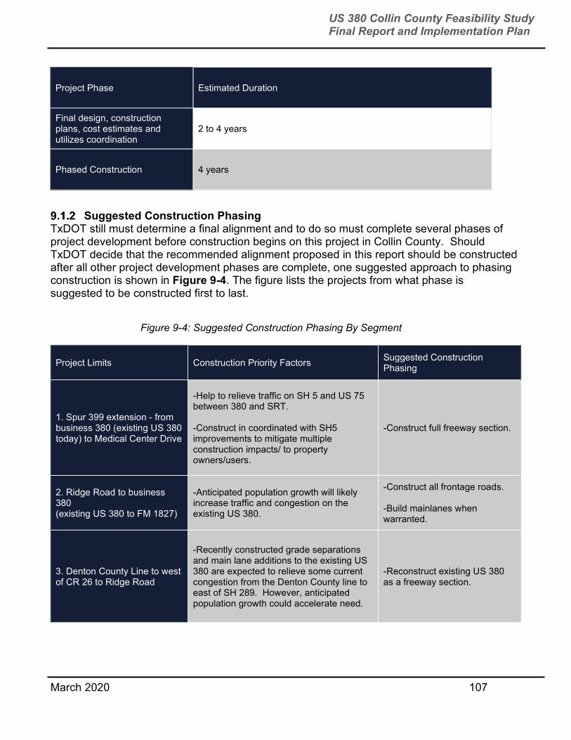
March 2020 107
US 380 Collin County Feasibility Study Final Report and Implementation Plan
Suggested Construction Phasing
TxDOT still must determine a final alignment and to do so must complete several phases of project development before construction begins on this project in Collin County. Should TxDOT decide that the recommended alignment proposed in this report should be constructed after all other project development phases are complete, one suggested approach to phasing construction is shown in Figure 9-4. The figure lists the projects from what phase is suggested to be constructed first to last.
Project Limits Construction Priority Factors Suggested Construction Phasing
1. Spur 399 extension - from business 380 (existing US 380 today) to Medical Center Drive
-Help to relieve traffic on SH 5 and US 75 between 380 and SRT. -Construct in coordinated with SH5 improvements to mitigate multiple construction impacts/ to property owners/users.
-Construct full freeway section.
2. Ridge Road to business 380 (existing US 380 to FM 1827)
-Anticipated population growth will likely increase traffic and congestion on the existing US 380.
-Construct all frontage roads. -Build mainlanes when warranted.
3. Denton County Line to west of CR 26 to Ridge Road
-Recently constructed grade separations and main lane additions to the existing US 380 are expected to relieve some current congestion from the Denton County line to east of SH 289. However, anticipated population growth could accelerate need.
-Reconstruct existing US 380 as a freeway section.
Project Phase Estimated Duration
Final design, construction plans, cost estimates and utilizes coordination
2 to 4 years
Phased Construction 4 years
Figure 9-4: Suggested Construction Phasing By Segment
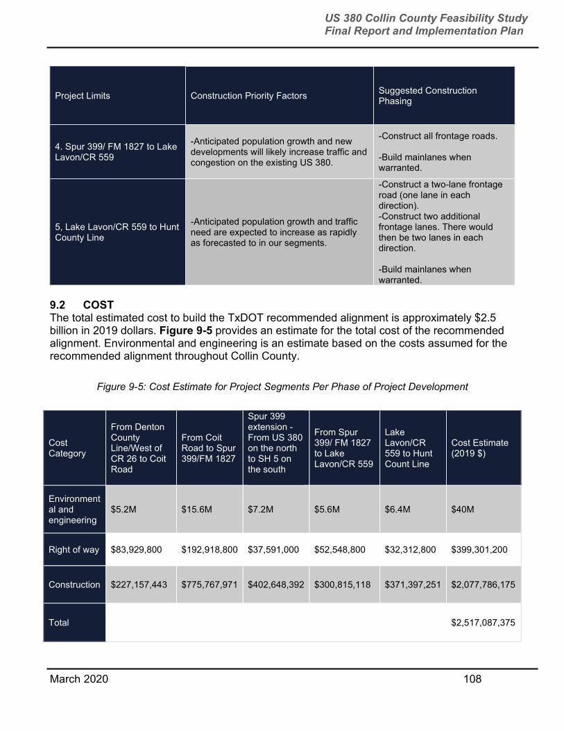
March 2020 108
US 380 Collin County Feasibility Study Final Report and Implementation Plan
Project Limits Construction Priority Factors Suggested Construction Phasing
4. Spur 399/ FM 1827 to Lake Lavon/CR 559
-Anticipated population growth and new developments will likely increase traffic and congestion on the existing US 380.
-Construct all frontage roads. -Build mainlanes when warranted.
5, Lake Lavon/CR 559 to Hunt County Line
-Anticipated population growth and traffic need are expected to increase as rapidly as forecasted to in our segments.
-Construct a two-lane frontage road (one lane in each direction). -Construct two additional frontage lanes. There would then be two lanes in each direction. -Build mainlanes when warranted.
9.2 COST The total estimated cost to build the TxDOT recommended alignment is approximately $2.5 billion in 2019 dollars. Figure 9-5 provides an estimate for the total cost of the recommended alignment. Environmental and engineering is an estimate based on the costs assumed for the recommended alignment throughout Collin County.
Figure 9-5: Cost Estimate for Project Segments Per Phase of Project Development
Cost Category
From Denton County Line/West of CR 26 to Coit Road
From Coit Road to Spur 399/FM 1827
Spur 399 extension - From US 380 on the north to SH 5 on the south
From Spur 399/ FM 1827 to Lake Lavon/CR 559
Lake Lavon/CR 559 to Hunt Count Line
Cost Estimate (2019 $)
Environmental and engineering
$5.2M $15.6M $7.2M $5.6M $6.4M $40M
Right of way $83,929,800 $192,918,800 $37,591,000 $52,548,800 $32,312,800 $399,301,200
Construction $227,157,443 $775,767,971 $402,648,392 $300,815,118 $371,397,251 $2,077,786,175
Total $2,517,087,375

March 2020 109
US 380 Collin County Feasibility Study Final Report and Implementation Plan
Right of way acquisition for this project is estimated to cost $399,301,200. It is important to note that for the yearly average from 2016-2019 that the Dallas District spent on right of way acquisition was only $84,944,854 and statewide TxDOT spent an annual average of $562,466,431. That means that right of way acquisition for the recommended alignment should it be constructed would be four times what the District spends per year on average and more than half of what is spent for the entire state in a year.
9.3 FUNDING Funding for this project could be identified from national, state, and local sources. Below are sources that have currently been identified:
Collin County – $395,761,616 in bonds funds are available from the 2018 County Bond
Program to be used for planning and landbanking. The county would like to use these
funds as part of the locals’ 10 percent match for the project’s ROW. Collin County
anticipates a bond program every five years, part of which will continue to address US
380 funding needs.
Regional/State Funding –NCTCOG, in coordination the TxDOT, has also included
$450,000,000 for construction of US 380 from the Denton County line to Hunt County
line in its Regional 10 Year Plan of Projects (2017-2028).
TxDOT’s recommended alignment is not currently included in the region’s MTP or TxDOT’s UTP but would need to be included in those documents as well as the Transportation Improvement Program (TIP). The UTP is TxDOT’s statewide 10-year plan that guides the development of transportation work across the state. Organized into 12 funding categories, with each one addressing a specific type of work, the UTP authorizes the distribution of construction dollars expected to be available over the next 10 years. The outcome of the UTP process is a list of projects TxDOT intends to develop or begin constructing over the next 10 years, as well as information on the available funding associated with those projects.
The funding categories US 380 would be eligible for would likely include categories 2, 4, and 12. The funding allocation for the 2020 UTP for these categories for projects in the Dallas Districts totals $6,818,740,000 and are as follows:
Category 2 (Metropolitan and Urban Corridors) – $3,516,260,000 for the DFW region
which includes the Dallas, Fort Worth and Paris TxDOT Districts an average around
$350 million per year for three districts.
Category 4 (Connectivity Corridors) – $1,045,130,000 for the Dallas District an average
around $104 million per year for the district.
Category 12 (Strategic Priority) – $2,257,350,000 for the Dallas District an average
around $225 million per year for the District.
However, it is important to note that there are many transportation needs in the DFW region that would need to also utilize these categories. In fact, according to NCTCOG, the region’s most current 10-year plan contains $7 billion in transportation projects that need funding in the
March 2020 110
US 380 Collin County Feasibility Study Final Report and Implementation Plan
DFW region from FY 2017-2029. The funding in UTP is allocated already to other projects, but those funds could be moved to new projects. The UTP is updated every year.
Cost estimated for the recommended alignment ($2.5 billion in 2019 dollars) is a little over the amount Dallas receives in Category 12 funding for 10 years. As of today, it appears it may take over 20 years to fund the entire recommended alignment in Collin County unless other funds are identified.
TxDOT, Collin County, and NCTCOG plan to continue to work together to identify funding as this project moves forward.
9.4 SAFETY AND SHORT-TERM/INTERIM PROJECTS TxDOT will continue to consider future improvements designed to enhance safety.
TxDOT recommends consideration of the following short-term projects, many of which would be designed to enhance safety:
Add right and left turn bays at existing intersections.
Increase length of turn bays based on current and future traffic.
Adding raised medians where possible. Additional efforts should include the following:
Work with municipalities on access management plans.
Coordinate with municipalities as they are planning, improving, or constructing other
roadways in the study area.
Recommended Future Feasibility Studies on Adjacent Corridors In an effort to improve east-west mobility in the region, TxDOT is currently conducting a similar feasibility study in Denton County. Initial conversations were held during this study for the TxDOT Paris District to consider leading a study in Hunt County. 9.5 POTENTIAL MINIMIZATION OF EFFECTS AND MITIGATION STRATEGIES During the development of alignments, both built and natural environmental factors and constraints were considered. Practicable efforts have been made in the planning process to avoid impacts to the human and natural environments. When impacts are unavoidable, steps would be taken first to minimize impacts and then to mitigate for impacts. Impacts would be evaluated during the environmental process. According to the Council on Environmental Quality regulations (40 CFR 1508.20), mitigation efforts may be defined as:
Avoiding an impact altogether.
Minimizing the impact by limiting the degree or magnitude of the action.
Rectifying the impact by repairing, rehabilitating and restoring the resource.

March 2020 111
US 380 Collin County Feasibility Study Final Report and Implementation Plan
Reducing or eliminating the impact over time by preservation and maintenance
activities.
Compensating for the impact by replacing or providing substitutes to the resource
impacted.
As each individual project moves forward through project development, alignments could be shifted to avoid future development or unanticipated impacts. Where impacts to resources require coordination and permitting, required processes would be followed with the appropriate agency. A mitigation plan would be developed in cooperation with state and federal resource agencies and would be designed to mitigate for unavoidable project impacts in accordance with applicable requirements of state and federal law.
March 2020 112
US 380 Collin County Feasibility Study Final Report and Implementation Plan
APPENDIX A LOCAL GOVERNMENT COORDINATION (CITY/COUNTY RESOLUTIONS)
Collin County
Town of Prosper
City of Frisco
City of McKinney
City of McKinney / Town of Fairview
Town of Fairview
City of Farmersville

March 2020 113
US 380 Collin County Feasibility Study Final Report and Implementation Plan
COLLIN COUNTY

March 2020 114
US 380 Collin County Feasibility Study Final Report and Implementation Plan
PROSPER

March 2020 115
US 380 Collin County Feasibility Study Final Report and Implementation Plan
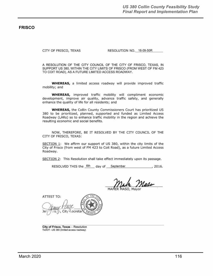
March 2020 116
US 380 Collin County Feasibility Study Final Report and Implementation Plan
FRISCO
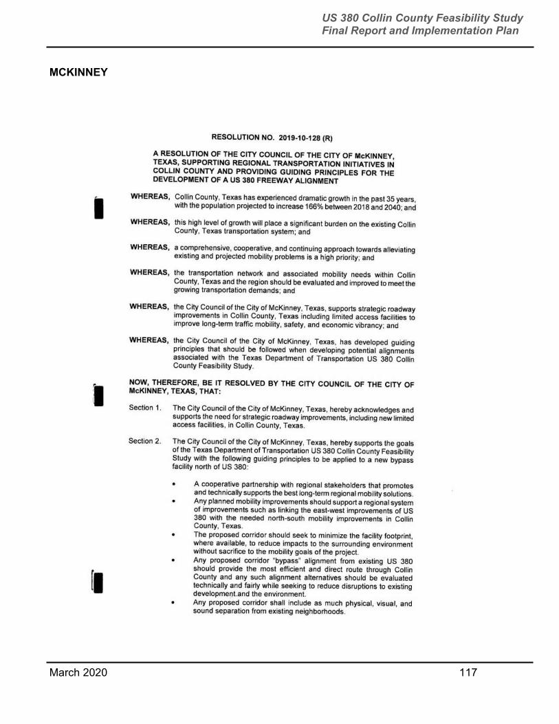
March 2020 117
US 380 Collin County Feasibility Study Final Report and Implementation Plan
MCKINNEY
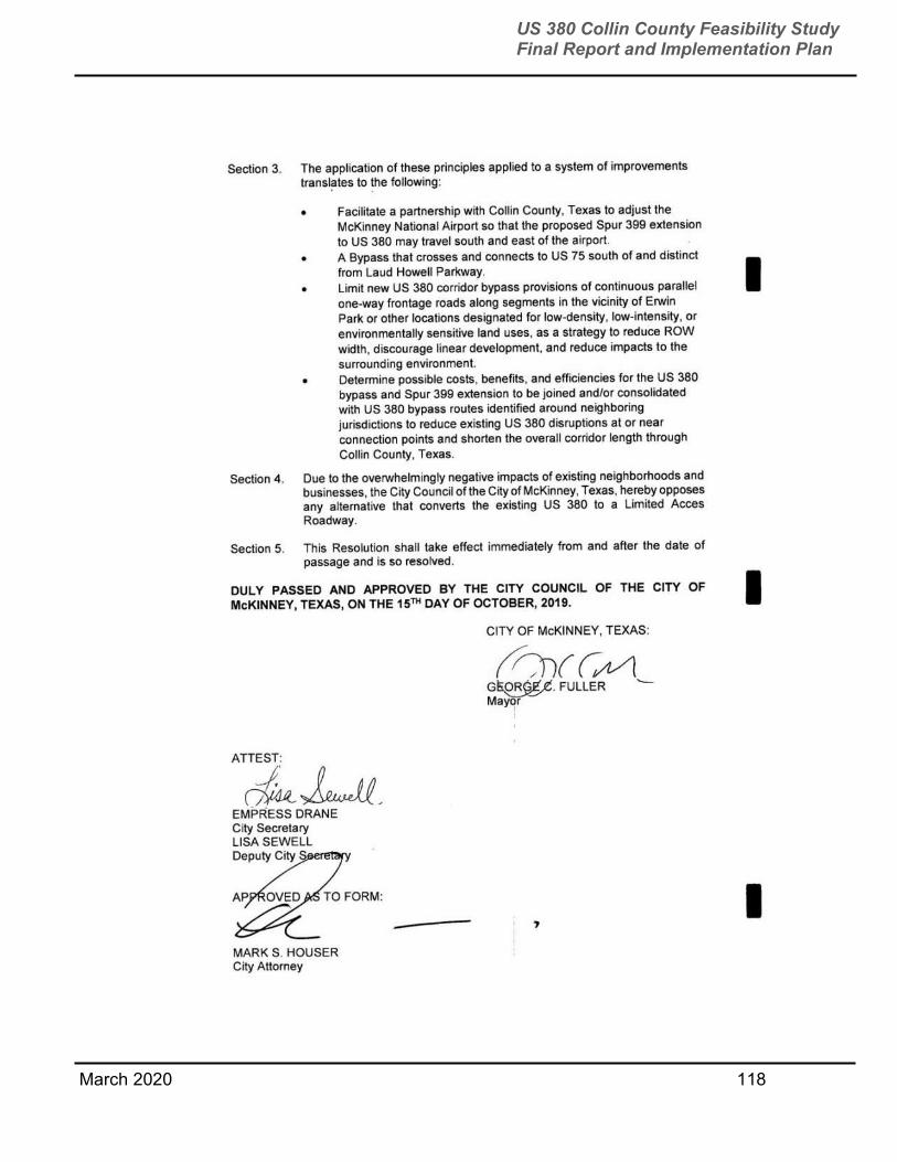
March 2020 118
US 380 Collin County Feasibility Study Final Report and Implementation Plan

March 2020 119
US 380 Collin County Feasibility Study Final Report and Implementation Plan
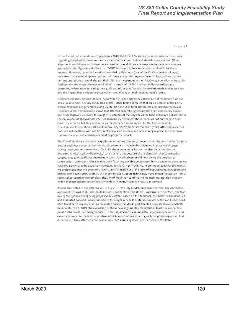
March 2020 120
US 380 Collin County Feasibility Study Final Report and Implementation Plan
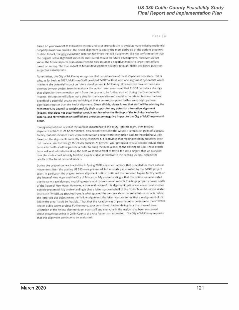
March 2020 121
US 380 Collin County Feasibility Study Final Report and Implementation Plan
March 2020 122
US 380 Collin County Feasibility Study Final Report and Implementation Plan

March 2020 123
US 380 Collin County Feasibility Study Final Report and Implementation Plan
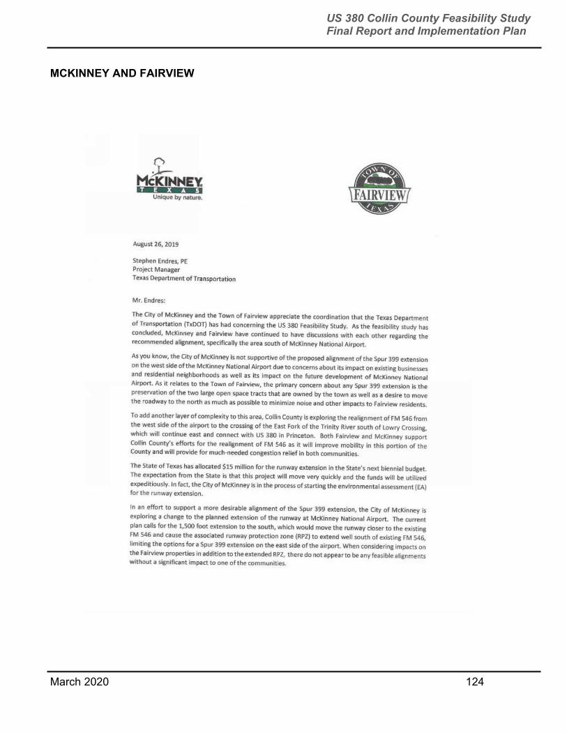
March 2020 124
US 380 Collin County Feasibility Study Final Report and Implementation Plan
MCKINNEY AND FAIRVIEW

March 2020 125
US 380 Collin County Feasibility Study Final Report and Implementation Plan

March 2020 126
US 380 Collin County Feasibility Study Final Report and Implementation Plan
FAIRVIEW
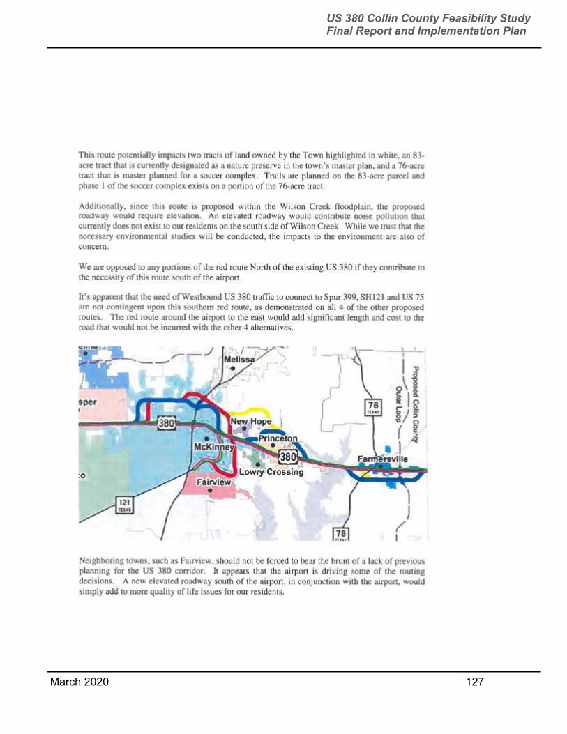
March 2020 127
US 380 Collin County Feasibility Study Final Report and Implementation Plan
March 2020 128
US 380 Collin County Feasibility Study Final Report and Implementation Plan
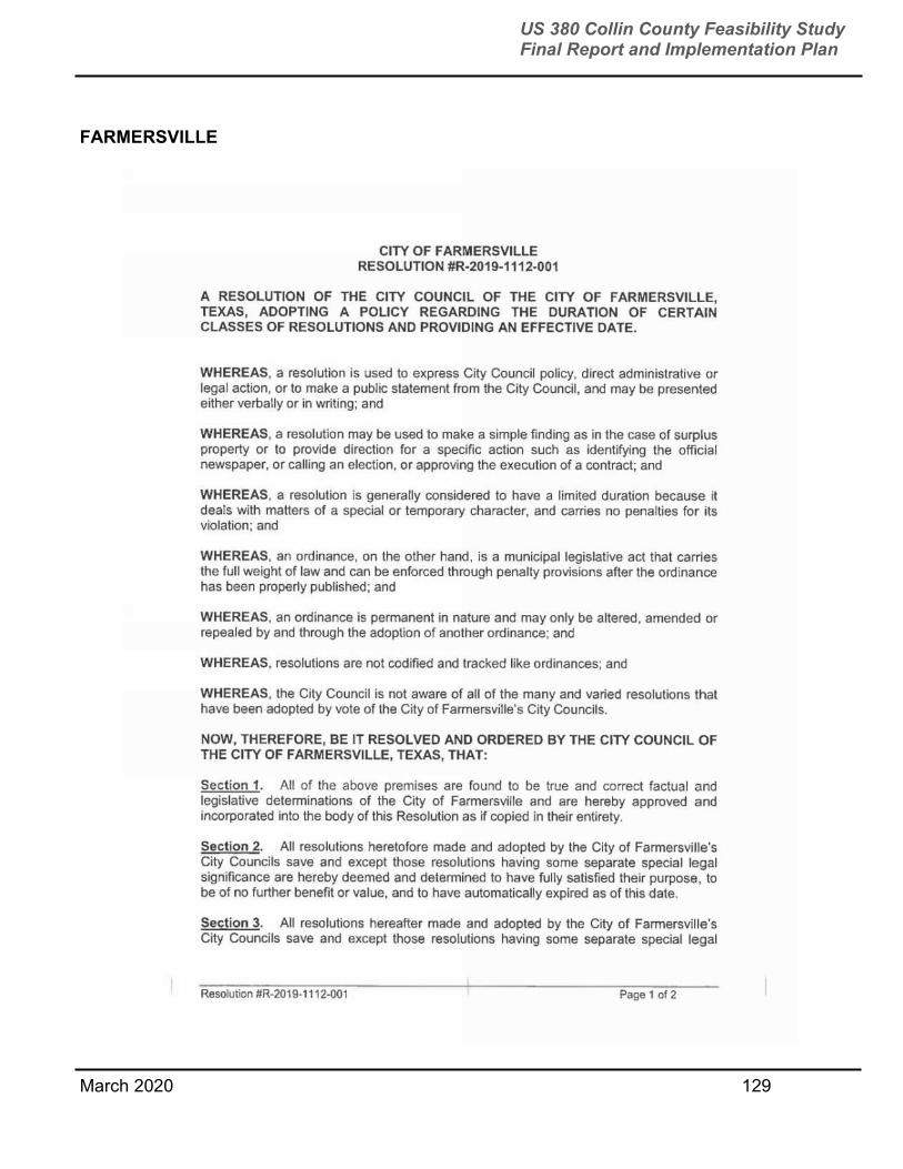
March 2020 129
US 380 Collin County Feasibility Study Final Report and Implementation Plan
FARMERSVILLE

March 2020 130
US 380 Collin County Feasibility Study Final Report and Implementation Plan
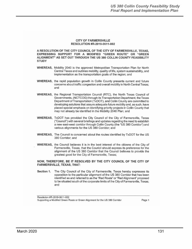
March 2020 131
US 380 Collin County Feasibility Study Final Report and Implementation Plan
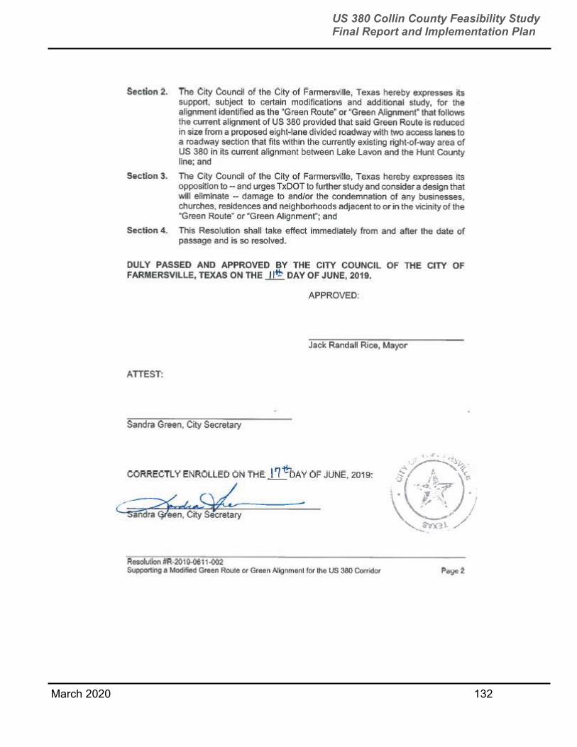
March 2020 132
US 380 Collin County Feasibility Study Final Report and Implementation Plan

March 2020 133
US 380 Collin County Feasibility Study Final Report and Implementation Plan
APPENDIX B
STAKEHOLDER MEETINGS
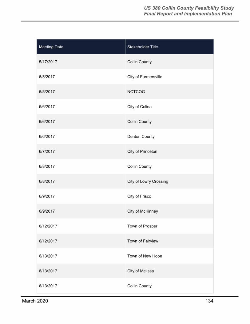
March 2020 134
US 380 Collin County Feasibility Study Final Report and Implementation Plan
Meeting Date Stakeholder Title
5/17/2017 Collin County
6/5/2017 City of Farmersville
6/5/2017 NCTCOG
6/6/2017 City of Celina
6/6/2017 Collin County
6/6/2017 Denton County
6/7/2017 City of Princeton
6/8/2017 Collin County
6/8/2017 City of Lowry Crossing
6/9/2017 City of Frisco
6/9/2017 City of McKinney
6/12/2017 Town of Prosper
6/12/2017 Town of Fairview
6/13/2017 Town of New Hope
6/13/2017 City of Melissa
6/13/2017 Collin County
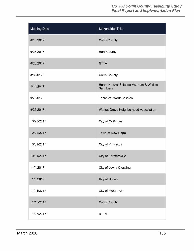
March 2020 135
US 380 Collin County Feasibility Study Final Report and Implementation Plan
Meeting Date Stakeholder Title
6/15/2017 Collin County
6/28/2017 Hunt County
6/28/2017 NTTA
8/8/2017 Collin County
8/11/2017 Heard Natural Science Museum & Wildlife Sanctuary
9/7/2017 Technical Work Session
9/25/2017 Walnut Grove Neighborhood Association
10/23/2017 City of McKinney
10/26/2017 Town of New Hope
10/31/2017 City of Princeton
10/31/2017 City of Farmersville
11/1/2017 City of Lowry Crossing
11/6/2017 City of Celina
11/14/2017 City of McKinney
11/16/2017 Collin County
11/27/2017 NTTA
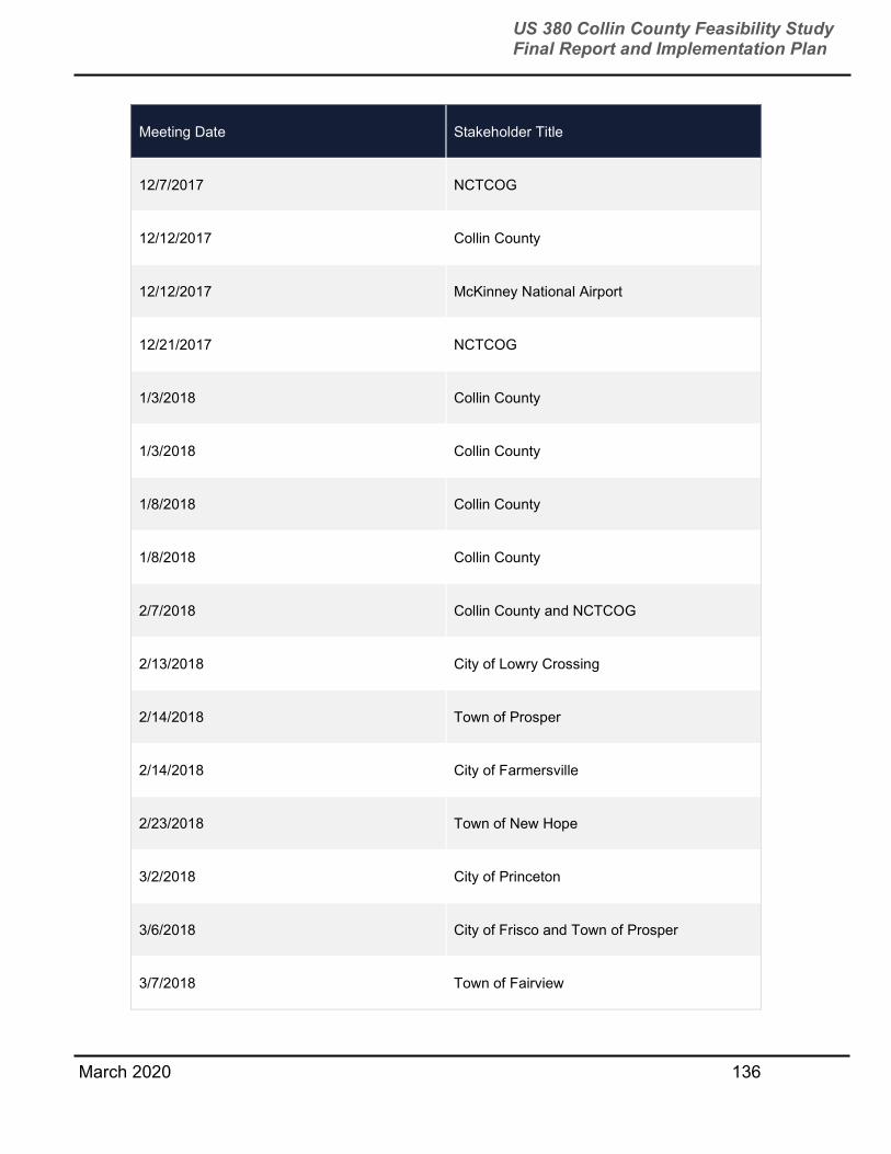
March 2020 136
US 380 Collin County Feasibility Study Final Report and Implementation Plan
Meeting Date Stakeholder Title
12/7/2017 NCTCOG
12/12/2017 Collin County
12/12/2017 McKinney National Airport
12/21/2017 NCTCOG
1/3/2018 Collin County
1/3/2018 Collin County
1/8/2018 Collin County
1/8/2018 Collin County
2/7/2018 Collin County and NCTCOG
2/13/2018 City of Lowry Crossing
2/14/2018 Town of Prosper
2/14/2018 City of Farmersville
2/23/2018 Town of New Hope
3/2/2018 City of Princeton
3/6/2018 City of Frisco and Town of Prosper
3/7/2018 Town of Fairview
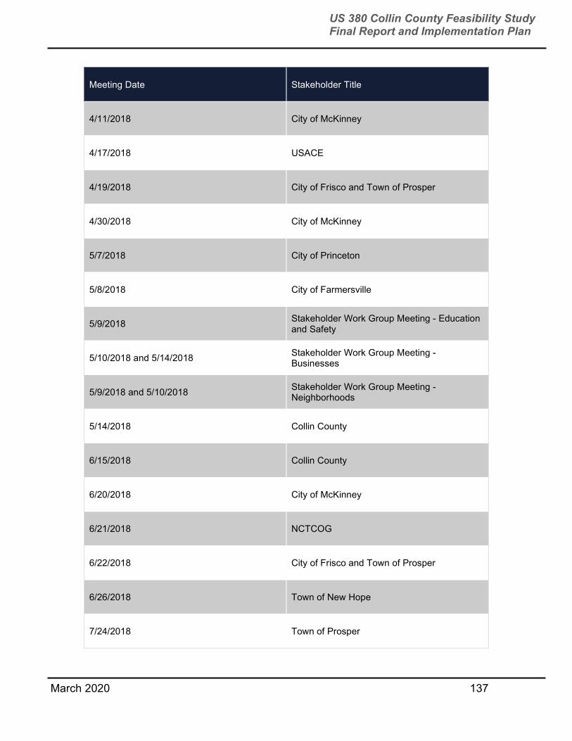
March 2020 137
US 380 Collin County Feasibility Study Final Report and Implementation Plan
Meeting Date Stakeholder Title
4/11/2018 City of McKinney
4/17/2018 USACE
4/19/2018 City of Frisco and Town of Prosper
4/30/2018 City of McKinney
5/7/2018 City of Princeton
5/8/2018 City of Farmersville
5/9/2018 Stakeholder Work Group Meeting - Education and Safety
5/10/2018 and 5/14/2018 Stakeholder Work Group Meeting - Businesses
5/9/2018 and 5/10/2018 Stakeholder Work Group Meeting - Neighborhoods
5/14/2018 Collin County
6/15/2018 Collin County
6/20/2018 City of McKinney
6/21/2018 NCTCOG
6/22/2018 City of Frisco and Town of Prosper
6/26/2018 Town of New Hope
7/24/2018 Town of Prosper

March 2020 138
US 380 Collin County Feasibility Study Final Report and Implementation Plan
Meeting Date Stakeholder Title
7/27/2018 NTMWD
8/8/2018 City of Lowry Crossing
8/8/2018 Glazer Family Farm
8/10/2018 City of McKinney, Town of Prosper, and City of Frisco
8/16/2018 Raytheon
8/20/2018 Collin County
8/28/2018 and 9/6/2018 City of Princeton
8/30/2018 City of McKinney
8/30/2018 McKinney National Airport
9/5/2018 City of Farmersville
9/6/2018 Town of Prosper
9/14/2018 Town of Prosper
10/15/2018 City of McKinney
10/14/2018 and 10/25/2018 Stakeholder Work Group - Businesses
10/17/2018 Billingsley Company
10/20/2018 Stakeholder Work Groups - Neighborhoods

March 2020 139
US 380 Collin County Feasibility Study Final Report and Implementation Plan
Meeting Date Stakeholder Title
10/22/2018 Collin County Commissioners Court
10/22/2018 Princeton City Council
10/23/2018 and 10/25/2018 Stakeholder Work Groups - HOAs
10/26/2018 Wild Land Development
11/13/2018 City of Farmersville
11/14/2018 City of Irving
12/4/2018 Raytheon
12/5/2018 Collin County, City of McKinney, and NCTCOG
12/6/2018 City of Farmersville
12/12/2018 NCTCOG
1/24/2019 NTTA
2/6/2019 NTMWD
3/1/2019 City of McKinney
3/20/2019 ManeGait
3/22/2019 Encore Wire
3/25/2019 Collin County

March 2020 140
US 380 Collin County Feasibility Study Final Report and Implementation Plan
Meeting Date Stakeholder Title
3/29/2019 LandPlan
4/5/2019 and 4/10/2019 City of McKinney
4/3/2019 City of Princeton
4/3/2019 City of Farmersville
4/4/2019 City of Lowry Crossing
4/4/2019 Town of Prosper
4/8/2019 Don Blackwood
4/11/2019 City of Frisco
4/11/2019 Town of New Hope
4/12/2019 Town of Fairview
4/12/2019 Princeton Crossroads Development
5/21/2019 Blue Mountain Equipment Inc.
5/21/2019 Heard Natural Science Museum & Wildlife Sanctuary
6/14/2019 NTMWD
6/17/2019 Encore Wire
6/20/2019 City of Irving
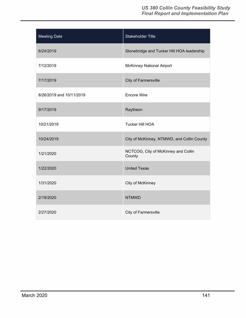
March 2020 141
US 380 Collin County Feasibility Study Final Report and Implementation Plan
Meeting Date Stakeholder Title
6/24/2019 Stonebridge and Tucker Hill HOA leadership
7/12/2019 McKinney National Airport
7/17/2019 City of Farmersville
8/26/2019 and 10/11/2019 Encore Wire
9/17/2019 Raytheon
10/21/2019 Tucker Hill HOA
10/24/2019 City of McKinney, NTMWD, and Collin County
1/21/2020 NCTCOG, City of McKinney and Collin County
1/22/2020 United Texas
1/31/2020 City of McKinney
2/19/2020 NTMWD
2/27/2020 City of Farmersville

March 2020 142
US 380 Collin County Feasibility Study Final Report and Implementation Plan
APPENDIX C
SURVEY FORMS
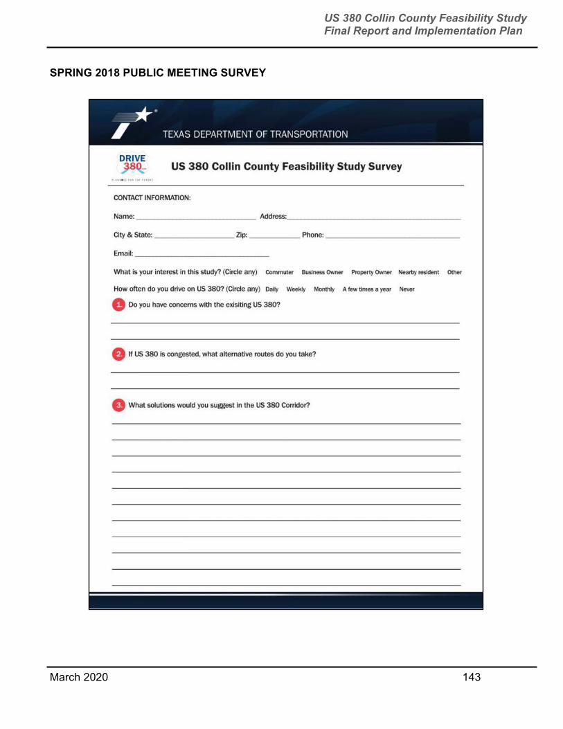
March 2020 143
US 380 Collin County Feasibility Study Final Report and Implementation Plan
SPRING 2018 PUBLIC MEETING SURVEY

March 2020 144
US 380 Collin County Feasibility Study Final Report and Implementation Plan
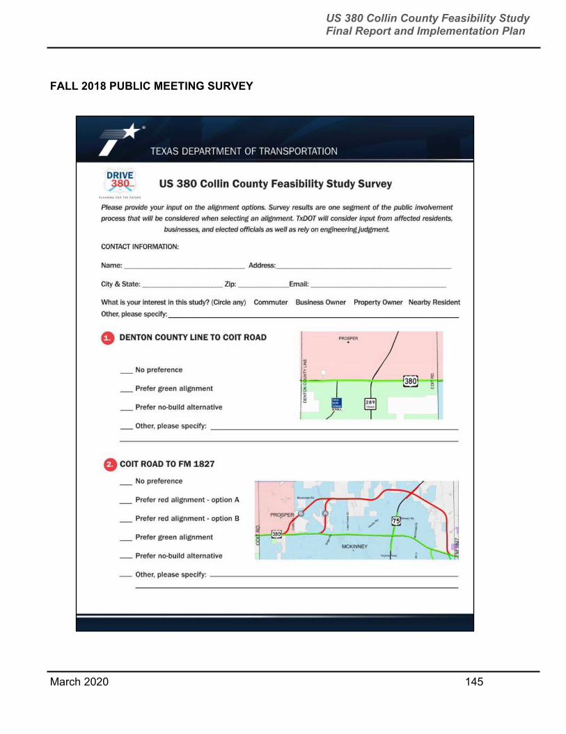
March 2020 145
US 380 Collin County Feasibility Study Final Report and Implementation Plan
FALL 2018 PUBLIC MEETING SURVEY
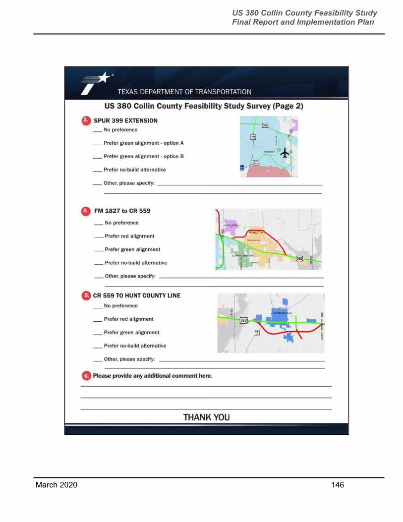
March 2020 146
US 380 Collin County Feasibility Study Final Report and Implementation Plan

March 2020 147
US 380 Collin County Feasibility Study Final Report and Implementation Plan
SPRING 2019 PUBLIC MEETING COMMENT FORM

March 2020 148
US 380 Collin County Feasibility Study Final Report and Implementation Plan
APPENDIX D
COLLIN COUNTY THOROUGHFARE PLAN MAP

149
US 380 Collin County Feasibility Study Final Report and Implementation Plan
March 2020
COLLIN COUNTY THOROUGHFARE PLAN
US 75
Dallas North
Tollway
SH 78
SH 121
US 380
Sam Rayburn Tollway
President George Bush
Turnpike


![P 6 [passive]-collin](https://static.fdocuments.us/doc/165x107/55cdeab4bb61ebd1048b46e7/p-6-passive-collin.jpg)