URBAN WATERSHED MANAGEMENT - UMass Amherst · ture Anne Whiston Spirn in The Granite Garden: “The...
17
SUSTAINABILITY, ONE STREAM AT A TIME BY RUTHERFORD H. PLATT URBAN WATERSHED MANAGEMENT “[The modern city tends] to loosen the bonds that connect [its] inhabitants with nature and to transform, eliminate, or replace its earth- bound aspects, covering the natural site with an artificial environment that enhances the dominance of man and encourages an illusion of complete independence from nature. . . . The blind forces of urbanization, flowing along the lines of least resistance, show no aptitude for creating an urban and industrial pattern that will be self-sustaining, and self-renewing.” 1 © ROYALTY FREE—CORBIS
-
Upload
nguyenduong -
Category
Documents
-
view
216 -
download
0
Transcript of URBAN WATERSHED MANAGEMENT - UMass Amherst · ture Anne Whiston Spirn in The Granite Garden: “The...

SUSTAINABILITY, ONE STREAM AT A TIME
BY RUTHERFORD H. PLATT
URBAN WATERSHED MANAGEMENT
“[The modern city tends] to loosen the bonds
that connect [its] inhabitants with nature and
to transform, eliminate, or replace its earth-
bound aspects, covering the natural site with
an artificial environment that enhances the
dominance of man and encourages an illusion
of complete independence from nature. . . .
The blind forces of urbanization, flowing along
the lines of least resistance, show no aptitude
for creating an urban and industrial pattern
that will be self-sustaining, and self-renewing.” 1
© R
OYA
LTY
FR
EE
—C
OR
BIS

© J
OH
N M
. RO
BE
RTS
—C
OR
BIS
© F
RA
NZ
MA
RC
FR
EI—
CO
RB
IS
This article was published in the May 2006 issue of Environment. Volume 48, Number 4, pages 26–42. © Heldref Publications, 2006. http://www.heldref.org/env.php
28 ENVIRONMENT VOLUME 48 NUMBER 4
The prescient Lewis Mumford wrote the words that appear on this article’s opening page (page 26) a half century ago
in an essay in Man’s Role in Changing the Face of the Earth. Today they are no less relevant and indeed serve as a tocsin warning against the illusion that cities and nature are mutually exclusive realms. This “human/nature apartheid,” accord-ing to University of British Columbia ecological economist William E. Rees, is a “legacy of the Enlightenment in western culture . . . that sees the human enterprise as somehow separate from and above the natural world.”2 That view-point has been reinforced to the present time by mainstream ecologists who have long shunned cities as wastelands and by museum exhibits, television documenta-ries, and popular magazines that portray “nature” in oceans, coral reefs, rainfor-ests, high mountains, and polar regions, but seldom where people are present in large numbers. Today, “nature” is being rediscovered in many forms within urban places––vacant lots, cemeteries, surviv-ing patches of native woods, prairies, or wetlands, signature trees, and small urban streams and watersheds.
With the benefit of inputs from many disciplines, the land use and society learn-ing process is beginning to dispel the city/nature dichotomy; public perceptions and policies are starting to acknowledge that the laws of nature are not repealed inside city limits.3 Urbanization is increasingly recognized as a disturbing agent that modifies but does not erase its physi-cal and natural setting. Conversely, the greater the degree to which that setting is reflected in society’s land use practices, the safer, healthier, and more “sustain-able” the resulting urban communities are likely to be.
An early stimulus to this new percep-tion was the discovery by geographer Gilbert F. White and his colleagues in the 1960s that intervention to control floods (through, for example, dams, levees, and seawalls) may actually increase average
annual flood losses. Such flood control measures, they argued, tend to attract new development that faces catastrophic loss when the project fails, whereas if the floodplain is left unprotected, develop-ers are unlikely to build in flood-prone
areas.4 As communicated to Congress by the Task Force on Federal Flood Con-trol,5 this insight helped stimulate public policies to encourage “wise use” of flood-plains, seeking to reconcile human and natural processes in riverine and coastal flood hazard areas.
A second stimulus emerged from the landscape design field, starting with University of Pennsylvania profes-sor Ian McHarg’s 1968 classic Design with Nature, which called for stronger reflection of physical and ecological site characteristics into development plans. McHarg’s work was popularized to a broader audience by urbanist writer Wil-liam H. Whyte in The Last Landscape.6 While McHarg and Whyte chiefly focused on new “greenfield” development at the
project scale, the “design with nature” axiom was broadened to a regional scale by MIT professor of landscape architec-ture Anne Whiston Spirn in The Granite Garden: “The city, suburbs, and the coun-tryside must be viewed as a single, evolv-
ing system within nature, as must every individual park and building within that larger whole. . . Nature in the city must be cultivated, like a garden, rather than ignored or subdued.”7
A third stimulus arose from the fledg-ling subfield of urban ecology in the 1990s in the notion of “ecological servic-es,” namely benefits of nature to human society (rural or urban) in such forms as water purification, flood storage, aquifer recharge, pollution abatement, soil forma-tion, moderation of micro-climate, and carbon sequestration. As these free eco-logical services are lost to urbanization, costly technological substitutes may be required, including flood control, sewage and water treatment, air conditioning, and artificial fertilizers.8
© A
LAN
SC
HE
IN P
HO
TOG
RA
PH
Y—C
OR
BIS
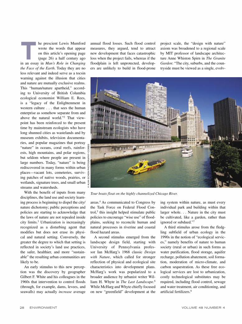
Tour boats float on the highly channelized Chicago River.

MAY 2006 ENVIRONMENT 29
Such resource-intensive substitutes for lost ecological services, however, are unsustainable even for wealthy societ-ies. Relying on this strategy to offset the ecological effects of global urbanization is implausible. As the urban proportion of world population grows from about 50 percent today to a projected 60 percent in less than a generation, 80 million new urban dwellers must be accommodat-ed annually—equivalent to building ten new megacities each year.9 Overcoming “human/nature apartheid” is thus criti-cal to the search for sustainability in an increasingly human-dominated world.
Urban Watersheds as Sustainability Test Sites
As stepping-stones to a more sustain-able planet, the National Research Coun-cil Board on Sustainable Development in its report Our Common Journey: Transi-tion Toward Sustainability called for stud-ies of regional and local experience that may provide salutary lessons for broader application:
The quest for sustainability at the regional scale is rich in the variety of institutions, values, and kinds of environmental and social systems it engages. . . . Moreover . . . many of the greatest challenges fac-ing a sustainability transition occur at the regional scale. . . . In practice, this can mean systems as small as watersheds.10
Indeed, an important harbinger of the hypothetical “transition to sustainability” may be identified in the dozens (and possibly hundreds) of small urban water-sheds in the United States and around the world that today are the focus of mul-tifarious “restoration” strategies under complex institutional arrangements. The term “urban watersheds” here refers to drainage units entirely or substantially within metropolitan regions, not major rivers that flow through or past cities like the Hudson at New York or the Mis-
sissippi at St. Louis and New Orleans. Under the U.S. Geological Survey four-tier watershed classification system,11 the lowest category (“Cataloguing Units”) is the upper level of local drainage net-works at the urban-metropolitan scale. The greatest percentage of stream miles impacted by urbanization comprise dense networks of local streams, creeks, brooks, runs, kills, and bayous––the first- and second-order streams of the widely used Strahler classification system.12 Although modest in drainage area and average flow, local watersheds typically contain a com-plex array of hydrological and ecological elements, including headwaters, channels, banks, floodplains, lakes and ponds, wet-lands, aquatic and riparian biotic habitats, aquifers, and coastal estuaries.
Cities and local drainage networks are historically interdependent. Urban settle-ments tended to locate where streams like the Chicago River, Boston’s Charles River, and Houston’s Buffalo Bayou linked hinterland settlements with har-bors or larger rivers. Even nonnavigable watercourses could be used as sources of edible fish, water supply, and water power as well as for waste sinks. Over time, many urban streams were altered hydraulically, chemically, and biologi-cally through navigation and flood control projects, wetland dredge-and-fill activi-ties, water withdrawals, waste discharges, and stream bank stabilization. Portions of most urban streams were ecologically degraded by pollution, low stream flow, channelization, or burial in tunnels—like the Park River in Hartford, Connecticut, which flows in a tunnel under the down-town area, forgotten by the city it origi-nally nurtured (see the box on page 30).
About 40 percent of stream miles of the nation’s waters assessed under the federal Clean Water Act (including most urban waterways) are categorized as “impaired.”13 From a strict perspective of water as a natural resource, “impairment” relates to the inability of such streams to serve as sources of drinking water or to support other designated uses such
as fishing or swimming. In other terms, impairment represents a loss of ecological services: Such streams are less able (or unable) to reduce flood flows, trap and fil-ter pollutants, recycle nutrients, recharge groundwater, nurture biotic habitats, offer recreational opportunities, or serve as scenic amenities.14 Downstream commu-nities often are forced to offset the loss of ecological services––due to land and water use activities in upstream jurisdic-tions––through costly technological sub-stitutes such as flood control projects and water and sewage treatment plants.
Like larger river basins, urban water-sheds must be viewed as integrated physi-cal systems whose proper functioning depends upon the interplay of hydrolog-ic, chemical, and ecological elements.15 Negative impacts from urbanization accumulate within watersheds as small tributary streams contribute their higher peak flows, lower base flows, and heavier pollutant and sediment loads to higher-order waterways downstream. Further-more, metropolitan area watersheds tend to be more heavily urbanized the farther one goes downstream. Thus, as stream conditions cumulatively worsen in the downstream direction, so too does the size of the affected public and the total-ity of economic and social costs due to such impairment.
Metropolitan watersheds are politi-cally fragmented: Streams cross politi-cal boundaries and sometimes serve as boundaries between municipalities, coun-ties, or even states.16 Furthermore, local watersheds encompass areas of great social and economic diversity. Regional streams—such as Wisconsin’s Milwaukee River; the Anacostia River in Maryland and Washington, DC; and Buffalo Bayou in the Houston area—typically rise in rural areas or exurbs then flow through progressively older suburbs, poor inner city neighborhoods, and finally through (or under) their respective downtown business districts to their mouths. Water-shed-scale improvement efforts thus theo-retically may transcend the political and

30 ENVIRONMENT VOLUME 48 NUMBER 4
economic stratification of the larger met-ropolitan region.
Promoting public awareness of and involvement in rehabilitating urban streams and watersheds may foster a sense of place and community, as Michael McGinnis, director of the University of California Santa Barbara’s Ocean and Coastal Policy Center writes, “[P]articular watersheds are significant to people because of distinct human activities that
take place within them. Also within par-ticular watersheds often there are deep symbolic and spiritual attachments to places, landscapes, and regions.”17
Even long-neglected urban waterways like the Chicago River may evolve from eyesores to local amenities with improved water quality, public access, and resulting higher property values.18
Beginning with the Federal Water Resources Planning Act of 1964, the ear-
lier practice of “river basin development” through engineered projects has gradually evolved into “water resource manage-ment” involving a broader range of goals, means, and stakeholders at the watershed scale (see Table 1 on page 31).19 This evo-lution involves two critical new perspec-tives: Ecosystem management is becom-ing the dominant paradigm for resource managers, and the renegotiation of public and private responsibilities is leading to “decentralized experiments in collabora-tive management that embrace increased citizen involvement.”20
Consistent with the second perspective, urban watershed management is increas-ingly viewed by environmental policy spe-cialists as a potential laboratory for testing new forms of public-private collabora-tion. Complex watershed partnerships and institutional flexibility are necessary to overcome the inherent balkanization of metropolitan-area watersheds as well as to include diverse stakeholders and interest groups.21 Florida State University politi-cal scientist Mark Lubell and colleagues describe watershed partnerships as “col-lective action institutions” that “encour-age cooperation between local actors with conflicting interests, divergent geographic bases, and overlapping administrative interests.”22 Debate over the goals and means of stream restoration is inevitable.23
As compared with past engineering-based approaches, contemporary watershed man-agement must reflect “the diverse values of society” with all the uncertainties, delays, and transaction costs that entails.24
Indeed, the plethora of legal mandates and incentives that have arisen since 1970 are a mixed blessing: They provide new tools and funding for creative watershed programs, but they also may exacerbate conflict among stakeholders, for example, between private property owners and pub-lic recreation interests, between develop-ers and wetlands managers, or between users of noisy water craft and those who prefer quieter pastimes.
The relationship between federal and nonfederal interests since the 1970s has
There are numerous urban impacts on local watersheds and aquatic resources, including the following:
• Flood hazards in metropolitan-scale watersheds are intensified by increasing flashiness (the tendency to flood) and magnitude of peak discharge from storm events due to the spread of impervious land cover, grading the land surface, removal of vegetation and natu-ral storage, and proliferation of artificial drainage networks.1 This renders earlier calculation of the 1 percent chance (“100-year”) floodplain obsolete, and development conforming to National Flood Insurance Program standards when built incurs a rising risk of flood-ing over time.2
• Increased impervious cover (IC) in urban watersheds alters stream hydrol-ogy and degrades stream habitat, water quality, and aquatic diversity.3
• Rapid fluctuation in streamflow due to increased stream flashiness or deliberate intervention (for example, for hydropower or river rafting) accelerate bank erosion and downstream sedi-mentation. Siltation has been deemed the “number one threat to the nation’s streams” by the U.S. Environmental Protection Agency.4
• Urban streams are contaminated by point sources—such as combined sewer overflows, sanitary sewer overflows, and industrial discharges––and nonpoint sources such as failing septic systems and storm runoff. Farm and landscape fertilizers contribute phosphates and nitrogen to local drainage systems, caus-
ing algal blooms and reduced dissolved oxygen downstream, which leads to fish kills. Public water supplies require mon-itoring for pathogens, fecal coliform, viruses, giardia, and cryptospiridia.5 Low impact development and smart growth techniques may help to reduce flows to storm sewers.6
• Public access to and enjoyment of urban surface waters is widely impaired by physical obstructions such as flood walls and riprap, by private owner-ship of stream banks, and by discarded objects such as junk cars.
1. Center for Watershed Protection (CWP), Unified Stream Assessment: A User’s Manual, Elli-cott City, MD: CWP, 2004), chapter 3.
2. J. A. Kusler and L. Larson, “Beyond the Ark: A New Approach to U. S. Floodplain Man-agement,” Environment 35, no. 5 (June 1993): 6–11, 31–34.
3. CWP (note 1 above, page 23) estimates that watersheds with 10–25 percent impervious cover (IC) “often exhibit the greatest restoration poten-tial” with more limited potential for those with 25-60 percent IC. For watersheds exceeding 60 per-cent IC, “the prospects to restore aquatic diversity are extremely limited, although it may be possible to achieve significant pollutant reductions.”
4. See U.S. Environmental Protection Agency, Watersheds and Nonpoint Source Section, http://www.epa.gov/region4/water/watersheds.
5. R. H. Platt, P. K. Barten, and M. J. Pfeffer, “A Full, Clean Glass: Managing New York City’s Watersheds,” Environment 42, no. 5 (June 2000): 8–19.
6. T. Daniels, When City and Country Collide: Managing Growth in the Metropolitan Fringe (Washington, DC: Island Press, 1999); and P. Berke et al., “Greening Development to Protect Watersheds,” Journal of the American Planning Association 69, no. 4 (2003): 397–413.
URBAN IMPACTS

MAY 2006 ENVIRONMENT 31
become less peremptory as the latter have chafed under (often unfunded) federal mandates. For watershed partnerships to be effective, federal primacy must be
relaxed: According to William Goldfarb, professor of environmental law at Rutgers University, “Many commentators have agreed that . . . watershed management
should stress negotiation and consent rather than command and control regula-tion.”25 However, federal and state fund-ing and regulations may still be needed to achieve much at the local level.26
In summary, urban watersheds are complex geographic mosaics of physical, ecological, political, and socioeconomic diversity. Urbanization alters natural flow regimes, water quality, biological health, and sociocultural values with consequent loss of ecological services. In place of narrow technical responses to specific problems like flooding or water pol-lution, holistic watershed management today seeks to integrate a broad range of goals, means, and participants through ad hoc watershed partnerships. Efforts of watershed partnerships include various forms of stream and wetland restora-tion, environmental education, and other measures listed in Table 1. Ideally, such efforts may enhance both the physical/biological health of urban streams and the attachment of watershed residents to their local streams—and thus to the larger nat-ural world and to each other. In short, as suggested by the authors of Our Common Journey, local and regional watersheds are ideal geographic units within which to test new institutional, technical, and cultural strategies for achieving a measure of sustainability.
Sampling Urban Watershed Management Experience
A recently completed study at the Uni-versity of Massachusetts Amherst reviewed experiences in several urban watersheds under a grant from the National Science Foundation.27 That study postulated that many urban communities are beginning to adjust to biophysical constraints rather than ignoring them or overcoming them technologically: “The leading edge of this process of urban greening is most apparent in new attitudes, perceptions, policies, and approaches to the management of urban aquatic resources, particularly stream cor-
Table 1. Urban watershed management goals and strategies
Goals Strategies
Non–site specific Site-specific
Water quality improvement
Nonpoint source controls:Septic system upgradeSSO control/sewer repairMaintain minimum flowsLow-impact developmentLitter cleanupMonitoring
Point source controls:NPDES discharge permits CSO reduction (LTCPs)Green stormwater BMPsRiparian bioengineeringBrownfield remediationReforestation/aquifer recharge
Flood hazard reduction
Flood modeling and mappingFloodplain regulationsWarning/evacuation plansFloodproofingAutomated rainfall/ streamflow monitoringPublic information
Remove channel obstaclesRestore natural flow regimeFloodprone property buyout Wetland restorationGreen stormwater BMPs(such as rain gardens, green roofs, and porous paving)
Aquatic habitat/fisheries restoration
Maintain minimum flowsIncrease dissolved oxygenReduce toxics, organics, metals, etc.Reduce bank erosionand sedimentationLitter clean-upInvasives control (such as the zebra mussel)Fish restocking
Dam removalStream daylightingRemove shoreline armoringRestore streamflow regime(pool/riffle/meanders)Riparian buffer restoration (bioengineering andreforestation)Invasive plant removal/Planting of native speciesWetlands restorationFish passageways on dams
Public use and awareness
Watershed public events Reduce health hazardsImprove visibility of streamPublic information (such as signage, websites, and newsletters)
Urban waterfront renewalGreenways/bikewaysPublic recreation sitesBoat launch rampsEnvironmental education sites
NOTE: BMPs: best management practices; CSO: combined sewer overflow; LTCP: long term control plan; NPDES: National Pollution Discharge Elimination System; SSO: sanitary sewer overflow. Classification as “site-specific” and “non–site specific” is the subjective judgment of the writer; for some purposes, these categories may be blurred.
SOURCE: R. H. Platt, 2006.
32 ENVIRONMENT VOLUME 48 NUMBER 4
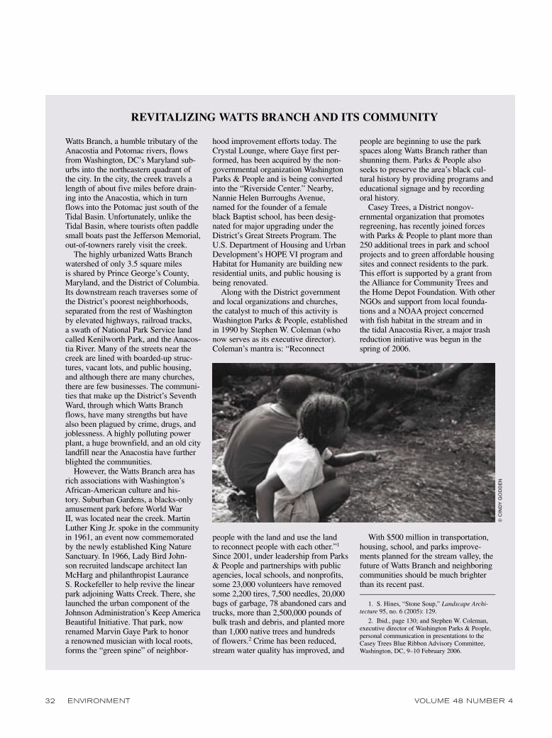
Watts Branch, a humble tributary of the Anacostia and Potomac rivers, flows from Washington, DC’s Maryland sub-urbs into the northeastern quadrant of the city. In the city, the creek travels a length of about five miles before drain-ing into the Anacostia, which in turn flows into the Potomac just south of the Tidal Basin. Unfortunately, unlike the Tidal Basin, where tourists often paddle small boats past the Jefferson Memorial, out-of-towners rarely visit the creek.
The highly urbanized Watts Branch watershed of only 3.5 square miles is shared by Prince George’s County, Maryland, and the District of Columbia. Its downstream reach traverses some of the District’s poorest neighborhoods, separated from the rest of Washington by elevated highways, railroad tracks, a swath of National Park Service land called Kenilworth Park, and the Anacos-tia River. Many of the streets near the creek are lined with boarded-up struc-tures, vacant lots, and public housing, and although there are many churches, there are few businesses. The communi-ties that make up the District’s Seventh Ward, through which Watts Branch flows, have many strengths but have also been plagued by crime, drugs, and joblessness. A highly polluting power plant, a huge brownfield, and an old city landfill near the Anacostia have further blighted the communities.
However, the Watts Branch area has rich associations with Washington’s African-American culture and his-tory. Suburban Gardens, a blacks-only amusement park before World War II, was located near the creek. Martin Luther King Jr. spoke in the community in 1961, an event now commemorated by the newly established King Nature Sanctuary. In 1966, Lady Bird John-son recruited landscape architect Ian McHarg and philanthropist Laurance S. Rockefeller to help revive the linear park adjoining Watts Creek. There, she launched the urban component of the Johnson Administration’s Keep America Beautiful Initiative. That park, now renamed Marvin Gaye Park to honor a renowned musician with local roots, forms the “green spine” of neighbor-
hood improvement efforts today. The Crystal Lounge, where Gaye first per-formed, has been acquired by the non-governmental organization Washington Parks & People and is being converted into the “Riverside Center.” Nearby, Nannie Helen Burroughs Avenue, named for the founder of a female black Baptist school, has been desig-nated for major upgrading under the District’s Great Streets Program. The U.S. Department of Housing and Urban Development’s HOPE VI program and Habitat for Humanity are building new residential units, and public housing is being renovated.
Along with the District government and local organizations and churches, the catalyst to much of this activity is Washington Parks & People, established in 1990 by Stephen W. Coleman (who now serves as its executive director). Coleman’s mantra is: “Reconnect
people with the land and use the land to reconnect people with each other.”1 Since 2001, under leadership from Parks & People and partnerships with public agencies, local schools, and nonprofits, some 23,000 volunteers have removed some 2,200 tires, 7,500 needles, 20,000 bags of garbage, 78 abandoned cars and trucks, more than 2,500,000 pounds of bulk trash and debris, and planted more than 1,000 native trees and hundreds of flowers.2 Crime has been reduced, stream water quality has improved, and
people are beginning to use the park spaces along Watts Branch rather than shunning them. Parks & People also seeks to preserve the area’s black cul-tural history by providing programs and educational signage and by recording oral history.
Casey Trees, a District nongov-ernmental organization that promotes regreening, has recently joined forces with Parks & People to plant more than 250 additional trees in park and school projects and to green affordable housing sites and connect residents to the park. This effort is supported by a grant from the Alliance for Community Trees and the Home Depot Foundation. With other NGOs and support from local founda-tions and a NOAA project concerned with fish habitat in the stream and in the tidal Anacostia River, a major trash reduction initiative was begun in the spring of 2006.
With $500 million in transportation, housing, school, and parks improve-ments planned for the stream valley, the future of Watts Branch and neighboring communities should be much brighter than its recent past.
1. S. Hines, “Stone Soup,” Landscape Archi-tecture 95, no. 6 (2005): 129.
2. Ibid., page 130; and Stephen W. Coleman, executive director of Washington Parks & People, personal communication in presentations to the Casey Trees Blue Ribbon Advisory Committee, Washington, DC, 9–10 February 2006.
REVITALIZING WATTS BRANCH AND ITS COMMUNITY
© C
IND
Y G
OD
DE
N
MAY 2006 ENVIRONMENT 33
ridors, wetlands, and coastal estuaries.”28 Major questions that guided the research at the outset were:
• How are urban watersheds organized?• What is the role of science and sci-
entists in the formulation of watershed programs?
• What watershed management strate-gies are used?
• How do federal/state laws influence management of the watershed?
To pursue these and related questions, researchers conducted a series of recon-naissance-level case studies of balancing environmental, social, and economic goals at the urban watershed scale. Urban water-sheds studied included the Charles River (Boston area), Buffalo Bayou (Houston), the Milwaukee River (Wisconsin), the Anacostia River (Maryland and the Dis-trict of Columbia), Johnson Creek (Port-land, Oregon), the Little Miami River (near Dayton, Ohio), and Laurel Creek (Waterloo, Ontario). Other watersheds investigated through published literature, contacts with local activists, or student research include the Park River in Hart-ford, Connecticut; Nine Mile Run in Pittsburgh, Pennsylvania; Fall Kill Creek in Poughkeepsie, New York; Salt Creek in the western suburbs of Chicago; the Santa Ana in Southern California; the Rouge River in Detroit; and Watts Branch in the District of Columbia (see the box on the facing page). Summaries of the Charles River, Buffalo Bayou, and Johnson Creek research follow.29
Boston’s Charles River
The 308–square mile Charles River watershed in eastern Massachusetts is the quintessential metropolitan stream (see Figure 1 on page page 34). Like the Bos-ton Marathon, the Charles extends from Boston’s far western suburbs to the heart of the city; unlike the race, it takes a less direct route along the path of least resis-tance, winding 80 river miles and drop-ping 352 feet to reach its mouth at Boston Harbor. The watershed, with a population
of about 900,000 people, lies entirely in Massachusetts but is fragmented among 35 towns and cities, 27 of them entirely drained by the Charles. From its headwa-ters in the high-technology exurbs near Boston’s I-495 outer beltway, the river drops over a series of old milldams and then enters a long reach of gentle terrain and grassy meadowlands. More than 10 percent of the watershed (about 20,000 acres) consists of freshwater wetlands. Next, the river carves its way among glacial moraines and drumlins. Below the former mills of Newton, Waltham, and Watertown, the Charles flows into its final and best-known reach: the Charles River Basin, a scenic impoundment between Boston and Cambridge lined with parks and in good weather plied by “Tech Din-ghies” and other recreational craft.
Historically, the Charles played a key role in the founding and growth of Bos-ton. Unlike the earlier-settled Plymouth Colony, which lacked water access to the interior, the navigable lower reaches of the Charles enabled colonial Boston to serve as port and marketplace for a flourish-ing hinterland of inland settlements. Mill sites appropriating the modest gradient of the Charles generated economic and population growth in the Boston region during the nineteenth century. After the Civil War, Boston filled the wetlands of the lower Charles to create the planned new district of Back Bay. Adjoining that, the river was proposed by civic leaders and landscape architects to be converted into a recreational water park. That was realized with the impoundment of the river by a dam in 1910 and the construc-tion of Storrow Drive and the Esplanade in the 1930s. The latter, a much-admired riverside park, is the venue of outdoor concerts by the Boston Pops, including its traditional Fourth of July performance of the 1812 Overture accompanied by can-non and fireworks.
By the 1960s, however, the Charles was an ongoing environmental disaster: heav-ily polluted by industrial and sewage dis-charges, degraded as a habitat, repellant
to people seeking recreation, and a rising flood threat to low-lying areas. Flood-ing was the most immediate issue in the 1960s, as suburban development covered the watershed with impervious land cover and structures impinged on floodplains. After a series of floods in the 1950s and 1960s, local and state political leaders summoned the Army Corps of Engineers to design a flood control project for the Charles. The Charles River Watershed Association (CRWA) was established in 1965, just in time to challenge the Corps’s conventional concrete-based flood con-trol strategy.
Fortuitously, the New England regional headquarters of the Corps is in Waltham, Massachusetts, within the Charles water-shed. Intense communication between the Corps and CRWA produced a novel plan in 1970 to reduce flooding in the water-shed through a three-part strategy: acqui-sition and protection of several thousand acres of remaining wetlands for “natural valley storage”; encouragement of flood-plain and wetland regulation by water-shed towns and cities; and construction of a new dam at the river’s mouth to allevi-ate overflow of the basin in Boston and Cambridge. While the third measure was unique to the geography of the Charles, the protection of wetlands and floodplains signaled a new strategy of national impor-tance. Congress authorized the program in 1973, and soon after, the Corps began to preserve the natural hydrology and ecology of the Charles instead of burying it under concrete. By 1983, about 8,100 acres of natural wetlands were acquired from private owners by the Corps in fee or easement, and subsequently transferred to state and local authorities for manage-ment as natural flood storage and ecologi-cal restoration sites.30
Concurrently, several municipalities in the watershed began to regulate wet-land use by public and private activi-ties.31 Such regulations helped preserve natural storage, reduced development in floodplains, and reduced dumping in and pollution of wetlands and streams. Fur-

34 ENVIRONMENT VOLUME 48 NUMBER 4
thermore, as wetlands slowed the flow of water, it was absorbed into the ground, where it recharged aquifers. In addition, the wetlands removed many sources of pollution by allowing microorganisms naturally present in the air, soil, and water to consume toxins. Because the wetlands were protected and allowed to perform their natural functions, the Charles River began to regenerate.
With the new strategy for flood haz-ard mitigation in progress in the 1970s, CRWA focused on cleaning up the river. Over time, the association successfully promoted construction of tertiary waste-water treatment plants to improve sewage releases in the upper reaches of the river.
In the mid-1990s, using CRWA science as a basis, U.S. Environmental Protection Agency (EPA) Regional Director John De Villiars notified roughly 200 com-mercial dischargers that they were to be reviewed by EPA for violations of the Clean Water Act and threatened them with severe fines. This led to remedial action by the firms, substantially reducing pollution loadings.32 CRWA also urged closure of landfills along the riverbanks. Combined sewer overflows were reduced and illegal hookups of sanitary sewers to storm drains were disconnected. As point sources were gradually improved, attention turned to nonpoint sources of pollution, primarily urban stormwater runoff. Clean-up efforts
were directed at reducing runoff from roads and parking lots; improving man-agement of septic systems; reducing the use of potentially harmful chemicals used on yards, parks, and fields; and curtailing erosion and sedimentation through the use of planting strips along riverbanks.
Since the 1990s, CRWA has sought to establish baseline data on water quality in the Charles with an Integrated Monitor-ing, Modeling, and Management (IM3) program. This state-funded pilot project trains a network of volunteers to perform stormwater sampling at 37 designated sites along the river. During 2002, 80 volunteers performed 1,700 water quality tests. The water samples are collected and then tested in the CRWA’s state-certified laboratories. The data collected is used to determine total maximum daily loads (TMDLs) to help restore water quality in the Charles. CRWA also uses the data to identify pollution sites on the river and reports them to the Massachusetts Depart-ment of Environmental Protection when necessary. In addition, this sampling data is used in CRWA’s innovative flagging program to signal water quality conditions with color-coded flags. Red flags warn boaters of dangerous bacterial levels dur-ing warm months, while blue flags signify that conditions are suitable. The flagging system brings awareness of the river and its health to the public.
CRWA also conducts conferences and sponsors various education and out-reach programs for community groups and schools. Its storm-drain stenciling project (painting stencils that remind the public that the drains empty into the Charles) attracts activists of all ages. In co-operation with other river advocacy groups, CRWA coordinates the Earth Day Charles River Cleanup, organizing 1,200 volunteers along 67 river miles. The organ-ization also manages an annual Run of the Charles Canoe and Kayak Race in the spring to enhance public appreciation of the river as a recreational resource. In April 2003, more than 1,500 boaters par-ticipated in the race.
Figure 1. Charles River watershed, Boston, Massachusetts
NOTE: This map shows the Charles River watershed and the communties over which it extends west and southwest of Boston.
SOURCE: MassGIS, 2006.
Lincoln
Weston
NatickSherborn
Holliston
Milford
Hopedale
Bellingham
FranklinWrentham
Norfolk
Millis
Medway
Dover Westwood
DedhamNeedham
WellesleyNewton
Brookline
Boston
Brighton(Boston)
CambridgeSomerville
Waltham
LexingtonBelmont
Hopkinton
Medfi eld
Wayland
Ashland
Walpole
ArlingtonWatertown
Mendon

MAY 2006 ENVIRONMENT 35
However, combined storm and sanitary sewer discharges continue to reduce water quality below safe levels for fishing and swimming during 10–20 percent of an average year. At a review hearing in Feb-ruary 2005 on the status of permits issued to nine municipalities and the Massachu-setts Department of Conservation and Recreation, CRWA and the Boston-based Conservation Law Foundation argued that more effort was needed, ideally through a collaborative plan to protect the lower Charles.33
Ironically, a remaining water quality problem for the Charles and other met-ropolitan Boston streams results in part from a massive effort to clean up Boston
Harbor. Pursuant to lawsuits in the 1980s under federal and state law, the Massa-chusetts Water Resources Authority was established in 1985 to construct a new sewage treatment plant to serve the Bos-ton region. The effect of this has been to divert huge quantities of wastewater to the new plant on Boston Harbor, rather than returning locally treated wastewater
to the river. Additional water is lost to Boston Harbor due to leakage of ground-water into collector sewers in the water-shed. Along with landscape irrigation and other nonreturned uses, these withdrawals cause average river flow to drop drasti-cally in summer, with consequent impacts on water quality and biotic habitat.34
The answer to this problem, accord-ing to CWRA Executive Director Robert Zimmerman Jr., is to gradually phase out centralized sewage treatment (not-withstanding $4 billion invested since 1988 in the Boston Harbor plant). Zim-merman envisions retaining local water within the watershed through “spot sew-ering,” namely decentralized tertiary
sewage treatment discharging to local groundwater aquifers. If used in com-bination with limited impact develop-ment, and on-site rain storage cisterns for summer irrigation, historic river flows could be restored and human demand could be sustained indefinitely at a lower long-term per unit cost than centralized wastewater treatment.35
After four decades of advocacy and innovation, the Charles River Watershed Association has achieved measurable improvement, particularly in flood miti-gation, water quality, and public access and enjoyment. When asked to describe CRWA’s proudest accomplishment, Zim-merman responds, “Having the Charles be regarded as a treasure rather than a sewer.”
Houston’s Buffalo Bayou
The Buffalo Bayou watershed, the prin-cipal drainage system of Houston, Texas, is approximately 75 miles long with a drainage area of 482.5 square miles. Its headwaters are located on the plains west of the Houston metropolitan area in Waller County. The bayou generally flows from west to east as it meanders through the northern part of Fort Bend County and Harris County before it merges with the San Jacinto River approximately nine miles above Galveston Bay. According to the Houston-Galveston Area Council, approximately 80 percent of this water-shed is urbanized. According to the 2000 U.S. Census, the City of Houston is the fourth-largest city in the United States with a population of slightly less than 2 million and a geographic area of approxi-mately 600 square miles. The Houston Consolidated Metropolitan Statistical Area (CMSA) had a 2000 population of 4.6 million, of which nearly 1 million were added during the 1990s.
Houston would not be where and what it is today but for Buffalo Bayou. Early pioneer settlement of the area began about 1822 at the confluence of Buffalo Bayou and White Oak Bayou, a site affording water access to the Gulf of Mexico and to a vast hinterland of oak forests and grasslands. In 1836, the city’s founders, brothers John K. and Augustus C. Allen, laid out a grid street pattern oriented to the bayou and began to promote Houston as an alternative to Galveston as a port linking a vast interior hinterland with the Gulf of Mexico. In time, Houston thrived
A bicyclist rides along the Charles River in Cambridge, Massachusetts.
© B
RIA
N S
NY
DE
R—
RE
UTE
RS
/CO
RB
IS

36 ENVIRONMENT VOLUME 48 NUMBER 4
as cotton from the large plantations to the west was shipped from Houston and cattle drives from the prairie filled the stockades of the slaughter houses. The destruction wrought by the Galveston Hurricane of 1900 (which did not directly affect Hous-ton) and the discovery of oil at Spindletop near Beaumont, Texas, four months later ensured Houston’s future as a major trad-ing and transportation center. Through-out the 1920s and 1930s, oil refineries sprang up along the channel banks while other businesses directly tied to the petro-leum industry began operation nearby. Today, the 52-mile Port of Houston is the nation’s leading port in foreign cargo and one of the largest ports in the world.
Industrial and port activities, however, profoundly degraded the region’s water resources. Buffalo Bayou and its tributar-ies have long been polluted by sewage and industrial wastes, combined sewer overflows, and other point sources. Non-point pollutants, including trash, debris,
oil and gasoline residues, and other chem-icals further impair water quality in the bayou and, ultimately, in Galveston Bay. High levels of bacteria, especially fecal coliform, are caused by stormwater runoff from cattle grazing and wildlife areas, residential areas with dogs and cats, ille-gal discharges of sewage, sewer leaks and blockages, and leaking septic fields and tanks—all within the Buffalo Ba-you watershed.
The industrial corridor of Buffalo Bayou downstream from the city center is highly polluted with sediments contain-ing toxic levels of dioxin, arsenic, zinc, fluoranthene, and other chemicals. Within a one-mile radius of this reach of the bayou, there are at least 135 sites that pose environmental risks such as leaking under-ground petroleum storage tanks; industrial hazardous waste generators, handlers, or storage facilities; and Superfund sites. Upstream, Buffalo Bayou throughout Houston is characterized by suspended
sediments (turbidity), flooding, degraded aquatic and riparian habitat, and restricted public access to recreation opportunities.
As with the Charles River, public response to flooding was the driving issue that focused attention on the declining environment of Houston’s bayous. Flood hazards in the region arise from inland runoff and coastal storm surge. The Buf-falo Bayou drainage system is sluggish and floodprone due to substantially level topography and poor soil permeability. As of 1980, about 25 percent of Harris County was estimated to be subject to a 100-year flood. The area at risk has con-tinued to expand further with widespread paving, building, and sewering, while land subsidence due to groundwater pumping has increased the area’s vulnerability to coastal flooding.36
Response to the flood hazard in Houston until the 1980s was emphatically struc-tural. The Army Corps of Engineers and the Harris County Flood Control District
Figure 2. Buffalo Bayou Master Plan, Houston, Texas
SOURCE: Buffalo Bayou Partnership, Bayour Maps + Features, http://www.buffalobayou.org/bayoumaps.html (accessed 14 March 2006).

MAY 2006 ENVIRONMENT 37
constructed two flood control dams and reservoirs upstream in the Buffalo Bayou watershed and subsequently channelized more than 6,000 miles of local streams and bayous throughout the Houston region. In the absence of land use zoning in the City of Houston, areas behind levees were pervasively developed, and the streams themselves were rendered ecologically barren and treacherous to children.
In reaction to this radical modification of the region’s streams, local environmen-tal activists and civic leaders formed the Bayou Preservation Association (BPA) in 1966 to serve as a watchdog group and to advocate alternative flood strategies. Orig-inally founded to oppose further channel-ization of Buffalo Bayou, it expanded to include several other Harris County water-sheds. As early as 1967, it enlisted George H. W. Bush, then a local congressman, in opposition to further Corps work along Buffalo Bayou. BPA also proselytized the Harris County Flood Control District to
explore bioengineering and land acquisi-tion in preference to exclusive use of concrete structures.
In the 1980s, high-level civic attention was drawn to the lower Buffalo Bayou as Houston’s most prominent and most neglected waterway. The Buffalo Bayou Partnership (BBP) was established in 1986 as a coalition of civic, environmental, gov-ernmental, and business representatives to plan and facilitate a greenway and related improvements along a ten-mile corridor of the lower Bayou, including the river-front in downtown Houston. The BBP has raised and leveraged tens of millions of dollars toward these objectives.
In 2000, the BBP board of directors decided that the new millennium was the ideal time to update planning for Hous-ton’s historic waterway. On behalf of the city and Harris County, the Buffalo Bayou Partnership administered the development of a master plan (see Figure 2 on the fac-ing page and below). The selected lead
contractor was the Boston-based archi-tectural and urban design firm Thompson Design Group, which assembled a team of attorneys; landscape architects; planners; economists; and transportation, civil, and environmental engineers. Public opinion was solicited in workshops, focus group meetings, and design sessions. The plan cost approximately $1.2 million shared equally by Harris County, the City of Houston, and BBP. Additionally, the Har-ris County Flood Control District contrib-uted $400,000 to develop a new hydraulic model for Buffalo Bayou to test the effec-tiveness of alternative flood management recommendations.
The resulting Buffalo Bayou Master Plan, Buffalo Bayou and Beyond: Visions, Strategies, Actions for the 21st Century, was released in 2002. The plan’s preface recalls that as early as 1913, the Houston Park Commission had proposed a linear park system along the city’s waterways. But in contrast to such earlier “city beauti-
38 ENVIRONMENT VOLUME 48 NUMBER 4
ful” park visions, the 2002 plan maintains that nature is not a decorative ornament but an essential system: “Buffalo Bayou’s restoration will build value into Houston’s urban economy; it will build a better qual-ity of life to sustain and attract residents, celebrating the landscapes, wetlands, and waterways beautifully integrated through-out the city.”37 The plan integrates envi-ronmental restoration, flood management, parks and open space, urban development, and transportation-related improvements, all to be executed over 20 years. Funding would be sought from several sources: general obligation bonds; congressional appropriations related to flood manage-ment; intergovernmental funds from vari-ous federal, state, county, and local sources; a proposed public improvement district; a regional tax assessment for bayou-related infrastructure, park improvements, and land acquisition; and private sources.
The plan seeks to balance restoration of the lower Buffalo Bayou ecosystem with sensitive urban redevelopment. To recover ecological services, the plan proposes to
• create “green fingers” along tributary streams to detain, filter, and cleanse storm-water;
• reduce erosion and sedimentation by stabilizing bayou embankments;
• develop a 2,500-acre park system along Buffalo Bayou linking Memorial Park in the west via 20 miles of recreation-al trails to new parkland to be created in the industrial sector east of the city center;
• regrade Buffalo Bayou’s banks to widen the floodplain and create space to restore the wetlands, ponds, oxbows, and meander splays once found in the Ba- you corridor;
• reconstruct a major highway inter-section to free up 20 acres of new open space, within which a large pond could be created;
• redevelop a derelict 33-acre sewage treatment facility into an environmental awareness center;
• build a new boathouse and boat launch ramps to enhance recreational boating on the bayou; and
• promote “low-impact redevelop-ment” within the corridor including on-site stormwater storage and aquifer recharge through micro-detention features, such as rooftop gardens, vegetated swales, permeable paving (where applicable), and cisterns.
The BBP master plan is not a watershed plan; it focuses primarily on the down-stream segment of the Bayou. However, according to BBP President Anne Olson,
Improving Bayou water quality and regional biodiversity requires a planning scale much larger than the ten-mile Buffa-lo Bayou corridor, e.g., the Buffalo Bayou Watershed and the Greater Galveston Bay Ecoregion. To restore the Bayou to an ecologically functioning system, the Bayou must be linked through open space corridors to other ecosystems and areas of diverse habitat. . . . The Plan envi-sions a conceptual plan for a ‘regional ecopark,’ connecting Buffalo Bayou to the Brazos River ecosystem, the Katy Prairie ecosystem, the Lake Houston and San Jacinto River ecosystem, and the Clear Lake Recreational Area.38
Portland’s Johnson Creek
Like the Charles River and Buffalo Bayou, Johnson Creek in the Portland, Oregon, region is a long-abused stream that is now the focus of controversy, shift-ing priorities, and an emerging sense of regional sustainability rippling far beyond its immediate watershed. One of the last free-flowing streams in the Portland area, Johnson Creek winds 26 miles from its rural headwaters in the Cascade foot-hills to its confluence with the Willamette River in Portland, traversing four cit-ies (Gresham, Portland, Milwaukie, and Happy Valley) and two counties (Clacka-mas and Multnomah) along the way (see Figure 3 on page 39). Most of the water-shed’s population of 175,000 live within the urban growth boundary established by the Portland area’s metropolitan regional
council (the “Metro”), the nation’s only elective regional government.
The western half of the 54-square-mile Johnson Creek watershed is occupied by single-family residential development, interspersed with clusters of commercial, industrial, and high-density residential land uses. The watershed spans diverse communities including Reed College,
low-income neighborhoods, large lot sub-urbs, and working farms. Public policy concerns include flooding; low flows in dry weather; bank erosion and siltation; water quality; aquatic and upland habitat; and endangered species, particularly win-ter Steelhead trout and Chinook salmon.
Johnson Creek has always been prone to flooding: Local residents often call it simply “the creek that floods.” Depres-sion-era public works projects channel-ized 15 miles of the lower mainstem of the creek. Since then, dozens of reports
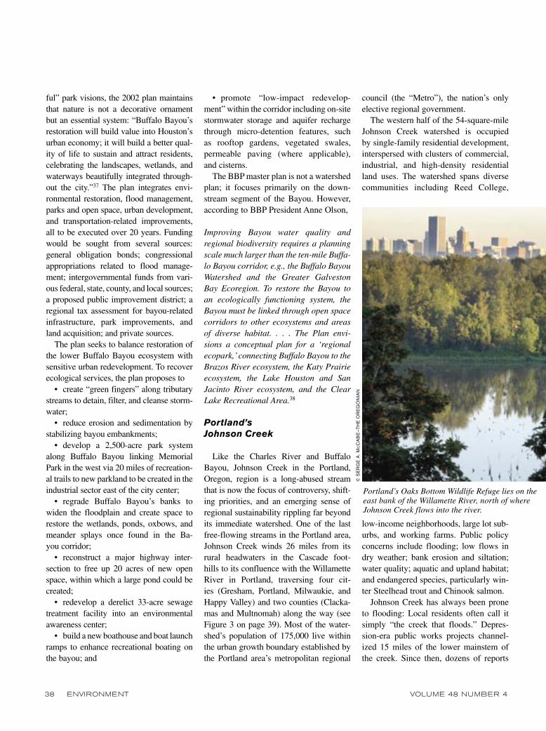
Portland’s Oaks Bottom Wildlife Refuge lies on the east bank of the Willamette River, north of where Johnson Creek flows into the river.
© S
ER
GE
A. M
CC
AB
E—
THE
OR
EG
ON
IAN

MAY 2006 ENVIRONMENT 39
have been produced by various govern-ment agencies proposing various solu-tions to the chronic flood problem and plans to restore native fisheries. Some of these generated intense local opposition. According to local resident and planner Steven Johnson,
The creek has resisted easy remedy for many years. The dozens of reports writ-ten over the past 50 years have offered detailed plans for solving the perpetual flooding problems or, more recently, for bringing back fish populations to address the recent endangered species listings in the lower Willamette River basin. Public agencies have repeatedly come to bat and struck out. [Portland] Metro, still in its infancy, was nearly abolished when citi-zens resisted its plan to solve problems in Johnson Creek.39
As with most urban streams, flood con-trol planning in the early postwar period was a “top-down” process conducted by the Army Corps of Engineers. The Corps’s 1958 Johnson Creek Plan prompted a revolt against a local tax levy for flood control in the mid-1960s and was shelved. A 1969 plan by the Soil Conservation Ser-
vice of the U.S. Department of Agriculture was similarly rejected. The Corps plan was then revised in collaboration with the new Metropolitan Service District (MSD), but that effort was also defeated by local opposition. Portland’s Metro, the region-al government created in 1979 through the merger of MSD and the Columbia Regional Association of Governments, revised the Corps/MSD flood control plan. A newly formed citizen group, the Up the Creek Committee (UTCC), was formed to oppose the Metro plan and its proposed local improvement district. A storm of opposition at public meetings nearly scut-tled the new Metro: After rejection of a tax referendum to fund its operations, Metro abandoned its Johnson Creek plan.
With the repeated failure of “top-down” planning to achieve results, an alternative “bottom-up” approach began to emerge through the efforts of local activists, par-ticularly Steven Johnson, whose family had lived and farmed along the creek for four generations. According to Michelle Bussard, the Johnson Creek Watershed Council’s executive director,
Throughout the nineties, Steve and many others quietly amassed a coalition of
neighborhood conservationists, bureau-crats, and coalition builders. From this unlikely union grew the ‘marching band’ that eddied into Friends of Johnson Creek, eventually plunging into the John-son Creek Watershed Council. Johnson Creek now had the voice it had lacked.40
In 1996, the very year that the water-shed council was formed, Johnson Creek surged to record levels, flooding the streets and damaging homes and businesses. The council’s newly found “voice” was joined by the area’s congressman, Earl Blume-nauer (D–OR), in procuring hazard miti-gation funds from the Federal Emergency Management Agency (FEMA) to acquire selected properties in the floodplain. One of these project sites, after three years of winning over the local neighborhood, would become “Brookside Wetland,” a 20-acre green space acquired with FEMA funds and used for recreation, wildlife habitat, and occasional storage of Johnson Creek floodwaters.
With FEMA’s encouragement, Blume-nauer and the council in 1998 convened the first Johnson Creek Watershed Sum-mit involving public agencies, schools, nonprofits, and private citizens. A vision
SOURCE: Johnson Creek Watershed Council, 2006.
Figure 3. Johnson Creek watershed, Portland, Oregon
North watershed,Portland/Gresham
Gresham area
Headwaters
Badger CreekSunshine Creek
Butler Creek
Kelley Creek
Mitchell CreekMilwaukie area
Crystal SpringsInner SE Portland
SE PortlandVeterans Creek
Portland/ClackamasCounty

40 ENVIRONMENT VOLUME 48 NUMBER 4
statement adopted at the second summit in 1999 offers a model for widespread adaptation: “The Johnson Creek basin will become a healthy, safe, and vibrant watershed by effectively planning for and managing growth, promoting sustainable economic development, and respecting and enhancing the natural functions and benefits of the creek.”41
This statement reflects an emerging new perspective of “ecosystem manage-ment” as applied to the entire watershed, in contrast to earlier plans concerned
only with mainstem flood control. It laid the philosophical foundation for the Johnson Creek Restoration Plan of 2001, backed up by an inter-jurisdic-tional Memorandum of Understanding and establishment of a Political Leaders Committee. The Restoration Plan in turn led to the 2004 Johnson Creek Action Plan, which provides a detailed scien-tific watershed assessment and identifies specific projects and actions to improve watershed health.
These documents are all products of a new “bottom-up” planning process, as facilitated by the Portland Bureau of Envi-ronmental Services (BES), the regional wastewater management agency. Under the leadership of BES, objectives shifted from an earlier dominance of flood problems to a broader suite of goals embracing water quality, wetlands restoration, endangered species, and environmental education.
As with other urban watersheds, the most visible results of basin-scale plan-ning are realized in site-specific restora-
tion projects. Since 1990, roughly 75 such projects have been undertaken in the Johnson Creek watershed.42 Some projects, like Brookside Wetland, are well publicized; many others are small in scale and collectively contribute to improved water quality, flood storage, low-flow augmentation, and habitat improvement.
A bluff overlooking Oaks Bottom Slough—a nesting area for eagles and herons and Portland’s first urban wildlife refuge—affords a striking view.43 Close
at hand is the Springwater Corridor rail trail following Johnson Creek into the city. To the east the blue-green pastels of a three-story high heron mural catch the eye, a work painted by a local artist that brightens a side wall of an otherwise rust-stained, blocky old building. The Portland skyline rises in the background like the Emerald City. This is a glimpse of how enlightened management of local streams, wetlands, and watersheds may contribute to more sustainable and humane metro-politan environments of the future.
Conclusion
Sustainable watershed management is as much an art as a science. As befits the subject matter, the process is “ecological” in that it evolves in different forms in response to differing stimuli and contexts. Each watershed studied is sui generis in terms of physical setting, history, political culture, state and local laws, and leader-ship. The effectiveness of specific strate-gies such as nonpoint source TMDLs,
Urban watersheds provide various ecological services as well as recreational opportunities, as the Portland, Oregon, women’s rowing team demonstrates.
© J
OE
L W
. RO
GE
RS
—C
OR
BIS

MAY 2006 ENVIRONMENT 41
wetland restoration, stream-daylighting, or buyouts of floodprone property are difficult to generalize across watersheds. Each watershed has its own mix of the goals and strategies listed in Table 1, as well as its own cast of players. But cer-tain broad factors were found to be com-mon to watersheds in the University of Massachusetts Amherst study and others reported in the literature:
• the presence of one or more forcing issues that stimulate local concern (for example, flooding on Buffalo Bayou and the Charles River; flooding and fisher-ies restoration on Johnson Creek; and in other areas, offensive odors on the Rouge River in Detroit and poor water quality and lack of public access on the Anacos-tia River);
• the role of community catalysts such as local residents, teachers, scientists, public officials, or nongovernmental organizations;
• the formation of pragmatic alliances or watershed partnerships, such as the Charles River Watershed Association, the Buffalo Bayou Partnership, and the John-son Creek Watershed Council, that seek to bridge conflicting stakeholder interests;
• cultivation of a sense of ownership on the part of watershed and commun- ity residents;
• development of creative funding strategies involving different blends of federal, state, special district, foundation, and individual contributions (complex sets of funding and in-kind matching arrangements are often involved);44 and
• a focus on discrete sites or stream segments due to organizational complex-ity, limited funds and human resources, and the desire to produce “showcase” models to be emulated elsewhere in the watershed or the region and to attract additional funding.
Contrary to expectations, there appears to be a declining role for federal and state regulation because watershed advocates, along with national political leaders, are reluctant to promote “top-down” mea-sures. For example, floodplain manage-
ment under the National Flood Insurance Program is widespread, at least on paper, but its enforcement is largely left to local officials, with varying levels of state and federal oversight. Land use practices that affect water quality and streamflow levels are governed primarily at the local level, with little consideration of negative exter-nalities imposed on downstream jurisdic-tions. Federal and state enforcement of clean water laws is critical to achieving basinwide water quality improvement, as with EPA’s warnings to Charles River polluters in the mid-1990s that prompted reductions in combined sewer overflows and industrial discharges to the river. Municipal governments are ill suited geographically and politically to crack down on local pollution sources to benefit downstream jurisdictions.
Some actions undertaken to satisfy fed-eral or state mandates may be site-specific and unrelated to a basinwide planning context. For example, Section 404 of the Clean Water Act and its state counterparts have stimulated many wetland restora-tions to mitigate the effects of “dredge and fill” of wetlands in other locations. But such projects are spotty and are sel-dom coordinated with watershed-scale planning (the Charles River Natural Val-ley Storage program being the exception that proves the rule). Similarly, flood buy-outs under the National Flood Insurance Program are based on owner and local government cooperation, not watershed-scale flood reduction objectives.
Ongoing modeling and monitoring is essential to evaluate the effectiveness of watershed-scale improvement efforts. Setting total maximum daily load lim-its to control nonpoint source pollution under Section 303(d) of the Clean Water Act has been very uneven, with uncer-tain effectiveness where they have been applied in the absence of adequate moni-toring of ambient water quality. Habitat conservation plans under Section 10(a) of the federal Endangered Species Act have been proposed or adopted to promote fisheries restoration in watersheds like
Johnson Creek, but again, evaluation of their effectiveness depends upon careful, sustained monitoring of fish populations and related biological indicators.
Federal and state regulations are nec-essary but not sufficient to elicit within watersheds a sense of community and cooperative action. Regional leadership at a scale sufficient to encompass the entire watershed is also critical. A regional per-spective for Johnson Creek is provided by Portland Metro and the Portland Bureau of Environmental Services. The Buffalo Bayou Partnership represents a regional coalition of businesses, nonprofits, and government agencies (among which the Harris County Flood Control District has been a major player in the watershed). In Massachusetts, regionalism arises (some-times) from cooperation of towns and state agencies, as in the Natural Valley Storage program in the 1980s. In the case of Watts Branch (see the box on page 30), most improvement efforts are occurring or proposed in the downstream portion of the watershed in the District of Columbia, while the upstream portion in Prince George’s County (Maryland) is less involved.
Urban watershed management thus depends upon creative institutional arrangements, combinations of feder-al and state mandates and incentives, regional partnerships, municipal aware-ness of externalities, and grassroots sense of community. As Lubell and his coauthors put it, watershed partnerships “encourage cooperation between local actors with conflicting interests, diver-gent geographic bases, and overlapping administrative interests.”45 In short, urban watersheds may serve as laboratories for testing new forms of public-private col-laboration, thus pointing the way towards more sustainable governance of urban regions writ large.
Rutherford H. Platt is a professor of geography and planning law in the Department of Geosciences at the University of Massachusetts Amherst. In addition, he directs the Ecological Cities Project, a national pro-gram of research and outreach based at the University of Massachusetts (http://www.ecologicalcities.org). He

42 ENVIRONMENT VOLUME 48 NUMBER 4
specializes in public policy concerning urban land and water resources. He has served on many national panels including the National Research Council Water Science and Technology Board and several of its committees. In 2002, he was honored as a Lifetime National Associate of The National Academies. His publications include Land Use and Society: Geography, Law, and Public Pol-icy (Revised Edition, Island Press, 2004) and Disasters and Democracy: The Politics of Extreme Natural Events (Island Press, 1999). He is editor of The Ecological City: Preserving and Restoring Urban Biodiversity (Univer-sity of Massachusetts Press, 1994) and The Humane Metropolis: People and Nature in the 21st Century City (University of Massachusetts Press and Lincoln Institute of Land Policy, forthcoming).
The author thanks Dennis Wenger, who oversaw the urban watershed research discussed in this article as proj-ect officer at the National Science Foundation. Thanks are also extended to Robert Zimmerman, Steven Cole-man, Michael Lucy, Anne Olson, and Steven Johnson, who reviewed portions of this article.
NOTES
1. L. Mumford, “The Natural History of Urbaniza-tion,” in E. L. Thomas Jr., ed., Man’s Role in Changing the Face of the Earth (Chicago: University of Chicago Press, 1956), 386, 397.
2. W. E. Rees, “An Ecological Economics Per-spective,” in A. R. Berkowitz, C. H. Nilon, and K. S. Hollweg, eds., Understanding Urban Ecosystems: A New Frontier for Science and Education (New York: Springer-Verlag, 2003), 118.
3. R. H. Platt, Land Use and Society: Geography, Law, and Public Policy, Revised Edition (Washington, DC: Island Press 2004); and R. H. Platt, “Toward Eco-logical Cities: Adapting to the 21st Century Metropolis,” Environment 46, no. 5 (June 2004): 10–27.
4. R. H. Platt, “Floods and Man: A Geographer’s Agenda,” in R. W. Kates and I. Burton, eds., Geography, Resources, and Environment, Volume II (Chicago: Uni-versity of Chicago Press, 1986), 28–68.
5. Eighty-ninth U.S. Congress, 2d session, A Unified National Program for Managing Flood Losses, House Document 465 (Washington, DC: U.S. Government Printing Office, 1966).
6. W. H. Whyte, The Last Landscape (Garden City, NY: Doubleday, 1968).
7. A. W. Spirn, The Granite Garden: Urban Nature and Human Design (New York: Basic Books, 1984), 115.
8. G. C. Daily, ed., Nature’s Services: Societal Dependence on Natural Ecosystems (Washington, DC: Island Press, 1997).
9. National Research Council (NRC), Our Common Journey: A Transition Toward Sustainability (Wash-ington, DC: National Academy Press, 1999), 63. For a discussion on megacities, see E. Ezcurra and M. Mazari-Hiriart, “Are Megacities Viable? A Cautionary Tale from Mexico City,” Environment 38, no. 1 (January/February 1996): 6–15, 26–35.
10. NRC, ibid., pages 154–55.
11. The U.S. Geological Survey (USGS) classi-fies U.S. hydrologic units as follows (from large to small): Water Resource Regions, subregions, Hydrologic Accounting Units, and Cataloguing Units or “water-sheds.” USGS, What Are Hydrologic Units? http://water .usgs.gov/GIS/huc.html.
12. American Rivers and The Sierra Club, Where Rivers are Born: The Scientific Imperative For Defend-
ing Small Streams and Wetlands (Washington, DC: American Rivers and The Sierra Club, 2003).
13. American Society of Civil Engineers (ASCE) River Restoration Subcommittee on Urban Stream Restoration, “Urban Stream Restoration,” Journal of Hydraulic Engineering, 129, no 7 (2003): 491.
14. American Rivers and The Sierra Club, note 12 above.
15. W. Graf, “Damage Control: Restoring the Physi-cal Integrity of America’s Rivers,” Annals of the Associa-tion of American Geographers 91, no. 1 (2001): 1–27.
16. ASCE, note 13 above.
17. M. V. McGinnis, “Making the Watershed Con-nection,” Policy Studies Journal 27, no. 3 (1999): 497.
18. D. M. Solzman, “Re-Imagining the Chicago River,” Journal of Geography 100, no. 3 (2001): 118–23.
19. G. F. White, “A Perspective of River Basin Development,” Law and Contemporary Problems 22, no. 2 (1957): 157–87; G. F. White, Strategies of Ameri-can Water Management (Ann Arbor: University of Mich-igan Press, 1969); R. H. Platt, “Geographers and Water Resource Policy,” in M. Reuss, ed., Water Resources Administration in the United States (East Lansing: Michigan State University Press, 1992); NRC, New Strategies for America’s Watersheds (Washington, DC: National Academy Press, 1999); and NRC, Envisioning the Agenda for Water Resources Research in the 21st Century (Washington, DC: National Academy Press, 2001).
20. H. Cortner and M. Moote, “Trends and Issues in Land and Water Resources Management: Setting the Agenda for Change,” Environmental Management 18, no. 2 (1994): 167–74.
21. NRC 2001, note 19 above.
22. M. Lubell, M. Schneider, J. T. Scholz, and M. Mete “Watershed Partnerships and the Emergence of Collective Action Institutions,” American Journal of Political Science 46, no. 1 (2002): 148.
23. NRC, Restoration of Aquatic Ecosystems: Sci-ence, Technology, and Policy (Washington, DC: National Academy Press, 1992).
24. M. V. Mcginnis, J. Wooley, and J. Gamman, “Forum: Bioregional Conflict Resolution: Rebuilding Community in Watershed Planning and Organizing,” Environmental Management 24, no. 1 (1999): 1–12.
25. W. Goldfarb, “Watershed Management: Slogan or Solution” Boston College Environmental Affairs Law Review 21, no. 3 (1994): 487.
26. Major federal drivers of local watershed improve-ment efforts in the United States include the Clean Water and Safe Drinking Water Acts, the Endangered Species Act, the Historic Preservation Act, Superfund, and the National Flood Insurance Program. Funding and techni-cal assistance may be available from the U.S. Corps of Engineers, the U.S. Environmental Protection Agency, and various units of the Departments of Agriculture, Transportation, and Interior. Many of these laws and agencies are paralleled by state counterparts. C. Thom-as, “Linking Public Agencies with Community-Based Watershed Organizations: Lessons from California,” Policy Studies Journal 27, no. 3 (1999): 544–52.
27. “Urban Stream Corridor Management in the United States: The Interaction of Ecology and Policy” (NSF Grant No. CMS-0201409).
28. Ibid.
29. The Charles River case study is derived in part from an unpublished working paper by Sandra Jacquay-Wilson, prepared for the Ecological Cities urban watershed study as a graduate student in the University of Massachusetts Department of Landscape Architecture and Regional Planning. The Buffalo Bayou case study is derived in part from a draft working paper prepared
for the project by Anne Olson, president of the Buf-falo Bayou Partnership (BBP), and Aaron Tuley, a staff member of BBP. The Johnson Creek case study was researched by Heather Ruel as a geography graduate student at the University of Massachusetts. She received help from Steven Johnson of the Johnson Creek Water-shed Council and Daniella Cargill, the Johnson Creek Watershed Manager for the Portland Bureau of Environ-mental Services. Michael Houck of Portland Audubon and the Urban Greenspaces Institute was also a key resource person for this study.
30. One of the nation’s leading state court decisions upholding local floodplain regulation involved one of these sites. Ironically, after the Massachusetts Supreme Judicial Court in Turnpike Realty Inc. v. Town of Dedham 284 N.E.2d 891 (Mass. 1972) held that a town could prohibit building in a wetland without compensating the owner, the site was nevertheless purchased under the Charles River Natural Valley Storage Program.
31. Under state law, most Massachusetts towns and cities have established local conservation commissions. An important function of these bodies is to administer the state Wetlands Protection Act (MGLA Ch. 131, Ch. 40A) which requires any proposal to alter wetlands (defined broadly) to apply to the local conservation com-mission, which issues an “order of conditions” pursuant to a public hearing, regulating how the proposed project should be conducted to minimize harm to wetland resources and services.
32. Robert Zimmerman, executive director of the Charles River Watershed Association (CRWA), in per-sonal communication with author, Newton, Massachu-setts, 1 February 2006.
33. CRWA news release, 15 February 2005.
34. R. Glennon, Water Follies (Washington, DC: Island Press, 2002), 109–11. For more on the Boston Harbor cleanup, see E. J. Dolin, “Boston Harbor’s Murky Political Waters,” Environment 34, no. 6 (July/August 1992): 6–15, 34–39.
35. R. Zimmerman Jr., “Put It in Our Backyard: Water, Science and Sustainable Development,” River Voices: Newsletter of the River Network 15, no. 3 and 4 (2005).
36. See W. M. Alley, “Tracking U.S. Groundwater: Reserves for the Future?” Environment 48, no. 3 (April 2006): 10–25.
37. Thompson Design Group, Inc./EcoPlan, Buffalo Bayou and Beyond: Visions, Strategies, Actions for the 21st Century (Houston: Buffalo Bayou Partnership, 2002), 3.
38. A. Olson and A. Tuley, “The Future of Houston’s Buffalo Bayou,” unpublished working paper prepared for the Ecological Cities Project, University of Massa-chusetts Amherst, 1 September 2004.
39. S. Johnson, “Co-Production of Public and Civic Actions: A Case Study of Citizen Participation in the Johnson Creek Watershed,” unpublished paper presented at International Rivers Symposium, Brisbane, Australia, September 2005.
40. M. Bussard, “Stories from the ‘Shed,’” Within Your Reach: Newsletter of the Johnson Creek Watershed Council, Fall 2005.
41. Johnson, note 39 above.
42. Johnson, note 39 above, page 281.
43. When the city proposed to fill the slough for parking in the 1980s, naturalist Mike Houck and others posted homemade notices declaring it to be a wildlife refuge, and in due course it was so designated by the city.
44. See note 26 above.
45. Lubell, Schneider, Scholz, and Mete note 22 above, page 148.