Operationalizing sustainability in urban coastal systems ...
Vol.3, No.6, 407-416 (2013) Open Journal of Ecology http://dx.doi.org/10.4236/oje.2013.36046
Urban surface water system in coastal areas: A comparative study between Almere and Tianjin Eco-city
Tao Zou1*, Zhengnan Zhou2
1Beijing Tsinghua Tongheng Urban Planning and Design Institute, Beijing, China; *Corresponding Author: [email protected] 2School of Architecture, Tsinghua University, Beijing, China Received 12 August 2013; revised 10 September 2013; accepted 17 September 2013 Copyright © 2013 Tao Zou, Zhengnan Zhou. This is an open access article distributed under the Creative Commons Attribution Li-cense, which permits unrestricted use, distribution, and reproduction in any medium, provided the original work is properly cited.
ABSTRACT
In the purpose of defining typical urban water management challenges in coastal lowlands in the context of global climate change, a com- parative study was conducted between two coa- stal new towns respectively located in the Neth- erlands and Northern China. Comparative me- thod is applied to define main functioning pat- terns of urban water systems in the two cases, then computer simulations were used to further compare drainage capacity in order to reveal the trends of urban water management. Major result has shown that Almere in the Netherlands generally more advanced in urban water man- agement as multiple functioning patterns are available. Strong dykes maintain competence for land subsidence and sea level rise. Open water system decreases local runoff and increases water retention level. Systematic control of sluices and locks which serve for shipping and water- front landscaping are simultaneously isolating contaminants from outer water body. Tianjin Eco-city in China has shown both strengths and weaknesses. It takes large amount of reclaimed water as main landscaping water source, which adapts to local water pollution and shortage while requires highly centralized facilities. Large water body is reserved and huge scale under- ground drainage system built, but it is still vul- nerable to heavy storms due to the lack of effi- cient surface water drainage system. Coastal line control does not adequately prevent from in- creasing storm surge risks in the future. SWMM simulations have supported the viewpoint of dis- tributed surface water with a higher efficiency for storm drainage. Meanwhile, surface water
system returns more added values to urban development. The study is corresponding well with the theory of water sensitive city. As a con- clusion, urban water system should always in- corporate methods to achieve higher system resilience based on multiple functioning pat- terns. Keywords: Urban Surface Water System; Urban Water Management; Coastal Areas; SWMM
1. INTRODUCTION
1.1. Vulnerability of Coastal New Towns
Coastal zones are highly vulnerable to sea level rise in the context of global climate change. Stronger and higher frequency of storm surges poses an increasing threat to coastal urban area, and especially to the infrastructure systems. The main issues include flooding, water re-sources, land loss and water quality as well. Sea level rise may cause immense economic loss due to the direct or indirect damage to the urban areas, sewers, ports and other infrastructure. In China, many coastal lowlands have limited or no human-built protection against im-pacts from sea level rise or storms. Simultaneously the quality of water is likely to decrease, with the fluctuation of runoff that either increased sediments and pollutants or decreased flushing that leads to higher salinity levels. In north China coastal cities, increased salinity is vastly threatening water quality for residential users, and af-fecting crops as well.
Cities located in coastal regions are very vulnerable to extreme weather events. While in recent years, large number of new commercial and residential development in China accelerates the concentrations in coastal areas. In megacities like Shanghai and Tianjin, or city clusters located around them, dozens of new-towns with a
Copyright © 2013 SciRes. OPEN ACCESS

T. Zou, Z. N. Zhou / Open Journal of Ecology 3 (2013) 407-416 408
planned population from 100,000 to 500,000 emerges along coastal low-lying belts, among which Sino-Sin- gapore Tianjin Eco-city is one of the most known pro-jects in China.
Without adequate consideration on the rising risks, the vulnerable costal lowland area has been developed into new settlements. The phrase “Wrong location” is com-monly used when arguing on coastal new towns’ plan-ning. But decision maker’s faithful submission to the rule of urban concentration has led to the adaption of these “wrong places” unavoidable.
Looking back into the near history, European cities had also experienced such fast growing period decades before. Almere is one of them. As an extension of Am-sterdam city, Almere is still considered to be located wrongly due to geological reason [1]. But fortunately enough, Dutch seems far more experienced in coping with coastal risks.
1.2. Introduction on the Study
A comparative study was conducted between two coastal new towns respectively located in China and the Netherlands (Figure 1). The purpose is to define typical challenges and the differences between these urban de-velopments in coastal lowlands. Local strategies for planning the urban surface water system and their func-tioning patterns differ greatly according to local climate and other social-economic situations. In order to further discuss on possible future adaption to extreme weather events, a brief SWMM simulation was applied to each case, so as to compare the two methodologies coping with the same water issues. The comparison intentionally implicates the better orientation of urban water manage-ment in different phases of urban planning.
2. PRELIMINARY STUDIES AND METHODS APPLIED
2.1. Cases General Information
2.1.1. Almere of the Netherlands Initially built as a satellite town of the capital Amster-
Figure 1. Same scale satellite images of Tianjin Eco-city and Almere.
dam, Almere is located in Flevoland of the Netherlands, 20 km away from Amsterdam. The city covers 248.77 km2 in total, including water area of 118.29 km2. As the largest city of Flevoland, Almere has become the seventh largest city in the Netherlands with the population over 180,000 by July 2008. Owing to the expansion plan of Almere, its population is expected to reach 350,000 by 2030.
Almere is a typical polder city. The sea reclamation project in Flevoland is initially planned for agricultural purpose. After the end of World War II, two new polder cities were planned because of the rapid population growth and the increasing house demand. One is Lelys-tad, and the other one is Almere. As one of the latest built cities in the Netherlands, with the first building emerged in 1976, Almere was formally established as a munici-pality until 1984.
2.1.2. Sino-Singapore Tianjin Eco-City Sino-Singapore Tianjin Eco-city (SSTEC, or Tianjin
Eco-city) is an international cooperated new town de-velopment started from 2008. The 34.2 km2 of coastal salinized lowland was chosen in consideration of pre-venting from taking up farmlands in the region. The first phase covers 7.8 km2 of development capable of ac-commodating 105,000 residents in 2015, then 350,000 residents or 110,000 families by 2030 when fully built.
Aiming at a demonstration project of sustainable urban development in China, Tianjin Eco-city is seeking for environmental friendly and low-impact development. Work-life balance and compact-mixed land-use structure, as well as sustainable mass transit system has been largely considered. Water recycling due to regional water shortage is also taken as one of the most important strategies. Large scale reclaimed water plant has been built, and storm water drained through huge scale under-ground piping system.
In the past years, a few families moved into the new eco-city, while national level economic policy has low-ering down the pace.
2.2. Climate and Topographical Backgrounds
Both located in the temperate zone in northern sphere, Almere has higher latitude of 52.37N, while Tianjin Eco-city locates 39.15N. Although much to the south, Tianjin has an annual average temperature not much higher than Almere. The major difference is a colder winter and a much hotter summer in Tianjin.
Annual precipitation in Almere is a bit higher than Tianjin. With a lower annual actual evaporation, Almere shows a wet climate in general. In Tianjin, more than 70% precipitation is received during the hot summer period, and throughout remaining months of the year it
Copyright © 2013 SciRes. OPEN ACCESS
T. Zou, Z. N. Zhou / Open Journal of Ecology 3 (2013) 407-416
Copyright © 2013 SciRes. OPEN ACCESS
409
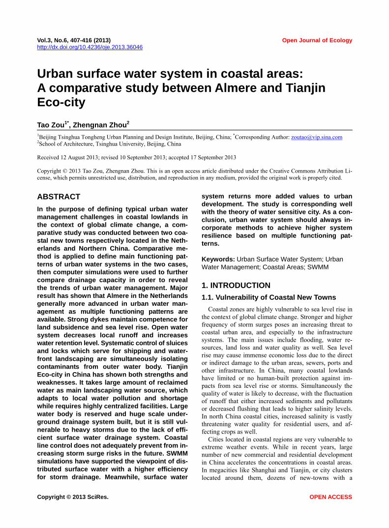
appears very dry. Tianjin is now facing severe water shortage due to high population density and general dry climate as in other northern cities in China (Table 1).
Topographically, Almere is a polder city lying several meters lower than sea-level. The polder is prevented from flooding by strong dykes along the periphery of inside lowlands. Tianjin Eco-city was historically con-sisting of salt fields and a large contaminated reservoir. Dykes for defensing storm surges lie near its border. The whole area is quite flat and mostly around 1 m above sea-level, which will be raised to around 3 m according to its master planning.
2.3. Future Challenges for the Two Cases
Future dilemma in sustainable development for both coastal new-towns is obvious. Among many of the main problems encountered, the following ones are the most harmful and urgent.
2.3.1. Storm Tide Storm tide is one of the most challenges in the context
of global climate change. As about two thirds of land in the Netherlands is highly vulnerable to flooding, it is very important to develop on the reclaimed land follow-ing the huge scale damming. Luckily enough, the risk of storm tides for Almere has been tremendously overtaken by the two dams of Afsluitdijk and Houtribdijk. In con-trast, Tianjin Eco-city is situated much adjacent to Bohai Bay with one and only dam about 500 m away from its southeastern border. Strong tide had historically hit part of the site, and future extreme weather event is threaten-ing this area still.
2.3.2. Land Subsidence Land subsidence is another important issue. Three
quarters of the Netherlands is subsiding, the young and flexible soil of Almere is subsiding even more rapidly.
This process is even intensified by drainage and con-struction, and can only be stopped by the construction of large water storage facilities. In Tianjin, as part of the most densely populated area in Northern China, deep ground water over-exploitation has led to severe land subsidence. This problem overlaps with sea level rise, and has enormously downturn capability of dams origi-nally built for 100 years return period to a much lower level.
2.3.3. Water Shortage Freshwater resource might not be an issue for Almere
due to abundant and evenly distributed precipitation, while Tianjin is facing severe shortage of freshwater during most months in a year and suffers from heavy storms in summer period. Water pollution and saline soil for Tianjin Eco-city are also higher risks for keeping a good urban living quality.
2.3.4. Extreme Weather Event Almere is naturally a part of a polder that totally relies
on the largest pumps in the world, while Tianjin Eco-city is more densely developed with much heavier rains dur-ing the summer period. Extreme weather event, an un-precedented rainfall, could be a rigorous challenge to both cities.
2.4. Comparative Methods Applied
2.4.1. General Research Framework When studying on urban surface water system, it will
naturally relate to other urban water management issues. Ground water and urban infrastructures immensely af-fects surface water system, while only the latter one shows more obvious clues to all who concerns urban form. This might also be the reason why urban planners, in a conventional manner, takes care more on surface water system, and feel less responsible on other unseen
Table 1. Climate and topographical information for both cases.
Tianjin Eco-city (Tanggu)a Almere (Amsterdam)b
Longitude 117.75E 5.22E
Latitude 39.15N 52.37N
Annual average temperature 13.0˚C 9.6˚C
Coldest month average temperature (Jan.) −3.0˚C 2˚C
Hottest month average temperature (Jul.) 26.8˚C 18˚C
Annual precipitation 545.4 mm 755 mmc
Annual actual evaporation - 563 mmc
Annual evaporation from water surface 2025.4 mm -
aClimate data source: Tanggu station from China Meteorological Data Sharing Service System; bClimate data source: http://www.amsterdam.climatemps. com/; eference [2]. cR

T. Zou, Z. N. Zhou / Open Journal of Ecology 3 (2013) 407-416 410
issues. The comprehensive framework of the general program excludes the possible bias. Surface water is di-rectly supported by ground water and infrastructure sys-tem (Figure 2).
2.4.2. Information-Based Mapping and Structuring
In order to understand the urban water systems accu-rately and concisely, structures of these urban water sys-tems have been firstly divided into single elements. These elements were reproduced into ArcGIS and SWMM, thus to form the whole information-based pic-ture of the urban water systems. Data had been collected mainly via site visits and satellite image interpretation, while contribution from local planning authorities and institutes greatly helps to build up a more credible and precise mapping.
2.4.3. Theory of Water Sensitive City Based on the general urban planning philosophy, urban
water management issues are always complex and case sensitive. Thus initial works on the comparison of the operational modes and functions for the two urban water structures are largely related with local situation, in spite of considering the incomparable preconditions that might confuse the results. Introduction of the theory of water sensitive city has apparently clarified the comparative framework. A dimension of time has been added, and the two urban water management systems have been seen evolving.
2.4.4. SWMM Modeling SWMM modeling focusing on storm water drainage
helps further to compare the different structures. As many parameters had been hypothetically setup due to
Figure 2. General research framework.
the lack of precise topographical data, the touch-and-go type of modeling is far from accurate. Thanks to the high similarity of for both cases though, the model fulfills the basic requirements of an urban study at this specific level.
The basic concept is to study on how spatial structure of the systems would affect the storm water drainage efficiency, rather than how pipelines or waterways should be designed. Modeling for both cases is limited to a “proper scale”. In the case of Almere, only main wa-terways are modeled, not any capillary surface water networks or underground storm water pipes have been taken into account. Same in Tianjin Eco-city, drainage pipelines within main sub-catchment area are not in-cluded.
Almere Stat, the center part of Almere, has been simu-lated instead of the whole large region. Rainfalls have been assumed to be the same event cluster, which is 5, 10 and 50 years return period in Tianjin.
3. STRUCTURE AND FUNCTIONS OF THE URBAN SURFACE WATER SYSTEMS
3.1. The Case of Almere
Almere is planned with several semi-independent core areas with blocks, public facilities and location markers. These core areas are connected to the urban center through the public infrastructures. Ditches and various kinds of water bodies intersect in the six urban areas of Almere. The highly efficient surface water system of the polder city is protecting the land from damage, and maintaining social and economic development within this region.
3.1.1. Structure of Surface Water System 1) Lakes Almere is surrounded by water in three sides. The lake
Markermeer in the north is the twin lake of IJsselmeer built in the early Zuiderzee Works. The Markermeer covering 700 km2 is 3 to 5 m in depth. Due to economic and ecological concerns, the area that initially planned to build polder turns to form a lake after building a dam. Nowadays, the Markermeer functions as fresh water res-ervoir, buffering for drought and flood control, and eco-logical conservation as well. IJmeer in the west con-verges with the Markermeer; lake in the south is Goo-imeer. The three external lakes’ water level is very close to sea level.
The entire Almere is below the sea level, and the road elevation is −6.2 to −3.15 m N.A.P. The overall terrain of the planning area is relatively flat; most high-lying areas are located in the southwest; low-lying areas are located in the north. Lake Weerwater in the central part covers
Copyright © 2013 SciRes. OPEN ACCESS

T. Zou, Z. N. Zhou / Open Journal of Ecology 3 (2013) 407-416 411
1.5 km2; Lake North (Noorderplassen) covering 2 km2 is a wetland protection park.
2) Drain and Ditches The polder in which Almere locates carries dense river
network that are mainly functioning as drain and ditches, including high canal, low canal, normal river ways and capillary water net.
High canal, of 50 m in width, collect seepage water and rainwater from higher ground in the south and direct to Ketelmeer in the east. Owing to the large amount of seepage water here, regular flow of high canals is sig-nificant to security, ecology and recreation. Low canals, of 45 m in width, collect excess surface water from lower flow rate area in the middle of polder and use it to adjust the water level. The water quantity of canal is under con-trol, and the water quality is ensured by continuous re-freshing water. The large part of Almere is located at west of the two canals. The staggered network of water in the region plays a significant role to maintain the quantitative and qualitative balance of local water sys-tem.
3) Pumping Stations Pumping station de Blocq van Kuffeler is one of the
largest pumping stations in the world. It is located on the dam where high and low canals meet in the northeast of Almere. The huge structure is put into use in 1967, which is diesel-powered. It maintains the polder’s water eleva-tion with other three pumping stations in Flevolands.
The pumping station comprises four pump units. It works at 85 rpm under normal conditions, with process-ing capacity from 700 to 850 m3/min. The pump unit can work for 600 to 900 hours during the dry season, and 1200 hours during the rainy season.
4) Weirs and Sluices Weirs are mainly used to adjust the water level. Mov-
able weirs are adopted to better control the height of the regulated water. This kind of weir, with a movable flap valve, allows excess rainwater passing through the weir in the condition of heavy rainfall, and then the water surface elevation gets back to the present level. Most of the weirs are automatic or semi-automatic. Water is di-rectly discharged into the canal through the weirs.
3.1.2. Operational Modes and Function Analysis As a typical polder city, the basic goal for Almere is to
maintain a long-term stability of surface water level in the polder. This is essential not only to ensure safety of the city with an expected population of 350,000 in the future, but to exert the functions of urban water system in ecology, recreation and transportation. Water quality must be kept in good conditions to fully achieve these func-tions.
A key climate feature of the region is the relatively even distributed rainfall all the year round, with a sig-
nificant difference of evaporation between winter and summer. Therefore, “flood in winter and drought in summer” emerges regularly, and the urban water system can be roughly defined as two “operational modes”: “winter mode” and “summer mode”. In colder seasons, excess surface water is discharged from the polder to the outside water body, so as to prevent flooding from occur-ring in reclaimed land for urban construction and agri-cultural use; in warmer seasons of the year, external wa-ter is introduced to the polder to ensure stability of re-gional hydrological system, and to meet agricultural wa-ter demand and protect dams from damage as well. In different management regions, the internal water level control in winter and summer are mostly the same, with some slight difference in certain area. Throughout the year, “winter mode” is generally longer because the av-erage annual rainfall (755 mm) is exceeding the total evaporation (563 mm) up to 192 mm [2] (Figure 3). In addition, when rainstorm comes, the water system in the polder will turn to “flood relief mode” which pose greater challenge to the system’s draining efficiency.
Almere and the polder’s water system implements three important functions in these operating modes, which show great hints for future urban development of coastal areas.
1) Damming System: Defense Seawater Intrusion Almere is under the protection of three dams, respec-
tively built in the projects of the Ijsselmeer formed in the early Zuiderzee Works, the Markermeer formed in the Markermeer project, and the south Flevoland polder pro-ject. These dams have completely prevented seawater intrusion.
The standards on hydraulic engineering design and construction in the Netherlands are extremely high. The
Figure 3. Averaged monthly rainfall and precipitation in milli-meters (1971-2000) over the period of one year in the Nether-lands. Well visible is that the evaporation is exceeding the pre-cipitation during the summer months [2].
Copyright © 2013 SciRes. OPEN ACCESS

T. Zou, Z. N. Zhou / Open Journal of Ecology 3 (2013) 407-416 412
32 km-long Afsluitdijk was completed in 1932 under the design standard of flood with recurrence interval of ten thousand years. It is 3.5 m higher than the given highest tide, and 90 m wide at the sea level, equipped with strict impermeable measures. The dam is still intact even it has experienced maritime storm surges for many times [3].
The Markermeer project has not been fully completed, but the 28 km-long Houtribdijk dam becomes the second line of defense. Markermeer is also a key buffer and pro-tection element for this region. In 2003, the Netherlands suffered a severe drought and many dams were threat-ened. Water was transferred from Markermeer to sur-rounding polders imminently, which effectively kept the soil moist and ensured the dam safe.
The multi-layer dam system under scientific and strict management is quite sufficient to handle the storm surges that may increase in the future, and to deal with coastal problems caused by land subsidence and sea level rise.
2) Highly Expanded Open Water System: Higher Re-silience Dealing with Floods
The standard drainage capacity of the Netherlands can be converted as 14 mm rainfall drainage per day, and the designed drainage capacity of Flevoland polder is 11 to 18 mm per day [4]. This drainage standard is very high, but still difficult to resist occasional heavy rain. For ex-ample, 24 hours rainfall in parts of the Netherlands had reached 130 mm in September 1998, which exceeded the drainage capacity and resulted in flooding in extensive agricultural and urban areas. Over the past few years, such situations made the Netherlands lose billions of euros [5].
These make people realize that a climate proof rain-water management method has to ensure a sustainable and flexible rainwater management system in the polder. The system may achieve selective storage in clean rain-water season, and realize rain flood regulation and stor-age under extreme precipitation. Although maintaining larger open water area may limit urban development and building use, it is almost impossible to result in rainwater infiltration and underground storage because of the higher water table, small drying height and non-permeable soil structure in the polder. Therefore, expanding use of open water to capture and store rainwater is widely recognized. Based on the Netherlands’ guidelines for water resources management in the future, local water affairs manage-ment institutes keep the following idea: in the new urban development, open water shall account for 10% of the total land area [6]. In the Flevoland polder, the early open water accounts for only 1%, this is currently ex-panded to 4%. In the region of Almere with concentra-tive construction, nearly 4 km2 lakes within the polder in the northern, central and southern parts and the ditches all over the city become important buffer water to deal
with storm disaster. Large water storage facilities and extensive open water system greatly reduce surface run-off, as well as construction and operational costs of urban infrastructure.
3) Dynamic Closed Water System: Self-Cleaning In-ternally
Water management system for Netherlands polder is based on considering each polder as an independent wa-ter system, which is mainly to control the stability of the groundwater and surface water elevation. Because of climate reason, the stability of the water level within the polder cannot be self-sustaining. In winter with less evaporation, the excess rainwater will be pumped into the canal at higher terrain, and ultimately discharged into the external lake. The process is reverse in summer, wa-ter must be introduced from external lakes, so as to add water and prevent the water level lowered. The control process is effective to ensure stable water quantity, maintain boating conditions, coastline landscaping and ecological services. Simultaneously, it is able to separate water within the polder from pollutants out in the exter-nal water bodies.
Nevertheless, researchers are still working on the sus-tainability of water management system. The system is still lacking of sufficient inherent resilience, a large amount of relatively clean rainwater is discharged, but much polluted external lake water is also introduced in-ward in the opposite case. Thus, there is certain risk of water quality decrease. So there comes a challenge to avoid cleaner internal water being discharged, and to prevent external pollutants from canals and rivers. In order to achieve this goal, expanding the open water is an important way to collect clean rainwater, as much as possible. However, for the purpose of maintaining good inter-seasonal water quality in a closed system, sewage plant should be fully used and its drainage standards should be improved. Besides, hygrophyte around the lake shall be used to purify the water, such as reed in ponds and ditches.
At the same time, the so-called “circulation model” [7] for sub-areas is vastly established in Almere in accor-dance with the water level control. This method is not only conducive to water quality maintenance at low cost, but also improve the quality of urban landscape.
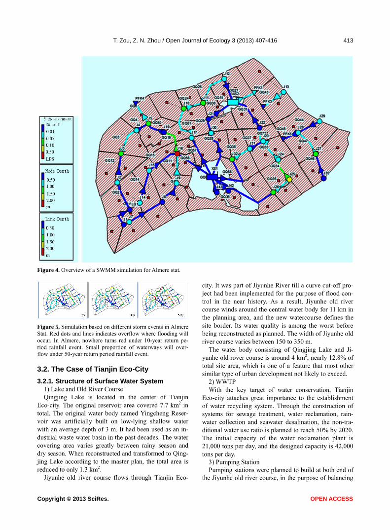
3.1.3. SWMM Simulation Overview: The Case of Almere
Total sub-catchment area of Almere Stat is 26.17 km2. It has been divided into 58 sub-catchment areas. 2 reten-tion water bodies have been settled. Main waterways width from 35 to 40 m, branch waterways width from 15 to 27 m, distributes with a total length of 29.5 km (Fig-
res 4 and 5). u
Copyright © 2013 SciRes. OPEN ACCESS
T. Zou, Z. N. Zhou / Open Journal of Ecology 3 (2013) 407-416
Copyright © 2013 SciRes.
413
Figure 4. Overview of a SWMM simulation for Almere stat.
Figure 5. Simulation based on different storm events in Almere Stat. Red dots and lines indicates overflow where flooding will occur. In Almere, nowhere turns red under 10-year return pe-riod rainfall event. Small proportion of waterways will over-flow under 50-year return period rainfall event.
OPEN ACCESS
3.2. The Case of Tianjin Eco-City
3.2.1. Structure of Surface Water System 1) Lake and Old River Course Qingjing Lake is located in the center of Tianjin
Eco-city. The original reservoir area covered 7.7 km2 in total. The original water body named Yingcheng Reser-voir was artificially built on low-lying shallow water with an average depth of 3 m. It had been used as an in-dustrial waste water basin in the past decades. The water covering area varies greatly between rainy season and dry season. When reconstructed and transformed to Qing- jing Lake according to the master plan, the total area is reduced to only 1.3 km2.
Jiyunhe old river course flows through Tianjin Eco-
city. It was part of Jiyunhe River till a curve cut-off pro-ject had been implemented for the purpose of flood con-trol in the near history. As a result, Jiyunhe old river course winds around the central water body for 11 km in the planning area, and the new watercourse defines the site border. Its water quality is among the worst before being reconstructed as planned. The width of Jiyunhe old river course varies between 150 to 350 m.
The water body consisting of Qingjing Lake and Ji-yunhe old rover course is around 4 km2, nearly 12.8% of total site area, which is one of a feature that most other similar type of urban development not likely to exceed.
2) WWTP With the key target of water conservation, Tianjin
Eco-city attaches great importance to the establishment of water recycling system. Through the construction of systems for sewage treatment, water reclamation, rain-water collection and seawater desalination, the non-tra- ditional water use ratio is planned to reach 50% by 2020. The initial capacity of the water reclamation plant is 21,000 tons per day, and the designed capacity is 42,000 tons per day.
3) Pumping Station Pumping stations were planned to build at both end of
the Jiyunhe old river course, in the purpose of balancing

T. Zou, Z. N. Zhou / Open Journal of Ecology 3 (2013) 407-416 414
interior water amount and quality control as well. The whole interior water body is thoroughly connected with-out weirs or sluices.
Considering reasonable circulation, another solution is also under discussion: a two-way pumping station built in upper end of the Jiyunhe old river course, and a sluice placed at the lower end.
4) Isolated Ponds The whole urban surface water system consists pre-
dominantly with large water body, and there’s only two planned isolated ponds loosely connected with Jiyunhe old river course. These waterway-like ponds were planned to be ecological corridors connecting inside water body to the peripherals. But since they are locating higher, serving like a catchment border, rain water will not be collected through natural processes. Their actual function is more visually driven rather than a green ecological corridor.
5) Rain Water Piping System Rain water is generally collected via piping systems
divided in 4 sub-regions. Within each sub-region, very large section pipes and tunnels are densely distributed and deep buried into ground. The largest section can be up to nearly 16 m2, and bury more than 3 m deep at the outlet of each sub-region. Storm water is then pumped out into the lake and old river course. The whole system is built like a waterway system underground.
3.2.2. Operational Modes and Function Analysis The case of Tianjin Eco-city has chosen specific meas-
urements in coping with the urban water functioning patterns. The basic logic can be seen as highly concen-trated system with large scale planning and design.
1) Water Reclamation as Main Water Resource The first and the most featured functioning pattern is
taking large amount of reclaimed water as main water resource, thus simultaneously transforming a waste water basin into a clean water body for urban landscaping and recreational purpose. This substantially adapts to water pollution and shortage situation that might as well exists in other regions. But it requires highly centralized waste water treatment facilities and strictly monitored outlet water quality in accordance with the scale and sustain-able target.
In late summer, water quality in Jiyunhe River is the best of a year owing to abundant precipitation in the re-gion. It is the best period of time to pump water from external water body to Jiyunhe old river course so as to replenish water for the interior water bodies. In the rest of a year, reclaimed water from the water reclamation plant will be used for replenishment. Water from the Qingjing Lake will also be directed to the water reclama-tion plant for processing when its quality degrades.
Presently, water output from the WWTP meets First
Class B, which will be improved to First Class A in the future. According to First Class A, the N, P concentration limits will be able to achieve that of the National Re-claimed Water Quality Standard, but the salinity could still be very high. Therefore, WWTP outlet water should then send for membrane treatment processes in the water reclamation plant to meet Reclaimed Water Quality Standard.
The high salinity of water output from sewage treat-ment plant is another challenge. It is primarily caused by the following reasons: high salinity of underground water; serious leakage problems of old drainage pipe systems in Hangu and surrounding areas; pipelines passing through many abandoned salt fields, which make the high-salin- ity underground water leak into drainpipes; high-salinity effluent from surrounding chemical plants also connect-ing to drainage pipe system, and eventually discharged to the sewage treatment plant.
2) Circulation model as a Way against Eutrophication At present, the water body of Qingjing Lake circulates
counter clock, with the water reclamation plant in-taking water in the north and discharging in the south. The wa-ter body of Jiyunhe old river course circulates clockwise. Qingjing Lake and Jiyunhe old river course are con-nected by culverts and pumping stations. However, the bottom of Qingjing Lake is high in north and low in south, which is not conductive to reverse circulation by itself. On the other hand, for the southwest section con-necting Jiyunhe River to Jiyunhe old river course, water quality tends to degrade due to poor liquidity.
In master planning, two connecting ends of Jiyunhe old river course and Jiyunhe River will be built with pumping stations for water exchange. However, the cur-rent strategic tendency is that the north end being equipped with a two-way pump which is able to drain and replenish, and the south end built with a sluice.
3) Large Area of Water Body Serve for Visual Land-scaping
Large volume of water body is planned, but the de-signing purpose is originally intended to be more visu-ally rather than ecological functions. As the main water body is relatively concentrated, the site is still vulnerable to heavy storms due to the lack of efficient surface water drainage system.
3.2.3. SWMM Simulation Overview: The Case of Tianjin Eco-City
Total sub-catchment area of Tianjin Eco-city is 19.04 km2, which has been divided into 4 main sub-regions according to the planning. Main pipelines diameter ranges from 1.2 to 2.2 m, piping tunnels section area from 5 to 16 m2 with a total length of 63.2 km (Figures 6 and 7).
Copyright © 2013 SciRes. OPEN ACCESS

T. Zou, Z. N. Zhou / Open Journal of Ecology 3 (2013) 407-416 415
Figure 6. Overview of a SWMM simulation for Tianjin Eco- city.
4. DISCUSSION
4.1. Largely Distributed Surface Water System Gains Higher Drainage Efficiency
Storm water drainage system in Tianjin Eco-city is one key feature in its master planning. The scale and design size of the piping networks are surprisingly huge. How-ever, deeply buried pipelines and tunnels have apparent bottleneck effect in terms of the drainage efficiency. Namely, they couldn’t drain properly once a pipeline is fully loaded, blocked or poorly drained.
This will not occur to open watercourses which are more flexible. Most waterways in Almere are built with rectangular cross-section and trapezoid revetment. There- fore, their watercourses have certain degree of flexi-
Figure 7. Simulation based on different storm events in Tianjin Eco-city. Red dots and lines indicates overflow where flooding will occur. A large proportion of drainage pipes and tunnels turn red under 10-year return period rainfall event. Massive overflow occurs under 50-year event. bility capacity in case of heavy rains. Especially, revet-ments formed on the basis of natural slope protection have inhibiting effects on water surge problems.
It can be seen from the simulation for the above two cases, the widely distributed surface water system of Almere is more efficient with less overloading problem in the drainage path under the same rainstorm reoccur-rence period. Furthermore, the two cases are extremely different in utilization effects, although both of them have large open water body. In Tianjin eco-city, converge of water in sub-catchments ultimately flows to the deeply buried pipes, and eventually pumped to the lake. This poses main challenge to the drainage efficiency.
The widely distributed open water network shows ob-vious advantages to improve drainage efficiency, in-crease flexibility and ensure stability.
4.2. Surface Water System Takes up Some Land but Returns Added Value
Open surface water system will take up some of the urban space, which may be an overly extravagant choice for high-density urban area. However, parks and green-belts are essential for planning for most proportions of the urban development areas. These open spaces can be combined with water or low-lying land, and will form attractive urban space. In this case, the urban space oc-cupied by the open water system will return added value in another good way. It can be seen from Almere, the open water system combined with the lake forms a wa-terfront space for the city, which is more comfortable and interesting than a vast open water area.
4.3. Both Cases Are Specifically Developing towards Water Sensitive City
The theory of water-sensitive city provides us a way to
Copyright © 2013 SciRes. OPEN ACCESS

T. Zou, Z. N. Zhou / Open Journal of Ecology 3 (2013) 407-416
Copyright © 2013 SciRes.
416
understand the development course of urban water sys-tem management. Tianjin Eco-city, as a case of emerging economy, can be considered as the development stage just entering the drained city from a sewer city. Almere, also as a typical polder city, has developed into a water-way city in advance. From this point of view, Tianjin Eco-city shall take Almere as an example to learn from.
OPEN ACCESS
Tianjin Eco-city is suffering serious water scarcity which restricts its development. It has put forward the planning program of taking full use of reclaimed water, which to some extent is transforming to a water cycle city. In this aspect, Tianjin Eco-city seems more ad-vanced. It may also be a reference to the future city de-velopment.
5. CONCLUSIONS
With higher frequency of extreme climate events, glo- bal climate change is challenging the urbanization proc-ess and population concentration in coastal zones. Al-though there are many differences in premises and back-grounds comparing with Asian coastal cities, Dutch pol-der cities have demonstrated the potential dealing logic and operation methods under extreme cases.
Almere with its typical layout of polder city, dispersed settlements, dense river network, large area of open wa-ter body, precise control of water level, efficient drainage system, sound damming system, provides us with many experiences in coping with the potential coastal risks in low-lying areas. For the many coastal new town con-struction projects in emerging economies, such as Tianjin Eco-city, more skills must be acquired to prevent sea-water intrusion, to maintain internal water balance, and to achieve good water quality, so as to lay a more solid foundation for urban sustainable development locally and globally.
Climate challenges will be a long-term issue for coastal cities that are seeking for larger and denser de-velopments. In the coming decades, the necessities for learning how to adapt to larger range of uncertainty are crucial requirements for urban planners. As a conclusion,
the urban water system planning should always incorpo-rate methods to achieve higher system resilience based on multiple functioning patterns.
6. ACKNOWLEDGEMENTS
Thanks to H. M. de Brauw for discussions on related models. Also
thanks to Mingyi Li, Jiexin Cheng for their help on calculation and
simulation studies, thanks to Jianjia Wang for her translation work.
The project is supported by International Science & Technology Co-
operation Program of China (2010DFA74490).
REFERENCES
[1] Hooimeijer, F.L., Meyer, H. and Nienhuis, A. (2005) At- las of Dutch water cities. Sun Architecture, Amsterdam.
[2] Schuetze, T. (2011) Climate adaptive urban design with water in Dutch polders. Water Science and Technology, 64, 722-730. http://dx.doi.org/10.2166/wst.2011.688
[3] Zhou, C. (1987) Helan shuili guanli gaishu. Guangdong Hydropower Technology, 1.
[4] Schuetze, T. and Chelleri, L. (2013) Integrating decen- tralized rainwater management in urban planning and de- sign: Flood resilient and sustainable water management using the example of coastal cities in the Netherlands and Taiwan. Water, 5, 593-616. http://dx.doi.org/10.3390/w5020593
[5] Dam, P.J. (2001) Sinking peat bogs: Environmental change in Holland, 1350-1550. Environmental History, 6, 32-45. http://dx.doi.org/10.2307/3985230
[6] Tjallingii, S. (2008) The water issues in the existing city. In: Hooimeijer, F. and Toorn Vrijthoof, W.V.D., Eds., More Urban Water: Design and Management of Dutch Water Cities, Urban Water Series, Taylor & Francis/Bal- kema, Leiden.
[7] Tjallingii, S. (1996) Ecological conditions. Strategies and structures in environmental planning. Vol. 2, IBN Scien- tific Contributions, DLO Institute to Forestry and Nature Research (IBNDLO), Wageningen.