Urban Flood
21
Flood control urban areas matteo pochintesta POLITECNICO DI MILANO climate and hidrology
-
Upload
matteo-pochintesta -
Category
Documents
-
view
228 -
download
2
description
Climate and Hydrology
Transcript of Urban Flood
Flood controlurban areasmatteo pochintestaPOLITECNICO DI MILANO
clim
ate
an
d h
idro
log
y

1.High rainfallHeavy rainfall raises the water level. When the water level is higher than the river
2.SnowmeltBecause of global warming, the temperature of this year is higher than the tempera-ture of many years ago.The ice caps melt in spring, and the water goes into the sea. The water raises the sea level, and makes the river level rise. When river level
3.Relief-
Flooding always occurs in coastal areas. High tides or storms cause the water level
occur.
FLOODS IN THE WORLD1
Causes of FloodsNatural causes

1.DeforestationLarge areas of forests near the rivers have been cleared. Less vegeta-tion protects the soil, the soil is quickly lost to rivers and the sea.This
2.Poor farmingSome farming practices can damage the vegetation cover, so the soil will be washed into the river easily.Overgrazing: Grazing too many animals on the land means less veg-etation cover, resulting in soil washed into the rivers easily.Overcultivation: When a piece of land has been used for farming for a long period of time, the soil may became so infertile that no vegeta-tion can grow on it. The land is less fertile than before so the soil washed into the rivers easily.3.Poor water managementWhen the dams are poorly constructed or maintained ,they can easily
4.Population pressureLarge amounts of people causes consequently overgrazing and over-
-populated chinese city areas.
URBAN FLOODS
Human causes

The Garrison Dam in North Dakota
White Oak Bayou detention basin
Diversion channel Levees sectional scheme
1. Structural1. Afforestation - planting trees increases interception rates and re-duces surface runoff.
Dams and Reservoirs
Diversion Channels and Detention basin
Channel Straitening and Dredging - smoothens the channel to -
age basin as quickly as possible.5. - makes river banks higher therefore holding more water.6. Culverts - semi circular, smooth channels increase velocity and gets water away from urban areas as quickly as possible.
Revetments and Channel Walls - strengthen river banks from erosion.
2. Territorial rules and regulations3. Compulsory insurance4. Warning and evacuation
FLOOD CONTROL
clim
ate
an
d h
idro
log
y
Flood Control and Management
1.High rainfallHeavy rainfall raises the water level. When the water level is higher than the river
2.SnowmeltBecause of global warming, the temperature of this year is higher than the tempera-ture of many years ago.The ice caps melt in spring, and the water goes into the sea. The water raises the sea level, and makes the river level rise. When river level
3.Relief-
Flooding always occurs in coastal areas. High tides or storms cause the water level
occur.
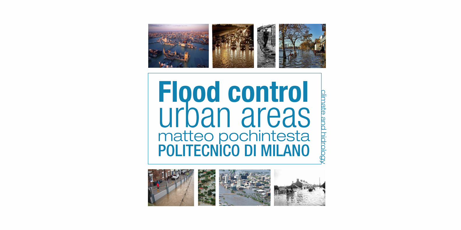
The Saint Petersburg
near Saint Petersburg, Russia. The dam extends from Lomonosov northward to Kotlin Island , then turns east toward
The complex is intended to protect Saint Petersburg from storm surges by separating the Neva Bay from the rest of the Gulf of Finland. Historically, the storm surges from the gulf had caused over 300
The Eastern Scheldt storm surge barrier, between the islands Schouwen-Duiveland and Noord-Beveland, is the largest
works series of dams, designed to protect the Neth-
construction of it and of the Maaslantkering were in response to the North Sea
The MOSE is a project intended to protect the city of Venice, from
defense system consisting of rows of mobile gates able to isolate the Venetian Lagoon from the Adriatic Sea when the tide reaches above
m. Together with other complemen-tary measures such as coastal rein-forcement, these barrier will protect the city of Venice from extreme
morphological degradation.
The Thames Barrier is the world's second-largest mov-
located downstream of central London. Its purpose is to prevent London from being
tides and storm surges moving up from the sea. It needs to
high tide; at ebb tide it can be lowered to release the water that backs up behind it.
The -tion
concrete steps and wide pedestrian
bay, whilst allowing people to meander from the high street to the beach. Private investment initiatives and public engagement groups have joined together in order to share the owner-ship of the promenade and to manage a diverse array of commercial, leisure and recreational activities for both residents and visitors.
EXAMPLES 4
Dutch barriers Thames barrier Cleveleys tidal barrierVenice barrier (Mose)St Petersburg Dam
Thames Estuary Flood Defence System
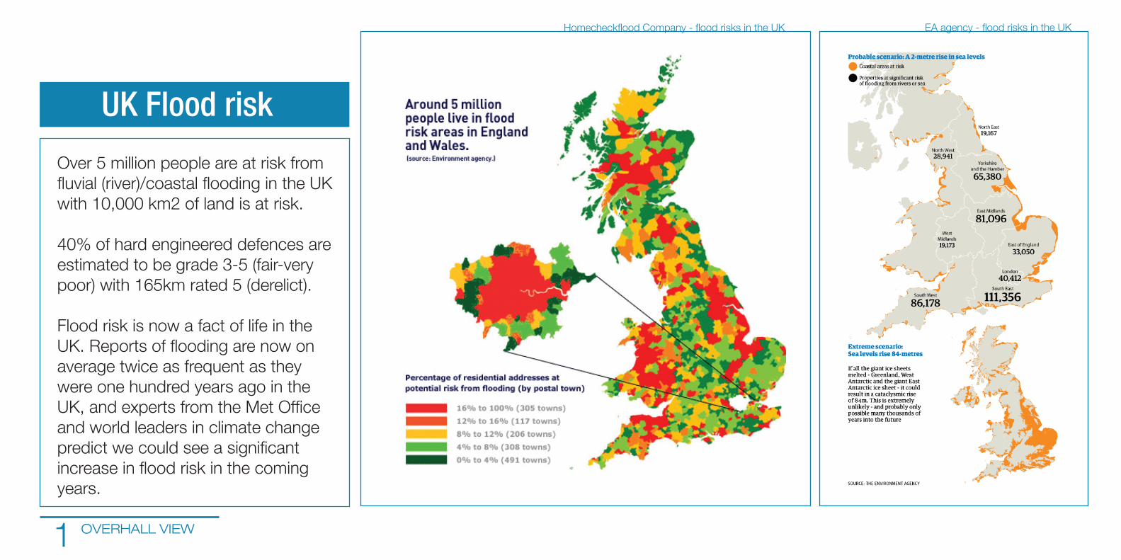
Over 5 million people are at risk from
OVERHALL VIEW
UK Flood risk

The Thames estuary is the meeting place of the freshwater River Thames, its many tributaries and the North Sea. Everyday, twice a day the freshwater Thames which
London is met by the incoming tide from the North Sea. The Thames estuary has an average daily rise and fall of water levels of 7 m.In addition to the daily tides, the Thames estuary is prone to an increase in water levels caused by a North Sea surge.
SURGE TIDE

Today, this is a dated estimate and given the pace of global warming, with 1.25million people vulnerable
necessary.
SURGE TIDE FLOOD SCENARIO

options:
-Abandoning -Reshaping
FUTURE SCENARIOS 4

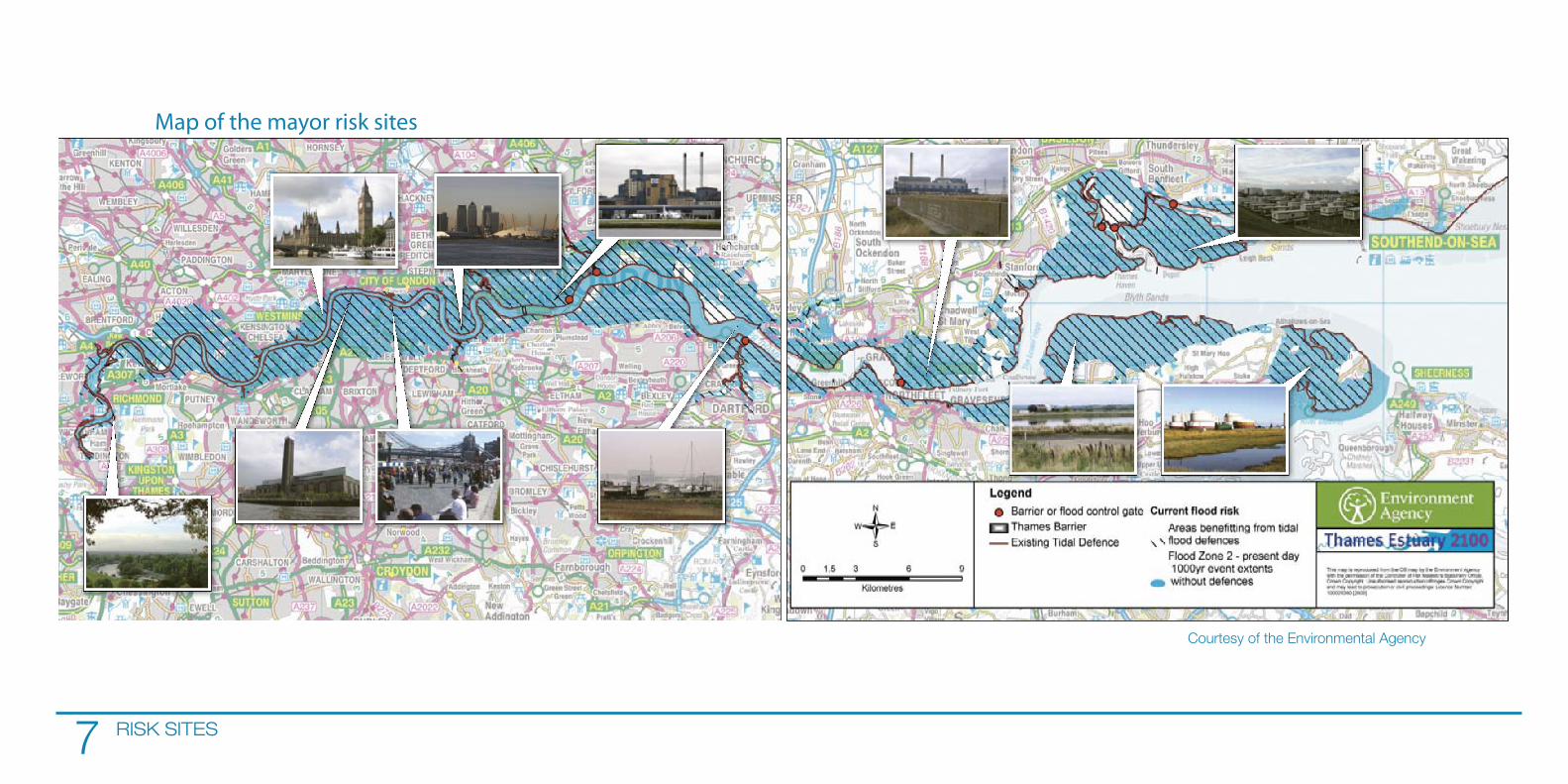
FUTURE SCENARIOS RISK SITES5
What is at at risk?

RISK SITES
options:
-Abandoning -Reshaping
RISK SITES
Map of the mayor risk sites

were tidal defences on the Thames estuary more than 1500 years ago. These defences protected Anglo-Saxon settlements in Kent and Essex.
HISTORYCAL INTERVECTIONS
Thames levees

HISTORYCAL INTERVECTIONS THE BARRIER
Thames barrier

DEFENCE SYSTEM

DEFENCE SYSTEM THE BARRIER
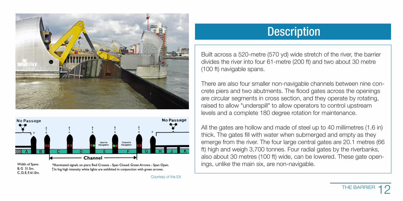
THE BARRIER
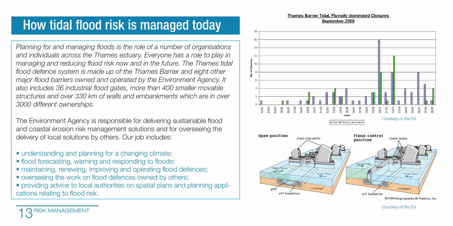
and individuals across the Thames estuary. Everyone has a role to play in
3000 different ownerships.
RISK MANAGEMENT
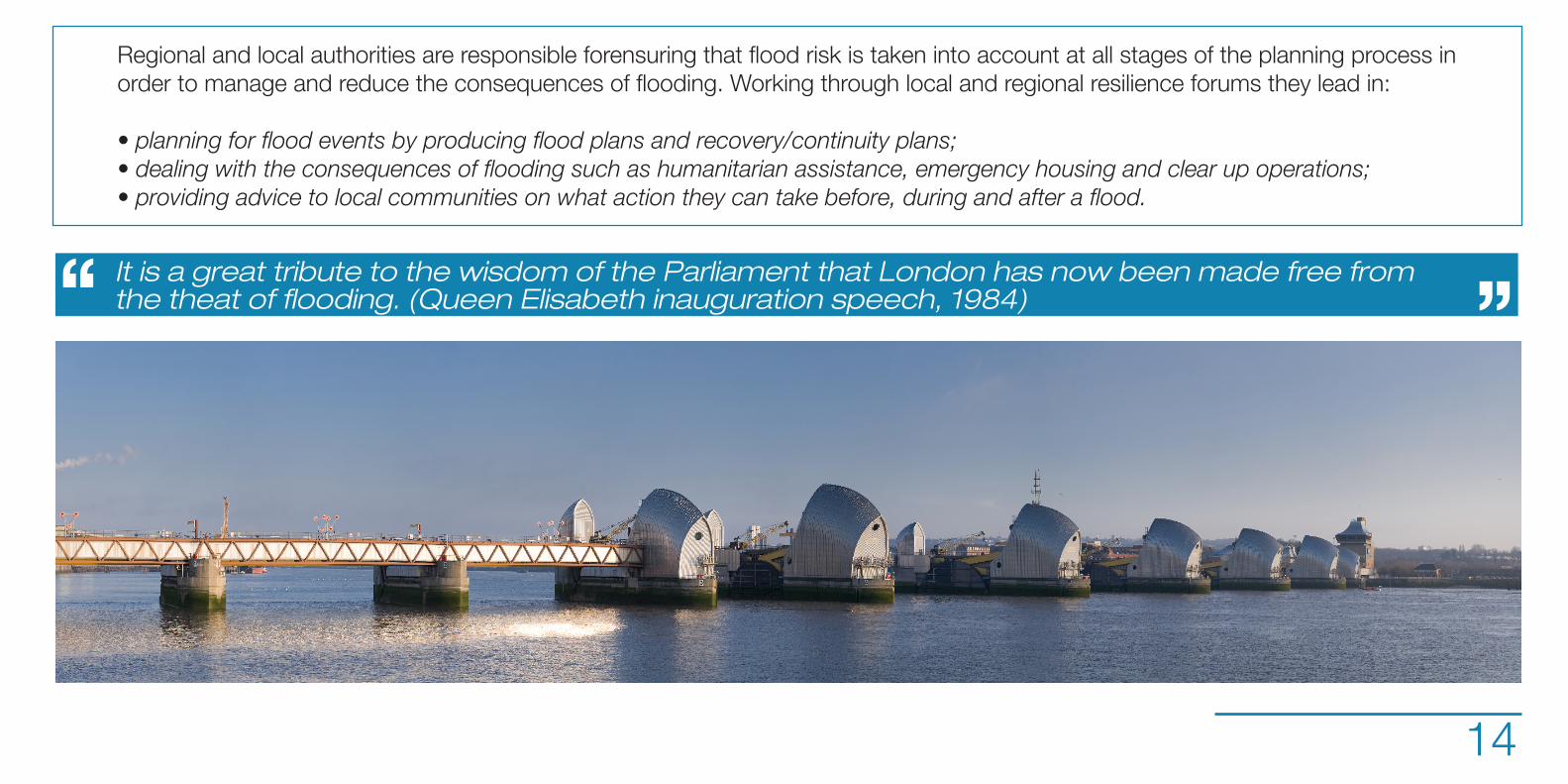
It is a great tribute to the wisdom of the Parliament that London has now been made free from