Urban Design 5
11
The Development Guidelines and Streetscape Standards established in this chapter will ensure that new development in the Station Area corresponds to, supports, and accomplishes the vision and goals set forth in this document. These Guidelines and Standards promote vibrant and attractive new development, streetscape improvements, and public gathering places. The Development Guidelines and Streetscape Standards serve as the primary authority for all design issues in the Station Area, regardless of whether they are addressed in San Mateo’s Zoning Code. Although no conflicts are anticipated with other documents, should any arise these Development Guidelines and Streetscape Standards shall take precedence over the Code, and by extension the San Mateo Rail Corridor TOD Plan and El Camino Real Master Plan, where either one applies in the Station Area. Any projects not within a designated area described in this chapter are subject to the existing regula- tions in the City’s Code. The multi-family residential areas off of El Camino Real are not the subject of focus of the design guidelines in this chapter, as the City’s Multi-Family Design Guidelines address that type of development. The Development Guidelines and Standards contain language that reflects the following principles: • “Shall” or “Must” indicate a design standard and means that conformance is manda- tory. • “Should or “Strongly Encouraged” mean that conformance will be strongly encour- aged by the City through the review process and that the guideline is intended to be a recommendation about how to implement the goals for development. Focus Areas The Design Guidelines and Streetscape Standards are created to bring to fruition the urban design concepts proposed in the focus areas below. These concepts embody the Guiding Principles and are illustrative of the type of development and public improve- ments that are envisioned for the implementation of this Station Area Plan. Following a discussion of the focus areas in this section, specific development standards and streetscape standards are listed in the sections that follow. Urban Design 5 55
Transcript of Urban Design 5
The Development Guidelines and Streetscape Standards established in this chapter
will ensure that new development in the Station Area corresponds to, supports, and
accomplishes the vision and goals set forth in this document. These Guidelines and
Standards promote vibrant and attractive new development, streetscape improvements,
and public gathering places.
The Development Guidelines and Streetscape Standards serve as the primary authority
for all design issues in the Station Area, regardless of whether they are addressed in San
Mateo’s Zoning Code. Although no conflicts are anticipated with other documents,
should any arise these Development Guidelines and Streetscape Standards shall take
precedence over the Code, and by extension the San Mateo Rail Corridor TOD Plan and
El Camino Real Master Plan, where either one applies in the Station Area. Any projects
not within a designated area described in this chapter are subject to the existing regula-
tions in the City’s Code. The multi-family residential areas off of El Camino Real are not
the subject of focus of the design guidelines in this chapter, as the City’s Multi-Family
Design Guidelines address that type of development.
The Development Guidelines and Standards contain language that reflects the following
principles:
• “Shall” or “Must” indicate a design standard and means that conformance is manda-
tory.
• “Should or “Strongly Encouraged” mean that conformance will be strongly encour-
aged by the City through the review process and that the guideline is intended to be
a recommendation about how to implement the goals for development.
Focus AreasThe Design Guidelines and Streetscape Standards are created to bring to fruition the
urban design concepts proposed in the focus areas below. These concepts embody the
Guiding Principles and are illustrative of the type of development and public improve-
ments that are envisioned for the implementation of this Station Area Plan. Following
a discussion of the focus areas in this section, specific development standards and
streetscape standards are listed in the sections that follow.
Urban Design 5
55
56 City of San Mateo | Hillsdale Station Area Plan
5 Urban Design
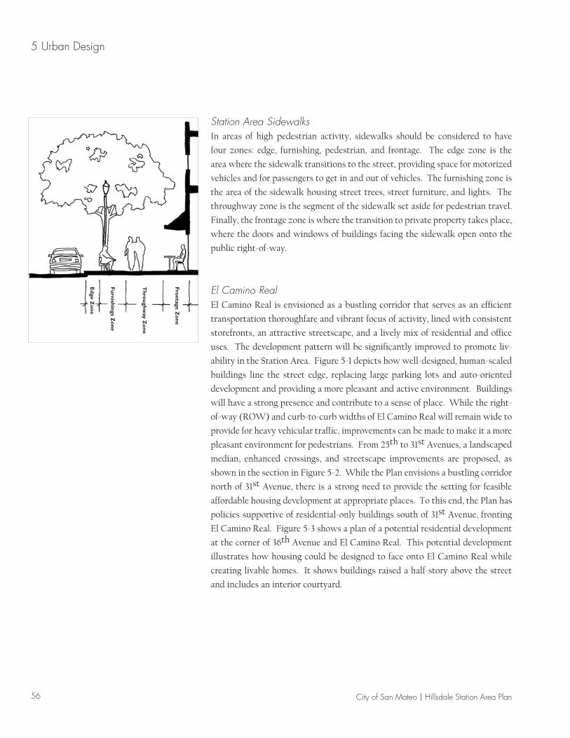
Station Area SidewalksIn areas of high pedestrian activity, sidewalks should be considered to have
four zones: edge, furnishing, pedestrian, and frontage. The edge zone is the
area where the sidewalk transitions to the street, providing space for motorized
vehicles and for passengers to get in and out of vehicles. The furnishing zone is
the area of the sidewalk housing street trees, street furniture, and lights. The
throughway zone is the segment of the sidewalk set aside for pedestrian travel.
Finally, the frontage zone is where the transition to private property takes place,
where the doors and windows of buildings facing the sidewalk open onto the
public right-of-way.
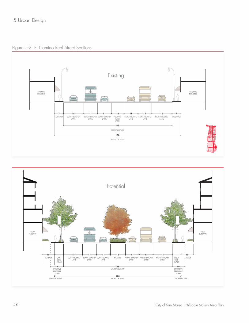
El Camino RealEl Camino Real is envisioned as a bustling corridor that serves as an efficient
transportation thoroughfare and vibrant focus of activity, lined with consistent
storefronts, an attractive streetscape, and a lively mix of residential and office
uses. The development pattern will be significantly improved to promote liv-
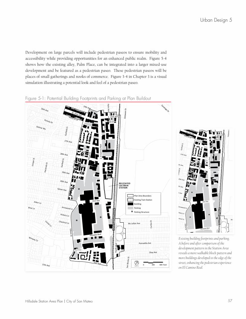
ability in the Station Area. Figure 5-1 depicts how well-designed, human-scaled
buildings line the street edge, replacing large parking lots and auto-oriented
development and providing a more pleasant and active environment. Buildings
will have a strong presence and contribute to a sense of place. While the right-
of-way (ROW) and curb-to-curb widths of El Camino Real will remain wide to
provide for heavy vehicular traffic, improvements can be made to make it a more
pleasant environment for pedestrians. From 25th to 31st Avenues, a landscaped
median, enhanced crossings, and streetscape improvements are proposed, as
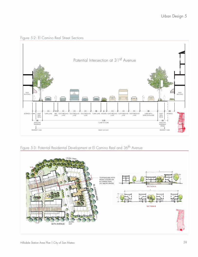
shown in the section in Figure 5-2. While the Plan envisions a bustling corridor
north of 31st Avenue, there is a strong need to provide the setting for feasible
affordable housing development at appropriate places. To this end, the Plan has
policies supportive of residential-only buildings south of 31st Avenue, fronting
El Camino Real. Figure 5-3 shows a plan of a potential residential development
at the corner of 36th Avenue and El Camino Real. This potential development
illustrates how housing could be designed to face onto El Camino Real while
creating livable homes. It shows buildings raised a half-story above the street
and includes an interior courtyard.
Edge Z
one
Furnishings Z
one
Thro
ughway Z
one
Frontage Z
one
57Hillsdale Station Area Plan | City of San Mateo
Urban Design 5
Hac
iend
a St
Flor
es S
t
Hillsdale Blvd
S. E
l Cam
ino
Real
36th Ave
31st Ave
28th Ave
27th Ave
Edison St
29th Ave
Otay Ave
30th Ave
37th Ave
Curti
ss S
t
Palm Pl
Louise Ln
26th AveW. 25th Ave
Sylvan Ave
Poinsettia Ave
Mc Lellan Ave
Portola Dr
24th Ave
Briar Ln
Juni
per S
t
Paci
fic B
lvd
Arbor Ln
Del
awar
e St
Delmar Wy
Mary Lu Ln
Lula Belle Ln
Gar
field
Ct
Palm Ave
Saratoga Dr
Palm Ct
Gar
field
St
Winway Cir
Chestnut Ln
Hickory Ln
Arrowood Ln
San
Beni
to S
t
E. 25th Ave
Edis
on S
t
Plan Area Boundary
Existing Train Station
Building
Parking
Plan Area Boundary
Existing Train Station
Building
Parking
**
*
0 300 600 FeetN O R T H
RELOCATEDCALTRAINSTATION
Plan Area Boundary
Existing Train Station
Building
Parking
Parking Structure*
Figure 5-1: Potential Building Footprints and Parking at Plan Buildout
Hac
iend
a St
Flor
es S
t
Hillsdale Blvd
S. E
l Cam
ino
Real
36th Ave
31st Ave
28th Ave
27th Ave
Edison St
29th Ave
Otay Ave
30th Ave
37th Ave
Curti
ss S
t
Palm Pl
Louise Ln
26th AveW. 25th Ave
Sylvan Ave
Poinsettia Ave
Mc Lellan Ave
Portola Dr
24th Ave
Briar Ln
Juni
per S
t
Paci
fic B
lvd
Arbor Ln
Del
awar
e St
Delmar Wy
Mary Lu Ln
Lula Belle Ln
Gar
field
Ct
Palm Ave
Saratoga Dr
Palm Ct
Gar
field
St
Winway Cir
Chestnut Ln
Hickory Ln
Arrowood Ln
San
Beni
to S
t
E. 25th Ave
Edis
on S
t
Plan Area Boundary
Existing Train Station
Building
Parking
**
*
Existing building footprints and parking. A before and after comparison of the development pattern in the Station Area reveals a more walkable block-pattern and more buildings developed to the edge of the street, enhancing the pedestrian experience on El Camino Real.
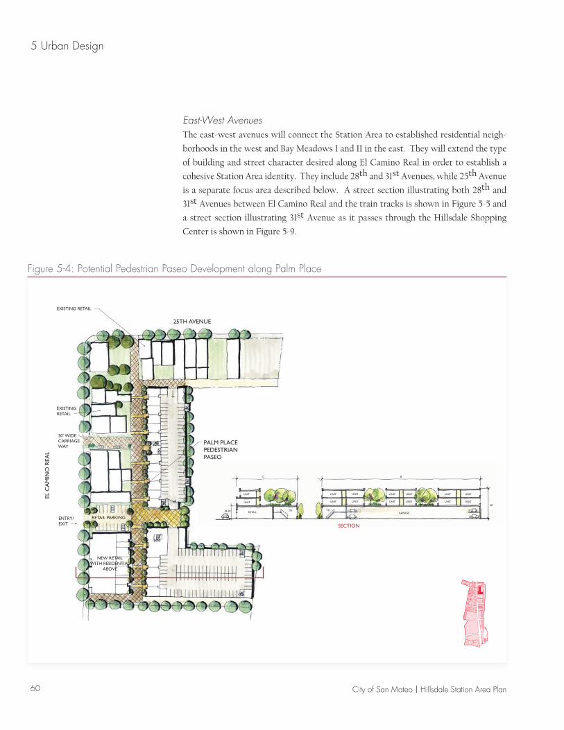
Development on large parcels will include pedestrian paseos to ensure mobility and
accessibility while providing opportunities for an enhanced public realm. Figure 5-4
shows how the existing alley, Palm Place, can be integrated into a larger mixed-use
development and be featured as a pedestrian paseo. These pedestrian paseos will be
places of small gatherings and nooks of commerce. Figure 3-4 in Chapter 3 is a visual
simulation illustrating a potential look and feel of a pedestrian paseo.
58 City of San Mateo | Hillsdale Station Area Plan
5 Urban Design
5 52EXIST SIDE-WALK
EXIST SIDE-WALK
SETBACKSETBACK
EFFECTIVE SIDEWALK
ZONE
EFFECTIVE SIDEWALK
ZONE
PROPERTY LINEPROPERTY LINE
8
115
EXIST SIDE-WALK
TURN LANE TURN LANE MEDIANBIKE LANE
EXIST SIDE-WALK
SETBACKLANE WITHWIDE SHOULDER
SETBACK
EFFECTIVE SIDEWALK
ZONE
EFFECTIVE SIDEWALK
PROPERTY LINEPROPERTY LINE
4
Potential
0 10 20 Feet
5 52EXIST SIDE-WALK
EXIST SIDE-WALK
SETBACKSETBACK
EFFECTIVE SIDEWALK
ZONE
EFFECTIVE SIDEWALK
ZONE
PROPERTY LINEPROPERTY LINEFigure 5-2: El Camino Real Street Sections
Existing
59Hillsdale Station Area Plan | City of San Mateo
Urban Design 5
Figure 5-2: El Camino Real Street Sections
5 52EXIST SIDE-WALK
EXIST SIDE-WALK
SETBACKSETBACK
EFFECTIVE SIDEWALK
ZONE
EFFECTIVE SIDEWALK
ZONE
PROPERTY LINEPROPERTY LINE
8
115
EXIST SIDE-WALK
TURN LANE TURN LANE MEDIANBIKE LANE
EXIST SIDE-WALK
SETBACKLANE WITHWIDE SHOULDER
SETBACK
EFFECTIVE SIDEWALK
ZONE
EFFECTIVE SIDEWALK
PROPERTY LINEPROPERTY LINE
4
Potential Intersection at 31st Avenue
MEWS
36TH AVENUE
40’ WIDE CREEK IMPROVEMENT ZONE
PEDESTRIAN/BIKE TRAIL
CREEKSIDEOPEN SPACE
MEWS
TH TH HTHT
THTHTH
UNIT
THTH
UNIT
UNITUNITUNITUNIT
GARAGE
COURTYARD
A
40’30’
30’
B
ENTRY/EXIT
TOWNHOUSES WITH FRONT STOOPS ONEL CAMINO REAL (4-5’ ABOVE GRADE)
SECTION B
SECTION A
B
A
A
B
LAUREL CREEK
EL CA
MIN
O R
EAL
Figure 5-3: Potential Residential Development at El Camino Real and 36th Avenue
60 City of San Mateo | Hillsdale Station Area Plan
5 Urban Design
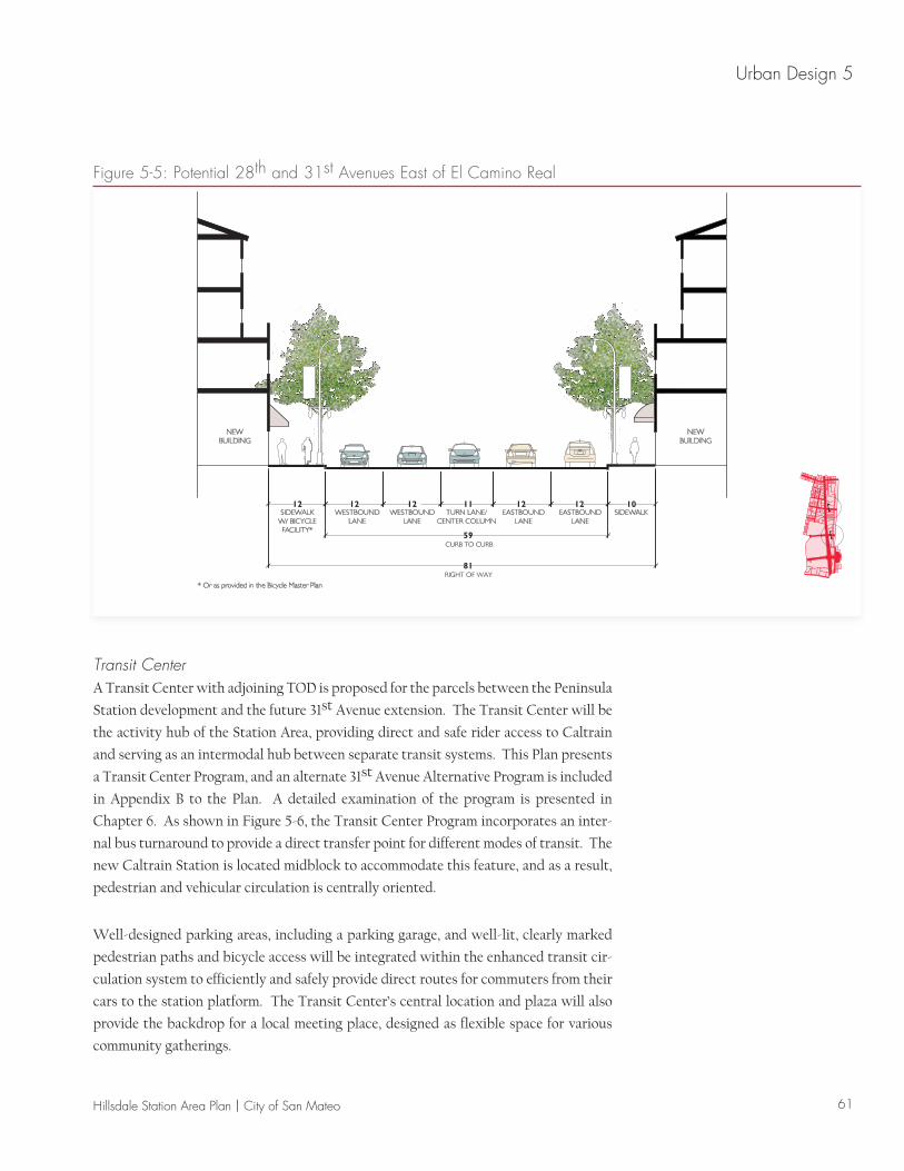
East-West AvenuesThe east-west avenues will connect the Station Area to established residential neigh-
borhoods in the west and Bay Meadows I and II in the east. They will extend the type
of building and street character desired along El Camino Real in order to establish a
cohesive Station Area identity. They include 28th and 31st Avenues, while 25th Avenue
is a separate focus area described below. A street section illustrating both 28th and
31st Avenues between El Camino Real and the train tracks is shown in Figure 5-5 and
a street section illustrating 31st Avenue as it passes through the Hillsdale Shopping
Center is shown in Figure 5-9.
THTHRETAIL
UNIT
UNIT
GARAGE
UNIT
UNIT
UNIT
UNIT
UNIT
UNIT
UNIT
UNIT
UNIT
UNIT
UNIT
UNIT50’
BC
30’ WIDECARRIAGEWAY
NEW RETAILWITH RESIDENTIAL
ABOVE
EXISTING RETAIL
25TH AVENUE
PALM PLACEPEDESTRIANPASEO
RETAIL PARKING
EL C
AM
INO
REA
L
ENTRY/EXIT
EXISTINGRETAIL
18-20’
SECTION
Figure 5-4: Potential Pedestrian Paseo Development along Palm Place
61Hillsdale Station Area Plan | City of San Mateo
Urban Design 5
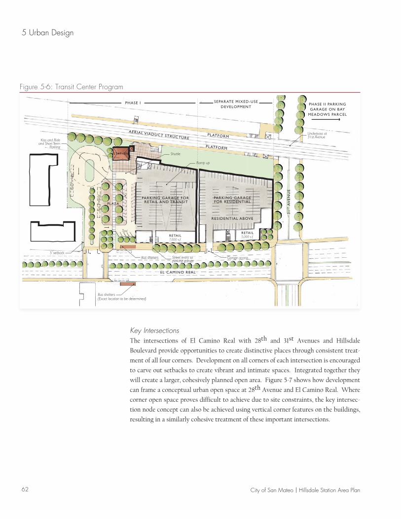
Transit CenterA Transit Center with adjoining TOD is proposed for the parcels between the Peninsula
Station development and the future 31st Avenue extension. The Transit Center will be
the activity hub of the Station Area, providing direct and safe rider access to Caltrain
and serving as an intermodal hub between separate transit systems. This Plan presents
a Transit Center Program, and an alternate 31st Avenue Alternative Program is included
in Appendix B to the Plan. A detailed examination of the program is presented in
Chapter 6. As shown in Figure 5-6, the Transit Center Program incorporates an inter-
nal bus turnaround to provide a direct transfer point for different modes of transit. The
new Caltrain Station is located midblock to accommodate this feature, and as a result,
pedestrian and vehicular circulation is centrally oriented.
Well-designed parking areas, including a parking garage, and well-lit, clearly marked
pedestrian paths and bicycle access will be integrated within the enhanced transit cir-
culation system to efficiently and safely provide direct routes for commuters from their
cars to the station platform. The Transit Center’s central location and plaza will also
provide the backdrop for a local meeting place, designed as flexible space for various
community gatherings.
0 10 20 Feet
SIDEWALKSIDEWALKW/ BICYCLEFACILITY*
* Or as provided in the Bicycle Master Plan
EASTBOUNDLANE
EASTBOUNDLANE
TURN LANE/CENTER COLUMN
WESTBOUNDLANE
WESTBOUNDLANE
NEWBUILDING
NEWBUILDING
121212 11
59
81
1212
Figure 5-5: Potential 28th and 31st Avenues East of El Camino Real
62 City of San Mateo | Hillsdale Station Area Plan
5 Urban Design
PARKING GARAGEFOR RESIDENTIAL
PARKING GARAGE FOR RETAIL AND TRANSIT
RESIDENTIAL ABOVE
PLATFORM
PLATFORM
AERIAL VIADUCT STRUCTURE
Ramp up
STATION Shuttle
Kiss and Rideand Short Term
Parking
PLAZA
Bus shelters(Exact location to be determined)
Bus shelters5’ setback
Street entry toparking garage
Garage access
RETAIL5,000 s.f.RETAIL
7,000 s.f.
Taxi
Bus
Park
ing
Bus
Park
ing
Underpass at 31st Avenue
PHASE I SEPARATE MIXED-USEDEVELOPMENT
EL CAMINO REAL
PHASE I I PARKING GARAGE ON BAY
MEADOWS PARCEL
31
ST A
VE
NU
E
Figure 5-6: Transit Center Program
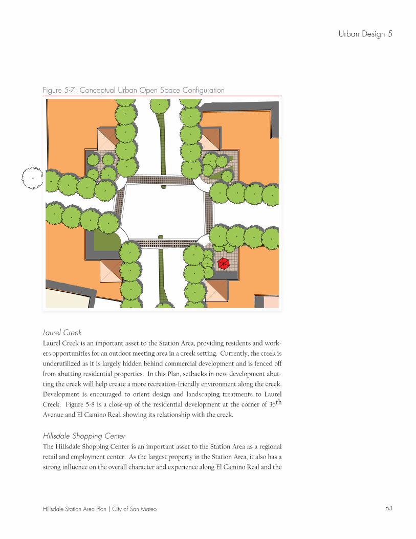
Key IntersectionsThe intersections of El Camino Real with 28th and 31st Avenues and Hillsdale
Boulevard provide opportunities to create distinctive places through consistent treat-
ment of all four corners. Development on all corners of each intersection is encouraged
to carve out setbacks to create vibrant and intimate spaces. Integrated together they
will create a larger, cohesively planned open area. Figure 5-7 shows how development
can frame a conceptual urban open space at 28th Avenue and El Camino Real. Where
corner open space proves difficult to achieve due to site constraints, the key intersec-
tion node concept can also be achieved using vertical corner features on the buildings,
resulting in a similarly cohesive treatment of these important intersections.
63Hillsdale Station Area Plan | City of San Mateo
Urban Design 5
Figure 5-7: Conceptual Urban Open Space Configuration
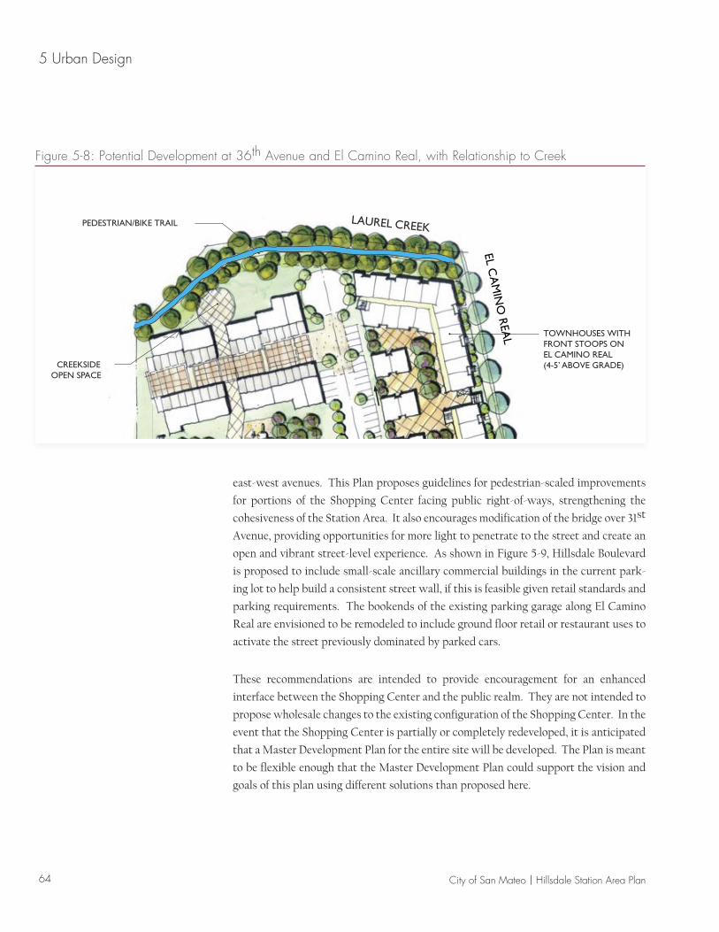
Laurel CreekLaurel Creek is an important asset to the Station Area, providing residents and work-
ers opportunities for an outdoor meeting area in a creek setting. Currently, the creek is
underutilized as it is largely hidden behind commercial development and is fenced off
from abutting residential properties. In this Plan, setbacks in new development abut-
ting the creek will help create a more recreation-friendly environment along the creek.
Development is encouraged to orient design and landscaping treatments to Laurel
Creek. Figure 5-8 is a close-up of the residential development at the corner of 36th
Avenue and El Camino Real, showing its relationship with the creek.
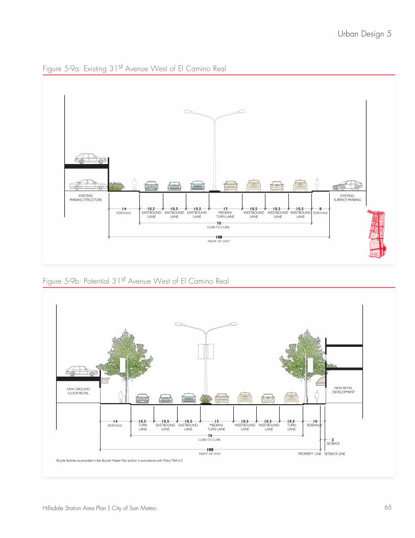
Hillsdale Shopping CenterThe Hillsdale Shopping Center is an important asset to the Station Area as a regional
retail and employment center. As the largest property in the Station Area, it also has a
strong influence on the overall character and experience along El Camino Real and the
64 City of San Mateo | Hillsdale Station Area Plan
5 Urban Design
east-west avenues. This Plan proposes guidelines for pedestrian-scaled improvements
for portions of the Shopping Center facing public right-of-ways, strengthening the
cohesiveness of the Station Area. It also encourages modification of the bridge over 31st
Avenue, providing opportunities for more light to penetrate to the street and create an
open and vibrant street-level experience. As shown in Figure 5-9, Hillsdale Boulevard
is proposed to include small-scale ancillary commercial buildings in the current park-
ing lot to help build a consistent street wall, if this is feasible given retail standards and
parking requirements. The bookends of the existing parking garage along El Camino
Real are envisioned to be remodeled to include ground floor retail or restaurant uses to
activate the street previously dominated by parked cars.
These recommendations are intended to provide encouragement for an enhanced
interface between the Shopping Center and the public realm. They are not intended to
propose wholesale changes to the existing configuration of the Shopping Center. In the
event that the Shopping Center is partially or completely redeveloped, it is anticipated
that a Master Development Plan for the entire site will be developed. The Plan is meant
to be flexible enough that the Master Development Plan could support the vision and
goals of this plan using different solutions than proposed here.
36TH AVENUE
PEDESTRIAN/BIKE TRAIL
CREEKSIDEOPEN SPACE
TOWNHOUSES WITH FRONT STOOPS ONEL CAMINO REAL (4-5’ ABOVE GRADE)
LAUREL CREEKEL C
AM
INO
REA
L
Figure 5-8: Potential Development at 36th Avenue and El Camino Real, with Relationship to Creek
65Hillsdale Station Area Plan | City of San Mateo
Urban Design 5
0 10 20 Feet
WESTBOUNDLANE
TURNLANE
SIDEWALK
SETBACK2
PROPERTY LINE SETBACK LINE
WESTBOUNDLANE
MEDIAN/TURN LANE
EASTBOUNDLANE
EASTBOUNDLANE
TURNLANE
Bicycle facilities as provided in the Bicycle Master Plan and/or in accordance with Policy TRA-5.3
NEW RETAILDEVELOPMENT
NEW GROUNDFLOOR RETAIL
Figure 5-9b: Potential 31st Avenue West of El Camino Real
0 10 20 Feet
WESTBOUNDLANE
WESTBOUNDLANE
WESTBOUNDLANE
MEDIAN/TURN LANE
EASTBOUNDLANE
EASTBOUNDLANE
EASTBOUNDLANE
EXISTINGSURFACE PARKING
EXISTINGPARKING STRUCTURE
Figure 5-9a: Existing 31st Avenue West of El Camino Real


![Elm Street Garage Urban Design Peer Review Documents/Elm Street Garage...Section 5 [urban design element] TIF Urban Design Guidelines Part III, Part IV [city center] Policy References](https://static.fdocuments.us/doc/165x107/5e89f183be814b74e573e0ee/elm-street-garage-urban-design-peer-review-documentselm-street-garage-section.jpg)