Updated Julian Community Plan
63
Part X Julian Community Plan San Diego County General Plan Adopted December 16, 1976 GPA 76-03 October 2010 Chapter 1 – Julian Community Plan Statement of Intent...............................................1 Introduction...........................................................2 Chapter 2 – The Plan Conservation Element .........................................8 Open Space Element..........................................17 Public Safety Element.........................................21 Scenic Highways Element..................................32 Land Use Element..............................................36 Housing Element................................................38 Public Facilities Element.....................................41 Chapter 3 – Julian Historic District..........................................53 Policy Code Explanation.......................................................60
Transcript of Updated Julian Community Plan

Part X
Julian Community Plan San Diego County General Plan
Adopted December 16, 1976
GPA 76-03
October 2010
Chapter 1 – Julian Community Plan
Statement of Intent...............................................1 Introduction...........................................................2
Chapter 2 – The Plan Conservation Element .........................................8 Open Space Element..........................................17 Public Safety Element.........................................21 Scenic Highways Element..................................32 Land Use Element..............................................36 Housing Element................................................38 Public Facilities Element.....................................41
Chapter 3 – Julian Historic District..........................................53 Policy Code Explanation.......................................................60

This page is intentionally left blank

TABLE OF CONTENTS
JULIAN COMMUNITY PLAN
PAGE CHAPTER 1 - JULIAN COMMUNITY PLAN STATEMENT OF INTENT ..................................................................................................... 1 INTRODUCTION ................................................................................................................... 2 CHAPTER 2 - THE PLAN CONSERVATION .................................................................................................................. 8 OPEN SPACE ..................................................................................................................... 18 PUBLIC SAFETY, FACILITIES AND SERVICES ................................................................ 21 SCENIC HIGHWAYS .......................................................................................................... 31 LAND USE .......................................................................................................................... 36 HOUSING ........................................................................................................................... 38 PUBLIC FACILITIES ........................................................................................................... 41 CHAPTER 3 - JULIAN HISTORIC DISTRICT ........................................................................... 53 APPENDIX MAPS .................................................................................................................... 58 POLICY CODE EXPLANATION .......................................................................................... 61

1
Figure 1: Julian Community Planning Area
CHAPTER 1 JULIAN COMMUNITY PLAN
STATEMENT OF INTENT A goal is a purpose or ultimate end towards which effort is directed. It represents a value to be sought which is general and timeless. A policy is a principle which guides the allocation of County resources towards prescribed outcomes consistent with the goals. The goals which follow reflect a thoughtful analysis of the Julian area and are a statement by the citizens and the Board of Supervisors as to the kind of total living environment that should be achieved. These goals are not a plan, they are not regulations, nor do they substitute for detailed study of current problems. They are intended to give direction to detailed planning studies which will result in definitive methods, programs, and recommendations for reaching these goals to the greatest extent possible. It is recognized that legal and economic limitations that presently exist may hinder the complete attainment of these goals. The fact that the goals may not be completely achieved should in no way hinder every effort to achieve them to the greatest extent possible.

2
There are elevenseven elements of the General Plan: Regional Land Use, Housing, CirculationMobility, Safety, Seismic Safety, Scenic Highways, Open Space, Recreation, Noise, Conservation and Energy.Open Space (combined) and Noise. These subject areas provide the basic structure by which this community plan is organized. Each chapter of the plan represents a subject area which coincides with an adopted element of the General Plan. The purpose of addressing these elements within this plan is to ensure that the goals and policies formulated by the Community will be compatible with those found in the General Plan, or, if conflicts exist, they can be readily identified and reconciled. In addition, some policies found in the General Plan elements can be more relevant for one community than for others, and further elaboration or refinement may be appropriate in one case while in another the existing policies might be adequate. The policies contained in this community plan should be regarded as application of broad General Plan policies which are designed to fit the specific or unique circumstances existing in the individual communities. Where the existing element adequately addresses an individual community’s situation, the subject area may be omitted or a notation to reference the element may be included so that the adopted goals and policies relating to the subject area may be taken into account.

3
INTRODUCTION The Community Plan Area (CPA) of Julian is located between Volcan Mountain and the Cuyamaca Mountains shown on Figure 2 at the end of this section. State Highway 78/79 serves as Julian’s Main Street and a principle travel route to the desert from metropolitan San Diego which lies 60 miles to the west. The Native America Kumeyaay tribe, the first inhabitants, lived in small, seasonal villages scattered throughout the area to avoid the desert heat of summer.. Being Nomadic, they traveled between the desert and coastal areas depending on the seasons. The discovery of gold in late 1860s brought gold-rush fame to these mountains and settlers to the newly-created town of Julian. In 1870, Julian's population was 300 with nearly 1500 people living in the Julian Mining District. However, the rush was short-lived and during the 1880s most of the mines closed. The population of Julian dropped to 100. Although several brief periods of mining revived interest in gold exploration, overall, mining had become too expensive to remain the mainstay of Julian's economy. Mining activities gave way to a variety of business efforts such as brick-making, lumbering, orchard agriculture and grazing. It was also at this time that visitors were drawn to the area by its beauty and Julian became known as a resort as well as a gold-rush town. The aura of gold-rush days has dimmed. Nevertheless, Julian continues to remind visitors of its colorful past by preserving the architectural authenticity of the area’s early years of settlement. Today, this area is known as the Julian Historical District. A thriving commercial base is provided by the sale of apples, apple products and gifts and souvenirs. Recently, facilities for overnight and weekend guests have been expanded and now make it possible to have an extended visit in the area. Camping in the surrounding mountains is also popular. Tourism, in its many forms, now provides a flourishing economic base for the Julian area and appears it will sustain the area for some time to come. The Planning Area will continue to maintain a rural lifestyle outside the Historic District. As a small rural community, Julian has been defined by its agriculturally based cattle grazing and fruit growing. Large ranches dividedelineate expanses of grazing land to grazing; smaller ranches often support orchards or wineries. Development pressure to change this scene is minimal; consequently, the undisturbed natural charm of the area will remain virtually unchanged. The 2010 SANDAG estimates for population and housing in the Julian Community Planning Area identify a population of 3,018 with a total of 1,710 housing units1
.
Population in the Planning Area is approximately 2800 today and is expected to reach nearly 4000 by the year 2005. When the first Community Plan was prepared in 1976, 1500 people lived in and around Julian. Increases in population have come slowly and it appears that this trend will continue. The proposed plan would reduce the ultimate population potential by more than 3000. However, commercial acreages will be increased in Julian and in Wynola to accommodate and encourage tourist trade. Finally, this new plan will recognize the beauty and environmental sensitivity of Volcan Mountain and establish it as a Resource Conservation Area (RCA). Development within the RCA will be closely scrutinized by the Planning Group to minimize the impacts of development. Integrating a rural lifestyle with the desire to expand commercial activities
1 SANDAG Profile Warehouse — http://profilewarehouse.sandag.org/profiles/est/cocpa1922est.pdf, August 2010

4
will be a challenge. A way of accomplishing this is to ensure that development is well designed and compatible with the natural and historical features that make Julian unique. This is especially true because of the limited water resources in the Plan Area (See Map on Page 3). Due to its elevation and mountainous topography, Julian is somewhat isolated from the rest of San Diego County. People from the neighboring communities of Santa Ysabel, Cuyamaca, Warner Springs, Mesa Grande, Banner and Shelter Valley use the community facilities and share in the endeavors of agriculture, tourism and public events. Julian relies on larger neighboring communities for major services and products. Due to minimal public transportation the community of Julian depends primarily on private automobiles and the use of highways 78 and 79 to access outside areas. At approximately 4200 feet of elevation, Julian enjoys all four distinct seasons and is a tourist destination to see the spring greenery and flowers, to hike and camp in the cooler summer air, to witness fall colors, and to play in the winter snow. The areas diverse biology supports a multitude of wildlife in pine-oak forest, chaparral covered hills, and grassy meadows. Julian can be calm and it can also be buffeted with high winds from both the east and west. Temperature can be over 100 degrees and can fall below 10 degrees, annual rain (including snow) ranges from 15 to 50 inches. In spite of possible extremes, most of the time, the weather is delightful. Julian has several distinct residential districts interspersed with single family houses on large acreages. The community is served by three school districts (Julian Elementary, Julian High School, and Spencer Valley) which are supplemented by the Eagle Peak Charter School and the Ray Redding Continuation School. There is a post office, county public library, town hall, museum, Women’s Club, Triangle Club, Lion’s Club, American Legion Post and a public cemetery. Recreational needs are addressed at several regional and community parks, including church camps, YMCA, Boy Scout and Girls Scout camps, Camp Fire Girls, and private campgrounds open to the public. Churches in the area include a Catholic Church, Methodist church, Mormon Church and other non-denominational churches. Also nearby are two Catholic Missions in Santa Ysabel and Warner Springs. The public sewer system is limited to the town site of Julian and the remainder of the community uses on-site septic systems to dispose of waste. The town site of Julian and several outlying residential areas are served by water districts whose supply is dependent on wells. The remainder of the residents rely on private wells and pipe systems. Well recharge is dependent on seasonal rain and snow fall. Annual and multi-year draught, combined with seasonal Santa Ana winds, creates severe fire hazards in the Julian area and there is a possibility of seismic damage occurring because of the proximity to the Elsinore earthquake fault. Julian is fortunate to have several agencies available to deal with emergencies and catastrophes, among them: A County Sheriff substation, Highway Patrol office, an ambulance service, CAL FIRE station, volunteer fire station, several US Forest Service stations, Caltrans and county road stations and a health clinic. Hospital care and trauma centers are accessed by ambulance and life flight services. Julian is a part of the Palomar/Pomerado Hospital District, approximately one hour distant by car.

5
Julian’s large commercial cattle ranches and fruit orchards are gradually being replaced. The trend towards cottage industries, home based internet businesses, bed and breakfast establishments and small wineries are some of the endeavors. For the most part, the businesses in town are geared for the tourist trade and a substantial number of people in the community commute to larger areas for work. The overall community is made up of retirees, people who live and work in the community, people who live and commute to work and part-time residents. Rapid population growth is not expected to be an issue

6
COMMUNITY VISION Planning for a balanced community and a healthy environment for all forms of life.

7

8
CHAPTER 2
THE PLAN The Julian Rural Village Boundary is shown on Figure 3 located in the appendix. ENVIRONMENTAL MANAGEMENT GENERAL GOAL ENCOURAGE A CONTINUING RURAL ATMOSPHERE BY PLANNING FOR A BALANCED ECOLOGICAL COMMUNITY AND A HEALTHY ENVIRONMENT FOR ALL FORMS OF LIFE. POLICIES AND RECOMMENDATIONS 1. Minimize negative impacts of development on the community and on the natural
resources of the area. (GEN) 2. Encourage property owners to avail themselves of legislation and private means
to retain natural resources and open space. Included could be agricultural preserves, open space easements, habitat preserves, land trusts, and scenic easements. (GEN)
3. Promote maintenance and , preservation and management of forested areas.
Encourage vegetation management and planting of young trees. RegulatoryProject Planning review shall attempt to protect forested areas during project review. (PP)
4. Grading should Require grading to be designed to protect the natural terrain and
minimize visual impacts. (PP) 5. Encourage the design of fuel breaks, shaded when possible, to follow natural
contours wherever possible. Brush removal is encouraged for fire protectio 6. Encourage local input to all environmental impact reports. (GEN) 7. Encourage preservation of areas with rare, unique or endangered wildlife and
plants, and archaeological sites of historic, scientific and educational value. (PP) 8. Encourage strict enforcement of regulations governing the use of off-road
vehicles. New subdivisions should consider the potential impacts produced by off-road vehicles. (PP)
9. Discourage noise, lighting, and signs that detract from and are not consistent
with the historic and rural atmosphere. The regulatoryproject planning process shall consider these potential impacts during project review. (PP)
10. Discourage off-premise advertising and signs that detract from and are not
consistent with the historic and rural atmosphere. AestheticVisual impacts shall be reviewed during the regulatoryproject planning process. (PP)

9
11. Encourage the conservation of natural resources and recycling of all reusable products. Potential impacts in these areas of concern should be reviewed in the regulatoryproject planning process. (PP)
12. Encourage the preservation of the historical character of the region. Any new
mining activity should be controlled to minimize environmental impacts. (PP) 13. Encourage the retention of natural stream channels and farm ponds. Encourage
only those uses compatible with potential flooding such as agriculture, parks, and recreation, riding and hiking trails, and other open space activities in floodplain areas. Limit all private buildings and construction from areas subject to recurring major flooding. (PP)
14. Promote those recreational activities and encourage those transportation means
which conserve resources and minimize pollution. (PP) 15. Encourage the locating and preserving of historic buildings and sites. (PP) CONSERVATION GENERAL GOAL ENSURE THAT THERE IS CAREFUL MANAGEMENT OF ENVIRONMENTAL RESOURCES IN THE AREA IN ORDER TO PREVENT WASTEFUL EXPLOITATION OR DEGRADATION OF THOSE RESOURCES AND TO MAINTAIN THEM FOR FUTURE NEEDS. FINDINGS Conservation may be defined as the planned management, preparation, and wise utilization of natural resources. Because of the local significance of these resources within the planning area, conservation is the main thrust of the Julian Community Plan. Julian possesses landforms of great scenic beauty which, in their natural state, provide habitat for a rich variety of plants and animals. POLICIES AND RECOMMENDATIONS: Recommend a Resource Conservation Area be created for the south- facing- to- -west facing slopes of that portion of Volcan Mountain in the Plan Area. A description of the area'sarea’s resources follows. (PP) VOLCAN MOUNTAIN RESOURCE CONSERVATION AREA Volcan Mountain, which is located in the northeast corner of the Plan Area, rises 1,000 feet above the Country Townrural village of Julian. The base of the mountain is bordered by Banner Creek which flows south-eastward into Banner Canyon. Tall oaks, sycamores and poplars, and a lush riparian habitat line the seasonal stream. The steeply ascending canyon slopes are covered with thick stands of chaparral interspersed with grasslands that give way to a ridge-top woodland of Incense Cedar, pines, firs and oaks, and mountain meadows.
10
The lower, more easterly slopes support a desert-transition community of creosote scrub.chaparral. The path of the Elsinore Fault crosses the southern base of the mountain generally following the course of Banner Canyon and Banner Creek. Protection of the well-developed riparian habitat, the steep and highly erodible slopes and the canyon walls through which the Fault passes is urged. Likewise the majestic beauty of the mixed evergreen forest which is comprised of unusually large specimens should be conserved. Sightings have been reported of the rarely seen Round-Leaved Boykinia (Boykinia rotundifolia Parry), the Golden Fairy Lantern Lily (Calochortus amabilis Purdy) and the endemic Humboldt Lily (Lillium humboldtill var. Bloomerianum) and indicate the potential of a rich botanical presence. The diversity of plant communities on Volcan Mountain provides foraging and nesting habitat to over 100 species of birds ranging from ducks and geese, to the sensitive spotted owl in the coniferous forest along with the colorful warblers and the ever-present juncos, chickadees and nuthatches. Over the grasslands golden eagles, kestrels and kites have been observed. The desert scrub and mesquite provide habitat for the cactus wren, the burrowing owl and the phainopepla. Habitat protection is essential to assure the continued presence of such a variety of birds. Volcan Mountain’s great size (20 square miles) dominates the Julian area. It can be seen from almost any vantage point in the community. Its peaceful, silent beauty derives from the interplay of constantly changing shades of green produced by the component woodland and chaparral species growing on the steep slopes. Views from the mountain top are equally breathtaking. On clear days, broad vistas of the desert and the ocean unfold before the viewer. Volcan Mountain is held in very special regard by the Julian community as an area of exceptional beauty an area worthy of preservation for the benefit of generations to come. For at least 1,000 years, Kumeyaay Indians occupied Volcan Mountain. Permanent and summer villages were strategically placed in canyons associated with Banner Canyon, Santa Ysabel Creek, and Dan Price Creek. Specialized food processing, religious observance, and hunting sites were located on ridge lines, terraces, and mesas such as Simmons and Ferguson Flat. Historically, mining, ranching, and lumber activity occurred in the Banner Creek and Volcan Mountain area. Mine shafts, ore crushers, stamp mills, and home sites remain as archaeological ruins and features. These and other landmarks have high historic and archaeological value. POLICIES AND RECOMMENDATIONS 1. Historic and prehistoric archaeological sites located within Volcan RCAs shall be
evaluated for Historic Landmark Status under Ordinance 7105 and if qualified, shall be designated and rezoned in accordance with Section 5700 of the Zoning Ordinance. (PP)
2. Unique archaeological resources as defined in the County of San Diego
Archaeology/History ProceduresGuidelines for Determining Significance: Cultural Resources and Archaeological Historic Resources, located within Volcan RCAs shall be preserved in protective open space easements and may be capped with

11
topsoil where threatened by vandalism, and recorded at the Regional Office of the State Historic Preservation Office. (PP)
3. Sensitive biological resources, including habitat and declining plant and animal
species, shall be protected by open space easements, buffers and the use of “D” Designators in accordance with the County's Biological Guidelines. County’s Resources Protection Ordinance. (PP)
4. Because of the high aesthetic quality of Volcan Mountain and the special regard
in which it is held, development must be sensitively designed to alter as little of the Mountain’s façade as possible. All cuts and fills shall be minimized to the extent possible, no reflective roofing material shall be allowed. All lighting shall be shielded and shall not extend above the horizontal nor be directly visible from the surrounding properties. (PP)
WATER GOAL ENSURE THAT ADEQUATE WATER SUPPLIES WILL BE AVAILABLE FOR THE LAND USES ESTABLISHED BY THIS COMMUNITY PLAN. Water is the single most limiting natural resource for the future well-being of the people of Julian. Residents rely solely on groundwater and local wells for their water supply. This groundwater availability is limited due to the presence of granitic rock over most of the planning area. If overdrafting (mining) of water takes place over too long a period in excess of recharge, groundwater will either physically disappear or become too expensive to pump. San Diego County studies indicate that many areas are not overdrawing their aquifers. The number of existing legal lots in some portions of the planning area, if developed, could exceed the long term groundwater availability in those locations. If this occurs, transfer of water will be necessary. For these reasons, responsible land use decision-making in the Julian area will require groundwater analysis prior to any major new development. It is possible to generalize on the ability of various-sized lots to meet the long-term groundwater requirements of an average single-family house. This generalization is called “relative safety rating”. Relative safety ratings are based on the reserve capacity of groundwater in storage needed to sustain a single-family house during a 15 year drought; and the time required to recharge the groundwater system prior to a second 15 year drought. The average level lot size which generally can be considered “safe” in Julian is five acres. Safe is defined as 45 or more years reserve capacity. The lot can sustain a third 15 year drought without a period of wet years to recharge the groundwater systems. However, under some conditions, smaller lots could be “safe” since the average annual groundwater recharge rate is approximately the same as average consumption use by a single family. Based on this analysis, about 5,280 homes can be accommodated yielding an ultimate population ceiling of approximately 14,250 residents. If additional water sources are identified at a later date, these figures would require revision. These are average

12
statistics, indicating that theoretically there is adequate groundwater in the planning area to support 14,250 people. But the Julian population is concentrated in a few neighborhoods rather than dispersed evenly across the community. Therefore, some areas with parcels larger than eight acres will be necessary to offset areas with smaller sized lots. In any event, transfers of water would be necessary to supply a population of 14,250 people. Transfer of water within the planning area does not imply importation of water which does not appear to be feasible. While the Julian Rtownsiteural Village is served by a modern sewer plant, on-site sewage disposal utilizing septic tanks is generally an effective means of filtering pollutants out of effluent re-entering the groundwater system. If septic tanks proliferate and failures become common, groundwater could become contaminated. FINDINGS Domestic water supplies in the Julian Planning Area are derived solely from groundwater. Groundwater in the Julian area is a limited resource. The overall residential density in the Julian Community Plan Land Use Elementsection could accommodate one dwelling unit per five acres based upon estimated groundwater availability. POLICIES AND RECOMMENDATION 1. Groundwater levels should be monitored in the public water system in the
planning area. Monitoring should be concentrated in area of population concentration. (DPW)
2. Cumulative effects of new development should be carefully regulated and the
quality of groundwater constantly monitoredevaluated. (DPW) 3. Groundwater recharge activities should be increased by retaining and building
agricultural ponds and other water bodies to increase infiltration. (GEN) 4. Impact analysis of installation of new sewage treatment plants or significant
expansion of service should address potential loss of groundwater recharge resulting from conversion of septic tanks. (PP, DPW)
5. Cumulative effects of numerous septic tanks on water quality should be
monitored. [W] 65. Water districts, companies, and similar entities should be encouraged to
coordinate and cooperate. (GEN) 76. Water districts should develop short and long range plans. (GEN)

13
VEGETATION AND WILDLIFE GOAL PREVENT THE UNNECESSARY ALTERATION OF THE NATURAL LANDSCAPE AND WILDLIFE HABITAT WITHIN THE PLAN AREA. FINDINGS Of the eight plant communities discussed in the Julian Basic Data Report, threefour of them represent significant natural resources – meadows, woodland, and woodland--grass. and forest. Meadows are uncommon habitat types in arid San Diego County and may support rare and endangered plants. The planning area contains 609 acres of meadows, most of which are used for agriculture. Limited data exist on the status of wildlife. Officially recognized rare or endangered species of flora and fauna are known to exist in the planning area. At least eighteen species of wildlife in the planning area are known to have depleted or declining populations. Mule deer and mountain lions exist in the Julian area. Several species of pine beetles have caused varying amounts of damage to native pine trees; these species could cause sporadic damage to forest. Golden Spotted Oak Borers have infested local oaks and have caused varying amounts of damage. Research is needed into the threat and management of this new pest. Residential development potentially decreases native wildlife, with some exceptions. The Julian Community Planning Area contains several unique natural habitats of regional significance, including meadows, forested areas, and riparian woodland habitats, some of which support rare and endangered plant species. The diversity and uniqueness of the habitats result in part from the community’s location at the transition between two very different climatic and topographic environments. The Banner Grade area in particular exhibits varied changes in vegetable cover making this a valuable area for study of changing faunal populations. This area has a significant and diverse population of wildlife. If habitat areas are disturbed, significant alterations in animal populations may result. Failure to manage vegetation on public and private lands, increases fire hazard and has potential for long term damage to forest and woodlands. POLICIES AND RECOMMENDATIONS 1. Indiscriminate grading and removal of natural vegetation should be minimized.
Cumulative effects of habitat disturbance are especially significant and should be addressed during evaluation of environmental impacts of discretionary proposals. (PP)
14
2. Recommend that owners of public and private lands manage vegetation to decrease fire hazard. (PA)
ARCHAEOLOGY AND HISTORY GOAL PRESERVE AND ENHANCE EXISTING ARCHAEOLOGICAL RESOURCES AND PROVIDE ADEQUATE PROTECTION FOR THOSE SITES THAT ARE, AS YET, UNDISCOVERED. FINDINGS Julian has a long history of human habitation from Indian times through the nineteenth-century gold rush to the present. Indians lived throughout the planning area when early Spanish and Mexican explorers passed through. Due to the nature of early Indian technology, certain areas within the Julian Community (particularly those on high ground near running water and oak groves) have a high potential for significant archaeological sites. Mining days in Julian are an integral part of nineteenth-century California history. The Julian townsite was laid out in the 1870s to house miners, and an architectural style evolved from the early buildings and many original buildings remain in use today. The Julian area was previously occupied by the Kumeyaay or Diegueno people, until displaced during the 19th century by Europeans. The Kumeyaay lived in fixed villages by seasons, but traveled to special resource camps during the year. Riparian and southern oak woodland plant communities served as rich food resource areas and centers for habitation. Rock outcrops in or around oak woodland areas were frequently used as grinding sites. Heise Park was found to contain several temporary camps and milling stations. The site of the previous Girl Scout Camp, Camp Winaka, apparently contains an historical Kumeyaay Village site. Known archaeological sites and areas of high potential for archaeological sites have been identified within the planning area. Julian contains an extensive and well-preserved history dating back over one hundred years. Many buildings remain standing in Julian from the mining days and should be preserved. The Julian townsiterural village is a County Historic District and was officially registered as a California Historical Landmark #412 on November 15, 1942; however, it is not yet listed on the National Register.

15
POLICIES AND RECOMMENDATIONS Location of potential and known sites of archaeological significance should be delineated as Archaeological Resource Conservation Areas. Wherever an environmental analysis is required by the Planning and Environmental Review Board (PERB), archaeological surveys within these conservation areas would aid in protection of the archaeological history of previous cultures. (PA) MINERALS GOAL ENCOURAGE THE JUDICIOUS USE OF MINERAL RESOURCES WITHIN THE JULIAN PLAN AREA. FINDINGS Gold is the primary valuable mineral known to exist in the planning area and its presence was a major factor influencing community development. A nickel deposit has been located in one mine. Usable building materials are scarce. Rock, sand, and gravel deposits are small and scattered, but Julian schist might be used as a decorative stone. POLICY AND RECOMMENDATIONS The Bureau of Land Management is encouraged to retain its lands where mineral deposits or mining claims occur. (GEN) FOREST CONSERVATION GOAL NEW DEVELOPMENTS SHALL BE DESIGNED SO AS TO PROTECT TIMBER RESOURCES TO THE MAXIMUM EXTENT POSSIBLE. FINDINGS Forest resources in Julian are of value primarily for aesthetics and for firewood. Large scale logging does not occur. POLICIES AND RECOMMENDATIONS 1. Forest resources should be protected through regulatoryproject planning review
(GEN, PP) 2. Selective cutting and , regeneration mayand fuel management should be
encouraged for reasons of aesthetics, wildlife management, fire protection and good forestry practices. (PP)
NOISE GOAL ENCOURAGE NOISE REDUCTION TO PRESERVE THE QUIET RURAL ENVIRONMENT OF THE PLAN AREA; SUPPORT REGULATORY MITIGATION OF NOISE IMPACTS ALONG THE MAIN THOROUGHFARES, HIGHWAYS 78 AND 79.

16
FINDINGS Noise is a significant environmental problem in the Julian Planning Area. The noise sources are localized along Highway 78 and 79 and noise levels are expected to reach significant proportions during the life of the planEvery person is entitled to an environment in which noise is not detrimental to one’s life, health or enjoyment of property. The peace and quiet that Julian residents and visitors enjoy is an asset to our community. The management of sound is a concern in Julian; the altitude and irregular open topography allows sound to carry extensive distances. The sources of noise are varied and primarily include traffic, aircraft, public and private gatherings, animals, agricultural and construction activities. The ambient sound level is higher in certain areas, particularly on holidays and weekends, because of permitted special activities which support tourism and the local economy. POLICIES AND RECOMMENDATIONS Specific or generalized impacts of mitigating measures are adequately addressed in the County Noise Element and environmental impact reports on proposed projects. (GEN, PP) AIR QUALITY GOAL DISCOURAGE THE LOCAL PRODUCTION OF AIR-POLLUTING EMISSIONS IN THE PLAN AREA. FINDINGS Julian is a rural community with a small population dispersed over a wide area. As such, it is probably one of the communities within the County least affected by regional air quality problems. Julian’s air quality is largely determined by emission sources in the surrounding areas, especially to the west. To a lesser extent this air quality is affected by weekend tourist traffic. The contribution of local resident activities is probably only a minor factor by comparison. Most of the factors which determine Julian’s air quality are not within the community’s power to influence. Nevertheless, there are things the community can do in the future to improve both the local and regional air quality situations. POLICIES AND RECOMMENDATIONS 1. Land uses should be integrated to allow residents ready access to a variety of
small scale commercial activities. (DPLU) 2. Group transportation should be encouraged where economically feasible. (PP) 3. Prescribed burning of brush in rural communities such as Julian should be
accommodated, despite negative impacts on air quality, in order to reduce fire hazard. (GEN)
17
OPEN SPACE The Open Space Elementsection identifies and describes the open space uses in the Julian community and contains policies to protect these open spaces. It is intended that the policies contained herein will more specifically detail the open space uses and policies pertaining to the Julian CPA. (See the Julian Community Plan Open Space Map, Figure 3.) Categories of Open Space Open space can be defined as any parcel or area of land or water which is unimproved and devoted to any open-space use that includes the preservation of natural resources, managed production of resources, outdoor recreation, agriculture including grazing, or the protection of public health and safety. The term open space is not synonymous with open space easement. The following categories of open space provide the basic framework by which open space preservation might be implemented. This elementsection incorporates existing park and recreational development in the Julian area, identifies environmental features, analyzes their significance and specifies areas suitable for open space protection. Managed Open Space — Natural flora and fauna with unique or representative vegetative and wildlife features, areas containing seismic hazard, outdoor and recreational areas, floodplains, and historic sites are included in this category. The following areas are designated as managed open space: 1. Cleveland National Forest lands 2. Bureau of Land Management lands 3. County Parks 4. Elsinore Fault 5. Floodplains 6. Historic Sites 74. State Parks Functional Open Space — Agricultural lands, scenic corridors and areas of steep terrain are included in this category. The following areas are designated as functional open space: 1. Agricultural lands as designated in the Land Use ElementAgricultural lands which
includes, grazing, orchards, vineyards and other crops.
2. Scenic corridors as designated in the Scenic Highway ElementAreas of steep terrain in excess of 25% slope.
3. Land within the Williamson’s Act, including grazing, orchards, vineyards, and other crops.

18
Figure 3: Julian Community Plan Open Space Map
19
OPEN SPACE GOAL ENCOURAGE THE PRESERVATION AND CAREFUL MANAGEMENT OF OPEN SPACE AND IN ADDITION ENCOURAGE AGRICULTURE PROPERTY TO REMAIN IN THE WILLIAMSON ACT. FINDINGS Over 90% of the planning area is undeveloped. Some of this land is in agricultural preserves. Much of the undeveloped land is over 25% slope. Certain open space lands are in public ownership. These include: a. U.S. Forest Service b. Bureau of Land Management c. San Diego County d. Special Districts
e. State Parks Some open space areas have been developed for recreational purposes. These include: a. William Heise County Park b. The small picnic park at the Julian Museum c. The half-mile nature trail in Inaja Memorial Park.
d. Minimal improvements at the Community Service District property.
e. Jess Martin Park. f. Several non profit, church and private camps
Open space is the primary factor contributing to Julian’s rural character. Neighborhoods are well defined by large expanses of intervening unimproved areas of exceptional scenic beauty. Pressures to develop these resources or the locations where they exist are not as great in Julian as in other more accessible areas of the County. Demand is rising, however, and local open space is of sufficient high quality in the Julian area that protection is warranted. In preparing the Julian Community Plan Open Space Element for Juliansection, environmental factors were rated for their appropriateness as open space and integrated to produce a composite Open Space Suitability Map. These factors were rated for areas of high, medium, and low suitability for open space protection. POLICIES AND RECOMMENDATIONS 1. A variety of open space facilities should be protected to serve the needs of the
Julian Community. (GEN) 2. Cooperation between all levels of government and private organization should be
encouraged in the areas of management, conservation and protection of open space resources. (GEN)
3. Provisions should be made to ensure citizen input from all elements of the

20
community into the development, design and evaluation of recreation and open space facilities. (DPLU, DPR)
4. Land to be used for agricultural purposes, including grazing, should remain as
functional open space. (GEN)

21
PUBLIC SAFETY, FACILITIES AND SERVICES INTENT The Julian Public Safety Element is intended to reduce loss of life, injuries, damage to property and economic or social dislocations resulting from fire, flooding, geologic occurrences and crime. FIRE PREVENTION AND PROTECTION GOAL PROVIDE THE FACILITIES AND LEVEL OF SERVICE NECESSARY TO PROTECT THE RESIDENTS OF THE PLAN AREA. FINDINGS Fire hazard in the The Julian community is rated by the national insurance board as within one of the highest hazard level (10 on a scale of 10). It is within the area of highest fire danger areas in San Diego County. This high hazard rating is due to several factors: presence of dense and flammable vegetation The community is surrounded by large parcels of public owned land. During the last several decades prescribed burning, mechanical or chemical fuel modification and grazing have not been allowed on many public lands. This has contributed to dense brush growth, severe dry underbrush and very flammable vegetation. The vast vegetation, steepness of slope, dry and windy climate,s and the presence of people. The first three factors affect the size andSanta Ana winds cause a very rapid rate of fire spread of a fire, but the presence of people increase incidence of fire ignition. Portions of the planning area accommodate people but have no form of communications with emergency personnel. Within the planning area, fire hazards are somewhat greater in the Harrison Park area than near Spencer Valley. In the southeastern area, vegetation is thicker and dryer, water is more scarce, and the topography creates fire fanning conditions likened to a wind tunnel. By contrast, Wynola has more available water and orchards which function as fuel breaks. Although many fires have occurred over the years, flammable vegetation has grown back in the burned area in just a few years, and establishs a high fire-hazard level. Water is a primary fire fighting tool and is in short supply in the Julian Community Planning Area.area. Any form of water storage is desirable. Some conflict between ideal fire-safety standards and preservation of historical sites in the Julian townsite may arise. HistoricHistorical setbacks, alley widths and building materials in particular may cause problems. Recommendations for fire safety fall into in four categories: education and prevention, equipment, circulation and land use regulation. POLICIES AND RECOMMENDATIONS: (Education and Prevention) 11. Degree of fire hazard and precautionary measures should be well publicized
22
throughout the planning area, with special attention to visitors. (GEN) 2. Control burning and (or) chemical or mechanical brush thinning should be used
on both public and private property to reduce fire hazard. (GEN) 3. Encourage the education of local, private and public property owners as to the
valuevalues of brush clearance, shaded fuelbreaks and compliance with County and State code is needed.
4. Camp operators shall be encouraged to identify the location of safety areas,
describe emergency escape routes and supervise fire drills. 5. Grazing of public and private lands is encouraged. (Equipment) 56. All forms of water storage should be encouraged, including: Agricultural ponds; Recreation ponds at public parks; Readily available water for fire fighting in subdivisions and public parks; and Exploration of mandatory reserves in tanks for neighborhood water distribution.
(PP) 67. All connections provided for fire fighting use in proposed discretionary permit
applications should provide for standardized hardware. (PP) 78. Coordination of all local fire fighting equipment and personnel should be
encouraged. (GEN) (Circulation) 8. All roads leading to occupied structures should be large enough to accommodate
emergency vehicles. 9. To promote access to hazardous areas, emergency easements should be
negotiated at appropriate intervals. 10. All road names and house numbers should be posted clearly to aid identification
in emergency situations. (GEN) 11. Trails should be laid out with some regard to fire safety and all trails should be
cleared. Similarly, regular stopping points on trails should be cleared and maintained. (GEN, DPR, DPW)
12. At least two access routes should be provided to new subdivisions, one of which
may be for emergency use only. (PP)

23
(Land Use Regulation) 13. All hazardous usesareas should be identified including the propane storage yard,
individual propane tanks, gas stations, and likely locations for outdoor operation of stationary machinery. These areas should be properly cleared and equipped with fire extinguishers. (GEN)
14. Fire prevention officials should continue to make recommendations forregarding
lot splits and subdivisions. (PP) 15. Shaded fuel breaks and other forms of vegetation management should be
encouraged to reduce fire hazard on both private and public lands. (PP) FLOOD SAFETY GOAL MINIMIZE FLOODING HAZARDS THROUGH CAREFUL PLANNING AND CONSTRUCTION FINDINGS Because the terrain in Julian is so rugged, flooding is an unlikely threat. Floodplains have been identified along major creek beds but are generally less than 300 foot wide bottoms of steep canyons. Many small, earthen dams exist in the planning area. They are generally located so that a rupture in the dike would allow water to disperse before any damage could be done. In researching potentially hazardous dams throughout San Diego County, the Office of Emergency Services identified no such structures in the Julian area. Small dams have beneficial effects on wildlife and groundwater. GEOLOGICAL HAZARDS SAFETY GOAL MINIMIZE GEOLOGICAL HAZARDS THROUGH CAREFUL PLANNING AND CONSTRUCTION. FINDINGS Landslides, erosion, and earthquakes constitute the primary geologic hazards. Most of the planning area is sited on stable bedrock, primarily granitic rock, and is resistant to landsliding. Topsoil erosion potential is high, however. The Elsinore Fault runs through Banner Canyon, about three miles from the townsiteRural Village. An earthquake having a magnitude of 7.6 on the Richter scale is estimated to occur somewhere along the Elsinore Fault Systemsystem at an average interval of 60 years. A seismic event of this magnitude can cause considerable damage to certain types of buildings in the Julian community. Large structures and inherently unstable soils which compound seismic hazard are uncommon in Julian, and the vast majority of existing

24
buildings are of wood frame construction flexible enough to withstand severe groundshaking. However, some of the historic buildings are expected tomay suffer major structural damage and, quite possibly, collapse. In the Julian Planning Area, an interim ordinance mandated byaccordance with the Alquist-Priolo Earthquake Fault Zoning Act, the County Seismic Safety Element will requirerequires geologic reportsinvestigations for all discretionary and ministerial permit applications which propose structures for human occupancy within the County-designated Elsinore Fault-Special Study Zone. Boundaries of the County-designated Elsinore Fault-Special Study Zone shall be coincident with the State Division of Mines and Geology Elsinore Fault-Special Study Zone upon delineation by the State. CRIME SAFETY GOAL ENCOURAGE CRIME REDUCTION THROUGH PERSONAL SAFETY MEASURES FINDINGS Crime rates in Julian are relatively low and most crime seems to be committed by visitors to the area, but crime rates probably will increase with population growth. Primary offenses are burglary and theft. The large number of vacation homes, usually vacant mid-week and in winter, are ready targets for such activity. Large parcel sizes also contribute to burglary potential, as most homes are not visible from streets or neighboring yards. Residents in this rural community seem to favor residential seclusion, even at the expense of hampered crime detection. POLICIES AND RECOMMENDATIONS 1. Encourage the installation of anti--intrusion hardware is encouraged. Dawn.
(PP) 1. Discourage dawn to dusk or similar exterior illumination is not encouragedin the
CPA. (PP)

25
CIRCULATION MOBILITY GENERAL GOAL DEVELOP A CONVENIENTCONVIENT, SAFE, AND BALANCEDEFFICIENT CIRCULATION SYSTEM FOR A VARIETY OF TRANSPORTATION NEEDS IN THE JULIAN AREA WHILE MAINTAINING THE RURAL, HISTORIC AND NATURAL CHARACTER OF THE AREA. INTENT The Circulation ElementThe Mobility section identifies and analyzes circulation needs in the Julian Community community and contains policies and recommendations to meet those needs. The Julian Circulation ElementCommunity Plan Mobility section was drafted after careful consideration of the General Plan CirculationMobility Element and responds to needs and policies identified in the Countywide document. The Julian Mobility Element road network is provided in the County General Plan Mobility Element Network Appendix as Figure M-A-9. The Circulation Element describes the general location and extent of existing and proposed major thoroughfares, transportation routes, terminals and facilities, all correlated with the land use element. ROADS GOAL ENCOURAGE A SMOOTH FLOW OF TRAFFIC THROUGHOUT THE PLAN AREA. FINDINGS The Julian CPA is served by a road network consisting of two-lane State Routes and local County roads. All the area’s centers of population have access to this network. The area lends itself to private motor vehicle transportation because of its remoteness and low population density. Turnouts are necessary in order to ensure a safe and smooth flow of traffic. Excluding local traffic, 90% of through trips are regional trips, of which 60% are for recreational purposes. Planned roads on the present County CirculationMobility Element for the Julian Area are in excess of need based balance with the planned land uses in Julian as designated on traffic projectionsthe Land Use Map. Regional traffic projections beyond l995 indicate the need for an additional north-south road to supplement SR79 if additional lanes are not provided on SR79. There are two primary routes linking metropolitan San Diego with the planning area: State Route 78/79 from the west (78 from the west and 79 from the north merge in Santa Ysabel) and State Route 79 from Interstate 8, via Cuyamaca, from the south. Additionally, State Route 78 provides access to Julian, via Banner Canyon, from the

26
Anza Borrego desert to the east (see Map on page 23). Principle County roads in Julian are Wynola Road, Pine Hills Road, Frisius Road, and Farmer Road, Manzanita Road, Harrison Park Road and Whispering Pines Road. Smaller paved collector streets serve residential neighborhoods, as do unpaved public and private roads. Snow removal service is provided on State Routes and County maintained roads. Curbs and gutters are neither necessary nor desired by residents. On State Route 78, at Main and Washington, the greater traffic counts are a result of locally generated traffic. At the present time, State Routes 78 and 79 are operating at well below capacity. Accident rates, as shown below are below the State-wide average. Accident Data – 1986 Total Fatal Injury State Route 78 – Number of Accidents 47 0 3 State Route 79 – Number of Accidents 6 0 3 Accident Rates State Route 78: 1.94 Accidents Per Million Vehicle Miles. State Route 79: 1.62 Accidents Per Million Vehicle Miles. State-Wide Average: 3.27 Accidents Per Million Vehicle Miles. SOURCE: CALTRANS Traffic in the CPA is generated primarily from nearby metropolitan areas, as current traffic data illustrate. The currently adopted County CirculationMobility Element proposes an ultimate identifies a system of prime arterials and majortwo-lane Light Collector roads through the planning area in excess of foreseeable demand. Principle components of the County wide element are displayed on the accompanying map.. Although designated as two-lane roads, the Mobility Element reserves sufficient right-of-way for State Highways to construct as four-lane roads or to construct turnout and passing lanes. The Julian Circulation Element Mobility section forecasts reasonable local and regional demand through the life of this plan and a few years beyond. Short and long range recommendations are based upon these projections. Short Range Issues—Secondary access is a major concern in populated areas such as subdivisions and regional parks. Under emergency conditions, evacuations of residents and access by emergency vehicles are restricted where only one road exists. This situation is particularly serious for the residents living off Harrison Park Road and in Julian Pines. Traffic on steeper portions of the state highways through Julian is congested because of slow moving vehicles. Desirability of turnout and passing lanesadditional turnouts has

27
been identified in the policies and recommendations. Due to topography and road alignment, several potential view sites have been identified. On a clear evening, lights from metropolitan San Diego are visible from above the Convair campground.Pine crest Campground. Banner GradeGrande provides several views of changing vegetation, geologic phenomena, historic sites and distant vistasview sites. Direct residential access is provided to state roads through the Julian Planning Area with many driveways adjoining these routes. As traffic increases on these highways,cars vehicles transitioning to and from a growing number of access points will add to the traffic hazards, congestion and accidents. Long Range Issues -- Increases in regional recreational travel and local growth are reflected in local traffic patterns. Over the ten-year period, from l975 to l985, average daily traffic counts have increased on an average of 89% on Highway 78, and increased 62% on Highway 79. Projections by the County and State CALTRANS foresee further increases by 2005. POLICIES AND RECOMMENDATIONS: 1. Encourage additional turnouts of sufficient length with well marked signage and
left turn pockets only where warranted for safety on major roadways. 2. Where possible within existing right-of-ways with minimal environmental
disturbance, unpaved bicycle/pedestrian pathways, where feasible on rural mountain roads and light collectors should be considered.
3. Street lighting shall be restricted to major road junctions and only for safety
reasons. 4. Minimize urban improvements such as vertical berms, curbs, gutters, and
sidewalks to preserve the rural atmosphere of the community. 5. Encourage the retention of public transportation between the Julian Area and the
major population centers (Ramona, Escondido, San Diego and Borrego Springs). 6. Turning lanes are recommended at the following location:
a) Left turn lane from Highway 78/79 onto Wynola Road. b) Left turn lane from Highway 79 onto Harrison Park Road.
7. Encourage the paving of Lakeview Drive from Manzanita Drive to Royal. 8. Outdoor flood lights on or near highways and roads should be shielded or
directed so they are not hazardous to night drivers. 9. Traffic circulation problems in the Julian area should be worked on jointly by the
California Department of Transportation, County Planning Agencies, and the Julian Community Planning Group.

28
10. Any land division along State Highway 78 or 79 which would create two or more lots of four acres or less should provide common access to the highways or otherwise satisfy the engineering and safety requirements of Caltrans and the County.
11. Design parking so as to discourage cars from backing out onto a highway. 12. Blend roads into the natural terrain and minimize urban improvements such as
vertical berms, curbs, gutters, streetlights and sidewalks to preserve the rural atmosphere of the community consistent with the Julian Right of Way Standards. Roads should follow natural contours, avoid grid pattern streets, and minimize cuts and fills and the disturbance of rock outcroppings and trees wherever possible.
13 Identified road or safety issues shall be resolved in a timely manner. New traffic
concerns shall be addressed and resolved as soon as possible. 1. Study a by-pass routing of Highway 78/79 around downtown Julian. [DPLU,
DPW]
2. Provide off-street parking in downtown Julian. [DPLU, DPW]
3. Provide passing lanes, turnouts, and left turn pockets on major roadways. [R]
4. Provide turnouts and parking facilities on major roadways at scenic view points. [GEN]
5. Establish bicycle/pedestrian lanes on rural mountain roads and light collectors where feasible within existing rights-of-way. [R]
6. Street lighting shall be restricted to major road junctions to improve night driving safety. [R, DPW]
7. Design roads to follow natural contours, avoid grid pattern streets, minimize cuts and fills and the disturbance of natural rock-outcroppings and trees wherever possible. [R, DPW]
8. Minimize urban improvements such as vertical berms, curbs, gutters, and sidewalks to preserve the rural atmosphere of the community. [R, DPW]
9. Encourage retention of public transportation between the Julian Area and the major population centers (Ramona, Escondido, San Diego, and Borrego Springs). [R, DPW]
10. Increase sight-distances, improve shoulder to facilitate emergency parking, and other major realignments should be undertaken by the State along portions of Highway 78 and 79 to improve traffic flow, promote safety, and reduce traffic accidents. [GEN]
11. 11. Passing lanes and turnouts are necessary. They should be well marked and of adequate length and located to ensure easy traffic merging. Areas to install snow chains could be expanded for this purpose. [GEN, DPW]
12. The unpaved shoulder on Highway 79 .1 mile south of Inspiration Point should be improved as a potential view site. [GEN]
13. Turning lanes are recommended at the following locations: [GEN]
a. A. Deceleration lanes onto Pine Hills Road.

29
b. B. Left turn lane from Highway 78 into Julian High School.
c. C. Left turn lane from Highway 78 onto Highway 79.
d. D. Left turn lane from Highway 78/79 onto Wynola Road.
e. E. Left turn lane to Harrison Park.
14. It is recommended that localized access problems be resolved by residents and the appropriate governmental agencies. Emergency secondary routes and other identified problem areas are particularly important. [GEN, DPLU]
15. Outdoor floodlights on or near highways shall be shielded or directed so they are not hazardous to night drivers. [R]
16. As traffic flow through the townsite becomes hazardous or unreasonably congested, solutions to smoother circulation should be determined jointly by the California Department of Transportation, County Planning Agencies, and the Julian Community Planning Group. [GEN]
17. Any land division along State Highway 78 or 79 which would create two or more lots of four acres or less should provide common access to the highway or otherwise satisfy the engineering and safety requirements of CALTRANS and the County. [R]
18. Businesses locating along a state highway should coordinate the use of well-marked driveways. Provision of an entrance and exit which prevent cars from backing onto the highway would relieve potential congestion.
19. Blend roads into the natural terrain and minimize urban improvements such as vertical berms, curbs, gutters, street lights and sidewalks to preserve the rural atmosphere of the community.
TRAILS GOAL ALL PATHWAYS AND TRAILS SHALL PRESERVE THE SCENIC BEAUTY OF OUR ROADSIDES, NEIGHBORHOODS AND NATURAL ENVIRONMENT.ENCOURAGE THE CREATION AND MAINTENANCE OF A TRAIL SYSTEM THROUGH THE SCENIC PORTIONS OF THE PLAN AREA. FINDINGS 1. The creation of pathways would cause damage to the scenic beauty due to the
removal of hundreds of trees and cutting back the embankments along the roadways in the Julian Planning Area.
2. Staging areas would cause traffic congestion. These sites would require large
amounts of land to accommodate equestrian trailer rigs. Our concerns are the noise, dust, trash and lack of public restroom facilities created by such an area.
3. As there are thousands of acres of public land surrounding the Julian Planning
Area, any new trails shall be located on these public lands. This would provide a safe and scenic riding and hiking experience.
Residents of Julian express great interest in being able to enjoy their vicinity at close range - on foot, on horseback or by bicycle. In addition, Julian's recreational orientation

30
provides further demand for local trails. Currently no official public trails exist through the planning area except for those internal to Heise park and Inaja Monument Park, although the California Riding and Hiking Trail is located immediately to the east of the planning area. This trail is considered a temporary alignment to be formalized as the Pacific Crest Trail. To develop the Julian trails system, commonly used existing routes were inventoried. These routes primarily included the following destinations: 1. Julian Townsite 2. Santa Ysabel 3. Heise Park 4. Cuyamaca State Park 5. Eagle Peak Road to El Capitan Reservoir 6. Pacific Crest Trail/California Riding and Hiking Trail The adopted County Bicycle Element designates a bicycle path from Santa Ysabel along 78/79 through Julian and south along 79 to Lake Cuyamaca. Another leg of the trail goes to Banner via Highway 78. Steep terrain and thick vegetation are major determinants of riding and hiking trail alignments. Many local landowners have allowed riders to cross their property by special arrangement, but access by the general public remains limited. POLICIES AND RECOMMENDATIONS 1. When a new trail or pathway is proposed, the Julian trails subcommittee will go to
the site to determine the feasibility of putting a trail or pathway in that location and then make a recommendation to the JCPG.
2. The county will take no extractions to obtain land for trails or pathways. 3. When a pathway is proposed along a roadside, the JCPG will poll the abutting
property owners to determine whether to support or oppose the pathway. Polling results will be in writing and be made public (public input also requested).
4. When feasible and determined to be safe, a pathway width less than 10 feet may
be considered. 5. There will be no pathways connecting the Cuyamaca area with the Volcan
Mountain area. 6. There will be no staging areas in the Julian Community Planning Area unless
approved by the JCPG. 7. The JCPG can recommend the temporary or permanent closure of any trail or
pathway that proves to be a nuisance (such as dust, noise, trash, use by motorized vehicles, etc.).
1. Major road alignments or widenings should include provisions for paved shoulders with bicycle lanes. [R, DPW]
2. Immediate improvement of a bike trail between the townsite and Julian schools,

31
by way of Cape Horn Road, should be negotiated to allow safe bicycle travel for children. [DPW]
3. Pine Hills Road and Frisius Road to Heise Park should be made safe for bicycles as soon as possible. [GEN]
4. A safe bicycle route should be provided from Kentwood and Whispering Pines to the Julian schools. [DPLU, P]
5. Care should be taken when designing trails to allow cattle full use of pastures, prevent them from wandering off property, and protect them from mischief by trail users. [GEN]
6. Use of trails should be carefully regulated. Signing should indicate public trails, caution against trespassing, and convey high fire danger warnings and precautions. Closing trails when fire hazard is high should be considered. [DPW]
7. Proposed trails should cross public lands for the greatest portion of their length. [DPLU, P]

32
SCENIC HIGHWAYS GOAL DUE TO ZONING REGULATIONS AND RESTRICTIONS THERE IS NO NEED TO FURTHER IMPLEMENT DESIGNATED SCENIC HIGHWAYS IN THE JULIAN PLANNING AREA.RECOGNITION THAT THE MAJOR ROADS AND HIGHWAYS PROVIDE VIEWS OF SCENIC VISTAS THROUGHOUT THE PLAN AREA. INTENT The Julian Scenic Highway Element was prepared to ensure enhanced enjoyment and utilization of scenic resources in the planning area. The Julian Scenic Highway Element is intended to support the policies contained in the Scenic Highway Element of the General Plan. Policies and action programs contained herein will more specifically detail the scenic highway designations and policies pertaining to the Julian area. This Scenic Highway Element establishes interim measures to protect all scenic corridors in advance of official designation. Situated at the junction of three major travel routes through San Diego's back country, Julian is a natural destination for recreational drivers on recreational trips through the mountains, and for drivers heading into or out of the desert. The transition between two very different geographic zones - the coastal plain and foothills to the west and the desert to the east - creates added scenic interest as wooded slopes give way to spectacular vistas. FINDINGS All major roads through the Julian Planning Area are State Highways which meet the guidelines for official California scenic highways primary routes through the community in that they: o are through-roads linking major recreational and historic areas as well as joining
existing scenic corridors; o offer scenic vistas and pass through beautiful countryside; o are utilized for one day sightseeing. Julian displays scenic beauty unrivaled in most of San Diego County. People traveling through enjoy spectacular vistas of the desert and inland valleys. Changing seasons are evident as roads pass through wooded canyons, open meadows and grassy rolling hills. These scenic characteristics have made the planning area attractive for permanent residences and vacation homes. Because major development has occurred outside the visual corridors of main roads, the sensation of expansive open space remain unspoiled. Analysis of scenic characteristics in the planning area covered the following segments of the state highways: o State Highway 78 up Banner Canyon and along Wynola Road through steep
canyons, rolling hills and scenic agricultural lands. Highway 78 enters San Diego

33
County from Imperial County to the east and passes through Anza-Borrego Desert State Park, where l8.2 miles are already officially designated.
o State Highway 79 approaching the townsite from the south, winding along the
ridge line between forested or grassy hillsides and spectacular desert vistas. Highway 79 travels from Interstate 8 through scenic Cuyamaca State Park and passes the state owned vista site at Inspiration Point.
o State Highway 78/79 from the junction of 78 and 79 through the townsite to Santa
Ysabel. The view from the road alternates between enclosed wooded areas and wide open meadows, and includes opportunities for tourists to stop at roadside fruit stands. Highway 79 continues past Lake Henshaw to Warner Springs and 78 travels to Ramona and Escondido.
POLICIES AND RECOMMENDATIONS 1. Scenic highways should be implemented for these roads shown on the
accompanying map (see Map on page 32). [DPLU, P] 2. Buildings and structures shall be so designed and located on the site as to create
a harmonious relationship with surrounding development and the natural environment; [R]
3. Buildings, structures, and plant materials shall be constructed, installed, or
planted so as not to unnecessarily obstruct scenic views visible from the area: [R] 4. Potentially unsightly features shall be located so as to be inconspicuous from
streets, highways, public walkways, and surrounding properties, or effectively screened from view by planting and/or fences, walls, or grading; [R]
5. Insofar as feasible, natural topography, vegetation and scenic features of the site
shall be retained and incorporated into the proposed development; [R] 6. Any grading or earth moving operation in connection with the proposed
development shall be planned and executed so as to blend with the existing terrain both on and adjacent to the site, and vegetative cover shall be provided to hide scars on the land resulting from such operations. [R]
COMMUNITY DEVELOPMENT AGRICULTURE GOAL PROMOTE LONG-TERM AGRICULTURE IN THE JULIAN AREA. POLICIES AND RECOMMENDATIONS 1. Encourage agriculture, particularly fruit, tree farming,, orchards, vineyards and
livestock grazing to provide and conserve open space. (GEN, AWM)

34
2. The combination of agriculture with other activities shall be allowed to provide an economic advantage to agriculture in competing with the forces of urbanization. (GEN)
3. Urban sprawlLeapfrog development shall be discouraged in order to preserve
agricultural resources. (GEN) 4. Encourage the use of reclaimed water for irrigation. (PP) 5. Discourage nuisance--prone heavy agriculture such as large scale commercial
productions of poultry and swine. (P) RESIDENTIAL DEVELOPMENT GOAL ACCOMMODATE RESIDENTIAL DEVELOPMENT THAT WILL ENHANCE THE RURAL ATMOSPHERE AND QUALITY OF LIFE THAT IS SOUGHT BY THOSE WHO CHOOSE THE JULIAN AREA FOR THEIR PLACE OF RESIDENCE. POLICIES AND RECOMMENDATIONS: 1. Innovative land planning in Julian is essential to preserve the natural open space
(areas of visual impact, meadows, hillsides, forested areas, rock outcroppings, etc.). (P,PP)
2. Extensive or severe grading shall be prevented by tailoring development to the
character of the natural terrain. (PP) 3. Encourage a variety of housing types while maintaining and promoting a rural
residential atmosphere. (PP, ARB)
4. Groundwater concerns shall be a limiting factor to the approved density of mobile home parks, Policy 3.8 of the Land Use Element not withstanding. [R, W]
54. Encourage street planting of native vegetation, landscaping of private property,
and the placing of utilities underground in residential areas. (PP, ARB) 5. Groundwater concerns shall be a limiting factor to the approved density of
residential projects and property divisions.
6. Encourage the use of solar photo voltaic electric generators and solar heated water systems in all new residential developments.
7. Encourage external lighting to be directed downward. 5.8. Discourage all-night exterior lighting. COMMERCIAL DEVELOPMENT GOAL COMMERCIAL DEVELOPMENT AND ACTIVITY SHALL BE COMPATIBLE WITH THE RURAL AND HISTORICAL ENVIRONMENT, AND SHALL PROTECT THE QUALITY OF RESIDENTIAL LIVING, AND SHALL EXPAND WITHIN EXISTING ESTABLISHED

35
COMMERCIAL LAND USE PATTERNS WITHOUT EXTENDING EXISTING COMMERCIAL STRIPS. POLICIES AND ECOMMENDATIONS: 1. Commercial development shall locate in established commercially zoned areas
without extending that area. 2. New commercial building within the commercially designated areas shall be
required to provide adequate restroom facilities for customers. 3. Any new or changed use that would significantly increase the parking
requirement should not be permitted until the parking requirement is met. 4. Work with the County of San Diego to establish a mitigation bank for those
businesses that cannot meet the on site parking requirement. 5. Prohibit commercial development and activities that generate excessive noise. 6. Encourage controlled access to commercial uses to reduce traffic congestion, i.e.
delivery parking. 7. Encourage the creation of a bus parking area that could also accommodate
additional tourist vehicles. 8. All future commercial development, located outside the jurisdiction of the Julian
Architectural Review Board, shall compliment not only the site to be developed but also the surrounding areas and existing development. Appropriate landscaping, off street parking and other design criteria and standards shall be used to further this goal.
9. Encourage all commercial signs located outside the jurisdiction of the Julian ARB
to be limited in size, lighting and character and to blend into the rural atmosphere.
10. Encourage locally owned and operated businesses. 11. Discourage retail franchise-style business such as auto parts, fast food,
convenience, big box home furnishings etc. 12. Discourage the construction of sidewalks, curbs and gutters except as defined by
the Julian Community Right of Way Standards. 13. Prohibit off-site real estate signs.
1. Prohibit those commercial activities which generate visual unsightliness,
excessive noise, unpleasant odors, air pollution, health hazards, etc. [R] 2. Locate industrial and heavy commercial activities in one general area adequately
buffered and hidden from view. [R]

36
3. Prohibit clear cutting, large scale timber cutting, strip mining activities, high density development businesses, and any other enterprises that would use up or deface large areas of landscape. [R]
4. Allow small neighborhood convenience centers within or close to concentrated
residential areas, when it can be demonstrated that a need exists. [R, ARB] 5. Discourage installation of wind generators for the commercial generation of
power. [R] 6. All future commercial development, located outside the jurisdiction of the Julian
Architectural Review Board, shall complement not only the site to be developed but also the surrounding areas and existing development. Landscaping, off street parking and other design criteria and standards shall be used to further this goal. [R]
7. Commercial activities shall locate in already established areas. [R] 8. Allow the construction of sidewalks, curbs, and gutters only where essential in
commercial areas. [R] 9. Encourage controlled access to commercial uses to reduce traffic congestion.
[R] 10. Encourage all commercial signs to be limited in size, lighting, and character and
to blend into the rural atmosphere. [R] LAND USE LAND USE GOAL LAND USE WITHIN THE JULIAN COMMUNITY PLAN SHALL RETAIN AND IMPROVE THE HISTORIC AND RURAL CHARACTER OF THE COMMUNITY. FINDINGS The Julian Community Plan Land Use Map for Julian designates land uses which represent locations for residential, commercial, agricultural, and industrial use. Land use designations in the Julian Community Plan provide a low density development plan which reinforces the primary goal of retaining the historic and rural character of the community. RESIDENTIAL LAND USE within the Julian Planning Area is characterized by localized concentrations of homes into identifiable subdivisions, with scattered residential development between each subdivision. Within the subdivisions, a large number of potential building sites have been created, but the actual number of full-time residences is significantly smaller. SANDAG Housing estimates furnished by the San Diego County Department of Planning and Land Use, Economics and Demographics Section, indicate that Julian has 2,924 1,710 total housing units, 45approximately 27% of which are not

37
permanently occupied and , but are used as second homes2
.
COMMERCIAL LAND USE within the Julian Planning Area is located primarily in two areas, Wynola and the Historic District. There are also scattered commercial uses located throughout the planning area. Commercial use within the planning area is oriented toward providing convenience services, but relies more heavily on tourism as a major source of income. AGRICULTURAL LAND USE designations and zoning covers most of the Julian Community Planning Area. A large portion of the planning area is held in agricultural preserves. The major use within the agricultural preserves is cattle grazing. Other agricultural pursuits include horse breeding, tree crops, and wine making. RECREATION is a major land use within the Julian community. There are more than a dozen recreational parks and camps of a public, quasi--public and private nature within the planning area. Total aggregate area in parks and campgrounds is estimated to be approximately 1,300 acres. POLICIES AND RECOMMENDATIONS 1. All development/remodeling in the community shall preserve the rural qualities of
the area, minimize traffic congestion, and not adversely affect the natural environment. (PP, DPW)
2. Extensive, unsightly or severe grading for development, both private and public,
shall be prohibited. (PP, DPW) 3. All large development projects must prove groundwater adequacy and
availability, and shall not adversely impact the groundwater supply. (PP) 4. Large lot sizes are necessary in the agriculturally-zoned lands to maintain rural
character, protect steep slopes, and preserve and protect open space and agriculture where economically feasible. (PP)
5. All new commercial development shall provide undergrounding of utilities where
economically feasible and possible, landscaping, and off-street parking to assure visually attractive development. (PP, ARB) *2 SANDAG (2008)
6. Areas with rare, unique or endangered wildlife and plants shall be preserved. [R] 6.7. Exempt new development in the Julian Area from installing improvements that
detract from the rural and historic character of the community. Such detracting improvements include street lights, traffic signals, curbs, gutters, and sidewalks. (PP, ARB)
7.8 Mixed rural land uses such as commercial uses, cottage industries, residences,
agriculture, sale of farm-related products (not necessarily home-grown) shall be allowed. (PP)
2 SANDAG Profile Warehouse — http://profilewarehouse.sandag.org/profiles/est/cocpa1922est.pdf, August 2010
38
8.9 Site planning, as much as possible, should preserve the rural qualities of the area and minimize traffic congestion. (PP)
9.10 All new building design and plans in the commercially zoned area of Wynola shall
be reviewed by the Julian Community Planning Group for visual impact and other environmental concerns. (PP)
11. Study the feasibility of community design guidelines for the Wynola area. [GEN] HOUSING ENSURE THAT ADEQUATE, AFFORDABLE SHELTER IS PROVIDED FOR ALL RESIDENTS OF THE JULIAN PLAN AREA IN A WAY THAT IS CONSISTENT WITH ITS RURAL CHARACTER. INTENT The Julian Housing Elementsection inventories existing housing supply, analyzes population characteristics and demand, and identifies special housing needs. The Julian Housing Elementsection amplifies the County General Plan Housing Element by providing information on a local scale. It emphasizes aspects of the County-wide Housing Element most relevant to Julian. FINDINGS In general, Julian has no critical housing needs. It is expected that the private sector will continue to meet the demand in the future. Specific data regarding housing and demography are unavailable for the Julian CPA itself due to the configuration of census tract boundaries. Currently there are about 2,0001,710 dwelling units in the CPA, over 97% of which are single-family homes. Many units are old (29% built before 1949). There are enough parcels to house the projected population of 3,400 persons in the year 1995. Approximately 45-5027% of the dwelling units in the CPA are used as vacation homes. Most statistics available on housing and population characteristics in Julian are from the 1980 U.S. Census of Population and Housing. Julian lies in the southeast corner of Census Tract 209.01 and comprises about one-eighth of the area and over one-half the population of this tract. It is believed by County statisticians that the Julian CPA is representative of findings in Census Tract 209.01. Accommodating Future Demand Various public agencies have projected SANDAG projectsforecasts a 2030 population of

39
3,446growth to 3,400 permanent residents in 19953
. This represents a 2114% increase in the current permanent population. The General Plan land use map would accommodate approximately 600 additional housing units in the Julian Planning Area, which would house nearly 1,600 people. Therefore, there is more than sufficient capacity in the Julian CPA to accommodate the SANDAG forecast population for 2030. These new residents can be accommodated easily by the Land Use Plan.
Currently, only 1,100 of the 2,000dwelling units are occupied year round. At 2.54 persons per household, the current housing stock could house approximately 5,000 people. There exists about 1,950 vacant parcels in the Planning Area. Even if many of these are combined to create larger parcels, it is possible that these parcels alone could support double the current population. The Planning Area contains additional acreage beyond these 1,950 vacant residential parcels. In fact, were the community to be developed to the maximum allowed by the plan, approximately three times the projected population could be housed. The current ratio between permanent and vacation housing, also, can be accommodated in the future. (See Table 1.) A wide range of housing choices remain available through the Julian Land Use ElementCPA. POLICIES AND RECOMMENDATIONS 1. The rural character of the community should be retained while providing
adequate housing. 2. Rehabilitation of the existing older housing stock is desirable. 3. It is desirable that smaller, less expensive units be available within the Planning
Area.
3 SANDAG 2030 Population Forecast — http://profilewarehouse.sandag.org/profiles/fcst/cocpa1922fcst.pdf, February 2010
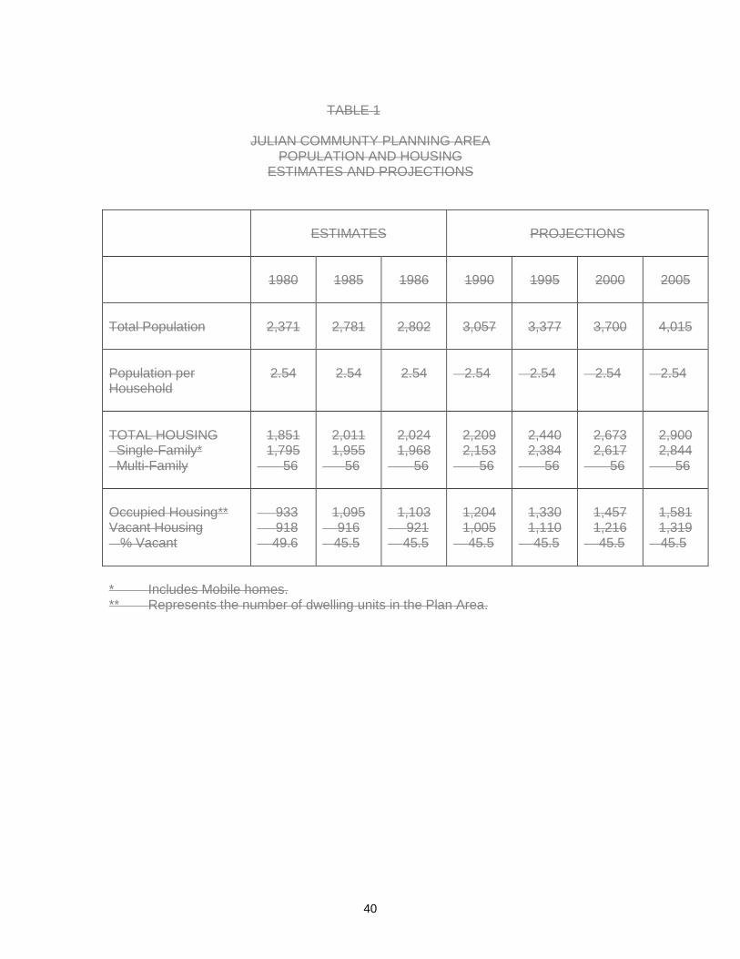
40
TABLE 1
JULIAN COMMUNTY PLANNING AREA
POPULATION AND HOUSING ESTIMATES AND PROJECTIONS
ESTIMATES
PROJECTIONS
1980
1985
1986
1990
1995
2000
2005
Total Population
2,371
2,781
2,802
3,057
3,377
3,700
4,015
Population per Household
2.54
2.54
2.54
2.54
2.54
2.54
2.54
TOTAL HOUSING Single-Family* Multi-Family
1,851 1,795
56
2,011 1,955
56
2,024 1,968
56
2,209 2,153
56
2,440 2,384
56
2,673 2,617
56
2,900 2,844
56
Occupied Housing** Vacant Housing % Vacant
933 918 49.6
1,095
916 45.5
1,103
921 45.5
1,204 1,005
45.5
1,330 1,110
45.5
1,457 1,216
45.5
1,581 1,319
45.5
* Includes Mobile homes. ** Represents the number of dwelling units in the Plan Area.

41
PUBLIC FACILITIES INTENT The Public Services and Utilities Element section was prepared to ensure proper coordination between population growth and service delivery. Julian is a rural community which neither expects nor receives an urban level of services. Even wWith a doubling of SANDAG forecasted 14 percent population projects for 2005,growth in the area, the community will not have a large enough population to warrant greatly improved services. This section addresses the following types of public services and utilities (see Figure 4). Schools Parks Sheriff Protection Fire Protection Health Care Facilities Library Water Liquid Waste Disposal Solid Waste Disposal Power Telephone Public Restrooms SCHOOLS GOAL ENCOURAGE THE PROVISION OF THE EDUCATIONAL AND RECREATIONAL FACILITIES NEEDED IN THE PLAN AREA. FINDINGS School enrollment in the Julian area has been remarkably stable in recent years. It should be noted that a doubling in local population will not necessarily double the number of school age children in the planning area. This is due to the large percentage of older and retired people who are moving to the community. Three schools serve the Julian Community, and it is expected that these will be sufficient to meet the needs of the local population for the life of the plan. The two largest schools, Julian Union Elementary School and Julian Union High School are located next to each other just east of the townsite.Rural Village. Both schools serve areas significantly larger than the planning area and both are operating below planned capacities. Enrollment projections for each district indicate that there will be more school children in each district than the current capacities can accommodate. The third school in the Julian Planning Area is Spencer Valley Elementary School. In the past the local schools have served as community centers. School yards are unlocked and buildings are available for community recreation and meetings with the consent of the school districts.
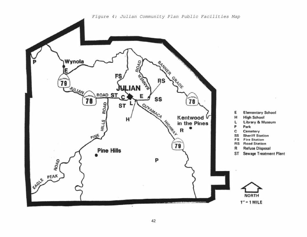
42
Figure 4: Julian Community Plan Public Facilities Map

43
POLICIES AND RECOMMENDATIONS Use of school sites as community centers is encouraged to continue in the future. (GEN) PARKS GOAL SUPPORT RECREATIONAL OPPORTUNITIES TO MEET COMMUNITY NEEDS FOR A BALANCED SYSTEM OF RECREATION FACILITIES AND SERVICES. FINDINGS: William Heise County Park, almost 1,000 acres of mountainous terrain, provides a wilderness experience to residents of the entire region. New Major facilities planned for the Park will be confined to the vicinity of existing facilities and Frisius Road. Plans for the park include additional overnight capacity, educational/nature interpretive facilities, and trail improvements. Other regional facilities are the small County Picnic area located adjacent to the Julian Museum and the Inaja day use picnic area located on U.S. Forest Service property in the Northwest corner of the Julian Planning Area. There does not appear to be a need to expand these facilities. At the present time no County affiliated community park is located within the Julian Community Planning Area.Jess Martin Park, located south of the rural village, is the only County operated park located in the Julian Community Planning area. The community park contains ball fields, a skateboard facility and picnic facilities. The Master Plan envisions basketball courts, walking/jogging path and additional family recreation areas. The Park is owned by the County and maintenance is provided by the County through a parcel assessment collected from property owners in the Planning Area. In the vicinity of the Town CenterRural Village, recreational facilities including a football field, baseball diamonds, tennis courts and a basketball court are available to the public on the grounds of the Julian Union Elementary School ( at the discretion of the School Board), and the Julian Union High School District. With the approval of the Julian Community Service District, property located behind the Frank Lane Memorial Arch on FarmerFarmers Road is open for public events. At the current adoptedBased on the County General Plan goal (Goal COS-21 in the Conservation and Open Space Element) standard of 15 acres per 1,000 population, Julian does not provide the recommended 42 acres of community park land for the recreational activities of the community. However, within the Julian Planning Area are located National Forest, Bureau of Land Management land, State Park property and County parks. Parks. Therefore, there is no need to allocate Park Lands Dedication Ordinance funds for the purchase of park land. There is a strong desire for well--developed community recreational facilities. Quasi--public and private organizations maintain camping and other recreational facilities within the planning area. POLICIES AND RECOMMENDATIONS

44
1. Planned improvements for Heise Park should be implemented in a manner that reduces impacts to surrounding properties. Wherever feasible, new facilities should be planned to be a minimum of 100 feet from adjacent property lines and should be designed so that bright shiny surfaces and lights are shielded from adjacent properties. (PP)
2. Private development near Heise Park should be implemented in a manner that reduces impacts to the park. Wherever feasible, new improvements should be planned to be a minimum of 100 feet from park property lines and should be designed such that bright or shiny surfaces and lights are shielded from Park property. Owners of private property adjacent to Heise Park are allowed to fence their boundaries. (PP)
3. Park Land Dedication Fund money shall be used on facilities appropriate for the
use of local residents. (DPR) 4. In recreational vehicle campgrounds operated for profit and in which the users of
such campgrounds purchase rights such as memberships, timeshare estate or timeshare use, it is necessary to ensure that community resources and facilities are not overloaded to an unacceptable degree. Therefore, the following guidelines shall apply to applications for establishing or expanding such membership recreational vehicle campgrounds within the Julian Community Plan area.
A. Any application for a Major Use Permit for an RV campground shall be
reviewed initially with respect to the stated goals of the Julian Community Plan. (PP)
B. Any application for a Major Use Permit for an RV campground shall consider the cumulative impact on the Community’s resources and facilities of: (PP)
1) the campground itself; 2) the community’s permanent population;
3) the large number of daytime visitors who do not stay overnight; C. The maximum number of all camping spaces, including overflow
permitted in any RV campground, shall not exceed: (PP)
1) 5 spaces per acre in areas zoned for a minimum lot size of less that 4 acres;
2) 2.5 spaces per acre in areas zoned for a minimum lot size of 4 acres;
3) 1.25 spaces per acre in areas zoned for a minimum lot size of 8 acres or greater.

45
D. The maximum number of camping spaces per RV campground and the density of camping spaces within an RV campground may be further limited by identified environmental or social impacts, or conflicts with the goals and objectives of the Julian Community plan. (PP)
E. The aggregate number of camping spaces permitted within the Julian
Planning Area shall be no more than 25% of the total permanent population of the area, with a maximum in the order of magnitude of 750 sites.(PP)
F. For the purposes of the policy, camping space means any site or area,
located within an campground, with (wet) or without (dry) hookups (electricity, sewer, and water) or with any one or more such hookups, upon which a recreational vehicle, and/or tent, and occupants may be located. A recreational vehicle and /or tent, located in an overflow area, shall be counted as occupying a camping space. (PP)
G. The RV campground plan shall be designed to minimize visual and noise
impacts on surrounding properties. (PP)
5. The following guidelines shall apply to public, quasi--public and private camps and campgrounds open to the public. ( PP)
A. The plans for any new campground or expanded campground
shall be reviewed initially with respect to the stated goals of the Julian Community Plan. ( PP )
B. Any campground plan shall consider the cumulative impact
on the community'scommunity’s resources and facilities of ( PP)
a) The campground itself; b) The community’s permanent population;
c) The large number of daytime visitors who do not stay overnight. C. The maximum number of all camping spaces, including overflow,
permitted in any campground shall not exceed: ( PP )
a) 5 spaces per acre in areas zoned for a minimum lot size of less than 4 acres:
b) 2.5 spaces per acre in areas zoned for a minimum lot size of 4 acres;
c) 1.25 spaces per acre in areas zoned for a minimum lot size of 8 acres or greater.
D. The maximum number of camping spaces per campground and the
density of camping spaces within a campground may be further limited by identified environmental or social impacts, or conflicts with the goals and objectives of the Julian Community Plan. (PP)
E. For the purposes of this policy, camping space means any site or area,

46
located within a campground, with (wet) or without (dry) hookups (electricity, sewer, and water) or with any one or more such hookups, upon which a recreational vehicle, and/or tent, and occupants may be located.
F. A recreational vehicle and/or tent, located in an overflow area, shall be
counted as occupying a camping space. (PP) FG. The campground plan shall be designed to minimize visual and noise
impacts on surrounding properties (PP)
6. School grounds should remain available for local recreational and community needs. (GEN, PP)
SHERIFF PROTECTION GOAL ENCOURAGE THE PROVISION OF SHERIFF PROTECTION REQUIRED TO MEET THE NEEDS OF THE PLAN AREA. FINDINGS The County Sheriff provides police protection and operates emergency ambulances in the Julian Community Planning Area. Using a typical average of one officer per 1,000 population, the five deputy sheriffs in Julian's Julian’s sheriff station are adequate. The sheriff station is a leased facility and is expected to remain on the present site. The facility does not have a holding cell for prisoners. Presently one of the two deputies on duty must transport prisoners immediately to the metropolitan area, a round-trip of almost three hours. This procedure leaves only one deputy on duty in the community. POLICIES AND RECOMMENDATIONS 1. Because seasonal influxes of tourists in Julian are due at least in part to the
presence of regional recreational facilities, the County of San Diego should provide any necessary additional deputies needed during peak tourist months. (GEN)
2. Law enforcement agencies should coordinate their efforts where feasible by
means such as joint use of the Julian Sheriff Station. (GEN) FIRE PROTECTION GOAL PROVIDE FIRE PROTECTION IN A TIMELY MANNER TO MEET THE COMMUNITY’S NEEDS. FINDINGS The Julian Community Plan Area is a region of extremely high fire potential. Structural fire protection is provided by the volunteer staffed Julian-Cuyamaca Fire

47
Protection District. Wildland fire protection during fire season is provided by the California Department of Forestry and Fire Protection and the U.S. Forest Service. The Pine Hills Mutual Water Company has obtained a loan from the U.S. Department of Agriculture for 1.5 million dollar system improvements that will include water filtration, reliable storage and water line replacement with added fire hydrants.
POLICIES AND RECOMMENDATIONS 1. Vegetation clearance and management around structures and fuel breaks to
protect subdivisions should be constructed and maintained. (PP) 2. Structures outside organized water service areas (districts, water companies,
etc.) should have adequate on--site above groundwater storage for fire fighting purposes, and these facilities should be equipped with fittings that permit easy connections to fire fighting apparatus. (PP)
3. Individual water service areas should be strongly encouraged to look into all
possible sources of funding for upgrading the local service system. (GEN) 4. The present standpipes in the town site should be upgraded to hydrants. [JCSD] 4.5. The concept of increasing volume by creating a water--delivery grid within the
townsiterural village should be pursued. An additionadditional main, to increase volume, should be installed in the townsite. [rural village. (JCSD)
6. The Pine Hills system should be upgraded. [PHMWC] 5.7. Harrison Park should install a water storage and delivery system. (GEN) 6.8. Storage and delivery systems in the Majestic Pines Water District are adequate.
However, storage volume is sometimes critically low. Majestic Pines needs to should ensure adequate water for fire protection is in storage at all times. [, whenever possible. (GEN)
9. Due to the large number of dumpster fires, a provision for a hydrant at the solid
waste bin site should be pursued. [DPW] HEALTH CARE GOAL PROVIDE HEALTH CARE SERVICES ADEQUATE TO MEET THE NEEDS OF THE PLAN AREA. FINDINGS Julian is located in Health Services Area 1115- Escondido and is part of the Northern San Diego County Hospital District. The District maintains two general, acute care hospitals, Palomar Hospital in Escondido, currently licensed to operate 300 acute-beds,

48
and Pomerado in Poway, currently licensed to operate 130 acute-beds. The total acute-bed capacity in the area is 430 although both hospitals are over one-half hour from Julian. An expansion program is current underway at Palomar Hospital. A satellite radiological service is located in Ramona. In 2008, medical services supporting the community consisted of the following:
• Resident medical professionals, include one family practioner, twopractitioners, dentists, and one chiropractor and physical therapists.
There is currently one organization that provides in-home nursing care. North County Health Services operates a clinic in Santa Ysabel, 7 miles west of the Julian Historic District.
• Emergency medical services isare provided by ambulances operated by the County Sheriff. This service is supplemented by emergency medical services provided by the Julian-Cuyamaca Fire Protection District. EMT and Paramedic levels of service are also provided
• Life Flight and Astrea provide aeromedical services for the area.
POLICIES AND RECOMMENDATIONS 1. DueEncourage continued funding for the emergency medical services, due to the
large proportion of emergency medical cases resulting from accidents on highways and the presence of a large number of tourists in the community the county should continue funding of the sheriff's ambulance and other emergency medical services. . (GEN)
2. Provision of additional medical services to the Julian area should be investigated,
including para-medical service. [GEN] LIBRARY GOAL PROVISION OF ADEQUATE SERVICES AND POSSIBLE STORAGE OF HISTORICAL MEMORABILIA FOR THE AREA. FINDINGS The Julian County Library is located in the townsite area in the old Witch Creek School building. This structure was moved to a prominent site and rehabilitated by the local historical society with county support. Due to its visual and historic interest, the library functions as a community focal point.rural village near Julian High School. The buildingLibrary is large enough to adequately serve the existing and projected population of the planning area. Historical Memorabilia is currently being housed by the Historical Society in the former Witch Creek School Building above the Museum.

49
WATER GOAL PROVISION OF ADEQUATE WATER SERVICE FOR RESIDENTS AND VISITORS TO THE PLAN AREA. FINDINGS Julian area is served primarily by individual wells. There are; however, seven water districtsseveral agencies which represent all of the populated neighborhoods in the planning area. including; Julian Community Services District Majestic Pines Community Service District Pine Hills Mutual Water Company Richardson-Beardsley CorporationMutual Water Company Wynola Water District Iron Springs Water Group Although there is not an abundance of water available to the area, current needs of the population are being met. As the Conservation and Open Space Element points out, dropping groundwater levels could pose a problem in the future. POLICIES AND RECOMMENDATIONS 1. Monitoring the community'sWater serving agencies are encouraged to monitor
their community’s water supply should be conducted so that the available water supply will not be exceeded.
2. The water conservation program as proposed in the Julian Conservation Element
should be a joint project between the County, and the local water districts. In a cooperative program county staff and local districts should measure rates of consumption, identify in advance of need any potentialEncourage cooperation among water serving agencies to implement a joint water conservation program. The program should include measuring rates of consumption to aid in projecting future needs. The individual water sources, and work together to sketch out potential transfer programs in advance of need. The districts will agencies should take primary responsibility for carrying out the implementation programs of the water management conservation with districtwithin agency boundaries.
3. Encourage the Julian area water districtsagencies to establish and maintain an
organization whose purpose would be the exchange of information on operations, maintenance, techniques, management, emergencies, fire water storage, etc.(GEN)
4. Investigate enhanced recharge of ground water resource. (GEN) WASTE DISPOSAL GOAL PROVISION OF ADEQUATE SERVICES NECESSARY TO SATISFY THE NEEDS OF THE PLAN AREA.

50
FINDINGS Most structures in the Julian Planning Area depend upon septic tanks for liquid waste disposal. The townsiterural village area is served by the Julian Sanitation District which provides, in 2008 provided service for 188 EDUsEDU’s and has the capacity to provide service to 260 EDUs. The present plant replaces the 1976 plant which could not provide the level of service offered today. Julian Pines is located between the townsiteRural Village and the Julian Sanitation District but the area is not served by the District. Julian's solid waste disposal is handled by the County and a private firm under contract to the County.Solid waste collection and collection of recyclable materials is provided by a private hauler and serves the urbanized areas of the planning area. Weekly service is provided for both solid waste and recyclable materials for a fee. The County maintainsowns a bin transfer station about two miles south of which was operated by a contract operator for the townsite on Highway 79. It receives and retains refuse from individualscollection of solid waste, brush and wood, and recyclable materials until it can be hauled away by private contractor. A private contractor hauls trash for commercial enterprise2008 when the contract was cancelled by the operator. It would be desirable to reinstate the bin collection site for persons who choose to haul their own solid waste, recyclables and brush. POLICIES AND RECOMMENDATIONS Continuation of present landfill siteEncourage the County to reinstate the operation of the bin transfer station. The County is urged to maintain the present system of a free transfer system. (It is essential that the transfer system remain free in order to prevent illegal dumping of trash on private property.) [DPW] POWERENERGY GOAL PROVISION OF THESE SERVICES NEEDED FOR THE HEALTH, SAFETY AND COMMERCE OF THE COMMUNITY.
FINDINGS San Diego Gas and Electric Company has been meeting the needs of Julian residents effectively in the past and is expected to do so as the community grows. A natural gas distribution system is not expected, but on-site propane and butane storage tanks are common. The only issue relating to electrical utilities is the undergrounding of utility lines along Main Street. Costs of undergrounding utilities are borne by a utility company fund established in accordance with state mandates with service connections being paid for by the users.The Julian Community is concerned about the impacts of the proposal by San Diego Gas and Electric Company to shut off the power during prescribed criteria

51
conditions. (JCPG) POLICIES AND RECOMMENDATIONS 1. San Diego Gas and Electric Company should continue meeting the needs of the
Julian community and coordinating its utility expansion with county planning agencies. (GEN)
2. San Diego Gas and Electric Company should work with the Julian community
and resume plansplanning for utility undergrounding in the remaining portions of the Julian townsiteRural Village. (GEN)
3. The Julian Community Planning Group should request a monitoring report on the
utilization of funds by San Diego Gas and Electric Company for undergrounding of power lines along Main Street. [GEN, JCPG]
TELEPHONE SERVICE GOAL PROVISION AND EXPANSION OF SERVICES NECESSARY TO MEET THE NEEDS OF THE PLAN AREA. FINDINGS Pacific BellAT&T provides service to Julian. At this time, the local office has indicated plans to replace existing equipment in l988, with state- of-the-art digital switches. The new technology once in place, will provide the capacity to meet growth demands well into the next century. POLICIES AND RECOMMENDATIONS 1. Pacific Bell should continue meeting the needs of the Julian Community and
coordinate its utility expansion with county planning agenciesContinue to coordinate with telephone service providers to meet current and future needs of the Julian community. (GEN)
2. Wireless carrier services also available in the CPA. PUBLIC RESTROOMS GOAL THE FEASIBILITY OF UPGRADING PUBLIC REST ROOM FACILITIES SHOULD BE INVESTIGATED. FINDINGS The increasing influx of tourists to the area puts an increasing strain on public restroom facilities. The Julian townsite currently has a shortage of rest rooms for public use. POLICIES AND RECOMMENDATIONS 1. Encourage Coordinate with local organizations, together with in the County
Department of Planning and Land Use and Health,Julian community to jointly

52
investigate the means for upgrading, servicing, and maintaining adequateadditional public restroom facilities in Julian. [(DPLUJCPG])
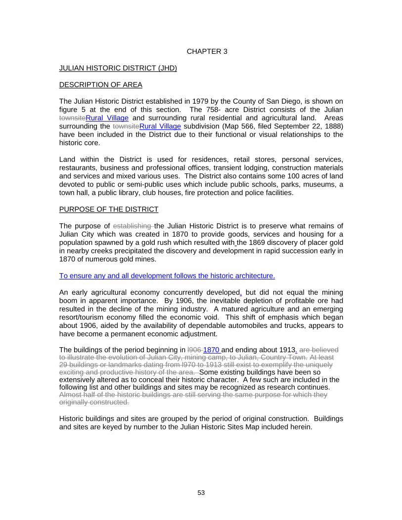
53
CHAPTER 3 JULIAN HISTORIC DISTRICT (JHD) DESCRIPTION OF AREA The Julian Historic District established in 1979 by the County of San Diego, is shown on figure 5 at the end of this section. The 758- acre District consists of the Julian townsiteRural Village and surrounding rural residential and agricultural land. Areas surrounding the townsiteRural Village subdivision (Map 566, filed September 22, 1888) have been included in the District due to their functional or visual relationships to the historic core. Land within the District is used for residences, retail stores, personal services, restaurants, business and professional offices, transient lodging, construction materials and services and mixed various uses. The District also contains some 100 acres of land devoted to public or semi-public uses which include public schools, parks, museums, a town hall, a public library, club houses, fire protection and police facilities. PURPOSE OF THE DISTRICT The purpose of establishing the Julian Historic District is to preserve what remains of Julian City which was created in 1870 to provide goods, services and housing for a population spawned by a gold rush which resulted with the 1869 discovery of placer gold in nearby creeks precipitated the discovery and development in rapid succession early in 1870 of numerous gold mines. To ensure any and all development follows the historic architecture. An early agricultural economy concurrently developed, but did not equal the mining boom in apparent importance. By 1906, the inevitable depletion of profitable ore had resulted in the decline of the mining industry. A matured agriculture and an emerging resort/tourism economy filled the economic void. This shift of emphasis which began about 1906, aided by the availability of dependable automobiles and trucks, appears to have become a permanent economic adjustment. The buildings of the period beginning in l906 1870 and ending about 1913. are believed to illustrate the evolution of Julian City, mining camp, to Julian, Country Town. At least 29 buildings or landmarks dating from l970 to 1913 still exist to exemplify the uniquely exciting and productive history of the area. Some existing buildings have been so extensively altered as to conceal their historic character. A few such are included in the following list and other buildings and sites may be recognized as research continues. Almost half of the historic buildings are still serving the same purpose for which they originally constructed. Historic buildings and sites are grouped by the period of original construction. Buildings and sites are keyed by number to the Julian Historic Sites Map included herein.

54
ORIGINAL USE 1870-1883 (25) George Washington Mine (26) Eagle and High Peak Mines (2) Brewery/blacksmith shop (4) Taylor/Bailey residence (3) Haven of Rest Cemetery (10) Swycaffer saloon/butcher shop (12) Wilcox General Store
1884-1893 (21) Julian Elementary School (1) Santa Ysabel School/Library (24) County Jail (11) DeLuca General Store (8) A. Levi & Co./ J. Marks Mercantile (9) Joseph Marks residence 1894-1903 (6) Jacoby General Store (13) Robinson Hotel (14) A.P. Frary, Jr. residence (moved) (20) Baptist parsonage (23) Cuyamaca Union High School (22) Thomas Strick residence (15) Daley residence/rental (moved) (16) Unidentified residence (moved) (18) F.L. Blanc residence (17) F.L. Blanc rental residence (19) F.L. Blanc rental residence (27) Clarence King residence (28) Unidentified residence (2nd Street) (29) F.L. Blanc warehouse 1904-1913 (5) J.C. Silvers store/service station (moved) (7) Town Hall Many more or less significant buildings dating from 1914 to 1937 are still in use and any of them and any of those listed above may be eligible for inclusion in the National Resister of Historic Places. Most existing buildings, 1870-1937, significantly contribute to the image of an historic district. At the establishment of the JHD, an informal understanding with then existing property owners was that the use of a direct property tax assessed for the express purpose of funding the District would never be exacted. POLICIES AND RECOMMENDATIONS 1. Protect and enhance the historic character of designated buildings and

55
landmarks fifty years old or older located within the district boundaries. (ARB) 2. Seek County of San Diego, Coordinate with the appropriate State of California
and U.S. Governmentand federal agencies to seek recognition of the Julian Historic District, the objective being to include the JHD or any of its individual features in registers of historic buildings, landmarks, sites or districts. (ARB, DPLU)
3. Coordinate JHD planning and detailed design objectives with the County of San
Diego Historic Sites Board. (ARB) 4. Mark designated historic buildings, landmarks and sites with identifying devices.
(ARB, DPLU) 5 Erect JHD identifying signs at four points of major road entry into the District,
namely at State Highways 78-79 near Pine Hills Road, at Farmer Road near northwest corner of "Lane Park", at State Highway 79 one mile south of State Highway 78-79 intersection east of townsite and at State Highway 78 near Banner grade summit. [ARB]
56. Encourage CALTRANS, County of San Diego Department of Public Works and
Department of Planning and Land Use to follow JHD planning and detailed design objectives. (DPW, PP)
7. Develop a County procedure which will require Julian Historic District Architectural
Review Board (JHDARB) review of all projects proposed to be constructed within the district whether or not site plan review is required or has been waived by DPLU with or without a JHDARB recommendation to waive site plan review. [R]
86. Enhance the historic character of the District by developing and applying
architectural design standards to future development. Said standards and definitive design guidelines shall apply to new construction, alterations of existing structures, and for design details of site features such as flat work, retaining walls, fences, exterior lighting and landscaping. Guideline criteria shall be developed from appropriate examples known to have existed within the District during its 1870-1914 historic period. (ARB, DPLU)
97. Encourage the recommendation of the Julian Historic District to be listed on the
National Register. (AP, PP) 10. Develop a County procedure which will ensure that a project is field inspected for
compliance with JHDARB recommendations as shown on the County inspector's copy of the approved plans. [DPLU]
118. Enhance the historic character of the district by developing and applying
architectural design standards for any new construction alterations of existing structures and details of features such as paving, retaining walls, fences, lighting and landscaping, which standards shall be developed from examples known to have existed within the district during its 1870-1914 period. (ARB, PP)

56

57
Appendix: Maps
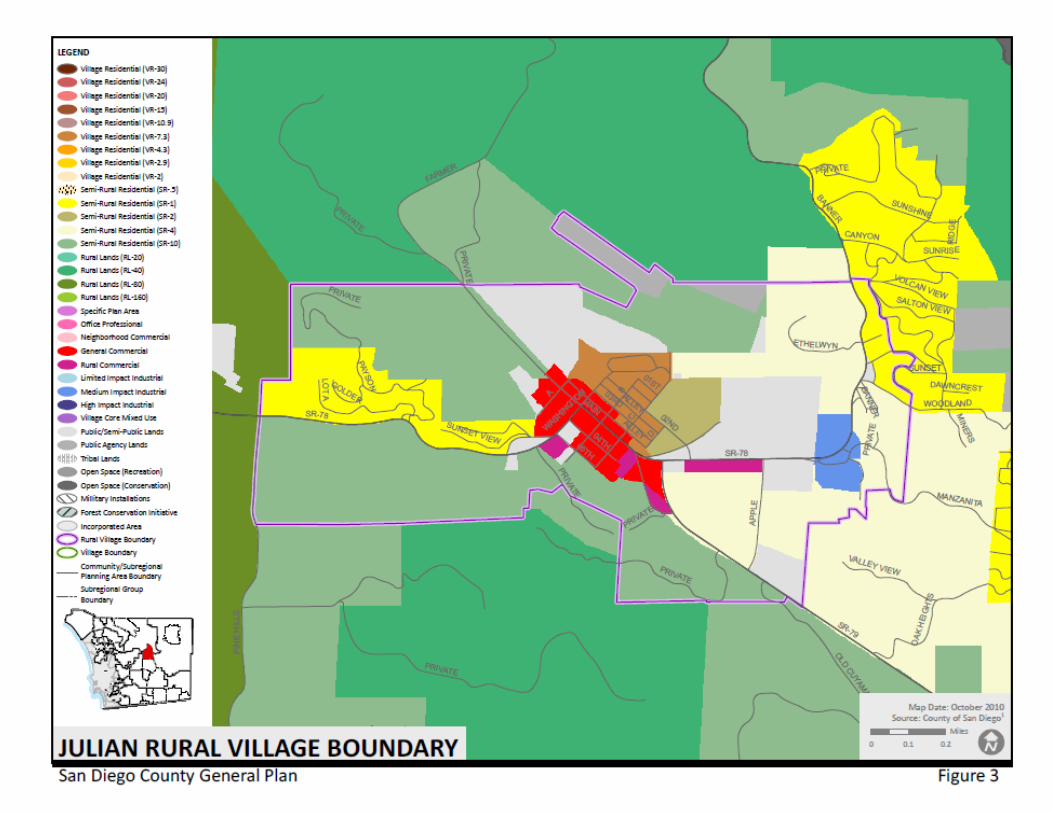
58
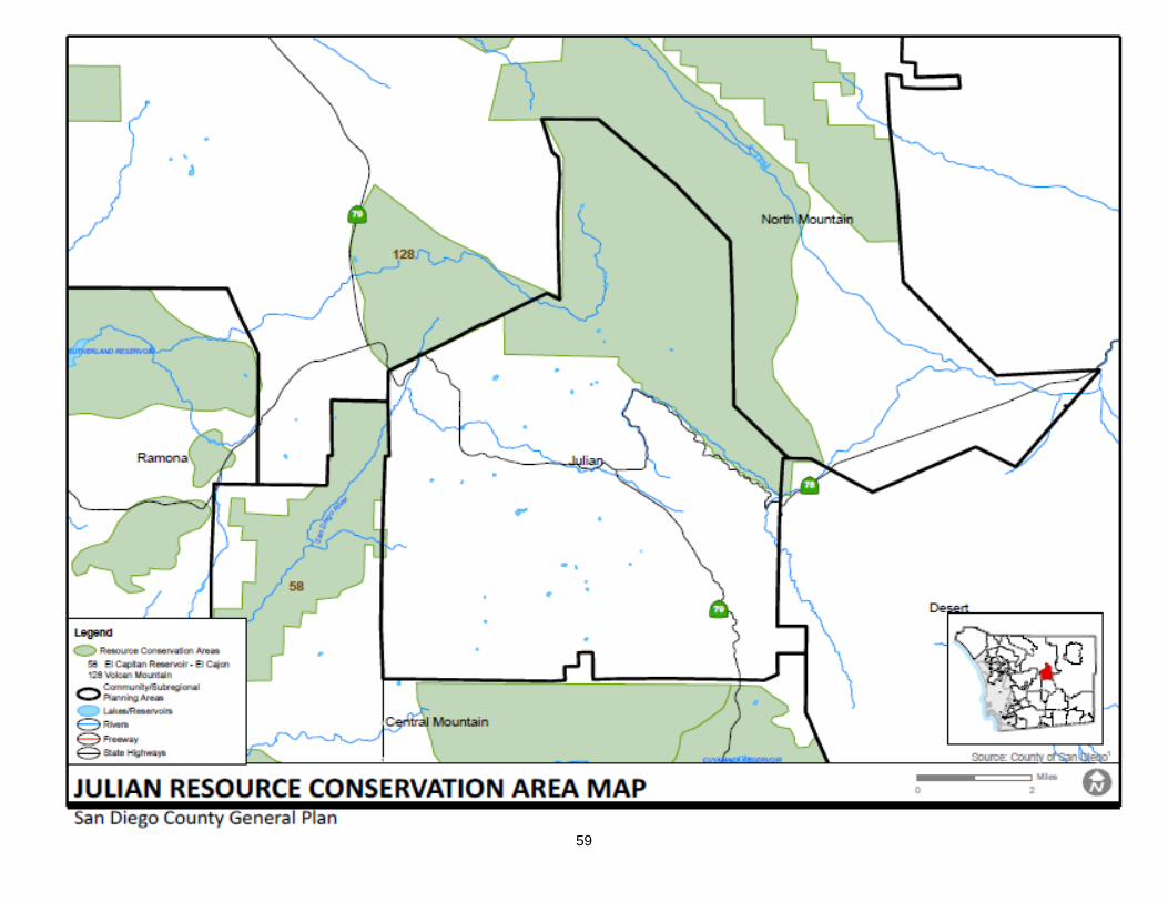
59
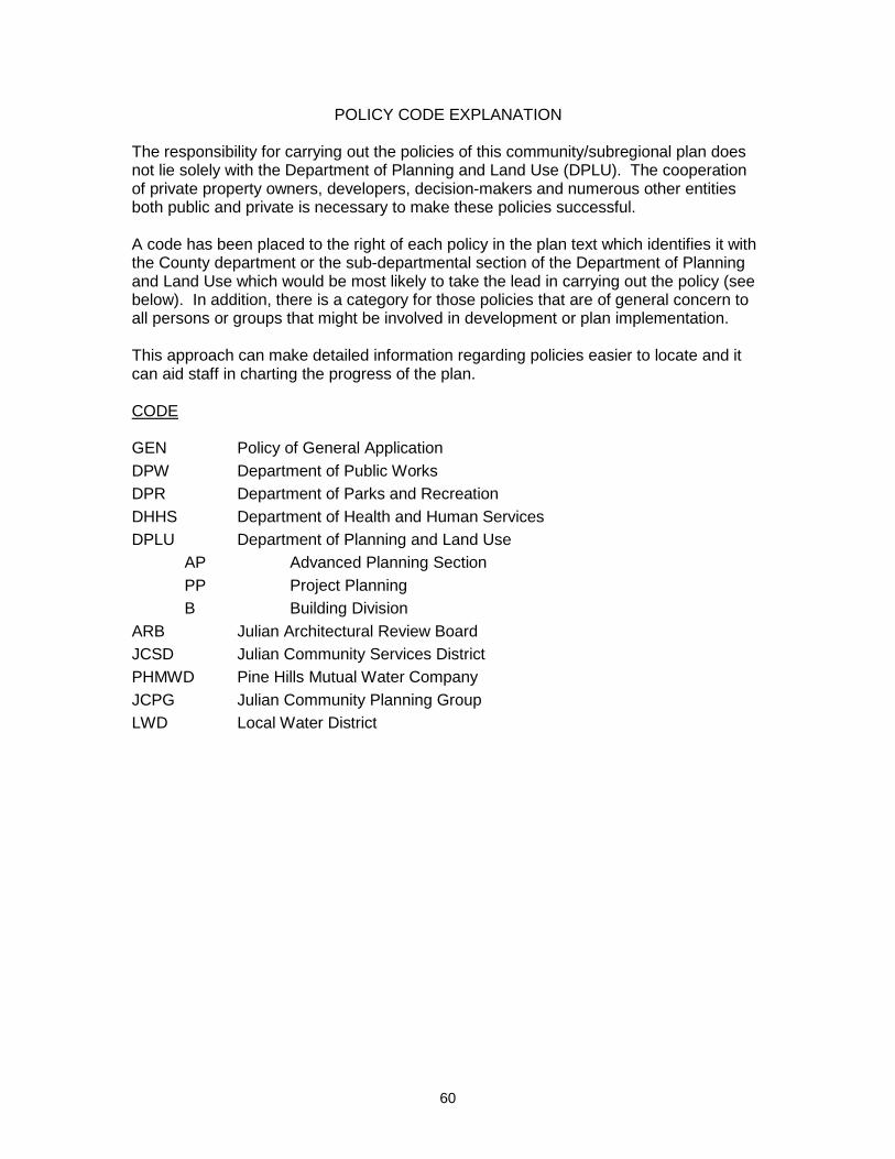
60
POLICY CODE EXPLANATION The responsibility for carrying out the policies of this community/subregional plan does not lie solely with the Department of Planning and Land Use (DPLU). The cooperation of private property owners, developers, decision-makers and numerous other entities both public and private is necessary to make these policies successful. A code has been placed to the right of each policy in the plan text which identifies it with the County department or the sub-departmental section of the Department of Planning and Land Use which would be most likely to take the lead in carrying out the policy (see below). In addition, there is a category for those policies that are of general concern to all persons or groups that might be involved in development or plan implementation. This approach can make detailed information regarding policies easier to locate and it can aid staff in charting the progress of the plan. CODE GEN Policy of General Application DPW Department of Public Works DPR Department of Parks and Recreation DHHS Department of Health and Human Services DPLU Department of Planning and Land Use
AP Advanced Planning Section PP Project Planning B Building Division
ARB Julian Architectural Review Board JCSD Julian Community Services District PHMWD Pine Hills Mutual Water Company JCPG Julian Community Planning Group LWD Local Water District