Up Nately Conservation Area Appraisal - Basingstoke Nately... · structures or features have not...
13
Conservation Area Appraisal Up Nately Conservation Area Appraisal …making a difference Up Nately
Transcript of Up Nately Conservation Area Appraisal - Basingstoke Nately... · structures or features have not...
Conservation Area Appraisal
Up Nately
Conservation Area Appraisal
…making a difference
Up Nately

IntroductionThe Up Nately Conservation Area was designated in 1981 by Basingstoke and Deane Borough Council in recognition of the special architectural and historic interest of the village.
Having designated the Conservation Area, the Local Authority has a statutory duty to ensure that those elements that form its particular character or appearance should be preserved or enhanced, especially when considering planning applications.
It is therefore necessary to define and analyse those qualities or elements that contribute to, or detract from, the special interest of the area and to assess how they combine to justify its designation as a Conservation Area. Such factors can include:
• its historic development;
• the contribution of individual or groups of buildings to the streetscene and the spaces that surround them; and
• the relationship of the built environment with the landscape.
They can also include the less tangible senses and experiences such as noise or smells, which can play a key part in forming the distinctive character of an area.
The Appraisal takes the form of written text and an Appraisal plan. In both respects every effort has been made to include or analyse those elements key to the special character of the area. Where buildings, structures or features have not been specifically highlighted it does not necessarily follow that they are of no visual or historic value to the Conservation Area. The document is intended to be an overall framework and guide within which decisions can be made on a site-specific basis.
This Appraisal of the Up Nately Conservation Area follows its review in 2003 by Basingstoke and Deane Borough Council and explains what its designation means for those who live and work in the area.
This document was adopted as Supplementary Planning Guidance by the Borough of Basingstoke and Deane on 17 July 2003 and complements the policies of the Borough Local Plan (review).
It has been subject to consultation with Councillors, the Parish Council and local amenity groups. A full list of consultees, copies of their responses, and details of the Council’s consideration of the issues raised during the consultation period are available for inspection, by appointment, at the Civic Offices, during normal office hours.
Conservation Area Appraisal
Up Nately2
North Doorway of St Stephen’s Church

Location and PopulationUp Nately is situated approximately four miles east of Basingstoke. The village lies on the northern edge of the chalk downland, on a gentle, north-facing slope. The old Basingstoke Canal runs through the northern half of the village. The Conservation Area includes all but the Heather Lane area of the village that lies to its north. The boundary is drawn tightly around the plots either side of the lane, from the main Greywell Road, and along the road itself.
The population of the Conservation Area in 1998 was approximately 45 (projection based on the Hampshire County Council Planning Department Small Area Population Forecasts 1995).
Historic DevelopmentSettlement Origins
The village of Up Nately was included in the Great Manor of Mapledurwell until early in the 12th century. Then Adam de Port, Lord of Mapledurwell, granted most of the settlement and land of Up Nately to the Cistercian Abbey of Tyron in France. This grant was confirmed by Henry I and the estate, subsequently known as the Manor of Andwell, was colonised by a number of monks.
In the reign of Edward III, however, all alien priories in England, including Andwell, were sequestered by the monarch, whose allegiance was to France. In 1391, the Manor of Andwell was bought by William of Wykeham, Bishop of Winchester. It was bestowed on the newly founded College of Winchester, in whose possession it still remains. Part of Up Nately, however, continued to be included in the Manor of Mapledurwell, after the foundation of Andwell Priory. These lands were transferred to the ownership of Corpus Christi College in Oxford in 1535, along with the rest of the Manor of Mapledurwell.
Settlement Development
Historically, agriculture has played an important part in the establishment and development of Up Nately as a settlement. There is evidence of at least three farms within the Conservation Area. The small size of the farms contrasts with the trend towards larger farms, and the associated extensive enclosure, found elsewhere in Hampshire.
It is possible that this is a result of the particular ownership history of the village by Corpus Christi College. The pattern of roads, buildings, woodland, open fields and commons on College property changed little between 1616 and 1795. In the 18th century, the arrival of the Basingstoke Canal brought many jobs to local people together with the 19th century expansion of a nearby brickworks. The Hampshire Brick and Tile Company was originally run on a very small scale to serve the surrounding area, but it expanded to an area of 32 acres. Later 20th century development has taken place on the northern side of the Greywell Road, in Heather Lane.
Conservation Area Appraisal
Up Nately 3
Gibbs Cottage
View west along Greywell Road

An Appraisal of the Conservation AreaAn Overview
The Appraisal plan identifies those buildings, views and key features that are considered essential to the special character or appearance of the Conservation Area. In addition to listed buildings, it also includes unlisted buildings of particular individual or group value, which are indicated on the Appraisal plan as notable. This is not to undermine the value of other unmarked buildings or structures that reflect the historic development of the village, without detracting from its special qualities.
Individual hedgerows have not been included on the Appraisal plan. However, their contribution to the character of the Conservation Area should not be underestimated and their significance is implicit in the Appraisal.
The appearance of the village is principally one of a varied, linear group of historic buildings in a semi-rural environment. The relationship of the buildings and the spaces between them is a loose one, but is given some visual cohesion by the alignment of the road. The immediate character is essentially residential, yet views of the surrounding landscape are dominant and create a strong, rural quality. This is reinforced by mature vegetation and the hedges that line the lanes. The hillside location of the village is a distinctive feature that enables important views through, into and out of the settlement.
Built Form
There are 12 buildings located in the Conservation Area that are included on the Statutory List of Buildings of Special Architectural or Historic Interest. All are listed as being of local, or regional, special interest (Grade II), apart from St Stephen’s Church, which is of national importance (Grade II*).
These buildings, dating mainly from the 17th century, are of intrinsic architectural and historic interest. Many are located at key visual points in the village. They make a significant contribution to the special character and appearance of the Conservation Area. Some of the older buildings have been altered over successive periods to accommodate changes in their use or contemporary architectural fashions. The re-fronting in brick of existing timber-framed buildings was particularly common in the 18th century. The insertion of carefully arranged sash windows to produce a polite elevation was also popular. Other buildings have retained more completely their vernacular form and materials, for example, Kolkinnon.
There are also several unlisted buildings in the Conservation Area that contribute positively to its special character. These date mainly from the 19th and early 20th centuries and are scattered among the listed buildings, representing an expansion of the village. They are predominantly constructed of vernacular materials and strongly reinforce
Conservation Area Appraisal
Up Nately4
St Stephen’s Church
Blaegrove House and Outbuildings

Conservation Area Appraisal
Up Nately 5
Brick and flint cart shed, Blaegrove House
the special historic character of the village. Some possess features of particular interest. However, in general it is their group value, in association with adjacent listed buildings, that significantly contributes to the overall special interest of the Conservation Area. Historic buildings of particular individual or group value are indicated as notable on the Appraisal plan. This does not undermine the value of other unmarked buildings or structures, which reflect the historic development of the village without detracting from its special qualities.
Key Individual Buildings and Significant Groups of BuildingsSt Stephen’s Church (Grade II*) is thought to date from circa 1200 with 15th and 19th centuries alterations. The north doorway is 13th century with a semi-circular arch and a dog-tooth moulding. In 1844, the exterior of the church was refaced, with bands of red brick and flintwork, with buttresses at the corners. The chancel, tower and vestry were also built at this time. The church, set in a small but important churchyard, dominates the view up the hill, from the west along Greywell Road. It is, therefore, a distinctive and memorable feature of the village. However, from the east, the church only appears from around the bend in the road and from behind Plume House.
Many of the listed buildings reflect the farming traditions of Up Nately. Blaegrove House, Upper House Farmhouse and Kolkinnon (all Grade II) date from the 17th and 18th centuries. Blaegrove House - formerly Bleakgrove Farmhouse - is a substantial red brick building with a symmetrical façade. The rear south wing is earlier, whilst the northern rear elevation dates from the 19th century. Although the main house is screened by mature hedges and trees, the steeply pitched, red clay, tile roof is particularly dominant in views south-east along the lane.
Associated with the farmhouse is a group of outbuildings, including a mid-19th century stable block, cart shed and granary (all Grade II). This group is located on a sharp bend in the lane. It terminates the long view up the lane leading the eye around the bend and further up the hill. The group is evocative of the rural traditions of the village and, therefore, makes an important contribution to the architectural and historic interest of the Conservation Area.
Upper House Farmhouse dates from the 17th and 19th centuries, and is of red brick with a clay tile roof. The building is concealed from the lane behind mature trees. It is given context by a group of farm-related buildings, most notably The Granary (Grade II). Kolkinnon is similarly hidden behind mature vegetation, in a large plot, and is a two-storey timber-framed house with later alterations.

Blaegrove Cottage and Jackdaw Cottage (both Grade II) lie close together, towards the southern end of the lane. Blaegrove Cottage dates from the 16th century, with 17th century additions. It is a two-storey timber-frame construction with painted brick infill, and a hipped thatched roof which reinforces the longitudinal form of the building. The cottage is also an important feature in the Conservation Area, as the eastern end of its northern elevation dominates the view south along the lane. Similarly, its entire southern elevation is visible from the south looking north. The prominence of this building results in it being particularly important in defining the special character of the area. Jackdaw Cottage dates from the 17th century and is two-storeys with red brick infilled timber-frame and a hipped thatch roof. It is set back slightly from the lane and is only visible from immediately in front.
Other buildings of note include Crossways, an early 20th century red brick building with a clay tile roof. It is set back from the crossroad at the northern end of the village, but can be glimpsed from Greywell Road to the west. The brick outbuilding behind backs onto the main lane, and helps create a pinch point with the mature trees opposite. The distinctive diaper brick of Gibbs Cottage adds to the mix of architectural features present along the lane. The single-storey, flint-faced Old School House adjoins the church on the Greywell Road. Although much altered, it reflects the style of the church and is, therefore, a complimentary feature in its setting.
Further along Greywell Road, at the eastern entrance to the Conservation Area, lies Plume House. The building was once the The Plume of Feathers public house, an important building in this small community, but is now a large private house. The white-painted front elevation is gradually revealed from around the bend in the road.
Although a modern group of buildings, the barn structures at the Lyde House Riding School are prominent at the western entrance to the Conservation Area. They are resonant of the traditional farm buildings that characterise the area.
Conservation Area Appraisal
Up Nately6
Blaegrove Cottages
Plume House

The Character and Importance of Public and Private SpacesKolkinnon Farmhouse is set within a large square plot, which may be one of the first sites developed in the village. Although this is not a particularly open space, the building remains within the correct context. In general, however, the value of the open spaces in the Conservation Area is to enable views out of the area, to the countryside setting. This reinforces its strong rural character and appearance.
To the south of the church is an open field of gently rising land. This provides extensive views out of the Conservation Area to the south and east, and northwards to Plume House and the church.
To the west of the lane lies open land. This also allows views out of the Conservation Area over landscape to the west, and towards Crossways and the Lyde House Riding School. To the east, the large open space behind Blaegrove House enables views to this important group of buildings, including The Granary and the open countryside beyond.
The lane itself is an important space defined, and enclosed, by the mature vegetation along its edges. It is punctuated by key buildings at various points. The bend in the lane at Blaegrove House is a special feature that creates interest in the view and brings the long and tall flint boundary walls to prominence.
The character of the tree cover in the Conservation Area is broad-leaved, with ash and oak the predominant species. Occasional species of conifer include Scots pine and yew, the latter forming a notable enclave to Blaegrove House.
Building MaterialsThe prevalent traditional building materials are timber-frame, with brick infill, mellow red brick or red brick with flint banding. Thatch and red clay tile are used as roofing materials.
Given the domestic scale and simple vernacular architecture of the buildings in the Conservation Area, historic joinery (such as timber casement windows, doors and door hoods) are often the features that define the appearance of properties. Where buildings are close-knit in continuous street frontages the relationship of these features and their historic arrangement becomes a significant factor in the overall special character of the area. Although some groups of buildings have been modernised, the use and overall effect of inappropriate replacement windows and doors is limited.
Conservation Area Appraisal
Up Nately 7
View towards Lyde House Riding School
View towards Brick Kiln Bridge and Basingstoke Canal

The Setting of the Conservation AreaThe Conservation Area is set within an undulating chalk landscape on a slight north-facing slope. The landscape around the village is agricultural and predominantly arable, but with sheep farming still in evidence. To the north of the village runs the course of the old Basingstoke Canal, which remains an important feature within the landscape. Much of the older part of the village is hidden from the traveller on the main road. It is only on exploring the narrow, meandering, enclosed lanes running to the south and north-east that many of the historic buildings are revealed.
Areas of Archaeological SignificanceEvery settlement contains within it archaeological evidence of its origins and development, for the economy and industry of the community and the lives and lifestyles of past inhabitants.
It is in the Areas of High Archaeological Potential (AHAP) that it is most likely that such archaeological remains will be encountered.
Where a development is proposed, the impact that it might have on these remains is a material consideration within the planning process. This may occasionally result in the need for archaeological recording in the case of some developments.
There are two AHAPs in the Conservation Area. The first, and smaller, can be found around Upper House Farm, located at the southern end of the lane. This farm appears to be a focus for several cottages dating from the 16th and 17th centuries.
The second AHAP is located around Kolkinnon house. This includes the church and plots to the south-east of it. The large square unit includes the former farmhouse. This may have been one of the primary units of this settlement, along with the farm to the south and plots to the north and east.
There is one Area of Archaeological Potential (AAP) that includes the areas along the road, linking the two foci of this settlement. It is possible that the isolation of the two farms occurred due to shrinkage of the village.
Conservation Area Appraisal
Up Nately8
Outbuilding at Upper House Farmhouse

Conservation Area Appraisal
Up Nately 9
Old School House
Conservation Area Planning ControlsThe following controls apply within the Conservation Area in addition to normal planning controls:
• Conservation Area Consent is normally required for the demolition of buildings or structures over a certain size within a Conservation Area.
• The Council must be given six weeks notice of any intention to undertake works to, cut down or uproot any trees over a certain size in the Conservation Area.
• Planning applications which, in the opinion of the Borough Council, would affect the special character of the Conservation Area must be advertised and the opportunity given for public comment. This may include proposals outside the Conservation Area which nevertheless affect it setting.
Statutory policies relating to Conservation Areas and listed buildings are set out in the adopted Basingstoke and Deane Borough Local Plan. These policies reflect the statutory duty on the Local Planning Authority to have regard to the preservation of historic buildings or their setting, and to the enhancement of areas designated as being of special interest. These policies seek to ensure that particular attention will be paid to the scale, height, form, materials and detailing of proposals including boundary treatments and other features of note. In order to consider the implications of development and given the detail required, the Borough Council will normally require proposals within the Conservation Area to be submitted in the form of a full, and not outline, application. The Borough Council’s conservation officers are available for advice and information on all matters relating to development proposals in the Conservation Area.
GrantsThe Borough Council provides grants for various types of work. These include Historic Buildings Grants, Environment and Regeneration Grants, and Village and Community Hall Grants. Leaflets are available explaining the purpose and criteria for each grant and an approach to the Council is recommended for further information on any grant.
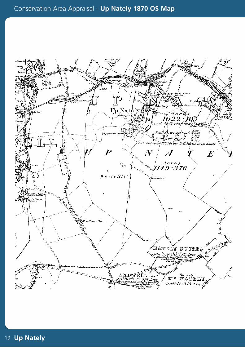
Conservation Area Appraisal - Up Nately 1870 OS Map
Up Nately10

IntroductionLorem ipsum dolor sit amet, consectetuer adipiscing elit, sed diam nonummy nibh
euismod tincidunt ut laoreet dolore magna aliquam erat volutpat. Ut wisi enim
ad minim veniam, quis nostrud exerci tation ullamcorper suscipit lobortis nisl ut
aliquip ex ea commodo consequat. Duis autem vel eum iriure dolor in hendrerit
in vulputate velit esse molestie consequat, vel illum dolore eu feugiat nulla facilisis
at vero eros et accumsan et iusto odio dignissim qui blandit praesent luptatum
zzril delenit augue duis dolore te feugait nulla facilisi neque porro quisquam est,
qui dolorem ipsum, quia dolor sit, amet, consectetur, adipisci velit, sed quia non
numquam eius modi tempora incidunt, ut labore et dolore magnam aliquam
quaerat voluptatem.
Lorem ipsum dolor sit amet, consectetuer adipiscing elit, sed diam nonummy nibh
euismod tincidunt ut laoreet dolore magna aliquam erat volutpat. Ut wisi enim
ad minim veniam, quis nostrud exerci tation ullamcorper suscipit lobortis nisl ut
aliquip ex ea commodo consequat. Duis autem vel eum iriure dolor in hendrerit in
vulputate velit esse molestie consequat, vel illum dolore eu feugiat nulla facilisis at
vero eros et accumsan et iusto odio dignissim qui blandit praesent luptatum zzril
delenit augue duis dolore te feugait nulla facilisi.
Pleff lorem monaq morel plaff lerom baple merol pliff ipsum ponaq mipsu ploff
pimsu caple supim pluff sumip qonaq issum daple ussum ronaq ossom fap25
abcde tonaq fghij gaple klmno vonaq pqrst haple uvwxy nonaq zzzz. Laple pleff
lorem monaq morel plaff sumip qonaq issum daple ussum ponaq gaple klm50
lore.
Conservation Area Appraisal - Up Nately Tithe Map
Up Nately 11
Picture Text
Picture Text
Picture Text
Picture Text

Conservation Area Appraisal - Up Nately Areas of Archaeological Potential Map
Up Nately12
y
eal
Courtesy of Hampshire County Council

Conservation Area Appraisal
Up Nately
…making a difference
Basingstoke and Deane Borough Council
Civic Offices London Road Basingstoke Hants RG21 4AH Telephone 01256 844844 Fax 01256 845200www.basingstoke.gov.ukProduced by Graphics/Corporate Information Division April 2004
5216