Unusual Diamond-bearing Rocks of the Wawa...
31
- - - . : £- a — . L Unusual Diamond-bearing Rocks of the Wawa Area Unusual Diamond Unusual Diamond- bearing Rocks of bearing Rocks of the Wawa Area the Wawa Area Institute on Lake Superior Geology 52 nd Annual Meeting Sault Ste Marie, Ontario Volume 52 Part 3 – Field Trip Guidebook PDF compression, OCR, web-optimization with CVISION's PdfCompressor
Transcript of Unusual Diamond-bearing Rocks of the Wawa...
-
-
-
.
:
£- a
—
.
L
Unusual Diamond-bearing Rocks of the Wawa Area
Unusual DiamondUnusual Diamond--bearing Rocks of bearing Rocks of the Wawa Areathe Wawa Area
Institute on Lake Superior Geology
52nd Annual Meeting Sault Ste Marie, Ontario
Volume 52 Part 3 – Field Trip GuidebookPDF compression, OCR, web-optimization with CVISION's PdfCompressor

Unusual Archean Diamond-bearing rocks of the Wawa Area
by
A. C. Wilson
Ministry of Northern Development and Mines, Resident Geologist’s Program,
Ontario Geological Survey, Timmins, Ontario
On the cover (clockwise from top): Giant lower crustal to upper mantle xenoliths, Enigma Property, Menzies Township, Oasis Diamond Corporation Inc.; Diamonds from the Festival Property (photo courtesy
of Pele Mountain Resources Inc.); Sandor Diamond Occurrence, Highway 17, Spider Resources Inc. & KWG Resources Inc.; Heterolithic diamond-bearing breccia, Engagement Zone, Northern Sierra Minerals
Corporation
PDF compression, OCR, web-optimization with CVISION's PdfCompressor

Table of Contents
Introduction .................................................................................................................................................... 3 Geological Overview of the Michipicoten Greenstone Belt........................................................................... 3 Quaternary Geology ....................................................................................................................................... 6 Structural Geology of the Diamond-bearing Rocks ....................................................................................... 6 Description of the Diamond-bearing Rocks ................................................................................................... 7 Relationship between diamond content and lithology.................................................................................. 10 Geochronology ............................................................................................................................................. 11 Geochemistry of the Diamond-bearing Rocks ............................................................................................. 11 Diamond characteristics ............................................................................................................................... 11 Origin of the Diamond Deposits................................................................................................................... 12 Field Trip Road Log ..................................................................................................................................... 14
STOP 1 - GQ Diamond Discovery Site ................................................................................................... 14 STOP 2 - Northern Sierra Minerals Corporation Area B......................................................................... 17 STOP 3 - Northern Sierra Minerals Corporation Engagement Zone ....................................................... 21 STOP 4: - Moet Occurrence, Festival Property ....................................................................................... 23 STOP 5: - Sandor Diamond Occurrence.................................................................................................. 25 STOP 6: - Dubreuilville Dike - Xenolith-rich lamprophyre .................................................................... 27 STOP 7: - Monchiquite Dike ................................................................................................................... 28 STOP 8: - Contemplation of the rocks on the fireplace at the Wawa Motor Hotel ................................. 28
Bibliography................................................................................................................................................. 29
Figures 1. Generalized geological map of the Michpicoten greenstone belt ............................................................. 4 2. Composite structural section through the central part of the Michipicoten greenstone belt. .................... 7 3. Detailed geology of the southwestern corner of the Festival Property ..................................................... 8 4. Geological compilation of the GQ Property ........................................................................................... 15 5. Occurrences of diamondiferous bedrock on the GQ Property................................................................ 16 6. Drill hole sections GQ-00-01, GQ-00-02 and GQ-00-03, GQ Property.................................................. 18 7. Northern Sierra Minerals Corporation Area B ........................................................................................ 20 8. Geology and sample locations at the Engagement Zone ......................................................................... 22 9. Simplified cross section through the Engagement Zone looking northwest........................................... 23 10. Detailed geology of the Moet Occurrence.............................................................................................. 24 10. Detailed geology of the Sandor Occurrence ........................................................................................... 26 11. Generalized geology of the Wawa Project ............................................................................................. 26 12. Lower crustal to upper mantle xenolith, Dubreuilville dike ................................................................... 27 Tables 1. Diamond recovery results from 2000 Band-Ore Resources Ltd. diamond-drilling program ................. 17 2. Diamond results from Engagement Zone bulk samples (2001).............................................................. 21 3. Summary of the diamond results from the 2001-02 sampling of the Moet Occurrence......................... 25
2
PDF compression, OCR, web-optimization with CVISION's PdfCompressor

Unusual Diamond-bearing rocks of the Wawa Area
Introduction In 1991, local prospector C. “Mickey” Clement recovered at least three alluvial diamonds from the Michipicoten River. Two of the stones were sent to the Department of Mineralogy, Royal Ontario Museum, where they were identified as industrial-grade diamonds with weights of 1.05 and 1.13 carats. Both stones were described as frosted and graphite-inclusion riddled. In 1995, prospector Sandor Surmacz and geologist Marcelle Hauseux recovered diamonds from a bedrock occurrence on the Trans Canada Highway, approximately 20 km north of the town of Wawa. An 18.1-kg bulk sample of a xenolith-rich lamprophyre yielded 1 macrodiamond and 5 microdiamonds. All but one was gem quality. Since then, more than 50 occurrences of diamondiferous bedrock have been reported in an area of approximately 30 km2 in size, centred approximately 20 km north of the town of Wawa. The occurrences are hosted within a sequence of unusual, Archean-aged, heterolithic breccias. Historically, this sequence of rocks has received little exploration interest and was considered to have little economic significance. This field trip will focus on exposures of a series of foliated lamprophyre dikes and associated heterolithic breccias outcropping in Lalibert, Leclaire, Menzies and Musquash townships. This field trip guide represents a summary of information available at the time of writing and should not be considered the final analysis of these rock types. Much more research is required on these rocks. Active exploration and research is still underway on the properties included in this field guide. Given the limitations of time, the field trip will visit only some of the more accessible properties. Bear in mind that when visiting active exploration or mine properties, permission must be granted by the property owner. Current ownership information can be obtained from the Resident Geologist’s Office in Timmins, or the District Geologist’s Office in Sault Ste Marie, Ontario. Geological Overview of the Michipicoten Greenstone Belt The Wawa region lies within the Wawa subprovince of the Canadian Shield. The Michipicoten greenstone belt extends inland for approximately 150 km from the Lake Superior shore and has an average width of 38 km. The greenstone belt consists of supracrustal rocks of Archean age. Younger Archean granitic rocks surround the greenstone belt. Figure 1 shows a generalized geological map of the Michipicoten greenstone belt. The oldest volcanic cycle is approximately 2900 Ma and is of limited distribution. This cycle is best developed in Esquega Township along the southern flank of the supracrustal assemblage. Portions of this metavolcanic cycle extend into eastern McMurray and western Lastheels townships. The base of this volcanic cycle consists of massive to pillowed komatiitic flows intruded by mafic sills. The ultramafic rocks are overlain by intermediate to felsic tuffs capped by thinly bedded chert-magnetite-sulphide iron formation (Judith-Kathleen Iron Formation). Intermediate to felsic metavolcanic tuffs below the Judith iron formation have been dated at 2889 ± 9 Ma (Turek et al. 1992). Overlying the 2900 Ma cycle is a 2750 Ma volcanic cycle. This volcanic cycle is predominately composed of intermediate to felsic tuffs, breccias and flows. Porphyritic and spherulitic flows are not common and most of the intermediate to felsic metavolcanic rock is fragmental. The base of this cycle consists of high magnesium and high iron tholeiitic massive and pillowed flows. It lies conformably atop the Judith-Kathleen iron formation at the east end of Wawa Lake, but the basal unit is poorly exposed elsewhere. Overlying the mafic metavolcanic rocks is a sequence of heterolithic, intermediate to mafic breccia that has been traced for a distance of over 13 kilometers. This unit is in turn, overlain by a thick section of intermediate to felsic tuffs, breccias and massive flows that reaches a maximum thickness of approximately 2000 m below the Helen Iron Formation. The upper part of the intermediate to felsic metavolcanic rocks has been dated at 2749 ± 2 Ma (Turek et al. 1992). The Michipicoten (Helen) iron formation caps this
3
PDF compression, OCR, web-optimization with CVISION's PdfCompressor
usiv
e R
ocks
S
Intr
usio
ns
fic In
trus
ive
Roc
ksR
ocks
men
tary
Roc
ksni
c R
ocks
riic
Roc
ks
ence
s in
ithic
Bre
ccia
an
\
II C
arbo
natit
e In
trA
lkal
ic In
trus
ion
San
ukito
id S
uite
II G
rani
toid
sM
afic
toI
I Che
mic
alC
last
ic M
etas
edi
II
Fel
sic
Met
avol
caM
afic
Met
avol
cai
.F
aults
Dia
mon
d O
ccur
rA
rche
an H
eter
ol
\\\\Creek Fault
rtie
s D
iscu
ssed
in
erty
/rr
ence
Lalib
ert L
ecre
nce
1J
Zon
ece ro
pert
y
icke
nson
Lak
eS
tock
Lake
Sup
erio
i
— —
Dia
mon
d P
ro p
e1
1 E
nigm
a P
rop
2 S
ando
r O
ccu
3 C
rista
l Occ
ur4
Eng
agem
ent
5 G
Q O
ccur
ren
6 Le
adbe
tter
P
N
10 I
—
Figu
re 1
. G
ener
aliz
ed g
eolo
gica
l map
of t
he M
ichi
pico
ten
gree
nsto
ne b
elt s
how
ing
som
e of
the
diam
ond
occu
rren
ces (
mod
ified
afte
r Sto
tt et
al.
2002
).
PDF compression, OCR, web-optimization with CVISION's PdfCompressor
this volcanic cycle. It commonly exceeds 100 m in thickness and, in the vicinity of the past-producing Helen Mine; it has been tectonically thickened to over 300 m. This iron formation was the source of virtually all commercial iron ore production in the Wawa area from 1898 to 1998. The youngest metavolcanic rocks in the area are those of the 2700 Ma volcanic cycle. These rocks underlie approximately fifty-percent of the Michipicoten greenstone belt and are found in the central and northern parts of the belt. The basal unit is composed of massive and pillowed mafic amygdaloidal flows that attain a maximum thickness of 5.5 km in the Goudreau area. This unit is overlain by intermediate to felsic metavolcanic rocks, or their stratigraphic equivalent, the Doré metasedimentary rocks. These metavolcanic rocks are typically composed of tuffs and monolithic and heterolithic breccias. Quartz + feldspar crystal tuff and an intermediate tuff from this volcanic cycle returned a U-Pb zircon age of 2701 ± 8 Ma (Turek et al. 1992) and 2701.4 ± 2.1 Ma (Ayer et al. 2003). The intermediate to felsic tuffs interdigitate with clastic metasedimentary sequences that include cross-bedded sandstone and a tonalite cobble conglomerate (Doré conglomerate). Corfu and Sage (1987, 1992) reported an age of 2698 ± 2 Ma for a tonalite clast in the Doré conglomerate and maximum ages of 2680 ± 3 and 2682 ± 3 Ma for sedimentary sequences in northern and central parts of the Michipicoten greenstone belt. Geochronological and structural evidence indicates that sedimentation continued after cycle 3 volcanism and predated a major folding and faulting event. Arias (1996) noted that the rocks comprising cycle 3 in the central part of the Michipicoten greenstone belt are upside down and represent the overturned limb of a belt-scale recumbent nappe fold. This inverted limb has been refolded and imbricated by subsequent south-verging thrust faults, which caused local repetition of the stratigraphic sequence (Wilson 2004). Felsic plutonism occurred synchronous with all of the major volcanic cycles and continued after volcanism ceased at Wawa. Plutonic rocks associated with cycle 1 volcanism include the Murray-Algoma porphyry (2881± 6 Ma) and the Regnery biotite granite of the Hawk Lake granitic complex (2888 ± 2 Ma). Both intrusions are situated in Esquega Township. The Jubilee granitic stock, located in McMurray Township, was dated at 2745 ± 3 Ma and is coeval with cycle 2 volcanism. Plutons associated with cycle 3 volcanism range in composition from tonalite through granodiorite and granite and have ages ranging from 2698 to 2693 Ma. These plutons are located south and west of the Michipicoten greenstone belt (Stone and Semenyna 2004). The Kapuskasing Structural Zone extends east from the shore of Lake Superior, northeast through Kapuskasing and into the Hudson Bay Lowland. Local features interpreted to be associated with it include northeast-striking Proterozoic lamprophyre dikes (Sage 1994; Morris 1999). Lamprophyre dikes of middle Proterozoic age are common in the region south of the Wawa-Hawk-Manitowik Lake Fault and rare to non-existent north of the fault. They are carbonate, biotite, and sometimes olivine-rich and usually less than 1.0 m in width. The dikes generally strike northeast. Dikes exposed in McMurray Township commonly have blue to blue-green sodic amphibole developed in their wall rocks. This mineral has been interpreted to be a product of fenitization. These dikes are likely spatially and temporally related to the emplacement of the Keewenawan-age Firesand River Carbonatite (Sage 1994). North of the Wawa-Hawk-Manitowik Lake Fault, in the area extending west from the former Magpie Mine (Leclaire Township), to the east side of the Dickenson Lake Stock (Lalibert Township), there are a series of what appear to be narrow, biotite-amphibole-rich dikes that have been interpreted as Archean lamprophyres. These dikes commonly have large, rounded inclusions (lower crust to upper mantle-derived xenoliths) up to 3.0 m in size, the centres of which are often completely altered to radiating clusters of actinolite crystals. Titanite from the matrix of one of these dikes returned an age of 2703 ± 42 Ma (Sage 2000). The date is interpreted to be a minimum age of intrusion. Subsequent dating of a zircon from a gneissic xenolith from the same dike returned an age of 2684.9 ± 1.4 Ma (Ketchum, Kamo and Davis 2003).
5
PDF compression, OCR, web-optimization with CVISION's PdfCompressor
Several narrow (<10 m) kimberlite dikes also intrude the Michipicoten greenstone belt. These dikes are largely restricted to the eastern part of the greenstone belt and are spatially related to the northeast-trending Kapuskasing Structural Zone. Several of these dikes have been dated. Intrusions K115 and K121, located in Isaac Township, returned an average 87Rb/86Sr age of 1097 ± 7 Ma (Kaminsky et al. 2002). A kimberlite dike intersected in Pele Mountain Resources Inc.’s drill hole 97-34, drilled in Riggs Township, returned a 207Pb/206Pb age of 1197 ± 24 Ma (R. P. Sage, Ontario Geological Survey, unpublished, 2000; Wilson 2004). Quaternary Geology All Quaternary deposits within the Wawa area were deposited during the Late Wisconsin by the Labrador sector of the Laurentide Ice Sheet. Peat, recovered from a bog located within the surface of a terrace associated with the highest glacial lake in the Lake Superior basin, was radiocarbon dated at 9759 ± 170 BP. A caribou antler, recovered from near the surface of the delta of glacial lake Minong III, yielded a radiocarbon date of 8820 ± 80 BP (Morris 2001). Bedrock striae indicate that there were two prominent ice flow directions. The oldest and most pervasive ice flow was south to southwest (159° - 240°). A later, weaker ice flow was to the southwest and west (220° - 290°). The younger set of striae was formed during the latter stages of glaciation as the ice sheet began to thin and bedrock topography began to influence the direction of ice flow. Much of the overburden consists of a thin (< 1 m), discontinuous till veneer draped over the bedrock. Most of the area's thicker surficial deposits are located within bedrock controlled valleys where glaciolacustrine waters from the Lake Superior basin covered the area. In several of these valleys, the glaciofluvial material reaches thicknesses up to 32 m (Morris 2001). Structural Geology of the Diamond-bearing Rocks The greatest concentration of diamond-bearing rocks in the Michipicoten greenstone belt is constrained to a roughly 30 km2 block of land coinciding with a D1 recumbent nappe identified by Arias (1996). The nappe lies immediately north and adjacent to the Kapuskasing Structural Zone and has affected the two youngest rock sequences in the greenstone belt. In cross section, a generalized structural section across the greenstone belt would be upside down and represents the overturned limb of a belt-scale recumbent fold. This inverted limb of the nappe fold has been refolded and imbricated by subsequent south-verging thrust faults. The result is that the geometry of the rocks hosting the diamondiferous bedrock is that of an inverted anticline (Arias and Helmsteadt 1990). The effect is to create a tectonic repetition of the diamond-bearing sequence of rocks. In simplified terms, the rocks hosting the diamonds in the Wawa area can be considered as a single, overturned fold limb that has been faulted along a series of thrust zones. As a result, the diamond-bearing breccias, the lamprophyres associated with them and the surface onto which these metavolcanic rocks were deposited has been repeated at least four times (Walker 2002). The western limit of the nappe is likely the Dickenson Lake fault that passes along the west side of the Dickenson Lake stock. Extrusive lithologies similar to those hosting diamonds were recognized to the east of the stock by Sage (1993) during reconnaissance mapping. To date, no diamondiferous occurrences have been discovered to the west of the Dickenson lake fault. The eastern limit of the nappe is the Marsden Lake fault. Prior to 2002, rocks favourable to hosting diamonds had not been observed east of this structure (Wilson 2004). However, in 2002, Oasis Diamond Exploration Inc. made a discovery of diamonds on the east shore of the Magpie River and in 2004, diamondiferous occurrences of bedrock were found on the west shore of the Magpie River in Chabanel Township. These discoveries suggest that the potential for these host rocks extends farther eastward than previously believed. Figure 2 shows a graphic representation of the nappe structure.
6
PDF compression, OCR, web-optimization with CVISION's PdfCompressor

500
F
oslon
Figure 2. Composite structural section through the central part of the Michipicoten greenstone belt. Section X-Y from south-central Corbiere Tp. (Josephine Iron Range) to Andre Lake central Corbiere Tp. Section Y-Z is a schematic section from west central Lalibert Tp. The sketch in the lower left explains the present configuration of the belt as a regional nappe fold (F1) refolded about F2. Imbricate thrusts are considered related to Fs (Arias 1996). Description of the Diamond-bearing Rocks The diamond-bearing breccia and associated lamprophyre is broadly distributed throughout Lalibert, Leclaire, Menzies and Musquash townships. On-going mapping by Pele Mountain Resources Inc. on the Festival property and by Nathalie Lefebvre on the GQ Property has helped to refine the classification of these rocks. Systematic exploration and sampling suggest that the individual diamond occurrences are part of a much larger suite of rocks and that diamonds occur primarily within discrete layers at the base of diamond-bearing zones. North-northwest-trending diamond-bearing zones of breccia and lamprophyre are up to 1500 m in length and up to 800 m in width (Pele Mountain Resources Inc., press release, January 18, 2005). The breccia forms thick units (maximum true thickness is approximately 110 m) dipping to the northeast 30°. The lateral extent and thickness of the breccia unit is not well constrained, owing to the large-scale regional folding and thrusting (Lefebvre 2004). Figure 3 provides a detailed map of the southwest corner of the Festival Property showing a recent interpretation of these diamond-bearing zones. The diamond-bearing rocks can be visually subdivided into two classes, lamprophyre (dikes and bodies of indeterminate morphology) and heterolithic or polymict breccias. It is often difficult to differentiate between the two classes since the lamprophyre dikes frequently contain an assortment of inclusions that
7
PDF compression, OCR, web-optimization with CVISION's PdfCompressor

F'
Occ
urre
nces
iyri
c Su
ite
km
Lege
r*
Dia
mon
d I
• S
outh
Zor
• N
orth
Zor
• O
ther
•I
Taf
t
Cri
stal
Eas
tP
erch
it
Sal
on
Sal
on
Lecl
aire
Tp.
Mus
quas
h T
p.
Dom
.Per
lgno
n
Per
thLa
ke
Per
— —
—I_
——
Bol
linge
rI
Ros
igtj
II I
---:
Ger
i
Mum
mI
Men
zies
Tp.
e iot
Gen
esis
Wes
t
Veu
v
Figu
re 3
. D
etai
led
geol
ogy
of th
e so
uthw
este
rn c
orne
r of t
he F
estiv
al P
rope
rty (m
odifi
ed fr
om P
ele
Mou
ntai
n R
esou
rces
, Inc
. pre
ss re
leas
e, Ja
nuar
y 18
, 200
5).
The
units
show
n in
gre
en c
onsi
st o
f maf
ic to
inte
rmed
iate
m
assi
ve a
nd p
illow
ed fl
ows,
brec
cias
and
tuff
s (V
ailla
ncou
rt 20
05b,
Sag
e et
al.
1982
)
8
PDF compression, OCR, web-optimization with CVISION's PdfCompressor

give them the appearance of breccia. The lamprophyre dikes cut the breccia units. Both lithologies have been metamorphosed to upper greenschist facies. The breccia primarily consists of angular, pebble-sized, lithic fragments, mainly of volcanic composition, contained within a green to grey fine-grained matrix. The matrix grain size ranges from < 2 mm to 1 mm. At least eleven distinctive types of lithic fragments have been observed in the breccia and the fragments are irregularly distributed throughout the breccia. The clast population is primarily derived from rocks with which the breccia is intercalated. Most typically these clasts are mafic and felsic metavolcanic rocks and intermediate to mafic intrusive rocks. Other clast types include fragments of clast-supported breccia within matrix supported breccia, fragments of earlier matrix-supported breccia with fewer than 5% fragments and coated lithic fragments (Lefebvre 2004). The breccia is characteristically massive, unstratified and poorly sorted with clast size ranging from sand to boulders up to 9 m. Primary sedimentary structures such as bedding and crude grading are rare (Lefebvre 2004). Petrographic work by Lefebvre (2004) on the breccias identified a typical fragmental texture within a mineralogically variable matrix. Typically the groundmass is dominated by actinolite, but chlorite and biotite dominated groundmass are locally predominant. Juvenile magmatic material also was observed as discrete fragments and rims on other clasts in the breccia. Its petrography is distinct from the breccia groundmass. The juvenile magmatic material contains more abundant actinolite grains; fewer epidote and fine-grained plagioclase grains and more fine-grained oligoclase and muscovite; and more oscillatory-zoned hornblende. Most exploration efforts over the past few years have concentrated on the breccias because they are considered to have the best potential for hosting commercial diamond deposits. Over the course of the last few years, explorationists have subdivided the diamond-bearing breccias into three separate facies. These facies are volcanic (pyroclastic), subvolcanic/intrusive breccia and hypabyssal facies. A variable, but distinctive proportion and composition of fragments and/or xenoliths characterizes each facies (Wilson 2004). The volcanic facies contains breccia, lapilli- and ash sized fragments and consists of medium to thickly bedded pyroclastic air-fall deposits. They are characterized by angular to sub-angular Archean supracrustal fragments, some hypabyssal fragments and rare lower crustal to upper mantle xenoliths. The subvolcanic/intrusive breccia facies are the most variable in texture and appearance. The rock is characterized by observed intrusive relationships, a high proportion of fragments and a close proximity to the volcanic facies. The fragment characterization is variable. The facies can contain all or some of the following fragment types: supracrustal fragments, crustal fragments and lower crustal to upper mantle xenoliths. This facies was once included with the lamprophyres but is now interpreted by various exploration companies as a debris flow. The hypabyssal facies hosts variable proportions (<25%), of sub-rounded to rounded mantle xenoliths, as well as minor proportions of gneiss and/or trondhjemite fragments. This facies also was originally classified as lamprophyre but is now considered to be part of the debris flows (Lefebvre et al. 2003). The brecciated unit(s) could also be a single or multiple diatreme(s) localized within Lalibert, Leclaire, Menzies and Musquash townships. A tectonic repetition of the diamond-bearing diatreme(s) has been achieved through the regional deformation events described previously. This regional deformation may help to explain the layered appearance observed at some of the diamond occurrences (J. Ayer, Ontario Geological Survey, personal communication 2006). Lamprophyre occurs as narrow dike-like intrusions or in bodies of indeterminate morphology cross-cutting or intercalated with local country rocks. Dikes range in width from 50 cm to 2 m and may display 2-3 cm offshoots in some locations. Contacts with the host rocks vary from sharp and straight to highly irregular. No variation in grain size within the dikes has been observed and the no variation in colour or mineralogy
9
PDF compression, OCR, web-optimization with CVISION's PdfCompressor
has been observed within country rock adjacent to the dikes. The lamprophyre is fine-grained, grey in colour and contains approximately 5-10% subrounded to subangular fragments. The fragment population is dominated by actinolite-rich monomineralic rocks, or by biotite-rich greenstone and hornblende-rich ultramafic rocks (Lefebvre 2004). Lamprophyre is differentiated from the breccia by: a lower clast content; a predominance of highly altered, coarse-grained actinolite fragments; scarcity of wall rock fragments; the rounded shape of the xenoliths; and the presence of a weaker fabric (Lefebvre 2004). The lamprophyre dikes post-date all other lithologies. The lamprophyre with indeterminate morphology predates most of the host lithologies since fragments of each are found within these lamprophyres. However, in some locations, lamprophyre fragments have been observed within intermediate and mafic intrusive rocks near the contact with lamprophyre (Lefebvre 2004). Fragments within lamprophyre dikes commonly have a biotite-rich rim enclosing the xenoliths and the fragments found in the lamprophyres of indeterminate morphology do not. The lamprophyres of indeterminate morphology also show positive relief of less severely weathered xenoliths more so than the lamprophyre dikes. Lastly, the lamprophyre dikes have a less variable fragment lithology (Lefebvre 2004). The lamprophyre is petrographically distinct from the breccia. It contains a lower abundance of clasts and fewer clast types. Unlike the breccia, the lamprophyre contains no juvenile magmatic material and oscillatory-zoned hornblende grains are rare. Detailed petrographic descriptions of the lamprophyre can be found in Lefebvre (2004). Relationship between diamond content and lithology Microdiamonds have been recovered from a wide array of breccias and lamprophyres in the Wawa area. Between 2003 and 2004, the Ontario Geological Survey (OGS) investigated a number of diamond occurrences during a mapping program conducted in Menzies and Musquash townships. Closer look at locations where bulk samples had been collected suggested that the bulk samples probably included more than one rock type. Diamonds were recovered from each of these bulk sample sites, but it would be difficult to establish from which of the rock types the diamonds were recovered. The OGS undertook a limited sampling program to further investigate the diamond content of specific lithologies (Vaillancourt et al. 2005a). The OGS collected three small samples (95.21 kg total weight) from three different lithological units at the Cristal and Genesis diamond occurrences. These occurrences are on the Festival Diamond Property owned by Pele Mountain Resources Inc. Results from this limited sampling program reinforce the observation that microdiamonds are not restricted to a single unit. Microdiamonds were recovered from heterolithic breccia, both with and without ultramafic magma pockets, and from a fragment-free ultramafic dike. There is the possibility, however, that the diamonds recovered from the ultramafic dike are xenocrysts derived from diamond-bearing host breccia (Vaillancourt et al. 2005a). The OGS concluded that the results from only three samples are not sufficient to draw irrefutable conclusions regarding the location of the microdiamonds. Collection and analysis of more, well constrained samples is necessary to further refine the diamond potential of specific host rocks. In 2005, Spider Resources Inc. and KWG Resources Inc. conducted a similar bedrock sampling program to investigate the diamond-bearing potential of specific lithologies. Separate representative samples (approximate weight 16 kg each) of the matrix, xenoliths and run of mill (ROM) portions of the bedrock were collected from the Wawa Diamond Project and were sent for caustic dissolution. The results are as follows: matrix sample returned 67 diamonds (0.008 total ct), xenolith sample returned 244 diamonds (0.051 total ct) and the ROM sample returned 86 diamonds (0.006 total ct) (Spider Resources Inc., press release, February 20, 2006).
10
PDF compression, OCR, web-optimization with CVISION's PdfCompressor

Geochronology In conjunction with recent geological mapping in the area, the Ontario Geological Survey has been conducting geochronological work to help understand the nature and timing of the diamondiferous units and their host rocks within the Michipicoten greenstone belt. A felsic volcanic horizon hosting diamondiferous units returned a 207Pb/206Pb age of 2701.4 ± 2.1 Ma. Maximum 207Pb/206Pb ages of 2685.1 ± 1.0 Ma and 2684.9 ± 1.4 Ma have been returned for diamondiferous lamprophyre dikes cutting the Catfish assemblage (2.7 Ga) intermediate to felsic metavolcanic rocks in Lalibert and Menzies townships (Ayer et al. 2003). A second sample of felsic lapilli tuff, part of the Catfish assemblage, adjacent to the Moet Occurrence contains zircons that returned a 207Pb/206Pb age of 2698.7 ± 1.1 Ma (Vaillancourt et al. 2004). A sample was collected from the diamondiferous breccia at the Moet Occurrence in order to determine the age of brecciation. Five zircons were analyzed. The three oldest ages are 2687 ± 2 Ma, 2683 ± 2 Ma and 2681 ± 2 Ma. The two youngest zircons cave results that precisely overlapped one another at 2679.2 ± 2.1 Ma (Vaillancourt et al. 2004). Since this is the youngest zircon age obtained from the breccia, it represents either the time of cystallization or emplacement of the body if the zircons are magmatic, or a maximum time of emplacement if the zircons are xenocrystic (Vaillancourt et al. 2005a). If the zircons are xenocrystic, this age must still be close to the time of breccia emplacement since a lamprophyre dike from the GQ property returned a date of 2673 ± 8 Ma from titanite (R. P. Sage, Ontario Geological Survey, unpublished 2000). The data indicate that the felsic metavolcanic rocks hosting the diamondiferous breccias are part of the Catfish assemblage. The maximum age for the diamondiferous breccias and the associated dikes is less than 2680 Ma. These absolute age constraints indicate that the breccias are not volcaniclastic units belonging to the Catfish assemblage (Vaillancourt et al. 2005a). Zircons from a sample of felsic lapilli tuff from northwestern Menzies township returned an age of 2736.0 ± 0.8 Ma which is taken to represent the age of eruption and crystallization of the tuff. This age clearly indicates that the volcanic package underlying the iron formation in the western part of Menzies Township is part of the Wawa assemblage (2.75 Ga) and brackets the uppermost part of the assemblage at 2736 Ma (Vaillancourt et al. 2005a). Geochemistry of the Diamond-bearing Rocks Both Williams (2002) and Lefebvre (2004) conclude that the whole rock major element geochemistry is consistent with a calc-alkaline classification for both the lamprophyres and the associated breccia. Both authors also noted that the compositions of chromite in the Wawa metavolcanic rocks are in the range typical for lamprophyres and dissimilar to those in kimberlites and lamproites. Whole rock geochemistry for the diamond-bearing rocks is tabulated in Sage (2000), Williams (2002), Lefebvre (2004), Stone and Semenyna (2004) and Vaillancourt et al. (2005c). Sage and Williams’ work is specific to the diamond-bearing and non diamond-bearing lamprophyres. Work by the other authors relates to both the breccia and the lamprophyres. Whole rock geochemistry for kimberlites of the Wawa area can be found in Kaminsky et al. (2002). Diamond characteristics Lefebvre (2004) undertook a study examining a parcel of 80 macrodiamonds recovered from the volcaniclastic breccia on the GQ Property. Results from this work are summarized below and in De Stefano et al. (2006). Additional work on the morphology of the Wawa diamonds can be found in Stone and Semenyna (2004). Stachel et al. (2004) summarize results of analysis conducted on diamonds from the Genesis and Cristal diamond occurrences presently held by Pele Mountain Resources Inc.
11
PDF compression, OCR, web-optimization with CVISION's PdfCompressor

Shape: The diamonds display a highly variable primary growth form. Most of the diamonds are either octahedral aggregates (44% of the population) or single octahedral crystals (26%). Single cubic and cubic-octahedral crystals and their aggregates, as well as macles form the remainder of the population. Forty-eight percent of the diamond population is single crystals and only 28 diamonds could be evaluated for crystal regularity. The majority of the diamonds also display some degree of distortion. Colour and transparency: The diamonds included in this study are classified into colourless, brown, grey, black, yellow and white. No pink, green, violet or blue diamonds were observed. The colour distribution within the population is: colourless (48%), heterogeneous (24%), yellow (11%), black (3%), brown (10%) and grey (3%). The heterogeneity in colour is observed only in aggregates. The diamond population consists of 48% transparent crystals, 25% translucent crystals, 14% opaque crystals and 14% is a combination of opaque and translucent crystals. Transparent crystals are typically colourless and also comprise a few yellow octahedral single crystal and coarse aggregates as well as macles. Translucent crystals comprise all possible primary crystal forms and colours. Opaque crystals are mostly fine-grained aggregates which have black body colouring. Resorption: Generally speaking, the diamonds have experienced low degrees of resorption. Only 21% of the diamond population displays extensive resorption. Some crystals (14%) exhibit non-uniform resorption where one part of the crystal is more strongly resorbed than another. Inclusions: Mineral inclusions were identified in 58% of the diamonds. Both primary and secondary inclusions were observed. The mineralogy of the recovered primary inclusions is listed in descending order of abundance: olivine (Fo92 and Fo89), clinopyroxene (omphacite), plagioclase (albite and An-rich), orthopyroxene (En93) and Fe-Ni sulphide (pentlandite). Cathodoluminescence: The relative abundances of cathodoluminscence (CL) colours for the Wawa diamonds are: orange-red (46%), yellow (28%), orange-green (10%), green (6%), and other non-uniform colours (10%). None of the 69 diamond examined displayed the more common blue CL. Impurities: Fournier Transform Infrared (FTR) spectrometry was used to investigate the nitrogen and aggregation states for 41 diamonds. The majority of the diamonds have low nitrogen contents, < 300 ppm. The diamonds show two modes of nitrogen aggregation suggesting mantle storage at 1100 - 1170° C. Diamonds from the Genesis occurrence are almost exclusively cubes including some fragmented, twinned and moderately resorbed cubes. Most of the crystals contain clouds. Fully transparent stones are dominantly brown although colourless stones also are common; one diamond was yellow in colour. Nitrogen concentrations range from below detection (<10 ppm) to 600 atomic ppm. Nitrogen aggregation is very low (Stachel et al. 2004). Diamonds from the Cristal occurrence range from un-resorbed octahedra to highly resorbed dodecahedra. Octahedral and weakly resorbed octahedral stones dominate the population. About 25% of the population are irregular crystals, macles are common (15%) and about 5% of the diamonds show cubo-octahedral growth. The stones fall into two dominant colour classifications, colourless and a range of brown colouration. Nitrogen contents range from <10 – 560 ppm, but with only one exception nitrogen is ≤170 ppm. Nitrogen aggregation varies between 0 and 97% B-centre. Olivine is the most common mineral inclusion, followed by pyrope garnet and Mg-chromite (Stachel et al. 2004). Origin of the Diamond Deposits Based on published data on the diamond-bearing rocks at Wawa and Cobalt, Wyman et al. (in press) suggest that the tectonic setting of the deposits and nature of the host rocks indicate that the diamonds may be derived from the asthenospheric wedge and subducted slab at shallow depths (100 – 160 km) rather than the deep keels of Archean cratons associated with traditional diamond deposit types. Models of low-temperature Phanerozoic diamond formation in active subduction zones, or rapid uplift and emplacement of peridotite massif occurrences, can be adapted to the Archean deposits. The stability field of
12
PDF compression, OCR, web-optimization with CVISION's PdfCompressor
diamonds in most Phanerozoic scenarios may be too deep to be accessed by the lamprophyric magmas. Shallow subduction, as proposed for these occurrences of adakitic-type rocks in the Wawa subprovince, could generate two different diamond stability windows at sufficiently shallow depths to account for their presence in lamprophyric magmas. Wyman et al. (in press) states that any tectonic model for these Archean diamond occurrences must address several requirements. These requirements include
1. a deep source for oxidized metasomatic fluids that is activated prior to lamprophyre emplacement
2. a mechanism to isolate this isotopically aged and depleted source for tens or hundreds of millions of years until it is heated in the mantle during orogeny
3. a hybridized mantle source for primitive, hydrous, shoshonitic lamprophyres 4. sustained cold finer effect in the mantle to establish a shallow-mantle diamond stability
window Two theories of diamond origin are postulated by De Stefano et al. (2006). Both a cratonic and orogenic model of diamond formation are discussed in an effort to rationalize the observed diamond characteristics. The authors conclude that neither model fully explains all of the observed characteristics.
13
PDF compression, OCR, web-optimization with CVISION's PdfCompressor

Field Trip Stops
Field Trip Road Log Stop Locality km Intersection of Hwy 101 and Hwy 17 0 Take Highway 17 north Catfish Road forestry road – turn east 19.2 1 GQ Diamond Discovery 23.3 2 Northern Sierra Minerals Corporation Area B 23.9 3 Northern Sierra Minerals Corporation 29.1
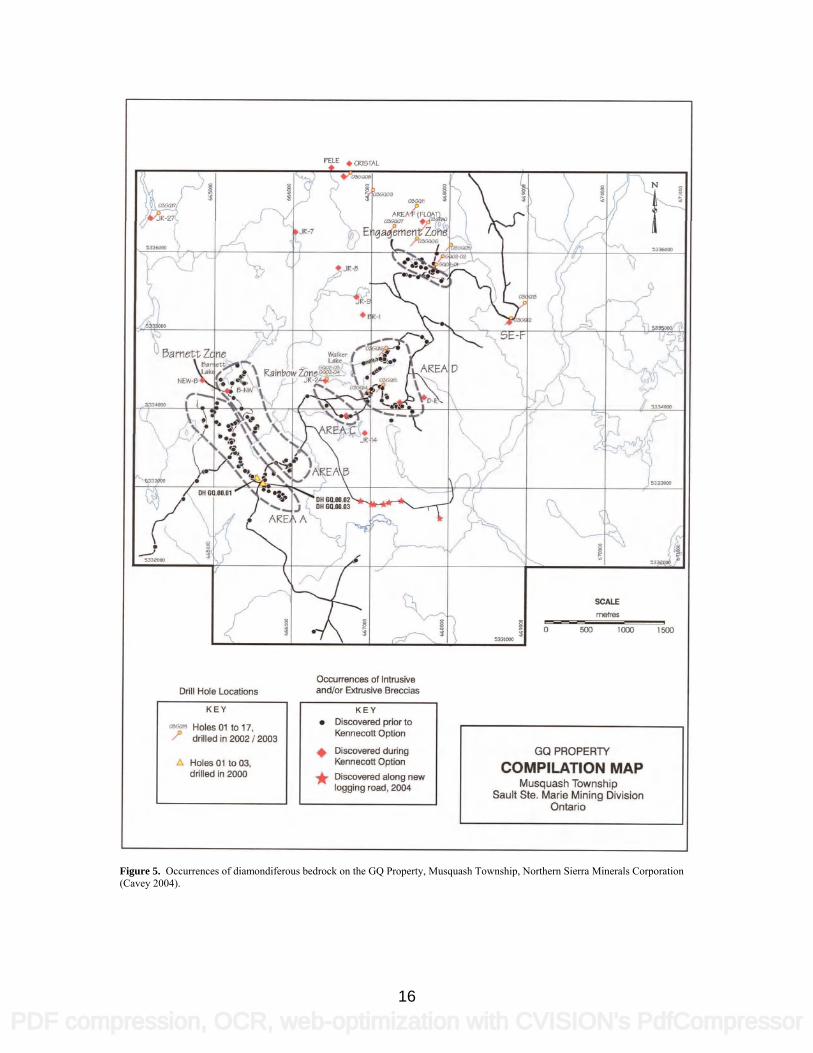
Engagement Zone Return to Highway 17 reset odometer 0 Drive north to access road – turn east 6.2 Park 6.6 Walk eastward along trail 7.6 4 Moet Occurrence, Festival Property 7.6 Return to Highway 17 reset odometer 0 Drive north, park on shoulder of highway 4.3 5 Sandor Diamond Occurrence 4.3 Continue north on Highway 17 to intersection of 12.6 Highway 519, turn right Safely turn in parking area and return to 0 Intersection of Hwy 17 and 519 reset odometer Drive south on Highway 17, park on shoulder of 3.1 road 6 Dubreuilville Dike 3.1 Continue south on Highway 17 44.9 Turn left into access road to gravel pit, park Walk south approximately 150 m 7 Monchiquite Dike 45 Drive north on Hwy 17 to Wawa 53.2 8 Wawa Motor Hotel STOP 1 - GQ Diamond Discovery Site Northern Sierra Minerals Corporation Area A UTM co-ordinates – 0665570E 5333291N NAD83 Several outcrops of diamondiferous breccia outcrop on the west side of a forestry road. This exposure is an example of the hypabyssal facies of the three identified diamond-bearing units. The rock cut displays the apparently conformable nature of these “lamprophyre” dikes. The most notable features of these outcrops are the actinolite-rich nature of the matrix and the presence of biotite-rich reaction rims around the xenoliths. It is frequently difficult to distinguish these dikes from the mafic to intermediate agglomeratic and tuffaceous host rocks. In the vicinity of the discovery area, located at the south end of Area A, the diamondiferous breccias are arrayed linearly along the logging road where the topography indicates a 5 – 10 m thick, northwest-trending dike (Cavey 2002). A compilation of the geology of the GQ Property is shown in figure 4. Figure 5 provides a compilation of the diamond occurrences on the GQ Property.
14
PDF compression, OCR, web-optimization with CVISION's PdfCompressor

GQ PROPERTY
I/I
'
AR!
I
GEOLOGY REVISED FROM CANADA EXPLORATION INC.
GABBRO
LIIMETASEDIMENTS
GO PROPERlYINTERMEDIATE TO FELSIC METAVOLCANICS PROPERTY GEOLOGY MAP
L CALCALKALINE IIVB AND LAMPROPIIYRE Sault Ste. Mane Mining DivisionOntario
LOCATIONS ARE APPROXIMATE Atter K. KM (2003), Kennecott
Figure 4. Geological compilation map of the GQ Property, Musquash Township, Northern Sierra Minerals Corporation (Cavey 2004).
15
PDF compression, OCR, web-optimization with CVISION's PdfCompressor
iT ________________ ____________
a
§
Occurrences ci In&usiveDrill Hde and/or Exinisive flreccias
KEY KEY• D;scovemdprlorto
Opthn
GO PROPERTYdrilled in 2002 I 2003
during
COMPILATION MAPa
MusquashTownshipdrilled in 2000
logging road. 2004
OntarioIt Ste. Marie Mirlfng Division
Figure 5. Occurrences of diamondiferous bedrock on the GQ Property, Musquash Township, Northern Sierra Minerals Corporation (Cavey 2004).
16
PDF compression, OCR, web-optimization with CVISION's PdfCompressor

A relatively precise 207Pb/206Pb age of 2674 ± 8 Ma was returned from a sample collected in 2000 by R. P. Sage (R. P. Sage, Ontario Geological Survey, unpublished 2000). The sample analysed was titanite. The titanite grains are considered to be a primary mineral and not xenocrystic. In thin section, the rock is characterized by a green, medium-grained, granoblastic to decussate groundmass of actinolite, biotite, chlorite, plagioclase and accessory minerals. Amphibole or biotite macrocrysts up to 1 mm are common (Stone and Semenyna 2004). Local prospectors T. Nicholson, J. Robert and M. Tremblay made the discovery in the fall of 1999. The first two bedrock samples (63.4 kg and 70.5 kg) collected were processed by Kennecott Canada Exploration Inc. in their Thunder Bay laboratory. According to Kennecott’s report, the 63.4 kg sample yielded 45 diamonds, of which 10 were macro diamonds and 35 were microdiamonds. One of the macro diamonds measured 1.01 mm in one dimension. The 70.5 kg sample yielded 9 microdiamonds. All stones were white in colour and transparent in clarity. Duplicate samples were collected by Band-Ore Resources Ltd. in early 2000 and were processed at SGS Lakefield Research Limited. A 54.6 kg sample yielded 98 microdiamonds. A confirmation sample from the same area yielded 98 microdiamonds from a 54.6 kg sample. In 2000, Band-Ore Resources drilled 3 short holes (75 m total) at the discovery site. Table 1 details the diamond recovery results from the drill program. Only partial intervals from drill hole DDH GQ-00-3 were submitted for microdiamond recovery since portions of the core were used for thin sections, microprobe analysis and display purposes. In total 5 diamonds were recovered from DDH GQ-00-3, including one champagne coloured macro diamond and one white microdiamond from a sample weighing 7.5 kg. Drill sections for DD GQ-00-01 through 03 are shown on figure 6. Table 1. Diamond recovery results from 2000 Band-Ore Resources Ltd. diamond-drilling program
Drill Hole Sample No. Sample Size (kg)
No. Macro Diamonds
No. Micro Diamonds
DDH GQ-00-1 Sample 1A 63.35 1 Sample 1B 30.17 10 Sample 1C 28.51 6
DDH GQ-00-2 Sample 2A 37.52 1 30 Sample 2B 30.97 434 Sample 2C 28.51 30
results compiled from Band-Ore Resources Ltd. press releases 2000 To date, the discovery site has yielded 746 diamonds, including 15 macro diamonds, from sample material weighing 785 kg. The largest diamond recovered exceeds 1.0 mm in size and the majority of the stones are gem quality, white, clear and transparent. STOP 2 - Northern Sierra Minerals Corporation Area B UTM co-ordinates – 0665425E 5334748N NAD83 The exposure on the east side of the forestry road provides an excellent exposure of the subvolcanic/intrusive breccia facies. Subrounded to rounded xenoliths dominate the vertical exposure (Figure 7). Field relationships between the intrusive breccia and other heterolithic breccias can be observed in several outcrops along the road. Texturally, the subvolcanic/intrusive facies may resemble both the hypabyssal facies and the intrusive heterolithic breccias. The facies consists of mica and amphibole phenocrysts (<2mm) in a groundmass of mica, actinolitic amphibole and lesser albite, carbonate, sphene and oxides. Alteration includes variably chloritized mica while the other phenocrysts have been extensively altered to varying proportions of mica, albite and actinolitic amphibole.
17
PDF compression, OCR, web-optimization with CVISION's PdfCompressor

zQ
000
MAFICVOLCAXICS /
A
S\\IPI IlB -,
Band-Ore Resources Ltd.
MARCVOLCANICS
/
GQ PROPERTY
Drill Section
Musquash Township 3Dm
Ste. Marie Mining DivisionOntario
Drill Hole GQ-OO-O1
Section Looking West
Figure 6. Drill hole sections GQ-00-01, GQ-00-02 and GQ-00-03, GQ Property, Musquash Township, Northern Sierra Minerals Corporation (Cavey 2002).
18
PDF compression, OCR, web-optimization with CVISION's PdfCompressor

SAM PLI- microdinmonds XENOLITHIC
A (33.81kg) 3 macrodiamonds DIATREME
00)
2A (3 7.52kg)
/XYN(YLITIIICDI.\I
I
2B
7GQ-OO-03 S\\IPLI -
2€
4,
Band-Ore Resources Ltd.GQ-OO-02
GQ PROPERTY27m
Drill Section
Musquash TownshipSault Ste. Marie Mining Division
Ontario
Drill Holes G-OO-2 and GQ-OO-03
Section Looking West
Figure 6 cont’d. Drill hole sections GQ-00-01, GQ-00-02 and GQ-00-03, GQ Property, Musquash Township, Northern Sierra Minerals Corporation (Cavey 2002).
19
PDF compression, OCR, web-optimization with CVISION's PdfCompressor

. —II-
- - ½
.t •q"-
—.-..'4
- Ip(
Figure 7. Stop 2 - Northern Sierra Minerals Corporation Area B – rounded lower crustal to upper mantle xenoliths Stone and Semenyna (2004) completed a petrographic examination of one of the ultramafic xenoliths from this site. The sample was dominated by a coarse, radiating to decussate, clear to pale green amphibole of tremolitic to magnesium-rich actinolite composition. Carbonate occurs locally and biotite is concentrated at the rims of the xenolith. Band-Ore Resources Ltd. discovered area B in 2000. Thirty-three (33) reconnaissance samples were collected from this area and a total of 273 diamonds was recovered from 352 kg of material (Cavey 2002). One 24 kg sample returned 126 microdiamonds (1.37 mg total weight). No macro diamonds were recovered from Area B. Band-Ore Resources Ltd. completed only a reconnaissance sampling program, minor stripping and trenching in this area. The Barnett Zone lies approximately 1.6 km to the northwest. It was discovered in the fall of 2001 by Kennecott Canada Exploration Inc. who completed a limited program of mechanical stripping, channel sampling and washing of outcrops over the area. A total of 27 outcrop channel samples (270 kg) were collected. The channel samples returned 330 microdiamonds and 3 macro diamonds. A single 24 kg sample of heterolithic breccia from the Barnett Zone returned 3 macrodiamonds and 123 microdiamonds. A total of 273 diamonds (261 microdiamonds and 12 macrodiamonds) were recovered from 34 samples (352 kg) collected between September 2000 and July 2001 by Kennecott Canada Exploration Inc. in Area B (including the Barnett Zone).
20
PDF compression, OCR, web-optimization with CVISION's PdfCompressor

STOP 3 - Northern Sierra Minerals Corporation Engagement Zone Bulk Sample Site UTM co-ordinates – 0667760E 5336073N NAD83 The main outcrop exposure consists of medium to thickly bedded pyroclastic air-fall deposits and debris flows described as heterolithic tuff-breccias that grade upwards to lapilli-tuff and tuff. The groundmass of the extrusive phase is fine-grained with variable proportions of relatively small (<2mm) altered phenocrysts, including chloritized mica. The groundmass consists primarily of actinolitic amphibole with rare to minor mica or granular albite. The pyroclastic rocks are mineralogically and compositionally similar to intrusive varieties, but have a significantly higher proportion of mica phenocrysts. Both diamond-bearing intrusive and extrusive rocks host significant proportions of fragments derived from the local country rock. Rare to minor, deep crustal and upper mantle xenoliths, such as banded gneiss and extensively altered talcose ultramafic xenoliths are present. Fresh mantle rocks, such as lhertzolite, harzburgite and eclogite have not been identified. The matrix material is typically fine-grained, green, weakly foliated actinolite schist. Albite is present, although it is less abundant (<10%) than in the lamprophyre dikes and implies a more ultramafic composition for the breccia matrix than for the lamprophyre dikes. Titanite is fairly abundant and calcite, epidote, apatite and sulphide minerals occur locally. Macrocrysts of actinolite are commonly observed. Rare macrocrysts of amphibole also are observed and are frequently altered to actinolite. The actinolite macocrysts are probably metamorphic in origin, whereas the amphibole macrocrysts may represent accidental or cognate crystals (Stone and Semenyna 2004). The Engagement Zone has a minimum strike length of 335 m and a horizontal width in excess of 75m. The zone strikes northwesterly and has a shallow dip to the northeast. This zone may represent the southeast extension of Pele Mountain Resources Inc.’s Cristal diamond occurrence located approximately 2 km to the northwest. In 2003, a 0.72 carat macrodiamond was recovered from a bulk sample collected from the Cristal. The geology of the Engagement Zone and sample locations are shown in Figure 8. A simplified cross section of the Engagement Zone is shown in Figure 9. Band-Ore Resources Ltd. discovered this zone in January 2001. A 16 kg sample from a single angular boulder of diatreme breccia returned 128 microdiamonds. Four subsequent samples (96 kg total weight) returned 5045 microdiamonds and 65 macrodiamonds. In 2001 a mini-bulk sample weighing 12.5 tonnes was collected under the supervision of Kennecott Canada Exploration Inc. and shipped to the Saskatchewan Research Council. The largest diamond recovered from this sample was a 0.254 carat, broken, white octahedral stone. Two additional bulk samples were collected in 2003. A 22 tonne sample tested an area where 6 channel samples (63 kg total) recovered 1752 stones. A 20 tonne sample tested an area where 5 channel samples weighing 41.8 kg returned 552 stones. The results from these bulk samples are shown in Table 2. Table 2. Diamond results from Engagement Zone bulk samples (2001)
Occurrence Sample Weight Sieve +1mm Sieve +2mm Sieve +3mm Sieve +5mm Sieve +6mm Total
Diamonds Total Carat
Weight
Engagement Zone East
22.1 tonnes 1 4 4 2 1 12 0.375
Engagement Zone West
20.4 tonnes 2 3 3 8 0.155
results compiled from Band-Ore Resources Ltd. press releases 2004 To date, exploration on the Engagement Zone has included an orientation geochemical survey, geological mapping, channel sampling, trenching, bulk sampling and a 9-hole (1775 m) diamond drilling program designed to test the strike continuation of the zone. The drilling program demonstrated that thick diamondiferous breccia deposits can feather out and thin to a few centimeters thickness (Cavey 2003).
21
PDF compression, OCR, web-optimization with CVISION's PdfCompressor

C
Engagement Zone // N
1/II
APPARENT OUTLINE OF / /
0
//MICROS
73 MACROSFROM 481.83ii I -
// excludes the resuj
/ from the KenneecII channel sampling
V
\ I
Mt.51262I
12 tonne Exploration Sample hz' - - - - '.APPROX. DII'O.2o4CaratWhrtsOctahedral -. /y
LOG A1FONØ ARE
APP ROXIM
so icc
Engagement Zone
• OCCURRENCES OF BRECCIA
large angular slabs and/or Duicrop)
* SAMPLE PROCESSED FOR MICRODIAMOND RECOVERY
(caustic fusion)
Figure 8. Stop 5 – Geology and sample locations at the Engagement Zone, GQ Property, Northern Sierra Minerals Corporation (Cavey 2002)
22
PDF compression, OCR, web-optimization with CVISION's PdfCompressor
2001 MINI-DULK SAMPLE
A
SIRIFFLNG N
NVOLCAN NMEGALITH
HETEKOLtIHIC
VOLCAN[CLAST:C
CC IA
N4AFLC VOLCANICS ANDINIERELOW
— VOLGAN[CI "NN •I105,
NHETEWLFIHICIN
NN SKECCIA
LOCATIONS ArFROX!MATE "N
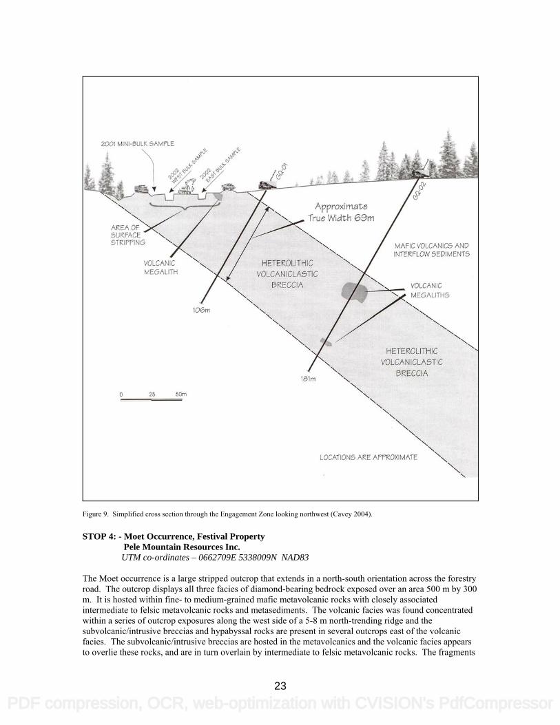
Figure 9. Simplified cross section through the Engagement Zone looking northwest (Cavey 2004). STOP 4: - Moet Occurrence, Festival Property Pele Mountain Resources Inc. UTM co-ordinates – 0662709E 5338009N NAD83 The Moet occurrence is a large stripped outcrop that extends in a north-south orientation across the forestry road. The outcrop displays all three facies of diamond-bearing bedrock exposed over an area 500 m by 300 m. It is hosted within fine- to medium-grained mafic metavolcanic rocks with closely associated intermediate to felsic metavolcanic rocks and metasediments. The volcanic facies was found concentrated within a series of outcrop exposures along the west side of a 5-8 m north-trending ridge and the subvolcanic/intrusive breccias and hypabyssal rocks are present in several outcrops east of the volcanic facies. The subvolcanic/intrusive breccias are hosted in the metavolcanics and the volcanic facies appears to overlie these rocks, and are in turn overlain by intermediate to felsic metavolcanic rocks. The fragments
23
PDF compression, OCR, web-optimization with CVISION's PdfCompressor
Stop4 t' Moot -5—— -/
I
1YPE I\">" —
— M.lic rock. + an&'o
—reck, tomainjin mamle xpnnMha
cpsTs
0
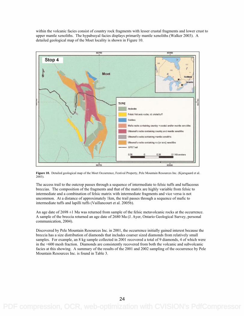
within the volcanic facies consist of country rock fragments with lesser crustal fragments and lower crust to upper mantle xenoliths. The hypabssyal facies displays primarily mantle xenoliths (Walker 2003). A detailed geological map of the Moet locality is shown in Figure 10.
Figure 10. Detailed geological map of the Moet Occurrence, Festival Property, Pele Mountain Resources Inc. (Kjarsgaard et al. 2003). The access trail to the outcrop passes through a sequence of intermediate to felsic tuffs and tuffaceous breccias. The composition of the fragments and that of the matrix are highly variable from felsic to intermediate and a combination of felsic matrix with intermediate fragments and vice versa is not uncommon. At a distance of approximately 1km, the trail passes through a sequence of mafic to intermediate tuffs and lapilli tuffs (Vaillancourt et al. 2005b). An age date of 2698 ±1 Ma was returned from sample of the felsic metavolcanic rocks at the occurrence. A sample of the breccia returned an age date of 2680 Ma (J. Ayer, Ontario Geological Survey, personal communication, 2004). Discovered by Pele Mountain Resources Inc. in 2001, the occurrence initially gained interest because the breccia has a size distribution of diamonds that includes coarser sized diamonds from relatively small samples. For example, an 8 kg sample collected in 2001 recovered a total of 9 diamonds, 4 of which were in the +600 mesh fraction. Diamonds are consistently recovered from both the volcanic and subvolcanic facies at this showing. A summary of the results of the 2001 and 2002 sampling of the occurrence by Pele Mountain Resources Inc. is found in Table 3.
24
PDF compression, OCR, web-optimization with CVISION's PdfCompressor
Table 3. Summary of the diamond results from the 2001-02 sampling of the Moet Occurrence
Facies Weight (kg) <425 mesh >425 mesh total diamonds
volcanic 117 48 0 48 volcanic 16 2 1 3 hypabyssal 24 0 0 0 hypabyssal 8.6 0 0 0 volcanic 9.3 7 0 7 volcanic 14.1 12 5 17 hypabyssal 9.3 0 0 0 subvolcanic breccia 32 30 1 31
results compiled from Pele Mountain Resources Inc. press releases 2002 Further exploration was conducted at the occurrence in 2003 when DeBeers Canada Exploration Inc. completed a detailed airborne geophysical survey, stripping, mapping and sampling program. A 47.8-tonne bulk sample from the site returned 5 diamonds with a total carat weight of 0.13. All diamonds were recovered from the +1 to +3 sieve class screens (Pele Mountain Resources Inc., press release, March 17, 2004). STOP 5: - Sandor Diamond Occurrence Spider Resources Inc. & KWG Resources Inc. UTM co-ordinates – 0659805E 5342191N NAD83 The Sandor occurrence the first confirmed occurrence of diamonds in bedrock in the Wawa area The occurrence is located in a 4 m high road cut on the east side of the Trans Canada Highway (Highway 17). The dike is approximately 5 m wide, steeply dipping and strikes roughly parallel to the regional schistosity at 120°. The dark, greenish-grey rock weathers olive grey, is highly fractured, moderately carbonatized and is non-magnetic. It is composed of up to 40% actinolite replaced mantle xenoliths and supracrustal xenoliths. Towards the margins of the dike xenoliths are less common and the rock grades into an adjacent micaceous dike. Only remnants of the dike remain in situ. The dike is hosted by gabbros and intermediate to felsic crystal tuffs. A (308.6 kg) sample of the dike, collected by Spider Resources Inc. in 1997, returned a total of 97 diamonds comprising 1 commercial stone, 13 macrodiamonds and 83 microdiamonds. A short walk into the forest from the top of the outcrop leads to a larger stripped area where field relationships between the host gabbro and the dike can be observed. A second, xenolith-bearing dike (occurrence LAL-3) is located at the north end of the outcrop. This dike is 2 m wide and closely resembles the Sandor occurrence. A 34.6 kg sample of this dike contained 1 microdiamond. A detailed geological map of the Sandor occurrence is shown in Figure 11. A compilation map of the geology of the Spider Resources Inc. and KWG Resources Inc. property is shown in Figure 12. Using normative mineralogy, Sage (2000) concluded that this dike should be classified as a spessartite. A spessartite is defined as a lamprophyre composed of phenocrysts of green hornblende or clinopyroxene in a groundmass of sodic plagioclase with accessory olivine, biotite, apatite and opaque oxides. Titanite and rutile from the matrix of the Sandor dike returned an age of 2703 ± 42 Ma (Sage 2000). The date is interpreted to be a minimum age of intrusion. Subsequent dating of a zircon from a gneissic xenolith from the Sandor dike returned a 207Pb/206Pb age of 2684.9 ± 1.4 Ma (Ketchum, Kamo and Davis 2003). Spider Resources Inc. and joint venture partner KWG Resources Inc. have taken 3 mini-bulk samples along the 1 km strike extent of the dike since the fall of 2001. The three bulk samples had a combined weight of 7.61 tonnes and returned 11 commercial stones and 9 macro diamonds. These samples were tested only for macro diamond and commercial diamond content (Spider Resources Inc., press releases, February and March 2002).
25
PDF compression, OCR, web-optimization with CVISION's PdfCompressor

0
' -— M*VSc.iic
—tbcoveryOflop
-
——-Opel—
S2__21'
Stops
Figure 11. Detailed geology of the Sandor Occurrence, Spider Resources Inc. & KWG Resources Inc. (Kjarsgaard et al. 2003).
Figure 12. Generalized geology of Wawa Project, Spider Resources Inc. and KWG Resources Inc. (Spider Resources Inc. and KWG Resources Inc., CD-ROM presentation, update February 24, 2004)
26
PDF compression, OCR, web-optimization with CVISION's PdfCompressor
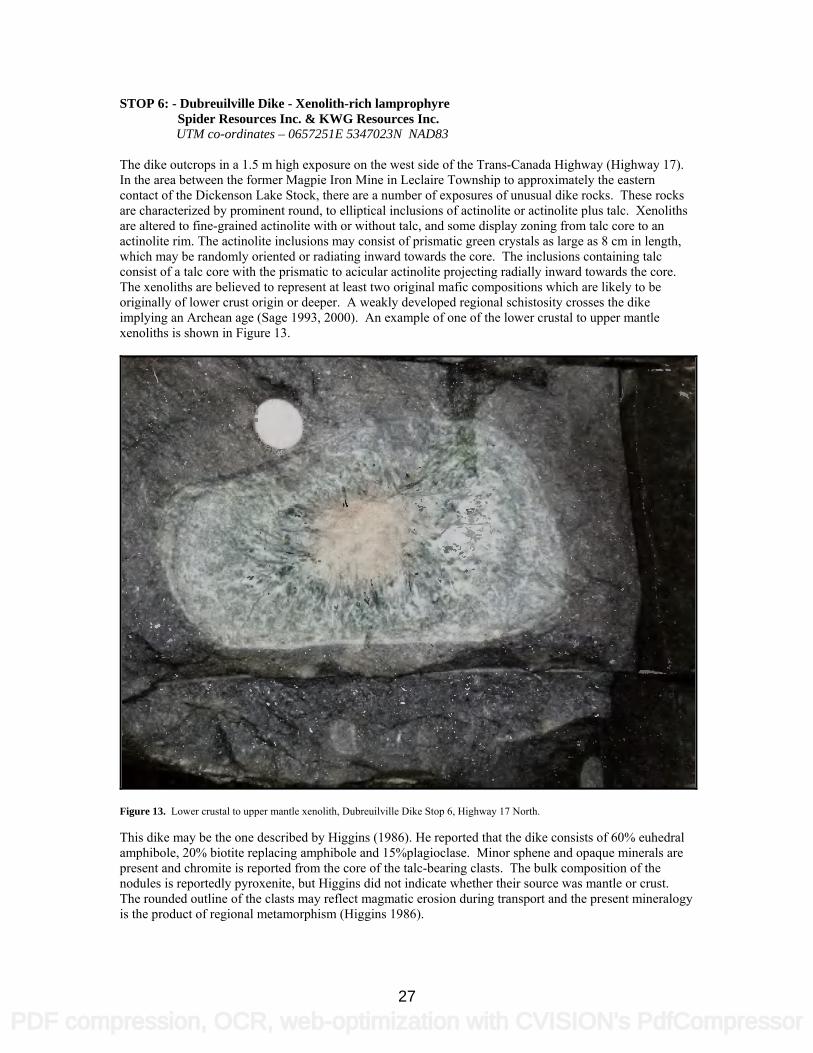
STOP 6: - Dubreuilville Dike - Xenolith-rich lamprophyre Spider Resources Inc. & KWG Resources Inc. UTM co-ordinates – 0657251E 5347023N NAD83 The dike outcrops in a 1.5 m high exposure on the west side of the Trans-Canada Highway (Highway 17). In the area between the former Magpie Iron Mine in Leclaire Township to approximately the eastern contact of the Dickenson Lake Stock, there are a number of exposures of unusual dike rocks. These rocks are characterized by prominent round, to elliptical inclusions of actinolite or actinolite plus talc. Xenoliths are altered to fine-grained actinolite with or without talc, and some display zoning from talc core to an actinolite rim. The actinolite inclusions may consist of prismatic green crystals as large as 8 cm in length, which may be randomly oriented or radiating inward towards the core. The inclusions containing talc consist of a talc core with the prismatic to acicular actinolite projecting radially inward towards the core. The xenoliths are believed to represent at least two original mafic compositions which are likely to be originally of lower crust origin or deeper. A weakly developed regional schistosity crosses the dike implying an Archean age (Sage 1993, 2000). An example of one of the lower crustal to upper mantle xenoliths is shown in Figure 13.
Figure 13. Lower crustal to upper mantle xenolith, Dubreuilville Dike Stop 6, Highway 17 North. This dike may be the one described by Higgins (1986). He reported that the dike consists of 60% euhedral amphibole, 20% biotite replacing amphibole and 15%plagioclase. Minor sphene and opaque minerals are present and chromite is reported from the core of the talc-bearing clasts. The bulk composition of the nodules is reportedly pyroxenite, but Higgins did not indicate whether their source was mantle or crust. The rounded outline of the clasts may reflect magmatic erosion during transport and the present mineralogy is the product of regional metamorphism (Higgins 1986).
27
PDF compression, OCR, web-optimization with CVISION's PdfCompressor

STOP 7: - Monchiquite Dike Michipicoten Post Provincial Park UTM co-ordinates – 0663600E 5309223N NAD83 On the west side of Trans Canada Highway (Highway 17) two, 1-metre wide and one, 3-metre wide monchiquite dikes outcrop at the base of a 3 m high outcrop. The dikes are parallel, strike 060° and crosscut a portion of the Mission Stock. A 4 m wide, east-trending microsyenite dike also can be observed cutting the granodiorite and the monchiquite at this location. The north-northwest-trending Trembley Fault cuts across the north end of the outcrop (Massey 1985). These lamprophyres are most commonly seen in road cuts along the highway and along the shore of Lake Superior. Typically, they are black when fresh and weather to an orange-brown colour. The dikes are usually narrow and are typically less than 1 m wide. Biotite-phyric and olivine-phyric varieties are most common, but pyroxene and feldspar phenocrysts also are observed. Often the dikes show evidence of multiple and composite intrusion, sometimes with tin screens of country rock trapped within the dikes. Lamprophyre dikes south of the Michipicoten River typically have a northeast trend (Massey 1985). Lamprophyre dikes are commonly found cross cutting all lithologies south of the Wawa – Hawk –Manitowik Lakes Fault. Because of their ease of weathering they are infrequently seen in outcrop. However, the dikes are frequently found in underground mine workings. These dikes have a number of macrocrystic resemblances to the dikes seen here. As early as 1927, geologists working in the area had noted a similarity between these lamprophyre dikes and kimberlite (Gledhill 1927). Recent petrographic and mineralogical studies on several dikes in both McMurray and Lendrum townships have suggested that some of the geochemistry falls within the classification of type II kimberlites (orangeites) (Barnett 2001). To date, no diamonds have been recovered from these dikes. These lamprophyre dikes are probably Proterozoic in age and are interpreted to represent Proterozoic alkalic magma emplacement into structures related to the Kapuskasing Structural Zone, perhaps consanguineous with the nearby Firesand Creek carbonatite complex. Rocks from the Firesand Creek carbonatite complex have a U-Pb date of 1078 ± 2.4 Ma (Sage 2000). STOP 8: - Contemplation of the rocks on the fireplace at the Wawa Motor Hotel Acknowledgments The author would like to thank Wayne O’Connor, Northern Sierra Minerals Corporation, Al Shefsky, President, Pele Mountain Resources Inc. and Neil Novak, Vice-President of Exploration, Spider Resources Inc. for permission to access properties described in the field guide. Editorial comments by R. P. Sage also were appreciated during the preparation of the field guide. My thanks also go to Glenn Seim for his technical assistance in the preparation of the guidebook.
28
PDF compression, OCR, web-optimization with CVISION's PdfCompressor
Bibliography Arias, Z. G. 1996. Structural evolution of the central Michipicoten greenstone belt, Superior Province, Wawa, Ontario, Canada;
unpublished MSc thesis, Queen’s University, Kingston, Ontario, 140p. Arias, Z. G. and Helmstaedt, H. 1990. Structural evolution of the Michipicoten (Wawa) greenstone belt, Superior Province: Evidence
for an Archean fold and thrust belt; in Geoscience Research Grant Program, Summary of Research 1989-1990, Ontario Geological Survey, Miscellaneous Paper 150, p. 107-114.
Ayer, J. A., Conceição, R. V., Ketchum, J. W. F., Sage, R. P., Semenyna, L. and Wyman, D. A. 2003. The timing and petrogenesis of
diamondiferous lamprophyres in the Michipicoten and Abitibi greenstone belts; in Summary of Field Work and Other Activities 2003, Ontario Geological Survey, Open File Report 6120, p. 10-1 to 10-9.
Barnett, R. L. 2001. Fletch Kimberlite correspondence, Report of Work, Matchinameigus and Fletch Properties, Dolson & Echum
Townships, Sault Ste Marie Mining Division, Northern Ontario; Timmins Resident Geologist’s Office, Dolson Township, assessment file WP–Dolson–4, unpaginated.
Cavey, G. 2002. Geological report on the Wawa properties for Band-Ore Resources Ltd. Sault Ste Marie Mining Division, Ontario;
unpublished NI 43-101 report, 50p. Cavey, G. 2003. Updated geological report on the Wawa property for Band-Ore Resources Ltd. Sault Ste Marie Mining Division,
Ontario; unpublished NI 43-101 report, 35p. Cavey, G. 2004. Summary geological report on the GQ Property for Band-Ore Resources Ltd. Sault Ste Marie Mining Division,
Ontario; unpublished NI 43-101 report, 39p. Corfu, F. and Sage R. 1987. A precise U-Pb zircon age for a trondhjemite clast in Doré conglomerate, Wawa, Ontario; in Proceedings
and Abstracts, Institute on Lake Superior Geology Annual Meeting, v. 33, p. 18. Corfu, F. and Sage, R. 1992. U-Pb age constraints for deposition of clastic metasedimentary rocks and late-tectonic plutonism,
Michipicoten belt, Superior Province; Canadian Journal of Earth Sciences, v. 29, p. 1640-1651. De Stefano, A., Lefebvre, N. and Kopylova, M. 2006. Enigmatic diamonds in Archean calc-alkaline lamprophyres of Wawa, southern
Ontario, Canada; Contributions to Mineralogy and Petrology, on-line edition, January 5, 2006. Gledhill, T. L. 1927. Michipicoten Gold Area, District of Algoma; Ontario Department of Mines, Annual Report, 1927, v. 36, pt. 2, p.
1-49. Higgins, M. D. 1986. Nodule-bearing spessartite (lamprophyre) dike near Wawa, Northern Ontario; in Program with Abstracts GAC-
MAC-GCU-AGC-AMC-UCG, vol. 11, p. 81. Kaminsky, F. V., Sablukov, S. M., Sablukova, L. I, Shchukin, V. S. and Canil, D. 2002. Kimberlites from the Wawa area; Canadian
Journal of Earth Sciences, v. 39, p. 1819-1838. Ketchum, J., Kamo, S. and Davis, D. 2003. U-Pb ages from the Superior and Grenville Provinces of Ontario; unpublished report of
the Jack Satterly Geochronology Laboratory, Toronto. Kjarsgaard, B. A., McClenaghan, M. B., Boucher, D. R. and Kivi, K. 2003. Kimberlites and ultrabasic rocks of the Wawa, Chapleau,
Kirkland Lake and Lake Timiskaming Areas; in VIIIth International Kimberlite Conference, Northern Ontario Field Trip Guidebook, B. A. Kjarsgaard (ed) p. 1-37.
Lefebvre, N. S. 2004. Petrology, volcanology, and diamonds of Archean calc-alkaline lamprophyres, Wawa, Ontario, Canada;
unpublished MSc thesis, The University of British Columbia, Vancouver, British Columbia, 265 p. Lefebvre, N., Kopylova, M., Kivi, K. and Barnett, R. 2003. Diamondiferous volcaniclastic debris flows of Wawa, Ontario Canada;
long abstract prepared for VIIIth International Kimberlite Conference, Victoria, British Columbia, Canada. Massey, N. W. D.1985. Geology of the Mishewawa Lake Area, District of Algoma; Ontario Geological Survey, Open File Report
5532, 167p. Morris, T. F. 1999. Overburden as a media for kimberlite, base metal and gold exploration, Wawa region, northeastern Ontario;
Geological Association of Canada – Mineralogical Association of Canada, Joint Annual Meeting, GAC-MAC Sudbury 1999, Field Trip B6 guidebook, 67p.
Morris, T. F. 2001. Quaternary geology of the Wawa Area, Northeastern Ontario; Ontario Geological Survey, Open File Report 6055,
67p.
29
PDF compression, OCR, web-optimization with CVISION's PdfCompressor

Sage, R. P. 1993. Geology of Killins, Knicely and Lalibert townships, District of Algoma; Ontario Geological Survey, Open File Report 5589, 141p.
Sage, R. P. 1994. Geology of the Michipicoten greenstone belt; Ontario Geological Survey, Open File Report 5888, 592p. Sage, R. P. 2000. The “Sandor” diamond occurrence, Michipicoten greenstone belt, Wawa, Ontario: A preliminary study; Ontario
Geological Survey, Open File Report 6016, 49p. Sage, R. P., England, D., Calvert, T., Oudkerk, G., Worona, R. and Kusciusko, R. 1982. Precambrian geology of Musquash
Township, Algoma District; Ontario Geological Survey, Map P.2556, scale 1:15 840. Stachel, T., Blackburn, L., Kurszlaukis, S., Barton, E. and Walker, E. C. 2004. Diamonds from the Cristal and Genesis volcanics,
Wawa area, Ontario; in Abstracts of Talks & Posters, 32nd Annual Yellowknife Geoscience Forum, 16-18 November 2004, p. 74-75.
Stone, D. and Semenyna, L. 2004. Petrography, chemistry and diamond characteristics of heterolithic breccia and lamprophyre dikes
at Wawa, Ontario; Ontario Geological Survey, Open File Report 6134, 39p. Stott, G. M., Ayer, J. A., Wilson A. C. and Grabowski, G. P. B. 2002. Are Neoarchean diamond-bearing breccias in the Wawa area
related to late-orogenic alkalic and “sanukitoid” intrusions?; in Summary of Field Work and Other Activities 2002, Ontario Geological Survey, Open File Report 6100, p. 9-1 to 9-10.
Turek, A., Sage, R. P. and Van Schmus, W. R. 1992. Advances in the U-Pb ziron geochronology of the Michipicoten greenstone belt
near Wawa, Ontario; Canadian Journal of Earth Sciences, v. 27, p. 649-656. Vaillancourt, C., Ayer, J. A., Zubowski, S. M. and Kamo, S. L. 2004. Synthesis and timing of Archean geology and diamond-bearing
rocks in the Michipicoten Greenstone Belt: Menzies and Musquash townships; in Summary of Field Work and Other Activities 2004, Ontario Geological Survey, Open File Report 6145, p. 6-1 to 6-9.
Vaillancourt, C., Ayer, J. A. and Hamilton, M. A. 2005a. Synthesis of Archean geology and diamond-bearing rocks in the
Michipicoten greenstone belt: Results from microdiamond extraction and geochronological analyses; in Summary of Field Work and Other Activities 2005, Ontario Geological Survey, Open File Report 6172, p. 8-1 to 8-11.
Vaillancourt, C., Dessureau, G. R. and Zubowski, S. M. 2005b. Precambrian geology of Menzies Township; Ontario Geological
Survey, Preliminary Map P.3366, scale 1:20 000 Vaillancourt, C., Zubowski, S. M. and Dessureau, G. R. 2005c. Lithogeochemical data and field photographs for the Wawa area:
Menzies and Musquash Townships; Ontario Geological Survey, Miscellaneous Release – Data 151. Walker, E. C. 2002. Diamond deposits of the Festival Property, Wawa, Ontario; Report prepared for Pele Mountain Resources Inc.
under National Instrument 43-101, 41p. Walker, E. C. 2003. Diamond deposits of the Festival Property, Wawa, Ontario; Report prepared for Pele Mountain Resources Inc.
under National Instrument 43-101, 39p. Williams, F. 2002. Diamonds in late Archean calc-alkaline lamprophyres Ontario, Canada: Origins and implications; unpublished
BSc thesis, University of Sydney, Sydney, Australia, 82 p. Wilson, A. C. 2004. Diamond exploration targets, Michipicoten greenstone belt; Canadian Institute of Mining Bulletin, v. 97, no.
1077, p. 41-46. Wyman, D. A., Ayer, J. A., Conceição, R. V., and Sage, R. P. in press. Mantle processes in an Archean orogen: evidence from 2.67
Ga diamond-bearing lamprophyres and xenoliths, Lithos.
30
PDF compression, OCR, web-optimization with CVISION's PdfCompressor