UNIVERSITY OF CALGARY Procession Ritual at Naachtun ...
206
UNIVERSITY OF CALGARY Procession Ritual at Naachtun, Guatemala During the Late Classic Period by Shawn Gregory Morton A THESIS SUBMITTED TO THE FACULTY OF GRADUATE STUDIES IN PARTIAL FULFILMENT OF THE REQUIREMENTS FOR THE DEGREE OF MASTER OF ARTS DEPARTMENT OF ARCHAEOLOGY CALGARY, ALBERTA JANUARY, 2007 © Shawn Gregory Morton 2007
Transcript of UNIVERSITY OF CALGARY Procession Ritual at Naachtun ...

UNIVERSITY OF CALGARY
Procession Ritual at Naachtun, Guatemala During the Late Classic Period
by
Shawn Gregory Morton
A THESIS
SUBMITTED TO THE FACULTY OF GRADUATE STUDIES
IN PARTIAL FULFILMENT OF THE REQUIREMENTS FOR THE
DEGREE OF MASTER OF ARTS
DEPARTMENT OF ARCHAEOLOGY
CALGARY, ALBERTA
JANUARY, 2007
© Shawn Gregory Morton 2007


iii
Abstract
In general this thesis is concerned with procession ritual in the Maya Classic
period. At a deeper level I attempt to discuss the complex relationships between the
natural and the supernatural landscapes so prevalent in the ethnographic record and the
ways in which procession ritual could have been used to negotiate these landscapes in the
Classic context. To this end I ask three questions: 1) What spatial and symbolic
characteristics were required of the built environment for the successful completion of a
procession ritual? 2) How were society, politics, religion and ritual interrelated, and how
specifically could the act of ritual procession relate to these interactions? 3) Can
evidence be seen for procession ritual archaeologically and what can be suggested of it in
the context of Naachtun? I use the site plan and political, social, and cosmological
landscapes of central, Late Classic Naachtun, Guatemala as the context for this
discussion.

iv
Acknowledgements
This thesis was made possible through funding provided by the Social Sciences
and Humanities Research Council of Canada, the University of Calgary, and the
Department of Archaeology at the University of Calgary. Those who provided support
and guidance are numerous and I apologize at the outset if I fail to include anyone. I
would like to thank all of those people in the Department of Archaeology, my supervisor
Kathryn Reese-Taylor and all those I called on for input, Geoff McCafferty, Gerry
Oetelaar, Peter Dawson, and Karen Bassie-Sweet. I would also like to acknowledge the
students in the department for affording a completely enjoyable experience filled with
fast friends, a lot of laughs, and more advice than any man could bear (Jode, Beau, Kyle,
Sean). Thanks, of course, go to Chops, my parents Greg and Wendy, my brother
Andrew, and Meaghan; I’m sorry for chewing your ears off, maybe now we can talk
about something else.

v
Table of Contents
Approval Page..................................................................................................................... ii
Abstract .............................................................................................................................. iii
Acknowledgements............................................................................................................ iv
List of Tables ................................................................................................................... viii
List of Figures and Illustrations ......................................................................................... ix
Epigraph............................................................................................................................ xii
CHAPTER ONE: INTRODUCTION AND RESEARCH OBJECTIVES..........................1
1.1 Introduction................................................................................................................1
1.2 Previous Work ...........................................................................................................2
1.3 Research Objectives...................................................................................................3
1.4 Organization of this Discussion.................................................................................6
1.4.1 Section One .......................................................................................................7
1.4.2 Section Two.......................................................................................................8
CHAPTER TWO: THE MAYA AREA AND THE GEOGRAPHICAL SETTING OF
NAACHTUN ............................................................................................................10
2.1 Introduction..............................................................................................................10
2.2 The Maya Area ........................................................................................................10
2.2.1 The Pacific Coastal Plain and Piedmont .........................................................11
2.2.2 The Highlands .................................................................................................11
2.2.3 The Lowlands ..................................................................................................12
2.3 The Setting of Naachtun ..........................................................................................14
CHAPTER THREE: A FRAMEWORK FOR INVESTIGATING SITE PLANS............17
3.1 Introduction..............................................................................................................17
3.2 Maya Cosmography.................................................................................................17
3.2.1 Nodes Between Worlds ...................................................................................20
3.2.2 The Role of Ritual ...........................................................................................23
3.3 Maya Social Organization .......................................................................................25
3.4 Maya Political Organization ....................................................................................28
3.5 Approaches to the Study of Site Plans in the Maya Area........................................33
3.5.1 Topographic Considerations............................................................................34
3.5.2 Functional Considerations ...............................................................................35
3.5.3 Cosmological Considerations..........................................................................35
3.5.4 Socio-Political Considerations ........................................................................40
3.5.4.1 Ethnic Plaza Plan and Replicated Plaza Approaches.............................41
3.6 Discussion................................................................................................................43
3.7 Space Syntax............................................................................................................44
3.7.1 Axial Line Analysis.........................................................................................46
3.8 Archaeological Applications of Space Syntax.........................................................47
3.9 Axial Line Analysis as Applied in this Thesis.........................................................49
3.10 Discussion..............................................................................................................50

vi
CHAPTER FOUR: THE SURVEY, INTERPRETATION, AND
REPRESENTATION OF NAACHTUN. .................................................................51
4.1 Introduction..............................................................................................................51
4.2 Previous Archaeological Work at Naachtun............................................................52
4.3 The Survey Program at Naachtun............................................................................54
4.3.1 Referencing the Site ........................................................................................55
4.3.2 Establishing Datums (Survey Stations) ...........................................................57
4.3.3 Laying out the Site...........................................................................................60
4.3.3.1 Group A .................................................................................................60
4.3.3.2 Group B..................................................................................................61
4.3.3.3 Group C..................................................................................................61
4.3.4 Surveying Open Space ....................................................................................61
4.3.5 Surveying Structures .......................................................................................62
4.3.6 Mapping Monuments.......................................................................................62
4.4 Generating the Maps................................................................................................64
4.5 Classic Period Architecture .....................................................................................64
4.6 Types of Maya Architecture ....................................................................................66
4.6.1 The Void/Open Space......................................................................................67
4.6.1.1 The Plaza................................................................................................67
4.6.1.2 The Courtyard ........................................................................................69
4.6.1.3 The Terrace ............................................................................................69
4.6.1.4 The Platform ..........................................................................................72
4.6.1.5 The Causeway/Sacbe .............................................................................74
4.6.1.6 The Ballcourt .........................................................................................74
4.6.2 Structures.........................................................................................................75
4.6.2.1 The Temple ............................................................................................75
4.6.2.2 The Palace..............................................................................................77
4.6.2.3 The Ballcourt .........................................................................................77
4.6.2.4 The Stela ................................................................................................79
4.7 Drawing the Rectilinear Map...................................................................................81
4.8 Preparing an Axial Map...........................................................................................83
4.9 Discussion................................................................................................................88
CHAPTER FIVE: THE PHYSICAL AND SYMBOLIC ARCHITECTURE OF
NAACHTUN AND THE IDENTIFICATION OF A FORMAL ROUTE...............89
5.1 Introduction..............................................................................................................89
5.2 The Results of the Survey........................................................................................89
5.3 The Site Plan of Naachtun .......................................................................................92
5.3.1 A Synchronic Approach to a Static Environment ...........................................94
5.3.2 A Diachronic Approach to a Static Environment............................................96
5.3.2.1 Site Chronology .....................................................................................97
5.3.2.2 The History of Naachtun........................................................................99
5.3.2.3 Naachtun’s Site Plan Revisited............................................................103
5.3.3 A Synchronic Approach to a Dynamic Environment....................................105
5.3.3.1 Maintenance of a Formal Route...........................................................106
5.3.3.2 An Architectural Magnet for Movement .............................................108
5.3.3.3 Continuity of the Path ..........................................................................111

vii
5.3.3.4 Cosmological Implications of a Formal Route ....................................112
5.4 Discussion..............................................................................................................112
CHAPTER SIX: THEATRE, SPECTACLE AND PERFORMANCES OF POWER ...115
6.1 Introduction............................................................................................................115
6.2 Public Performance Defined..................................................................................116
6.3 The Role of Ritual Performance in the Classic Period ..........................................117
6.3.1 The Scale of Performance .............................................................................117
6.3.2 The Structure of Ritual ..................................................................................118
6.4 Discussion..............................................................................................................121
CHAPTER SEVEN: A MODEL FOR PROCESSION RITUAL AMONG THE
LATE CLASSIC MAYA........................................................................................123
7.1 Introduction............................................................................................................123
7.2 The Procession in Ethnographic/Ethnohistoric Contexts ......................................124
7.2.1 Ritual Circumambulation ..............................................................................125
7.2.2 Periphery/Centre Procession .........................................................................129
7.2.3 Base-to-Summit Procession...........................................................................133
7.3 The Bonampak Murals...........................................................................................135
7.4 Representations on Ceramic Vessels .....................................................................137
7.5 Carved Media.........................................................................................................140
7.6 Archaeological Evidence .......................................................................................141
7.7 Discussion..............................................................................................................144
CHAPTER EIGHT: PROCESSION RITUAL AT NAACHTUN DURING THE
LATE CLASSIC PERIOD .....................................................................................149
8.1 Introduction............................................................................................................149
8.2 Processions at Naachtun ........................................................................................149
8.2.1 Circumambulation at Naachtun.....................................................................151
8.2.2 Base-to-Summit at Naachtun.........................................................................152
8.2.3 Periphery/Center at Naachtun........................................................................156
8.2.3.1 A Hypothetical Reconstruction of Periphery/Center Procession at
Naachtun ...............................................................................................159
8.3 Discussion..............................................................................................................168
CHAPTER NINE: SUMMARY AND FINAL THOUGHTS.........................................171
9.1 Introduction............................................................................................................171
9.2 Summary................................................................................................................171
9.3 Further Research ....................................................................................................175
REFERENCES ................................................................................................................177

viii
List of Tables
Table 5.1: Naachtun chronology (Walker and Alvarado 2005)....................................... 98

ix
List of Figures and Illustrations
Figure 1.1: Map of Maya area showing major sites and environmental zones
(redrawn from Sharer 1994)........................................................................................ 4
Figure 1.2: Rectilinear map of Naachtun’s core architecture. ........................................... 5
Figure 2.1: Location of Naachtun-Dos Lagunas Biotope. ............................................... 15
Figure 3.1: The multi-layered model of the Maya cosmos.............................................. 19
Figure 3.2: Illustration of Maya directions with Rio Azul, Tomb 12 glyphs denoting
the cardinal directions. .............................................................................................. 21
Figure 3.3: Representation of the World Tree, Palenque (redrawn from Wagner
2001:288). ................................................................................................................. 22
Figure 3.4: While in (a) below, spaces 1 and 2 are indeed convex spaces, they are
both long and thin. Convex spaces are supposed to be as ‘fat’ as possible as in
the convexspaces represented in (b). ........................................................................ 47
Figure 4.1: Lundell’s map of Naachtun (Nohoxna) (Redrawn from Lundell 1933). ...... 53
Figure 4.2: O’Neill’s map of Naachtun (Redrawn by E. Reese Baloutine from
Ruppert and Denison 1943). ..................................................................................... 53
Figure 4.3: Map of Naachtun highlighting ambiguity in isolating some structures. ....... 56
Figure 4.4: Map of Naachtun illustrating the site grid and permanent datums................ 58
Figure 4.5: Map of Naachtun illustrating temporary datums (survey stations) and
structure coverage. .................................................................................................... 59
Figure 4.6: Map of Naachtun illustrating location of topographic measurements on
La Perdida. ............................................................................................................... 63
Figure 4.7: Map of Naachtun illustrating surveyed topography before rectilinear
overlay....................................................................................................................... 65
Figure 4.8: Illustration of a typical plaza plan (lower inset) and plazas at Naachtun
(yellow). .................................................................................................................... 68
Figure 4.9: Illustration of a typical courtyard plan (left inset) and courtyards at
Naachtun (yellow)..................................................................................................... 70
Figure 4.10: Map of Naachtun illustrating locations of terraces (yellow)....................... 71
Figure 4.11: Some variation in platform shape (Redrawn from Andrews 1975:40-41). . 72

x
Figure 4.12: Map of Naachtun illustrating locations of platforms................................... 73
Figure 4.13: Some variation in temple form (Redrawn from Andrews 1975:40-41). ..... 75
Figure 4.14: Map of Naachtun illustrating locations of temple structures. ..................... 76
Figure 4.15: Map of Naachtun illustrating locations of palace structures. ...................... 78
Figure 4.16: Some variation in ballcourt plan (Redrawn from Andrews 1975:48-49).... 79
Figure 4.17: Map of Naachtun illustrating location of ballcourt. .................................... 80
Figure 4.18: Photograph of Naachtun Stela A5 taken facing structure XXVII
(photograph taken by S. Morton 2004)..................................................................... 81
Figure 4.19: (A) Contour lines indicating the form of several interconnected mounds
(Structure XL). (B) A rectilinear drawing of the same structure indicating
general features of a palace-type structure including a stairway. ............................. 82
Figure 4.20: (A) Contour lines indicating the form of a substructure platform with
several pyramidal mounds atop (Structure I). (B) A rectilinear drawing of the
same structure indicating general features of a multi-temple structure. ................... 83
Figure 4.21: Structure V showing standing architecture (Photo by M. Peuramaki-
Brown 2005). ............................................................................................................ 83
Figure 4.22: (A) Map of Naachtun prepared for axial line analysis. (B) The
rectilinear map from which (A) was generated......................................................... 86
Figure 4.23: Axial line map of Naachtun’s core.............................................................. 87
Figure 5.1: An illustration of the differences between the O’Neill and Morton maps
(O’Neill map redrawn by E. Reese Baloutine from Ruppert and Denison 1943). ... 91
Figure 5.2: Rectilinear map of Naachtun’s core architecture. ......................................... 93
Figure 5.3: Map of Maya area showing major sites (redrawn from Sharer 1994)......... 101
Figure 5.4: Map of Naachtun indicating the location of a formal route (red line). ....... 106
Figure 5.5: Axial line diagram of Naachtun. ................................................................. 109
Figure 7.1: Naachtun Stela 26 with ruler representing World Tree. Drawing by Peter
Mathews 2005. ........................................................................................................ 132
Figure 7.2: Bonampak, Structure 1, Room 2. Detail of lower register battle scene.
Drawing by Linda Schele, © David Schele, courtesy Foundation for the
Advancement of Mesoamerican Studies, Inc., www.famsi.org.............................. 136

xi
Figure 7.3: Bonampak, Structure 1, Room 1. Lower registers depicting musicians in
procession. Drawing by Linda Schele, © David Schele, courtesy Foundation for
the Advancement of Mesoamerican Studies, Inc., www.famsi.org........................ 136
Figure 7.4: Animal ‘Way’ or spirits playing musical instruments in procession.
Rollout Photograph © Justin Kerr, K3040.............................................................. 138
Figure 7.5: Warriors bring captives, presumably for sacrifice. Rollout Photograph ©
Justin Kerr, K638. ................................................................................................... 138
Figure 7.6: Warriors in procession. Rollout Photograph © Justin Kerr, K1206. ......... 139
Figure 7.7: A procession presenting tribute to a seated noble. Rollout Photograph ©
Justin Kerr, K4617. ................................................................................................. 139
Figure 7.8: Warrior in procession (top). Photo from Leal 1995:94. Temple of the
Warriors, Chichén Itzá (bottom). Photo from Miller 2001:184............................. 140
Figure 7.9: A depiction of banners (flower-like objects). Rollout Photograph ©
Justin Kerr, K5763. ................................................................................................. 142
Figure 7.10: Rolled-up banners (barber pole-like objects held by periphery figures).
Rollout Photograph © Justin Kerr, K6416.............................................................. 142
Figure 7.11: Map indicating position of ‘bannerstone’ in relation to Cerros, Structure
6A Complex. Redrawn from Reese-Taylor 2002. ................................................. 143
Figure 8.1: Rectilinear map of Naachtun’s core architecture. ....................................... 150
Figure 8.2: Naachtun, Structure I (triadic group); (a), (b), (c) indicate temple
structures, (d) indicates the small northern platform. The red path indicates
circumambulating procession. ................................................................................ 152
Figure 8.3: Detail of Naachtun site core showing the location of the East Plaza,
Avenida de las Estelas, and Structure XXXVIII as well as the route connecting
the three................................................................................................................... 154
Figure 8.4: Map of Naachtun site core indicating Structures I, XIII, XIV, XXXVIII
and the path connecting them. ................................................................................ 157
Figure 8.5: Detail of Naachtun Group C........................................................................ 161
Figure 8.6: Detail of Naachtun Group A. ...................................................................... 165
Figure 8.7: Detail of Naachtun Group B........................................................................ 167

xii
Epigraph
We are so accustomed to impute to ancient peoples a sort
of pompous religiosity that sometimes their activities seem
to us to have been an endless round of ceremonial gestures
which had no purpose beyond the self-hypnotic awe that
they inspired
(Proskouriakoff 1963:39)

1
Chapter One: Introduction and Research Objectives
1.1 Introduction
More than a century-and-a-half ago the writings of John Lloyd Stephens and the
engravings of Frederick Catherwood (Stephens 1963a, 1963b, 1969a, 1969b) opened the
public eye to the grand architecture and monuments of the ancient peoples of Belize,
Guatemala, and the Yucatán. Likewise, in towns, villages, and cities across this area
Stephens recorded the processions and parades of these indigenous people. He succeeded
in describing a landscape in which cosmology, religion, society and politics are
necessarily and hopelessly intertwined with the symbolism of ritual, though he could not
have known just how strong these relationships would prove to be.
Of the subjects discussed by Mayanists, ritual and architectural symbolism have
long been favourites. The interest may lie in the dynamic reciprocal relationship between
the two subjects; as ritual draws power from a meaning-laden environment, so too does
the environment gain significance through the ritual act. Both archaeologically and
ethnographically Maya ritual has traditionally been described as a more-or-less stationary
event utilizing a meaning-laden place in the built or natural environment. Classic period
(250-900 C.E.) examples typically include rituals such as material and bodily sacrifice on
symbolic cosmic mountains, the burning of incense at the symbolic doorstep to the
underworld, or the raising of stelae in commemoration or anticipation of an historic
event. While often described as complex, drawing on the deep-seeded symbolism of a
particular landform or architectural feature, this depiction of Maya ritual only represents
a small part of the ritual repertoire and fails to capture the sweeping and dynamic tone
2
suggested by the oft mentioned, rarely described, ritual procession of modern Maya
peoples. This thesis seeks to fill this perceived gap in the discourse on Classic period
Maya ritual by discussing the roles and forms of procession ritual at Naachtun,
Guatemala and ritual’s role in constituting the social landscape of said site.
1.2 Previous Work
As a result of the fleeting nature of procession ritual and its associated material
traces any discussion of procession ritual necessarily begins with the ethnographic record
and draws heavily upon it. Nonetheless, a number of scholars have presented suggestive
evidence that ritual procession was a part of the Classic Maya ritual stable and have made
efforts to reconstruct them as far as possible as an important part of the ritual circuits of
the past (Ashmore 1991; Coe 1965; Demarest 2006; Demarest et al. 2003; Freidel and
Sabloff 1984; Freidel et al. 1993; Guernsey Kappelman 2001; Looper 2001; Newsome
1991; Reese 1996; Reese-Taylor 2002; Walker 1990; see also: Orr 2001). A number of
these treat procession ritual in only the most general sense (Chase, D. 1985; Coe 1965;
Freidel and Sabloff 1984; Freidel et al. 1993; Walker 1990), referring to the ritual in
passing or as a broad hypothetical generalization existing but neglected and poorly
focussed in our picture of the Classic period Maya. Others have attempted to tie
procession ritual into specific architectural groups and structures, and to specific ritual
events (Ashmore 1991; Demarest 2006; Demarest et al. 2003; Looper 2001; Newsome
1991; Reese 1996; Reese-Taylor 2002), bringing vibrant life to the centuries-dead cities
of the Maya world. In these studies, iconography associated with architectural features is
extremely important.

3
1.3 Research Objectives
The fieldwork that led to this thesis began with an interest in Classic Maya
architecture and the observation of a ‘path’ through the site core of Naachtun, Guatemala.
However, as in the examples mentioned above the idea that this path acted as a location
for procession ritual began with a spark of inspiration drawn from the ethnographic
record.
During the 2004 and 2005 seasons of the Proyecto Naachtun I initiated a program
of survey within the site core of Naachtun, Guatemala (Figure 1.1) in an effort to remap
the monumental architecture of this portion of the site (Figure 1.2). The study presented
here grew out of an interest in the architecture of Naachtun’s monumental site core and a
growing interest in the ways that people build, conceive of, and behave within these
environments. Broadly it is concerned with procession ritual in these spaces and follows
and expands on the basic principles of those studies previously mentioned. It differs
from the studies above in that it makes virtually no use of architectural iconography (to
date, little excavation has been completed at Naachtun) and concentrates rather on the
form of architecture and space within the site core. More specifically I propose to
demonstrate the existence of a formally recognized path through Naachtun’s Late Classic
site core (a task upon which I focus in the first few chapters of this thesis). It will further
be suggested that procession ritual was an important part of the ritual life of the people of
Naachtun, tied strongly to the aforementioned path, so much so that concern for
procession ritual served as a major structuring factor in Naachtun’s Late Classic site plan.
To this end, the discussion is directed at answering three primary questions of Late

4
Classic period Maya procession ritual: 1) Generally, what spatial and symbolic
characteristics were required of the built environment for the successful completion of a
Figure 1.1: Map of Maya area showing major sites and environmental zones
(redrawn from Sharer 1994).

5
Figure 1.2: Rectilinear map of Naachtun’s core architecture.

6
procession ritual? 2) Generally, how were society, politics, religion and ritual
interrelated, and how specifically could the act of ritual procession relate to these
interactions? 3) Specifically, can evidence be seen for procession ritual archaeologically
and what can be suggested of it in the context of Naachtun?
1.4 Organization of this Discussion
This thesis is broken up into two general sections. The first includes four chapters
and is concerned with the study of Naachtun’s monumental site core: I discuss
approaches to the study of Classic Maya architecture and site structure, and the
identification of site planning principles. I cover the methods of survey and identification
of architecture at Naachtun, and I bring these together to describe the physical and
symbolic landscape of Naachtun’s core.
Following this, with the landscape established in Section One in hand, in Section
Two I address the questions of procession ritual posed in this introductory chapter. Many
of the concepts addressed previously as elements in the physical and symbolic landscape
of Naachtun (hypotheses of social and political systems, religion and ritual) are revisited.
I present the Classic period evidence for procession ritual and through the application of
relational analogies with the processions of current-day Maya as well as reference to the
work of other scholars I present an expanded model for Classic period procession ritual
(its spatial and symbolic requirements, its forms and motivations). Ultimately I will
discuss what place, if any, procession ritual had at Late Classic Naachtun.
7
1.4.1 Section One
Chapter 2 is a description of the archaeological setting of Naachtun specifically
and the Maya area in general. The purpose of this chapter is to familiarize the reader
with the geographical references that will be made throughout the rest of this thesis.
In Chapter 3 I discuss a number of ways that archaeologists have approached the
study of the built environment in Mesoamerica, specifically concentrating on approaches
targeted at studying the monumental core architecture of larger centres. Some of the
theoretical frameworks around which these analyses are based are reviewed and the
approach that I take within this thesis is presented. I close the chapter by introducing the
theory of space syntax, a newly emerging method in archaeology for analyzing the built
environment that is used in this thesis in the form of an axial line analysis of Naachtun’s
core architecture.
In Chapter 4 I review the archaeological, epigraphic and cartographic work that
occurred at Naachtun previous to the initiation of the Proyecto Naachtun in 2004. This is
followed by a summary of my work at the site during the 2004 and 2005 seasons of the
project as they have related to this thesis. I discuss the various types of architectural
structure and space that may be found at a Classic period Maya site center and provide
examples from Naachtun. These structures serve as the building blocks from which
Naachtun was created and within which the discussion to follow is couched. The chapter
closes with a discussion of the methods of preparing a map for axial line analysis, a tool
used in the identification of paths of movement through the site core.
Chapter 5 begins with a description of the structures, monuments, and spaces of
Naachtun. Important differences between the 1933 O’Neill map and the 2005 Morton

8
map are discussed. Where available, all architectural detail pertinent to the discussion to
follow in Section Two is presented as are the results of the axial analysis. I close the
chapter and Section One by proposing the identification of a formal route through
Naachtun.
1.4.2 Section Two
In Chapter 6 I take up the discussion of procession ritual. In this chapter I discuss
the suggested role of theatre and spectacle in Classic Maya society, politics and religion,
and the form of ritual.
Any discussion of procession ritual necessarily begins with the ethnographic
record. Following the work of previous scholars, in Chapter 7 I outline a model for
Classic period procession ritual that incorporates both ethnographic and ethnohistoric
data and archaeological data.
In Chapter 8 I search for common ground between the models of procession ritual
suggested in the previous chapter and the physical and symbolic landscapes of Naachtun
constructed in Section One. A hypothetical procession ritual is suggested based on this
common ground, physically located along the formal route identified in Section One, and
within the social, political, and religious setting of Late Classic Naachtun.
Finally, in Chapter 9, to close, I specifically and reflexively readdress the goals
and questions posed in this introductory chapter. Future avenues of inquiry are
suggested.

9
Section One
The Physical and Symbolic Plan of Naachtun, Guatemala

10
Chapter Two: The Maya Area and the Geographical Setting of Naachtun
2.1 Introduction
In this chapter I discuss the geographical setting of Naachtun, Guatemala, and the
Maya area in general by way of setting the stage for the discussion to follow. While this
chapter deals chiefly with the climate, topography, hydrology, geology, flora and fauna of
the Maya area in an isolated fashion I stress that this geography (and, as will be shown in
later chapters, politics, society, religion, and ritual) is but a small part of a larger system
extending through Mesoamerica as a whole. Local geographical conditions are more
diverse than this basic summary suggests.
2.2 The Maya Area
The Maya area (Figure 1.1), that territory occupied by an archaeological culture
group known as the ‘Maya’ (some 324,000 km2), fills the southeastern corner of the
larger Mesoamerican area (which itself spans from northern Mexico, south to north-
western Costa Rica). The Maya area is currently defined by the lands occupied by living
Mayan speaking peoples and by the distribution of the ancient ruins that archaeologists
have identified as culturally ‘Maya’ (Sharer 1994:19). More accurately, this area is
bound to the west by the Isthmus of Tehuantepec and includes the southeastern extremity
of Mexico, incorporating the whole of the Yucatán Peninsula and most of the modern
states of Chiapas and Tabasco. It is bound on the north by the Caribbean Sea and on the
south by the Pacific Ocean. To the east, it includes the nations of Guatemala and Belize
and the western parts of Honduras and El Salvador roughly along a line “from the lower
Río Lempa in central El Salvador northward to Lago de Yojoa and thence along the Río
Ulúa to the Gulf of Honduras in the Caribbean Sea” (Sharer 1994:19).

11
Traditionally, the Maya area has been divided into three broad zones based on
geology, climate and vegetation: (1) the Pacific coastal plain and piedmont, or foothills;
(2) the highlands, subdivided into the volcanic, or Southern highlands, and the
metamorphic, or Northern highlands; and (3) the lowlands, subdivided into the
transitional, or Southern lowlands, the Petén, or Central lowlands, and the Yucatecan, or
Northern lowlands (Sharer 1994:24). While Naachtun is located in the middle of the
Central lowlands, this discussion will incorporate data (archaeological and ethnographic)
from all three broad zones and, as such, a discussion of them, however brief, follows.
2.2.1 The Pacific Coastal Plain and Piedmont
This zone consists of a broad, fertile plain that stretches along the Pacific coast
from the Isthmus of Tehuantepec to western El Salvador. Some of the earliest evidence
for human occupation in Mesoamerica comes from among the mangrove swamps,
lagoons, and small islands of this region (Sharer 1994:24).
The plain is cut by a number of relatively small, fast flowing rivers that join the
coast to the volcanic ridge some 50 – 70 km inland. The only large river in this area is
the Río Lempa in El Salvador, the traditional southern boundary of the Maya area (Sharer
1994:25). The area is characterized by a tropical environment with a distinct rainy
season from May to December, and in pre-Columbian times was well-known for its
production of cacao (chocolate).
2.2.2 The Highlands
By definition, the highlands consist of land that rises above 800masl, though in
terms of flora and fauna the division between highlands and lowlands is not a sharp one.
In general, the highlands are viewed as both ecologically diverse and rich in a variety of

12
resources (Sharer 1994:20). Rainfall follows a well-defined rainy season from May to
early November. Flora and to a lesser extent associated fauna follow patterns closely
related to soils and topography (Coe 1999:15). Agriculture in the highlands follows a
shifting slash-and-burn pattern where cleared areas of forest are left fallow for a number
of years before being worked again.
The Southern highlands are dominated by volcanoes (both active and extinct),
deep ravines called barrancas and hog-back ridges (Coe 1999:15). Despite the frequent
and sometimes violent tectonic activity in this zone, some of the wider valleys are
occupied by Guatemala City, Quetzaltenango, and Comitán. The Southern highlands are
the most heavily occupied area of modern-day Guatemala, possibly as a result of the
region’s extremely rich soils and abundant water.
The Northern highlands, which are older than those to the south, consist of
metamorphic stone to the south and igneous deposits to the north. The limestone
formations of Chiapas and the Alta Verapaz of Guatemala are exceptional examples of
karst topography, typified by ‘haystack’ hills, caves, and springs (Sharer 1994:31). A
similar formation mirrors these in the Maya Mountains of Belize. Many of the
ethnographic examples discussed in later chapters are derived from the Northern
highlands.
2.2.3 The Lowlands
The Maya lowlands (lands below 800masl), despite popular assertion, are neither
deficient in ecological diversity nor in resources. There are contrasts in landform from
rugged, almost inaccessible terrain, to vast open plains, from extensive bajo and lake
regions to semi-arid desert, and to dense jungle and tropical seashore. Furthermore, it has
13
become clear that through careful management of their resources, the Maya and others
have done much better than simply eke out a meagre existence. In fact, it is in the
lowlands that some of the most brilliant examples of the Maya civilization blossomed.
These include Palenque, Yaxchilan, Quirigua, and Copán in the Southern lowlands;
Tikal, Calakmul, Uaxactun, Caracol and of course, Naachtun in the Central lowlands, and
Chichén Itzá, Cobá, Uxmal, and Mayapan in the Northern lowlands.
Generally described, the lowlands consist of a large shelf of limestone jutting up
out of the Gulf of Mexico and Caribbean Sea. There are a number of permanently
flowing rivers in the lowlands, primarily located in the west and southeast. The Río
Usumacinta is the largest river system in this zone and carries water from the Northern
highlands to the Gulf of Mexico. Other large river systems include the Río Motagua, the
Belize River, the New River, and the Río Hondo. Rainfall again follows a seasonal
pattern, generally falling between May and December.
The Southern lowlands represent a transitional zone between highland and
lowland environments. A high monsoon forest covers much of the southern lowlands
(now heavily damaged by modern farming and ranching) and there are even isolated
pockets of non-deciduous rain forest and open savannah (Coe 1999:26-27). Large rivers
flowing out of the adjacent highlands provide year-round access to water and canoe
transport (Sharer 1994:35).
Vegetation turns to a low, thorny jungle interspersed by occasional savannah as
one moves north and west and rainfall decreases. This region, known as the Central
lowlands (often simply referred to as the Peten), is less rugged than the lands to the south
and is characterized by a variety of soil and forest types. In the Peten during the wet

14
season there are extensive swampy areas called bajos, though these are often dry by the
end of the winter. There are a number of sizeable lakes in the far south Peten
surrounding the modern towns of Flores, San Bonito, and Santa Elena.
Eventually vegetation is reduced to the level of scrub along the northern shore of
the Yucatán Peninsula (Coe 1999:26). Lakes are rare in the Northern lowlands, water
being gathered largely from artificial reservoirs, and cenotes. As in the highlands, the
dominant form of agriculture makes use of a shifting slash-and-burn method. Following
discoveries made by Siemens and Puleston, it seems that the ancient Maya practiced both
slash-and-burn agriculture and a form of raised field agriculture similar to the Aztec
chinampas (Siemens and Puleston 1972; Coe 1999:28).
2.3 The Setting of Naachtun
Naachtun lies in the Central lowlands, the far northern Peten, Guatemala, barely
one kilometre south of the modern-day border with Mexico within the Naachtun-Dos
Lagunas Biotope (Figure 2.1). It has been suggested that Naachtun may incorporate a
number of far-flung architectural groups just over the border (Reese-Taylor 2005;
personal communication). The site sits amidst dense, thorny jungle and is built of and on
soft limestone, natural shelves of which can be found projecting above the leaf litter of
the jungle floor all around the site. The principle groups of central Naachtun are built
atop two such shelves.
This part of the Peten is a region of seasonal swamps or bajos. Naachtun sits on
the southern edge of a particularly large bajo with a smaller example situated directly to
the south of the epicentre. While this can be a problem for modern researchers
attempting to access Naachtun during the rainy season, to the Classic period people of

15
Figure 2.1: Location of Naachtun-Dos Lagunas Biotope.
Naachtun it would have been a boon, providing them with carefully managed year-round
water in an otherwise seasonally dry environment. Lowland fauna in this area is diverse

16
including spider monkeys and howler monkeys, the oscillated turkey, the jaguar, the
caiman, and the tapir.

17
Chapter Three: A Framework for Investigating Site Plans
3.1 Introduction
In this chapter I present the theoretical basis for a discussion of the built
environment at Naachtun. Five areas are discussed: The first three, Maya cosmography
and ritual, Maya social structure, and Maya political organization, serve as the framework
for the fourth, Maya site planning principles. This is followed with a discussion of space
syntax, an architectural theory equipped with tools for analyzing built spaces that
suggests ways that people are expected to behave within them. Through the course of
this chapter I sketch out the religious, social and political setting of Naachtun.
3.2 Maya Cosmography
The Classic Maya conception of the cosmos can be reconstructed from the
fragmentary inscriptions and iconographic representations on Classic (250-900 C.E.) and
Postclassic (900-1600 C.E.) period monuments, murals, and ceramics. We also possess a
wealth of ethnographic and ethnohistoric sources, including a number of Postclassic
codices, depicting ritual behaviour and the cosmos, that seem to have deep roots in the
pre-Columbian past.
The following summary of Late Classic Maya cosmography draws from those
sources listed above as well as from several excellent synopses of the subject (Ashmore
1991; Coe 1999; Dunning 1992; Freidel et al. 1993; Houk 1996; Thompson 1990:159).
A word of caution is introduced here as much of what we suspect about Late Classic
Maya cosmography, especially concerning the details, is drawn from Postclassic and
contact period data, and principally from the Northern lowlands and Northern highlands.
It is clear that there are some elements of the Postclassic belief system that were shared

18
by Classic period and even Late Preclassic period lowland Maya (see Freidel et al. 1993;
Reilly 1994), however, the danger of an uncritical assumption that Maya belief remained
static over space and time is obvious. The following discussion incorporates very general
ideas of Maya cosmology that are widely accepted and that are represented by sufficient
evidence to suggest that they existed in the Late Classic period. Many of the concepts
discussed below seem to be pan-Mesoamerican in nature, though certainly regional
variations in interpretation and belief existed in the past as they do today.
Following the shamanistic model of the world described by the French religious-
historian Mircea Eliade (1964), Classic Maya cosmography included a basic three-part
division: The middle, under, and upper worlds (Coe 1999; Schele and Freidel 1990;
Thompson 1990) (Figure 3.1).
The land of the living, the middle world, known in Quiche as uuach uleu
(Tedlock, D. 1985:369), was that space inhabited by humans and all the visible parts of
our world, and was thought of as a rectilinear plane or table floating in a vast ocean. The
four sides of the world were oriented toward the four cardinal directions (Coe 1999;
Freidel et al. 1993:72; Schele and Freidel 1990) and the corners (intercardinal directions)
were marked by the rising and setting points of the sun at the summer and winter solstices
(Freidel et al. 1993:115; Girard 1966:33). In Classic period art, the middle world was
often depicted as the back of a turtle, a crocodile, or a peccary floating in the ‘Primordial
Sea’ (Freidel et al. 1993; Schele and Freidel 1990; Wagner 2001:286).
The land of the dead, the underworld, known as Xibalba (Tedlock, D. 1985:369),
existed below the surface of the living world. This was a damp, shadowy, nine-tiered

19
mirror-world filled with rot and mould and inhabited by the twelve lords of Xibalba who
presided over death and disease (Schele and Freidel 1990).
Figure 3.1: The multi-layered model of the Maya cosmos.
The upper world, consisting of thirteen layers or levels, existed above the middle
world. Roughly associated with the arc of the sky, the upper world was often represented
by a ‘sky band.’ This upper world was the home of the principle gods of creation
including ‘First Father’ (also known as the Maize God) and ‘First Mother’ and the

20
Supreme Being Itzamnaaj, often represented as a bird. Furthermore, the upper world
was the home of the royal ancestors and each level was inhabited by its own god
(Ashmore 1991; Coe 1999).
In lowland Maya tradition, each direction was associated with a different colour
time of year, day, season, etc., its own gods, tree, and bird, and carried various
connotations (some good, some bad) (Coe 1999; Schele and Freidel 1990). The center of
the world was likewise associated with its own gods, colour, tree, and bird (Schele and
Freidel 1990). The walls of Río Azul, Tomb 12 were even painted with glyphs denoting
the four directions (Figure 3.2). The principal axis for the Maya was east-west, reflecting
the sun’s path across the sky (Freidel et al. 1993; Iwaniszewski 1993; Schele and Freidel
1990). The north-south axis, also very important to the Maya, has been associated by a
number of scholars with up-down, the north representing the zenith point of the sun’s
path across the sky and the south the sun’s nadir position as it continues its daily path into
the underworld (Ashmore 1991; Bricker 1983; Coggins 1980; Iwaniszewski 1993;
Tedlock, D. 1985). In modern Tzotzil by contrast some words describing both ‘up’ and
‘east’ (ta?ak’ol) are synonyms. Similar words exist for ‘down’ and ‘west’ (ta?olon)
(Gossen 1974:20-21).
3.2.1 Nodes Between Worlds
There were a number of points of articulation or communication (nodes) between
the three principal levels of the Maya world. Primary among these was the axis mundi,
the central link between all three realms of the cosmos. Conceived of as a giant ceiba
tree (a Postclassic representation; see Dunning 1992; Reilly 1994), or ‘World Tree’
growing at the center of the middle world, its roots penetrated the darkness of the

21
Figure 3.2: Illustration of Maya directions with Rio Azul, Tomb 12 glyphs denoting
the cardinal directions.
underworld and its branches reached the heavens of the upper world (Freidel et al. 1993;
Schele and Freidel 1990). In Classic period art, Itzamnaaj, represented as the bird of
heaven, was often shown perched in the branches of the World Tree (Figure 3.3). In
Classic period imagery it was common for the ajaw, or ‘king’ to take the place of the
World Tree (Schele and Freidel 1990) such as on Naachtun Stela 26. This belief in a

22
Figure 3.3: Representation of the World Tree, Palenque (redrawn from Wagner
2001:288).
cosmographically specific axis mundi is maintained today among the Chamulans of the
Chiapas highlands, who believe that Chamula itself sits at the center of the ‘earth island,’

23
the navel of the earth, and as a sacred place can allow communication between the levels
of the cosmos (Gossen 1974:18).
Other natural features of the landscape likewise connected worlds. Water sources
were another articulation point. The ocean, ponds and pools, springs, bajos and cenotes
all served as access points to the underworld from the middle world. .Mountains and
caves served as portals between worlds (Schele and Freidel 1990). The mountain, as a
result of its height, served understandably as a way of communicating with the upper
world. Many shrines have been found on hill and mountain tops, presumably because of
these locations’ connection with the upper world. Mountains were, at the same time
conceived of as being porous, housing caves and holding water. By entering the cave,
one was entering Xibalba. Indeed, Maya cosmography specifically included four such
water-cave-mountains, one located at the edge of the surface of the earth in each of the
four cardinal directions.
3.2.2 The Role of Ritual
Tatiana Proskouriakoff warned that “We are so accustomed to impute to ancient
peoples a sort of pompous religiosity that sometimes their activities seem to us to have
been an endless round of ceremonial gestures which had no purpose beyond the self-
hypnotic awe that they inspired (Proskouriakoff 1963:39).” While there is a danger of
over-representing ritual as a ‘catch-all’ for difficult-to-explain behaviour, it is nonetheless
apparent that ritual was an all-pervasive element in Maya society. Some have even
suggested that it is the very basis of Maya rulership, a concept that will be returned to
shortly (see in particular Demarest 2004:206, 2006; Demarest et al. 2003).

24
From grand temple structures and elaborate funerary offerings to a large corpus of
iconographic representations from the Classic period Maya area, it is clear that ritual
behaviour has been an important part of Maya life for thousands of years (Coe 1999).
Clearly, it is a topic that has captured the imagination of western scholars since the time
of the Conquest. Modern Maya living in Guatemala, Belize and Mexico practice
elaborate ritual to invoke rain or bless crops, to demarcate boundaries or to re-centre their
world (Freidel et al. 1993; Gossen 1974; Tozzer 1941; Vogt 1969, 1976). Maya ritual
tends to be tied in the present, as we have reason to believe it was in the past, to the
calendar; usually the 260-day count, a 52-year cycle, or a human life cycle.
Within a larger site centre such as that of Naachtun we can look at ritual at two
scales. It may have been ‘public’, meaning that it required a high level of co-presence,
incorporating people from multiple levels of society as a form of vertical discourse, and
being that part of Maya ritual that was tied to the monumental architecture of the plazas,
the temples and the altars. These may have included public spectacles of sacrifice,
prayer, and indeed dance and procession. Ritual may also have been more ‘private’,
requiring a lower level of co-presence and a less diverse group of participants. As in
low-status households, more private types of ritual would likely have been practiced in
elite residences. This ritual was not meant to communicate vertically through Maya
society, but was rather a part of horizontal discourse carried out between members of the
same level of society (among the royal family, with visiting rulers and nobility, with elite
petitioners, and with other forms of administrators) (Demarest 2004:205).

25
3.3 Maya Social Organization
Despite ongoing and large-scale settlement studies, most of what we know about
Maya social structure during the Classic period is derived from the study of elite
residences and site centres. This information is tenuous, based less on ‘hard’
archaeological data than on extended interpretations drawn from the models used to
explain these data (Chase, A. 1992:30; see also Chase and Chase 1992).
It is generally agreed that the primary organizing principle in Classic period Maya
society (just as in many ‘Maya’ communities today) was kinship (Hendon 1991). We
have Classic period texts and images (Copán Altar Q is a notable example) (Schele and
Miller 1986) as well as archaeological evidence for ancestor worship that illustrate the
importance of kinship for the legitimization of power, land-claims, and inheritance
(McAnany 1995). The importance of kinship is also expressed clearly in Postclassic texts
such as the Popol Vuh and the various books of the Chilam Balam.
Among the Classic period Maya, it seems that kinship was organized according to
lineages, with a patrilineal preference, and individuals within these lineages being ranked
according to birth order, gender, and individual genealogy (Hendon 1991). McAnany
(1995) has hypothesized that lineages within a site were ranked according to the
‘principle of first occupancy,’ where the antiquity of a lineage would determine its place
in the social system.
A number of models of Classic period social structure have been proposed over
the years. A. Chase (1992:30) has placed models of Maya social structure into three
categories: (1) egalitarian, (2) two-class, and (3) complex. What should be made clear at
the outset (and what will be pointed out repeatedly as this discussion continues) is that

26
neither the ‘Maya’ of today nor of the past are/were a uniform group. Each of the models
proposed by A. Chase is supported by a stable of archaeological examples.
The egalitarian model, most strongly expounded by and based on the
ethnographic work of Evon Vogt (1968, 1969, 1983) suggests that Classic Maya society
was basically, as the name suggests, egalitarian, with rotating civic or ceremonial offices.
Under this model, a dispersed population would have been settled around a ceremonial
center (see Thompson 1954) and important offices would have rotated among the
different lineages, much like in the present-day cargo system of Zinacantan or other
highland Maya communities (Chase, A. 1992:31). While there is some evidence in
support of this model from the Southern lowlands (Bullard 1960, 1964; Willey 1956; see
also Freidel 1981), the discovery of large populations in and around large centres
(Haviland 1970; Rice and Puleston 1981) has largely discredited this model as a pan-
Maya construct.
The two-class model that dominates current conceptions of Classic period Maya
social structure was championed early on by J. Eric Thompson (1966; Chase, A.
1992:31). Originally defined as a dichotomy between ‘priest’ and ‘peasant’ within a
‘ceremonial center’ (Chase, A. 1992:31), the division of choice has since become ‘elite’
and ‘non-elite’ (this basic social division will again appear when we discuss political
organization). More recently, the two-class model has acquired a certain amount of
complexity.
Today under this model, Classic Maya social structure is commonly seen as two
broad heterarchical strata: ‘Elite’ and ‘Non-elite’ represent two distinct and separate
social classes in Maya society; however each class has its own range of stratified

27
relationships. Just as not all ‘elite’ individuals were of equal social standing, so too were
there various strata among ‘non-elite’ individuals and each in turn operated along
different hierarchical scales (Chase, A. 1992:32; Scarborough et al. 2003; Sharer 1993).
By the Late Classic, occupational specialization had developed in Maya society.
We have epigraphic, iconographic, and archaeological evidence to suggest that
individuals were specializing in such occupations as scribes, musicians, priests, warriors,
architects, astronomers, farmers, potters, lithicists, even as domestic servants among
many other possible specializations (Adams 1991). Under the two-class model,
specialists are unilaterally subsumed under the elite class (the nobles and their retainers)
(Chase, A. 1992:32; Webster 1985:385). This development and the way in which it has
been interpreted by various scholars, represents the primary division between the ‘two-
class’ and ‘complex’ models.
The third model calls for a level of complexity beyond those suggested by the
previous models. Under the ‘complex’ model, Classic Maya society was seen as both
urban and highly complex (Adams 1970; Becker 1973; Chase et al. 1990; Chase, A.
1992:32; Folan et al. 1983; Haviland 1967, 1970, 1981). The elite specialists of the two-
class model become, in the complex model, an emergent middle class focused on
technical specialists and traders (Chase, A. 1992:32; Marcus 1983:470). Further, in the
complex model the three levels of society are locked together in a heterarchical
relationship with the result that the middle class was capable of cross-cutting social
boundaries (for example, a high-ranking member of the middle class may have held more
social clout than a low-ranking ‘elite’).

28
In both the two-class and complex models a system is set up between the haves
and have-nots, those with power and those without. Further, the stage is set for a political
system that takes advantage of these differences.
3.4 Maya Political Organization
In the 1950s, J. Eric Thompson (1954:77) asked whether the Classic period Maya
were organized as a system of city states, or as one large state. The posing of this
question marked a significant turning point in our understanding of Maya political
organization and in the study of this subject. Prior to Thompson, Maya political
organization was assumed to follow a pattern analogous to the sweeping empires of the
Aztecs or the Inca. The literature was full of references to the ‘Old’ and ‘New Empires’
(roughly associated with the Classic and Postclassic periods) (see Lundell 1933; Morley
1924:272, 1937-38, III; Ruppert and Denison 1943). Over the last fifty years, the nature
of Maya political organization has become one of the most debated topics in Maya
archaeology (see Demarest 2004; Fox et al. 1996; Mathews 1991; Marcus 1993; Sharer
1993).
Much of what we had suspected of Classic period Maya political organization had
been reconstructed from settlement survey and excavation data as well as ethnohistorical
accounts from the time of the Spanish Conquest. However, the archaeological data only
speaks indirectly to political boundaries, influences, and alliances. Further, Conquest-
period ethnohistory and post-Conquest ethnography may be helpful in model building,
but it is generally recognized that Maya political structure, political ideology, and polity
extent and scale had changed drastically by the time of the Conquest (Demarest
2004:208). Some of the most significant change developed in the Terminal Classic (800-
29
900 C.E.) and Early Postclassic epochs as influences from other regions of Mesoamerica
became more dominant (Demarest 2004:209).
Recently, studies of political organization have relied much more heavily upon
epigraphic and iconographic evidence. Many of our current models are derived from the
work of epigraphers beginning with Heinrich Berlin’s groundbreaking decipherment of
emblem glyphs in 1958 (Coe and Van Stone 2001:68). The most recent scholarship
suggests that emblem glyphs once operated as toponyms (Stuart and Houston 1994), but
later became attached more properly with a ruling lineage and the territory that they
controlled (Coe and Van Stone 2001:68). Strictly consisting of a main sign referring to
the polity or place and a series of affixes read as K’uhul Ajaw, meaning ‘divine lord’ or
‘holy lord,’ (Demarest 2004:209; Mathews 1991) they nonetheless identify the basic,
discrete, political units of the Maya world.
A number of scholars, basing their studies on estimates of population size,
settlement area, emblem glyphs and the distances between centers, have suggested that
the basic political unit of the Classic period was the small city-state, averaging about
2,000 square kilometres in area (Demarest 2004:209; Mathews 1985, 1988; Mathews and
Willey 1991). Typically, city states were relatively small polities focused around a single
‘urban’ core and controlled a supportive hinterland of farms and smaller settlements
(Trigger 2003:92).
Evidence from a number of recent decipherments as well as comparison between
glyphs, site size, areas, and wealth, suggest that in some cases a number of smaller
polities were collected under the influence of a much larger center as in a territorial state
(Martin and Grube 1995, 2000). “In territorial states a ruler governed a larger region

30
through a multileveled hierarchy of provincial and local administrators in a
corresponding hierarchy of administrative centers” (Trigger 2003:92). Epigraphic
evidence in the form of political titles illustrates a hierarchy, not only within sites, but
between them: While K’uhul Ajaw indicates a ‘holy lord,’ adding the prefix ‘y’ to Ajaw
(creating ‘yajaw’) may indicate the vassalage of a local ruler to a specified king
(Demarest 2004:209). Similarly, epigraphers have identified the titles sajal, or
‘lieutenant,’ a subordinate position to the Ajaw, and Kaloomte’, used exclusively to refer
to the rulers of the largest centers (Coe and Van Stone 2001:76-77).
Another aspect of Maya political organization concerns the degree to which states
were centralized or decentralized (‘centralized’ and ‘decentralized’ being two extremes
along a continuum of positions). The contemporary centralist position as described by
Fox et al. (1996:797) emphasizes a difference in socio-political organization between the
Classic period and the historic Maya. ‘Centralists’ (D. Chase, D. 1992:119; Culbert
1991; Sharer 1993:92) point both to the great temporal gap between the Classic period
and that of the first Spanish chroniclers (as well as modern ethnographers) and to the
apparently tumultuous upset in social, cultural, political, and economic patterns
associated with the Classic period collapse when cautioning against the uncritical use of
ethnohistory in interpreting the past (Fox et al. 1996:797). While epigraphic and
iconographic data dealing with warfare, secondary elites, and administrative matters
(Chase et al. 1991; Miller 2001; Schele 1995) are incorporated into centralist
interpretations, the weight of social and political interpretation rests with the
archaeological record (Chase, D. 1992:132; Sharer 1993; Webster 1993). According to
centralists, the archaeological record supports descriptions of large scale, populous, urban

31
centers and hierarchical organization during the Late Classic period as opposed to the
less-complex ethnographic analogy-based alternatives often cited by decentralists.
The contemporary decentralist position as described by Fox et al. (1996:798)
emphasizes the similarities that socio-political organizations of the Classic Maya had
with those of the Postclassic and the historic Maya. ‘Decentralists’ (Carmack 1966; de
Montmollin 1989; Fox and Cook 1996; Vogt 1969) maintain that, since Postclassic Maya
societies seemingly lacked either market economies or fully professional bureaucracies, it
is extremely unlikely that earlier predecessor societies, such as those of the Classic
period, were structured in this manner (see de Montmollin 1989). Decentralists favour
models based on the ethnohistoric and ethnographic records that emphasize the likelihood
of commonalities among the Maya of all periods. Both centralists and decentralists can
point to a host of archaeological examples in support of their position.
The problem with both positions is that they are absolute. We can expect some
general similarities in socio-political systems across space and time. Indeed, in this
discussion, I am largely dealing with the broadest of generalizations. However, as stated
previously, the ‘Maya’ are not now, nor have they ever been, a uniform or static group.
However, it must be acknowledged that to expect that absolute generalizations of socio-
political systems can be made to adequately cover 324,000 square kilometres of habitable
area with regional variation in topography, climate, resources, and, when speaking of
contemporary peoples, at least twenty different languages, is unrealistic. Moreover,
assuming any measure of stasis over the nearly two millennia since the start of the
Classic period is clearly untenable.

32
Demarest summarizes:
Different sets of organizational principles seem to underlie
different Maya formations; for example, the massive
polities at Tikal and Calakmul, with their wide networks of
political alliance (e.g., Culbert 1991; Marcus 1993; Folan
1992; Martin and Grube 1994, 1995), the vigorous but
short-lived conquest states at Chichen Itza and Seibal (e.g.,
Andrews 1990; Andrews and Robles 1985; Willey et al.
1975; Sabloff and Willey 1967; Demarest and Escobedo
1996), the intrusive expansionist dynasty of the Petexbatun
region (e.g., Demarest et al. 1991; Mathews and Willey
1991; Houston and Mathews 1985; Demarest 1992, 1993,
1996), and the council-based political structures of Yaxuna,
the Puuc sites, and 8th
-century Copan (e.g., Freidel 1983,
1992; Freidel, Suhler, and Krochock 1990; Andrews and
Sabloff 1986; Fash 1988, 1991) may each reflect a differing
set of organizing principles. (Demarest 1996:821)
For this reason, many scholars are turning to the ‘dynamic model’ first explicitly
proposed by Marcus (1993). The dynamic model is effective because it is so
unstructured and open, and as such, is capable of explaining the wide spectrum of site
types and socio-political relationships evident in the Classic period.
Basically summarized, the dynamic model was developed out of Marcus’
examination of Postclassic ethnographic accounts of Maya political organization, Maya
‘maps’ and terms drawn from early Colonial period dictionaries that the Maya themselves
used for their own political and territorial units (Marcus 1993:116-117). This analysis
has shown that a wide range of political organization was possible in the Postclassic
period as polities oscillated between the strictest Centralist and Decentralist positions.
Archaeological and epigraphic evidence has shown that this range of organization
probably developed in the Classic period (Demarest 1996:821; Marcus 1993:116).
33
For a discussion of Naachtun I am drawn more strongly to the centralist position.
First, I submit that Classic Maya socio-political organization was generally complex
especially in the Late Classic Central lowlands. Second, following evidence that will be
presented in Chapter 5 concerning the political history of Naachtun (including written
records indicating specific historical figures bearing royal titles), I suggest that Centralist
models more accurately reflect the organization of that site at least during the Late
Classic period.
3.5 Approaches to the Study of Site Plans in the Maya Area
More than twenty years ago, Aveni and Hartung (1986), and Carlson (1982)
established eight categories of factors that could account for a building, site, or settlement
plan. These include: 1) topography, 2) climate, 3) cosmology, 4) astronomy, 5)
magnetism and geomancy, 6) functional considerations, 7) socio-political ideology, and
8) chance or randomness (Houk 1996:55-56).
A number of these factors likely operated in concert and to varying, historically
particular, degrees in the construction of any one site, or for that matter, of any one group
or structure, resulting in a complex web of meaning that enlivened the constructed
environment. A similar web of meaning related to the factors listed above would be
layered on the built environment through the course of its use-life as people interacted
with it. Further, it must be recognized that the development of a site plan occurs over
time. While individual structures may indeed be razed to make way for new structures, at
any one point in time the plan of construction at a site is likely to be heavily influenced
by the plan that preceded it.

34
While the study of site plans and planning principles is certainly interesting, it is
also essential in this thesis. The physical and symbolic environments together form the
spatial context of human behaviour, the identification of which begins in this section and
is continued in the next as procession ritual is addressed. Houk (1996:62) has identified
the most common approaches to the study of site plans in the Maya area as functional,
political, astronomical/geomantic, and cosmological. At Naachtun, preservation and
limited archaeological study has suggested a slightly different set of considerations.
Functional considerations, topography, cosmology, and socio-political ideology are the
most readily-apparent factors, especially when studying a largely unexcavated site such
as Naachtun.
3.5.1 Topographic Considerations
These types of factors include physical features of the site’s location including
rivers, hills, valleys, bajos, cliffs, etc., that affect the alignment and shape of individual
buildings and the site itself. A site built atop a north-south aligned ridge such as
Lubaantun will likely have a north-south alignment itself. Or a site perched atop a hill
such as La Muñeca or Oxpemul will likely be restricted by that hilltop space. However,
while topographic features may clearly act to influence a site plan, they may not have
always been impossible to overcome. As Hammond (1972, 1975) has shown at the site
of Lubaantun, southern Belize, the Classic period Maya would often go to great lengths
(within limits) and presumably considerable expense to maintain a site plan regardless of
topography. The first task in interpreting a site plan is to recognize that simple
topographic factors may have had a strong influence on that plan.

35
3.5.2 Functional Considerations
Functional considerations include factors relating to economics, water control and
management, and defensive features. Scarborough (Scarborough 1994; Scarborough et
al. 1992, 1994, 1995; Scarborough and Gallopin 1991) has undertaken extensive studies
of the water management systems of a number of Classic period sites. The result of this
work has been to show that during the Late Classic period, the core architecture of Maya
sites (strategically placed causeways and reservoirs and graded plazas) were often
designed to direct and collect rainwater. Other sites have been shown to have directed
and collected water from natural springs (Prufer and Kindon 2005).
A number of sites, Naachtun included, show evidence for defensive features. At
Becan, walls have been found to encircle large portions of the site including its
ceremonial and political heart. At Cerros, ditches may have served a similar purpose. In
the most extreme cases such as at Mayapan, city walls had limited the expansion of the
site; with space at a premium, the architecture of Mayapan was exceptionally dense.
3.5.3 Cosmological Considerations
As our understanding of the structure of the Classic Maya cosmos increases, so
too do approaches that aim to identify the mark of cosmology on Maya built space.
Cosmological principles have been interpreted with archaeological material ranging from
simple homesteads and single structures to architectural groups, site cores, entire
settlement systems, and indeed the Maya area as a whole. Ethnographically this is found
in descriptions of the house, the field, and the human body, all of which serve as models
of the earth (Vogt 1976:58).

36
Cosmological considerations may serve both as a basis for the initiation of
settlement and as a guiding principle in construction. In archaeology, some of the most
convincing cosmographical studies focus on the individual building level. For instance,
Carlson (1981) has interpreted the Castillo of Chichén Itzá as a ritual calendar. Schele
and Freidel (1990), and Reese-Taylor (2002) have concluded (with variation between the
two interpretations) that Structure 5C-2nd
at Cerros and Structure E-VII Sub at Uaxactun
were deliberate cosmograms. These interpretations are heavily based on the iconographic
motifs of the structures themselves.
Many of the cosmographical features described above have architectural
synonyms that are based on general form as well. This is fortunate as much architectural
detail at Naachtun is still only guessed at, lying beneath its shroud of earth and
vegetation. Chief among cosmographical features in the built environment are nodal
points between cosmic layers (hills, caves, springs or standing bodies of water). Where
available in the natural environment they are often utilized for ritual purposes; where
absent, a number of architectural correlates are used.
In place of lakes, cenotes, bajos, or other natural pools, artificial pools of water
such as reservoirs could have served as access points to the underworld. There is some
evidence that plazas could similarly be conceived of as watery environments and hence
as articulation points with the underworld – a concept that may have been derived from
using plaza surfaces to collect and direct rainwater (Scarborough 1994; Scarborough and
Gallopin 1991; Scarborough et al 1992, 1994).
In place of a mountain, an architectural platform may have served similarly. The
term witz (mountain) has been found to refer to platforms in some epigraphic contexts

37
(Brady 2001:298; Schele and Freidel 1990:71). As such, a platform may have served as
an articulation point with the upper world while a tomb or temple associated with the
platform was potentially representative of a cave and portal to the underworld (Brady
2001:298; Schele and Freidel 1990:71-72). This relationship was often made explicit by
façades representing the open mouth of the Earth Monster, a common cave symbol,
surrounding the doorways to temple structures (Brady 2001:298; Schele and Freidel
1990:72). At Caracol, the Caana may represent a water-mountain as it is built into the
underlying bedrock and has been hypothesized to have been the location of a spring.
From the top of such a structure a petitioner could potentially access all three realms of
the cosmos.
Besides reservoirs, plazas, and temple platforms, there were a number of other
elements in the built environment that may have served to connect the various levels of
the Maya cosmos. In the Popol Vuh, a colonial period book written using the Latin
alphabet but in the language of the highland Quiche Maya, ballcourts and roads,
causeways or sacbe, were used to enter or communicate between worlds. The Popol
Vuh, when describing the lives of two figures in Maya mythology, One and Seven
Hunahpu, has this to say:
And as for One and Seven Hunahpu, all they did was throw
dice and play ball, every day…. When they gathered in the
ball court for entertainment a falcon would come to watch
them, the messenger of Hurricane, Newborn Thunderbolt,
Raw Thunderbolt. And for this falcon it wasn’t far to the
earth here, nor was it far to Xibalba; he could get back to
the sky, to Hurricane, in an instant. (Tedlock, D. 1985:105)
This passage suggests a connection between the ballcourt and both the upper and lower
worlds much as an axis mundi.

38
This proposition is supported by other passages in the Popol Vuh. In this
document, the Hero Twins, Hunahpu and Xbalanque, legendary characters with
supernatural powers, as well as their fathers One and Seven Hunahpu in a separate but
parallel story, disturbed the Lords of Xibalba by playing the ball game and were then
summoned to the underworld to answer for the offence (Tedlock, D. 1985:106, 130).
Roads or causeways may also have led one between worlds. In the Classic
period, Maya cosmography was highly directional. As already mentioned, the middle
world was conceived of as a large rectangular plane, the straight edges of which were
oriented according to the cardinal directions. The center of the world or axis mundi, the
ceiba tree, was connected to the water-cave-mountains located on the north, east, south,
and west edges of the world by roads. We learn from such documents as the Popol Vuh
that each road was associated with the colour of its direction consistent with the lowland
scheme outlined above (Tedlock, D. 1985:111): The north road was white, while the
south was yellow. The east road was red, while the west was black. While all four roads
led to the underworld, it was the west road, the black road, leading in the direction of the
setting sun and indeed following the sun into the underworld, that was the proper road to
Xibalba.
Cosmological considerations could also have applied to an entire site plan. One
of the most heavily cited and often heavily criticized studies of cosmographical principles
has been proposed by Wendy Ashmore (1991). The model begins with the Twin
Pyramid Complex at Tikal, in which the group is seen to be representative of the Maya
cosmos turned on its side (Ashmore 1991:199, 1992; Ashmore and Sabloff 2002, 2003;
Coggins 1980). Following the principles outlined above, the two temples on the east and

39
west sides of the plaza represent the rise and set points of the sun. North is equated with
the zenith point of the sun and hence with the skyband and upper levels of the cosmos.
Accordingly, the structure to the north is a walled compound, open to the sky, with a stela
depicting a Tikal ruler, while the nine doors of the structure on the south of the plaza is
the underworld with its nine levels. Kowalski (1994) has proposed a similar
interpretation of the Nunnery Quadrangle at Uxmal, Mexico:
…the quadrangular arrangement of the Nunnery
Quadrangle, and the rough correspondence of the principal
building to the cardinal directions is not fortuitous, but
represents a conscious decision on the part of the architect
and royal patron to create an architectural complex that
embodied the Maya universe in stone, and which would
serve as a theatre for rituals providing divine sanction for
the king of Uxmal. (Kowalski 1994:96-97)
Ashmore has since sought to apply a variation of this model as a universal organizing
principle across the Classic Maya area, an argument that I do not find convincing. In
some specific instances, such as Bey and Ringle’s (1989) study of Ek Balam, or at La
Milpa, the model appears to work; however, Marcus’ (1973) application of directional
principles to the Maya area as a whole (the Regional State Model) has been shown to be
completely inappropriate. No strong evidence for planning on this scale has yet been
found (see Marcus 1993).
James Garber (1994) has proposed that the settlement distribution of the Belize
Valley mimics the Milky Way as it appears on the two days of creation recorded at
Palenque. Furthermore, a compelling application of cosmographical principles has been
suggested wherein the Cross Group at Palenque is representative of the three hearth
stones of creation mentioned in the Popol Vuh (Freidel et al. 1993:144).

40
3.5.4 Socio-Political Considerations
The way in which a site is organized socially and politically may be reflected in
the way a site is organized spatially. Recently, a number of scholars have suggested that
during the Late Classic period, site planning associated with Maya social structure would
be most demonstrable at the level of the smaller structural groups and individual
households that comprise them, these being associated most closely with particular
lineage groups (Houk 1996:39). McAnany (1995:117) has suggested that this pattern can
be seen as early as the Late Preclassic period in the site plan of K’axob.
Social identity was undoubtedly represented at the public level of the site center
as well, however this may have been somewhat masked by other factors such as politics
and cosmology that may have had much more dominant roles in affecting the layout of a
site’s monumental core area (Hendon 1991; Houk 1996:39). As a result of the seemingly
close ties between social structure and political organization during the Classic period,
the affects of social structure on site planning principles and the associated meaning
embedded in site plans will be discussed further below in concert with political
implications.
Political considerations may best be visible at the larger, less fluid, level of
architecture in the site core. Under the dynamic model an environment is created in
which polities may be, at various times, driven to declare either socio-political (and
indeed, cosmological) affiliation or distance from other polities. One method of doing so
may have been altering the form, placement, and function of structures and spaces within
the monumental site core.

41
De Montmollin (1988:353-354) has identified three basic and related types of
comparative analysis based around the plaza group that may contain meaning in terms of
socio-political relationships at a site. These are known as the ‘ethnic plaza plan,’
‘replicated plaza plan,’ and ‘plaza hinterland’ approaches.
Ethnic plaza plan approaches “stress ‘ethnic’ aspects of variation in civic-
ceremonial structures and plaza plans. [In this plan, worldview is] expressed in an
architectural style and/or plaza plan [and] is associated with a specific ethnic unit” (de
Montmollin 1988:353). Replicated plaza approaches, on the other hand, examine the
amount of replication in plaza plan across and between various levels of a settlement
hierarchy of a region to answer questions of intrapolity social and political structure (de
Montmollin 1988:353-354). And finally, plaza hinterland approaches focus on questions
of integration between core and hinterland structural plans (de Montmollin 1988:354). It
should be noted that most formal studies of socio-political implications on site planning
do not explicitly divide their analyses in this manner, adopting instead a much more
integrated approach to the topic (see Ashmore 1991; Coggins 1980).
3.5.4.1 Ethnic Plaza Plan and Replicated Plaza Approaches
Most studies of site planning principles focus on ethnic plaza plan and replicated
plaza approaches. This is largely a result of limited survey in hinterland locations that
would make plaza hinterland approaches tenable.
While not intended as a study of site planning, Leventhal (1992) followed the
principles of an ethnic plaza plan approach in his study of several sites in southern Belize.
Based on a shared “regional style in architecture, construction techniques, iconography,
hieroglyphs, and ceramics” (Leventhal 1992:152) between five sites in this area,

42
Leventhal concluded that the similarities between the sites were due to a local Mayanized
culture in the region.
Fox (1987, 1991) has likewise suggested ‘ethnic specific’ organizational
principles and architectural styles in the Postclassic states of the Southern highlands.
Based on six fundamental differences in site plans, he observed that sites in this region
could be divided according to two basic categories (Fox 1987:127). While Fox linked the
differences between the two categories to varying cosmographical principles (a concept
that will be addressed in the following section of this discussion), it was noted that these
principles generally correspond to two different ethnic groups: Dominant north-south
axes in plaza groups may be reflective of ‘Mexicanized,’ “Chontal-derived” ideology that
favours the up-and-down movement of the sun between upper and lower worlds (and a
supposed relationship between this movement and the north-south cardinal directions)
(Fox 1987:128). Sites that were predominantly oriented east-west may in turn have
reflected the Quiche’s and Cakchiquel’s preoccupation with the rising and setting points
of the sun and its path across the sky (Fox 1987:128; Houk 1996:65).
The occupants of sites need not identify themselves as ethnically similar in order
to share a plaza plan. Following the replicated plaza approach a number of scholars
(Ashmore 1986; Carrasco et al. 2000) have hypothesized that site plans and elite
architecture may, in some cases emulate the plan and style of other polities. This may be
done to signal either a close connection between similar sites (whether for political,
social, economic, or ritual purposes, etc. is a matter of historical particularity) or to signal
distance. It has been suggested that the incorporation of Central Mexican traits at Classic
period Maya sites may have been less the result of direct influence from Central Mexico

43
than of a desire for certain Maya elite to legitimize their right to rule through their
association with some amorphous foreign power (see edited volume, Carrasco et al.
2000).
In Leventhal’s study (1992:152) mentioned above, he concluded that two sites in
particular developed the ethnic pattern that he identified. This pattern was then exported
to the other large centers when they were founded several hundred years later. Whether
this plan still served as an ethnic marker or was rather transmitted as a political statement
is up for debate. Similarly, Ashmore (1986) noticed that the architectural plan of
monumental and residential architecture at Quirigua, Guatemala was similar to that of the
northeast Peten. She concluded that the ruling elite intentionally adopted ideas from the
elite culture of the Peten in order to reinforce political ties with a polity in that area.
There is evidence in the form of architectural style suggesting that, toward the end of the
Late Classic period, Naachtun was mimicking Central Yucatecan styles of architecture if
not specific spatial organization (Seibert 2006b). This will come up again in the
discussion of procession ritual in Section Two.
3.6 Discussion
Armed with an idea of past approaches to the study of architecture, many drawn
from architectural form and spatial layout, which can be looked at using unexcavated
material, in following chapters I will begin applying a number of these concepts to
Naachtun. The ultimate aim of this section is to establish a context for procession ritual
at Naachtun, the explicit topic of Section Two. This chapter closes with a discussion of
space syntax. This approach to the study of space that is just now being employed in

44
Maya archaeology is particularly appropriate in a discussion of procession ritual as it is
concerned with the ways in which people move through and interact with space.
3.7 Space Syntax
In Chapter 5 I make use of a modified application of axial line analysis as a
secondary line of evidence to identify a formal path through the site core of Naachtun.
While this specific analysis represents a relatively minor task in the context of the
discussion as a whole, the identification of the formal route is important as a setting for
the procession ritual suggested in the final pages of this thesis. What follows is a
discussion of axial line analysis and its modification and justification as used in this
thesis. The mechanical methods through which the axial maps are generated are
discussed in the following chapter.
As Ian Hodder (1984:27) has pointed out, all theory (space syntax included)
operates under a consensus of assumptions. One’s acceptance of the theory of space
syntax is dependent on one’s acceptance of its assumptions. Many of these assumptions
are shared by structuralist theories already prevalent in archaeology:
1. It has been argued by Hillier (2003:01.1) that, as with language, there is an
‘objective subject’ at the heart of the processes by which built space comes into
existence. This underlying, ‘objective subject’ of built space comes from its
construction by human subjects acting as ‘cognitive’ agents rather than as ‘social’
agents. A generic human city exists under the social city (Hillier 2003:01.2) that
forms the base assumption of space syntax and is derived directly from
structuralist theory.

45
2. Space syntax makes the assumption that social structure is inherently spatial
(Bafna 2001:18). As an extension, space syntax assumes that “relationships
between spaces translate directly into relationships between people” (Dawson
2000:466). For instance, that there is an inverse relationship between the
accessibility of a space and the power of its occupant (Dawson 2000:475;
Robinson 2002).
3. Space syntax, as a study of integration (an assumption that I return to below),
has three assumptions. First, it assumes that the degree of integration and
connectivity of a space can be used as a predictor for how ‘busy’ or how ‘quiet’
that space will be (Dawson 2000:471). This is the theory of ‘natural movement’
where a more integrated space attracts more traffic (Peponis and Wineman
2002:271). Second, as a by-product of this movement, a particular form of
community that is based on the assumed “pattern of co-awareness and co-
presence” is brought into focus (Peponis and Wineman 2002:271). This is the
theory of ‘virtual community’ (Peponis and Wineman 2002:271). And finally,
spaces are located according to the degree of necessity for integration where
activities requiring higher levels of co-presence are attracted to spaces with higher
levels of integration (Peponis and Wineman 2002:271).
4. Space syntax as a study of reproductive space similarly carries a number of
related assumptions. Space contributes to the reproduction of social patterns
(Peponis and Wineman 2002:272). Buildings consist of component spaces set
into particular patterns of relationships (Peponis and Wineman 2002:272). We
label these spaces, and the labels carry with them cultural assumptions about rules

46
of behaviour, social roles, and cultural meanings (Bafna 2001:17,18; Peponis and
Wineman 2002:286). It is possible to identify “certain underlying structures of
space that are linked to observable patterns of behavior and that these patterns, in
turn, create social function,” whether generative or reproductive (Peponis and
Wineman 2002:272).
3.7.1 Axial Line Analysis
In space syntax, the two basic elements involved are vision and movement, the
latter being a response of sorts to the former. The particular characteristics of a space are
further defined by its position in relation to other spaces. Axial line analysis is a method
by which these elements are quantified. The most important measure in the analysis
presented later in this thesis is ‘integration,’ which, was mentioned briefly above and will
be described more fully below.
The building blocks of this analysis are convex spaces and axial lines. In space
syntax, a convex space is a space within which all locations are mutually visible and as
‘fat’ as possible (where the length and width of the space are approximately equal)
(Figure 3.4). Axial lines represent possible, arrow-straight, lines of intervisibility and
hence, movement, through more than one convex space. The traditional application of
axial line analysis is no more complicated than this.
Axial line analysis operates on the observed fact that, all things being equal (this
is a critical point), humans are attracted to spaces that offer more options in terms of both
viewfield and movement (see Escolano 2003; Foley and Cohen 1984; Garling et al. 1982;
Haq and Zimring 2001; Hillier 1996a, 1996b, 2001, 2003; Hillier and Hanson 1984;
Kusumo and Read 2003; and Penn 2001). This follows ‘the principle of natural

47
movement,’ outlined by Hillier where “the proportion of movement on each line [the
paths connecting convex spaces]…is determined by the structure of the urban grid itself
rather than by the presence of specific attractors or magnets” (such as schools, churches,
the most fashionable night-club, the fact that you’re male or female, a kung fu master or
into Dungeons and Dragons™) (Hillier 1996b:161). Therefore longer lines of movement
that are connected to a greater number of other lines of movement in a system (lines that
are therefore considered more ‘integrated’), are more attractive for carrying people than
shorter lines that are more poorly connected to the system at large (lines that are
considered less ‘integrated’).
Figure 3.4: While in (a) below, spaces 1 and 2 are indeed convex spaces, they are
both long and thin. Convex spaces are supposed to be as ‘fat’ as possible as in the
convex spaces represented in (b).
3.8 Archaeological Applications of Space Syntax
It is fair to state that the theories and techniques of space syntax in general have
traditionally, though by no means exclusively, been applied to modern Western systems
of built space: the Western house, shopping mall, or “normal” city system (Hillier
1996b:215). There are, of course, notable exceptions to this traditional usage; for

48
instance, Dawson’s application of space syntax to Inuit architecture in the Canadian
Arctic (Dawson 2000, 2003a, 2003b) and Seibert’s application to Teotihuacán’s
formidable site plan (Seibert 2006a). I would also like to point out the original and
technically explicit work of Marion Cutting (2003) in which she applied convex space
analysis to Near Eastern archaeological remains at the city level.
Other scholars have been less convinced of the value of space syntax in
interpreting what Hillier calls ‘strange’ towns (Hillier 1996b:222). The strongest of these
voices belongs to Hohmann-Vogrin (2006). She has argued that the application of axial
line analysis to Classic period Maya centers is completely inappropriate for three primary
reasons. First, she states that Maya centres are extremely variable in the vertical
direction, something that she believes axial line analysis isn’t equipped to deal with.
Second, she points out that simply because a space is physically open does not mean that
it is an option available for movement. For instance, a platform stairway may be visible
to the public but access may have been limited to only the most elite in society (the
platform in this case may be socially off limits). Hohmann-Vogrin (2006) suggests that
this type of social restriction is not addressed in axial line analysis. And finally she states
that causeways, the only architectural feature that approximates the road as found in
‘normal’ cities, lack the structural barriers to visibility and hence movement necessary for
this type of analysis.
With regard to Hohmann-Vogrin’s critique she unfortunately seems to have found
herself stuck on the ideal model of axial analysis as presented in Space is the Machine
(Hillier 1996b), and has ignored multiple examples of the practical application of axial
line analysis (see Kusumo and Read 2003; Mather 2001; Peponis et al. 1997; Stonor

49
2001). First, while it is true that Maya centers are potentially variable in the vertical
dimension and that lines of sight may be interrupted by breaks in topography, the same
may be said of many modern cities. And yet, axial line analysis has been used time and
again in these environments. Second, while space syntacticians emphasise the
importance of visual barriers they also take into account social barriers. Just as Peponis
et al. (1997) did not include people’s front yards or playgrounds in their study of
vehicular traffic in Atlanta though clearly the average curb is no obstacle for a minivan,
so too would it be expected that platform and temple tops be omitted from a commoner-
perspective axial line analysis of a Maya center. Finally, Hohmann-Vogrin’s suggestion
that Maya architecture does not adequately structure space to allow the use of axial line
analysis is flawed. While causeways may not visually or physically inhibit movement,
there may have been social barriers to movement similar to those suggested for temple
structures. Moreover, the central architecture of many Maya centers effectively limits
and directs visibility and movement through interconnected plazas much in the same way
as does a road system. In the absence of any other arguments to the contrary I find no
reason why the technique cannot be applied to an ancient Maya settlement.
3.9 Axial Line Analysis as Applied in this Thesis
As it appears in this discussion, axial line analysis is based on four assumptions:
1) that there are physical barriers to movement; 2) that, in general, human conceptions of
space are largely determined by their field of vision where there is something of a mental
cost or leap to move from one visually isolated space (a convex space) to another (or
from the known to the unknown); 3) that there are boundaries to space, based on social
norms that, while they may not be visually inhibiting, are likewise effective barriers to

50
movement; (and 4), that more attractive paths of movement through a space are both
visually and socially easy to navigate. These paths tend to be long and generally well
connected with other paths in the system (well integrated in space syntax terms). Further,
when moving from one path to another, it follows that people will preferentially choose
an obtuse change of direction over an acute change as the mental ‘cost’ is assumed to be
less. By applying these rules to an analysis of the architecture of Naachtun’s site core I
hope to identify some elements of its spatial structure, and in preparation for Section Two
begin identifying a location within Naachtun’s architecture for procession ritual.
3.10 Discussion
This chapter was intended to familiarize the reader with the theoretical base of the
discussion to follow. I presented a number of different ways that scholars have
interpreted the built environment and a number of factors that are seen to mould a site
plan (especially with respect to cosmological and socio-political considerations) that will
prove important not only in this section but in the next as well. Following the description
of the geographical location of Naachtun in Chapter 2, this chapter similarly served to
familiarize the reader with the cosmological, social, and political context of Naachtun
providing an anchor for arguments to follow. Finally, I closed the chapter with a
discussion of the assumptions associated with space syntax in general, and specifically
axial line analysis as used in this thesis.

51
Chapter Four: The Survey, Interpretation, and Representation of Naachtun.
4.1 Introduction
Of the questions that I aim to answer in this thesis the most fundamental is, “What
spatial and symbolic characteristics were required of the built environment for the
successful completion of a procession ritual?” And related to my study of procession
ritual at Naachtun, “How can we look for procession ritual archaeologically and what can
be suggested of it in the context of Naachtun?” In order to answer the second question it
is necessary to answer the first. Since, in Maya ethnographic examples of procession
ritual (the principle source of analogy in this thesis), each type of procession has its own
set of spatial and symbolic requirements, it is necessary to identify these at Naachtun.
Before I can search for these required spaces at Naachtun (Chapter 8) however I first
need to identify the physical and symbolic elements available within the built
environment of Naachtun.
This chapter is therefore concerned with the physical structures and spaces of
Naachtun’s built environment. It is necessary to familiarize the reader with the
archaeological work that I and others have conducted at the site and to introduce them to
the physical context within which this thesis is ultimately couched. My work at
Naachtun is, of necessity, a direct extension of previous work in the site core. Following
a brief review of earlier work, I describe my survey methods and present a general
discussion on how Maya monumental architectural forms were derived from the
collapsed, vegetation-covered mounds of Naachtun. Finally, following the idea that
Classic period procession ritual in Naachtun’s core was an activity that required a high

52
degree of co-presence, this chapter closes with an explanation of how axial line analysis
is applied to Naachtun’s core space.
4.2 Previous Archaeological Work at Naachtun
Prior to 2004, all previous work at Naachtun was exploratory in nature and
relatively brief. In May, 1922, on a reconnaissance trip through the Yucatán Peninsula
sponsored by the Carnegie Institution of Washington, Sylvanus Morley was led by
chicleros to a site that he was to call Naachtun (meaning ‘distant stone’) (Morley 1937-
38, III: 315). Over the next seven days at the site Morley’s expedition completed a
photographic survey of many of the standing buildings and nineteen of the site’s stelae
(Morley 1937-38, III). The site has only been visited sporadically since its discovery,
including a brief, three-day visit by Cyrus Lundell (1933) in 1932 in which he began a
preliminary map of the site (Figure 4.1), and a longer twelve-day expedition in May 1933
by Karl Ruppert and John H. Denison Jr. (1943) again of the Carnegie Institution of
Washington. Several new buildings and many new stelae were recorded at this time
(Ruppert and Denison 1943). Until the commencement of the Proyecto Naachtun the
most complete published map of the site dated from 1933, the product of O’Neill’s work
with the Ruppert and Denison expedition (Ruppert and Denison 1943: Plate 66) (Figure
4.2). While this map is adequate for the purposes of navigating the site it suffers from a
number of inaccuracies (misinterpreted structural features, structure orientation and
location, and missing structures) that have a bearing on this thesis and will be discussed
in more detail in the following chapter.

53
Figure 4.1: Lundell’s map of Naachtun (Nohoxna) (Redrawn from Lundell 1933).
Figure 4.2: O’Neill’s map of Naachtun (Redrawn by E. Reese Baloutine from
Ruppert and Denison 1943).
For various reasons, including the site’s extremely remote location, it received
little attention from archaeologists for nearly seventy years. The site returned to the

54
domain of the wandering chicleros and was heavily looted during the Guatemalan civil
war of the late 1970s and early 1980s. Today, nearly every structure on the site is pierced
by a saqueo, or looters’ trench. Then, in 2002 archaeologists Kathryn Reese-Taylor and
Ernesto Arredondo and epigrapher Mark Zender conducted a four-day reconnaisance trip
to Naachtun that led to the initiation of the Proyecto Naachtun two years later.
The 2004 season of the Proyecto Naachtun under project director Kathryn Reese-
Taylor, and co-directors Peter Mathews and Marcelo Zamora, marked the beginning of
sustained archaeological investigation at the site including relatively extensive excavation
and survey goals (Rangel and Reese-Taylor 2005). This program of investigation was
continued in the 2005 season under project director Kathryn Reese-Taylor, and co-
directors Peter Mathews, Martin Rangel, and Debra Walker.
4.3 The Survey Program at Naachtun
During the 2004 and 2005 seasons of the Proyecto Naachtun I initiated a program
of survey in the site centre with the goal of creating a more accurate map of the structures
and spaces in this part of the site (Figure 1.2).
My research at Naachtun was conducted over the span of two field seasons in
2004 and 2005. During the first season, in the winter of 2004, I attempted to evaluate the
possibility of conducting a very different line of research at the site than is presented in
this discussion. While the research questions ultimately changed to those presented here,
the field methods employed for the second season were very much a product of my
general survey of the site core in 2004 (Morton 2005).
While most of the methods and conventions used at Naachtun are ones that have
been tested by previous archaeological projects in the Maya area, whether a large

55
regional survey such as that of the Belize Valley (Gifford et al. 1965), a city-wide survey
such as those implemented at Teotihuacan (R. Millon 1973; Millon et al. 1973), Tula
(Diehl 1983), Monte Albán (Blanton 1978) or Xochicalco (Hirth 2000), or a simple core
map such as the original produced for Naachtun (Ruppert and Denison 1943), the
methods employed are to some extent unique and specific to the needs and restrictions
placed on any particular project.
For the Proyecto Naachtun, the factors that determined the survey method to be
employed were four-fold: 1) a project focus on producing an up-to-date topographic map
of the site centre, including excavation units. 2) an emphasis on establishing permanent
datums and a site grid. 3) a need for the stationary survey instrument to have a direct
line-of-site between it and a mobile reflector, and directly related to this, 4) restrictions
on the amount of vegetation that could be cleared, as Naachtun is located in a protected
area (the Naachtun-Dos Lagunas Biotope). This last factor in turn placed limitations on
the numbers and locations of topographic measurements.
4.3.1 Referencing the Site
The system for naming structures on the current map of Naachtun is simple to
explain for clearly defined structures such as Structure XX, Structure XXXVIII, or La
Perdida (a structure not marked on O’Neill’s original). Each one of these discreet
structures received its own name (Figure 4.3). However, for the complicated palace
structures in Group B it is difficult to determine to which courtyard any particular
structure is associated and hence it is difficult to satisfactorily name such structures
without excavation (Figure 4.3). Therefore, with little recourse to an alternative, groups,
structures, monuments and features were recorded, wherever appropriate, in accordance

56
Figure 4.3: Map of Naachtun highlighting ambiguity in isolating some structures.

57
with the Carnegie map produced in 1933 by O’Neill (Ruppert and Denison 1943: Plate
66).
As this is somewhat of an unwieldy system, a site grid was set up over a
permanent datum (GDE, a 60 cm length of iron rebar set in lime cement located
approximately three metres south and seventeen metres east of the southeast corner of
Structure XXVII) to organize and prepare the site for continuing research by creating a
system both for renaming known structures, and naming new ones (Figure 4.4). This
naming system, however, is not employed in thesis.
4.3.2 Establishing Datums (Survey Stations)
The placement of datums was the direct result of a number of factors. These
factors were: 1) selection for greatest visibility of structures or portions of structures of
interest. 2) selection for the greatest intervisibility of other datums; and 3) selection for
topography appropriate for setting up and using the total station (Figure 4.5).
The positions of new datums were established relative to previous datums. Where
a long series of datums was established to encircle a structure (for instance, La Perdida in
Group A) the circuit was closed and checked for accuracy. Where necessary,
measurements were retaken.
During the 2005 season, two datums (previously mentioned) were placed to the
south of Structure XXVII as permanent reference points. These datums, Grid Datum
East (GDE) and Grid Datum West (GDW, similarly set in lime cement), were placed to
allow the re-establishment of the 2004 survey plan with orientation 1o 58” E of N. GDE
(UTM 16Q 0210767 1969507) now represents the reference datum for the entire site as
well as the anchor for the site grid, oriented to True North.

58
Figure 4.4: Map of Naachtun illustrating the site grid and permanent datums.

59
Figure 4.5: Map of Naachtun illustrating temporary datums (survey stations) and
structure coverage.

60
4.3.3 Laying out the Site
In general, each architectural group first identified on the O’Neill map was
surveyed in isolation and only linked together toward the end of the 2004 season. A
number of semi-permanent datums (survey stations) were established to take topographic
measurements of structures and to link surveyed areas together under the same coordinate
system (Figure 4.5).
4.3.3.1 Group A
The first step taken was to establish a zero point, an arbitrary datum from which
all other points would be referenced. This point was located approximately six meters
south of Stela 6 and was given a value of 1000m east, 1000m north, and 1000m
elevation, a value sufficiently large to ensure that any measurement taken on the site used
only positive numbers. A number of readings using a handheld GPS unit were taken at
this point over the course of the field season and the values averaged to UTM coordinates
16Q 0210700 1969606 to which all measurements taken on site would eventually be
referenced.
From this first datum a baseline was extended directly west (based on an
alignment to magnetic north) without deviation, a new datum being placed approximately
every 25m, back sighted and triangulated. This line extended to the eastern exterior of the
walled complex to the southwest in the group, Structure XI. Likewise, the line was
extended due east, shifting north several meters to pass by Structure XXV and
terminating on the western wall of Structure XXXIII. Again, datums were placed
approximately every 25m, back sighted and triangulated.

61
4.3.3.2 Group B
As in Group A, an arbitrary datum was set up in Group B to the southwest of
Structure XXXVIII. This datum was later tied into the Group A baseline and the relative
positions of all measurements taken from this datum adjusted to fit the system established
for Group A.
From Group B, a line of datums was extended to meet the Group A baseline. The
line was neither aligned to the cardinal directions nor was it straight, but rather followed a
path of convenience. The line lay roughly east-west along the southern sides of
Structures XXXII and XXXI and then turned toward the north along the west side of
Structures XXXI and XXXIII.
4.3.3.3 Group C
In the case of Group C, an arbitrary datum was never established. The primary
purpose of putting in a baseline at the time was to integrate two Operation 1 excavations.
A series of survey stations was set up stretching around the north side of the walled
complex at the western end of the Group A baseline and again followed a path of
convenience roughly west. Passing south of Stela 20 and toward Structure V, the line
then swung to the south of the group, toward Structure I. These datums were, from the
start, adjusted to the measurement system established for Group A.
4.3.4 Surveying Open Space
Open, flat, spaces – plazas, the spaces between buildings, and the spaces between
groups – were treated as vegetation cover allowed. As elevations change little in these
spaces, points were recorded as lines of sight became available through the vegetation. In

62
general, measurements were not taken beyond a distance of approximately 15m from a
datum.
Spaces with rapidly changing elevation – such as the rather steep slope to the
south of Structure XXXVI in Group B or the slope west of Structure XX in Group A –
and spaces defined by a change in elevation – such as the elevated platform to the
northeast of Group B’s Structure XXX or the platform to the southeast and southwest of
Group A’s walled compound – were recorded making use of a more regular and closely
spaced series of points similar to that used while recording structures (see below).
4.3.5 Surveying Structures
Structures were covered in a rough 2 X 2 metre grid of points (Figure 4.6)
wherever vegetation cover allowed, with an appropriate reference datum being
established for the purpose (Figure 4.5). The reservoir in the southeast of Group A was
surveyed as a structure and similarly covered in a close grid.
Every structure on the site has been disturbed by looting. In order to provide
information to conservators the looter’s trenches and their associated fill were recorded
and coded separately from points taken on the rest of the structure. They do not,
however, appear on the topographic maps of the site, nor are they of consequence for this
discussion.
4.3.6 Mapping Monuments
In general, the locations of stelae and altars were not specifically recorded, with
the exception of the monuments located within the East Plaza and the Avenida de las
Estelas linking Groups A and B, as well as the buried Stela 26 in Structure I, Group C.

63
Figure 4.6: Map of Naachtun illustrating location of topographic measurements on
La Perdida.

64
Where recorded, monuments were marked by a single point, marking the estimated
original standing location of the monument. It must be stressed that these are only
approximate positions as many of the monuments had been slightly moved in the past in
order to record their content; a notable example being through the course of the work of
Morley (Morley 1937-38, III).
4.4 Generating the Maps
Point data, consisting of easting and northing coordinates, as well as an elevation
value in meters relative to the first datum and descriptions of the points were downloaded
off of the survey instrument and imported into a spreadsheet format. This data was then
used to generate the desired post and contour maps using the Surfer 7.0 software. Details
of the map, including the contour interval to be used could be selected using this
software. After a contour map was produced in Surfer, the images were imported into
Adobe Illustrator (Figure 4.7) where a rectilinear map was to be overlaid.
It is this rectilinear map that serves as the platform on which this discussion of
space, meaning, and human behaviour rests. Therefore, the methods of interpreting the
form of Classic period structures from topographically recorded mounds of collapsed
masonry require some clarification. Before this can be accomplished however, it is
necessary to present a short discussion of Maya Classic period monumental architecture
likely to be found at Naachtun.
4.5 Classic Period Architecture
If Yucatan were to gain a name and reputation from the
multitude, the grandeur and the beauty of its buildings, as
other regions of the Indies have obtained these by gold,
silver and riches, its glory would have spread like that of
Peru and New Spain (de Landa in Tozzer 1941:170-1).

65
Figure 4.7: Map of Naachtun illustrating surveyed topography before rectilinear
overlay.

66
Unless our morning cereal box included an above-average pair of X-ray specs,
interpreting the form and function of an unexcavated mound of earth and stone is
difficult. Describing the methods of this interpretation may be more difficult still. The
interpretation of unexcavated structures at Naachtun is based on comparisons made with
the few partially excavated structures from the first two seasons of the Proyecto
Naachtun, as well as personal observations of excavated structures at other sites in the
Maya area, and based on descriptions of excavated structures in articles and books. My
primary published reference for this task is George F. Andrews’ 1975 classic, Maya
Cities: Placemaking and Urbanization, a work that, to this day, arguably represents the
best summary of Maya architectural types.
What follows is an explicit definition of architectural types commonly found in
Maya site centers as I use them in this discussion. At this point I am not concerned with
any symbolic meaning associated with structure type, this is merely a discussion of form
and note is made of activities commonly associated with these forms. I emphasize that,
as archaeological investigation continues at Naachtun, additional data concerning the use
of various structures will inevitably come to light.
4.6 Types of Maya Architecture
There has been a lot of debate throughout the history of Maya archaeology over
the terminology we use to describe architecture. One of the purposes of this section is to
explicitly define architectural terms as I use them in this discussion. The built
environment of the Classic Maya is comprised of all those structures that we may expect:
temples, palaces, ball courts, patios, reservoirs, roads, and causeways, as well as the
tombs, caches, monuments, the formal and informal embellishments associated with
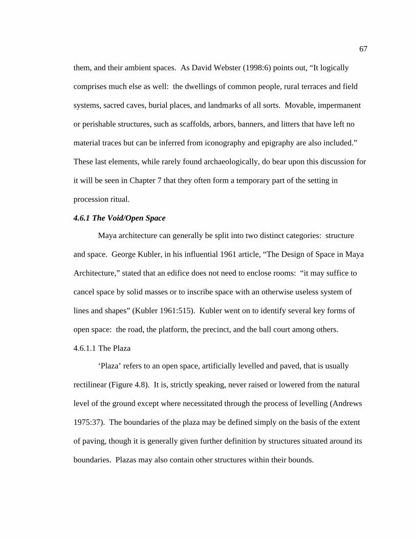
67
them, and their ambient spaces. As David Webster (1998:6) points out, “It logically
comprises much else as well: the dwellings of common people, rural terraces and field
systems, sacred caves, burial places, and landmarks of all sorts. Movable, impermanent
or perishable structures, such as scaffolds, arbors, banners, and litters that have left no
material traces but can be inferred from iconography and epigraphy are also included.”
These last elements, while rarely found archaeologically, do bear upon this discussion for
it will be seen in Chapter 7 that they often form a temporary part of the setting in
procession ritual.
4.6.1 The Void/Open Space
Maya architecture can generally be split into two distinct categories: structure
and space. George Kubler, in his influential 1961 article, “The Design of Space in Maya
Architecture,” stated that an edifice does not need to enclose rooms: “it may suffice to
cancel space by solid masses or to inscribe space with an otherwise useless system of
lines and shapes” (Kubler 1961:515). Kubler went on to identify several key forms of
open space: the road, the platform, the precinct, and the ball court among others.
4.6.1.1 The Plaza
‘Plaza’ refers to an open space, artificially levelled and paved, that is usually
rectilinear (Figure 4.8). It is, strictly speaking, never raised or lowered from the natural
level of the ground except where necessitated through the process of levelling (Andrews
1975:37). The boundaries of the plaza may be defined simply on the basis of the extent
of paving, though it is generally given further definition by structures situated around its
boundaries. Plazas may also contain other structures within their bounds.

68
Figure 4.8: Illustration of a typical plaza plan (lower inset) and plazas at Naachtun
(yellow).

69
Andrews (1975:37) describes plazas as public spaces that, above all, must have
served as a focus of community life. This ‘community life’ could conceivably have taken
any number of forms, incorporating both ritual activity (religious, political, etc.) and a
number of secular activities (plazas may have been used in water management, as market
places, etc.). A plaza, therefore, may be seen to represent all of these things. But do all
plazas represent all of these elements of society and at all times? I would suggest that
plazas are always, to some degree, a product of the structures that they are associated
with. This intuitive statement was shown by Norman Hammond (1972:87) to apply at
Lubaantún, and I suggest that it probably applies in most plaza contexts.
4.6.1.2 The Courtyard
Like a plaza, the courtyard (Figure 4.9) is a space artificially levelled and paved,
though usually small and rectilinear, and often represents a central feature tying together
palace-type architecture. However, unlike the plaza, the courtyard is defined solely by
the structures that surround it (Andrews 1975:38). In this way, the courtyard cannot
properly be thought of as distinct from these defining structures.
4.6.1.3 The Terrace
A terrace (Figure 4.10) is a space very similar to a plaza. It is artificially levelled
and paved, rectilinear, and often bounded by other forms of architecture. The primary
difference is that this space has been built up artificially above the natural ground level.
Edges unbounded by other structures are marked by the intersection of the sloping sides
with the upper level of the terrace (Andrews 1975:38). In some cases, as with the plaza,
other structures may occupy the level space of the terrace top.

70
Figure 4.9: Illustration of a typical courtyard plan (left inset) and courtyards at
Naachtun (yellow).

71
Figure 4.10: Map of Naachtun illustrating locations of terraces (yellow).

72
4.6.1.4 The Platform
Andrews defines the platform as an “open space which is represented by the
upper level of a masonry mass in the form of a stepped and truncated pyramid” (Andrews
1975:38). The specific form and size that a platform may take is more variable than this
suggests (Figure 4.11). It may be a solitary pyramidal platform supporting a single
Figure 4.11: Some variation in platform shape (Redrawn from Andrews 1975:40-
41).
temple structure (Naachtun Structure XXXVIII) or it may be designed to support other
smaller platforms or multiple temple structures (Naachtun Structure I, V, or XXII)
(Figure 4.12). The upper level of the platform may hold another structure such as a
temple, or may be utilized as an open space. The platform may be thought of as a series
of stacked terraces that decrease in area as they are placed one atop the other. A point of
departure between the terrace and the platform is that the mass of a platform is normally
visualized as built up entirely by human labour, while the terrace is conceived of as a
manipulation of extant topographic features such as in the levelling of a hillock or slope.

73
Figure 4.12: Map of Naachtun illustrating locations of platforms.

74
4.6.1.5 The Causeway/Sacbe
The causeway is a graded and paved linear space in the form of a roadway or
platform that is raised above the natural ground level and often extends over wet or
boggy areas. Sometimes the edges of the causeway may be defined by a low parapet,
while the center may support a stone divider. At Naachtun, an as-of-yet unsurveyed
causeway connects Groups C and A (Figure 1.2).
Andrews (1975:38) points out that, “Since the Maya had no wheeled vehicles or
domesticated animals, these spaces must have functioned as processional ways rather
than roads, permitting large numbers of people to proceed in mass from one sector of the
city to another.” He substantiates this statement with the observation that causeways
usually terminate at either end in important plazas associated with important buildings. I
will, not surprisingly, return to this idea later in the discussion.
4.6.1.6 The Ballcourt
The ballcourt is yet another example of the open space in Maya architecture. In
general, the ballcourt is a levelled and paved space that has the plan shape of a capital ‘I,’
though Andrews (1975:39) notes that the open spaces at the bottom and top of the ‘I’ are
not a requirement. This construction is usually found associated with major plazas, and is
generally of the same elevation as the rest of the plaza. The playing alley, represented by
the upright portion of the ‘I,’ is typically bound on either side by a low wall and sloping
bench, and then another, higher wall. The ballcourt will be discussed further in the
following section on Maya structures.

75
4.6.2 Structures
4.6.2.1 The Temple
The simplest definition of a temple is given by Andrews (1975:39) as, “a small
building used for ritual or ceremonial purposes.” Temples typically consist of a relatively
small superstructure of one or a few rooms – either devoid of decoration or else
elaborately treated and including interior shrines – constructed atop a high and relatively
inaccessible pyramidal base (Inomata and Triadan 2003:155). One of the most dramatic
examples of this type of structure has to be Temple I at Tikal, Guatemala, combining the
qualities of an exceedingly small temple atop a pyramid platform that dwarfs much of the
surrounding architecture of the site (Figure 4.13). A number of intact masonry walls
Figure 4.13: Some variation in temple form (Redrawn from Andrews 1975:40-41).
have been found atop platform structures at Naachtun indicating the presence of temple
structures (Figure 4.14). It is likely that additional platforms supported poorly preserved
masonry temples or temples made of perishable materials. These are not indicated on
Figure 4.14.

76
Figure 4.14: Map of Naachtun illustrating locations of temple structures.

77
4.6.2.2 The Palace
The term ‘palace’ is probably the most problematic of the lot. The least loaded
use of the term generally refers to “a large and long structure with multiple rooms or long
galleries, usually built on relatively low platforms,” otherwise known generically as
‘range structures’ (Inomata and Triadan 2003:155). These are typically vaulted masonry
structures, (though structures made of perishable materials were also common) existing
on their own, or as architectural groups that are composed of several such multi-roomed
structures surrounding small plazas or courts (Kowalski 2003:204) such as the palace
groups of Naachtun, Group B (Figure 4.15). The ‘palace’ is most often identified
archaeologically by the long, low platform on which it rests.
Some palace-type buildings were likely elite residences. It must be made clear
however that not all palace-type buildings were used exclusively as residences. Kowalski
suggests that, “The large scale and spatial complexity of these buildings, their associated
architectural sculpture and mural paintings, as well as the remaining furnishings within,
including niches, benches, thrones, and cordholders for the tying of fabrics and mattings,
suggest that many Maya palaces were multiuse structures that simultaneously served as
elite residences, secular governmental centers, and settings for dramatic rituals”
(Kowalski 2003:204; see also Schele and Miller 1986:133-145).
4.6.2.3 The Ballcourt
I have already discussed the ballcourt above as a type of open space. However, it
must also be considered as a specific type of structural architecture. Generally this
consists of two, long, parallel structures with sloping walls that line the ballcourt.
However, there is a great deal of variation possible in the form and size of the ballcourt

78
Figure 4.15: Map of Naachtun illustrating locations of palace structures.

79
from the exceptionally large and elaborate example at Chichén Itzá to the small and
simple ballcourt of Uaxactun (Figure 4.16) and, indeed of Naachtun (Structures XIII and
XIV, Figure 4.17). These structures are often topped with small palace-type buildings.
Figure 4.16: Some variation in ballcourt plan (Redrawn from Andrews 1975:48-
49).
4.6.2.4 The Stela
One further item that should be included in this list, though strictly speaking it is
not a type of architecture, is the stela. Stelae are large monoliths ranging from two to six
meters tall and sometimes as much as, or over, one meter square at the base, and
commonly (though not always) covered in relief sculpture and text on one, two, three, or
all sides (Andrews 1975:51) (Figure 4.18). They are practically ubiquitous at any Maya

80
Figure 4.17: Map of Naachtun illustrating location of ballcourt.

81
site of any importance. On the map of Naachtun, stelae are indicated by small,
numbered, black rectangles (see Figure 1.2).
Figure 4.18: Photograph of Naachtun Stela A5 taken facing structure XXVII
(photograph taken by S. Morton 2004).
The majority of stelae are placed before the stairways of temple or palace
structures, though they may appear in other locations as well, marking the entrance to a
plaza, or along a causeway. As the form and setting of stelae can vary, so too can the
subject matter of the standing stone. Stelae may depict scenes of ritual or myth, family
genealogies, accounts of victory and defeat; they may dedicate the construction of a
building, or may even be left blank.
4.7 Drawing the Rectilinear Map
Armed with the above information it is possible to infer basic structure types
(most structural details are simple guesses) from fallen mounds albeit with the caveat that

82
excavation may change this interpretation. A long low mound suggests a long low
structure such as the substructure of a palace (Figure 4.19). A ‘haystack’ mound suggests
Figure 4.19: (A) Contour lines indicating the form of several interconnected
mounds (Structure XL). (B) A rectilinear drawing of the same structure indicating
general features of a palace-type structure including a stairway.
a pyramidal platform (Figure 4.20). However, the shape of a mound is not the only clue
available for interpreting structure type. Observations made in the field can add to this
interpretation. The corners of a building may still be visible (this is often visible on the
topographic maps as well). Collapsed stairways are often easy to identify. Some
structures such as Structure V (Figure 4.21) still have standing walls or vaulted roofs.
And at Naachtun, saqueos can provide a look at the inside of structures (the sloping walls
of the ballcourt were identified this way) (see Figure 4.17). After the identities of these
structures had been interpreted, rectilinear representations were overlaid on the
topographic survey map in order to produce a representation of Naachtun as it appeared
in the Late Classic period.

83
Figure 4.20: (A) Contour lines indicating the form of a substructure platform with
several pyramidal mounds atop (Structure I). (B) A rectilinear drawing of the same
structure indicating general features of a multi-temple structure.
Figure 4.21: Structure V showing standing architecture (Photo by M. Peuramaki-
Brown 2005).
4.8 Preparing an Axial Map
So far this chapter has dealt with the history and methods of survey at Naachtun
and the methods of interpreting Classic period architectural features at this site from the

84
topographic data gathered through the survey. This section is concerned with the
methods of processing the rectilinear map of Naachtun discussed above into a form to
which axial analysis may be applied. In Chapter 5 the resultant axial line map is
interpreted as a secondary line of evidence when suggesting a formal path, likely
appropriate for procession ritual, through the site core of Naachtun.
In Chapter 3 I outlined four assumptions of axial line analysis. When producing a
map for axial analysis the first three assumptions come into play as rules: 1) there are
physical barriers to movement. 2) there are barriers to vision, and hence movement. 3)
there are boundaries to space, based on cultural norms that, while they may not be
physically or visually inhibiting, are effective barriers to movement. Following these
rules, under ideal circumstances, in a well defined core with ample surrounding
settlement data, with all of its architecture completely intact, and with a full enough
knowledge of the cultural norms of those utilizing this space (a tall order even when
working with modern western cities), axial analysis has proven to be an extremely useful
tool. As each of these circumstances deviate from the ideal however, uncertainty is
brought into the analysis.
This is the situation that I face when attempting to apply axial line analysis at
Naachtun. While the site core is relatively well-surveyed, it is recognized that the
rectilinear Morton map is an interpretation based on the fallen mounds of current-day
Naachtun and as such the precise dimensions of any space on the Morton map are, at
best, a close approximation. In addition, the settlement data at Naachtun is not available
to nest the site core within a wider network of space, resulting in a problem known as an
‘edge effect’ that will be discussed below. Further, it is almost certain that not all

85
architectural features of Late Classic Naachtun are today completely intact. Aside from
relatively permanent structures made from perishable materials that have long since
decayed without a trace, it is likely that procession ritual made use of temporary
structures that are likewise absent in the archaeological record (Chapter 7). Finally,
while the Classic Maya are among the best-understood pre-contact peoples in the New
World such is the nature of archaeology that there is and always will be a good many
uncertainties about their world and how they lived in it. It is for these reasons that in this
thesis I use axial analysis solely as a supplementary line of evidence, and I stress that the
results of axial line analysis should always be taken with a measure of caution.
In order to produce a map for axial line analysis boundaries are drawn in
accordance with the three rules listed above (Figure 4.22). The first (there are physical
barriers to movement) and second rules (there are barriers to vision, and hence to
movement) are easy-enough to apply using the rectilinear map of Naachtun, and
generally result in boundaries being drawn in the same locations. Wherever movement is
impeded by the walls of solid masonry structures (such as Structure V or XX), long low
mounds assumed to have held perishable structures in the Classic period (such as the
structures to the southwest of Group A’s walled compound) or rapid changes in
topography (such as the edge of the limestone shelf upon which sits Group C) a barrier
was indicated on the map by a line. Application of rule three (there are social barriers to
movement) is a little more complex and is based on the idea that not all members of
Maya society enjoyed the same freedoms and privileges (Chapter 3). It is assumed that
procession ritual was openly participated in or observed by all members of society. And

86
so, the spatial boundaries of the lowest common denominator, the non-elite class, are
applied. For this reason, stairways, platform tops, the interior spaces of temple and
Figure 4.22: (A) Map of Naachtun prepared for axial line analysis. (B) The
rectilinear map from which (A) was generated.
palace structures and restricted courtyards are blocked from the analysis by boundary
lines.
The map is not yet ready for an axial line analysis however. In figure 4.22 it can
be seen that Naachtun’s core area has been surrounded by a boundary line not explainable
by the three rules above. Because I only have Naachtun’s core architecture to work with

87
(I am missing settlement data that would have served to contain the analysis), if I applied
an axial line analysis without this boundary the ‘edge effect’ mentioned above would
skew my results signifying that the most integrated paths suggested by this architecture
do not actually pass through it but around its edges. To reduce this effect and force the
analysis to look for the most integrated paths that actually pass through spaces of the site
core I have included an arbitrary border close to the edges of the surveyed area.
The resultant map is then imported into Depthmap and an axial line graph is
generated (Figure 4.23) where lines are colour coded according to their level of
integration (red, orange, yellow, green, blue, indigo, and violet), red lines being the most
integrated and violet the least (while Depthmap generates axial lines slightly differently
than one would by hand, the results are similar). The significance of these lines in
determining a likely setting for procession ritual will be addressed in Chapters 5 and 7.
Figure 4.23: Axial line map of Naachtun’s core.

88
4.9 Discussion
In procession ritual it will be suggested archaeologically and will be shown
ethnographically (Chapter 7) that different types of procession ritual have different
requirements both in terms of the physical and the symbolic environments. It has further
been suggested here and in Chapter 3 that the symbolic environment is overlaid on the
physical environment. As such, this chapter was concerned with methods of identifying
the physical environment of Naachtun’s core architecture. I began with a discussion of
previous cartographic work at the site and the rationale and methods behind my survey of
the site core from 2004 and 2005. The interpretive exercise of identifying specific
architectural types from topographically surveyed mounds was couched in a general
discussion of Maya monumental architecture. Finally, the methods behind preparing the
Naachtun map for an axial line analysis were covered in anticipation of its use in Chapter
5 as a secondary line of evidence for suggesting a formal route through Naachtun’s core
architecture and a likely route for procession ritual.

89
Chapter Five: The Physical and Symbolic Architecture of Naachtun and the
Identification of a Formal Route
5.1 Introduction
In the first section of this thesis I have been concerned with the study of
Naachtun’s monumental site core. I introduced the general geographical, cosmological,
social and political environments of Naachtun that may have affected the site plan and
may be drawn upon to provide meaning to that plan. I have introduced the theory of
space syntax and a type of spatial analysis known as ‘axial line analysis,’ and I have
outlined the methods of mapping and interpreting architectural features of Naachtun’s
core as well as the methods used to apply axial line analysis to this plan.
In this chapter I bring all of this work together to describe the physical and
symbolic plan of Late Classic Naachtun. Further, I suggest that through this environment
weaves a formal path that I suggest was both intentionally incorporated and maintained
through the will of the ruling elite of Naachtun. Later, in Section Two (Chapter 8) of this
thesis, I propose that this path represents an appropriate setting for procession ritual.
5.2 The Results of the Survey
The physical environment of Naachtun is the foundation upon which the symbolic
environment is built. Therefore, the first step in a discussion of Naachtun’s core
architecture is to present the results of my survey at the site. While survey of Naachtun’s
site core resulted in the incorporation of only one additional structure in this area, the
changes made to the Naachtun map go well beyond this. The full extent of these changes
can be seen when the Morton and O’Neill maps are placed side by side (Figure 5.1).

90
Aside from the inclusion of an otherwise unmarked structure (La Perdida) the
differences in the maps are primarily associated with structural details and the
orientations and locations of structures. A number of these differences are significant in
the discussion of Naachtun’s site plan. First, a number of the structural details will
ultimately prove to be important. The stairway located on the east side of Structure XX
brings into focus the odd placement of stelae to the south of the structure (Figure 5.1 n.
4). In this chapter this is used as evidence for a formal route or path through Naachtun’s
site core. In addition, the identification of the ballcourt (Structures XIII and XIV) (Figure
5.1 n. 3) is important in the discussion of Naachtun’s cosmological setting.
Second, details of structure orientation and location will prove important. The
reorientation of structures and spaces in Group B is the most significant example (Figure
5.1 n. 6). It can be seen that the space of the Avenida on the Morton map is more open
than on O’Neill’s original. This change is important in the axial analysis discussed in
Chapters 3 and 4 and again later in this chapter: As with any study, the quality of
analysis is fundamentally related to the accuracy of the data employed and hence the
formal spatial analysis represented by axial line analysis should properly be applied to an
accurate representation of space. In this way the Naachtun represented by the Morton
map is an improvement over the O’Neill original and it is that representation of space
used in this thesis.

91
Figure 5.1: An illustration of the differences between the O’Neill and Morton maps
(O’Neill map redrawn by E. Reese Baloutine from Ruppert and Denison 1943).

92
5.3 The Site Plan of Naachtun
What is immediately recognizable when one looks at a plan of Naachtun’s core
architecture is its extreme east-west directionality (Figure 5.2). A basic description of its
physical plan would include the observation that the site core rests primarily upon two
elevated limestone shelves separated by a low area, which, connects two bajos to the
north and the south of the site centre. One would also immediately recognize the series
of interconnected plazas that unite the site plan in Groups A and B. In addition, on the
ground a causeway would be observed connecting Groups C and A. This description
would also include the presence of structure types that run the gamut of general
architectural types already outlined in Chapter 4. There is variation in structure style and
spatial organization throughout the site, and there are a few ‘odd’ architectural features in
the site plan including the walled compound in Group A, the elongated ascending plaza
of the Avenida, and La Perdida sitting alone in the low area to the west of Group A,
bypassed by the causeway and facing the back of the imposing Structure XX.
How is this plan to be explained? Following the examples in Chapter 3 it can be
seen that most approaches to the study of site plans take a static approach. By ‘static,’ I
mean to emphasize that the environment is treated as a series of set pieces. While
individual structures may serve as an interactive setting for activities both secular and
spiritual, the site plan as a whole is rarely woven together by the movement of actors as a
‘dynamic’ meaning laden and living space, the approach highlighted in this thesis. There
is value in both approaches. In this chapter I begin by briefly discussing the site plan of
Naachtun as a static environment in the Late Classic period.

93
Figure 5.2: Rectilinear map of Naachtun’s core architecture.

94
After a discussion of Naachtun’s chronology and history I discuss this same site
plan in a diachronic light. Finally, following a more dynamic approach to the study of
space I formally identify and describe a major path through Naachtun’s core architecture
and discuss how the movement of people along this path can broaden the symbolic
meaning of Naachtun’s plan. This last approach lies at the heart of the discussion to
follow in Section Two.
5.3.1 A Synchronic Approach to a Static Environment
If we look at the final, Late Classic form of Naachtun (Figure 5.2) we can suggest
that it developed following a number of the site planning considerations discussed in
Chapter 3. The most basic of these considerations is topography. In Chapter 2 I
discussed the geography of the Naachtun area. Topographically this is characterized by
limestone hills and ridges separated by low, perennially boggy areas known as bajos. As
noted above, the site core of Naachtun was built atop two limestone shelves where they
were likely meant to take advantage of the relatively flat topography and dry ground
conditions that these shelves provided. These shelves were connected to one another via
a sacbe, or causeway, a raised path that likely afforded dry footing in the lower areas that
may have otherwise been wet during the height of the rainy season. Even the linearity of
Naachtun’s site plan is at least partially explainable with reference to topographic
considerations. Naachtun is flanked to the north and south by bajos, which, were
connected to one another via a series of small arroyos and the low area between Groups
C and A as previously discussed. These bajos may have restricted expansion of the site
core to the north and south though, as evidenced by the artificial expansion of the North

95
Plaza (indicated on the map by a masonry slope), these obstacles were not entirely
impossible to overcome.
The implementation of a number of functional considerations by the site planners
of Late Classic Naachtun may also be discussed. Roberta Parry is currently investigating
the relationships between architecture and water management at Naachtun (MA thesis in
progress). While I will not get into the details of her findings, topographic survey of a
number of Late Classic plazas (the East Plaza and the Avenida) that I completed during
the 2005 season of the Proyecto Naachtun indicate grading consistent with that reported
by Scarborough (Scarborough 1994; Scarborough et al. 1992, 1994, 1995; Scarborough
and Gallopin 1991). It is also possible that the arroyo extending from the south side of
the Group A reservoir into the low area between Groups C and A was a part of this
system. Further, the causeway between Groups C and A (Figure 5.2) may have directed
water away from La Perdida, the only other structure in that area of the site.
As previously noted, functional considerations may also include defensive
structures or plans like those found at Cerros or Mayapan. At Naachtun a walled
compound has been found in the southwest of Group A. Investigations by Ernesto
Arredondo (PhD dissertation in progress) have shown that structures within these walls
covered a range of monumental architecture types and could potentially have served as a
closed system for religious and political activity when the site was threatened. As at
Mayapan the architecture in this portion of the site was exceptionally dense and of
unusual proportion.
Cosmological considerations may likewise have been important. As discussed in
Chapter 3, various types of architecture may have been imbued with specific

96
cosmographic connotations. Each of the many temple mounds and pyramidal platforms
of Naachtun (Chapter 4) may have represented water-mountains, nodal points between
the three levels of the Classic Maya cosmic world. The Ballcourt (Chapter 4) may have
held similar meaning. Reservoirs and plazas (Chapter 4) may have acted as portals and
architectural representations of the Underworld. This cosmologically charged
architecture may have served as the stage in any number of ritual or religious activities at
the site. Not surprisingly, this is a topic that will be returned to in Chapter 8.
Finally, from the Late Classic period site plan of Naachtun we can look for
evidence of socio-political considerations. Here, in the monumental architecture of the
site core the basic division in Maya society between the elite and the non-elite is writ
large; this architecture represents almost one thousand years of elite power, control and
the ability to draw resources. Further, whether one accepts the precise details of the
theatre state model or not, it is widely accepted that religion and ritual power were
important elements in the elite power base. Therefore, the architecture of the site core,
tied as it was into the Maya cosmological web, was intended both as a representation and
a setting for the demonstration of the elite right to rule.
5.3.2 A Diachronic Approach to a Static Environment
We can further look at the site plan of Naachtun in a diachronic light. By looking
at how Naachtun developed over time and under what historic conditions, it is possible to
suggest the reasons for specific features of this development and to look for meaning that
may have been drawn from its plan. A word of caution is introduced at this point,
however, as our knowledge of Naachtun’s chronology is still very basic and its place in
history is only now beginning to be studied.

97
5.3.2.1 Site Chronology
Based largely on ceramic evidence (though incorporating aspects of architectural
style as well), a preliminary chronology for Naachtun has been produced by Debra
Walker and Sylvia Alvarado (Table 5.1)1. It appears that the site was occupied from the
Late Preclassic, 7.15.0.0.0 (58 BCE), up until the Early Postclassic, 10.3.0.0.0 (889 CE).
Naachtun experienced sporadic growth throughout this period, eventually succumbing to
the same ‘collapse’ felt across the Maya area.
Test pitting, excavation, and surface collection have provided us with
chronological information for specific structures at Naachtun. Naachtun, unlike many
centres of the Classic period, seemed to grow laterally over time with less emphasis
placed on building new structures over older versions than is commonly found. The
earliest evidence of human activity at Naachtun, dating to around 7.15.0.0.0 (Naachtun
1), comes from ceramics found at the bottom of the reservoir. Structures I and V appear
to have been constructed in the following phase (Naachtun 2), dating between
approximately 8.0.0.0.0 and 8.6.0.0.0 (41-159 CE). The order of construction at
Naachtun is a little unclear, but it appears that most of Group C was constructed by the
end of Naachtun 3A (8.10.0.0.0, approximately 238 CE), though modifications continued
to be made to the group over time. By the end of the late facet of this phase (Naachtun
3B, 8.13.0.0.0, approximately 292 CE), it is likely that La Perdida and most of the
buildings in the North Plaza of Group A were completed. The next phase of Naachtun is
1 Following convention, dates are typically written in the Maya long count with Julian dates following in
parentheses. Structures are given approximate dates based on associated ceramics. While dates written on
monuments, including stelae, provide chronological and historical data, they are not used to date structures.

98
again split into an early and a late facet. By the end of the late facet (Naachtun 4B,
9.6.0.0.0, 554 CE) most of the West Plaza, probably including structures XIII and XIV
Table 5.1: Naachtun chronology (Walker and Alvarado 2005).
Long Julian Period Naachtun Textual Evidence
Count Date
7.15.0.0.0 58 Late Preclassic Naachtun
BCE 1
8.0.0.0.0 41 Late Facet Naachtun
CE Late Preclassic 2
8.6.0.0.0 159 Early Facet Naachtun
CE Protoclassic
Horizon 3A
8.10.0.0.0 238 Late Facet Naachtun
CE Protoclassic
Horizon 3B
(Early Classic 1)
8.13.0.0.0 292 Early Classic 2 Naachtun
CE 4A
8.17.1.4.2 378 Early Classic 3 Naachtun Looted jade earflares
Masul Lord vassal to Spearthrower Owl
CE 4B Balanza Group jar Masul Lord mentioned
9.2.11.7.8 Tikal attacks Masul Lord
9.2.11.7.15 Masul King dies
9.3.10.0.0 Naachtun St. 23
9.5.0.0.0 Naachtun St. 3
9.6.0.0.0 554 Late Classic 1 Naachtun 9.9.10.0.0 Naachtun St. 1
CE 5 9.10.0.0.0 Naachtun St. 2
9.11.0.0.0 652 Late Classic 2 Naachtun 9.11.0.0.0 Naachtun St. 18
CE 6A 9.13.11.6.7 Masul Lady dies at Topoxte
9.13.19.16.6 her bones moved to Tikal
9.14.?.13.? Naachtun St. 15
9.15.0.0.0 Naachtun St. 9
9.16.0.0.0 Naachtun St. 8
9.16.10.0.0 Naachtun St. 10
9.17.0.0.0 Naachtun St. 7
9.18.0.0.0 Naachtun St. 6
9.18.0.0.0 791 Late Classic 3 Naachtun
CE 6B
10.3.0.0.0 889 Early Postclassic
CE

99
(together making up the ballcourt), XV, XVI, XVII, and the walled compound in the
south-west of Group A were constructed. In Naachtun 5 (9.6.0.0.0 - 9.11.0.0.0, 554-652
CE), the South and East Plaza’s of Group A were constructed. The next phase (Naachtun
6A and 6B) represents the last period of construction at Naachtun. During this phase
(9.11.0.0.0 – 10.3.0.0.0, 652-889 CE) structures XXXVIII, XXXIX, and XL were
constructed, as presumably were the rest of the Group B structures (Walker and Alvarado
2005).
Unfortunately, our knowledge of the site is limited and while Naachtun was
undoubtedly shaped by almost 1000 years of change and development, at this moment,
site chronology and excavation in general are sufficiently progressed to the point where I
can discuss only the Late Classic (6B) phase of Naachtun’s core site plan with any
confidence. Nonetheless, I here make a number of tentative suggestions that link the
formation processes of Naachtun to its chronology as it is currently understood.
5.3.2.2 The History of Naachtun
The formation processes of any site are historically particular. It has been
suggested that the more stable a site’s socio-political history is, the more stable we can
expect its formation processes to be (Sharer 1985). As has been made clear above
(Chapter 3), socio-political organization throughout the Classic period was anything but
stable. Naachtun has its own history tied into the web of Mesoamerica.
An important source of evidence relating Naachtun to its neighbouring sites is
textual. But Naachtun (meaning ‘distant stone’) is not the Classic Maya name for the
site. We don’t know with certainty what Naachtun’s Classic name was—it has not been
found on any of the monuments at the site, most of which are badly eroded—but there is

100
a certain amount of circumstantial evidence that suggests Naachtun may have been called
either Maasal or Masul (Martin and Grube 2000:21, 30). Regardless of its spelling it
seems clear that Masul was a relatively prominent city lying somewhere in the contested
territory between Calakmul and Tikal (the principle antagonists of the Masul story)
(Figure 5.3). Naachtun is the only unnamed site of any significant size known to lie in
this area.
It is well for us if Naachtun is Classical Masul – and indeed I am of the opinion
for the purposes of this thesis that it is – for we have epigraphic evidence from Tikal and
elsewhere that sheds light on the relationships between Masul, Tikal, Calakmul, and
Teotihuacan at various times in their shared history.
Through the first half of the Early Classic period Masul is practically invisible
epigraphically. Datable material from Naachtun suggests that the site was occupied to an
unknown degree by at least the Late Preclassic period, 7.15.0.0.0 (58 B.C.E.). Tikal was
a small city by this period having enjoyed a prosperous Middle Preclassic fluorescence
(Martin and Grube 2000:26). Both sites are survivors of the Preclassic collapse (around
the 1st century C.E.) that claimed many larger centres including nearby El Mirador
(Martin and Grube 2000:8), and both seem to have prospered throughout the following
Classic period.
By the time of the Entrada, 8.17.1.4.2 (378 C.E.), at which time the Central
lowlands may have been invaded by a people hailing from Teotihuacan and Central
Mexico, Tikal was a large settlement. At this time, Naachtun’s site core consisted only of
Group C and the North Plaza of Group A. At some point in Naachtun’s history the North
Plaza was surrounded by a large earthen bank and wooden palisade. While, at this point,

101
Figure 5.3: Map of Maya area showing major sites (redrawn from Sharer 1994).
there are no dates securely attached to this feature, it is reasonable to assume that it was
constructed during a period when Naachtun’s social, political, and religious activities

102
were focused on this part of the site. It is possible that Naachtun was already feeling
pressure from external sources at this time
It is clear that the events of the Entrada were felt far and wide across the Central
lowlands. Textual evidence suggests that in 8.17.1.4.2 (378 C.E.) the ruling lineage of
Tikal was replaced by the invaders. At Uaxactun, Stela 5 celebrates the same arrival
(Entrada) event seen at Tikal (Martin and Grube 2000:30). And as at Tikal, there is
evidence that rulers with Central Mexican loyalties are installed at Bejucal in 381 C.E.
and Río Azul in 393 C.E. (Martin and Grube 2000:30; see also Adams 1998). In this
setting Masul is found mentioned for the first time on a looted jade ear ornament,
presumably from the site of Río Azul, that states that its ruler is the yajaw or ‘vassal’ of
Spearthrower Owl (Martin and Grube 2000:30), possibly the ruler of Teotihuacan. If the
adoption of an emblem glyph marks the achievement of statehood as Mathews suggests
(1991), then Naachtun may have been born into a state of subservience.
At Tikal, the first mention of Maasal, or Masul, is found on Stela 10, dating to
486 C.E., more than a century after the Entrada event. It seems that at this time, Tikal’s
then ruler, Kaloomte’ B’alam was involved in the ‘axing’ of the city and the capture of a
prisoner (Martin and Grube 2000:39). It is unclear who this ‘prisoner’ was, but it is
likely that it was either the ruler of Masul, or another elite individual. This event marked
the beginning of increased aggression by Tikal and subsequent retaliation throughout the
Central lowlands that ultimately ended in its defeat in the middle sixth century C.E.,
presumably at the hands of Calakmul (Martin and Grube 2000:39).
After the ‘hiatus’ of Tikal, a 130-year period during which growth at this major
centre stagnated, Tikal experienced a spectacular reversal in its fortunes and a return to

103
its former prominence. The last reference to Masul dates to this period in Tikal’s history.
Tikal Altar 5 relates an exhumation ritual in which the Tikal king is joined by the ruler of
Masul to disinter the bones of an unknown Lady who had died at Topoxte nearly a
decade before (Martin and Grube 2000:46; Walker and Alvarado 2005). This was a
significant event, as it may both indicate a push north by Tikal and hint at the tone of the
relationship between Tikal and Naachtun.
While no later references to Masul are known in the epigraphic record, we do
know something of its end. Though Naachtun was a survivor of the Preclassic decline, in
the sudden collapse of the Maya civilization in the 9th
century C.E, it, like a great many
other dynasties at this time, disappeared and population levels across the Maya area
plummeted.
5.3.2.3 Naachtun’s Site Plan Revisited
Naachtun’s construction history has already been discussed above. Here it is my
goal to tie specific architectural features to the socio-political history of Naachtun such as
we know it. Naachtun’s particular political history may aid in the effort to explain a
number of the ‘unusual’ features of its site plan. For instance, the now lonely and
isolated La Perdida was, at the time of its construction, paired with what is now a
substructure (20-Sub 3) of Structure XX. Investigation in the saqueos of Structure XX
by Baudilio Salazar (2005:113) in 2004 have revealed that 20-Sub 3 was similar in size to
La Perdida and, more significantly, was constructed alone atop its limestone shelf with a
stairway facing La Perdida to the west. With the construction of the North Plaza
sometime before 292 C.E. the stairway to Structure XX (20-Sub 2) was moved to the east
side and La Perdida settled into the lonely position it has today. Even the sacbe between

104
Groups C and A passes by La Perdida without deviation or acknowledgment. This may
suggest that it was constructed at some point after 292 C.E after the focus of the site
center had shifted away from La Perdida.
At some point in time between 292 C.E. and 554 C.E. (a broad expanse in time to
be sure) Naachtun experienced a general increase in the pace of expansion that included
the construction of the walled compound in Group A (an undated palisade, mentioned
above, may also have been built at this time). While it is not certain what events
specifically led to the construction of this compound the timing of its construction falls
roughly in accordance with the Entrada event of 378 C.E. and the tumultuous political
atmosphere of the Central lowlands in the centuries following, that culminated with the
fall of Tikal in the 6th
century C.E. The expansion of Naachtun’s core, the symbol of its
power structure, and the construction of a defensive compound coincide well with an
insecure political system that was feeling pressure from external sources.
A further insight into the socio-political world of Naachtun may be gained by
looking at the last phases of its construction (Naachtun 6A, 6B: 652-889 C.E.). At this
time Naachtun again experienced rapid growth within the site core that may have
represented both prosperity and instability as the ruling elite exercised their power to
control labour and resources. Textual evidence from this period (Tikal Altar 5, the re-
internment of a noble woman) suggests an amiable relationship between Masul and Tikal.
However, a number of the structures (XXXVIII, XXXIX, and XL) constructed in Group
B at this time have been suggested to show heavy Central Yucatecan influence (Seibert
2006b). Following Ashmore’s example at Quirigua (Ashmore 1986) it is possible that
Naachtun was asserting an affiliation with Central Yucatán. Alternatively, Naachtun may

105
have been asserting itself as a more powerful state, participating as an equal in ritual with
the Tikal lord and architecturally stating its distinctiveness from this same centre.
5.3.3 A Synchronic Approach to a Dynamic Environment
My final task in this section is to return to the Late Classic site plan of Naachtun.
Above, this plan was discussed as a product and symbol of Classic period cosmological,
social, and political systems. I also discussed how topographic and functional
considerations were tied into the plan of Naachtun. However, this approach to the city,
while informative, misses much of the point of archaeology in that it largely fails to take
into account people. Here, the fundamental purpose is to formally identify and describe
the characteristics of a formal route or path through the core architecture of Naachtun.
By populating this path new meaning is brought to the site plan of Naachtun. In Chapter
8 of this thesis, this dynamic view of space will take its place beside those above in the
discussion of Late Classic procession ritual at Naachtun.
No formal spatial study is required to see that a person can travel freely through
Groups A and B via a series of interconnected plazas (the Avenida de las Estelas, and the
East, South, and West Plazas), nor is a formal study required to suggest that the most
direct path between Groups C and A follows the causeway. Specifically, this path
connects Structure XXXVIII on the far eastern side of the core with the most westerly
structure in the site core, Structure I (Figure 5.4). Further, it is possible to identify a
number of characteristics of this path that have an influence on the cosmological
symbolism of Naachtun and that are of importance for the discussion of procession ritual
in Section Two.

106
Figure 5.4: Map of Naachtun indicating the location of a formal route (red line).
5.3.3.1 Maintenance of a Formal Route
Despite nearly a millennium of growth and change at Naachtun a path was
constructed and maintained through the heart of the site core. It can be suggested that
this path was formally recognized by at least the Late Classic period (when it took the
form identified above). The positions of monuments at Naachtun, specifically stelae and
altars, are somewhat unexpected. In general, stelae and altars are located in places where
one would expect to see a large number of people gathering. Usually this means that they
are located in plazas, marking stairways to temple platforms and other important
structures such as in front of the North Acropolis at Tikal, or in front of Structures 11 and
27 at Copán (see Satterthwaite 1958).
Following this model, at Naachtun we would expect to find such monuments in
front of Structure XXIII or flanking the stairway of Structure XX, but we don’t. While
there are some examples at Naachtun of stelae and altars being positioned in front of
structures (ex. Stelae C5, C6, C7, A6, 18 and 19), the majority of monuments are found

107
on the backsides of structures (ex. Stelae 10, A7, A8, 7, 8 and 9) or even in open spaces
(ex. Stelae 20, 13 and 14) (see Figure 5.2 for the locations of stelae). This pattern, while
unusual, is by no means completely unheard of. Satterthwaite (1958:73) points out that
Tikal Stela 25 seems not to have been associated with a structure and that Caracol Stela 3
as well as others at this site were found well away from structures.
According to Satterthwaite there are a number of reasons that we may encounter
‘unusually’ placed stelae (1958). Generally, these fall into three categories: 1) Stelae
may be relocated for a new or modified ceremonial purpose (Satterthwaite 1958:58).
This includes the simple re-erection of a stela in the ‘normal’ manner at a new location
such as in the case of Uaxactun Stelae 18 and 19, or the ‘caching’ of a monument within
a structure as with Naachtun Stela 26. 2) Relocation may be for some practical purpose
(Satterthwaite 1958:58) such as a monument’s re-use as a building material as with
Naachtun Stela 27, re-used as a step in Structure XI, and Piedras Negras ‘Lintel’ 12, re-
used in a Late Classic temple wall (Satterthwaite 1958:58 n. h). 3) A monument may
have been discarded. These may be found on a midden, scattered on an ancient surface,
or as a complete monument or large fragment abandoned after partial movement toward
an intended new location (this potentially serves as an explanation for Tikal Stela 25 and
Caracol Stela 3) (Satterthwaite 1958:58).
Rather than being a product of the latter two behaviours, at Naachtun it seems that
most of the unusually placed stelae were intentionally set in their current locations by the
Late Classic period (Ruppert and Denison 1943:131-136). Further, it seems indisputable
that the placement of stelae at Naachtun indicates that, during the Late Classic period, the

108
entirety of the proposed formal route was in use, the most recent-dated stela being placed
in Group C.
Finally, if we accept that monuments were meant to be seen, then it can be
suggested that at Naachtun, monuments were generally not positioned to communicate
with people using the main plazas and dominant façades of structures, but instead were
intentionally positioned to communicate with people using the formal route described
above and to encourage such use.
5.3.3.2 An Architectural Magnet for Movement
Axial line analysis, a type of formal spatial analysis described in Chapters 3 and
4, provides us with another way of looking at the formal route. By simply looking at a
plan view of Naachtun as I have done above there is no way of objectively qualifying
spaces or paths and no way of formally comparing one space to another. As discussed in
Chapter 3, the theory and tools of space syntax and specifically, axial line analysis may
help to do just this. Based on the city plan itself, axial line analysis can be used to qualify
the spaces and paths of a plan, to suggest the ease with which a path may be traversed
and, following this, to make suggestions about likely patterns of pedestrian movement.
This in turn is based not only on the characteristics of any particular path in itself, but on
its location relative to other paths in the system as well
Following the rules outlined in Chapter 4 an axial line diagram of Naachtun’s city
core can be generated (Figure 5.5) and from this a path can be interpreted representing
the most likely route a person would take from one end of the site core to the other.
Observing the axial line diagram one will notice that lines, or probable paths of
movement through the site core range in colour from red to violet (in order: red, orange,

109
Figure 5.5: Axial line diagram of Naachtun.
yellow, green, blue, indigo, violet), with red representing the most integrated or strongest
paths of movement and violet representing the least integrated or weakest paths of
movement.
The route identified intuitively by looking at the site plan is here picked out
among the rest. Further, through axial line analysis it can be suggested that the path most
attractive to modern eyes was likely attractive to the feet of the Classic Maya. Beginning
in Group C (though the route could be discussed in the opposite order as the analysis on
its own does not specify any preferred direction of movement), a series of yellow lines in
a sea of blue indicate that the best integrated paths through this area begin at and around
Structure I, the most westerly monumental structure of the site core, then stretch past a
series of other small structures in the group and through a small break in the steep down-
slope to the east that effectively isolates this group from the rest of the site core.
Following this path into Group A, the yellow lines are intersected by a number of
red (very well integrated) lines. Encountering a more attractive route, a person walking

110
would most likely follow this path east (turning from one path to the other at an obtuse
angle). This path leads our person to the north of Group A’s large walled compound and
to the south of Structures XIII and XIV, through the West Plaza and into the East Plaza.
No potential path through the site is more integrated, and hence more attractive to
movement, than the one that our person is currently walking. The red path ends in the
East Plaza. From this point, there are two options: 1) With no better path available our
person could call it quits, or 2) with a desire to reach the other end of the site core our
person could settle for a slightly less integrated path (an orange path). Therefore, opting
to continue, and again changing paths at an obtuse angle, our person moves south through
the East Plaza.
At the southern end of the plaza, our person is confronted with a familiar
problem: They have encountered any number of potential paths intersecting their own,
but none are as strongly integrated as the one on which they are currently traveling. If
they continue on this path our person will leave the site core altogether. Another option
is available however. If our person again chooses a slightly less integrated path (a yellow
one), though one that is still much stronger than the ambient background of blue and
violet paths at this end of the site core, and turns at an obtuse angle, they will be walking
along an elongated plaza, the Avenida de las Estelas, terminating their journey at
Structure XXXVIII, the most easterly monumental structure of the site core. In
unintended support of this interpretation, the trail established to take visitors through the
site makes use of much of this path.

111
5.3.3.3 Continuity of the Path
Maintenance of a formal route suggests that the elite of Naachtun recognized the
power of such a path to integrate the site core. It also seems that the elite were aware of
the weaknesses in this route. Whether moving west-to-east or east-to-west a traveller on
Naachtun’s formal route is eventually faced with a ‘break’ in the path, a location where
the traveller is faced with a number of different potential paths. In the axial line analysis
these are locations where a traveller has to make a move to a less integrated path. At
these points it seems that a number of ‘magnets’ or ‘attractors’ (Chapter 3) were used to
draw people down specific paths.
Beginning in Group C following the path suggested by the axial analysis, each
time a person is obliged to change from one path to another they are moving to a more
strongly integrated path, that is, until our person enters the East Plaza. As noted above, at
this point there are no more-integrated paths available. This is where a previous stream
of evidence, the placement of monuments, may come into play. Confusion in the route to
take at this point is eased by the placement of a number of stelae and altars through the
center of the East Plaza. Placed in a linear arrangement along a less integrated path these
monuments would have encouraged movement through the space (see Figure 5.4).
Application of the same principle of attractors or magnets may be responsible for the
stelae that line the Avenida as a person would again be shifting to a less-integrated path
than the one that they were traveling.
This system of strategically employing ‘attractors’ for movement at Naachtun
worked in both directions. Should a person begin moving along the route from the
eastern end of the site they are drawn along more and more integrated paths until they

112
reach the west end of the West Plaza. At this point the arrow-straight masonry of the
sacbe may have acted as an attractor for movement much as did the monuments when
travelling the route in the other direction.
5.3.3.4 Cosmological Implications of a Formal Route
With the establishment of a formal route through the core of Naachtun,
boundaries were established for the cosmological model represented by the site’s
architecture. With these boundaries in place a broader meaning may be suggested of
Naachtun’s site plan. At the eastern end of the formal route stands Structure XXXVIII, a
pyramidal platform and temple generically representative of a witz or water-mountain. A
similar representation rests at the western end of the formal route in the form of Structure
I. But with the formal route in place these symbolically become the eastern and western
mountains of the Classic Maya world. The paths connected to them, the Avenida and the
sacbe, then represent the eastern and western roads to Xibalba. And if there is an edge
then there must be a centre. At Naachtun the axis mundi, the centre of the world itself is
symbolically represented by the ballcourt that rests in the middle of the formal route.
Furthermore, the formal route and its eastern and western endpoints may be seen to
symbolically represent the daily path of the sun; travellers along this route may
symbolically be representing this journey through either the heavens (east-to-west) or in
the underworld (west-to-east).
5.4 Discussion
In Section One of this thesis I introduced the reader to the geographical,
historical, social, political, and cosmological setting of Naachtun. Chapters 3 and 4 were
concerned with the theory and methods used to record and interpret the site plan of

113
Naachtun. In this chapter I brought the material of previous chapters together to describe
the physical and symbolic plan of Late Classic Naachtun. Treating Naachtun as a static
environment the site planning concerns outlined in Chapter 3 were called upon to explain
the form of Naachtun’s Late Classic site plan. A picture of Naachtun thus emerges in
which its physical structure is steeped in symbolism both cosmological and socio-
political. This same environment was linked to Naachtun’s particular history with
specific structures serving as signposts of this history. Further I suggested that through
Naachtun’s core wove a formal path, recognized and maintained by the elite of Late
Classic Naachtun. Finally I suggested that this route was significantly tied to the Classic
Maya cosmological model with the movement of actors broadening its meaning.
In Section Two—a discussion of procession ritual at Naachtun—it is this formal
route, its physical characteristics and symbolic meanings, and indeed those of Naachtun
as a whole that serve as the empowering setting for the ritual. This thesis thus far has
been directed at establishing this setting.

114
Section Two
Procession Ritual at Naachtun, Guatemala

115
Chapter Six: Theatre, Spectacle and Performances of Power
6.1 Introduction
This thesis is broken up into two general sections. The first was concerned with
the study of Naachtun’s monumental site core. I discussed approaches to the study of
Classic Maya architecture and site structure, and the identification of site planning
principles. I covered the methods of survey and identification of architecture at
Naachtun, and I brought these together to describe the physical and symbolic landscape
of Naachtun’s core architecture.
With the landscape established, in Section Two I address the questions of
procession ritual posed in the introduction: 1) Generally, what spatial and symbolic
characteristics were required of the built environment for the successful completion of a
procession ritual? 2) Generally, how were society, politics, religion and ritual
interrelated, and how specifically could the act of ritual procession relate to these
interactions? And 3) specifically, can evidence be seen for procession ritual
archaeologically and what can be suggested of it in the context of Naachtun? Many of
the concepts addressed previously as elements in the physical and symbolic landscape of
Naachtun (hypotheses of social and political systems, religion and ritual) are revisited in
this section.
In this chapter I focus on the second of these questions. Procession ritual as a
type of performance can be seen to link the spheres of society, politics, religion and
ritual. Here I discuss the role and form of performance and ritual among the Classic
Maya in order to contextualize the more specific discussion of procession ritual to follow.

116
6.2 Public Performance Defined
Spectacle should induce large reactions: awe, delight,
wonder, desire, sorrow, intoxication, even fear and
revulsion. It does many other things: it demands attention,
recruits an audience which becomes part of the
performance, surprises but, paradoxically, dispenses the
expected. It moves, exhausts, and bridles chaos. Yet it
also agitates the cycles of everyday life. Above all,
spectacle is flashy, loud, smelly or fragrant, longwinded,
momentous. (Houston 2006:135)
A recent volume edited by Inomata and Coben (2006) has highlighted the subject
of performance. Opinions on this subject are as complex as they are diverse. In this
thesis I emphasize public performance though I certainly do not deny that performance
operates at all levels of social interaction (see Hodder 2006). My working definition of
‘public performance’ (theatrical performance, ritual performance, or spectacle) is a subset
of the more general term ‘performance.’ As emphasized by Coben and Inomata (2006:5),
‘public’ does not equal ‘universal access.’ By ‘public’ I refer simply to an activity that
occurs beyond a person’s regular quotidian social sphere. This activity may incorporate
any number of participants.
By ‘public performance’ I refer specifically to an activity within this public
sphere that incorporates performative actors and spectators. The experience is truly
corporeal, while inherently visual, the public performance integrates its participants
through a shared experience of sight, sound, smell, taste, touch and basic bodily co-
presence (Brown, D. 1995). This activity is often formulaic or ritualized where the
power of performance is drawn from the “citation of iterable, regulatory norms” (Inomata
and Coben 2006:13; see also Butler 1993:12-13, 225).

117
6.3 The Role of Ritual Performance in the Classic Period
Foucault (1977) suggested that while modernity is a society of discipline,
antiquity was a society of spectacle (Inomata and Coben 2006:11). In antiquity, spectacle
thereby served two purposes analogous to Foucault’s ‘discipline’ (Inomata and Coben
2006:12): 1) Performance served to integrate and delineate a community by making
reference to the binary opposition of ‘us’ vs. ‘them.’ Performance divided people by
those who shared in the experience and those who did not. 2) Performance supported the
creation and maintenance of the social order. Some have even suggested that ritual
performance was the very basis of Maya rulership (see in particular Demarest 2004:206,
2006; Demarest et al. 2003). The scale of the performance and its ritualized structure are
the two most important aspects of the public performance.
6.3.1 The Scale of Performance
The first goal of performance is to integrate and delineate a community.
Anderson has suggested that “all communities larger than primordial villages of face-to-
face contact (and perhaps even these) are imagined” (1991:6). In this statement
Anderson is not making an obscure post-modern reference to an abstract, subjective and
purely cognitive reality. She is pointing out that one’s ‘community,’ one part of that
slippery fish that is one’s identity, may exist at a level greater than one’s day-to-day
social sphere. Indeed, in large communities (these certainly include some of the larger
Classic period Maya centres such as Naachtun), it is highly likely that a large portion of
the community would have remained anonymous.
As already suggested, performance may be enacted at a variety of social scales.
At the smallest scale of day-to-day social interaction, performance and the small-scale

118
communities that they create may actually have acted as a centrifugal force in society at
large. In order to integrate larger communities it may then be expected that larger
performances are required. More expansive performances may in some cases counteract
the day-to-day centrifugal forces that threaten the larger social order. In other words,
large scale, state-sponsored public Maya ritual of the Classic period (the evidence for
which is ample and will be discussed more thoroughly in the following chapter) may
have served to link larger communities together through shared experience even at the
polity level. I am suggesting that there is a positive relationship between the scale of the
performance and the size of the community that it creates.
6.3.2 The Structure of Ritual
Setting scale aside for a moment this brings us to an important point concerning
the structure of ritual, for while the scale of performance may reflect the size of the
intended audience, it is the structure of ritual that carries the bulk of its message
(Jakobson 1960:350-351; Reese-Taylor and Koontz 2001:2). It has often been cited that
Maya culture, both in the past and in the present, is dominated by complementary
couplets, dualities, and triads (Christenson 2003a:42-51). In antiquity this was expressed
in the pairing of male and female characters (the principal deities combining elements of
both sexes; Bassie-Sweet 2002; Looper 2002), the construction of ‘nodes’ of contact
between levels of the cosmos (points in space where all three levels of the cosmos
simultaneously coexisted; Freidel et al. 1993; Gossen 1974:18; Schele and Freidel 1990),
and even in general architectural and spatial conventions (Andrews 1975; Reese-Taylor
and Koontz 2001). In the ethnographic and ethnohistoric records these concepts are
manifested in various ways including references to the mother/father (Christenson

119
2003b), and to the complementarily partitioned self (Brown, L. 2004). Written verse may
be similarly structured. The Popol Vuh is replete with repetitive and parallel structure:
This its root ancient word, Are’ u xe’ ojer tzij,
Here Quiché its name. Waral K’iche’ u b’i’.
Here we shall write, Waral xchiqatz’ib’aj wi,
We shall plant ancient word, Xchiqatikib’a’ wi ojer tzij,
Its planting, U tikarib’al,
Its root-beginning as well, U xe’nab’al puch,
Everything done in Ronojel xb’an pa
Citadel Quiché, Tinamit K’iche’,
Its nation Quiché people. Ramaq’ K’iche’ winaq.
This therefore we shall gather Are’ k’ut xchiqak’am wi
Its being manifested, U k’utunisaxik,
Its being declared, U q’alajob’isaxik,
Its being expressed as well, U tzijoxik puch,
Means of sowing, Awaxib’al,
Means of dawning, Saqirib’al,
By Framer, Rumal Tz’aqol,
Shaper, B’itol;
She Who Has Borne Children, Alom,
He Who Has Begotten Sons, their names… K’ajolom, ki b’i’.
(Christenson 2003b:13)
Likewise, prayer may follow the same structure. In the words of a shaman petitioning for
the return of a patient’s lost soul in Zinacantan:
Divine Kalvaryo, holy father,
Divine Kalvaryo, holy mother,
Kalvaryo, holy ancient ones,
Kalvaryo, holy yellow ones,
Take this, then, Father
Receive this, then, Lord…
Unitedly now,
In unison now,

120
Will you stand up in holiness,
Will you stand firm in holiness,
Behind the lowly back of,
By the lowly side of,
Your sons,
Your children,
Your flowers,
Your sprouts…
Take these my words,
Take these my prayers,
At the circuit,
At the circling [ceremonial circuit to mountain shrines],
Of your divine countenances,
Of your divine faces…
Receive, four holy Fathers,
Receive, four holy Mothers,
Four holy ancient ones,
Four holy yellow ones,
Holy white cave [reference to a mountain entrance], holy Father,
Holy white cave, holy Mother,
Receive, holy senior great mountain, holy Father,
Holy senior great mountain, holy Mother…
(Vogt 1969:659-664).
In much ethnographically recorded ritual performance, the structuring principles
of complementary couplets, dualities, and triads are maintained (see Chapter 7 for
detailed examples). The significance of this statement takes shape when we consider
some of the roles of ritual in nonliterate societies (the Classic period Maya were likely an
illiterate society; see Marcus 1992:27). Of great importance among these is ritual’s role
in storing and transmitting information (part of the second of ritual’s goals outlined
above): “This information is stored in rituals that serve as ‘communications systems,’
either ‘verbal rituals’—what many anthropologists call ‘myths’ or, more generally, ‘oral
narratives’—or ‘nonverbal rituals,’ sequences of behaviour that fit together into

121
ceremonial dramas. The performance of either type of ritual, or more typically both in
conjunction, constitutes the ‘communicative behaviour’ that serves to perpetuate
knowledge essential to the survival of the culture” (Vogt 1976:8 see also Gossen
1974:57).
The repetitive element of the ritual’s structure supports the creation and
maintenance of the social order in two ways: 1) Through repetitive action and
rephrasing, ambiguity in the message is reduced. The same principle is commonly
applied in academic writing when we present data as photographs, tables, and transcribed
descriptions while at the same time repeating key points in our arguments. 2) Repetitive
structure also serves to make the information being transmitted more ‘real.’ Following
Clifford Geertz (who describes ritual as both a model of and a model for reality) (1965),
in the case of a Zinacanteco healing ritual Vogt states:
By conveying the message in prayer form and repeating it
in ritual action, and again in the arrangement of ritual
plants used to restore the lost soul to the patient, the
Zinacanteco shaman affirms the ultimate validity of the
information. That is, when the essence of a ritual message
is an irrevocable principle of reality, it must be transmitted
through the praying, singing, dancing, and gesturing of
ritualists, and through the symbolic arrangement of candles,
plants, incense, and other paraphernalia used. (Vogt
1976:9-10)
6.4 Discussion
While the purpose of the above example was not principally directed toward
socio-political control, it may be expected that, by manipulating principles of scale and
structure—by incorporating speech, action, and referencing the more expressive and
symbolic elements of the monumental built environment—a message of a strongly

122
political nature may be similarly transmitted. Further, as politics and society during the
Classic period were highly dynamic, it follows that for these so-called ‘performances of
power’ to effectively integrate society and maintain society’s order they would need to be
repeated time and again. In the following chapter I build a model for procession ritual
during the Classic period and I suggest that, in both scale and structure, it served as a
powerful performative act.

123
Chapter Seven: A Model for Procession Ritual among the Late Classic Maya
7.1 Introduction
A prominent type of performance in modern ritual among the Maya is the ritual
procession. As the name suggests, ritual processions “feature movement from one
location to another during the course of a political or religious ceremony” (Reese-Taylor
2002:145). In ethnographic descriptions a procession may be a formal affair involving
stately lines of individuals, it may be a dance, it may be a group activity or it may be a
solitary endeavour. As the procession may be enacted at a variety of scales it may fall
into either the public or private realm. Again, by ‘public’ I mean to emphasize that the
ritual incorporates individuals beyond one’s regular quotidian social sphere. Further,
while many of the ethnographic/ethnohistoric examples of procession that I will present
in this chapter are very small in scale, I emphasize at the outset that it will be seen, large
or small, public or private, that the general form of procession and the symbolism upon
which it draws is highly consistent.
Unfortunately for the archaeologist interested in Classic period Maya ritual, the
actual act of procession is virtually invisible in the archaeological record.
Consequentially, while descriptions of ritual procession are provided by Classic period
hieroglyphic texts and by iconographic representations primarily found in murals and on
ceramic vessels, most models of Classic period processionals necessarily draw heavily on
ethnographic and ethnohistoric sources. The discussion to follow will also be weighted
heavily toward ethnographic and ethnohistoric data. Complementary and contrasting
evidence from Classic period sources will be included throughout the discussion. There
is also a certain amount of circumstantial corroborating evidence of a strictly

124
archaeological nature that will help me describe the ritual. From this and following the
work of a number of other scholars I will outline a model for the Classic period ritual
procession.
7.2 The Procession in Ethnographic/Ethnohistoric Contexts
Procession ritual is, at one and the same time, one of the most frequently cited
elements of ritual in the ethnographies and ethnohistories of the Maya and yet one of the
most poorly defined. This stems from a strong focus by anthropologists on the ritual that
occurs at stations in the ritual circuit and the consequent sparse description of the
associated procession. Descriptions as simple as “The shaman then leads a procession,
counterclockwise, to each of the four corners…(Vogt 1976:54)” are common with little
associated description of dress, ritual items, participants, or meaning.
What will become clear by the end of this chapter is that procession is a common
element in a wide variety of rituals. The varied descriptions available suggest an almost
endless array of possible permutations in the procession based partially on the actors
involved, the ritual items employed, even the time of year or day, and of course, the
purpose of the ritual itself. Reese-Taylor (2002:145) has observed that each procession
was part of a specialized rite performed to a specific end, and that each procession route
within a ritual circuit was unique. However, to borrow an example from ceramic studies,
to the extent that a very diverse range of ceramic forms are possible with only a limited
number of manufacturing techniques, so too can the variety of processions be profitably
simplified as representative of but a few broad types.
Reese-Taylor (2002) has divided procession rituals into three basic types based on
the form of the ritual path that they incorporate (their spatial requirements) and some of

125
the general functions and symbolism that they include: These are 1) Ritual
Circumambulation, 2) Periphery/Center, and 3) Base-to-Summit-of-Mountain. These
categories are not meant to be absolute or exclusive; any particular ritual may incorporate
one, two, or all three types of procession.
7.2.1 Ritual Circumambulation
Circumambulation may be described simply as procession along a circuit,
enclosing space (walking around the borders of a space). The ethnographic and
ethnohistoric literature from Chiapas and the Guatemalan highlands contains references
to a number of circumambulating processions. According to Vogt (1968, 1969)
circumambulating processions are performed in Zinacantan on days of the patron saints
San Lorenzo and San Sebastian. These processions include all the civic and religious
officials of the community. Ritual circumambulation is also performed in the context of
water-hole ceremonies on May 3rd
, during K’in Krus (Vogt 1994:178). “The ceremony
itself consists of processions to various cross-shrines located in caves, in households, and
on hilltops where participants offer prayers, candles, and copal incense to their ancestors
and the Earth Lord. Indeed, the construction of cross-shrines at various stations of the
ritual circuit seems to weave the locale and its inhabitants (human or spirit) into the
cultural fabric of Zinacantan” (Vogt 1994:182).
In a parallel act from the Classic period, Looper (1995) has suggested that
circumambulating processions progressed from stela to stela at Quiriguá. Newsome
(1991) has suggested a similar pattern at Copán in the Great Plaza. As with the cross-
shrines in current day Zinacantan, the stelae would have remained as testaments to the
ritual.

126
When building a house in Zinacantan circumambulation is practiced around the
posts of the house. In parallel fashion a ritual circuit is made to a number of mountains
around the community where candles, incense, liquor and prayers are offered to the
ancestral gods (Vogt 1976:54). The repetitive structure of ritual is represented, in this
case, by the replication of the ritual action at multiple scales. Similar ritual is carried out
at the beginning of the rainy season after the fields are planted (Vogt 1976:55). Barbara
Tedlock (1982) also describes circumambulating procession from mountain-shrine to
mountain-shrine around Momostenango as a key component of the ritual surrounding the
training and initiation of new daykeepers (see also Freidel et al. 1993:419 n.24).
Evon Vogt (1969) has proposed that the primary function of circumambulation
within Zinacanteco society (and indeed, this may represent its primary function across the
Maya area) is to demarcate and claim space. At the scale of the community, when actors
circumambulate a territory they are “saying symbolically ‘these are our lands’” (Vogt
1969:391). Similarly, when encircling a house (Vogt 1976:54), a field (Vogt 1976:55),
or even a human being (part of a healing ritual), they are identifying, emphasizing, and
laying claim to the feature encircled. The power of the circumambulating ritual to
accomplish this may be related to a metaphorical act of creation suggested by a Classic
period text.
The textual evidence for Classic period procession ritual is scant in itself, limited
to only one strong example, but this example is linked to many of the cosmographical
features of the Maya world already addressed in Chapter 3. We find this evidence at
Palenque, a site far to the west of Naachtun in somewhat of a transitional geographical
location between the Southern lowlands and the Northern highlands. Specifically,

127
contained in the hieroglyphic texts from the Tablet of the Cross, there is a passage
indicating an action best-described by the somewhat unwieldy term ‘circumambulation,’
or ‘walking around’ (Freidel et al. 1993:71, 419 n.24; Reese-Taylor 2002:147). The
passage recounts the creation of the world: “In this passage, First Father, as the Maize
God, dedicated or laid out the Six Sky, Eight House Partitions place by
“circumambulating” space. Then…after space was organized, he turned or spun up the
Raised-Up Heart place, a metaphorical reference to initiating the passing of time”
(Reese-Taylor 2002:147). Several scholars have suggested that this event indicates more
than a symbolic ‘laying-out’ of the world, but specifically identifies an act of ritual
procession as the method through which this was accomplished (Freidel and MacLeod
2000; Looper 1995; Reese 1996; Reese-Taylor 2002). A similar episode is recorded in
the Late Preclassic murals of San Bartolo, where five deities, four associated with the
cardinal directions and a fifth the centre, establish the multilayered cosmos (Saturno
2006:74). In an astounding example of continuity, an almost identical depiction can be
found in the 13th
century Dresden Codex.
Reese-Taylor has proposed that some Classic period structures in the Maya area
were intended to support circumambulating-type processionals (Reese-Taylor 2002:149-
152). Based on iconographic programs on the façades of the Structure 6 complex at
Cerros, Belize and Group H-X at Uaxactun, Guatemala that identify these structures as
primordial mountains from the time of creation (Reese-Taylor 2002:148-149), Reese-
Taylor has tied processions at these locations symbolically to the same creation myth
described at Palenque and in the Popol Vuh. As the ruler performed the ritual he/she
would be symbolically laying out the four corners of the world and identifying

128
him/herself strongly with the supernatural realm. The similar architectural form of the
North Acropolis at Tikal, Guatemala makes it another appropriate location for the
enactment of circumambulating ritual (Reese-Taylor 2002:152).
In a parallel ethnographic example García-Zembrano (1994:218), in reference to
the construction of artificial caves at sites throughout Mesoamerica that are thought to
represent the place of creation, has this to say: “These cavities, when ritually dedicated
to the divinities, become the pulsating heart of the new town, providing the cosmogonic
referents that legitimized the settlers’ rights for occupying that space and the ruler’s
authority over that site.” When it is remembered that the village, house, field, and body
may be cosmograms (Chapter 3), it may be suggested that the act of circumambulation
similarly legitimizes rights for the occupation and authority of the ritualists through a
metaphorical act of cosmogenesis that places the territory in question at its center.
I will take this opportunity to discuss another metaphorical reference that may be
accessed through the act of procession. At its most basic, the form of the
circumambulating procession in ethnographic accounts is easy to describe and strikingly
uniform. Ethnographically, circumambulation always involves demarcating a space and
almost always while processing in a counterclockwise direction (Gossen 1972, 1974;
Vogt 1976:2). I myself have witnessed processions around the central square of Copán
Ruinas, Honduras that followed this same pattern.
In a Zinacanteco healing ritual a procession is made from mountain shrine to
mountain shrine. In what seems to be an exception to the rule Vogt notes that in this case
the procession moves clockwise. He hypothesizes that the reasons for this clockwise
order are probably practical (dictated by the proximity of each mountain), and are so

129
described by informants, but a deeper symbolic message may be involved. Vogt notes
that a “reversal of the usual direction may symbolize that time is being reversed,
‘stopped,’ in the case of a ceremony whose purpose is to suspend normal time for a
patient until he is cured” (Vogt 1976:75). In this example procession moves not only
through the physical and supernatural worlds but through time itself. This is not the only
example of the temporalization of space in the ethnographic record: Gossen (1974)
explains that for Chamulans, Chamula itself rests at the centre of both the physical and
temporal world and hence at the centre of the moral world. As one moves away from the
central and present centre of Chamula one is metaphorically moving farther away from
the moral present and dangerously into the immoral past (Gossen 1974:19). While not
spatially referenced, multi-directional and telescoping time also appears in the Popol
Vuh. In the following chapter it will be suggested that the temporalization of space may
have been an integral element in procession at Naachtun.
7.2.2 Periphery/Centre Procession
Periphery/Centre processions are very basic in form; ritualists move from the
edge or periphery of a feature (a field, a community, etc.) to a location that is meant to
represent its centre. One of the earliest ethnographic accounts of periphery/center
procession can be found in Bishop Diego de Landa’s 16th
century manuscript, Relación
de las cosas de Yucatan (Tozzer 1941). Landa described ritual associated with New Year
ceremonies over a four-year cycle. According to his account (Tozzer 1941:139-142): “It
was the custom in all the towns in Yucatán that there should be two heaps of stone, facing
each other at the entrance of the town, on all four sides of the town…” The four sides of
the town in this instance, as is the norm in the Maya area, were associated with the four

130
cardinal directions (Chapter 3). The celebrants made an image in clay of Kan u Uayeyab
and placed it at the southern side of the town. A path was prepared, cleaned and adorned
with greenery between the idol and the house of the principal, located somewhere in the
town center. The celebrants then gathered around the image performing a series of rites
including censing the image and sacrificing a hen to it. These preparations having been
made the image was placed on a palanquin and carried in procession (with “much
rejoicing and dancing”) to the house of the principal. After a number of rituals over the
course of the Wayeb, the five days that mark the end of the year, the image of Kan u
Uayeyab was again taken up in procession and placed on the eastern border of town to
await the ceremonies of the following year. Similar rituals occurred each year with
different images.
The periphery/center element of this ritual is obvious as the clay images and the
ritualists that bear them move from the edge of the community to the centre and back
again to the periphery. The dual structure of the ritual is also apparent, the procession
from a peripheral node to the centre finding symmetry in the path back to the periphery.
What may be less obvious is that over the course of four New Year ceremonies (an
example of quadripartite structure) the ritual images are placed at all four cardinal points.
In this way the New Year ceremonies incorporate both periphery/center processionals
(twice a year during the Wayeb) and circumambulating processionals (on a four-year
cycle).
There are many examples of this type of ritual in the ethnographic record, from
the Zinacanteco processions on the days of the patron saints (Vogt 1969, 1994) to the
Guatemalan processions recounted by Stephens (Guatemala City, in honour of the Virgin

131
1969a:215-219; Mixco, in honour of the Saints 1969a:251-255; Quetzaltenango, on Good
Friday 1969b:213-217). Through all of them the same basic symbolic and spatial
characteristics predominate.
As in circumambulating ritual, periphery/center processions can act as a centering
force. Not only are they effectively integrative as they pass through a community (past
people’s doors and through public spaces) but they may metaphorically centre the world
on the central node of the procession. Freidel et al. (1993:419 n.24) have suggested that
whereas circumambulating processions symbolically link the four corners of the world
model (Chapter 3), periphery/centre processions replicate the path of the sun and as such
emphasize the vertical dimensions of the world model and mark the central position as
the axis mundi.
This centering principle is suggested archaeologically as well. One of the least
ambiguous examples was already mentioned in Chapter 3. In Tomb 12 at Río Azul
directional glyphs mark each of the four walls and the body of the ruler would have
marked the centre (Wagner 2001:289). According to Freidel et al. (1993:419 n.24), a
throne discovered at Copán uses directional references to similarly place the person
seated on it at the center of the vertical and horizontal axes. And, as on Naachtun, Stela
26 (Figure 7.1), the ruler may take the place of the world tree (the axis mundi) in
iconographic representations.
Periphery/Centre processions have been suggested at a number of archaeological
sites based on data such as iconographic and architectural motifs, spatial structure and
associated features of the natural environment. In these constructions the centering
principle of periphery/centre-type processions is of principle importance. At Izapa,

132
Guernsey Kappelman has suggested that processions symbolically wound their way
through the primordial landscape (Guernsey Kappelman 2001:102-104). The central
node of this path centred the ruler in Group B, the very place of creation between the
Figure 7.1: Naachtun Stela 26 with ruler representing World Tree. Drawing by
Peter Mathews 2005.
‘three hearthstones’ represented by three pyramidal platforms (Guernsey Kappelman
2001:103), a powerful symbol to be sure and one probably played on to legitimize the
elite entitlement to rule.
An equally powerful set of symbols may have been employed at the site of Dos
Pilas. Demarest et al. (2003) have suggested that architectural groups and the paths that

133
connect them were designed to reflect the large cave system under the site. As discussed
in Chapter 3, caves were very important cosmographical locations for the Classic Maya.
Processions through this space are suggested to be exclusive as close architecture tightly
restricted passage through palace groups (Demarest et al. 2003:127). As at Izapa, the
central node of the procession route at Dos Pilas, the Murciélagos Complex, is clearly
marked as an important cosmic node by the literal entombment of a cave fissure (a path
to the underworld itself) (Demarest 2006:124). This fact was surely taken advantage of
by the site’s ruler.
7.2.3 Base-to-Summit Procession
The third type of procession is known as base-to-summit procession. Base-to-
Summit-types of procession involve the movement from low to high spaces, emphasizing
the vertical dimension and symbolically tying together the tripartite cosmos. “As actors
ascend from one level to another, they symbolically progress from the underworld
through the human world and into the heavens” (Reese-Taylor 2002:159).
Base-to-Summit processions often occur in concert with other ritual activities.
For instance, in the house-building rituals of Zinacantan, mentioned above, a ritual circuit
reflecting the circuit made around the house is made to a number of mountains where
candles, incense, and prayers are offered to the ancestral gods (Vogt 1976:54). In this
case the ritual circuit from mountain-shrine to mountain-shrine can be broken down into
a series of base-to-summit processions. The same can be said of the processions involved
in the Zinacanteco healing ceremony previously discussed. In Momostenango, in the
highlands of Guatemala, procession to local shrines is an essential part of initiation
ceremonies for daykeepers (Tedlock, B. 1982). The novice is taken by his or her teacher

134
to a number of mountain shrines throughout the 260-day cycle following the novice’s
initial presentation to the ancestors. Of the shrines to which the newly initiated
daykeeper is presented, possibly the most important is the “six-place” shrine (wakib’al).
This shrine is located at Paclom, a hill in the center of town that is considered the “heart”
(c’ux) or center of the Momostenango world. A similar term was used to refer to the
central place of creation in Palenque’s Tablet of the Cross inscription. Paclom is also
spiritually connected to four inner hills located in the four cardinal directions that
surround the village and are reminiscent of the four water-mountains located at the edges
of the world in the Classic period model (Reese-Taylor 2002:146; Tedlock, B. 1982:71).
In Zinacantan, cemeteries are generally located on top of hills or ridges (Vogt 1976:54), a
further testament to the thin division between the various levels of the cosmos in these
locations.
The symbolic movement between layers of the cosmos was incorporated into
processionals suggested to have occurred at the Temple of the Warriors, Chichén Itzá:
For witnesses on the plaza below, a procession up that
stairway would take on a magical appearance as it passed
through the huge Feathered Serpents whose rattle tails held
up the lintel of the doorway of the upper sanctuary. Such a
vision might call to mind the images of their ancestors and
the spirits of their prophets and leaders, thought to hover
above the roof of the Popol Nah during times of ritual.
(Freidel et al. 1993:158)
In the cargo system of Zinacantan, ritual surrounding changes of office involve
procession to sacred mountains in the company of musicians (Vogt 1976:129-130). This
brings us rather neatly to an important source of information for understanding
procession ritual in the Classic period: The murals of Bonampak, Guatemala.

135
7.3 The Bonampak Murals
From the end of the first millennium B.C.E. to the Spanish Conquest, the Maya
frequently decorated the plaster walls of their interior spaces with paintings. The murals
of Bonampak are by far the best known, most studied, and most extensive examples of
the Maya mural. In medium and style, murals and ceramics are closely related. Indeed,
Structure 1 at Bonampak was painted inside and out, and just below the cornice runs a
long text that frames the outside of the building just as a vase’s rim text frames the vessel
(Miller 2001:236). More important for this discussion, they clearly indicate that the
Maya painter’s art did not preclude the use of overlapping figures: The writhing battle
scene on Bonampak Structure 1, Room 2 (Figure 7.2) is a striking example of the Maya
painter’s craft, as lifelike figures are caught frozen in the struggle for life and death
(compare this to the reserved procession of musicians depicted on the lower register of
the mural in Bonampak Structure 1, Room 1 (Figure 7.3)). With this simple artistic
convention established the proposition that processions are represented by ordered rows
of figures posed frozen in motion (in these murals and on ceramics) enters fully into the
realm of possibility. As will be discussed more completely below, it is also likely that at
least some of these depict the act of ritual procession.
The Bonampak murals are important in this discussion for another reason. It is
extremely common to find scenes from the creation story, of myth or legend on ceramic
vessels. These murals on the other hand, while they deal with similar themes are
strangely human. They don’t depict gods creating the world. They don’t depict the Hero
Twins’ battles for life and death in the underworld. While a number of supernatural
figures are indeed present (these may be meant to represent either actual deities or deity

136
Figure 7.2: Bonampak, Structure 1, Room 2. Detail of lower register battle scene.
Drawing by Linda Schele, © David Schele, courtesy Foundation for the
Advancement of Mesoamerican Studies, Inc., www.famsi.org.
Figure 7.3: Bonampak, Structure 1, Room 1. Lower registers depicting musicians
in procession. Drawing by Linda Schele, © David Schele, courtesy Foundation for
the Advancement of Mesoamerican Studies, Inc., www.famsi.org.

137
impersonators), the focus of the Bonampak murals are human, people engaged in various
acts, some secular, and some religious. The ‘humanness’ of the represented scenes
suggest the distinct possibility that the actions depicted on the murals are representative
of actions taken by real people in the past, and where figures are shown in an act of
procession, the mural becomes our strongest evidence for this behaviour among the
Classic period Maya.
It further provides us with some insight into the reasons for the initiation of
procession ritual in the Late Classic period. As in the case of the Zinacanteco
processions marking changes in office, it seems that the content of the murals from all
three rooms of Structure 1 are concerned with the events surrounding an heir-designation
ceremony initiated at the date 9.18.0.3.4 (in the year 790 C.E.). Bonampak Structure 1,
Room 1 depicts the presentation of an infant heir to the ruling nobility with musicians
and dancers and other attendants in procession (Miller 2001) (Figure 7.3). Bonampak
Structure 1, Room 2 follows this with the depiction of a war scene involving the capture
of prisoners, apparently for ritual sacrifice (Figure 7.2). Bonampak Structure 1, Room 3
depicts a lavish victory celebration in the aftermath of the events of Room 2 again with
dancers and musicians in procession. While this is the clearest indication of an event that
may have initiated a procession ritual in the Classic period, evidence suggests that
procession ritual may have been tied to a wide range of events at this time. Our list of
these events will be further expanded throughout this chapter.
7.4 Representations on Ceramic Vessels
Depictions of procession ritual on ceramic vessels represent the most extensive
and diverse evidence for this type of activity. On ceramic vessels, processions may be

138
depicted with reference to a number of different activities. These include, but are not
limited to, depictions of dance and musical performance (Figure 7.4), sacrifice (Figure
7.5), war (Figure 7.6) and tribute payment (Figure 7.7). While many of
Figure 7.4: Animal ‘Way’ or spirits playing musical instruments in procession.
Rollout Photograph © Justin Kerr, K3040.
Figure 7.5: Warriors bring captives, presumably for sacrifice. Rollout Photograph
© Justin Kerr, K638.
these (such as those depicting dancers and musicians that presumably followed
established conventions in movement, costume, purpose, etc.) seem to have ritual
qualities of their own, the ritual character of others is largely assumed as the activities

139
with which they are associated may be seen to be ‘ritualized’ (such as in the presentation
of sacrifice or tribute). Still others may indeed depict the act of procession, though this is
likely not a ritual act in-and-of itself (such as in depictions of warriors, Figure 7.6).
Figure 7.6: Warriors in procession. Rollout Photograph © Justin Kerr, K1206.
Figure 7.7: A procession presenting tribute to a seated noble. Rollout Photograph
© Justin Kerr, K4617.
The conventions followed in the representation of procession present in the
Bonampak Murals are maintained in ceramic representation. Actors are generally
depicted in formulaic pose, costume, and order. This may suggest that procession ritual
(or, admittedly, simply their representation) was strongly structured and
conventionalized. Furthermore, based on the frequency that acts of ritual procession are
illustrated, it seems apparent that procession ritual must have been a relatively important
component of the ritual circuit.

140
7.5 Carved Media
The Maya were prolific in their use of stone as a medium for iconographic
representation. Processions are also recorded in this medium albeit infrequently. We can
look at the registers of the Lower and Upper Temple of the Jaguars, Chichén Itzá, to find
carvings in low relief depicting individuals participating in procession, presumably of a
ritual character (Reese-Taylor 2002:154). At this same site, at the Temple of the
Warriors (Figure 7.8), a Late Classic/Early Postclassic structure incorporating a large
Figure 7.8: Warrior in procession (top). Photo from Leal 1995:94. Temple of the
Warriors, Chichén Itzá (bottom). Photo from Miller 2001:184.

141
colonnaded portico, we find further evidence suggestive of the use of the procession by
the Classic Maya (Reese-Taylor 2002:154; Wren and Foster 1995). Carved on the
individual pillars are singular images of warriors, priests, and court officials suggested to
be arranged according to rank (Figure 7.8) (Reese-Taylor 2002:154) (a common feature
of procession ritual in ethnographic accounts). According to Wren and Foster (1995;
Reese-Taylor 2002:154; Schele and Freidel 1990:364-366), the figures on the columns
represent processions that presumably took place on the adjacent great plaza. If this
interpretation holds true then it suggests the public and highly visible setting for
procession ritual.
7.6 Archaeological Evidence
There is no direct archaeological evidence for the existence of procession ritual in
the Late Classic period. We cannot excavate footsteps, and even if we can identify paths,
we cannot definitively say much about the activities that produced them. That being said,
there is a certain amount of circumstantial archaeological evidence supporting the idea
that procession was indeed practiced as part of Maya ritual during this period.
In the suggested depictions of procession discussed above one specific tool or
object is found occasionally represented among the drums, costumes, offerings and
weapons commonly carried by the ritual practitioners that may serve as something of an
archaeological correlate for procession ritual. This object is the banner or standard. In
the Bonampak Murals (Figure 7.3) banners are represented by flower-like objects carried
among the musicians in the lower register. In ceramic depictions banners may be found
illustrated either open (Figure 7.9) or rolled up (Figure 7.10). If we were to find this type
of object archaeologically (no such object has been found) it, in and of itself, would
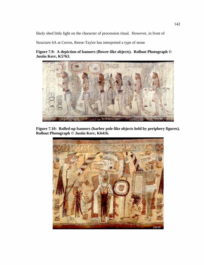
142
likely shed little light on the character of procession ritual. However, in front of
Structure 6A at Cerros, Reese-Taylor has interpreted a type of stone
Figure 7.9: A depiction of banners (flower-like objects). Rollout Photograph ©
Justin Kerr, K5763.
Figure 7.10: Rolled-up banners (barber pole-like objects held by periphery figures).
Rollout Photograph © Justin Kerr, K6416.

143
monument with holes drilled in it as a “bannerstone” (Figure 7.11). This large stone
block may have served as a stationary base in which to place banners at the termination
point of a procession (Reese 1996; Reese-Taylor 2002:154). As such, we are provided
with clues as to the setting of procession ritual. Other such stones have been found
associated with monumental architecture at Nakbe (Hansen 1993), Blue Creek (Guderjan
1998:107; and Weiss 1995, 1996), Copán (Fash et. al. 1992), and Dos Pilas (Demarest
2006; Demarest et. al. 2003:129).
Figure 7.11: Map indicating position of ‘bannerstone’ in relation to Cerros,
Structure 6A Complex. Redrawn from Reese-Taylor 2002.

144
Another form of circumstantial evidence in support of the procession may be
architectural. Based on the grand scale of some causeways (as well as their shorter
sibling the sacbe) some scholars have suggested that their primary purpose was ritual
rather than secular (see Scarborough 1994 for an example of their more mundane
functions). Andrews (1975:38) points out that, “Since the Maya had no wheeled vehicles
or domesticated animals, these spaces must have functioned as processional ways rather
than roads, permitting large numbers of people to proceed in mass from one sector of the
city to another.” He substantiates this statement with the observation that causeways
usually terminate at either end in important plazas associated with important buildings.
We will, not surprisingly, return to this idea later in the discussion with reference to the
formal path identified at Naachtun.
7.7 Discussion
In Section Two I have returned to the subject of procession ritual outlined in
Chapter 1. In this chapter I am continuing to build answers to the questions posed in the
introduction: 1) I have touched on some of the spatial and symbolic characteristics
required of the built environment for the successful completion of a procession ritual. 2)
I have provided examples of procession ritual and discussed the social, political, and
religious symbolism upon which they drew and wielded. 3) I have presented the basic
evidence for the existence of procession ritual in the Classic period and have outlined a
number of archaeologically driven interpretations of Classic period procession ritual.
From Classic period evidence alone we are able to say little about procession
ritual. Unfortunately while relatively extensive, this evidence (textual, iconographic, and
archaeological) speaks for procession ritual only indirectly; procession ritual itself leaves

145
no diagnostic archaeological remains. Nonetheless a number of suggestions may be
made with reference to the character and setting of procession ritual. We can say that
procession was an important element of ritual based on its prevalence in iconographic
representations. Its textual association with cosmogenesis similarly speaks to its probable
importance and suggests the likelihood that procession ritual was tied into cosmographic
features of the built environment (Chapter 3). This in turn fits well with architectural
evidence where both causeways and temple structures have been suggested to carry
cosmographic symbolism. Depictions of procession ritual from ceramic vessels and the
Bonampak murals have provided a glimpse of the more temporary material traces of
procession ritual as well. These include elaborate costumes, musical instruments,
military regalia and banners. These same depictions may be referred to in order to
suggest activities or events that may have prompted or incorporated procession ritual.
Principle among these, procession ritual seems to be associated with musical
performance, rituals of sacrifice, and tribute payment. From the Bonampak murals
specifically, procession ritual appears associated with ceremonies of state and the
designation and legitimization of the ruling elite. Finally, in the socio-political system
outlined in Chapter 3, and as suggested by the well-populated Bonampak murals, it seems
that procession ritual often served as a public spectacle, an example of vertical discourse
between the elite and non-elite members of society.
By incorporating ethnographic and ethnohistoric data, a more refined and
expansive model for procession ritual may be suggested. To begin, the mechanics of
procession ritual, regardless of the specific type of ritual in question, seem to be basically
the same. In procession ritual various nodes or points of articulation between levels of

146
the cosmos (Chapter 3) are connected to one another through the act of ritualised
movement. In circumambulation, the ritual performers metaphorically connect sacred
points on the horizon of their world model. Physically, these nodes may be represented
by mountain or hilltop shrines, by the corners of a field, by the posts of a house, or even
by the quarters of the human body. Symbolically, ritual circumambulation seems to
make reference to the time of creation, when the four corners of the world were laid out,
and indeed, this seems to be the source of its authority. Ritual tied to this behaviour
seems to agree with these suggestions. In ritual surrounding the building of a new house,
the planting of a field, the healing of the sick and in New Year ceremonies, the actors are
validating and claiming the delineated space through an act reflective of the creation of
the world itself; by creating it, they can exercise power over it.
In periphery/center, the ritual performers metaphorically connect cosmic nodes on
the periphery of their world with the axis mundi of the center. Physically, these
processions involve movement between a peripheral location (whether a distant
community or shrine, or simply the boundary of a town), and a central location
representing the axis mundi (this may be represented by a town site in general, a specific
building, or even a specific person). Symbolically, periphery/center procession seems to
serve as a unifying force. By connecting the edges of the world to the center they are
symbolically drawing the two together. And as suggested above, periphery/centre
processions may likewise be used to centre a person, place, thing, or action.
Periphery/center processions are also very much in tune with the larger ritual activities of
which they are a part. Whether these are New Year ceremonies (ethnohistoric) or days of
the patron saint (ethnographical), the types of ritual activity that incorporate

147
periphery/center procession tend to be public, highly visible, and effectively integrate a
community.
In base-to-summit processions, the performers are making a direct reference to the
layered cosmos, and indeed, this seems to be the most direct method of petitioning the
supernatural. Metaphorically, performers pass from one cosmic level to the next.
Physically, this is accomplished by connecting topographical locations representative of
the underworld (‘watery,’ or low places, caves or churches) with locations representative
of the upperworld (hilltop or mountain shrines). The journey always emphasises vertical
change though this is not necessarily a one-way performance and indeed is often cyclical
as the performers move from hilltop to hilltop, or metaphorically back and forth between
the cosmic levels. As the type of procession that most directly connects the three levels
of the cosmos, it seems apt that base-to-summit procession is most often associated with
direct petitions to the supernatural realm, whether asking for rain, water, or health, or to
present a newly initiated daykeeper.
Physically and conceptually all three forms of procession tend to overlap. This is
to be expected as all three types of ritual performance make reference to the same basic
cosmic model. It is also likely that overlap is intentional, designed to accomplish similar
goals in different ways. Repetitive ritual is to be expected. By repeating and rephrasing
ritual, performers are hedging their bets, making sure that the ritual is as likely to succeed
as possible and reinforcing concepts or messages that the ritual carries.
Finally, there is the issue of the temporalization of space seen in both Zinacantan
and Chamula. Among both groups of people, it is possible to move metaphorically

148
through time as one moves physically through space. As will be discussed in the
following chapter, space may be similarly temporalized at Naachtun.

149
Chapter Eight: Procession Ritual at Naachtun during the Late Classic Period
8.1 Introduction
In this chapter I search for common ground between the models of procession
ritual suggested at the end of the previous chapter and the physical and symbolic
landscapes of Naachtun as constructed in Section One. A hypothetical procession ritual
is suggested based on this common ground, physically located along the formal route,
and within the social, political, and religious setting of Late Classic Naachtun.
8.2 Processions at Naachtun
In the Late Classic site plan of Naachtun all three of the basic types of procession
discussed in the previous chapter (ritual circumambulation, periphery/centre, base-to-
summit-of-mountain) find potential expression. Spatially, circumambulatory processions
require no more than a space or object to walk around. They could be performed around
the site as a whole (Figure 8.1), around groups of structures within the site, or around any
of the many structures at Naachtun. Periphery/Centre processions only require a space to
walk through. This could mean movement from an outlying community to Naachtun’s
core, or from one structural group to another, or indeed movement clear from one side of
the site to the other. Base-to-summit processions only require a change in elevation.
This could mean processions from the central reservoir to a platform structure or simply
the mounting of a temple structure. It is likely that all three types of procession were
conducted in various locations around Naachtun throughout its history.

150
Figure 8.1: Rectilinear map of Naachtun’s core architecture.

151
8.2.1 Circumambulation at Naachtun
The most convincing suggestions for circumambulating processions at other sites
of the Classic period Maya area include Looper (1995) and Newsome’s (1991)
reconstructions of circuits running from stela to stela at Quiriguá and Copán
(respectively) and Reese-Taylor’s (2002) reconstructions of processions at Cerros,
Uaxactun and Tikal. Unfortunately, at Naachtun (Figure 8.1) stelae are typically laid out
in a very linear pattern that does not lend itself in any particularly obvious way to a
closed circuit type of procession. Neither does Naachtun seem to possess the obvious
architectural or iconographic markers used by Reese-Taylor (2002:147) to identify the
Six Sky, Eight House Partitions place at Cerros, Uaxactun and Tikal. Naachtun does
however have one structure that may have symbolic meaning as a place of creation. It
has been suggested that temple structures in triadic groups symbolize the ‘stones’ of the
original cosmic hearth (Freidel et al. 1993; Looper 1995:2), one of the first products of
creation. Structure I at Naachtun is an example of this type of structure (Figure 8.2) and
conveniently it is oriented very closely to the cardinal directions with the three principle
temple structures to the east, south and west and a small platform to the north. As such,
procession from temple structure to temple structure including the low mound may have
been interpreted as a symbolic reference to the laying out of the four directions much as
in Reese-Taylor’s reconstruction. Also very convenient is the fact that Structure I seems
to be the earliest monumental structure so far found on the site; by the time of the site’s
abandonment late in the 9th
century C.E., Structure I had been standing for nearly a

152
millennium (Walker and Alvarado 2005). For ritualists using this space at the end of the
Late Classic period (some of the most recently carved stelae at the
Figure 8.2: Naachtun, Structure I (triadic group); (a), (b), (c) indicate temple
structures, (d) indicates the small northern platform. The red path indicates
circumambulating procession.
site are found in Group C), Structure I may indeed have seemed old enough to have been
the place of creation.
8.2.2 Base-to-Summit at Naachtun
Base-to-Summit-type processions may be used for a number of purposes, most of
which involve direct petitions to the supernatural realm. As addressed in the previous
chapter, ethnographically, these types of procession take advantage of the natural high
and low topography of the particular landscape in question. Archeologically it has been
suggested that certain features of the built environment can take the place of those in
nature (Chapter 3). Following this, at Naachtun, we are interested in structures and
spaces that can replace those of the natural world. Specifically, low, watery places—at
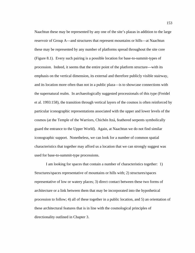
153
Naachtun these may be represented by any one of the site’s plazas in addition to the large
reservoir of Group A—and structures that represent mountains or hills—at Naachtun
these may be represented by any number of platforms spread throughout the site core
(Figure 8.1). Every such pairing is a possible location for base-to-summit-types of
procession. Indeed, it seems that the entire point of the platform structure—with its
emphasis on the vertical dimension, its external and therefore publicly visible stairway,
and its location more often than not in a public plaza—is to showcase connections with
the supernatural realm. In archaeologically suggested processionals of this type (Freidel
et al. 1993:158), the transition through vertical layers of the cosmos is often reinforced by
particular iconographic representations associated with the upper and lower levels of the
cosmos (at the Temple of the Warriors, Chichén Itzá, feathered serpents symbolically
guard the entrance to the Upper World). Again, at Naachtun we do not find similar
iconographic support. Nonetheless, we can look for a number of common spatial
characteristics that together may afford us a location that we can strongly suggest was
used for base-to-summit-type processions.
I am looking for spaces that contain a number of characteristics together: 1)
Structures/spaces representative of mountains or hills with; 2) structures/spaces
representative of low or watery places; 3) direct contact between these two forms of
architecture or a link between them that may be incorporated into the hypothetical
procession to follow; 4) all of these together in a public location, and 5) an orientation of
these architectural features that is in line with the cosmological principles of
directionality outlined in Chapter 3.

154
Only one plaza-platform combination meets these criteria at Naachtun. This
pairing is the East Plaza and, at the east end of the Avenida de las Estelas, Structure
XXXVIII. Not only are these structures/spaces appropriate in and of themselves for this
ritual but they are publicly accessible and oriented east-west (Figure 8.3). In this case,
the western end and the East Plaza is associated with the location of the setting sun into
Figure 8.3: Detail of Naachtun site core showing the location of the East Plaza,
Avenida de las Estelas, and Structure XXXVIII as well as the route connecting the
three.
the underworld (appropriately wet) and the eastern end and Structure XXXVIII is
associated with the location of the rising sun into the upperworld; an association that may
have highlighted the vertical symbolism. Another possible route would have tied the

155
large reservoir in Group A to Structure XXXVIII, but this path is much more circuitous.
A close parallel for this particular procession route, albeit oriented north-south, is evident
at the site of Chichén Itzá. In the North Precinct of this site the Cenote de Sacrificios
(representing a low, watery place) is connected, via a long causeway (Sacbe No. 1) to a
large radial pyramid (representing the ascent to the upper world). Indeed, this route at
Chichén Itzá may have provided the inspiration for the example at Naachtun, an idea that
ties in well with the Central Yucatecan-style architecture that is found in Naachtun Group
B.
As discussed in the previous chapter the goals of base-to-summit processions are
twofold. The first, the goal of the ritual itself, is to petition the supernatural realm. The
ritualists symbolically enter all three levels of the cosmos, an extremely powerful act, and
finish by bringing their petition directly to the upper supernatural world. In petitions for
rain, for example, this would mean that the ritualists take their message to the very home
of the Chaaks (god(s) of rain). The second goal, to fulfill the ritual obligations of the
ruling elite, is a little more complicated. Taken from Demarest’s theatre state model, it is
clear that for the ruling elite, as ritual specialists who connect the larger state to the
supernatural realm, their ability to rule is largely a product of their showmanship (the
degree for which this is true is open to debate)—their ability to convince their people that
they effectively communicate with the supernatural world, that they bring rain, ensure
prosperity, or guarantee victory in war. Hence, the second goal is largely reached
through the success of the first.

156
8.2.3 Periphery/Center at Naachtun
In the model for periphery/centre procession constructed in Chapter 7 the ritual
performers metaphorically connect cosmic nodes on the periphery of their world with the
axis mundi of the center. This act requires the presence of a number of physical and
symbolic elements including a space to move through marked by structures or features of
the natural environment that symbolically represent nodal points in the Classic Maya
world model. These spatial and symbolic requirements were included in Demarest’s
reconstruction of processions at Dos Pilas outlined in the previous chapter (Demarest
2006). Additional cosmological, social or political references based on directionality or
reflected in structures and spaces around the procession path may increase the symbolic
importance of the ritual. As made clear in Chapters 1 and 6, while procession (as with
performance in general) may be enacted at a variety of scales including the very small
and private, in this thesis I am discussing procession ritual as a public performance.
Continuing this discussion in this context I am interested in identifying these physical and
symbolic features of the environment in highly accessible or ‘public’ spaces. At
Naachtun these conditions may be met by proceeding along the formal route outlined in
Chapter 5, Section One.
The eastern and western ends of our proposed procession route (Figure 8.4) are
marked by temple platforms (Structures I and XXXVIII). It has already been noted that
temple platforms were seen as water-mountains, gateways to both the upper and lower
worlds. Further, if the site is taken as a cosmic model then it is likely that Structures I
and XXXVIII specifically represented the western and eastern mountains (nodal points)
of the Maya cosmic model. If there are peripheral nodal points, then there should also be

157
Figure 8.4: Map of Naachtun site core indicating Structures I, XIII, XIV, XXXVIII
and the path connecting them.
a central point. In this case the axis mundi may be represented, among a number of
alternatives, by the ballcourt in Group A (Structures XIII and XIV). It may be
remembered that the Popol Vuh states that ballcourts are close to both Heaven and
Xibalba, or the under and upper worlds. This is another permeable point between cosmic
levels.
But if all temple platforms and ballcourts act as cosmic nodes, what makes
Structures I and XXXVIII specifically representative of the western and eastern
mountains of the world model and what makes Structures XIII and XIV specifically
representative of the axis mundi? This identification is based partially on the locations of
the structures within the site center and in relation to one another (the temple platforms
are physically located on the edges while the ballcourt is more centralized) and partially
on the way in which the structures are connected (see Figures 8.1 and 8.4). Again,
following the world model outlined above, the edges of the world are linked to the center
by roads facing the cardinal directions. And indeed, at Naachtun it seems that Structure I

158
is linked to the ballcourt by a causeway. According to Classic period convention, this is
the black road, the road of the west and the only safe road to Xibalba (Tedlock, D.
1985:358). Structure XXXVIII is similarly linked to the ballcourt via the Avenida, an
elongated plaza that is similar in spatial dimension to a causeway, as well as a series of
plazas. This road is the red road, the road of the east.
Following the model of periphery/centre procession from the previous chapter, a
royal procession along this route may have served to symbolically integrate Naachtun and
legitimize the polity and its rulers by explicitly placing the city in the cosmic model. In
this act the rulers associate the awesome and unalterable supernatural forces of creation
with their semi-divine right to rule. But there may be an additional level of complexity in
this particular procession route.
Naachtun’s chronology as we know it indicates that it generally grew laterally
rather than vertically with Group C representing the oldest occupation followed by Group
A and finally Group B (Walker and Alvarado 2005). As a person physically moves along
this path, they are passing sequentially older or newer structures (depending on the
direction, west or east respectively, of travel). If we remember the concept of the
temporalization of space as recorded in ethnographies of modern Maya people (the
Chamulans and Zinacantecos, Chapter 7), then I suggest that, as one moves along the
procession route linking Groups C and B, one is metaphorically passing forward and
backward through time. A procession along this route may therefore not only locate
Naachtun within the cosmic model but establish it firmly in time. This affords the
ritualists using this path the opportunity to draw symbolic power from both the cosmic
realm and from the temporal realm.

159
8.2.3.1 A Hypothetical Reconstruction of Periphery/Center Procession at Naachtun
As periphery/center processions along the route described above tie a large
portion of the site together both spatially and temporally, a proposed reconstruction of
this type of procession allows me to address most fully the three questions posed at the
beginning of this thesis. Ethnohistorically, periphery/center-type procession has been
shown to be an element in New Year rituals (Tozzer 1941:139-142). Ethnographically
this type of procession may be incorporated into rituals in honour of the patron saints
(Vogt 1969, 1994) and, as in the example to follow, as part of the ritual surrounding the
inauguration of civic officials (Vogt 1976:129-130). This type of procession is
appropriate for activities of this nature for a number of generally functional reasons—
periphery/center processions are typically public and highly integrative, a seemingly ideal
forum in which to introduce a new ruler to his/her people. But at Naachtun,
periphery/center procession along the above outlined formal route is uniquely appropriate
for an inauguration ceremony. While the relationship between the sun’s path and the
procession route (a fact that would not likely have been lost on any of the ritual
participants or spectators involved in the ritual) has already been mentioned (Chapter 5),
as has the possible temporalization of this route, it will be seen that this is not the only
meaning that may emerge through the ritual act.
Our hypothetical procession begins with the accession of a new ruler toward the
end of the Late Classic period. At this point in its history, Naachtun was experiencing a
growth spurt. While this suggests a measure of prosperity it may also suggest instability
(Sharer 1985). This hypothesis is supported by conflicting textual and architectural
evidence. While an exhumation ritual attended by both a Tikal and a Masul lord at this

160
time (corresponding to a resurgence of Tikal’s power after ‘the hiatus’ covered in
Chapter 5) suggests an amiable relationship between these two states, the presence of
Central Yucatecan style architecture in Structures XXXIX and XL suggests an affiliation
with that region, or alternatively, an effort to distinguish itself from Tikal. If this is the
case, and Naachtun was struggling to find solid footing in the turbulent Late Classic, then
it stands to reason that a newly established ruler may have had a need to establish firmly
and directly, without question, his/her right to rule.
The purpose of this ritual is therefore twofold: 1) To validate the new ruler’s
right to rule by depicting him/her as the logical outcome of historical events begun deep
in the past of the city (most likely with no small amount of spin-doctoring).
Simultaneously this act ties him/her to aspects of Maya religion and specific events in the
creation myth, thereby giving him/her supernatural validation (this following the idea that
ritual specialization is the basis for rulership (i.e. Demarest 2005)). An example of these
concepts in text and image is found on Tikal Stela 31 (front). This stela, carved in an
antiquarian style, may have been intended to tie the individual depicted to past rulers
(Greene 1967). The deity peering down at the individual from the top of the stela
establishes the tie to the supernatural world (Greene 1967). 2) This ritual integrates the
community, bringing it together to witness the new ruler’s accession (ritual has little
effect as a power base if it is not witnessed). It can be expected that messages will be
repeated again and again throughout the course of the ritual in an attempt to reinforce
them.
Group C (Figure 8.5) is a collection of structures located atop a large natural
terrace. Once the heart of Naachtun’s civic and ceremonial world, by the Late Classic

161
Figure 8.5: Detail of Naachtun Group C.
period, Group C is isolated on the western side of the site core. The procession begins at
Structure I, a large platform with three temple structures and a small northern platform
set atop (the whole being oriented generally in accordance with the cardinal directions); a
collection of stelae, most plain, stand in front (to the north) of this structure. Structure I
itself is one of the oldest in the site core, being constructed sometime between 8.0.0.0.0
(41 C.E.) and 8.6.0.0.0 (159 C.E.). At the time of its construction, Naachtun was small,

162
just beginning a course through history that would actively stretch nearly a millennium.
By beginning the procession in this location the new ruler is symbolically stating that
his/her beginning is tied to that of Naachtun itself.
In all likelihood the ritual act begins before the procession, at Structure I,
potentially involving a reference to the story of the creator figure ‘First Father’ (the
Maize God) and his brother, and the parallel story of his children, the Hero Twins. As
the Maize God entered Xibalba through the western water-mountain, the ruler’s entrance
and re-emergence from the temple structures atop Structure I (the symbolic western
water-mountain of Late Classic Naachtun’s site plan) may initiate a series of references
to the story of the Maize God and his children that will continue throughout the ritual.
Circumambulating procession at this structure may reflect the act of creation,
effectively tying the beginning of Naachtun to the beginning of the world itself and the
ruler taking part in the ritual. Further, while general claims of ancestry may be made by
referencing the structure itself, it is possible that the new ruler could use this location to
make explicit claims of his/her ancestry. Through ritualized bloodletting and petition it
was possible for the nobility to contact their ancestors (Freidel et al. 1993:204-207;
Schele and Miller 1986:178-179; Sharer and Traxler 2006:149, 436). It is often assumed
that this activity would be performed publicly atop pyramidal platforms (a location
uniquely appropriate for this behaviour as a result of its cosmographic closeness to the
upper supernatural realm).
Indeed, the links between the ancestors and Structure I seem to be confirmed
archaeologically. Within the small northern platform of Structure I the Classic period
Maya ritualistically entombed Stela 26, the stone image of a former ruler. Finally, the

163
ritual act may have involved the ‘reading’ of stelae (as has been suggested at Copán)
thereby tying the ruler to other events and figures in Naachtun’s past.
After this is completed, the procession moves east. Amidst pomp and splendour,
the procession probably includes the ruler bedecked in all his/her finery including jade
ear ornaments and quetzal feathers and accompanied by musicians, dancers, and banner-
bearers as in the Bonampak murals, as well as other attendants, nobility, and a throng of
common spectators. The path would carry the ritualists and spectators alike past a series
of densely packed structures, most of which are low platforms (these were likely
incorporated into Group C by 238 C.E.) and stelae (possibly read en route and dating
mostly to the Late Classic period), before bringing into view the immense form of the
acropolis (Structure V). Constructed around the same time as Structure I, Structure V
consists of a very large platform supporting at least two temple structures and six
additional platforms.
From here, the procession descends off of the terrace and follows the sacbe or
causeway running toward Group A, symbolically representative of the western road in
the world model. To the north along this path stands La Perdida, a fifteen metre tall
pyramidal platform, which, at one time faced its twin, Structure XX, across one hundred
fifty meters of open space. A large fortified compound looms to the south of the path. A
reminder of tumultuous times, this bastion was constructed sometime before 554 C.E.
and may be related to increasing aggression from Tikal (by this time very-much a ‘super
power’ of the Maya world) known to have ‘axed’ the seat of the Masul Lord in 9.2.11.7.8
(486 C.E).

164
When the causeway ends, a gradual upward climb brings the procession to
Structures XIII and XIV (constructed by as early as 9.6.0.0.0, 554 C.E.), that together
form a ballcourt, the symbolic axis mundi. It too is fronted by what is now a blank stela.
While physically unassuming, the potential symbolic significance of this location is
immense. Fox discusses ballcourts in general as boundary markers (1996); to pass
through one is to symbolically enter a new space. This symbolism is highlighted at
Naachtun where the ballcourt, as the axis mundi, represents the halfway point of the
procession ritual. Further, as a demonstrated articulation point between all three levels of
the cosmos ballcourts in general are innately powerful, ritual conducted there being
buoyed up by supernatural forces. Indeed, it is a location from which petitions to these
forces could be made. Moreover, much in the same way that circumambulating
processions claim or even create space by tracing its borders, it is possible that
identification of the axis mundi within Naachtun’s core identifies Naachtun symbolically
as the very place of creation and strengthens any claims made to supernatural power
throughout the ritual. And finally, as has already been discussed, the ballcourt factors
heavily in the creation myth of the Maya. A reference to the Xibalban exploits of the
Maize God or the Hero Twins at this point would be fittingly paired with the ritual act
already performed at Structure I and in anticipation of the final ritual act to be performed
at the end of the path.
Following this, the procession likely continues from the axis mundi along a path
symbolizing the eastern road in the world model. This path leaves the ballcourt, and
passes along the northern boundaries of the West and South plazas. The view of the
monumental core is dramatic along this path. To the south stretches a vast plaza nearly

165
one hundred fifty meters east-west by one hundred meters north-south (Figure 8.6). The
West Plaza is bound to the west by the aforementioned fortified compound, to the south
Figure 8.6: Detail of Naachtun Group A.
by pyramidal platforms XV and XVII, the palace-type Structures XVI and XVIII and
with the site’s main reservoir occupying the southeast corner. To the north, the plaza is
bound by the raised bulk of the North Plaza and its monumental architecture, some of the
largest in the site core (completed by late in the third century C.E.). The North Plaza also
holds some stylistic evidence of influence from the south (possibly the result of
emulation much as Ashmore (1986) describes at Quiriguá); this in the guise of the Nakbe
and El Mirador-inspired E-group (Structures XXII and XXIII). A linear arrangement of
stelae, all of later date than the surrounding structures, marks the procession route to the

166
south of Structures XX and XIX. These stelae were clearly positioned to be accessible to
ritualists using this space, and as the procession moves east it is likely that their content is
read aloud to ritualists and spectators alike.
Passing through the South Plaza, the procession then enters the much-more-
confined East Plaza (Figure 8.7). This smaller plaza, similar in size to the South Plaza,
was constructed some time between 9.6.0.0.0 (554 C.E.) and 9.11.0.0.0 (652 C.E.). At
this time Naachtun was likely relatively free of the influence of Tikal, this phase of
construction corresponding to the well-known ‘hiatus’ at that center. This plaza, studded
with stelae, each presumably read in turn, draws the procession along its length. The
dominant path of movement leads from the northwest corner of the plaza and the
dominating façade of Structure XXV south past two very long palace-type structures to
the southeast corner controlled by Structure XXX.
Lastly, the procession heads east along the Avenida de las Estelas. Less a
causeway than an elongated plaza defined by the structures and terraces to the north and
south, the Avenida rises as one proceeds east (while as-of-yet unexcavated, this is likely
accomplished by ramps or stairs) past stelae and altars, terminating at Structure
XXXVIII. This is the most recently constructed section of Naachtun (9.11.0.0.0 –
10.3.0.0.0, 652-889 C.E.). With its sprawling palace-type architecture and the ‘Central
Yucatecan’ influenced Structures XXXIX, and XL, this is the first architectural evidence
for a relationship with northern centers. Further, Peuramaki-Brown (2006) suggests that
the prominent display of strong (ruling) women on stelae, such as on Stela 19 in front of
Structure XXXVIII, is a characteristic pattern in the Kaan kingdom (at this time centered
on Calakmul).

167
Figure 8.7: Detail of Naachtun Group B.
And yet, there is clearly confusion at this point in Naachtun’s history. The
documented joint participation of the rulers of Masul and Tikal in an exhumation ritual
and reburial in this period followed by the decisive defeat of Calakmul by a newly
dominant Tikal in 695 C.E. as well as the depiction of a Naachtun Lady standing atop a
bound captive from Ox-te-tun (Naachtun Stela 19, located beside the west staircase of
Structure XXXVIII) suggests that Naachtun is still very much tied to the south. As

168
already stated, it is this extended period of turbulence in Naachtun’s history that may
have sparked the procession ritual here suggested.
In a final ritual act, the new ruler ascends the radial pyramid (Structure XXXVIII)
and enters the temple atop (in a base-to-summit procession) symbolizing a return to the
middle world, and in emulation of the rebirth of the life-giving Maize God, or indeed, the
Hero Twin Hunahpu, re-emerges from the east as the sun, the ultimate demonstration of
his/her power and validation of his/her rulership completed.
8.3 Discussion
As presented above, the purpose of this ritual is twofold: 1) To validate the ruler
of Naachtun’s right to rule by depicting him/her as the logical outcome of historical and
supernatural processes 2) To integrate the community, bringing it together to witness the
new ruler’s accession. The second goal is easy enough to deal with immediately as the
very nature of this type of procession as well as its setting along the major thoroughfare
of Naachtun’s site core would tend to draw witnesses. The first goal however is best
discussed in two parts.
The first goal, to validate the ruler’s accession through references to history and
mythology, may be thought of as two separate symbolic paths through the same physical
space. While the ultimate goal is the same in both instances, the ways in which each
‘symbolic’ path uses space are distinctive. In order to tie the new ruler into the line of
past rulers the ritualists take advantage of what McAnany (1995) calls the ‘principle of
first occupancy.’ Simply put, one’s position in the hierarchical organization of a site is
suggested to be related to the history of one’s particular lineage at that site. For the new
ruler, a legitimate kin tie to Naachtun’s previous rulers was indeed possible. However,

169
even if the kin tie did not exist, the ruler may have been able to use the temporal aspect of
the procession route—beginning in Naachtun’s deep past at Group C and moving forward
to the new ruler’s present in Group B—to make a statement of his/her heritage.
Following the principle of first occupancy, he/she would have likely placed him/herself
and his/her lineage within the deep past of the site. These ties would have been inferred
time and again as the procession effectively wrote the new ruler into the history book that
is the architecture along this procession route. At Naachtun, as at Quiriguá (Looper
1995), architecture, space, and the ritual that utilized them constituted the narrative media
represented by elaborate images and text at other sites (such as Tikal Stela 31).
In order to tie the ruler into the supernatural realm the ritualists may have used the
procession in yet a different way. For this they would have called on aspects of
Naachtun’s built environment, and of the procession route in particular, that reflect
cosmological ideals or scenes from myth. The west-east directionality of the path
coupled with architectural features analogous to the western and eastern mountains with
their associated roads leading to the axis mundi fits well with the world model in which
the sun follows this path east to west daily in the upper world and west to east (the
direction of our procession) nightly in the underworld (Xibalba). In this way the ruler
may be emulating the sun’s nightly path through the underworld (emphasizing the
removal of the ritual act from normal daily events), and indeed claiming an association
with this deity.
The association of the ruler with the cosmic realm is only strengthened by ritual
re-enactments of some of the key events in the myths of the creation myth, a feat
facilitated by both the direction of the procession and the specific architectural features

170
along the path. At the western water-mountain (Structure I) the ruler may have
symbolically entered the underworld, just as the Maize God did in the Popol Vuh.
Following the procession to the ballcourt (along which elements of either the Maize
God’s and/or the Hero Twins’ journey may have been represented), ritual activity at this
location may have re-enacted the Hero Twins’ and their father’s struggles for life and
death against the Xibalbans. And finally the procession would have drawn the ritualists
to the eastern water-mountain (Structure XXXVIII) where the ruler would symbolically
re-emerge from death as the Maize God or transform him/herself into the reborn sun just
as did the Hero Twin Hunahpu. In this way the new ruler may have demonstrated his/her
ritual powers and tied his/her claim to rule to the very fabric of creation.
In this chapter I laid out some common ground between the models of procession
ritual suggested in Chapter 7 and the physical and symbolic landscapes of Naachtun as
constructed in Section One. A number of potential procession routes were outlined. In
order to draw together the concepts associated with procession ritual in this thesis, one
hypothetical ritual in particular was discussed, physically located along the formal route,
and within the social, political, and religious setting of Late Classic Naachtun. In the
following, concluding, chapter, this reconstruction will be referenced in order to answer
the three questions posed in Chapter 1.

171
Chapter Nine: Summary and Final Thoughts
9.1 Introduction
At the outset of this thesis three questions in particular were posed of Maya
procession ritual in the Classic period: 1) What spatial and symbolic characteristics were
required of the built environment for the successful completion of a procession ritual? 2)
How were society, politics, religion and ritual interrelated, and how could the act of ritual
procession relate to these interactions? 3) Specifically, can evidence be seen for
procession ritual archaeologically and what can be suggested of it in the context of
Naachtun? In an effort to address these questions, and following a rather circuitous route,
I have touched on the physical, socio-political, and cosmological environments of the
Maya area in general and of Naachtun in particular. I have discussed site planning
principles related to these environments. I have presented the evidence for Classic period
procession ritual and its ethnographically recorded counterpart, and generated a basic
model for this behaviour. In this chapter I have brought it all together to suggest a
number of processions that may have been supported by the physical and symbolic
environment of Naachtun and the socio-political and religious context of Naachtun in the
Late Classic period. If I have been successful thus far we should now be in a position to
forward some answers to those questions initially posed.
9.2 Summary
The first question, “What spatial and symbolic characteristics were required of the
built environment for the successful completion of a procession ritual?” is the most basic
of the questions asked and was discussed primarily in Chapter 7. Fundamentally,
procession ritual is tied to cosmographical locations (cosmologically charged structures

172
and spaces). The term indicates the ritual movement of actors from perceived nodes in
the cosmic model that serve as access points between levels of the cosmos. In form,
procession ritual can be broken into three categories, each with its own particular
symbolic and spatial requirements: Circumambulation, Periphery/Center, and Base-to-
Summit.
In circumambulating processionals, the ritual performers metaphorically connect
sacred points on the horizon of their world model. Physically, these nodes may be
represented by mountain or hilltop shrines, by the corners of a field, by the posts of a
house, or even by the quarters of the human body; the point is that a specific space is
circumscribed. Symbolically, ritual circumambulation seems to make reference to the
time of creation, when the four corners of the world were laid out.
In periphery/center processionals, the ritual performers metaphorically connect
cosmic nodes on the periphery of their world with the axis mundi of the center.
Physically, these processions involve movement between a peripheral location (whether a
distant community or shrine, or simply the boundary of a town), and a central location
(whether a town site in general, a specific building, or even a specific person) always
representing the axis mundi. Symbolically, periphery/center procession seems to serve as
a unifying force. By connecting the edges of the world to the center they are
symbolically drawing the two together. And as suggested above, periphery/centre
processions may likewise be used to centre a person, place, thing, or action.
In base-to-summit processionals, the performers are making a direct reference to
the layered cosmos, and indeed, this seems to be the most direct method of petitioning the
supernatural. Metaphorically, performers pass from one cosmic level to the next.

173
Physically, this is accomplished by connecting topographical locations representative of
the underworld (‘watery,’ or low places, caves or churches) with locations representative
of the upperworld (hilltop or mountain shrines). The journey always emphasises vertical
change though this is not necessarily a one-way performance and indeed is often cyclical
as the performers move from hilltop to hilltop, or metaphorically back and forth between
the cosmic levels.
Physically and conceptually all three forms of procession tend to overlap. This is
to be expected as all three types of ritual performance make reference to the same basic
cosmic model. It is also likely that overlap is intentional, designed to accomplish similar
goals in different ways. Repetitive ritual is to be expected. By repeating and rephrasing
ritual performers are making sure that the ritual is as likely to succeed as possible and
reinforcing concepts or messages that the ritual carries.
The second question, “How were society, politics, religion and ritual interrelated,
and how could the act of ritual procession relate to these interactions?” can be answered
by looking to Chapters 3, 6, and 7. It should be clear from the discussion in Chapter 3
that, as variable as Maya social, political and religious systems were, the common thread
that unites all models of these systems is their extremely high degree of interrelation; so
much so that it is inconceivable that one could effectively discuss any one part of the
system (such as politics or religion) without addressing a number of other parts. It is
clear that political systems are derivative of social divisions and that religion is often
structured to support these divisions.
Further, it is clear that ritual could be employed to manipulate this system. In
Chapter 6 I discussed the role of public performance in integrating and delineating a

174
community and in supporting the creation and maintenance of the social order. I have
emphasized the ‘theatre state model’ (Chapter 3 and Section Two) outlined by Tambiah
(1976, 1977) and championed in the Maya area by Demarest (1992, 2004:206) as
suggesting a convincing element in the power base of the Maya elite. In this and the
previous chapter I have illustrated the ways in which procession ritual, as a form of
public performance, relates to and draws on the social, political, and religious spheres;
how it can be used to integrate and delineate a community, and how it may play a part in
the creation and maintenance of the social order by calling on the ‘unalterable facts’ of
history and religion.
Finally, “Specifically, can evidence be seen for procession ritual archaeologically
and what can be suggested of it in the context of Naachtun?” This question was initially
addressed in the introduction and has been built on in Chapters 4, 5, and 7. As indicated
in the introductory chapter, procession ritual leaves no diagnostic material traces to be
found archaeologically. Nonetheless, it has been shown (Chapter 7) that there is ample
evidence for the existence of procession ritual in the Classic period, and with careful
attention paid to the ethnographic record we can begin the fill in a model of this
behaviour (as above).
In the context of Naachtun specifically, I am able to suggest much about
procession ritual. As discussed in this chapter, within the site core of Naachtun exists an
environment both symbolically and spatially appropriate for the gamut of procession
ritual types. The Maya constructed an environment particularly appropriate for
periphery/centre processions during the Late Classic period (this chapter) and one that
appears to have been formally recognized and maintained (Chapter 5). This environment

175
also affords us the opportunity to suggest a level of temporal symbolism seen in
ethnographic processionals but not typically obvious in archaeological reconstructions.
While at other sites—Dos Pilas (Demarest 2006), Cerros, Uaxactun, and Tikal (Reese-
Taylor 2002)—temporal references to the mythological past may be suggested through
cosmological references to the creation myth, at Naachtun, the site’s lateral pattern of
growth (as opposed to vertical and radial) has created an environment that may literally
reflect the passage of time (as suggested in the reconstruction above). I do not mean to
suggest that temporal references of this kind were necessarily made at Naachtun or
intentionally incorporated into Naachtun’s site plan, but I do think it highly likely that
this feature of Naachtun’s built environment was recognized by the people who lived
there and that it could have been referenced through the act of ritual procession.
9.3 Further Research
Until they come up with a DVD player with a really, really good rewind feature
seeing procession ritual in the built environment of Classic Maya city centres will be a
task for the imagination. We will be stuck discussing what ‘could have been,’ rather than
what necessarily ‘was.’ Again, the problem with concretely identifying procession ritual
in the archaeological record stems back to the transient nature of the ritual. Discussions
of this topic will always be something like building a very unstable house of cards.
While this may never change, we may be able to strengthen our foundation with a
bulk of circumstantial evidence. It is improbable that anything on on the order of the
Bonampak murals will be found at Naachtun directly tying an event in the history of
Naachtun to a specific ritual event, however, a number of other things could be done at
the site given enough time and money. Continuing archaeological investigation will

176
undoubtedly reveal more information on structure use and symbolism that may be tied
into the hypothetical processions outlined above. Will excavation of Structure I reveal
iconographic motifs concretely linking it with the underworld, identifying it as a water-
mountain, as a place of creation or as a home for the ancestors? Will Structure XXXVIII
indeed prove to be associated with concepts of the upper world? Can we find physical
evidence of the use of the processional path outlined above (can we look at compactness
or degradation of plastered plaza surfaces)? And indeed, as our understanding of Classic
Maya politics, society, religion, and ritual in general improves, so too will our ability to
interpret what scant evidence we have.

177
References
Adams, Richard E. W.
1970 Suggested Classic Period Occupational Specialization in the Southern
Maya Lowlands. In Monographs and Papers in Maya Archaeology,
edited by William R. Bullard, Jr., pp. 489-502. Papers of the Peabody
Museum of American Archaeology and Ethnology 61. Harvard
University, Cambridge.
1991 The Maya Lowlands Archaeological Project of the University of Texas at
San Antonio. Mexicon 13(2):22-24.
1998 Río Azul: A Classic Maya City. University of Oklahoma Press, Norman.
Anderson, Benedict
1991 Imagined Communities: Reflections on the Origins and Spread of
Nationalism. 2nd
edition. Verso, London.
Andrews, Anthony P.
1990 The Fall of Chichen Itza: A Preliminary Hypothesis. Latin American
Antiquity 1:258-267.
Andrews, Anthony P. and F. Robles C.
1985 Chichen and Coba: An Itza-Maya Standoff in the Early Postclassic
Yucatan. In The Lowland Maya Postclassic, edited by Arlen Chase and
Prudence Rice, pp. 62-72. University of Texas Press, Austin.
Andrews, E. Wyllys V. and Jeremy Sabloff
1986 Classic to Postclasic: A Summary Discussion. In Late Lowland Maya
Civilization: Classic to Postclassic, edited by Jerem Sabloff and E. W.
Andrews V, pp. 433-456. University of New Mexico Press, Albuquerque.
Andrews, George F.
1975 Maya Cities: Placemaking and Urbanization. University of Oklahoma
Press, Norman.
Ashmore, Wendy
1986 Peten Cosmology in the Maya Southeast: An Analysis of Architecture
and Settlement Patterns at Classic Quirigua. In The Southeast Maya
Periphery, edited by Patricia A. Urban and Edward M. Schortman, pp. 35-
49. University of Texas Press, Austin.
1989 Construction and Cosmology: Politics and Ideology in Lowland Maya
Settlement Patterns. In Word and Image in Maya Culture, edited by
William F. Hanks and Don S. Rice, pp. 272-286. University of Utah
Press, Salt Lake City.
1991 Site-Planning Principles and Concepts of Directionality among the
Ancient Maya. Latin American Antiquity 2(3):199-226.
1992 Deciphering Maya Architectural Plans. In New Theories on the Ancient
Maya, edited by Elin C. Danien and Robert J. Sharer, pp. 173-184.
University Museum, University of Pennsylvania, Philadelphia.
Ashmore, Wendy and Jeremy A. Sabloff
2002 Spatial Orders in Maya Civic Plans. Latin American Antiquity. 13(2):201-
215.

178
2003 Interpreting Ancient Maya Civic Plans: Reply to Smith. Latin American
Antiquity. 14(2):229-236.
Aveni, Anthony F., and Horace Hartung
1986 Maya City Planning and the Calendar. Transactions of the American
Phlosophical Society 76(7).
Bafna, Sonit
2001 Space syntax: a brief introduction to its logic and analytical techniques.
Environment and Behavior. 35(1):17-29.
Bassie-Sweet, Karen
2002 Corn Deities and the Male/Female Principle. In Ancient Maya Gender
Identity and Relations, edited by Lowell S. Gustafson and Amelia M.
Trevelyan, pp. 191-226. Bergin and Garvey, Westport.
Becker, Marshall J.
1973 Archaeological Evidence for Occupational Specialization Among the
Classic Period Maya at Tikal, Guatemala. American Antiquity 38:396-406.
Bey, George J., and William M. Ringle
1989 The Myth of the Center: Political Integration at Ek Balam, Yucatan,
Mexico. Paper presented at the 54th
annual meeting of the Society for
American Archaeology.
Blanton, Richard E.
1978 Monte Albán: Settlement patterns at the ancient Zapotec capital.
Academic Press, New York.
Brady, James E.
2001 Uncovering the Dark Secrets of the Maya: The Archaeology of Maya
Caves. In Maya: Divine Kings of the Rainforest, edited by Nikolai Grube,
pp. 296-307. Könemann Verlagsgesellschaft, Cologne.
Bricker, Victoria R.
1983 Directional Glyphs in Maya Inscriptions and Codices. American Antiquity
48:347-353.
Brown, Denise F.
1995 Un Espaio Constuido Efímero: Las Alfombras de Aserrín en Huamantla,
Tlaxcala. In Hacia una Antropología Arquitectónica, edited by Mari-Jose
Amerlinck, pp. 157-168. Universidad de Guadalajara, Guadalajara.
Brown, Linda A.
2004 Dangerous Places and Wild Spaces: Creating Meaning with Materials and
Space at Contemporary Maya Shrines on El Duende Mountain. Journal of
Archaeological Method and Theory. 11(1):31-58.
Bullard, Jr., William R.
1960 Maya Settlement Patterns in Northeastern Petén, Guatemala. American
Antiquity 25:355-372.
1964 Settlement Pattern and Social Structure in the Southern Maya Lowlands
during the Classic Period. Actas y Memorias, XXV Congreso Internacional
de Americanistas, México, 1962, vol. I, pp. 278-287.

179
Butler, Judith
1993 Bodies That Matter: On the Discursive Limits of “Sex.” New York,
Routledge.
Carrasco, David, Lindsay Jones, and Scott Sessions, eds.
2000 Mesoamerica’s Classic Heritage: From Teotihuacan to the Aztecs.
University Press of Colorado, Niwot.
Carlson, John B.
1981 A Geomantic Model for the Interpretation of Mesoamerican Sites: An
Essay in Cross-Cultural Comparison. In Mesoamerican Sites and
Worldviews, edited by Elizabeth P. Benson, pp. 143-215. Cumbarton
Oaks, Washington, D.C.
1982 The Structure of Mayapan: A Major Post-Classic Maya Site in Northern
Yucatan. Lateinamerika Studien. 10:43-62.
Carmack, Robert M.
1966 La Perpetuación del Clan Patrilineal en Totonicapan. Antropología e
Historia de Guatemala 18(2):43-60.
Chase, Arlen F.
1992 Elites and the Changing Organization of Classic Maya Society. In
Mesoamerican Elites: An Archaeological Assessment, edited by D. Z.
Chase and A. F. Chase, pp. 30-49. University of Oklahoma Press,
Norman.
Chase, Arlen F. and Diane Z. Chase
1992 Mesoamerican Elites: Assumptions, Definitions and Models. In
Mesoamerican Elites: An Archaeological Assessment, edited by D. Z.
Chase and A. F. Chase, pp. 3-17. University of Oklahoma Press, Norman.
Chase, Arlen F., Nikolai Grube, and Diane Z. Chase
1991 Three Terminal Classic Monuments from Caracol, Belize. Research
Reports on Ancient Maya Writing 36.
Chase, Diane Z.
1985 Ganned but Not Forgotten: Late Postclassic Archaeology and Ritual at
Santa Rita Corozal, Belize. In The Lowland Maya Postclassic, edited by
Arlen F. Chase and Prudence M. Rice, pp. 104-125. University of Texas
Press, Austin.
1992 Postclassic Maya Elites: Ethnohistory and Archaeology. In
Mesoamerican Elites: An Archaeological Assessment, edited by D. Z.
Chase and A. F. Chase, pp. 118-134. University of Oklahoma Press,
Norman
Chase, Diane Z., Arlen F. Chase, and William A. Haviland
1990 The Classic Maya City: Reconsidering “The Mesoamerican Urban
Tradition.” American Anthropologist 92:499-506.
Christenson, Allen J.
2003a Popol Vuh: The Sacred Book of the Maya: The Great Classic of Central
American Spirituality, Translated from the Original Maya Text, vol. 1. O
Books, Oakland.

180
2003b Popol Vuh: The Sacred Book of the Maya: The Great Classic of Central
American Spirituality, Translated from the Original Maya Text, vol. 2. O
Books, Oakland.
Coben, Lawrence S. and Takeshi Inomata
2006 Prologue, Behind the Scenes: Producing the Performance. In
Archaeology of Performance: Theaters of Power, Community, and
Politics, edited by Takeshi Inomata and Lawrence S. Coben, pp. 3-7.
Altamira Press, Oxford.
Coe, Michael D.
1965 A Model of Ancient Community Structure in the Maya Lowlands.
Southwestern Journal of Anthropology 21(2):97-114.
1999 The Maya. 6th
edition. Thames and Hudson, London.
Coe, Michael D. and Mark Van Stone
2001 Reading the Maya Glyphs. Thames & Hudson Ltd., London.
Coggins, Clemency C.
1980 The Shape of Time: Some Political Implications of a Four-Part Figure.
American Antiquity 45:727-739.
Culbert, T. Patrick
1991 Polities in the Northeast Peten, Guatemala. In Classic Maya Political
History: Hieroglyphs and Archaeological Evidence, edited by T. P.
Culbert, pp. 128-146. Cambridge University Press, Cambridge.
Cutting, Marion
2003 The Use of Spatial Analysis to Study Prehistoric Settlement Architecture.
Oxford Journal of Archaeology 22(1):1-21.
Dawson, Peter C.
2000 Space syntax analysis of Central Inuit snow houses. Journal of
Anthropological Archaeology. 21:464-480.
2003a Analysing the effects of spatial configuration on human movement and
social interaction in Canadian Arctic communities. Proceedings, 4th
International Symposium on Space Syntax, London.
2003b Examining the impact of Euro-Canadian architecture on Inuit families
living in Arctic Canada. Proceedings, 4th
International Symposium on
Space Syntax, London.
de Montmillin, Olivier
1988 Tenam Rosario – A Political Microcosm. American Antiquity 53:351-370.
1989 The Arhaeology of Political Structure: Settlement Analysis in a Classic
Maya Polity. Cambridge University Press, Cambridge.
Demarest, Arthur
1992 Ideology in Ancient Maya Cultural Evolution: The Dynamics of Galactic
Polities. In Ideology and Pre-Columbian Civilizations, edited by Arthur
A. Demarest and Geoffrey W. Conrad, pp. 135-157. School of American
Research Press, Santa Fe.
1993 The Violent Saga of a Maya Kingdom. National Geographic 183:94-111.

181
1996 War, Peace, and the Collapse of a Native American Civilization. In A
Natural History of Peace, edited by Thomas Gregor, pp. 215-248.
Vanderbilt University Press, Nashville.
2004 Ancient Maya: The Rise and Fall of a Rainforest Civilization. Cambridge
University Press, New York.
2006 Sacred and Profane Mountains of the Pasión: Contrasting Architectural
Paths to Power. In Palaces and Power in the Americas: From Peru to the
Northwest Coast, edited by Jessica Joyce Christie and Patricia Joan Sarro,
pp. 117-140. University of Texas Press, Austin.
Demarest, Arthur A. and H. Escobedo
1996 El Proyecto Arqueológico Punta de Chimino: Objectivos,
Descubrimientos, Interpretaciones Preliminares. In IX simposio de
investigaciones arqueológicas en Guatemala. Museo Nacional de
Arqueología y Etnología, Guatemala.
Demarest, Arthur A., T. Inomata, H. Escobedo and J. Palka
1991 Proyecto Arqueológico Regional Petexbatun: Informe Preliminar 3,
Tercera Temporada. Instituto de Antropología e Historia de Guatemala,
Guatemala.
Demarest, Arthur, Kim Morgan, Claudia Wolley, and Héctor Escobedo
2003 The Political Acquisition of Sacred Geography: The Murciélagos
Complex at Dos Pilas. In Maya Palaces and Elite Residences: An
Interdisciplinary Approach, edited by Jessica Joyce Christie, pp. 120-153.
University of Texas Press, Austin.
Diehl, Richard
1983 Tula. Thames and Hudson, London.
Dunning, Nicholas P.
1992 Lords of the Hills: Ancient Maya Settlement in the Puuc Region, Yucatán,
Mexico. Monographs in World Archaeology No. 15. Prehistory Press,
Madison.
Eliade, Mircea
1964 Shamanism: Archaic Techniques of Ecstasy. Routledge and Kegan Paul,
London.
Proceedings, 4th
International Symposium on Space Syntax, London.
Fash, Barbara, William Fash, Sheree Lane, Rudy Larios, Linda Schele, Jeffrey Stomper,
and David Stuart
1992 Investigations of a Classic Maya Council House at Copán. Journal of
Field Archaeology 19:419-442.
Fash, William F.
1988 A New Look at Maya Statecraft from Copan, Honduras. Antiquity 62:157-
159.
1991 Scribes, Warriors and Kings. Thames and Hudson, London.

182
Folan, William J., Joel Gunn, Jack D. Eaton, and Robert W. Patch
1983 Paleoclimatological Pattening in Southern Mesoamerica. Journal of Field
Archaeology 10:453-468.
1992 Calakmul, Campeche: A Centralized Urban Administrative Center in the
Northern Peten. World Archaeology 24:158-168.
Foley, Joan E. and Annabel J. Cohen
1984 Mental Mapping of a Megastructure. Canadian Journal of Psychology.
38(3):440-453.
Foucault, Michel
1977 Discipline and Punish: The Birth of the Prison, translated by A. Sheridan.
Pantheon, New York.
Fox, John W.
1987 Maya Postclassic State Formation. Cambridge University Press,
Cambridge.
1991 Factionalism Among the Postclassic Quiché Maya: The Calendar for
Competition and Cooperation. In Factional Competition and Political
Development in the New World, edited by E. Brumfield and J. W. Fox.
Cambridge University Press, Cambridge.
1996 Playing with Power: Ballcourts and Political Ritual in Southern
Mesoamerica. Current Anthropology. 37(3):483-509.
Fox, John W. and Garrett W. Cook
1996 Constructing Maya Communities: Ethnography for Archaeology. Current
Anthropology. 37(5):811-830.
Fox, John W., Garrett W. Cook, Arlen F. Chase, and Diane Z. Chase
1996 Questions of Political and Economic Integration: Segmentary versus
Centralized States among the Ancient Maya. Current Anthropology.
37(5):795-801.
Freidel, David A.
1981 Civilization as a State of Mind: The Cultural Evolution of the Lowland
Maya. In The Transition to Statehood in the New World, edited by G. D.
Jones and R. R. Kautz, pp. 188-227. Cambridge University Press,
Cambridge.
1983 Political Systems in Lowland Yucatan: Dynamics and Structure in Maya
Settlement. In Prehistoric Settlement Patterns: Essays in Honor of
Gordon R. Willey, edited by Evon Z. Vogt and Richard M. Leventhal, pp.
375-386. University of New Mexico Press, Albuquerque.
1992 The Trees of Life: Ahau as Idea and Artifact in Classic Lowland Maya
Civilization. In Ideology and Pre-Columbian Civilizations, edited by A.
Demarest and G. Conrad, pp. 115-134. School of American Research
Press, Santa Fe.
Freidel, David A., and Barbara MacLeod
2000 Creation Redux: New Thoughts on Maya Cosmology from Epigraphy,
Iconography, and Archaeology. PARI Journal 1(2):1-8.

183
Freidel, David A., and Jeremy A. Sabloff
1984 Cozumel Island: Late Maya Settlement Patterns. Academic Press,
Orlando.
Freidel, David, Linda Schele, and Joy Parker
1993 Maya Cosmos: Three Thousand Years on the Shaman’s Path. William
Morrow, New York.
Freidel, D. A., C. Suhler and R. Krochock
1990 Yaxuna Archaeological Survey: A Report on the 1989 Field Season and
Final Report on Phase One. Department of Anthropology, Southern
Methodist University, Dallas.
Fuson, Robert H.
1969 Maya Ceremonial Centers. Annals of the Association of American
Geographers. 59:494-511.
Garber, James F.
1994 Cosmology and Sacred Landscaptes: Settlement Patterns in the Belize
Valley. Paper presented at the Twelfth Annual Maya Weekend, The
University Museum of Archaeology and Anthropology, University of
Pennsylvania.
García-Zembrano, Angel J.
1994 Early Colonial Evidence of Pre-Columbian Rituals of Foundation. In
Sevanth Palenque Round Table, 1989¸ edited by Merle Greene Robertson
and Virginia Field, pp. 217-227. Pre-Columbian Art Research Institute,
San Francisco.
Garling, Tommy, Anders Book, and Nahide Ergezen.
1982 Memory for the spatial layout of the everyday physical environment:
Differential rates of acquisition of different types of information.
Scandinavian Journal of Psychology. 23:23-35.
Geertz, Clifford
1965 The Social History of an Indonesian Town. MIT Press Ltd, Ann Arbor.
Gifford, James, John B. Glass, William R. Bullard, and Gordon R. Willey
1965 Prehistoric Maya Settlement in the Belize Valley. Papers, 54. pp. 30-316.
Harvard University, Peabody Museum of Archaeology and Ethnology,
Cambridge.
Girard, Rafael
1966 Los Mayas: Su civilización, su historia, sus vinculaciones continentales.
Libro Mexicano, Mexico.
Gossen, Gary
1972 Temporal and Spatial Equivalents in Chamula Ritual Symbolism. In
Reader in Comparative Religion: An Anthropological Approach. 3rd
edition, edited by William A. Lessa and Evon Z. Vogt, pp. 135-149.
Harper and Row, New York.
1974 Chamulas in the World of the Sun: Time and Space in a Maya Oral
Tradition. Harvard University Press, Cambridge.
Greene, Merle
1967 Ancient Maya Relief Sculpture. The Museum of Primitive Art, New York.

184
Guderjan, Thomas H.
1998 The Blue Creek Jade Chache. In The Sowing and the Dawning:
Termination, Dedication, and Transformation in the Archaeological and
Ethnographic Record of Mesoamerica, edited by Shirley Boteler Mock,
pp. 81-100. University of New Mexico Press, Albuquerque.
Guernsey Kappelman, Julia
2001 Sacred Geography at Izapa and the Performance of Rulership. In
Landscape and Power in Ancient Mesoamerica, edited by Rex Koontz,
Kathryn Reese-Taylor and Annabeth Headrick, pp. 81-111. Westview
Press, Boulder.
Hammond, Norman
1972 Planning of a Maya Ceremonial Center. Scientific American 226(5):82-91.
1975 Lubaantun, a Classic Maya Realm. Peabody Museum of Archaeology and
Ethnology, Cambridge.
Hansen, Richard D.
1993 Investigaciones arqueológicas en Nakbe, Guatemala: Resumen de la
temporada de campo 1993. In Investigaciones arqueológicas en Nakbé,
Petén: El resumen de la temporada de campo de 1993, edited by Richard
D. Hansen, pp. 1-138. Regional Archaeological Investigation of the North
Peten, Guatemala, University of California, Los Angeles.
Haq, Saif and Craig Zimring
2001 Just down the road a piece: the development of topological knowledge of
building layouts. Environment and Behavior. 35(1):132-160.
Haviland, William A.
1967 Stature at Tikal, Guatemala: Implications for the Ancient Maya
Demography and Social Organization. American Antiquity 32(3):316-325.
1970 Tikal, Guatemala, and Mesoamerican Urbanism. World Archaeology
2:186-197.
1981 Dower Houses and Minor Centers at Tikal, Guatemala: An Investigation
into the Identification of Valid Units in Settlement Hierarchies. In
Lowland Maya Settlement Patterns, edited by Wendy Ashmore, pp. 89-
120. University of New Mexico Press, Albuquerque.
Hendon, Julia A.
1991 Status and Power in Classic Maya Society: An Archeological Study.
American Anthropologist 93:894-918.
Hillier, B
1996a Cities as movement economies. Urban Design International. 1:49-60.
1996b Space is the Machine: A Configurational Theory of Architecture.
Cambridge University Press, Cambridge. A theory of the city as object:
or, how spatial laws mediate the social construction of urban space.
Proceedings, 3rd
International Symposium on Space Syntax, Atlanta.
2003 The knowledge that shapes the city: The human city beneath the social
city. Proceedings, 4th
International Symposium on Space Syntax, London.
Hillier, B and J. Hanson
1984 The Social Logic of Space. Cambridge University Press, Cambridge.

185
Hirth, Kenneth
2000 Archaeological Research at Xochicalco: Ancient Urbanism at Xochicalco,
vol. 1. The University of Utah Press, Salt Lake City.
Hodder, Ian.
1984 Archaeology in 1984. Antiquity. 58(222):25-32.
2006 The Spectacle of Daily Performance at Catalhöyük. In Archaeology of
Performance: Theaters of Power, Community, and Politics, edited by
Takeshi Inomata and Lawrence S. Coben, pp. 81-102. Alta Mira Press,
San Francisco.
Hohmann-Vogrin, Annegrete
2006 Spatial Alignments in Maya Architecture. In Space and Spatial Analysis in
Archaeology, edited by Elizabeth C. Robertson, Jeffrey D. Seibert,
Deepika C. Fernandez, and Mark U. Zender, pp. 199-204. University of
Calgary Press, Calgary.
Houk, Brett Alan
1996 The Archaeology of Site Planning: An Example from the Maya Site of
Dos Hombres, Belize. Ph.D. dissertation, University of Texas at Austin,
Austin.
Houston, Stephen D.
2006 Impersonation, Dance, and the Problem of Spectacle Among the Classic
Maya. In Archaeology of Performance: Theaters of Power, Community,
and Politics, edited by Takeshi Inomata and Lawrence S. Coben, pp. 135-
158. Alta Mira Press, San Francisco.
Houston, Stephen D. and Peter Mathews
1985 The Dynastic Sequence of Dos Pilas, Guatemala. Pre-Columbian Art
Institute Monograph I.
Inomata, Takeshi and Lawrence S. Coben
2006 Scene 1, Overture: An Invitation to the Archaeological Theater. In
Archaeology of Performance: Theaters of Power, Community, and
Politics, edited by Takeshi Inomata and Lawrence S. Coben, pp. 11-44.
Altamira Press, Oxford.
Inomata, Takeshi and Daniela Triadan
2003 Where did Elites Live? Identifying Elite Residences at Aguateca,
Guatemala. In Maya Palaces and Elite Residences, edited by Jessica J.
Christie, pp. 154-183. University of Texas Press, Austin.
Iwaniszewski, Stanislaw
1993 Some Social Correlates of Directional Symbolism. In Archaeoastronomy
in the 1990s, edited by Clive L. N. Ruggles, pp. 45-58. Group D
Publications, Ltd., London.
Jakobson, Roman
1960 Closing Statement: Linguistics and Poetics. In Style and Language,
edited by T.A. Sebeok, pp. 350-377. MIT Press, Cambridge.

186
Kowalski, Jeffrey K.
1994 Puuc as Seen from Uxmal. In Hidden among the Hills: Maya
Archaeology of the Northwest Yucatan Peninsula, edited by Hans J. Prem,
pp. 93-120. Verlag Von Flemming, Möckmühl.
2003 Evidence for the Functions and Meanings of some Northern Maya
Palaces. In Maya Palaces and Elite Residences, edited by Jessica J.
Christie, pp. 204-252. University of Texas Press, Austin.
Kubler, George
1961 The Design of Space in Maya Architecture. In Miscellanea Paul Rivet:
Octogenario Dicata, Publicaciones del Instituto de Historia 1. ser., no. 50,
pp. 515-531. Universidad Nacional Autonoma de Mexico, Mexico.
Kusumo, Camelia and Stephen Read
2003 Building on geometries of intelligibility: Planning the Leiden region as a
layered movement fabric. Proceedings, 4th
International Symposium on
Space Syntax, London.
Leal, Marcia Castro
1995 Archaeological Mexico. Monclem Ediciones, México.
Leventhal, Richard M.
1992 The Development of a Regional Tradition in Southern Belize. In New
Theories on the Ancient Maya, edited by Wendy Ashmore, pp. 187-209.
University of New Mexico Press, Albuquerque.
Looper, Matthew G.
1995 Action, Not Words: Changing Narrative Media in the Terminal Classic at
Quiriguá, Guatemala. Paper presented at the 94th
Annual Meeting of the
American Anthropological Association, November 15-19, Washington,
D.C.
2001 Dance Performances at Quiriguá. In Landscape and Power in Ancient
Mesoamerica, edited by Rex Koontz, Kathryn Reese-Taylor and Annabeth
Headrick, pp. 113-136. Westview Press, Boulder.
2002 Women-Men (and Men-Women): Classic Maya Rulers and the Third
Gender. In Ancient Maya Women, edited by Traci Ardren, pp. 171-202.
Altamira Press, New York.
Lundell, Cyrus Longworth
1933 Archaeological Discoveries in the Maya Area. Proceedings of the
American Philosophical Society LXXII (3):147-179.
McAnany, Patricia A.
1995 Living with the Ancestors: Kinship and Kingship in Ancient Maya Society.
University of Texas Press, Austin.
Marcus, Joyce
1973 Territorial Organization of the Lowland Classic Maya. Science. 180:911-
916.
1983 On the Nature of the Mesoamerican City. In Prehistoric Settlement
Patterns, edited by E. Vogt and R. Leventhal, pp. 195-242. University of
New Mexico Press, Albuquerque.

187
1992 Mesoamerican Writing Systems: Propaganda, Myth, and History in Four
Ancient Civilizations. Princeton University Press, Princeton.
1993 Ancient Maya Political Organization. In Lowland Maya Civilization in
the Eighth Century A.D., edited by Jeremy A. Sabloff and John S.
Henderson:111-184. Dumbarton Oaks, Washington, D.C.
Martin, Simon, and Nikolai Grube
1994 Evidence for Macropolitical Organization Amongst Classic Maya
Lowland States. Unpublished Manuscript.
1995 Maya Superstates. Archaeology. 48(6):41-46.
2000 Chronicle of the Maya Kings and Queens: Deciphering the Dynasties of
the Ancient Maya. Thames & Hudson Ltd., London.
Mather, Rick
2001 South Bank Center Masterplan, London. Proceedings, 3rd
International
Symposium on Space Syntax, Atlanta.
Mathews, Peter
1985 Early Classic Monuments and Inscriptions. In A Consideration of the
Early Classic Period in the Maya Lowlands, edited by Gordon R. Willey
and Peter Mathews, pp. 5-55. Institute for Mesoamerican Studies,
Publication 10. State University of New York, Albany.
1988 The Sculpture of Yaxchilan. Ph.D. dissertation, Yale University, New
Haven.
1991 Classic Maya Emblem Glyphs. In Classic Maya Political History:
Hieroglyphic and Archaeological Evidence, edited by T. Patrick Culbert,
pp. 19-29. Cambridge University Press, Cambridge.
Mathews, Peter, and Gordon R. Willey
1991 Prehistoric Polities of the Pasion Region: Hieroglyphic Texts and their
Archaeological Settings. In Classic Maya Political History: Hieroglyphic
and Archaeological Evidence, edited by T. Patrick Culbert, pp. 30-71.
Cambridge University Press, Cambridge.
Miller, Mary E.
1998 A Design for Meaning in Maya Architecture. In Function and Meaning in
Classic Maya Architecture, edited by S. D. Houston, pp. 187-222.
Dumbarton Oaks Research Library and Collection, Washington, DC.
2001 Understanding the Murals of Bonampak. In Maya: Divine Kings of the
Rainforest, edited by Nikolai Grube, pp. 234-243. Köneman
Verlagsgesellschaft, Cologne.
Millon, Rene
1973 Urbanization at Teotihuacan, Mexico. The Teotihuacan map, vol. 1, pt. 1.
University of Texas Press, Austin.
Millon, Rene, R. B. Drewitt, and George L. Cowgill
1973 Urbanization at Teotihuacan, Mexico. The Teotihuacan map, vol. 1, pt. 2.
University of Texas Press, Austin.
Morley, Sylvanus G.
1924 Archaeology. Carnegie Institution of Washington Yearbook 22:267-273.

188
1937- The Inscriptions of Peten. 5 vols. Publication 437. Carnegie Institution of
1938 Washington, Washington, D.C.
Morton, Shawn G.
2005 Mapeo y Reconocimiento Arqueológico en Naachtun (Operación 5). In
Proyecto Arqueológico Naachtun, Informe No. 1, Primera Temporada de
Campo, Febrero-Abril de 2004, edited by Martin Rangel and Kathryn
Reese-Taylor, pp. 99-102. Instituto de Antropología e Historia de
Guatemala, Guatemala.
Newsome, Elizabeth
1991 The Trees of Paradise and Pilars of the World: Vision Quest and Creation
in the Stelae Cycle of 18-Rabbit-God K, Copan, Honduras. Ph.D.
dissertation, University of Texas at Austin, Austin.
Orr, Heather S.
2001 Procession Rituals and Shrine Sites: The Politics of Sacred Space in the
Late Formative Valley of Oaxaca. In Landscape and Power in Ancient
Mesoamerica, edited by Rex Koontz, Kathryn Reese-Taylor and Annabeth
Headrick, pp. 55-80. Westview Press, Boulder.
Penn, Alan
2001 Space Syntax and spatial cognition: or, why the axial line? Proceedings,
3rd
International Symposium on Space Syntax, Atlanta.
Peponis, John, Catherine Ross and Mahbub Rashid
1997 The structure of urban space, movement and co-presence: the case of
Atlanta. Geoforum 28(3-4):341-358.
Peponis, John and Jean Wineman
2002 Spatial Structure of Environment and Behavior. In Handbook of
Environmental Psychology. Robert B. Bechtel and Arza Churchman, eds.
John Wiley & Sons, Inc., New York. Pp. 271-291
Peuramaki-Brown, Meaghan
2006 Socio-Political Identity as Ethnicity in the Middle to Late Classic Maya
Lowlands. Paper presented at the 2006 Annual Meetings of the Society
for American Archaeology, Puerto Rico.
Proskouriakoff, Tatiana
1963 An Album of Maya Architecture. University of Oklahoma Press, Norman.
Prufer, Keith M. and Andrew Kindon
2005 Replicating the Sacred Landscape: The Chen at Mukbal Tzul. In Stone
Houses and Earth Lords: Maya Religion in the Cave Context, edited by
Keith M. Prufer and James E. Brady, pp. 25-46. University Press of
Colorado, Boulder.
Rangel, Martin and Kathryn Reese-Taylor
2005 Introducción. In Proyecto Arqueológico Naachtun, Informe No. 1,
Primera Temporada de Campo, Febrero-Abril de 2004, edited by Martin
Rangel and Kathryn Reese-Taylor, pp. 1-5. Instituto de Antropología e
Historia de Guatemala, Guatemala.
Reese, Kathryn V.

189
1996 Narrative and Sacred Landscape: Late Formative Civic Center Design at
Cerros, Belize. Ph.D. dissertation, University of Texas at Austin, Austin.
Reese-Taylor, Kathryn
2002 Ritual Circuits as Key Elements in Maya Civic Center Designs. In Heart
of Creation: The Mesoamerican World and the Legacy of Linda Schele,
edited by Andrea Stone, pp. 143-165. The University of Alabama Press,
Tuscaloosa.
Reese-Taylor, Kathryn and Rex Koontz
2001 The Cultural Poetics of Power and Space in Ancient Mesoamerica. In
Landscape and Power in Ancient Mesoamerica, edited by Rex Koontz,
Kathryn Reese-Taylor and Annabeth Headrick, pp. 1-27. Westview Press,
Boulder.
Reilly, F. Kent, III
1994 Visions to Another World: Art, Shamanism, and Political Power in
Middle Formative Mesoamerica. Ph.D. dissertation, University of Texas
at Austin, Austin.
Rice, Don S. and Dennis E. Puleston
1981 Ancient Maya Settlement Patterns in the Peten, Guatemala. In Lowland
Maya Settlement Patterns, edited by Wendy Ashmore, pp. 121-156.
University of New Mexico Press, Albuquerque.
Robinson, Julia W.
2002 Institutional space, domestic space, and power relations: revisiting
territoriality with space syntax. Proceedings, 3rd
International Symposium
on Space Syntax, Atlanta.
Roys, Ralph L.
1933 The Book of Chilam Balam of Chumayel. Publication 438. Carnegie
Institution of Washington, Washington, D.C.
Ruppert Karl and John H. Denison, Jr.
1943 Archaeological Reconnaissance in Campeche, Quintana Roo, and Peten.
Carnegie Institution of Washington, Publication 453. The Carnegie
Institution of Washington, Washington, D.C.
Sabloff, Jeremy A. and Gordon R. Willey
1967 The Collapse of the Maya Civilization in the Southern Lowlands: A
Consideration of History and Process. Southewestern Journal of
Anthropology 23:311-336.
Salazar, Baudilio
2005 Prospección de Saqueos, Estructuras 20 y 23, Grupo A (Operación 7). In
Proyecto Arqueológico Naachtun, Informe No. 1, Primera Temporada de
Campo, Febrero-Abril de 2004, edited by Martin Rangel and Kathryn
Reese-Taylor, pp. 113-118. Instituto de Antropología e Historia de
Guatemala, Guatemala.
Satterthwaite, Linton
1958 Problem of Abnormal Stela Placements at Tikal and Elsewhere. In Tikal
Reports Numbers 1-4. pp. 61-83 Tikal Report, 3. University of
Pennsylvania, University Museum, Philadelphia.

190
Saturno, William
2006 The Dawn of Maya Gods and Kings. National Geographic. January:68-
77.
Scarborough, Vernon L.
1994 Maya Water Management. National Geographic Research & Exploration
10:184-199.
Scarborough, Vernon L., Mathew E. Becher, Jeffrey L. Baker, Garry Harris, and J. D.
Hensz
1992 Water Management Studies at La Milpa, Belize. Report submitted to
National Geographic Society; Department of Archaeology, Belize; and
Programme for Belize. Department of Anthropology, University of
Cincinnati, Ohio.
Scarborough, Vernon L., Matthew E. Becher, Jeffrey L. Baker, Garry Harris, and Fred
Valdez, Jr.
1995 Water and Land at the Ancient Maya Community of La Milpa. Latin
American Antiquity 6:98-119.
Scarborough, Vernon L., Robert P. Connolly, and Steven P. Ross
1994 The Pre-Hispanic Maya Reservoir System at Kinal, Peten, Guatemala.
Ancient Mesoamerica. 5:97-106.
Scarborough, Vernon L., and Gary G. Gallopin
1991 A Water Storage Adaptation in the Maya Lowlands. Science 251:658-
662.
Scarborough, Vernon L., Fred Valdez and Nicholas Dunning, eds.
2003 Heterarchy, Political Economy, and the Ancient Maya: The Three Rivers
Region of the East-Central Yucatán Peninsula. University of Arizona
Press, Tucson.
Schele, Linda and David Freidel
1990 A Forest of Kings: The Untold Story of the Ancient Maya. William
Morrow and Company, New York.
Schele, Linda and Mary E. Miller
1986 The Blood of Kings: Dynasty and Ritual in Maya Art. Kimball Art
Museum, Fort Worth.
Schele, Linda
1995 The Olmec Mountain and Tree of Creation in Mesoamerican Cosmology.
In The Olmec World: Ritual and Rulership, edited by Jill Guthrie, pp.
105-117. The Art Museum, Princeton University, Princeton.
Seibert, Jeffrey
2006a A Space Syntax Analysis of the Urban Morphology of Teotihuacán. Paper
presented at the 25th
Annual Conference of the Western Humanities
Alliance, October 19-21, Calgary.
2006b The Mesoamerican City as Multi-Ethnic Arena. Paper presented at the 25th
Annual Conference of the Western Humanities Alliance, October 19-21,
Calgary.

191
Sharer, Robert J.
1985 Terminal Events in the Southeastern Lowlands: A View from Quiriguá.
In The Lowland Maya Postclassic, edited by A.F. Chase and P.M. Rice,
pp. 245-253. University of Texas Press, Austin.
1993 The Social Organization of the Late Classic Maya: Problems of
Definition and Approaches. In Lowland Maya Civilization in the Eighth
Century A.D., edited by Jeremy A. Sabloff and John S. Henderson, pp.
91-110. Dumbarton Oaks, Washington.
1994 The Ancient Maya. 5th
edition. Stanford University Press, Stanford.
Sharer, Robert J. and Loa P. Traxler
2006 The Ancient Maya. 6th
edition. Stanford University Press, Stanford.
Siemens, Alfred H. and Dennis E. Puleston
1972 Ridged Fields and Associated Features in Southern Campeche; New
Perspectives on the Lowland Maya. American Antiquity 37(2):228-239.
Stephens, John L.
1963a Incidents of Travel in Yucatan. Vol. I. Dover Publications Inc., New York
1963b Incidents of Travel in Yucatan. Vol. II. Dover Publishing Inc., New York.
1969a Incidents of Travel in Central America, Chiapas and Yucatan. Vol. I.
Dover Publications Inc., New York
1969b Incidents of Travel in Central America, Chiapas and Yucatan. Vol. II.
Dover Publishing Inc., New York.
Stonor, Tim
2001 Off the screen and onto the table: space syntax designs. Proceedings, 3rd
International Symposium on Space Syntax, Atlanta.
Stuart, David, and Stephen Houston
1994 Classic Maya Place Names. Studies in Pre-Columbian Art and
Archaeology No. 33. Dumbarton Oaks, Washington, D.C.
Tambiah, Stanley J.
1976 World Conqueror and World Renouncer. Cambridge University Press,
Cambridge.
1977 The Galactic Polity: The Structure of Traditional Kingdoms in Southeast
Asia. Annals of the New York Academy of Sciences. 293:69-97.
Tate, Carolyn E.
1992 Yaxchilan: The Design of a Maya Ceremonial City. University of Texas
Press, Austin.
Thompson, J. Eric S.
1954 The Rise and Fall of Maya Civilization. University of Oklahoma Press,
Norman.
1966 The Rise and Fall of Maya Civilization. 2nd
ed. University of Oklahoma
Press, Norman.
1990 Maya History and Religion. University of Oklahoma Press, Norman.
Tedlock, Barbara
1982 Time and the Highland Maya. University of New Mexico Press,
Albuquerque.

192
Tedlock, Dennis
1985 Popol Vuh: The Definitive Edition of the Mayan Book of the Dawn of Life
and the Glories of Gods and Kings. Simon and Schuster, Toronto.
Tozzer, Alfred M.
1941 Landa’s Relación de las Cosas de Yucatán: A Translation. Papers of the
Peabody Museum of Archaeology and Ethnology Vol. 18. Peabody
Museum of Archaeology and Ethnology, Harvard University, Cambridge.
Trigger, Bruce G.
2003 Understanding Early Civilizations: A Comparative Study. Cambridge
University Press, Cambridge.
Vogt, Evon Z.
1968 Some Aspects of Zinacantan Settlement Patterns and Ceremonial
Organization. In Settlement Archaeology, edited by K. C. Chang, pp. 154-
175. National Press Books, Palo Alto, California.
1969 Zinacantan: A Maya Community in the Highlands of Chiapas. Belknap
Press of Harvard University, Cambridge.
1976 Tortillas for the Gods: A Symbolic Analysis of Zinacanteco Rituals.
Harvard University Press, Cambridge.
1983 Ancient and Contemporary Maya Settlement Patterns: A New Look From
the Chiapas Highlands. In Prehistoric Settlement Patterns: Essays in
Honor of Gordon R. Willey, edited by E. Z. Vogt, Jr., and R. M. Leenthal,
pp. 89-114. University OF New Mexico Press, Albuquerque.
1994 Fieldword among the Maya: Reflection on the Harvard University
Chiapas Project. University of New Mexico Press, Albuquerque.
Wagner, Elisabeth
2001 Maya Creation Myths and Cosmography. In Maya: Divine Kings of the
Rain Forest, edited by Nikolai Grube, pp. 280-293. Könemann, Oxford.
Walker, Debra S.
1990 Cerros Revisited: Ceramic Indicators of Terminal Classic and Postclassic
Settlement and Pilgrimage in Northern Belize. Ph.D. dissertation,
Southern Methodist University, Dallas.
Walker, Debra S. and Sylvia Alvarado
2005 Análisis de Materiales Arqueológicos. In Proyecto Arqueológico
Naachtun, Informe No. 1, Primera Temporada de Campo, Febrero-Abril
de 2004, edited by Martin Rangel and Kathryn Reese-Taylor, pp. 131-142.
Instituto de Antropología e Historia de Guatemala, Guatemala.
Webster, David L.
1985 Surplus Labor and Stress in Late Classic Maya Society. Journal of
Anthropological Research 41(3):375-399.
1993 The Study of Maya Warfare: What It Tells Us about the Maya and What
It Tells Us about Maya Archaeology. In Lowland Maya Civilization in the
Eighth Century A.D., edited by J. A. Sabloff and J. S. Henderson, pp.
415-444. Dumbarton Oaks, Washington.

193
1998 Classic Maya Architecture: Implications and Comparisons. In Function
and Meaning in Classic Maya Architecture, edited by S. D. Houston, pp.
5-47. Dumbarton Oaks Research Library and Collection, Washington, DC.
Weiss, Pamela J.
1995 Architecture and Ritual at Str. 4. In Archaeological Research at Blue
Creek, Belize. Progress Report of the Third (1994) Field Season, edited
by Thomas H. Guderjan and W. David Driver, pp. 45-62. Maya Research
Program and Department of Sociology, St. Mary’s University, San
Antonio.
1996 The Continuation of Excavations at Structure 4. In Archaeological
Research at Blue Creek, Belize: Progress Report of the Fourth (1995)
Field Season, edited by Thomas H. Guderjan, W. David Driver, and Helen
Haines, pp. 35-42. St. Mary’s University, San Antonio.
Willey, Gordon R., editor
1956 Prehistoric Settlement Patterns in the Maya Lowlands. Viking Fund
Publication 23.
Willey, Gordon R., A Ledyard Smith, Gair Tourtellot and Ian Graham
1975 Excavations at Seibal, Peten, Guatemala: Introduction. Memoirs of the
Peabody Museum of Archaeology and Ethnology 13(1,2).
Wren, Linnea, and Lynn Foster
1995 Ritual Space and Ritual Dance at Chichén Itzá, Yucatan, Mexico. Paper
presented at the 94th
Annual Meeting of the American Anthropological
Society, November 15-19, Washington, D.C.

ALT.2
12
13
A1 A2ALT.1
14
3
4
15 17
16 B5
ALT.3
B1
B2
B3
B4
18
19
SMALL MOUNDS TO NORTH
A5A35 A4
ALT.567
89
A6c
b
a
10A8
A7ALT.6
A9
SMALL MOUNDS TO SOUTH
ALT.9C5
C724
C6
ab
d
c
23
ALT.8
22C4
C3
C2
21
a
b
c
d 20
ALT.7C1
12
11
80
TRUE
MER
IDIA
N
MAG
NETI
C N
ORT
H
N
1 5
8' E
GROUP C
GROUP A
GROUP B
Map of
NaachtunGuatemala
100 meters
80
70
60 70
80
90
90
100
LATITUDE 17 48’.3 N
LONGITUDE 89 44’.0 W
CONTOUR INTERVAL 2 meters
GDEGDW
ALT.4
FEBRUARY 1, 2004SHAWN GREGORY MORTON
FROM J.P. O’NEILL (RUPPERT & DENISON 1943)
XIVXIII
XIIXI
X
IX
VIII
VII
VI
V
IV
IIIII
I
XVIII
XVII
XXIIIXXII
XXI
XX
XVIXV
XIX
XXXIII
XXXI
XXXIV
XXXV
XXXII XXXVI
XXXXXVIII
XXVII
XXV
XXVI
XXIV
XXIX
XXXVII
XXXVIII
XLIXL
XXXIX
XLII
XLIII
XLIV
LA PERDIDA
Reservoir
Avenida de las Estelas
East Plaza
West Plaza
North Plaza
South Plaza
26
27
Causeway (Not Surveyed)