University District Historic Survey Report - Seattle.gov … · 2015-03-06 · University District...
45
University District Historic Survey Report Prepared by Caroline Tobin and Sarah Sodt Cultural Resource Consultants For Seattle Department of Neighborhoods, Historic Preservation Program and University District Arts & Heritage Committee September 2002
Transcript of University District Historic Survey Report - Seattle.gov … · 2015-03-06 · University District...
University DistrictHistoric Survey Report
Prepared by Caroline Tobin and Sarah SodtCultural Resource Consultants
For Seattle Department of Neighborhoods, Historic Preservation Programand University District Arts & Heritage Committee
September 2002

University DistrictHistoric Survey Report
Contents
Acknowledgments i
Project Background and Goals 1
Description of Survey Area 2
Project Methodology and Survey Process 4
Historic Context Statement 8
Survey Results/Inventory Analysis 24
Recommendations 27
Concluding Comments 28
Bibliography 29
Inventory Catalog/Index A-1
Inventory Catalog by Building Type and Address B-1
Figures Following page
1 – University District Historic Resources Survey Area 2
2 – Platting of the University District 9
3 – University District Historic Resources Inventory 23
4 – Potential Historic Districts in the University District 24
5 – Southwest Quadrant of the University District 28
6 – Northwest Quadrant of the University District 29
7 – Northeast Quadrant of the University District 30
Acknowledgments
The consultants would like to thank the members of the University District Arts &Heritage Committee for their incredible enthusiasm and volunteer support for theUniversity District Gems Historical Survey project. This survey would never have takenplace without two key individuals: Patty Whisler, indefatigable University Districtactivist par excellence, and Karen Ko, Coordinator, University Neighborhood ServiceCenter and the acting chair of the University District Arts & Heritage Committee. BothPatty and Karen served on the steering committee for the University District GemsSurvey and provided valuable guidance and coordination, outreach support, projectadministration, and more, during the course of the survey project. Other members of theproject steering committee included Michael Delury (University Library), SusanColeman, and Irene Holroyd.
Our core field survey team included Susan Coleman, Patricia and Edward D’Alessandro,Cathy Dampier, Jim Dielschneider, Michael Delury, Irene Holroyd, Mary Grafious, FredHart, Raj Joshi, Ron Mason, Kate Riley, Patty Whisler, and Virginia Wilcox. Theprimary volunteers involved in the historical and property research phase included MeganClifford, Susan Coleman, Cathy Dampier, Michael Delury, Irene Holroyd, Raj Joshi,Kate Riley, Patty Whisler, and Dianne Wills. Special thanks are due to JimDielschneider for scanning photographs for the inventory forms. We appreciate theassistance of Stefan Coe in preparing GIS maps for the survey and meetings. We aregrateful to Helene Bourget, City of Seattle Design, for her cover design and preparationof graphics for this report.
Many other individuals, including Brian Ramey (Friends of Brooklyn), Norm Johnston,Andrea Divoky, Rebecca and Steven Schellings, Leah Orlosky, Jeffrey Ochsner, DavidRash, Mimi Sheridan, Cathy Wickwire, Kate Krafft, Shirley Courtois, Charles Payton,and Phil Thiel provided valuable assistance with various phases of the survey project. Atotal of about 50 people from the neighborhood attended meetings and participated in theproject in some way.
We especially want to thank Mimi Sheridan, Sheridan Consultants, for donating time tohelp with the introductory meeting, slide show, and field training sessions. Thanks aredue to Greg Lange, consultant and Puget Sound Regional Archives staff member, for hisexcellent slide presentation on researching building history.
We appreciate the assistance of several archives and libraries that offered trainingsessions to volunteers and provided assistance to the volunteers and consultants withhistorical and property research. In particular, we wish to thank the Puget SoundRegional Archives (especially Phil Stairs and Greg Lange), University of WashingtonLibraries Manuscripts, University Archives and Special Collections (especially CarlaRickerson), and Department of Design, Construction and Land Use Microfilm Library(especially Kevin Hou).

We really appreciate the guidance and leadership on this project provided by KarenGordon, Seattle Historic Preservation Officer, Department of Neighborhoods.

1
Project Background and Goals
In 2001, the Historic Preservation Office in the Department of Neighborhoods began acity-wide historical survey project with a special budget allocation. This survey effort isthe first comprehensive city-sponsored survey of historical resources throughout Seattlesince 1979. The initial survey projects included a survey of neighborhood commercialbuildings, a survey of early residential buildings (built prior to 1910), and a prototypeneighborhood survey. University District residents, including the University District Arts& Heritage Committee, indicated an interest in having the prototype survey take place inthe University District, and this report documents the process and results of theUniversity District Gems Historical Survey.
The University District was selected as the prototype neighborhood survey for severalreasons. The University Community Urban Center Plan recommends conservation of thearea’s historic resources and other elements that add to the community’s sense of historyand unique character. In particular, the plan recommended the identification anddesignation of key historic landmarks and architectural resources. There are many olderbuildings in the University District that were not documented in the 1979 survey, andmany of the buildings are located on sites that are zoned for higher density and moreintensive development. There was a considerable amount of volunteer interest inundertaking such a project, and the University District Arts & Heritage Committee waswilling to provide oversight for the project and applied for a Neighborhood MatchingFund grant to supplement the Department of Neighborhoods allocation for the historicalsurvey.
The survey was funded by a combination of the Department of Neighborhoods allocationfor the historical survey and a Neighborhood Matching Fund grant, which was awardedin the fall of 2001. More than 20 volunteers participated in the project, and their role willbe described in more detail below. In December 2001, the University District Arts &Heritage Committee selected cultural resources consultants Caroline Tobin and SarahSodt to work on the survey project.
The purpose of the University District Gems project was to document significanthistorical and architectural resources in the University District that were at least 40 yearsold. The plan was to document more than 500 buildings in a field survey and to prepareinventory forms for 100 significant buildings. A secondary purpose was to enhancecommunity awareness of the importance of the District’s heritage and its historicresources. This helps to build a constituency for historic preservation among arearesidents and business owners.
The University District survey will provide a basis for nominating and evaluating newpotential landmarks in the area. City staff will use the survey information as part ofenvironmental review during permit processing when proposed projects affect olderbuildings in the area.

2
Information gathered during the survey can also be used to augment neighborhoodplanning and design review activities and for future neighborhood projects such aspublications, walking tours, or an oral history project.
Description of Survey Area
The University District is one of Seattle’s most populous and important neighborhoods,located north of Lake Union and Portage Bay and immediately east of Interstate 5. TheDistrict is the home to the State of Washington’s largest and most prestigious universitywith over 50,000 students, faculty, and staff. The University District is Seattle’s largestcommercial district outside downtown, including a major urban center with two urbanvillages. The District is a major residential area with about 35,000 permanent residents,and includes concentrations of older homes in the University Park area, UniversityHeights, and a mix of older single-family houses and apartments with newer apartmentbuildings in Brooklyn, the oldest area of the district.
The boundaries of the survey area (see Figure 1) are Interstate 5 on the west, RavennaBoulevard and Ravenna Park on the north, 15th Avenue NE along the University ofWashington Campus and 25th Avenue NE north of campus on the east, and Lake Union,Portage Bay and the campus on the south. The university campus was excluded from thesurvey area because of university ownership, and it deserves a separate survey of its own.Both the water on the south and the Interstate to the west provide logical boundaries forthe survey area. On the east, 25th Avenue NE is a major transportation corridor and a pastplanning boundary. To the north, Ravenna Park separates the University neighborhoodsfrom the Ravenna area, and Ravenna Boulevard is also a major transportation corridorand dividing line between neighborhoods.
The survey area’s development has been shaped by a variety of forces, which aredescribed in more detail in the historic context statement. The key factor in the district’sgrowth was the University of Washington’s move to the area in 1895, and the universitygives the district its name. By 1910, the commercial area was established, with its heartat the intersection of today’s University Way NE and NE 45th Street, and virtually theentire residential area was platted.
The survey area includes several previously designated landmarks:
• University Heights School, 5031 University Way NE (Bebb & Mendel, 1902-1906)• Blessed Sacrament Church, 5041 9th Ave NE (Beezer Brothers, 1909-1925)• University Unitarian Church, 4555 16th Ave NE (Ellsworth Storey, 1915)• University Methodist-Episcopal Church, NE 42nd & Brooklyn Ave NE (1906-1907)• Cowen Park Bridge, 15th Ave NE• 20th Ave NE Bridge, 20th Ave NE (Ravenna Park)• University Branch Library, 5009 Roosevelt Way NE (Somerville & Coté, 1910).

3
In addition, some historic properties in the area were previously included in a culturalresources survey conducted by Courtois & Associates for the Central Puget SoundRegional Transit Authority as part of the planning for the Sound Transit project:
• College Inn (National Register), 4000 University Way NE (Graham & Myers,1909)
• Meany Hotel, 4507 Brooklyn Ave NE (Robert Reamer, 1931)• University State Bank Building, 4500 University Way NE (George Hughes, 1912)• Annie Russell House, 5721 8th Ave NE (1904)• Homer Russell House, 5803 8th Ave NE (1906)• University Christian Church, 4731 15th Ave NE (Clare Moffitt, 1927)• University Friends Meetinghouse, 4001 9th Ave NE (Perry Johanson, 1962)• Jensen Motor Boat Company, 1417 NE Boat Street (1927).
Two of these properties, the College Inn and the University Branch Library (CarnegieLibraries multiple resource nomination), are listed in the National Register of HistoricPlaces.
The properties previously designated Seattle Landmarks were not included in theUniversity Gems historical resources survey. Since inventory forms were prepared forthe properties included in the Sound Transit study, these properties were included in thefield survey but not the University District inventory. However, the properties includedin the Sound Transit study are addressed in the recommendations section of this report.
Project Methodology and Survey Process
The overall approach to the project was based on the prior professional experience of theproject staff and the Seattle Historic Preservation Officer, with guidance from NationalRegister Bulletin 24: Guidelines for Local Surveys: A Basis for Preservation Planning,the Draft Manual to Guide Development of Neighborhood Surveys (also prepared byCaroline Tobin and Sarah Sodt), and the Washington State Office of Archaeology andHistoric Preservation’s (OAHP) instructions for “Completing the Historic PropertyInventory Form.”
The University District Arts & Heritage Committee met monthly during the course of theproject, from November 2001 through June 2002. A steering committee including PattyWhisler, Karen Ko from the University Neighborhood Service Center, Susan Coleman,Michael Delury, and Irene Holroyd also met with the consultants and HistoricPreservation Office staff at key points during the process. The consultant met regularlywith the Seattle Historic Preservation Officer to review progress on the project.
The project methodology and survey process were divided into four basic phases of workas summarized below:

4
I. Context Statement Development and Neighborhood Mobilization
This phase involved researching the history of the University District and preparing thehistoric context statement. It also involved neighborhood outreach efforts to identifycommunity volunteers and build awareness of the survey project. The survey areaboundaries were selected, and the decision was made to exclude University ofWashington-owned properties. The decision to review properties 40 years and older(built in 1962 or earlier) was made at the beginning of the city-wide survey project. TheCity of Seattle Public Utilities GIS staff produced a set of maps for the entire cityshowing properties built by decade from pre-1900 buildings to those built in 1962. Thefour University District maps were combined to serve as a basis for the field survey.
Past inventory forms from the Seattle 1979 survey and the Sound Transit survey werecollected, as were maps, and publications regarding the University District’s history.One of the most useful resources was UniverCity: The City Within a City, by RoyNielsen, which is a good neighborhood history that focuses on the commercial district. Indeveloping the historic context statement, the consultants used library, archivalcollections and record sources including the University of Washington Libraries(Manuscripts, Special Collections and University Archives and the Architecture andUrban Planning Library), the HistoryLink Web site, the Puget Sound Regional Archives,Seattle Public Library, and Seattle Department of Neighborhoods Historic Preservationfiles. The consultants conducted a preliminary windshield survey of the area.
The initial meetings of the University District Arts & Heritage Committee addressed thearea’s history, recommendations for architectural guidebooks and other resources fordoing the field survey, and planning for the field training. Preparation for the fieldtraining included the development of a field survey form, instructions, a packet ofinformation on architectural styles and details, and criteria for including buildings in thesurvey. The packet also included the draft historic context statement.
II. Field Survey
In January 2002, two meetings were held to provide training to neighborhood volunteers.The first was an evening meeting and provided a general introduction to the surveyproject, including slide presentations that included an overview of the UniversityDistrict’s historical development, an introduction to residential architectural styles, andillustrations of integrity and alteration issues. The second training session, held on aSaturday, included work in the field with cultural resources consultants, looking atarchitectural styles and changes to buildings and integrity issues. This session providedthe volunteers with hands-on experience using the field survey forms. Field assignmentsand maps were distributed to volunteers at this session. Cultural resources consultantMimi Sheridan provided valuable volunteer assistance at both of these training sessions.
In addition to the University of Washington campus, other properties excluded from thefield survey were city-owned buildings, which had already been inventoried, designatedSeattle Landmarks, public schools (covered in a previous Historic Seattle survey), parks,

5
and libraries. The emphasis was on buildings and included commercial buildings,apartments and duplexes, fraternity and sorority houses, a few churches, and manysingle-family houses. The consultants conducted the field survey for most commercialbuildings, many of which were initially included in the city-wide field survey ofneighborhood commercial properties in 2001. The vast majority of buildings reviewedby neighborhood volunteers were single-family houses. The volunteers and consultantslooked at about 2,000 buildings in the University District. Field survey forms andphotographs were completed for more than 600 buildings, including several groups ofbuildings, such as the Park Home Circle area (commonly known as Candy Cane Lane),and three groups of cottages along Ravenna Avenue and the NE 52nd Street stairway.
In addition to the 40-year age restriction, the criteria for properties to be included in thefield survey included integrity and architectural style. A list of acceptable andunacceptable changes was provided to volunteers. Examples of acceptable changesincluded minor changes to windows but not cladding, or cladding changes without newwindows. Minor changes such as door replacements, new roofs, or skylights were allgenerally considered acceptable. In most cases, new garages were acceptable.Generally, field survey forms were prepared for properties that were good examples of anarchitectural style even when there were some integrity issues. If a property had knownhistorical or cultural significance, it was included in the field survey, although this wasdifficult to assess in the field. Older buildings were documented when some integrityissues were observed, because there few buildings constructed before or around 1900 inthe study area.
Volunteers worked on the field survey during January and February, the wettest andcoldest months of the year. One advantage of this timing was that properties could beobserved and photographed when the leaves were not on the trees.
A third training session was held for volunteers in February 2002 to provide guidance onhistorical research tasks. Greg Lange from the Puget Sound Regional Archives gave avery informative presentation on historical property research. In February and March2002, volunteers participated in three field trips: the Seattle DCLU Microfilm Library,Puget Sound Regional Archives in Bellevue, and the University of Washington Libraries(Manuscripts, Special Collections and University Archives).
II. Inventory Development
Following the completion of the field survey, the consultants met with the SeattleHistoric Preservation Program staff and the University District Arts & HeritageCommittee to narrow the 600 inventoried properties to a list of 100 significant propertiesfor the inventory. The basic criteria for inclusion in the inventory were
• High or medium integrity• Architectural style including outstanding and representative examples and
design quality• Known historical or cultural significance.

6
Other factors in determining properties for the inventory were
• Geographical representation (including Brooklyn, University Park, Rooseveltarea, University Heights, and the northwest portion of the district nearUniversity Village)
• Inclusion of some early buildings (pre-1906)• Inclusion of some modern buildings (1940s-1962)• Representative building types (commercial, apartments, single family, and
fraternities and sororities).
A decision was made to exclude churches from the initial inventory list; however, basedon community comments, some churches were added to a second list of 25 properties.
For each property in the inventory, the consultants entered data into the computerizedHistoric Property Inventory Forms in the Microsoft Access database. These are thestandard forms that are used by the OAHP. The computerized survey/inventory databasewas developed for the Georgetown survey project in 1997.
Volunteers assisted the consultants with directory research, newspaper and periodicalresearch, building permit review, and archival research. This included the Assessor’sProperty Record Cards (starting in 1937), Seattle building permits and plans, PolkDirectories, key publications including the Interlaken, University Herald, and Universityof Washington directories and yearbooks, Sanborn and Baist fire insurance maps, andother archival insurance and real estate maps.
IV. Inventory and Report Preparation and Products
The inventory forms for the 100 specific historic resources were entered into theMicrosoft Access Inventory database. The inventory forms included biographic, resourcespecific, and contextual information to relate the individual properties to the physicaldevelopment of the District. The Seattle Historic Preservation Program authorized thecompletion of 25 additional inventory forms for a total of 126 inventoried properties forthe project.
The historic context statement is included in this report. The survey report wasdeveloped during this phase and contains a summary of survey results, an analysis of theproperties inventoried, and a section on recommendations. A map of all the propertiesincluded in the inventory is included in this report (Figure 3) as are more detailed mapsby quadrant (Figures 5, 6, and 7) with all inventory sites identified and numbered. Theinventory forms from the project will be available on the City of Seattle Web site. Allbackup materials, including field forms, photographs, and research materials will beavailable at the Department of Neighborhoods, Historic Preservation Program office.
This activity took place from May – August 2002. The timeline for the project wasextended to provide time to complete the 25 additional inventory properties.

7
Historic Context Statement
Overview – Themes
The original development of the Brooklyn area was similar to other neighborhoods northof Lake Union and was somewhat later than Fremont, Latona, or Ballard. The key factorin the district’s evolution is the University of Washington’s move to the area in 1895.Another significant stimulus to the growth of the area was the Alaska-Yukon-Pacific(AYP) Exposition, which took place on the University of Washington Campus in 1909.The commercial area was established and virtually the entire residential area was plattedby 1910.
Several plans have shaped the district, starting with the Olmsted Parks Plan in 1903 andthe subsequent Olmsted Plan for the University of Washington prior to the AYPExposition. Other campus planning efforts have also had a significant impact on thecommercial and residential development of the district. Starting in the late 1960s,neighborhood planning projects and proposals to revitalize the commercial area have alsoaffected the area.
Transportation changes have also played a substantial role in the physical development ofthe district, starting with the coming of the Seattle, Lake Shore & Eastern railroad in the1880s and the early trolley line along Columbus Avenue (now University Way). Theconstruction of the Lake Washington Ship Canal, the University and Montlake bridges,and much later the development of Interstate 5 and other freeways have had profoundeffects on the area as well.
The two primary periods of growth in the University District were in 1895-1914following the University’s move to the area and from 1915-1929, which was a boomperiod for Seattle as a whole and when the development of the University commercialdistrict and apartments came into its heyday.
The history of the University District is divided into six eras:
• (1) Pioneer development (to 1895)• (2) Establishment of the University and the AYP Exposition (1895-1914)• (3) Commercial Heyday (1915-1929)• (4) Depression and War Years (1930-1945)• (5) Post-War Years (1946-1964)• (6) Recent Development (1965-present).
I. Pioneer Development (to 1895)
The area we know as the University District was once thickly forested, with a smallmeadow north of Lake Union near where the north end of the Freeway Bridge is today.The topography of the area was similar to the present, with a gentle slope to the

8
southwest and a steeper slope that ran north south through the future university campus(east of where 20th Avenue NE is today). No extensive regrading has been done in theUniversity District. There were several small streams in the area, and Lake Washingtonand Lake Union were separated by a narrow isthmus, where the Montlake Cut waseventually dug for the Ship Canal. Before the construction of the Ship Canal, LakeWashington was nearly nine feet higher than it is today.
The first inhabitants of the area were the Duwamish Indians, who lived in winter villagesin the Seattle area. The Native Americans had trails through the areas that connected thevillage sites with waterways and burned areas. One of the burned areas was north oftoday’s Ravenna neighborhood. These areas were cleared by fire for hunting purposesand to promote good berry crops. Blackberries, salmonberries, and root crops wereplentiful, and the Indians hunted wolves, cougar, bear, deer and elk in the area. OneIndian trail found by early surveyors of the area extended from Portage Bay to LakeWashington and connected two native encampments, one on Portage Bay near the foot ofBrooklyn Ave and one on Union Bay. No remnants of the Native American use of thearea are extant in the University District today.
The first Euro-American settlement of the Seattle area took place in 1851, with thelanding of the Denny party, led by Arthur A. Denny, at Alki on November 13, 1851.Seattle’s early development was concentrated in the Pioneer Square area and in the futuredowntown, immediately to the north. The federal government surveyed the UniversityDistrict area in 1855. The University District includes portions of sections 8, 9, 16, and17 of Township 25 North, Range 4 East. At the time of the survey, the area was part ofthe Oregon Territory, and the Oregon Territory’s Organic Act reserved sections 16 and36 of every township for public schools. The fact that section 16 was reserved forschools was instrumental in this section becoming the future location of the University(Crowley and Dorpat, p.2).
The first Euro-American settlers to homestead in the University commercial area wereChristian and Harriet Brownfield. In 1867, they filed a claim for 174 acres that extendedfrom today’s NE 45th Street south to Portage Bay, from the approximate location ofInterstate 5 to 15th Avenue NE. They obtained the title to “Pioneer Farm” in 1873. Otherearly property owners in the area were Morton Hunter (1870), Thomas Emerson (1882),Edgar Bryan (1883), and Pope and Talbot (1866), who owned tracts of 80 acres each,north of where NE 45th Street is today.
The first stimulus to growth in the area is associated with the transportation of coal frommines at Newcastle and Renton. Coal was moved across Lake Washington and via theMontlake portage route from 1872 to 1878. This was a cumbersome process, involvingshipment by barge to the Montlake portage, then transferring the coal to a steamer inPortage Bay, which took the coal to south Lake Union. From there, the coal was movedby rail to the Pike Street coal bunkers, where it was loaded onto ships.
The Lake Washington Improvement Company, which held the rights to canalconstruction, opened a shallow draught waterway between Lake Union and Lake
9
Washington in 1885-1886. This canal was suitable for floating logs and canoes. In 1886,Seattle citizens organized the Seattle, Lake Shore and Eastern Railroad, which wasintended to serve Seattle from the north and connect with the areas east of LakeWashington. The railroad line was completed from Fremont to Union Bay on LakeWashington in early 1887. In 1889 William W. Beck and his wife Louise purchased alarge tract of land adjacent to the railroad line and platted the Ravenna area and portionsof the University District.
With the completion of the railroad to the area and plans for a ship canal, the futureUniversity District suddenly became attractive to development. The Brownfield propertywas sold and replatted in 1883 as the Lake Side Homes addition and later by E.M. Carr asthe Kensington Addition. Carr sold the land to James A. Moore for $100,000 inSeptember 1890, who subsequently replatted it as the Brooklyn Addition (see Figure 2).
James A. Moore is the key figure in the development of Brooklyn, the name Moorecoined for the University District. James A. Moore (1861-1929) was a Seattle real estatedeveloper from Syracuse, New York. Moore developed the Capitol Hill neighborhoodand the Latona area, immediately west of today’s University District. Moore filed theLatona Addition in October of 1889, which extended from Lake Union to today’s 42nd
Avenue North and from First Avenue to Fifth Avenue NE. Because it was platted earlier,the Latona area developed before Brooklyn, and the Latona School opened in 1891.
On December 29, 1890, Moore filed the plat of the Brooklyn Addition which coveredapproximately 100 acres. He named the area “Brooklyn” because the location was acrossthe water from the main city of Seattle, similar to Brooklyn’s relationship to New York’sManhattan. Moore oriented the major streets north-south, and this established the basicpattern in the area. All of Moore’s street names have been changed, and Brooklyn is theonly name that remains, although it is used for a different street. Tremont Avenue is now15th, Columbus Avenue is University Way, and Broadway, which was intended to be themain street, is now Brooklyn. Brooklyn is now 12th Avenue NE, and Summit Avenuebecame 10th Ave NE and is now Roosevelt Way. The east-west street names have alsochanged to numbered streets. Franklin Street is now NE 45th Street.
In 1891, Brooklyn was annexed to the city of Seattle. This annexation also includedFremont, Wallingford and Green Lake and only added about 2,500 people to the city’spopulation (then about 40,000) although it doubled Seattle’s geographical extent.
At about the same time, David Denny’s Rainier Power and Railway Company broughtthe first electric trolley line to the University District. David Denny built the LatonaBridge in 1891 to provide a connection for his streetcar service to Brooklyn.The streetcar ran north along Eastlake Avenue and crossed the Latona Bridge andstopped at Brooklyn Avenue. In 1892 David Denny extended the line north to Franklin(now 45th Street) along Columbus (today’s University Way) rather than along Broadway(now Brooklyn) as Moore would have preferred. This action insured that that Columbuswould become the district’s primary commercial street.
10
The biggest stimulus to growth was the decision to move the University of Washingtonfrom downtown to its present site. In February 1891, the Washington State Legislaturevoted to relocate the university to Section 16, or Interlaken (as the site was then called).Representative E.S. Meany, who later became the university’s first history professor,introduced the bill and was the key proponent of the Interlaken site.
The national economic crash of 1893 substantially slowed growth in Brooklyn and in thecity as a whole. David Denny’s trolley line went into receivership and was reorganizedin 1895. On McKee’s 1894 road map of Seattle, only a few buildings are shown in thearea, and Brooklyn is not listed by name. Although few buildings from the pioneer eraremain in the University District, the street pattern was established during this time, andthe route of the railroad line still exists as the Burke-Gilman Trail.
II. Establishment of the University and the AYP Exposition (1895-1914)
The period from 1895 to 1914 assured the importance of the neighborhood that soonbecame known as University District. In the fall of 1895 the University of Washingtonmoved to its present campus with an enrollment of 310 students. The University Store -Brooklyn opened at 42nd and Columbus the same year, and the streetcar stop at 42nd andBrooklyn soon became known as University Station. (This is the location of the La PazBuilding today.) By 1900, university enrollment was 614 students, and the 1900 Censuscounted over 400 people in the Brooklyn Addition.
At this time the character of the district was still very rural, and the area contained smallfarms, dairies, and woods until the early 1900s. Dean Padelford recalled Brooklyn in1901 as an area of wooden sidewalks, many unpaved streets, cottage houses and a clusterof stores with a young population, mostly in their 20s and 30s. (Crowley and Dorpat, pp.15-16).
The platting of the area continued during the 1890s, with the University Heights Additionextending along both sides of Columbus (the commercial core) to NE 55th Street in 1899.The peak of the subdividing of the area took place between 1900 and 1910, including the20-block University Park Addition north of campus in 1906, which became the mostaffluent and exclusive residential area in the District. Virtually the entire UniversityDistrict was platted by 1910.
The construction of the University Heights Grammar School on a site purchased fromJames Moore was important to the early growth of the area. Designed by architects Bebb& Mendel, the school was built in three phases between 1902 and 1906 and opened in thefall of 1903. This Mission Revival-influenced building has been a dominant feature ofthe neighborhood ever since.
Around the turn of the century, the development of the business district began in earnest.The University Commercial Club was established in 1901 to promote businessdevelopment. The University Station became the official post office in the area in 1902;the area had formerly been served by the Latona post office. Most streets and sidewalks

11
in the commercial area were graded in 1903-1904. By 1906, the University State Bankwas established. The first commercial hub was at NE 42nd Street, and it later movednorth to 45th Street. The University Heights Addition helped set the stage for theexpansion of the business district to the north.
The University Branch Library was founded in 1906. The Carnegie library structure thatstill stands today was designed by architects Somervell and Coté and built in 1910 on thesite of a former cranberry bog.
The district’s early newspapers included the Vicinity of University, published from 1904-1909, the Interlaken from 1907 to 1911, North End News from 1913 to 1918, and theUniversity Herald, which started in 1917 and is still published today.
The first parks in the area were also established at this time and included in the 1903 and1908 Olmsted Brothers park plans for Seattle. These plans included Cowen and Ravennaparks and Ravenna and University boulevards. The Olmsteds recommended that aparkway extend from the University north to the south side of Ravenna Park, where manytall trees remained, and from there to Green Lake. Charles Cowen, a local entrepreneur,donated the land for Cowen Park in 1905. The city acquired Ravenna Park bycondemnation from W.W. Beck in 1911. Beck had operated the park as a private concernsince the 1880s. The University Parkway (now 17th Avenue NE) is noteworthy since itprovided a formal entry to the north end of the university campus.
The Alaska-Yukon-Pacific Exposition was held on the University of Washington campusin 1909. Professor Edmond Meany played an instrumental role in bringing the fair to thecampus. The AYP was essentially Seattle’s first world’s fair. At the turn of the century,the City Beautiful movement was in full swing. Starting with the Columbian Expositionin Chicago in 1893, cities held a series of major exhibitions to attract attention to theircommunities and assert their dominance in their respective regions. The AYP celebratedSeattle’s connection with Alaska and the Yukon, which had been reinforced by theKlondike Gold Rush in 1897. John Olmsted prepared the plans for the event, whichcovered the south part of the campus and included the Rainier Vista axis as its centralfocus. Architects Howard & Galloway designed the main buildings, some of whichremained for the University’s use. The campus grew from three to 20 buildings duringthis time. Architecture Hall is the only extant building from the 1909 fair.
Many hotels and commercial structures were built to serve visitors to the fair. In 1907,A.F. Nichols built the first concrete building in the district, on 14th Avenue NE(University Way) near 42nd Street. It featured a brick front and retains its basic charactertoday. One of the most significant structures from this time is the College Inn, built in1909 by developer Charles Cowen. This Tudor-style building was designed by thearchitectural firm of Graham & Myers. (The small hotel later housed the Pleasant HourTheatre and subsequently housing and food services for university students.) Angus P.Malloy came to Seattle from Florida for the fair and stayed after the AYP. In 1910, hebuilt a three-story mixed-use structure with a brick façade on the southeast corner of NE45th Street and University Way. At the same intersection, the University State Bank

12
building was designed and built by George Hughes in 1912. This terra cotta-cladClassical Revival style building is still used as a bank. These buildings comprised of asmall commercial hub at the intersection of NE 45th Street and University Way.
Charles Cowen was active in the beautification efforts to clean up the district for the fair.Shortly before the fair, the city graded and paved today’s University Way and 15th andBrooklyn avenues from the lake to NE 50th Street. Concrete sidewalks were also added.The extension of additional streetcar lines stimulated speculation and housingdevelopment north of NE 45th Street. These included a trolley line to Ravenna Parkdeveloped by W.W. Beck, and the 1907 extension of a line along NE 45th Street from 14th
Avenue NE (University Way) to Meridian Avenue in Wallingford. A footbridge at 15th
Avenue NE crossed Ravenna Creek and the ravine, providing a pedestrian connection tothe University streetcar line. Charles Cowen opened the New Home Theatre at 5510 14th
Avenue NE (University Way) in 1911.
Several churches date from this period. The Seventh Day Adventist Chapel at 4550 11th
Avenue NE was one of the earliest and provided a home for many other congregations.The University Methodist-Episcopal Church at 4142 Brooklyn Avenue NE, built in 1906-1907, is one of few wood-frame church structures in the area. It has now been convertedto commercial uses. The prominent Blessed Sacrament Church was constructed between1909 and 1925. The English Gothic Revival style church was designed by BeezerBrothers architects. The University Unitarian Church, built in 1915, was designed byrespected Seattle architect Ellsworth Storey and reflects an English “country-gothic”style.
University enrollment more than doubled in the five years between 1905 and 1910, andreached 2,200 students by 1910. The University District had come into its own by 1910and had become a city within a city and contained the most substantial commercialbuildings outside of downtown.
The first fraternities and sororities were built on University Way north of NE 45th Street.Phi Delta Theta was the first fraternity on University Way, and by 1906 there were fivefraternities and sororities in the area. After 1910, the Greeks began to move to theUniversity Park neighborhood north of campus. By 1914, eighteen of the fraternities andsororities were located on University Boulevard (now 17th Avenue NE) or 18th AvenueNE, and only one was on University Way.
The University District and other areas north of Lake Union became attractive residentialdistricts during the decade following the AYP, and the area was fully platted and readyfor development by 1910. According to a description of the houses in the UniversityPark neighborhood in The Interlaken in 1908,
it is only a matter of a short time until the district will rank with Capitol andQueen Anne Hills as far as residences are concerned. One noticeable andpleasing thing about the buildings is that in most cases a definite style ofarchitecture has been followed with the result that the very original eyesores
13
found in most every community are lacking. (The Interlaken, January 4,1908, p.1)
The styles described in the article include English, Colonial, Dutch, and “Modern.”Today we would call these styles Tudor Revival, Colonial Revival (with Dutch Colonialas a subtype), and possibly American Foursquare or Craftsman. Many of these houseswere pattern book designs by architects such as Victor W. Voorhees and Fred Fehren anddeveloper Jud Yoho. One distinctive feature of the University Park area is the verynarrow lots. The Moore Investment Company apparently wanted to maximize its profitsby creating small lots, and fairly substantial houses were built on relatively small lots(mostly under 4,500 square feet). Other areas of the University District, such as Petit’sUniversity Addition, Day’s Acre Gardens (platted earlier), and A.B. Graham’sUniversity Addition, included areas of more modest bungalows and American Foursquarehouses.
Quite a few commercial structures, particularly along University Way, and a substantialnumber of houses in the University District date from the period between 1895 and 1914.During this time the street layout of the area was completed and the basic lot patternestablished; however, the most expansive period of the area’s commercial growth wasstill to come.
III. Commercial Heyday (1915-1929)
The construction of the Lake Washington Ship Canal between 1911 and 1917 stimulatedgrowth in the University District. The old Latona Bridge was remodeled in 1916 beforethe ship canal opened and served until a new Eastlake bridge was built. This bridgeopened in July 1919 to much fanfare as the University Bridge. The new bridge firmlyestablished 10th Avenue NE (now Roosevelt Way) as the major north-south arterial.Professor Edmond Meany’s home originally faced 10th Avenue NE, and in 1920,because the street had become a major thoroughfare to the bridge, he turned the housearound so that it faced 9th Avenue NE.
The Montlake Bridge opened several years later in 1925 and reflects a Gothic styleintended to complement the Collegiate Gothic style buildings on campus. It wasdesigned by Carl Gould with A.H. Albertson, Edgar Blair, and Harlan Thomas asadvisors.
Such major events as World War I and the national flu epidemic in 1918 did not have avisible effect on the physical development of the University District.
At the time of the completion of the University Bridge, the University Commercial Clubsponsored a contest to rename 14th Avenue. The winning entry of “University Way” wassubmitted by club member Arthur Quigley, and the new designation became official inMay 1919.

14
During the 1920s, there was a major construction boom in Seattle as a whole, and theUniversity District flourished as well. By this time the structures built for the AYP haddeteriorated, and a new campus plan had been prepared by Seattle architect Carl F.Gould in 1915, which called for the Collegiate Gothic style for all new construction onthe campus. In April 1920, university president Henry Suzzallo recommended to theUniversity Commercial Club that new buildings in the commercial district also be in theTudor Gothic or Collegiate Gothic style to reinforce the identity of the district. Duringthe 1920s, all new buildings on campus were constructed according to the 1915 RegentsPlan and included such major structures as the stadium (1920), Suzzallo Library (Carl F.Gould, 1926), Henry Gallery (1927), and Edmundson Pavilion (1928).
In the commercial district at least 20 apartment buildings were erected during the 1920s,including several in the Collegiate Gothic style. Two examples of this style are theadjoining seven-story Commodore (1925) and eight-story Duchess (1927) apartments on15th Avenue NE at NE 40th Street, both designed by Earl Roberts. The substantial seven-story Wilsonian Apartment Hotel, designed by architect Frank Fowler and built in 1922,included a restaurant and ballroom. The Wilsonian, similar to many other structures inthe district, has brick facing and simpler ornamentation than the Collegiate Gothicdecoration urged by President Suzzallo. Apartment living was a way of life for bothfaculty and students in the University District from the beginning.
Another prominent building with distinctive gargoyles was designed by architect EarlRoberts, the Washington Manor Apartments at NE 43rd Street and Brooklyn Avenue,which opened in 1926. Angus Malloy renamed it the Malloy Manor Apartment Hotelafter he purchased the building in 1929 (it is now University Manor). Angus Malloyalso built the Malloy Apartments (also designed by Earl Roberts) at 4337 15th AvenueNE in 1928. The Park Vista Apartments, on the north side of Ravenna Boulevardadjacent to Cowen Park, also date from 1928. The Park Vista was designed by Seattlearchitect John Creutzer. The height and scale of these apartment buildings is unmatchedin Seattle except in areas close to downtown, such as First Hill. The University Districtwas Seattle’s most important commercial area outside of downtown, even though themost exclusive single family residential areas were on Capitol and Queen Anne hills andin Mt. Baker and other neighborhoods along Lake Washington.
Most of the apartment buildings of this period are ornamented boxes of varying planswith brick exteriors. The El Monterey designed and developed by Everett J. Beardsley,stands out because of its Mediterranean/Spanish Revival style and details.
Other apartment buildings of the 1920s, mostly the brick boxes noted above, include thefollowing: Adelaide (1920); Smart (1924); Davison (1925); Kincaid (now W. Jones,1925); Cavalier (1926); Evelyn (1927); Levere (1927); Culp (1928); Varsity (1928);Collegiana (1929); and Carol and Roberta (1929). (Nielsen, p. 162)
In keeping with times, two movie theaters opened in the University District during the1920s: the Neptune Theatre (1921), designed by architect Henderson Ryan, and theEgyptian Theater (1925), built by T.F. Murphy, which is no longer extant. Ryan was
15
known for his ramp design that allowed people to walk up to the balcony without goingup steps. The interior of the Neptune Theatre centered on an undersea theme and wasdesigned by Charles Wisenborn and Carl R. Berg.
The commercial district boomed during the 1920s. Wallin and Nordstrom opened theirfirst branch store on University Way in 1924. Bartell Drugs opened a store in theMalloy Building in 1926. The University Book Store moved from the campus to 4326University Way in 1925. Many new commercial structures were built, including theUniversity Legion Post Building (1925), College Center Building (1927), and the Gelb(1927) and Lambert (1924) buildings. Most of the commercial buildings constructedduring this time were brick- or terra cotta-faced vernacular structures, with prominentstorefronts and simple cornices.
Automobile use mushroomed during the 1920s, and many auto-oriented businesses grewup along 10th Avenue NE (Roosevelt Way). One example is the Eldridge Buickautomobile showroom, designed by architects Schack, Young & Myers and completed in1926. The showroom, which has been considerably altered, still reflects some elementsof the Spanish Colonial Revival style with its twisted terra cotta columns. The MaxwellBuilding on University Way at NE 56th Street, designed by E.C. Rising, is an example ofan early automobile garage.
The 1928 opening of the Sears Roebuck store on Roosevelt Way to the north providedsome competition to University District businesses, but the J.C. Penney department storeopened on University Way later that year and provided a boost to the local businesses.
The eight-story Brooklyn Building, designed by architect Howard H. Riley andconstructed in 1929, was the district’s first tall office building and one of the lastcommercial buildings built before the Depression. It was demolished in about 1970 tomake way for the Safeco Tower.
Transportation improvements during this time included a streetcar and pedestrian trestleover Cowen Park built in 1925 and a streetcar loop between Montlake, the UniversityDistrict, and Wallingford added in 1928.
Many new schools were built in the 1920s to serve the burgeoning population in thenorth end of Seattle, including the University District. These included Roosevelt HighSchool (1922) north of the University District and John Marshall Junior High School(1927), on Ravenna Boulevard between the University District and Green Lake. Withthe completion of the Marshall School, the seventh and eight grades moved fromUniversity Heights to the new school.
Several churches were constructed in the district during the 1920s, including theUniversity Baptist Church in 1925, University Lutheran in 1927, University Methodist in1927, with John Graham Sr. as architect, and University Christian Church in 1928. Theprominent Blessed Sacrament Church, started in 1909, was completed in 1925.

16
The majority of the fraternities and sororities north of campus date from the 1920s andthe early 1930s. Most of these houses were architect-designed; the designers includedmany prominent local architects, such as Ellsworth Storey, Bebb and Gould, LionelPries, William J. Bain, Sr., J. Lister Holmes, and Arthur Loveless. The fraternities andsororities were concentrated in the area from Campus Boulevard (17th Avenue NE) to20th Avenue NE. This area became known as Greek Row. While the early houses oftenhad been built of wood, by the 1920s most were brick-faced edifices. The buildingsincluded Sigma Nu (1916) by Ellsworth Storey, Zeta Psi (1927) and Zeta Tau Alpha(1929) by Arthur Loveless, Sigma Kappa (1930) by Joseph Skoog, Chi Psi (1926-27) byStuart & Wheatley, Phi Gamma Delta (1928-29) by Mellor & Meigs with J. ListerHolmes, Theta Chi (1932) by Walter Lund, Delta Chi (1922) and Psi Upsilon (1924) byBebb and Gould, and Pi Beta Phi (1932-1935) by William J. Bain, Sr. By 1941, therewere 41 houses in Greek Row, many in the Collegiate Gothic style with some in aGeorgian Revival-influenced design.
The construction of single-family homes in the district continued throughout the 1920s.Most of the development was concentrated in three areas: (1) the area north of NE 50th
Street and west of Roosevelt Way (the plats of A.B. Graham’s University Addition andDay’s Acre Gardens); (2) the Park Home Circle north of Ravenna Boulevard and east of20th Avenue NE, and (3) the University Park neighborhood. Craftsman bungalows andTudor Revival style houses were popular during this period. By this time, the UniversityPark neighborhood had become the place for faculty families, and this trend continueduntil about 1950.
Several people important in the history of Seattle and the University of Washington livedin the University District. Bertha Landes, University District resident, was electedmayor in 1926. She was the first woman mayor of a major city and Seattle’s onlywoman mayor. Bertha and Henry Landes built a large American Foursquare house onthe site of the Meany Hotel in about 1899. Henry Landes was a geology professor, whoserved as dean of the College of Arts and Sciences and as acting president of theUniversity of Washington for a time. The Landes home was razed or moved in 1919 forthe construction of the New University Garage, which was later replaced by the MeanyHotel. The Landes family lived in the Wilsonian Apartments during the 1920s and1930s. Historian Edmond Meany, who played such an instrumental role in theUniversity of Washington’s move to its current campus, has already been mentioned.Other key University faculty members lived in the area, including English professor anddean Frederick Padelford, rhetoric professor Vernon Parrington, philosophy professorWilliam Savery, and law school dean John Condon.
By the end of the 1920s, the University District was fully developed as a majorcommercial district, with many large apartment buildings and a vibrant commercial core.The single-family residential neighborhoods, north of NE 50th Street and in theUniversity Park area immediately north of campus, were almost entirely built out by1930.

17
IV. The Depression and War Years (1930-1945)
During the Depression and World War II, the physical character of the UniversityDistrict changed relatively little. The most major changes were the construction of theEdmond Meany Hotel in 1930-1931 and a number of public works improvementsassociated with the Public Works Administration (PWA) and the Works ProgressAdministration (WPA).
Before the stock market crash in October 1929, plans were underway for a major touristhotel in the district. Two sites had been under consideration, one on the southeast cornerof University Way and NE 43rd Street (which later became the post office), and one onBrooklyn Avenue NE and NE 45th Street. The two groups joined forces and formed theUniversity Community Hotel Corporation. Because of the Depression, the hotel wasfinanced by private stock subscriptions. Robert C. Reamer, a Seattle architect with anational reputation as a hotel designer, was selected to prepare the design. Reamer is bestknown for his distinctive Yellowstone Park inns. The Art Deco style Meany Hotel wasthe first continuously poured slip-formed concrete structure in the Northwest. Plans fora hotel garage to the north never materialized.
The arts and theater flourished in the University District during the 1930s despite theDepression. The Playhouse Theater was originally built in 1930 for a private Seattlerepertory theater, directed by Burton and Florence James. It was designed by Seattlearchitect Arthur Loveless. The Penthouse Theater, by architect Carl Gould anddesigners John Ashby Conway and Glenn Hughes, opened on campus in 1940 and washome to Hughes’ Penthouse Players. The Varsity Movie Theater opened in the MeisterBuilding on University Way in 1940.
During the 1930s, the Christ Episcopal Church remodeled their building at BrooklynAvenue NE and NE 47th Street and gave their parish hall to the Northeast YMCA for useas a gymnasium. The old hall was moved to the current site of the YMCA at 12th
Avenue NE and NE 50th Street. The General Insurance Company, predecessor toSafeco, purchased the Brooklyn Building in 1936 and became the largest employer in theUniversity District.
Under relief efforts of the Public Works Administration, many public improvementswere made in the University District during the 1930s. These included the widening andaddition of streetlights to University Way north of NE 50th Street and improvements tothe University Bridge. The original timber approaches to the bridge were replaced by awider concrete structure in 1933. A new concrete bridge for automobiles and pedestrianswas built across Cowen Park in 1937. The viaduct connecting NE 45th Street withMontlake Boulevard was completed in 1939. In 1940, trackless trolleys (buses) replacedthe veteran streetcars on University Way. The construction of the first floating bridgeacross Lake Washington via Mercer Island in 1938-1940 raised concerns amongUniversity District merchants but did not have much of an effect on the area.

18
A new permanent home for the post office, designed by architect Gilbert StanleyUnderwood, was constructed in 1937. This Moderne style building features WPAmurals in the original lobby, which has been closed to the public since an unfortunate1982 renovation.
The single-family residential neighborhoods in the area changed very little between 1930and 1945. A few new apartments were built during this time, including the CanterburyCourt on Brooklyn Avenue NE. Bungalow court-type apartments were a fairly commonbuilding type in Seattle in the late 1920s and 1930s.
World War II had a profound effect on people’s lives but had little impact on the builtenvironment in the University District. In 1943, a community Victory Garden openedon six acres east of 25th Avenue Northeast and north of NE 45th Street. This laterbecame the site of University Village.
V. Post-War Years (1946-1964)
Following World War II, the University District experienced another populationincrease. This was primarily stimulated by the increased enrollment at the University ofWashington associated with “G.I. Bill” college loans for war veterans. Enrollmentincreased from a low of 5,200 during the war to 14,600 by 1950 and over 18,000 in1960. This resulted in a great demand for inexpensive housing near the university.There was pressure to convert single-family houses to boarding houses and to developdormitories and apartment buildings. During this period, the University expandedbeyond its original campus, especially in the area along Portage Bay and Lake Union tothe south and southwest of the main campus. This had major effects on the lightindustrial and commercial district along the waterfront and on the early residential andcommercial neighborhood south of NE 45th Street and west of University Way.
In 1947, a new state law enabled the university to acquire property by condemnation. Arevised campus plan in 1948 recommended acquisition of the Northlake area, south from41st Street to Portage Bay and west from 15th Avenue NE to the University Bridge. TheSouth University District Improvement Club formed to oppose university expansion.One key element of the expansion was the long-time proposal for a new campusparkway. Campus Parkway, dedicated in 1950 and completed in 1953, provided aceremonial route to the university that does not live up to President Suzzallo’s originalvision of a grand gateway. Two high-rise dormitories, Terry Hall (1953) and LanderHall (1957), were constructed along the parkway to house the burgeoning studentpopulation. The University Hospital was dedicated in 1959. (Another major hospital,Children’s Orthopedic Hospital, opened on Sand Point Way in 1953 to the east of thedistrict.)
By the late 1940s, automobile traffic had begun to have an adverse effect on theUniversity District. The combination of the proliferation of cars and the area’s growingpopulation nearly brought traffic to a standstill. The first parking meters were installedin the late 1940s to discourage on-street parking by students and employees. The
19
University District Parking Association (UDPA) opened its first lot in 1946 and offeredmerchant-validated parking. Later the UDPA developed a parking lot behind the oldEgyptian Theater, and the theater was remodeled into a chain drugstore and pedestrianarcade in 1958. The University Book Store’s parking lot opened in 1960 on the site ofUniversity of Washington president Thomas Kane’s former residence, knownunflatteringly as “Cockroach Manor” before its demolition.
The introduction of shopping centers posed a major threat to the vitality of theUniversity District. Northgate Shopping Center, one of the first shopping centers in theU.S., opened in 1950 and provided competition to district businesses. During this time,the north Seattle area experienced phenomenal residential growth, and the rest ofSeattle’s north end neighborhoods were annexed to the city in the late 1940s and early1950s. The opening of nearby University Village in 1956 had a much more directimpact than Northgate on the University District’s commercial core.
Along University Way, Martin & Eckmann’s men’s clothing store moved to a newbuilding on the southwest corner of NE 45th Street and University Way in 1949. (Thisbuilding later housed Nordstrom’s and subsequently Pier One.) In 1953 J.C. Penneyconstructed a new building at 4518 University Way. (This building was transformedinto a shopping arcade and most recently housed Wizards of the Coast.) University ofWashington architecture professor Victor Steinbrueck proposed converting the Ave intoa pedestrian shopping mall in 1953, but no action was taken on the proposal.
Despite the competition from shopping centers, the University business district wasthriving in 1960. In 1962 the first “modern” office building, the University DistrictOffice Building, was constructed. The University Commercial Club was renamed theUniversity District Chamber of Commerce in 1963.
The demolition and grading for the new Interstate 5 freeway began in the area in 1958.By 1963, the freeway was open from Mercer Street to NE 75th Street, and the highwaybetween downtown Seattle and Everett was completed in 1965. Interstate 5 cut off theUniversity District from the Latona and Wallingford neighborhoods to the west. Thefreeway also resulted in major east-west traffic congestion on NE 45th and NE 50th
streets. At about the same time, the construction of Highway 520 and the EvergreenPoint floating bridge in the early 1960s provided direct access between north Seattle andBellevue. Also proposed in the 1960s, the R.H. Thomson Expressway would haveprovided a route parallel to I-5 close to Lake Washington. The proposed alignment rannorth–south on the eastern side of the University District, near 25th Avenue NE. Thiswould have had a substantial impact on the district and other residential communitiessouth of the canal. The R.H. Thomson proposal was defeated by the voters in 1972.
The University expansion of the South Campus began in earnest as part of the federallyfunded Northlake Urban Renewal Project in 1960 and was not completed until 1970. Itincluded 42.8 acres from Roosevelt Way to 15th Avenue NE and NE 40th Street to NENorthlake Way/Boat Street. The City of Seattle acquired the property with federal fundsand deeded it to the university. It eventually became part of a new 60-acre west

20
campus. The University also purchased apartment buildings along 15th Avenue NE,including the Commodore and Duchess apartments in 1960-61 and the CaledonianApartments in 1966 (which was later demolished).
Similar to the areas around many campuses across the country, the University Districtbecame a mecca for bohemian gathering places and coffee houses. These included thePamir House (established in 1959) and Café Encore. The Blue Moon Tavern on NE 45th
Street, which had been started in 1934, and the Red Robin, at the south end of theUniversity Bridge, were popular drinking and gathering places. For many years,University commercial interests had sought a change in the dry zone around the campus.Initially, there was a two-mile dry area, and after Prohibition was repealed, it waschanged to a one-mile area in 1934. The ban on alcoholic beverages in the area was aproblem for business at University District restaurants and the Meany Hotel. UniversityDistrict attorney Cal McCune successfully blocked a plans to convert the Meany Hotelinto a retirement home. He assembled a group of merchants to purchase the hotel in1965. The ban on alcohol around campus was finally lifted in 1967.
The major changes to the University District in the post World War II years included theexpansion of the University campus, which continues today, the construction ofInterstate 5 and 520, which had major traffic impacts on the district and cut off theneighborhoods to the west, and increasing strip commercial development alongRoosevelt Way. Most of the new apartment development has occurred since 1960.
VI. Recent Development (1965-present)
Because the survey includes properties built in 1962 or earlier, development of the last40 years is not covered in detail in this context statement. Highlights of recent decadesare presented to complete the overall history of the University District.
The 1960s were a decade of turmoil for the district, primarily because of the socialunrest of the time, which was most intense on college campuses. A substantialcounterculture group associated with the opposition to the Vietnam War, hippies, andother alternative movements was centered in Seattle’s University District. The firstcampus teach-in on the Vietnam War took place in 1965. The conflicts betweenstudents and U District merchants reached a head during the rioting of August 1969when windows were broken in local businesses. Many UW students participated in theFreeway March of May 1970 following the killing of four students at Kent StateUniversity. The first University sidewalk street fair took place in May of 1970 and wasorganized to help unite a troubled community.
The University continued its phenomenal growth during the 1970s, and enrollmentreached a high in 1979 of 37,549 students.
Major construction projects in the area included the Sheraton Motor Inn in 1966, on NE45th Street just west of I-5, and the Safeco Building in 1973. Many new apartmentbuildings were constructed, starting in the 1960s and 1970s. Two high-rise apartments
21
were built for low-income elderly residents, University West at 4526 7th Avenue NE in1971 and University House at 12th Avenue NE and NE 47th in 1972. New apartmentsand professional offices were built in the area near University Village, including theNorthwest style Blakely Building, designed by Paul Kirk.
Starting in the mid-1960s, a considerable amount of planning has taken place in theUniversity District. The first University District neighborhood plan was adopted in1969. It included a proposed parkway north of NE 50th Street to connect to the proposedR.H. Thomson Expressway in the vicinity of 25th Avenue NE. In 1970 much of theUniversity Park neighborhood north of campus was upzoned to allow apartments. Therewas a loss of neighborhood feeling in the district due to the increased density of the area.
The University District Community Council was organized in 1970 primarily to opposeapartment development in the area. In 1974, the community requested downzones of 19areas within the district, 11 residential areas and 8 commercial zones. Finally in 1977,three residential areas were downzoned (including part of the University Park area), butno commercial zoning was changed.
The proposed citywide rapid transit system was turned down by Seattle voters in 1970.The Richardson Associates was hired to lead a design team for the University District inthe same year. University professor Victor Steinbrueck revived his pedestrian mallconcept for University Way in 1971. However, due to business opposition, primarilyfrom absentee landlords, the mall plan was never implemented.
In 1998, as part of a resurgence of neighborhood planning activity following theadoption of a new citywide comprehensive plan, a four-year planning effort culminatedin the adoption of the University Community Urban Center Plan.
The University District, similar to other Seattle neighborhoods, experienced a decline inthe number of families living in the area. In 1989, the University Heights ElementarySchool was closed. The loss of the University District’s local elementary school was asubstantial blow to the neighborhood. In recent years, the old school building hasserved as a community center, and during the summer and fall, the popular UniversityDistrict Farmers Market is held in the parking lot on Saturdays.
A major asset to the community, the Burke-Gilman Trail was opened during the 1970son the route of the old Seattle, Lake Shore & Eastern Railroad. The trail provides amajor pedestrian and bicycle connection between the university campus andneighborhoods to the northeast and the west.
The commercial district on University Way has suffered in recent years, with turnover inbusinesses, empty storefronts, and a sizeable number of young transients in the area.The presence of street people and an increase in drug traffic and violence on UniversityWay have affected the neighborhood profoundly. The upscale revitalization ofUniversity Village has attracted businesses away from University Way. Despite changesto street level storefronts, a significant group of older commercial vernacular buildings
22
remains on University Way. In 2002, two important activities are underway: the Avestreet project, which involves the reconstruction of the street and sidewalks and otherstreetscape improvements, and a related façade improvement grant program.
Today the University District includes about 35,000 permanent residents in addition to50,000 University students, faculty, and staff. The district’s residential areas include asubstantial stock of early 20th century homes, although conversions to multiplexes androoming houses threaten the integrity of these structures. The area’s mix of housingtypes and the diverse residential population are intrinsic aspects of the UniversityDistrict’s character.
Despite considerable changes to the district, much of its building stock from 1900-1930remains in the commercial area, apartment areas, and the single family neighborhoods.The district has some properties that are eligible for Seattle landmark designation;however, it is the concentration of older, relatively intact buildings that is importantrather than the individual buildings. Five areas stand out for the number and quality ofolder buildings: (1) the Brooklyn area south of NE 45th Street, which includes some ofthe oldest buildings in the district and many substantial brick apartment buildings; (2)the University Park neighborhood extending north the Ravenna Park, with a finecollection of older buildings centered on an Olmsted Boulevard, 17th Avenue NE; (3)University Way for its many older commercial buildings, with the NE 45th Streetintersection at its heart; (4) the University Heights area north of the school, whichincludes a representative collection of the single family styles found in the area as awhole; and (5) Greek Row, the collection of fraternity and sorority buildings locatedbetween 17th Avenue NE and 22nd Avenue NE and south of NE 50th Street.

23
Survey Results/Inventory Analysis
The inventory identified 126 properties of historical or architectural interest in theUniversity District (Figure 3). Of these properties, only one dates from the era of pioneerdevelopment (to 1895). This is a house (now multiplex), the Noble T. and ElizabethJolliffe House, at 4106 12th Avenue NE, built in 1891. The majority of the historicproperties included in the inventory date from two periods: the establishment of theUniversity and the AYP Exposition (1895-1914) – 61 properties, and the commercialheyday (1915-1929) - 56 properties. Fewer buildings were constructed during theDepression and World War II years: only 4 properties from this period were included inthe inventory. Only 4 properties from the post-war years (1946-1962) were included inthe inventory.
The survey identified 20 properties that the consultants believe are eligible fordesignation as Seattle landmarks or listing in the National Register of Historic Places.The properties in the survey that appear to meet the criteria for designation include thefollowing (not listed in priority order):
• Neptune Theatre (UD005), 1303 NE 45th St. (Henderson Ryan, 1921)• College Center Building (UD010), 4560 University Way NE (McClelland &
Pinneh, 1927)• Maxwell Building (UD004), 5601-07 University Way NE (E.C. Rising, 1921)• Gelb Building (UD009), 4534-36 University Way NE (Schack, Young & Myers,
1927)• Masonic Building (UD011), 4340 University Way NE (c. 1903)• El Monterey Apartments (UD054), 4200 11th Ave NE (Everett J. Beardsley, 1928)• University Manor (UD019), 1305 NE 43rd St (Earl Roberts, 1926)• Malloy (UD053), 4337 15th Ave NE (Earl Roberts, 1928)• Varsity Arms (UD055), 4235 Brooklyn Ave NE (R.S. Lipscomb, 1928)• Wilsonian (UD064), 4700-10 University Way (Frank Fowler, 1923)• Park Vista Apartments, (UD016) NE Ravenna Blvd & 15th Ave NE (John Creutzer,
1928)• Canterbury Court (UD015), 4225 Brooklyn Ave NE (Henry H. Hodgson, 1929)• Ravenna Parkside & Heather Arms Apartments, (UD018) 5800-5812 15th NE
(Bressman & Dupree, 1910; 1926) (north building only – Ravenna Parkside)• Chi Psi Fraternity (UD035), 4600 22nd Ave NE (Stuart & Wheatley, 1927)• Phi Gamma Delta Fraternity, (UD032) 4503 17th Ave NE (Mellor & Meigs with J.
Lister Holmes, 1929)• Sigma Kappa Sorority (UD034), 4510 22nd Ave NE (Joseph L. Skoog, 1930)• Sigma Nu Fraternity (UD027), 1616 NE 47th St (Ellsworth Storey, 1916)• Henry Owen Shuey House (UD020), 5218 16th Ave NE (1908, E.S. Bell)• Edmunds House (UD031), 5260 16th Ave NE (1908-09)• J.A. Johnson House #1 (UD028), 1717 NE 55th St (Andrew Willatsen, 1915)• J.A. Johnson House #2 (UD037), 1619 NE 52nd St (1922)

24
• Charles and Annie Fletcher House (UD029), 5269 17th Ave NE (Okey Gregg,1909-10)
• Hemingway House (UD070), 5046 16th Ave NE (1920)• 5514 Brooklyn Ave NE (UD022), (1901)• Felch House (UD021), 4245 Brooklyn Ave NE (1905)• Blakely Psychiatric Clinic (UD014), 2271 NE 51st Street (Paul Kirk, 1956).
One of these properties, the Henry Owen Shuey House, was submitted for Landmark andNational Register nomination during the time of the University District survey.Additional properties from the survey may qualify for designation; this list includes onlythose that the consultants believe are the highest priority for designation.
In addition, the eight properties included in the Sound Transit survey, which are notcurrently city landmarks, would also be eligible for designation.
• College Inn (National Register), 4000 University Way NE (Graham & Myers,1909)
• Meany Hotel, 4507 Brooklyn Ave NE (Robert Reamer, 1931)• University State Bank Building, 4500 University Way NE (George Hughes, 1912)• Annie Russell House, 5721 8th Ave NE (1904)• Homer Russell House, 5803 8th Ave NE (1906)• University Christian Church, 4731 15th Ave NE (Clare Moffitt, 1927)• University Friends Meetinghouse, 4001 9th Ave NE (Perry Johanson, 1962)• Jensen Motor Boat Company, 1417 NE Boat Street (1927).
Although many properties surveyed would not warrant designation as individual citylandmarks, some could qualify as part of a potential historic district or conservationdistrict. Two areas are recommended for consideration as potential historic orconservation districts (see Figure 4). The first is the Greek Row area along 17th AvenueNE from NE 45th Street to NE 50th Street (and including the two properties on thenortheast and northwest corner of NE 50th Street and 17th Avenue NE) extending to theeast side of 22nd Avenue NE between NE 45th Street and NE 47th Street, and includingproperties to NE 50th Street from 18th Avenue NE to 20th Avenue NE. While many of thefraternities and sororities have been altered, they still represent a substantial number ofprominent structures designed by many leading Seattle architects in the 1910s through the1930s. These architects included Ellsworth Storey, Bebb and Gould, Lionel Pries,William J. Bain, Sr., J. Lister Holmes, and Arthur Loveless.
The following fraternities and sororities would be included in a Greek Row historicdistrict:
• Alpha Delta Phi Fraternity (Austin House) (UD040), 2106 NE 47th St (Edwin J.Ivey, 1928)
• Alpha Chi Omega (Alpha Xi Delta Sorority) (UD121), 1616 NE 50th St (Howard H.Riley, 1926)
• Chi Psi Fraternity (UD035), 4600 22nd Ave NE (Stuart & Wheatley, 1927)

25
• Alpha Tau Omega Fraternity (now Delta Kappa Epsilon Fraternity) (UD041), 1800NE 47th St (Lionel Pries, 1929)
• Phi Gamma Delta Fraternity (UD032), 4503 17th Ave NE (Mellor & Meigs with J.Lister Holmes, 1929)
• Psi Upsilon Fraternity (UD078), 1818 NE 47th St (Bebb & Gould, 1924)• Sigma Chi Fraternity (UD123), 4505 18th Ave NE (J. Lister Holmes, 1928)• Sigma Kappa Sorority (UD034), 4510 22nd Ave NE (Joseph Skoog, 1930)• Sigma Nu Fraternity (UD027), 1616 NE 47th St (Ellsworth Storey, 1916)• Delta Kappa Epsilon Fraternity (now Tau Kappa Epsilon Fraternity) (UD033), 4520
21st Ave NE (Harlan Thomas, 1914)• Theta Xi Fraternity (UD042), 4522 18th Ave NE (Schack, Young & Myers, 1926)• Zeta Psi Fraternity (UD085), 4703 21st Ave NE (Arthur Loveless, 1927)• Zeta Tau Alpha Sorority (UD122), 4731 18th Ave NE (Arthur Loveless, 1928)• Theta Chi Fraternity (UD118), 4535 17th Ave NE (Walter Lund, 1931)• Former Kappa Sigma fraternity (UD120), 5004 17th Ave NE (Charles
Haynes,1914)• Sigma Alpha Epsilon Fraternity (UD119), 4506 17th Ave NE (Stuart & Wheatley,
1925)Properties from field survey not included in inventory but which could be in thepotential Greek Row district:
o Alpha Sigma Phi Fraternity, 4554 19th NE (Stephen & Brust, 1920)o Delta Delta Delta Sorority, 4527 21st Ave NE (J.P. Jones, 1922)o Delta Tau Delta Fraternity, 4524 19th Ave NEo Phi Kappa Psi, 2120 NE 47th (George Vernon Russell, 1930)o Theta Delta Chi, 4532 19th Ave NE
Additional fraternity and sorority buildings may qualify for inclusion in the Greek Rowhistoric or conservation district.
The second area recommended for consideration as an historic district or, more likely, asa conservation district, is the University Park-Thompson’s University Addition area,particularly the area north of NE 50th Street, extending to Ravenna Park and includingproperties on both sides of 16th Avenue NE to 20th Avenue NE. This area includes aconcentration of houses built between about 1905 and 1920, many of which weredeveloped by a relatively small group of owners and developers. These individuals andcompanies included William W. Beck, Nemias B. Beck, Henry Owen Shuey and hisrelatives or colleagues, J.A. Johnson and the Western Construction Company, andarchitect Okey J. Gregg. The focal points of this neighborhood are 17th Avenue NE,formerly University Boulevard, and NE Ravenna Boulevard, both of which weredesigned by the prominent landscape architects, the Olmsted Brothers.
The following properties would be included in the potential University Park-Thompson’sUniversity Addition historic or conservation district:
• 5034 16th Ave NE (UD051)• 5046 16th Ave NE (UD070) (1920)

26
• 5218 16th Ave NE (UD020) (Henry Owen Shuey House, 1908, E.S. Bell)• 5241 16th Ave NE (UD047) (1916)• 5252 16th Ave NE (UD127) (1908)• 5256 16th Ave NE (UD076) (1908)• 5260 16th Ave NE (UD031) (1908-09)• 5269 16th Ave NE (UD029) (1924)• 5604 16th Ave NE (UD092) (1905)• 5717 16th Ave NE (UD026) (c. 1906)• 5825 16th Ave NE (UD081) (1907)• 5826 16th Ave NE (UD024) (1907)• 5827 16th Ave NE (UD025) (1910)• 5022 17th Ave NE (UD048) (1911)• 5202 17th Ave NE (UD077) (Fred Rogers, 1929)• 5211 17th Ave NE (UD088) (1920)• 5225 17th Ave NE (UD082) (Okey Gregg, 1911)• 5269 17th Ave NE (UD029) (Okey Gregg, 1909-10)• 5501 17th Ave NE (UD080) (1913)• 5509 17th Ave NE (UD087) (1914)• 5511 17th Ave NE (UD079) (Daniels Residence, Carl Gould, 1914)• 5011 18th Ave NE (UD043) (1914)• 5203 18th Ave NE (UD045) (Spalding & Umbrecht, 1910)• 5208 18th Ave NE (UD125) (1912)• 5244 18th Ave NE (UD090) (1914)• 5263 18th Ave NE (UD089) (1921)• 4717 19th Ave NE (UD099) (1909)• 5002 19th Ave NE (UD044) (1921)• 1619 NE 52nd St. (UD037) (J.A. Johnson, 1922)• 1803 NE 52nd St (UD046) (J. Lister Holmes, 1923)• 1717 NE 55th St (UD028) (Andrew Willatsen, 1915)• 1620 NE Ravenna Blvd (UD115) (1920)• 1711 NE Ravenna Blvd (UD094) (c. 1908)• 1719 NE Ravenna Blvd (UD093) (c. 1907)• 1802 NE Ravenna Blvd (UD036) (1909)• 1857 NE Ravenna Blvd (UD117) (1952)
Additional properties from the field survey that were not included in the inventory mayqualify for inclusion in the University Park/Thompson’s University Addition historic orconservation district.
Recommendations
The consultants offer the following recommendations following the completion of theUniversity District survey and inventory.
• Properties recommended for designation as individual landmarks should beconsidered by the Seattle Landmarks Preservation Board. Much of the information
27
needed for a nomination is included in the inventory forms and supportingdocuments in the files for these properties.
• The two areas recommended for historic or conservation districts should be givenserious consideration. More detail on conservation districts is presented below.
• An oral history project building on the results of the survey should be considered.The members of the University District Arts & Heritage Committee have indicatedan interest in such a project. Additional information about University Districtbuildings obtained through the oral history project should be added to the materialsassembled during this survey.
• Additional walking tours of the University District should be developed based onthe information found in this survey. They can supplement the information on theCD-ROM and the brochure on University District Public Art & Culture WalkingTour Map, particularly by including information on the residential areas and moredetail on the University District’s architecture and history.
• Future development projects in the University District, such as the Sound Transitproject, could use the information gathered in this historical survey as part of stationdesign or interpretive displays.
• Information gathered in the University District historical survey could be useful inthe revitalization of the Ave including the rehabilitation of University Waystorefronts and other design elements. The University Chamber of Commerce has agrant program for restoring storefront facades. Information from this survey couldbe useful in that effort.
Conservation Districts
The concept of a conservation district has been around for many years, but thisdesignation has not been implemented in Seattle. Conservation districts are used toprotect neighborhoods with distinctive cultural, historical, and architectural qualities.They are essentially special zoning or overlay districts that include groups of buildingsthat are architecturally and historically distinctive. Conservation districts are similar tospecial review districts in Seattle, such as the International Special Review District. Theintent is that in a conservation district there would be some level of review of changes toproperties within the district; the district would be defined based on the quality of theresources and the features that should be protected. Important character-defining featureswould be identified and protected, and there would be some flexibility in making changesto less significant aspects or secondary facades of the buildings within the district (notvisible from a public way). A conservation district combines components of historicpreservation and aesthetic zoning. Other cities that have used conservation districtsinclude Portland, OR, Boston, MA, Cambridge, MA, Dallas, TX, Phoenix, AZ,Nashville, TN, and Raleigh, NC.

28
In most conservation districts, specific design standards are established to protectarchitectural and aesthetic qualities within the district. Generally new construction,alterations, and demolition in conservation districts are subject to review similar to designreview in historic districts in an effort to maintain neighborhood character. In that sense,some alterations that would not normally be allowed in traditional historic districts wouldbe allowed in conservation districts. For example, minor changes such as fences,terraces, landscaping, or walks may not require approval in some conservation districts.The primary emphasis in a conservation district is to maintain neighborhood character,and some minor alterations that do not affect character-defining features or are not visiblefrom the public right-of-way may be allowed.
In the University District, the most likely application for a neighborhood conservationdistrict would be to a predominantly single-family neighborhood, the UniversityPark/Thompson’s University Addition area. The use of a conservation district for aresidential area is quite common in other cities. Because residents and property ownersin older neighborhoods are often concerned with maintaining neighborhood character,there is likely to be support for this concept in the University District and in other Seattleneighborhoods such as Queen Anne, Capitol Hill, and Wallingford.
Concluding Comments
The University District Gems Historical Survey project has fulfilled its goal ofdocumenting significant historical and architectural resources in the district 40 years andolder. More than 600 buildings were documented in the field survey, and inventoryforms were prepared for 126 of the most significant properties. The project has alsoincreased community awareness of the District’s heritage and its historic resources byinvolving more than 20 volunteers in actively documenting buildings and historicalinformation. The project was instrumental in defining the purpose of the Arts & HeritageCommittee. The University District Arts and Heritage Committee is pleased with theresults of the survey project, and the group is excited to build on the survey throughfollow-up activities, such as an oral history project.
The project exceeded our expectations in terms of volunteer commitment, energy andenthusiasm. We had a great core group of 10-20 volunteers. Overall the project waswell-received, particularly by residential property owners in the District.
The information gathered in the inventory will be useful for nominating and evaluatingfuture landmarks in the area. City staff will use the inventory and survey informationduring environmental review of proposed development projects and demolition affectingolder buildings in the area.
The project offers a good model for other neighborhoods who wish to prepare aneighborhood historical survey.
29
Bibliography
Crowley, Walt and Paul Dorpat, "The Ave: Streetcars to Street Fairs," typescript dated 1995, inpossession of Walt Crowley and Paul Dorpat, Seattle, Washington.
Crowley, Walt. Forever Blue Moon, The Story of Seattle’s Most Infamous Tavern. Seattle:Crowley Associates, 1992.
------. Rites of Passage. Seattle: University of Washington Press, 1995.
Dannenmiller, Marguerite Oliver, Commemorating Yesterday, Celebrating Today, ChangingTomorrow: A History of the University Presbyterian Church of Seattle , Washington 1908-1983,1983, Seattle.
Dennison, Mark S. “Conservation Districts: Latest Zoning Tool to Preserve NeighborhoodCharacter,” Zoning News. November 1992.
Dorpat, Paul, University Bookstore: A Centennial Portrait, 2000, Seattle, by the Bookstore/ArcticPrinting.
Historic Seattle Preservation and Development Authority. “University District: An Inventory ofBuildings and Urban Design Resources.” Seattle: Historic Seattle, 1975.
HistoryLink. University District Thumbnail History – HistoryLink Web site –<http://www.historylink.org/output.cfm?file_id=3380>.
Interlaken, various issues, 1907-1911.
Johnston, Norman. The Fountain & the Mountain: The University of Washington Campus, 1895-1995. Seattle: University of Washington, 2001
------, “Row Show,” Columns, September 2001 (pp. 30-36).
------. University of Washington – The Campus Guide. Seattle: University of Washington, 2001.
Lee, Borghild, ed., University Lutheran Church 50th Anniversary 1917-1967, 1967, Seattle[Bindon & Wright Architects]
McCune, Cal. From Romance to Riot: A Seattle Memoir. Seattle: Cal McCune, 1996.
Muir, Tim and Renee, "Warner's Egyptian," "Marquee de Sad" or "The Lost Picture Show"series, North Seattle Press, October 28-November 10, 1992, p. 10
------, "Ye College Playhouse," "Marquee de Sad" or "The Lost Picture Show" series, NorthSeattle Press, February 16-March 1, 1994 [4322 14th Ave NE]
------, "Moon Theatre," "Marquee de Sad" or "The Lost Picture Show" series, North Seattle Press,February 2-15, 1994 [4031 15th Ave. NE]
30
------, "Pleasant Hour Theatre," "Marquee de Sad" or "The Lost Picture Show" series, NorthSeattle Press, January 19-February 1, 1994 p. 2 [14th Ave & 40th adjacent Ye College Inn]
------, "Cowen Park Theatre," "Marquee de Sad" or "The Lost Picture Show" series, North SeattlePress, February 3-16, 1993 [5510 14th Ave NE]
Nielsen, Roy. UniverCity: The City Within a City: The Story of the University District. Seattle:University Lions Foundation, 1986.
Seattle, Neighborhood Planning Office. University Community Urban Center Plan. Seattle:University Community Urban Center Association and Seattle NPO, 1998.
University of Washington College of Architecture and Urban Planning, “Where Town MeetsGown: Visions for University District.” Seattle: University of Washington, 1995.
University Heights School / by the Sixth A pupils of room eighteen; produced under the directionof Odella M. Smith; with a foreword by Kenneth E. Selby. Seattle: The School, 1937.
University Temple (University Methodist Episcopal Church and Wesley Foundation at theUniversity of Washington), n.d.n.p. [John Graham, architect]
Vaughn, M.F. and Sheila Dietrich, Blessed Sacrament Parish: The Church and the People (1908-1983), 1983, Seattle.
General Seattle History or Architecture
Andersen, Dennis A. and Katheryn H. Krafft, “Plan and Pattern Books: Shaping Early SeattleArchitecture,” Pacific Northwest Quarterly , October 1994, vol. 85, no. 4.
Berner, Richard C. Seattle 1900-1920: From Boomtown, Urban Turbulence, to Restoration.Seattle: Charles Press, 1991.
Berner, Richard C. Seattle 1921-1940: From Boomtown to Bust. Seattle: Charles Press, 1992.
Blanchard, Leslie. The Street Railway Era in Seattle: A Chronicle of Six Decades. Forty Fort, PA:H.E. Cox, 1968.
Central Link Light Rail Transit Project – Seattle, Tukwila and SeaTac, Washington FinalTechnical Report, Historic and Prehistoric Archaeological Sites, Historic Resources, NativeAmerican Traditional Cultural Properties, Paleontological Sites. Prepared by Courtois &Associates and CH2M Hill, Inc. Seattle: Central Puget Sound Regional Transit Authority, 1999.
Crowley, Walt. National Trust Guide: Seattle. America’s Guide for Architecture and HistoryTravelers. New York: Preservation Press, John Wiley & Sons, 1998.
Doherty, Erin M. “Jud Yoho and The Craftsman Bungalow Company: Assessing the Value of theCommon House,” Master of Architecture Thesis, University of Washington, 1997.
Dorpat, Paul. Seattle: Now and Then, vols. 1, 2, and 3. Seattle: Tartu Publications, 1984, 1986,1989.

31
Erigero, Patricia C. “Seattle Public Schools Historic Building Survey.” Historic SeattlePreservation and Development Authority. Seattle: Seattle Public Schools, 1989.
Phelps, Myra L., Public Works in Seattle: A Narrative History The Engineering Department1875-1975. Seattle: Seattle Engineering Department, 1978.
Seattle, City of, Department of Neighborhoods. “University District Public Art and CultureWalking Tour.” Produced by Jack Straw, 2000.
Shaping Seattle Architecture: A Historical Guide to the Architects. Jeffrey Karl Ochsner, ed.Seattle: University of Washington Press, 1994.
Washington State Office of Archaeology and Historic Preservation. Built inWashington. Pullman, WA: WSU Press, 1989.
Woodbridge, Sally B. A Guide to Architecture in Washington State. Seattle: University ofWashington Press, 1980.

INVENTORY CATALOG/INDEX(By Inventory Number)Inv# Property Address Parcel# Historic Name Landmark Eligibility
UD001 4215 University Way NE 1142001065 Dresden Apartments
UD002 5238 University Way NE 8816400645 Devoe
UD003 4500 Roosevelt Way NE 5335200380 Eldridge Buick Company/University Chevrolet
UD004 5601-07 University Way 0825049090 Maxwell Building Yes
UD005 1303 NE 45th Street 1142000235 Neptune Building Yes
UD006 4538 University Way NE 8816400180 Robbins Building
UD007 4329 University Way NE 1142000145 Meister Building
UD008 4501 University Way NE 8816401140 Ives Building
UD009 4534-36 University Way 8816400170 Gelb Building Yes
UD010 4560 University Way NE 8816400200 College Center Building Yes
UD011 4340 University Way NE 1142000110 Masonic Building Yes
UD012 4550 11th Avenue NE 6746701240 Seventh Day Adventist Church
UD013 4546-50 University Way 8816400190 Lambert Building
UD014 2271 NE 51st Street 7174800670 Blakely Psychiatric Clinic Yes
UD015 4225 Brooklyn Avenue NE 1142000930 Canterbury Court Yes
UD016 5810 Cowen Place NE 1797501310 Park Vista Apartments Yes
UD017 1304 NE 42nd Street 1142001090 Smart Apartments
Page A-1

2
Inv# Property Address Parcel# Historic Name Landmark Eligibility
UD018 5800-5812 15th Avenue NE 0641000200/0 Ravenna Parkside & Heather Arms Yes
UD019 1305 NE 43rd Street 1142001140 Washington Manor Apartments Yes
UD020 5218 16th Avenue NE 8823900620 Henry Owen Shuey House Yes
UD021 4245 Brooklyn Avenue NE 1142000905 Felch House Yes
UD022 5514 Brooklyn Avenue NE 8714600140 Yes
UD023 4106 12th Avenue NE 1142001585 Noble T. and Elizabeth Jolliffe House
UD024 5826 16th Avenue NE 0641000030
UD025 5827 16th Avenue NE 0641000005 Nemias B. Beck House #2
UD026 5717 16th Avenue NE 8615800180
UD027 1616 NE 47th Street 8823901960 Sigma Nu Fraternity Yes
UD028 1717 NE 55th Street 8823900290 J.A. Johnson House #1 Yes
UD029 5269 17th Avenue NE 8823900485 Charles and Annie Fletcher House Yes
UD030 5217 12th Avenue NE 67446700470
UD031 5260 16th Avenue NE 8823900680 Edmunds House Yes
UD032 4503 17th Avenue NE 8823902415 Phi Gamma Delta Fraternity Yes
UD033 4520 21st Avenue NE 1321300070 Delta Kappa Epsilon Fraternity
UD034 4510 22nd Avenue NE 1321300090 Sigma Kappa Sorority Yes
UD035 4600 22nd Avenue NE 1321300080 Chi Psi Fraternity Yes
UD036 1802 NE Ravenna Boulevard 8615800651 John Heins House
UD037 1619 NE 52nd Street 8823901010 J.A. Johnson House #2 Yes
UD038 706 NE 43rd Street 4092300425
UD039 5522 12th Avenue NE 3589500010 J.R.Honey House

3
Inv# Property Address Parcel# Historic Name Landmark Eligibility
UD040 2106 NE 47th Street 0925049051 Alpha Delta Phi Fraternity
UD041 1800 NE 47th Street 8823901640 Alpha Tau Omega Fraternity
UD042 4522 18th Avenue NE 8823902780 Theta Xi Fraternity
UD043 5011 18th Avenue NE 8823901190 Bush House
UD044 5002 19th Avenue NE 8823901465 George Johnson House
UD045 5203 18th Avenue NE 8823900375 Wheeler House
UD046 1803 NE 52nd Street 8823901395 Thomas Revelle House
UD047 5241 16th Avenue NE 8823900730
UD048 5022 17th Avenue NE 8823901235
UD049 5002 20th Avenue NE 7173700120
UD050 5200 Block Brooklyn Avenue Various
UD051 5034 16th Avenue NE 8823901080 Burton B. and Charlena Pierce House
UD052 4737 Brooklyn Avenue NE 8817400090 Frederick Apartments
UD053 4337 15th Avenue NE 1142000015 Malloy Apartments Yes
UD054 4200 11th Avenue NE 2289900000 El Monterey Apartments Yes
UD055 4235 Brooklyn Avenue NE 8881500000 Varsity Arms Yes
UD056 901-905 NE 43rd Street 1145000315 Eloraine Apartments
UD057 1315 NE 47th Street 8816401065 Adelaide Apartments
UD058 4200 University Way NE 1142001210 La Paz Building
UD059 4205 University Way NE 1142001070 Nichols Building
UD060 4244 University Way NE 1142001250 University District Post Office
UD061 4728-34 University Way 8816400325 Lewis Building
UD062 1115 & 1119 NE 43rd Street 1142000775 Carol and Roberta Apartments

4
Inv# Property Address Parcel# Historic Name Landmark Eligibility
UD063 2300-2308 NE 54th Street 7172700030
UD064 4700 University Way NE 8816400265 Wilsonian Yes
UD065 4725 15th Avenue NE 8816400250 Wayfarer Cooperative
UD066 902 NE 42nd Street 1145000246
UD067 4119 12th Avenue NE 1142001675
UD068 4211 Brooklyn Avenue NE 1142000950
UD069 4719 9th Avenue NE 0889000020
UD070 5046 16th Avenue NE 8823901130 Ernest E. Hemingway House Yes
UD071 5203 Brooklyn Avenue NE 8817400260
UD072 4548 11th Avenue NE 6746701240 John Lund House
UD073 4720 7th Avenue NE 8812401420
UD074 5260 12th Avenue NE 8823900680
UD075 4216 7th Avenue NE 4092301030
UD076 5256 16th Avenue NE 8823900675 William S. Bell House
UD077 5202 17th Avenue NE 8823900385 Montgomery House
UD078 1818 NE 47th Street 8823901630 Psi Upsilon Fraternity
UD079 5511 17th Avenue NE 8615800365 Joseph Daniels House
UD080 5501 17th Avenue NE 8615800375 Thomson House
UD081 5825 16th Avenue NE 0641000015 Nemias B. Beck House #1
UD082 5225 17th Avenue NE 8823900550 Louis C. and Ada Alberty House
UD083 5203 12th Avenue NE 6746700445
UD084 5269 16th Avenue NE 8823900695 Sadie M. Carson House
UD085 4703 21st Avenue NE 0925049279 Zeta Psi Fraternity

5
Inv# Property Address Parcel# Historic Name Landmark Eligibility
UD086 5047 12th Avenue NE 6746700815 Melvin Moses House
UD087 5509 17th Avenue NE 8615800370
UD088 5211 17th Avenue NE 8823900560 J. Clarence and Irene Buie House
UD089 5263 18th Avenue NE 8823900295
UD090 5244 18th Avenue NE 8823900250 Charles P. and Ida Anderson House
UD091 5411 Ravenna Avenue NE 2218000373 Fritz Hershmann House
UD092 5604 16th Avenue NE 8615800280 Austin and Eva Case House
UD093 1719 NE Ravenna Boulevard 8615800530 Judson H. Jennings House
UD094 1711 NE Ravenna Boulevard 8615800520
UD095 1021 NE Ravenna Boulevard 1797501055 A.R. Beisel House
UD096 Park Home Circle & Park William W. and Louise C. Beck Estate
UD097 5412 21st Avenue NE 2218000400 Wahl House
UD098 5251 12th Avenue NE 6746700525
UD099 4717 19th Avenue NE 8823901615
UD100 2113-2119 NE 52nd Street 7174800055 H.H. Benton cottages
UD101 5338 7th Avenue NE 2862100255
UD102 4730 9th Avenue NE 5335200210
UD103 5031 8th Avenue NE 2862101010
UD104 4716 11th Avenue NE 6746701100
UD105 4238 12th Avenue NE 1142000945
UD106 4554 12th Avenue NE 6746700035 University Baptist Church
UD107 4722 20th Avenue NE 0925049154
UD108 806 NE 55th Street 1928300560

6
Inv# Property Address Parcel# Historic Name Landmark Eligibility
UD109 4217 Brooklyn Avenue NE 1142000945 Minerva Apartments
UD110 4203 Brooklyn Avenue NE 1142000955 Gellesley Apartments
UD111 5200-5208 Ravenna Ave NE 7174800732,0
UD112 4137 University Way NE 1142001405 Hardt Apartments
UD113 5000 Block Ravenna Avenue 7174800680,0
UD115 1620 NE Ravenna Boulevard 8615800245
UD116 5243 12th Avenue NE 6746700515
UD117 1857 NE Ravenna Boulevard 8615800440 Ravenna Substation
UD118 4535 17th Avenue NE 8823902385 Theta Chi Fraternity
UD119 4506 17th Avenue NE 8823902605 Sigma Alpha Epsilon Fraternity
UD120 5004 17th Avenue NE 8823901210 Kappa Sigma Fraternity
UD121 1616 NE 50th Street 8823901065 Alpha Chi Omega Sorority
UD122 4731 18th Avenue NE 8823901740 Zeta Tau Alpha Sorority
UD123 4505 18th Avenue NE 8823902585 Sigma Chi Fraternity
UD124 711 NE 43rd Street 4092301240
UD125 5208 18th Avenue NE 8823900200
UD126 4548 Brooklyn Avenue NE 8816401220 Christ Episcopal Church
UD127 5252 16th Avenue NE 8823900670
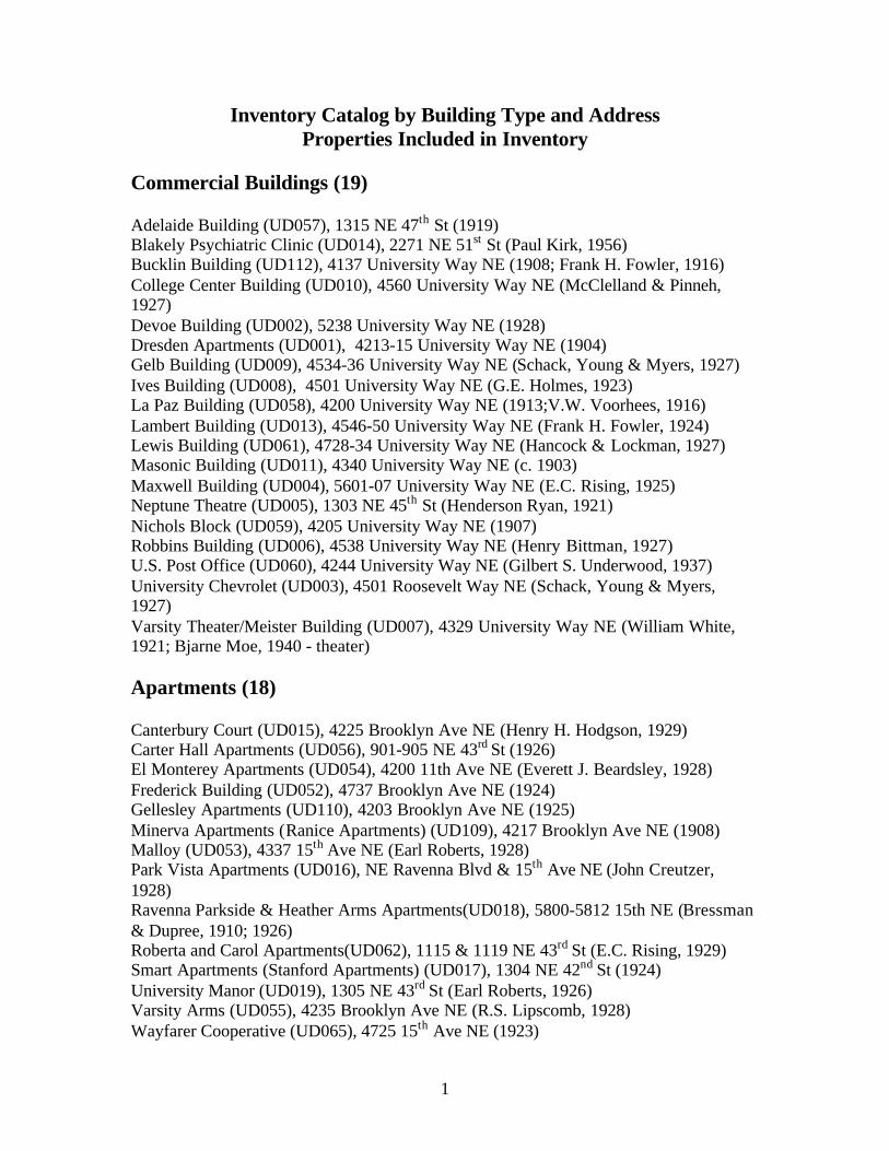
1
Inventory Catalog by Building Type and AddressProperties Included in Inventory
Commercial Buildings (19)
Adelaide Building (UD057), 1315 NE 47th St (1919)Blakely Psychiatric Clinic (UD014), 2271 NE 51st St (Paul Kirk, 1956)Bucklin Building (UD112), 4137 University Way NE (1908; Frank H. Fowler, 1916)College Center Building (UD010), 4560 University Way NE (McClelland & Pinneh,1927)Devoe Building (UD002), 5238 University Way NE (1928)Dresden Apartments (UD001), 4213-15 University Way NE (1904)Gelb Building (UD009), 4534-36 University Way NE (Schack, Young & Myers, 1927)Ives Building (UD008), 4501 University Way NE (G.E. Holmes, 1923)La Paz Building (UD058), 4200 University Way NE (1913;V.W. Voorhees, 1916)Lambert Building (UD013), 4546-50 University Way NE (Frank H. Fowler, 1924)Lewis Building (UD061), 4728-34 University Way NE (Hancock & Lockman, 1927)Masonic Building (UD011), 4340 University Way NE (c. 1903)Maxwell Building (UD004), 5601-07 University Way NE (E.C. Rising, 1925)Neptune Theatre (UD005), 1303 NE 45th St (Henderson Ryan, 1921)Nichols Block (UD059), 4205 University Way NE (1907)Robbins Building (UD006), 4538 University Way NE (Henry Bittman, 1927)U.S. Post Office (UD060), 4244 University Way NE (Gilbert S. Underwood, 1937)University Chevrolet (UD003), 4501 Roosevelt Way NE (Schack, Young & Myers,1927)Varsity Theater/Meister Building (UD007), 4329 University Way NE (William White,1921; Bjarne Moe, 1940 - theater)
Apartments (18)
Canterbury Court (UD015), 4225 Brooklyn Ave NE (Henry H. Hodgson, 1929)Carter Hall Apartments (UD056), 901-905 NE 43rd St (1926)El Monterey Apartments (UD054), 4200 11th Ave NE (Everett J. Beardsley, 1928)Frederick Building (UD052), 4737 Brooklyn Ave NE (1924)Gellesley Apartments (UD110), 4203 Brooklyn Ave NE (1925)Minerva Apartments (Ranice Apartments) (UD109), 4217 Brooklyn Ave NE (1908)Malloy (UD053), 4337 15th Ave NE (Earl Roberts, 1928)Park Vista Apartments (UD016), NE Ravenna Blvd & 15th Ave NE (John Creutzer,1928)Ravenna Parkside & Heather Arms Apartments(UD018), 5800-5812 15th NE (Bressman& Dupree, 1910; 1926)Roberta and Carol Apartments(UD062), 1115 & 1119 NE 43rd St (E.C. Rising, 1929)Smart Apartments (Stanford Apartments) (UD017), 1304 NE 42nd St (1924)University Manor (UD019), 1305 NE 43rd St (Earl Roberts, 1926)Varsity Arms (UD055), 4235 Brooklyn Ave NE (R.S. Lipscomb, 1928)Wayfarer Cooperative (UD065), 4725 15th Ave NE (1923)

2
Wilsonian (UD064), 4700-10 University Way (Frank Fowler, 1923)(UD124) 711 NE 43rd St (Frederick Anhalt, 1928)(UD063) 2300-2308 NE 54th St (Robert H. Ross, 1954)
Fraternity and Sorority Buildings (16)
Alpha Chi Omega (now Alpha Xi Delta Sorority) (UD121), 1616 NE 50th St (Howard H.Riley, 1926)Alpha Delta Phi Fraternity (Austin House) (UD 040), 2106 NE 47th St (Edwin J. Ivey,1928)Alpha Tau Omega (now Delta Kappa Epsilon Fraternity) (UD041), 1800 NE 47th St(Lionel Pries, 1929)Chi Psi Fraternity (UD035), 4600 22nd Ave NE (Stuart & Wheatley, 1927)Delta Kappa Epsilon (now Tau Kappa Epsilon Fraternity) (UD033), 4520 21st Ave NE(Harlan Thomas, 1914)Phi Gamma Delta Fraternity (UD032), 4503 17th Ave NE (Mellor & Meigs with J. ListerHolmes, 1929)Psi Upsilon Fraternity (UD078), 1818 NE 47th St (Bebb & Gould, 1924)Sigma Chi Fraternity (UD123), 4505 18th Ave NE (J. Lister Holmes, 1928)Sigma Kappa Sorority (UD034), 4510 22nd Ave NE (Joseph L. Skoog, 1930)Sigma Nu Fraternity (UD027), 1616 NE 47th St (Ellsworth Storey, 1916)Theta Xi Fraternity (UD042), 4522 18th Ave NE (Schack, Young & Myers, 1926)Zeta Psi Fraternity (UD085), 4703 21st Ave NE (Arthur Loveless, 1927)Zeta Tau Alpha Sorority (UD122), 4731 18th Ave NE (Arthur Loveless, 1928)Theta Chi Fraternity (UD118), 4535 17th Ave NE (Walter Lund, 1931)Former Kappa Sigma Fraternity (UD120), 5004 17th Ave NE (Charles Haynes, 1914)Sigma Alpha Epsilon Fraternity (UD119), 4506 17th Ave NE (Stuart & Wheatley, 1925)
Houses (70)
4216 7th Avenue NE (UD075) (1901)4720 7th Ave NE (UD073) (1911)5338 7th Ave NE (UD101) 19185031 8th Ave NE (UD103) 19094719 9th Ave NE (UD069) (1911)4730 9th Ave NE (UD102) (1908)4548 11th Ave NE (UD072) (1904)4716 11th Ave NE (UD104) (1911)4106 12th Ave NE (UD023) (c. 1891)4119 12th Ave NE (UD067) (1907)4238 12th Avenue NE (UD105)(1908)5047 12th Ave NE (UD086) (1910)5203 12th Ave NE (UD083)(Okey Gregg, 1910)5217 12th Ave NE (UD030) (1906)5243 12th Ave NE (UD116) (1924)5251 12th Ave NE (UD098) (c. 1907)
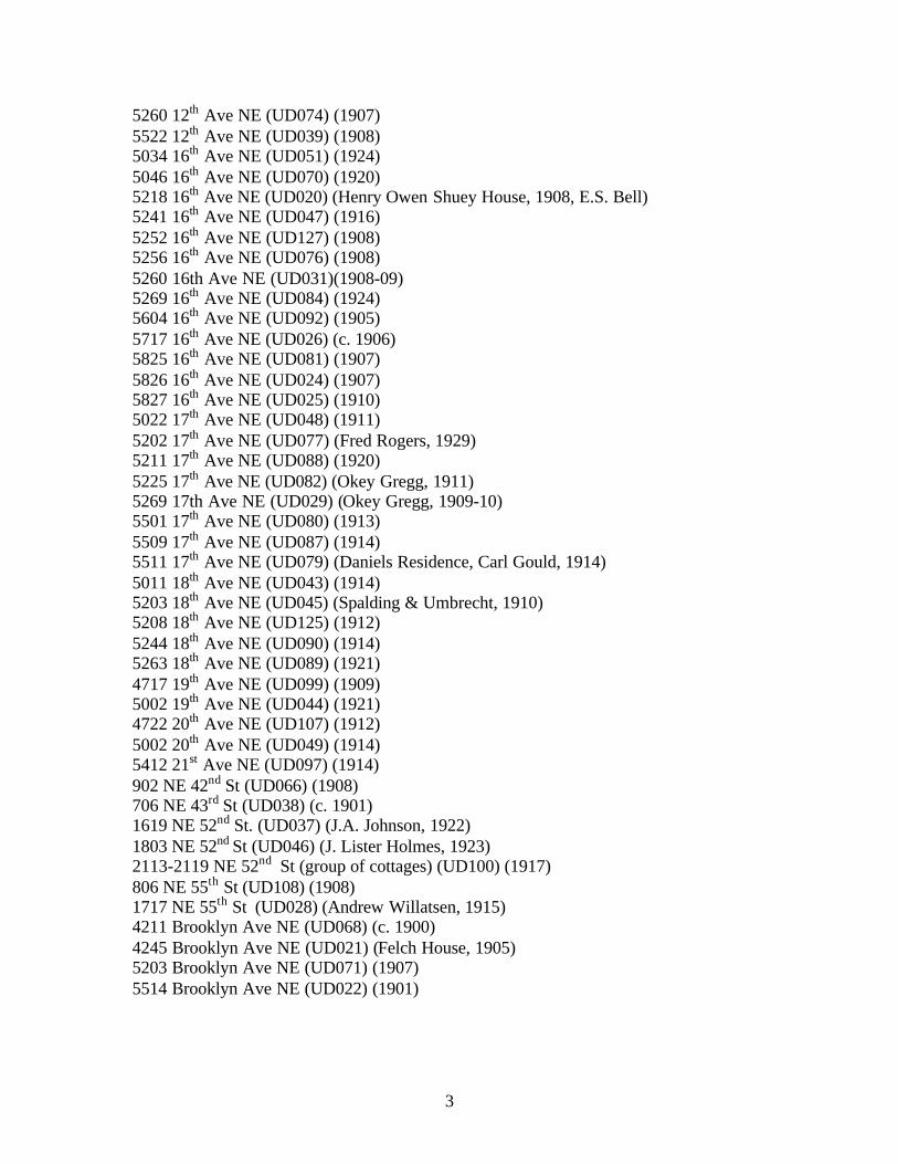
3
5260 12th Ave NE (UD074) (1907)5522 12th Ave NE (UD039) (1908)5034 16th Ave NE (UD051) (1924)5046 16th Ave NE (UD070) (1920)5218 16th Ave NE (UD020) (Henry Owen Shuey House, 1908, E.S. Bell)5241 16th Ave NE (UD047) (1916)5252 16th Ave NE (UD127) (1908)5256 16th Ave NE (UD076) (1908)5260 16th Ave NE (UD031)(1908-09)5269 16th Ave NE (UD084) (1924)5604 16th Ave NE (UD092) (1905)5717 16th Ave NE (UD026) (c. 1906)5825 16th Ave NE (UD081) (1907)5826 16th Ave NE (UD024) (1907)5827 16th Ave NE (UD025) (1910)5022 17th Ave NE (UD048) (1911)5202 17th Ave NE (UD077) (Fred Rogers, 1929)5211 17th Ave NE (UD088) (1920)5225 17th Ave NE (UD082) (Okey Gregg, 1911)5269 17th Ave NE (UD029) (Okey Gregg, 1909-10)5501 17th Ave NE (UD080) (1913)5509 17th Ave NE (UD087) (1914)5511 17th Ave NE (UD079) (Daniels Residence, Carl Gould, 1914)5011 18th Ave NE (UD043) (1914)5203 18th Ave NE (UD045) (Spalding & Umbrecht, 1910)5208 18th Ave NE (UD125) (1912)5244 18th Ave NE (UD090) (1914)5263 18th Ave NE (UD089) (1921)4717 19th Ave NE (UD099) (1909)5002 19th Ave NE (UD044) (1921)4722 20th Ave NE (UD107) (1912)5002 20th Ave NE (UD049) (1914)5412 21st Ave NE (UD097) (1914)902 NE 42nd St (UD066) (1908)706 NE 43rd St (UD038) (c. 1901)1619 NE 52nd St. (UD037) (J.A. Johnson, 1922)1803 NE 52nd St (UD046) (J. Lister Holmes, 1923)2113-2119 NE 52nd St (group of cottages) (UD100) (1917)806 NE 55th St (UD108) (1908)1717 NE 55th St (UD028) (Andrew Willatsen, 1915)4211 Brooklyn Ave NE (UD068) (c. 1900)4245 Brooklyn Ave NE (UD021) (Felch House, 1905)5203 Brooklyn Ave NE (UD071) (1907)5514 Brooklyn Ave NE (UD022) (1901)

4
Brooklyn Group (UD050) - 5239 Brooklyn Ave NE (1910), 5247 Brooklyn Ave NE(1904), 5252 Brooklyn Ave NE (1907), 5257 Brooklyn Ave NE (1903) (group of similarhouses with gable detail)Candy Cane Lane Group (UD096) - 5607 Park Rd NE (1929), 2110 NE Park Rd (1924),2120 NE Park Rd (1929), 2128 NE Park Rd (1926), 2012 NE Ravenna Blvd (1929), 2016NE Ravenna Blvd (1928), 2100 NE Ravenna Blvd (1923)Ravenna Ave Cottages (UD113) - 5002, 5006, 5010, 5016, 5020 Ravenna Ave NE5200-5208 Ravenna Ave NE (cottage group) (UD111)5411 Ravenna Ave NE (UD091) (Victor Steinbrueck, 1950)1021 NE Ravenna Blvd (UD095) (1916)1620 NE Ravenna Blvd (UD115) (1920)1711 NE Ravenna Blvd (UD094) (1908)1719 NE Ravenna Blvd (UD093) (1907)1802 NE Ravenna Blvd (UD036) (1909)1857 NE Ravenna Blvd (former substation) (UD117) (c.1924; 1952)
Churches (3)
University Baptist Church (UD106), 4554 12th Ave NE (Schack, Young & Myers, 1925;Frederick V. Lockman, 1937)Christ Episcopal Church (UD126), 4548 Brooklyn Ave NE (William R. Grant, 1914)Seventh Day Adventist Church (UD012), 4550 11th Ave NE (1905)