United States Coast Guard Auxiliary · 2018-05-29 · Conventional Direction of Buoyage – 19 Port...
57
Navigation Systems Division - Prevention, Accuracy, Credibility, Professionalism and Service to the Coast Guard United States Coast Guard Auxiliary National Short Range Aids to Navigation Training Guide (29 OCT 2013)
Transcript of United States Coast Guard Auxiliary · 2018-05-29 · Conventional Direction of Buoyage – 19 Port...

Navigation Systems Division - Prevention, Accuracy, Credibility, Professionalism
and Service to the Coast Guard
United States Coast Guard Auxiliary
National Short Range Aids to Navigation
Training Guide
(29 OCT 2013)
USCG Auxiliary National Short Range Aids to Navigation Training Guide
Page 2 of 56
Last Updated 29 Oct 2013
Table of Contents
Introduction to Short Range Aids to Navigation - 3 Objectives of this Guide– 3 Tools needed for checking Aids to Navigation - 4 Binoculars - 4 Time Piece - 4 GPS - 4 Light List - 5 LNM – Local Notice to Mariners - 5 Coast Pilot - 5 Chart No. 1 - 6 Nautical and River Charts - 6 ANSC/NS-7054 Aid to Navigation Report – 6. Pencil - 6 Plotter - 6 Digital Camera – 7 Special Developments - 7 Calculator - 7
References – 7 The IALA System of Aids to Navigation - 8
Conventional Direction of Buoyage - 8 Lateral System as seen when entering from seaward - 8
Port Side Marks – 9 Starboard Side Marks - 9
Preferred Channel Marks - 10 Junction – 11 Bifurcation – 11 Crossing – 11 Wreck Marks - 12 Beacons – 12 Buoyant Beacons - 12 Buoys - 13
Aids to Navigation having no lateral significance - 13 Safe Water Marks - 13 Isolated Danger Marks - 13 Special Marks - 14 Information and Regulatory Marks – 14 Mooring Buoys - 15 Major Lights - 16
Coastal Lights - 16 Seacoast Lights - 16 Inland Major Lights - 16 Discrepancies on a major light - 16
Directional or Sector Lights - 16 Fog Detector - 17 Discrepancies on a Fog Detector - 17 RACON - 17 Discrepancies on a RACON - 17 Sound Signal – 18 Discrepancies on a Sound Signal - 18
The Western River System – 19
Conventional Direction of Buoyage – 19 Port Side or Right Descending Bank Buoys – 20 Stbd Side or Left Descending Bank Buoys – 20
Preferred Channel Marks - 21 The Intracoastal Waterway System – ICW - 22 ICW Markings - 22 Dual Purpose Aids - 22
Marking of Coaxial Waterways - 22
Variations on the Direction of Buoyage - 24 The Uniform State Waterway Marking System - 25 Inland Waters Obstruction Mark - 25
Cardinal Marks - 25
Lanterns - 26 Solar LED Lanterns - 26
Light Characteristics – 26 Discrepancies on Lights - 27
Ranges - 28 Discrepancies on Ranges –28 Extra Pre-underway electronic measuring equipment checks for Navigation Systems (NS) Patrols – 29 Guidelines for checking an Aid to Navigation - 31 Guidelines for taking a Fix - 33 Guidelines for taking a Depth Reading – 34 Accuracy Statement – 35 Suggested Boat Crew Assignments - 35
Short Range Aids to Navigation Discrepancies - 36
Location Discrepancies - 36 Condition Discrepancies - 36 Lighting Discrepancies – 36 Dayboard Discrepancies – 37 Other Discrepancies – 37 Documentation & Specification Checks – 37
Important Points to Remember - 37 Guide for reporting Navigation Systems Activity to AUXDATA - 39 Private Aids to Navigation – 41 Federal Regulations 33 CFR, Part 66 - 41 Fish Farms, Fish Stakes and Fish Traps – 48
Fish Farms – 48 Fish Havens – 49 Fish Stakes – 50 Fish Trap Areas – 50
How to Take and Report Quality Digital Photographs as Supporting Documentation - 51 List of Acronyms and Terms – 53 LAT/LONG Conversion Table – 55 INDEX – 56
Figures 1 – Three-line GPS Screen – 4 2 – Conventional Direction of Buoyage - 8 3 – Port Side Odd Numbered Aids - 9 4 – Starboard Side Even Numbered Aids – 9 5 – Preferred Channel Aids – 10 6 – Junction, Bifurcation, and Crossing Patterns - 12 7 – Safe Water Marks - 13 8 – Isolated Danger Marks - 13 9 – Special Marks - 14 10 – Information and Regulatory Marks – 15 11 – Western Rivers – Port Side/Right Desd. Bank - 19 12 – Western Rivers – Starboard Side /Left Desd Bank - 19 13 – Western Rivers – Preferred Channel Marks - 20 14 – Samples of ICW marked Aids - 22 15 – Coaxial Waterway - 23 16 – Var. on the direction of Conventional Buoyage - 24 17 – Inland (State) Waters Obstruction Mark - 25 18 – Cardinal Marks System - 25 19 – The Elements of a Navigational Lantern - 26 20 – Solar LED Lanterns - 26 21 – Ranges - 28 22 - Pre-Underway Check List for ATON/CU Patrols. - 30

USCG Auxiliary National Short Range Aids to Navigation Training Guide
Page 3 of 56
Last Updated 29 Oct 2013
Introduction to Short Range Aids to Navigation
One of the primary responsibilities of the Auxiliary
National Short Range Aid to Navigation Program is
the reporting of discrepancies observed on both
Federal Aids to Navigation (ATONs) and Private
Aids to Navigation (PATONs). It is a partnership
between the Coast Guard and the Auxiliary that
focuses on assisting the Coast Guard in backwater
and remote areas where the Coast Guard doesn’t
transit in the normal course of daily operations, as
well as the more traveled waterways of the country.
This “National Short Range Aids to
Navigation Training Guide” explains the
guidelines for checking aids and for reporting
observations of any discrepancies to the Coast Guard
units in charge of the maintenance of those aids.
Auxiliarists report to the Coast Guard only those
discrepancies that they observe on aids. Federal aids
found “watching properly” are normally not reported
to the Coast Guard. The exception is when a Coast
Guard unit or entity specifically requests that a
particular aid or aids be observed. In addition,
Auxiliarists are able to take credit in AUXDATA for
all the aids to navigation (ATON) verifications when
the Auxiliarist has been directed by the CG to
perform ATON checks. Review the guidelines for
checking a Federal aid on page 32 in this training
guide.
Conduct all of your Navigation Systems (NS)
activities in a partnership mode with the local CG
ANT, Sector or other entity that is responsible for
managing the aids to navigation in your area.
Objectives of this Guide
To acquire a generalized knowledge of the
specifications for a Short Range Aids to
Navigation.
Note: The specific report routing path for an ANSC
or NS-7054 – Aids to Navigation Report is per
your District’s policy or standard operating
procedures (SOP). It is important to not lose sight of
the primary purpose of this activity, which is always
to get the discrepancy report to the Coast Guard unit
that manages the aid as quickly as possible.
Processing P/ATON reports through multi-levels of
Auxiliary hierarchy often defeats this objective.
However, the use of electronic means to prepare and
transmit the reports can expedite the reporting
process.
To develop a familiarity with all of the potential
discrepancies that may be found on a Short
Range Aids to Navigation (ATON and
PATON).
To become familiar with the Auxiliary guidelines
for checking Short Range Aids to Navigation
(ATON and PATON) properly. This includes
the guidelines for taking and reporting fixes and
depths.
To provide members with an understanding of
the high quality standards necessary for operating
any electronic equipment used for taking
measurements for the ATON and PATON
program.
To gain an appreciation for the importance of
reporting all NS activity to AUXDATA for time
and activity credits.

USCG Auxiliary National Short Range Aids to Navigation Training Guide
Page 4 of 56
Last Updated 29 Oct 2013
Tools needed for checking Aids to Navigation The following tools are needed for checking an aid to navigation properly. Usually, this equipment is found aboard
an operational facility (OPFAC). However, many Auxiliarists, who participate in the Navigation System’s
Programs, often carry a navigation kit that contains their personal navigation equipment. For a successful aid
checking experience, you have to have the right navigational tools that are operating accurately, and are available
when needed. By including this equipment as part of your pre-underway equipment check, you are helping to
guarantee a successful patrol. Pre-calibrate each electronic navigational instrument to ensure that it is operating
accurately and record your findings before you get underway. Make it a standard practice to record the test results
on a Pre-underway checklist for Navigation Systems Patrols, which is included in this training guide on
page 31. It is also available on the Navigation Systems Division Web Site. You will need the data later as part of a
discrepancy report to the Coast Guard. Links to Aids to Navigation publications and catalogs can be found on the
Navigation Systems Division Web Site.
Binoculars - Size 7 x 50 are preferred. Binoculars are used to view aids or objects
that maybe located in area where it is unsafe to operate an OPFAC in order to get a
close-up view of potential discrepancies. Many small, inexpensive and powerful
binoculars or monoculars are commercially available and will make a perfect addition to
your navigation kit.
Time Piece - A watch or stopwatch is a useful tool for timing the period of an aid’s light.
Any good wristwatch also satisfies this operational need. Your GPS set can provide very
accurate date and time information. Report the time when taking fixes and depths
alongside aids. Set up a GPS screen to show time, Lat/Long, and EPE (Estimated Position
Error). The screen set up in Figure 1 below is a very handy reference tool for collecting data
when locating objects on-scene.
Figure 1 – Three-line GPS Screen
Latitude Longitude 42–36-23.50 N 070-23-30.01 W
12.4 ft EPE
Time: 14:45
GPS - A GPS set with WAAS (Wide Area Augmentation System) can provide location data
(Fix) that can be accurate to within 8 to 10 feet. WAAS usually comes as a standard feature on
new GPS sets. Ten feet is inside the beam (width) of the ordinary OPFAC. If you use one of
the fine hand-held GPS models that are currently available, be sure to buy a power cable that
plugs into your vessel’s 12v power. Also, add spare batteries for your GPS to your navigation
kit. Consider purchasing a hand-held GPS mounting bracket and attaching your hand-held GPS
to a plotting board or large clipboard. The clipboard can hold your GPS set while underway and
keep your reference documents from blowing away. Good organizational practices speed up the
on-scene observations and recording time.

USCG Auxiliary National Short Range Aids to Navigation Training Guide
Page 5 of 56
Last Updated 29 Oct 2013
Light List - Contains a listing and LAT/LONG of most of the aids to navigation in
your AOR. Some federal and private aids, for example some buoys in the Western
River system or Class III PATONs, may not be listed in the Light List. Different Light
List volumes are available depending on your geographic location. The Light List for
your region is available on the USCG Navigation Center website at
http://www.navcen.uscg.gov/. Print out only those pages that relate to the area
where you operate your boat.
Corrections to Light Lists are published in two different places. They are available in
Weekly and Monthly formats in the Light List section on the USCG Navigation Center
website. They are also published in the Local Notice to Mariners (LNM) in the
Summary of Corrections. The full Light List document is corrected weekly and is
available on line at http://www.navcen.uscg.gov/?pageName=lightListWeeklyUpdates.
Check every on-scene observation that you perform on an aids to navigation against its
entry in the Light List. Also, validate both the observation of the aid and the entry in
the Light List to the symbols and abbreviations used to identify the aid on the NOAA
or USACE chart. Any mismatch is a reportable discrepancy to your CG unit, as
specified in your District’s procedures. Also verify the charted position of an aid to
the LAT/LONG or Mile Marker in the Light List. Charted errors provide an
opportunity for a Chart Update report to NOAA. The assigned position of a charted
aid is only changed by NOAA from data reported by the Coast Guard in the I-ATONIS
System and, subsequently, published in the Local Notice to Mariners. Corrections to
charted aids are made concurrently and may be viewed on on-line NOAA charts.
Information on submitting corrections to USACE Inland Electronic Navigation Charts
(IENC) can be found on the USACE Army Geospatial Center’s website. Links to
NOAA and USACE on-line charts are provided on the Navigation Systems Division
Web Site.
Local Notice to Mariners (LNM) - Keep your flotilla charts and other nautical publications updated to the
latest Local Notice to Mariners. The LNM is available on-line on a weekly basis and is published on the Coast
Guard’s Navigation Center web site. Prudent mariners update their nautical chart(s), Light List and Coast Pilot
before every NS patrol. Your LNMs are available on the USCG Navigation Center website at
http://www.navcen.uscg.gov/. On-line NOAA charts are updated to data published in the LNM. To repeat, note
that Light Lists that are available on-line are corrected weekly on-line.
Coast Pilots - Contain information that is not easily included on the nautical chart. Links
to this publication are available on-line at the NOAA Office of Coast Survey website at
http://www.nauticalcharts.noaa.gov/. Print out only those pages that pertain to your area
of operation (AOR) and keep them in your navigation kit. It is always a good practice to
review the Coast Pilot data while you are performing ATON activity and when you are
planning a patrol. Submissions of Chart Update and Small Craft Facility reports to NOAA
are used to update Coast Pilots. Reference the “NS Nautical Chart Update Training Guide”
for specific guidelines for preparing and reporting Coast Pilot corrections.

USCG Auxiliary National Short Range Aids to Navigation Training Guide
Page 6 of 56
Last Updated 29 Oct 2013
Chart No. 1 - Contains every abbreviation and symbol used on a nautical chart and
should be part of the navigation kit of every serious navigator. This publication is
available online at the NOAA Office of Coast Survey website at
http://www.nauticalcharts.noaa.gov/. If you desire to purchase a hard copy, every
authorized marine chart dealer should stock a copy or you can purchase a copy from the
major on-line book dealers. Ensure that you purchase the most recent edition.
Nautical or River Charts - Every OPFAC should be using the latest
nautical or river chart that is updated to the latest Local Notice to Mariners
(LNM).
NOAA Nautical Charts are available online at
http://www.nauticalcharts.noaa.gov/. USACE River Charts are
available online at http://www2.mvr.usace.army.mil/NIC2/. LNM
corrections for every nautical chart are available on the USCG Navigation
Center website at http://www.navcen.uscg.gov/. Keep copies of the
current nautical or river charts in your personal Navigation Kit.
While coxswains and OPFAC owners are responsible for maintaining up-to-date nautical charts on their OPFAC,
Flotilla Staff officers should offer their chart correcting skills and services to the OPFAC owners in the flotilla as a
regular part of their job.
Members who submit chart updates to NOAA that result in the destruction of their chart can order and receive a
free replacement chart from NOAA. The Flotilla Chart Updating activity should be managed by the FSO-NS.
ANSC/NS-7054 - Aids to Navigation Report – This report is available on the Navigation Systems
Division Web Site. Print it out and use it for recording on-scene observations. Keep adequate copies of these
forms in your navigation kit.
Pencil - An automatic pencil using 0.5 HB lead with an eraser is ideal. It is always sharp.
Include extra pencils, leads and erasers in your personal navigation kit. If you decide to use
regular wooden pencils, add a small pencil sharpener to your kit.
Plotter – A paraglide plotter is a practical plotting instrument to use on a small
boat. Be sure your plotter has wheels to roll it easily on a chart without losing the
course angle. Prudent mariners always plot their intended courses on their
nautical chart before they get underway. Modern mariners take the extra step to
establish waypoints and routes in their GPS, and schedule their aid verifications
and checks along the route. This practice not only speeds up the Navigation
Systems patrol but also saves much time and fuel while minimizing risk. It also
provides a great opportunity to teach navigation to the crew between planned
activity events. This practice also provides an added safety factor for your return
trip in the event of deteriorating weather. There are many different plotters
available.

USCG Auxiliary National Short Range Aids to Navigation Training Guide
Page 7 of 56
Last Updated 29 Oct 2013
Digital Camera – A digital camera is a fantastic tool for communicating
discrepancies to the Coast Guard and other agencies. Purchase a computer cable with
your camera to be able to download your pictures to your PC so that they can be e-
mailed to the appropriate Coast Guard unit or entity. One picture of a discrepancy is
often worth a thousand words. This phrase may sound trite but it is very true. Clear
photos of a discrepancy greatly increase the credibility of your discrepancy reports
with the Coast Guard and generate quick action. Be sure the camera battery is fully
charged and/or have a charging cable with you.
Record the number that is assigned to the picture by the camera as you take the
photos. This practice eliminates any confusion about what has been photographed
when you are finalizing your report to the Coast Guard or NOAA. Read the
guidelines for taking and reporting Digital Photos on page 53.
Special Developments - Some Auxiliarists have fabricated many unique tools and instruments. Some
examples are sounding poles for shallow depths, chain and wire drags, tools for measuring the angle of leaning
aids, and plotting boards fitted with mounting devices for handheld GPS sets. Also, there are electronic
spreadsheets developed that calculate the distance an aid is off station using location (Lat/Long) and almanac data
available on your GPS. Check out the NS Vertical and Horizontal Error Calculator on the on the Navigation
Systems Division Web Site. The use of GPS sets with chart plotters and computerized charts facilitate the checking
of whether an aid is on station.
Hand Held Calculator with solar panel
Calculators - There are many calculations needed when checking and preparing aid
discrepancy reports. Add a good calculator to your navigation kit. The ideal unit
would have a solar panel and a battery system for nighttime use. You may have to get
two units. Do not forget to add spare batteries to your navigation kit.
References:
USCG Aids to Navigation Manual – Administration COMDTINST M16500.7A
Light List – COMDTPUB P16502.1
The Coast Pilot
Chart No. 1
LNM - Local Notice to Mariners
NOAA Nautical Charts
USACE River Charts

USCG Auxiliary National Short Range Aids to Navigation Training Guide
Page 8 of 56
Last Updated 29 Oct 2013
The IALA System of Aids to Navigation The U.S. Aids to Navigation System is predominantly a lateral system which is consistent with Region B
requirements of the International Association of Marine Aids to Navigation and Lighthouse Authorities (IALA-B)
Maritime Buoyage System. In Region B, the memory aid 3R rule of "Red, Right, Returning from the sea"
applies.
Exceptions exist for the U.S. possessions west of the International Date Line and south of 10 degrees north
latitude, which follow the IALA-A Aids to Navigation System. In Region A, green color aids to navigation will
be located on the right when returning from the sea.
CONVENTIONAL DIRECTION of BUOYAGE (CBD) In U.S. waters, the IALA-B system of lateral marks, with few exceptions, is arranged in geographic order known
as the conventional direction of buoyage. The memory aid "Red, Right, Returning from the sea" applies. This
means keep the red markers to the right hand side of the OPFAC when returning from seaward and when
transiting from north to south along the Atlantic Coast, from south to north and east to west along the Gulf Coast,
from south to north and east to west along the Pacific Coast, and from east to west in the Great Lakes except for
Lake Michigan which is north to south.
Figure 2 – CDB - Conventional Direction of Buoyage Graphic
THE LATERAL SYSTEM AS SEEN WHEN ENTERING FROM SEAWARD
Lateral Marks define the port and starboard sides of a channel or fairway being followed. Their most frequent
use is to mark the sides of channels. However, they may be used individually to mark obstructions located outside
of clearly defined channels. Lateral marks normally have three criteria that assist the mariner in their quick
identification – shape, color, and numbering. Lighted lateral aids use the same light color as the aid color.
Lighted aids are often made up by joining a buoy body and a structure on which the light is mounted. While this

USCG Auxiliary National Short Range Aids to Navigation Training Guide
Page 9 of 56
Last Updated 29 Oct 2013
voids the shape criterion, the light color becomes the third criteria during the nighttime and periods of reduced
visibility. Lateral aids are numbered from seaward toward the land, from the mouth of rivers upstream, and
clockwise around islands.
Lateral marks include side marks and preferred channel marks. Side marks are not always placed directly on a
channel edge and may be positioned outside the channel as indicated on charts and nautical publications.
Port Side Marks indicate the left side of channels when proceeding in the Conventional Directions of
Buoyage. They normally show as a square or can in shape, are green in color, and have odd numbering.
Beacons have green square daymarks while buoys are green cans or pillar buoys. Green lights of various
rhythms are used on port side marks.
Figure 3 - Port Side Odd Numbered Aids
Green Light Only
Flashing (2)
Flashing
Occulting
Quick Flashing
ISO
Light
Lighted Buoy
Can
Daybeacon
Note that the numbers on daymarks are the color of the aid while the numbers on buoys are white.
Starboard Side Marks indicate the right side of channels when proceeding in the conventional directions
of buoyage. They normally show as a conical or nun shape, are red in color, and have even numbering. Beacons
have triangular red daymarks while buoys are red nuns or pillar buoys. Red lights of various rhythms are used
on starboard side marks.
Figure 4 – Starboard Side Even Numbered Aids
Red Light Only
Flashing (2) Flashing
Occulting
Quick Flashing
USCG Auxiliary National Short Range Aids to Navigation Training Guide
Page 10 of 56
Last Updated 29 Oct 2013
ISO
Light
Lighted Buoy
Note that daymarks have
colored numbers.
Note that buoys have
white numbers.
Nun
Daybeacon
Note that the numbers on daymarks are the color of the aid while the numbers on buoys are white.
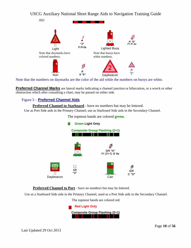
Preferred Channel Marks are lateral marks indicating a channel junction or bifurcation, or a wreck or other
obstruction which after consulting a chart, may be passed on either side.
Figure 5 – Preferred Channel Aids
Preferred Channel to Starboard - have no numbers but may be lettered.
Use as Port Side aids in the Primary Channel; use as Starboard Side aids in the Secondary Channel.
The topmost bands are colored green.
Green Light Only
Composite Group Flashing (2+1)
Daybeacon
Can
Preferred Channel to Port - have no numbers but may be lettered.
Use as a Starboard Side aids in the Primary Channel, used as a Port Side aids in the Secondary Channel.
The topmost bands are colored red.
Red Light Only
Composite Group Flashing (2+1)

USCG Auxiliary National Short Range Aids to Navigation Training Guide
Page 11 of 56
Last Updated 29 Oct 2013
Nun
Daybeacon
Junction – The point where a channel divides when proceeding to seaward. The point where a tributary
departs or splits from the main channel.
Bifurcation – The point where a channel divides when proceeding from seaward. The place where two
tributaries meet.
Crossing – The point where a main and secondary channel cross each other.
Note the placement of the preferred channel buoys in the three examples below. The main channels are labeled as
1. The secondary channels are labeled as 2.
Figure 6 – Junction and Bifurcation Patterns

USCG Auxiliary National Short Range Aids to Navigation Training Guide
Page 12 of 56
Last Updated 29 Oct 2013
Wreck Marks - 33 USC 409 requires that whenever a vessel, raft, or other
craft is wrecked and sunk in navigable waters of the United States, it must be
marked for the protection of marine traffic. The color, numbering, shape and light
characteristics of aids marking wrecks and other obstructions must conform to the
U.S. marking system and the IALA System (33 CFR Part 62) in use in the
geographical area. The use of lateral marks shall be the first consideration when
establishing a wreck marking, but the use of isolated danger marks is authorized.
Wreck Marks As Lateral Marks - If a wreck may be safely passed on one side
only, it shall be marked by a solid red or green buoy or corresponding dayboard
on a fixed structure. If a wreck may be safely passed on either side it may be
marked by a red and green horizontally banded buoy or corresponding dayboard,
the color of the uppermost band denoting the preferred side.
The light color shall be red on solid red buoys and structures with TR dayboards, green on solid green buoys and
structures with SG dayboards, and either red or green, depending on the color of the uppermost band, on
horizontally banded buoys and structures with JG or JR dayboards. The light rhythm shall be quick flashing on
solid color buoys and structures with TR and SG dayboards. The rhythm shall be composite group flashing on
horizontally banded buoys and structures with JR and JG dayboards.
Buoys and structures marking wrecks and other obstructions shall be numbered in proper sequence with other aids
to navigation in the same channel or waterway. The letters WR shall be used and shall prefix the regular number.
Wreck markings shall be located near the wreck and on the channel or seaward side of the wreck. More than one
aid may be used if necessary to minimize possible confusion as to the actual location of the wreck. The net effect
of the wreck markings shall be such that a vessel may pass the markings with safety.
In addition to the use of buoys and structures, lights and/or daymarks may be exhibited from an exposed portion
of a wreck. Racons used to mark uncharted wrecks shall be coded with the Morse letter "D".
Wreck Marks As Isolated Danger Marks - If, at the discretion of the District Commander, a lateral Aids to
Navigation is not appropriate to mark the wreck, an Isolated Danger Mark may be used. (See page 13 for Isolated
Danger Marks.)
Beacons Strictly defined, a beacon is any fixed aid to navigation. For our purposes, however, we take beacons to mean all
minor lights of relatively low candlepower and daybeacons. Fixed aids provide immobile, stable signals. Floating
aids do not. Beacons, therefore, are superior to floating aids in the signal quality that they provide to the mariner.
Beacons may be set back from the channel edge to protect them from damage. The utility of a beacon decreases as
its distance from the channel edge increases. When beacons must be set back, the distance from the channel edge
should remain constant within a waterway.
Buoyant beacons appear to be fixed, but in actuality are moored to the bottom by a sinker. They remain
afloat through use of a buoyant collar attached below the waterline. Buoyant beacons are deployed only in
unusual situations where their high cost is offset by the requirement for a reduced watch circle.
An articulated light is a vertical pipe structure supported by a submerged buoyancy chamber and attached by
a universal coupling to a weighted sinker on the seafloor. The light, allowed to move about by the universal
coupling, is not as precise as a fixed aid. However, it has a much smaller watch circle than a conventional buoy,

USCG Auxiliary National Short Range Aids to Navigation Training Guide
Page 13 of 56
Last Updated 29 Oct 2013
because the buoyancy chamber tends to force the pipe back to a vertical position when it heels over under the
effects of wind, wave, or current. Articulated lights are primarily designed to mark narrow channels with greater
precision than conventional buoys.
Buoys are unmanned, floating aids to navigation moored to the seabed. They may be lighted or unlighted.
AIDS TO NAVIGATION WITH NO LATERAL SIGNIFICANCE
Safe Water Marks indicate that there is navigable water all around
the mark. They usually mark fairways, midchannels, and offshore
approach points. Safe water marks have red and white vertical stripes,
are spherical in shape and are never numbered. When a Safe Water
mark is lighted or fitted with a sound signal, it displays a red spherical
topmark. Lighted Safe Water marks show a white light with a Morse
Code “A” rhythm.
Figure 7 - Safe Water Marks - Have no numbers but may be lettered.
White light only, shows a Morse code rhythm.
Mo(A)
RW “N" Mo(A)
RW "A"
Can
RW "N"
Isolated Danger marks are erected on, moored over, or placed immediately adjacent to an isolated danger
that may be passed on all sides by mariners. They are black with one or more broad horizontal red bands and are
fitted with a top mark of two black spheres, one above the other. When lighted, the aid displays a white light,
group flashing (two) with a period of five seconds. These aids should not be approached closely without special
caution.
Figure 8 - Isolated Danger Marks - Have no numbers but may be lettered.
White Light Only
FI(2) 5s
Lighted
Unlighted
BR "C"
USCG Auxiliary National Short Range Aids to Navigation Training Guide
Page 14 of 56
Last Updated 29 Oct 2013
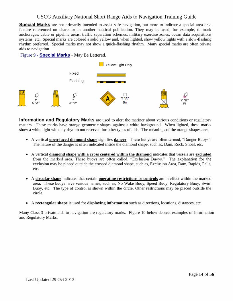
Special Marks are not primarily intended to assist safe navigation, but more to indicate a special area or a
feature referenced on charts or in another nautical publication. They may be used, for example, to mark
anchorages, cable or pipeline areas, traffic separation schemes, military exercise zones, ocean data acquisitions
systems, etc. Special marks are colored a solid yellow and, when lighted, show yellow lights with a slow-flashing
rhythm preferred. Special marks may not show a quick-flashing rhythm. Many special marks are often private
aids to navigation.
Figure 9 - Special Marks - May Be Lettered.
Yellow Light Only
Fixed
Flashing
Information and Regulatory Marks are used to alert the mariner about various conditions or regulatory
matters. These marks have orange geometric shapes against a white background. When lighted, these marks
show a white light with any rhythm not reserved for other types of aids. The meanings of the orange shapes are:
A vertical open-faced diamond shape signifies danger. These buoys are often termed, “Danger Buoys.”
The nature of the danger is often indicated inside the diamond shape, such as, Dam, Rock, Shoal, etc.
A vertical diamond shape with a cross centered within the diamond indicates that vessels are excluded
from the marked area. These buoys are often called, “Exclusion Buoys.” The explanation for the
exclusion may be placed outside the crossed diamond shape, such as, Exclusion Area, Dam, Rapids, Falls,
etc.
A circular shape indicates that certain operating restrictions or controls are in effect within the marked
area. These buoys have various names, such as, No Wake Buoy, Speed Buoy, Regulatory Buoy, Swim
Buoy, etc. The type of control is shown within the circle. Other restrictions may be placed outside the
circle.
A rectangular shape is used for displaying information such as directions, locations, distances, etc.
Many Class 3 private aids to navigation are regulatory marks. Figure 10 below depicts examples of Information
and Regulatory Marks.

USCG Auxiliary National Short Range Aids to Navigation Training Guide
Page 15 of 56
Last Updated 29 Oct 2013
Figure 10 - Information and Regulatory Marks – When lighted may display any light
rhythm not reserved for other types of aids.
NW White Light Only
Exclusion
Area
Restricted Operations
Danger
Information and Regulatory Marks are used to alert vessel operators to various warnings or
regulatory matters. Examples:
Boat Exclusion
Area
Danger
Controlled
Area
Explanation may be placed
outside the crossed diamond
shape.
The nature of danger may be
indicated inside the diamond shape,
such as rock, wreck, shoal, dam, etc.
Type of control is indicated in the
circle, such as slow, no wake,
anchoring, etc.
Information
Used to display directions,
distances, locations, etc.
Buoy used to display dangers. Buoy used to indicate local boating
regulations.
Mooring Buoys are white with a blue horizontal
band. This distinctive color scheme facilitates
identification and helps the mariner distinguish these
buoys from regular aids to navigation. When lighted,
mooring buoys display a white light with any rhythm not
reserved for other aids to navigation. Federal mooring
buoys and those privately-owner mooring buoys that are
permitted as Private Aids to Navigation, and are charted
or included in the Light List, shall be listed in I-ATONIS.
Ball-shaped mooring buoys are more common.

USCG Auxiliary National Short Range Aids to Navigation Training Guide
Page 16 of 56
Last Updated 29 Oct 2013
Major Lights are lights of moderate to high candlepower and reliability that are exhibited from
a fixed structure. They do not fall under the IALA agreement. While their signal characteristics
are largely discretionary, they will be marked to provide maximum information while avoiding
conflicts with nearby aids displaying IALA markings. The coloration of a light is often unique in
order to avoid confusion with any nearby lights. The color of the structure should allow the light
tower to clearly stand out from its background.
A major light may or may not have colored sectors with higher intensities. Major lights have an
availability standard of at least 97% and fall into two broad categories:
Coastal or seacoast lights assist vessels during coastal navigation or when making a landfall. Their
operational range should, based on local visibility conditions, supply needed navigation data at least 97% of the
time for the transition of the mariner into waters marked by the short range system.
Inland major lights are found in bays, sounds, and coastal approaches. They can serve a variety of functions
including use as a leading light, a range light, an obstruction mark, a sector light, or simply a reference mark from
which to obtain a needed visual bearing or radar range. They should have sufficient intensity so they are visible
over their usable range 90% of the nights of the year when local visibility conditions are considered.
Discrepancies on major lights.
Aid is extinguished. Most major lights are unmanned and therefore should be checked each time they
are passed. Many lights operate 24/7 and can be checked during daylight hours.
Aid has been vandalized. Most major lights are located in remote areas and, since they are
unmanned, are susceptible to vandalism.
Also, check the discrepancies related to lanterns.
Directional or Sector Lights are devices that generate two or more defined
light regions by displaying different light color characteristics. In practice,
directional lights have three sectors, usually having red and green sectors
separated by a white sector. They are used to give an indication of a vessel’s
position with respect to the center of a waterway. Because there is only one light
source, the mariner has no indication of how fast his vessel is moving across a
given sector, nor how far into a sector has his vessel moved. Directional lights are
avoided when an aid is needed to initiate a turn and the turn must be started an
appropriate distance before the intersection of the channel centerlines.
Sector lights are commonly used to provide mariners with a warning that they
are in an area where navigation may be impaired by a shoal, rock, etc. The
mariner will have to use other aids or navigational tools to determine position
relative to the danger. In practice, sector lights commonly have two sectors
(usually red and white).
Sector Lights

USCG Auxiliary National Short Range Aids to Navigation Training Guide
Page 17 of 56
Last Updated 29 Oct 2013
Fog Detector
Fog Detectors are very convenient devices for controlling sound signal operation. They
are particularly useful where a live watch could be reduced or a radio link to a remote
station could be eliminated. Fog signals are usually calibrated to energize the sound signal
when the visibility drops below 3 miles.
Discrepancy on a fog detector.
The fog detector is inoperative.
Inoperative fog signal
Signal shutting off sooner or later than advertised in the Light List
Wrong sound signal characteristic
Reduced intensity
Note on Fog Signals: Some fog signals are being updated to become “radio activated.” During times of
reduced visibility, mariners are requested to tune their VHF-FM radio to a predetermined channel. The mariner can
then activate the fog signal for a specified time period (minutes) by keying their VHF radio’s microphone,
consecutively, a prescribed number of times, while on a specified VHF radio channel. Do not report such signals as
“inoperative.” The ATON program office (CG-NAV-1) would like the Auxiliary Aid Verifier to test the radio
activation of these Mariner Radio Activated Sound Signals (MRASS) and to report any discrepancies (inoperative
signal, signal shutting off sooner or later than advertised in the Light List, wrong sound signal characteristic,
reduced intensity, etc.) There is no harm in testing the signal. The auxiliarists should be careful not to get too close
to an operating fog signal. Hearing damage can occur. Many Fog Signals on bridges will be classified as Class I
Private Aids.
A RACON is a radar transponder, which produces a coded response, or radar paint,
when triggered by a surface search radar signal. They are
normally operated in the frequency ranges of the X-band and S-
band marine radars. RACONs provide radar enhancement, help
improve aid identification, and help during the transition from
ocean to inland navigation. This is accomplished by the
placement of a RACON: On a prominent point of land that allows the mariner to
make a positive identification of the point for a landfall.
On an aid to distinguish the aid from other aids and vessels where many
echoes appear on the radar screen.
Temporarily, on an aid that marks a new danger.
RACONs are coded with Morse-code letters that begin with a dash and contain no
more than four elements. The code usually reflects letters that are consistent with the
name of the location. The letter “D” is reserved for RACONs marking new, uncharted
dangers.
RACON
Discrepancies on a RACON:
The aid’s RACON is off the air.
The aid’s RACON is emitting improper characteristics per the Light List.
RACONs on Bridges - RACONs are often used to mark the center of the navigable channel on bridges
that service large vessels. Often, these aids are Private Aids to Navigation. Three separate discrepancy
reports may be required. Make a report as a PATON discrepancy, as a Bridge discrepancy and as a special
report to the Sector.

USCG Auxiliary National Short Range Aids to Navigation Training Guide
Page 18 of 56
Last Updated 29 Oct 2013
A Sound Signal (fog signal) is a device which transmits sound intended to
provide information to mariners during periods of low visibility and foul weather.
The term also applies to the sound emitted by the device. Due to the inability of
the human ear to accurately judge the direction of a sound source, these signals
are limited to only one general use—the signal serves to warn mariners of the
proximity of an obstruction.
Although sound signals are valuable, mariners should not implicitly rely on them
when navigating. Instead, they should be considered supplements to radar and
radio-navigation aids during reduced visibility navigation.
Wave actuated signals are used where environmental conditions permit. When
two or more channels are located in the same general area, such as near a junction
or bifurcation, a different signal type is used for each waterway to assist in
identification. Historically, mid-channels, fairways, and approaches have been
marked with whistles. They can also be marked with an electronic horn.
The Coast Guard is discouraging the use of sound signals in lateral situations such
as placing gongs to port and bells to starboard and is discouraging mariners from
relying implicitly on sound signals.
Discrepancies on a sound signal:
The sound signal, either a bell, a gong, a horn, or a whistle,
is inoperative. Sound signals may be electrically operated or wave
actuated.
The tappers on a gong or a bell are missing.
The sounding device is missing.
The fog horn is inoperative
Sound
Fog Signals
Other ranges, sector lights, and crossing marks do not fall under the IALA agreement. While their signal
characteristics are largely discretionary, these aids are marked to provide maximum information to the mariner
while avoiding conflicts with nearby aids displaying IALA markings.
USCG Auxiliary National Short Range Aids to Navigation Training Guide
Page 19 of 56
Last Updated 29 Oct 2013
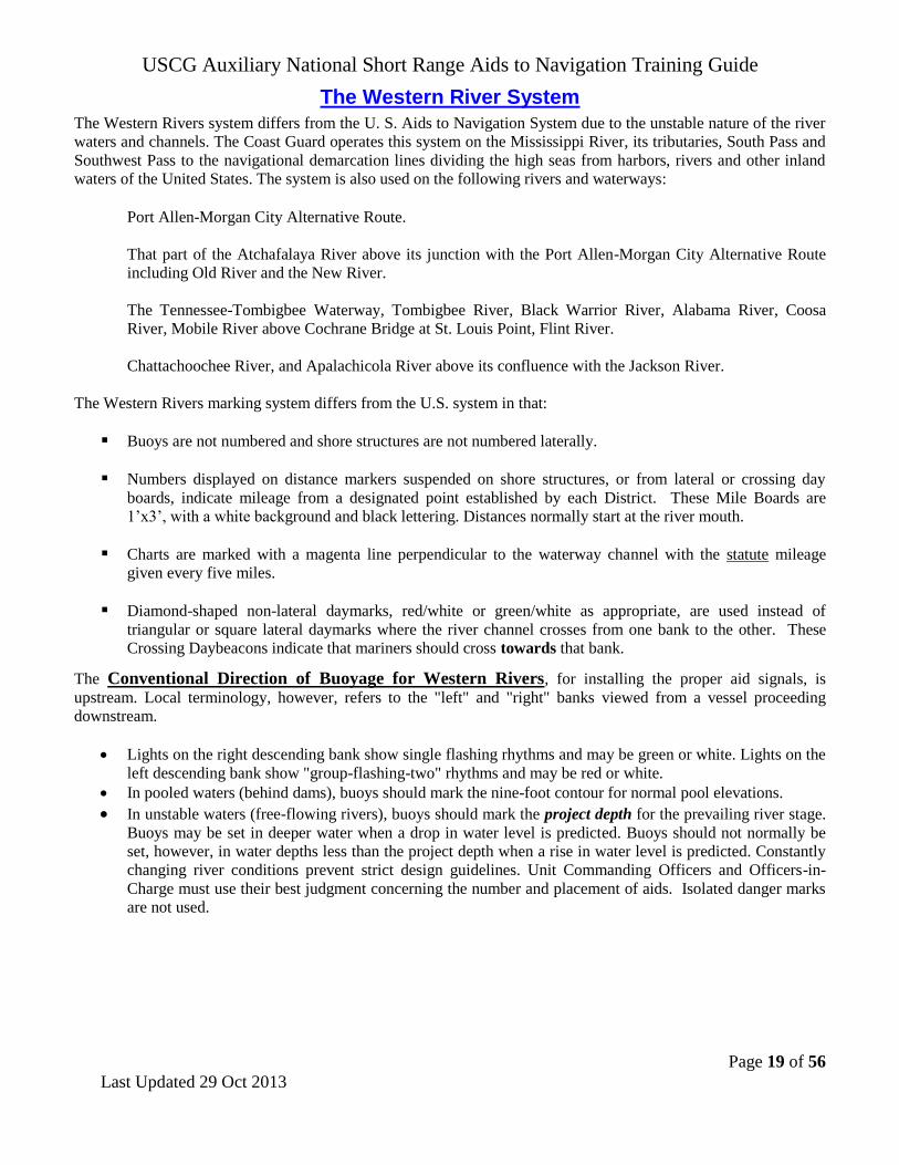
The Western River System
The Western Rivers system differs from the U. S. Aids to Navigation System due to the unstable nature of the river
waters and channels. The Coast Guard operates this system on the Mississippi River, its tributaries, South Pass and
Southwest Pass to the navigational demarcation lines dividing the high seas from harbors, rivers and other inland
waters of the United States. The system is also used on the following rivers and waterways:
Port Allen-Morgan City Alternative Route.
That part of the Atchafalaya River above its junction with the Port Allen-Morgan City Alternative Route
including Old River and the New River.
The Tennessee-Tombigbee Waterway, Tombigbee River, Black Warrior River, Alabama River, Coosa
River, Mobile River above Cochrane Bridge at St. Louis Point, Flint River.
Chattachoochee River, and Apalachicola River above its confluence with the Jackson River.
The Western Rivers marking system differs from the U.S. system in that:
Buoys are not numbered and shore structures are not numbered laterally.
Numbers displayed on distance markers suspended on shore structures, or from lateral or crossing day
boards, indicate mileage from a designated point established by each District. These Mile Boards are
1’x3’, with a white background and black lettering. Distances normally start at the river mouth.
Charts are marked with a magenta line perpendicular to the waterway channel with the statute mileage
given every five miles.
Diamond-shaped non-lateral daymarks, red/white or green/white as appropriate, are used instead of
triangular or square lateral daymarks where the river channel crosses from one bank to the other. These
Crossing Daybeacons indicate that mariners should cross towards that bank.
The Conventional Direction of Buoyage for Western Rivers, for installing the proper aid signals, is
upstream. Local terminology, however, refers to the "left" and "right" banks viewed from a vessel proceeding
downstream.
Lights on the right descending bank show single flashing rhythms and may be green or white. Lights on the
left descending bank show "group-flashing-two" rhythms and may be red or white.
In pooled waters (behind dams), buoys should mark the nine-foot contour for normal pool elevations.
In unstable waters (free-flowing rivers), buoys should mark the project depth for the prevailing river stage.
Buoys may be set in deeper water when a drop in water level is predicted. Buoys should not normally be
set, however, in water depths less than the project depth when a rise in water level is predicted. Constantly
changing river conditions prevent strict design guidelines. Unit Commanding Officers and Officers-in-
Charge must use their best judgment concerning the number and placement of aids. Isolated danger marks
are not used.

USCG Auxiliary National Short Range Aids to Navigation Training Guide
Page 20 of 56
Last Updated 29 Oct 2013
Figure 11 – Western Rivers - Port Side or Right Descending Bank
Green or White Lights
Flashing
ISO
Center
Lighted Buoy
Can
Passing Daybeacon
Crossing Daybeacon
May Be Lighted
Statute Mile Board (Marker)
Figure 12 – Western Rivers - Starboard Side or Left Descending Bank
Red or White Lights Flashing
ISO
Light
Lighted Buoy
Nun
Passing Daybeacon
Crossing
Daybeacon
May Be Lighted
Statute Mile Board or Distance Marker
USCG Auxiliary National Short Range Aids to Navigation Training Guide
Page 21 of 56
Last Updated 29 Oct 2013
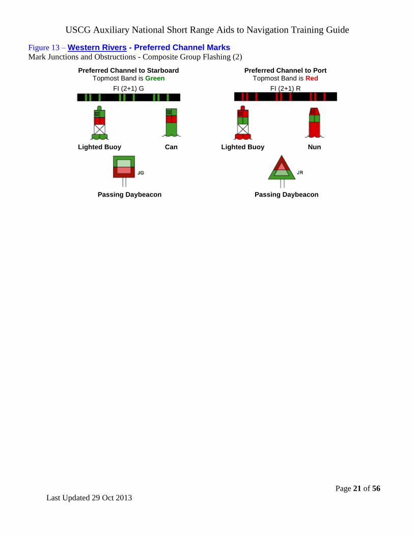
Figure 13 – Western Rivers - Preferred Channel Marks Mark Junctions and Obstructions - Composite Group Flashing (2)
Preferred Channel to Starboard Topmost Band is Green
Preferred Channel to Port Topmost Band is Red
FI (2+1) G
FI (2+1) R
Lighted Buoy Can Lighted Buoy Nun
Passing Daybeacon Passing Daybeacon

USCG Auxiliary National Short Range Aids to Navigation Training Guide
Page 22 of 56
Last Updated 29 Oct 2013
The Intracoastal Waterway System – ICW The ICW variation of the U.S. Marking System is employed along the Atlantic and Gulf Intracoastal Waterways. It
differs from the standard U.S. Marking System by displaying distinctive yellow bands, triangles, or squares to
signify ICW significance and distinguish them from other aids marking other waters. In addition to the
conventional signals, aids marking the ICW differ from the U.S. Aids to Navigation System in that:
ICW aids display a distinctive yellow symbol according to aid type and function. Distance Markers may be
used. The distance indicated is from a designated point established by each district.
ICW Markings. Yellow symbols indicate that an aid marks the Conventional Direction of Buoyage on the
Intracoastal Waterway—southerly along the East coast, westerly along the Okeechobee waterway, and westerly
along the Gulf coast.
Yellow Triangles indicate starboard hand aids when following the ICW's conventional direction of buoyage.
Aids with yellow triangles should be passed by keeping them on the starboard (right) side of the vessel.
Yellow Squares indicate port hand aids when following the ICW's conventional direction of buoyage. Aids with
yellow squares should be passed by keeping them on the port (left) side of the vessel.
Yellow Horizontal Bands are used on non-lateral aids such as:
Safe Water Marks,
Isolated Danger Marks,
Front Range boards. Rear range boards do not display the yellow band because it would be too
inconspicuous.
Preferred Channel Marks. At a junction with a federally maintained waterway, the preferred channel
mark will display a yellow triangle or square as appropriate for the conventional direction of buoyage of the
ICW. Junctions with the ICW and privately maintained waterways are not marked with preferred channel
buoys.
The yellow horizontal band has no lateral significance, but simply identifies the aid as marking the ICW.
Dual Purpose Aids. When a regular channel is also used as an ICW channel or crosses an ICW channel, the
IALA-B System of Aids to Navigation applies for the regular channel, and this role is reversed and marked for
ICW transit. In this situation, cans may be marked with yellow triangles and nuns may be marked with yellow
squares—therefore, the term Dual Purpose. Vessels transiting the regular channel follow the IALA-B system.
Vessels transiting the ICW observe the yellow ICW markings.
Figure 14 – Samples of ICW marked Aids
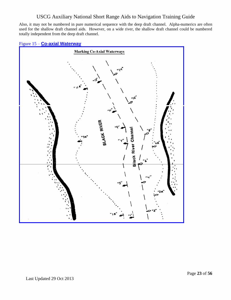
Marking of Co-axial Waterways
Occasionally, it is necessary, in a wider waterway, to mark a deep draft channel along with wider boundaries for a
shallow draft channel. In this situation, the aids in the deep draft channel are named and numbered first. The name
will include a noun indicating a feature of that route (channel, traffic lane, cut, or canal). The aids that mark the
broader expanse of water are numbered next. They would not reference the noun used for the deep draft channel.
USCG Auxiliary National Short Range Aids to Navigation Training Guide
Page 23 of 56
Last Updated 29 Oct 2013
Also, it may not be numbered in pure numerical sequence with the deep draft channel. Alpha-numerics are often
used for the shallow draft channel aids. However, on a wide river, the shallow draft channel could be numbered
totally independent from the deep draft channel.
Figure 15 – Co-axial Waterway

USCG Auxiliary National Short Range Aids to Navigation Training Guide
Page 24 of 56
Last Updated 29 Oct 2013
Variations on the Conventional Direction of Buoyage
At times, strict adherence to the use of flood to determine the conventional direction of buoyage can cause
confusion and result in an inconsistent marking scheme. This situation will likely occur near islands or river
mouths. In the figure below, an apparent confusing situation exists between points “B” and “C”. This was
eliminated by deviating from the rules and changing the direction of buoyage to go from point “B” to point “C.
Figure 16 – Variations on the direction of Conventional Buoyage

USCG Auxiliary National Short Range Aids to Navigation Training Guide
Page 25 of 56
Last Updated 29 Oct 2013
The Uniform State Waterway Marking System (USWMS)
Inland Waters Obstruction Mark. On
inland waters designated by the Commandant as
State waters in accordance with 33 CFR 66.05-5
(33 CFR 66.05-100 provides the specific listing
by State) and non-navigable internal waters of a
State which have no defined head of navigation, a
buoy showing alternate vertical black and white
stripes may be used to indicate to a vessel operator
that an obstruction to navigation extends from the
nearest shore to the buoy. The black and white
buoy's meaning is do not pass between the buoy
and the shore. The number of white and black
stripes is discretionary, provided that the white
stripes are twice the width of the black stripes.
Reference the National Navigation Systems
Division Web Site for links to these CFRs.
Figure 18 –
Inland (State) Waters
Obstruction Mark May show a white reflector or a quick
flashing white light.
Cardinal Marks These marks indicate, in the cardinal points of the compass, the direction of good water from the aid. They
are not used in the U.S. Marking System but may be encountered in state waters, per the Uniform State
Waterway Marking System.
Figure 18 - Cardinal System Marks - May show a white reflector or a white light.
Red striped white buoy
Black topped white buoy
Red topped white buoy
Do not pass between buoy and
nearest shore. Think that the black top represents a northeast storm. Pass to north or east of this buoy
Think that the red top represents heat and the hottest area is in the southwest. Pass to south or west of this buoy
USCG Auxiliary National Short Range Aids to Navigation Training Guide
Page 26 of 56
Lanterns, Navigational
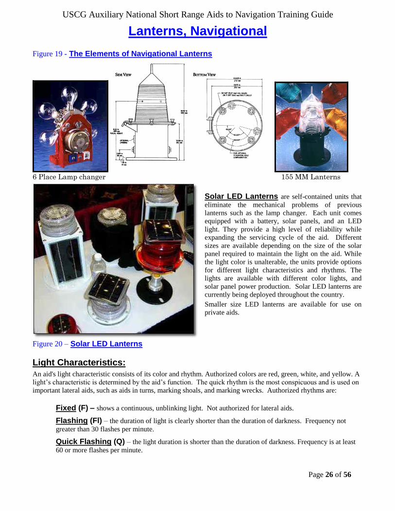
Figure 19 - The Elements of Navigational Lanterns
6 Place Lamp changer 155 MM Lanterns
Solar LED Lanterns are self-contained units that
eliminate the mechanical problems of previous
lanterns such as the lamp changer. Each unit comes
equipped with a battery, solar panels, and an LED
light. They provide a high level of reliability while
expanding the servicing cycle of the aid. Different
sizes are available depending on the size of the solar
panel required to maintain the light on the aid. While
the light color is unalterable, the units provide options
for different light characteristics and rhythms. The
lights are available with different color lights, and
solar panel power production. Solar LED lanterns are
currently being deployed throughout the country.
Smaller size LED lanterns are available for use on
private aids.
Figure 20 – Solar LED Lanterns
Light Characteristics:
An aid's light characteristic consists of its color and rhythm. Authorized colors are red, green, white, and yellow. A
light’s characteristic is determined by the aid’s function. The quick rhythm is the most conspicuous and is used on
important lateral aids, such as aids in turns, marking shoals, and marking wrecks. Authorized rhythms are:
Fixed (F) – shows a continuous, unblinking light. Not authorized for lateral aids.
Flashing (Fl) – the duration of light is clearly shorter than the duration of darkness. Frequency not
greater than 30 flashes per minute.
Quick Flashing (Q) – the light duration is shorter than the duration of darkness. Frequency is at least
60 or more flashes per minute.

USCG Auxiliary National Short Range Aids to Navigation Training Guide
Page 27 of 56
Very Quick Flashing (VQ) – the light duration is shorter than the duration of darkness. Frequency is
at least 100 flashes per minute.
Interrupted Quick Flashing (IQ) – is similar to quick flashing but has a brief, extended darkness
period.
Group Flashing (Gp Fl (x)) - Displays groups of two or more flashes. A repeating group of three
flashes would appear as Gp Fl (3). The darkness between the groups is clearly longer than the darkness
between flashes.
Composite Group Flashing (Gp Fl (x+x)) – Combination of two patterns in one period, i.e. 2
flashes followed by three flashes would appear as Gp Fl (2 + 3). The darkness in between the groups is
clearly longer than the darkness between flashes.
Long Flashing (LFL) – One long flash in a lighted period of at least 2 seconds.
Slow Flashing – less than 30 flashes per minute. The adjective ‘slow” is usually omitted.
Isophase (Iso) – Light has equal duration between light and darkness. Period consists of both light and
dark intervals. Also called Equal Interval (E Int).
Occulting (Occ) – is the opposite of flashing – the light is on more than it is off.
Alternating (AL) – an alternating light changes color. It is used as a special purpose light for situations
requiring significant caution.
Morse (Mo) – groups flashes (long and short) to form Morse code characters. Example: Morse code “A”
shows one short flash followed by one prolonged flash then a period of darkness.
Discrepancies on Lights:
The light signal is showing improper characteristics or rhythm. Must be observed during periods
of darkness.
The light signal is obscured. Explain the circumstances in the comment section on your report.
The light signal is extinguished. Must be observed during periods of darkness.
The lantern is damaged. This is always a good photo opportunity.
The light is burning dim or showing reduced intensity. Verify by close examination that the
"burning dim" or "reduced intensity" condition is not being caused by smoke, by some other atmospheric
conditions, or by the viewing angle.
The aid’s light is partially obscured by dayboards.
The battery box is missing or damaged. Note that many lighted aids are being equipped with Solar
LED Lanterns which do not need a battery box. The LED lights are self-contained fixtures—LED light,
battery and solar panel.
The vent valve on a lighted buoy is missing. Aids with Solar LED Light fixtures do not need vent
valves. When the aid has an old type hull, even though fitted with a LED lantern fixture, always check the
vent valve for integrity.
The vent tube(s) on a lighted buoy is broken. Aids with Solar LED Light fixtures do not need vent
tubes. When the aid has an old type hull, even though fitted with a LED lantern fixture, always check the
vent tubes for integrity.
Bird nests are obscuring the light.
The solar panel is damaged or is not oriented correctly. Usually does not apply to Solar LED
fixtures. However, do check for damage or vandalism.

USCG Auxiliary National Short Range Aids to Navigation Training Guide
Page 28 of 56
Ranges are an aligned pair of beacons placed to define a line
down the center of a navigable channel. They are usually, but need
not be, lighted. Criteria for range site selection are:
Use of existing structures such as lights, or daybeacons
whenever possible.
Shoal areas where shallow water depths will decrease
structure construction costs are utilized.
Figure 21 - RANGES
The Front Range (FR) panel or light is usually lower than the rear range (RR) panel or light. Each range provides
a mariner with a given lateral sensitivity at a given distance from the near end of the channel. Lateral sensitivity is
expressed as Cross-Track Factor and lends a more physical feel to the performance of the range.
The cross-track factor is a measure of effectiveness for finding and maintaining track on the range axis. A
cross-track factor of 25% means that a mariner may be as far as 25% of the distance from the channel
centerline to the edge of the channel before determining the vessel is off the centerline.
Distances of less than two miles are usually marked with dayboards and using standard omni-directional
lanterns for nighttime operation.
Distances of over four miles are commonly marked with daytime lights provided there is an operational
requirement to mark the entire channel.
Distances between 2 and 4 miles are marked as operationally required or as economical as possible.
Discrepancies on Ranges:
Range is not marking the center of the navigable channel. See the NS Nautical Chart Update
Training Guide, page 37, for instructions for the proper reporting of this discrepancy to the Coast Guard
and NOAA.
Range Panels have faded. Since fading is such a subjective opinion, use the criterion, “Can the range
panel colors be interpreted as the wrong color, such as, red for orange or yellow, green for yellow, etc.
Then, report the panel as faded. Photos are good backup evidence for this type of discrepancy.
Range panels are missing. Note that many ranges that are lighted 24/7 may not have range panels.
Recent efficiency improvements in optics combined with solar power have allowed the Coast Guard to
expand the use of daytime lighted ranges even when commercial power is not available.
Range panels are obstructed by brush or new construction. Good photo opportunity.
Range supporting structure is deteriorated, rotting, or eroding. Good photo opportunity.
Range lights are extinguished.

USCG Auxiliary National Short Range Aids to Navigation Training Guide
Page 29 of 56
Extra Pre-underway electronic equipment accuracy checks are necessary before each Navigation
Systems (NS) Patrol Navigation Systems activity and patrols require a very precise use of navigational equipment. Unfortunately, you
may find that some of the equipment found on an OPFAC does not meet the accuracy and quality standards
needed for taking on-scene fixes and depths for the Navigation Systems ATON program. Do not embarrass
yourself by submitting low quality data or by not being able to make proper measurements due to equipment
breakdowns or failure. Always be prepared. The two major problematic items are GPS sets and echo sounders.
A handheld GPS that is equipped with WAAS is a great adjunct to a navigation kit. Verify that the GPS is
operating accurately during the pre-underway check by verifying its readouts against the OPFAC’s GPS or
against a known charted position. Always indicate how your GPS was calibrated on your pre-underway checklist.
Mount the handheld GPS to a large clipboard to keep it available throughout the patrol. Purchase a power cord
for your handheld GPS that can plug into the OPFAC’s 12 volt receptacle to save your GPS batteries. Keep the
power cord in your personal Navigation Kit along with spare batteries.
As part of the OPFAC’s pre-underway check, verify that the vessel’s GPS is set up correctly. “Figure 22 –
Pre-Underway Check List for Navigation Systems Patrols” on page 30 lists special items that are
tailored for the NS volunteer. Here are a few key items that can have a serious effect on the accuracy of your
reports.
Horizontal Datum – (Position) Does it match the chart that you are using? If not, correct the horizontal
datum in the GPS set to match the nautical chart. New GPS sets usually come preset to WGS84 and most
NOAA charts have WGS84 datum references. Most USACE charts will have NAD83 datum references.
Note: Either NAD83 or WGS84 will suffice, just denote which on your report. Note that you should only
use charts with NAD83 or WGS84 for checking or verifying aids to navigation.
Vertical Datum – (Depth) Does the unit of measure on the echo sounder match the depth showing in the
General Information Block on the chart that you will be using? When they do not match, correct the depth
unit of measure on your echo sounder before you get underway.
Nautical miles vs. statute miles – (Length) New GPS sets usually come set to statute miles. Ensure
that the GPS set you use is reading out in nautical miles.
GPS headings and bearings – (Direction) Check whether the read out on the GPS set and the
compass match--True or Magnetic. Be sure that you understand how your electronic equipment is reading
before you use it.
Check that the compass is operating correctly – Validate that the OPFAC’s compass is
operating accurately. If your boat is moored to a finger float, check the reading that should be constant.
Otherwise, use a known range. Electronic compasses are equipped with deviation error compensation
features and procedures for correcting for variation error.
Have you entered your patrol’s planned route into the GPS? Have you pre-calibrated the echo sounder? This can be accomplished with a leadline or a
sounding pole. Although the results can be degraded by a muddy or silty bottom.
Is the OPFAC’s nautical chart current and updated to the latest LNM? To be safe, carry
the latest nautical charts in your navigation kit.

USCG Auxiliary National Short Range Aids to Navigation Training Guide
Page 30 of 56
Figure 22 - Pre-Underway Checklist for Navigation Systems Patrols
Boat Name
Length
OPFAC Number
State Reg. Number
Item Process Status Item Process Status
Engine Fuel - Indicate amt of fuel in tank. Boat Gear
Are there sufficient Anchors (2 required)?
Oil - Checked reservoir What is length of the Anchor Rode? ft
Is there spare oil on board? Are the heaving lines available on deck?
Is the Tool kit readably available? Are there mooring lines?
Is the Backfire Flame arrestor mounted? Are there sufficient Fenders?
Belts – good condition? – spare belt? Is there a Horn? Does it function?
Batteries – charged and covered.? Is there a Bell?
Fuel shut offs – where located? Is a Boot Hook available on deck?
Transmission fluid – checked? Radio is operating? Working channel: Alternative channel:
Engine Coolant – checked? CH
Fire Extinguisher System operational? CH
Pollution Placard mounted? Are the mooring cleats backed?
Ventilation? Bilge Blower – checked?
Are the towing cleats backed?
Is there an alternative means of bailing?
Bilge pumps – Fore and Aft? Is a MSD installed?
Nav Gear GPS Enter name and
model number.
Echo
Sounder Enter name and
model number.
Are the NOAA or USACE Charts of AOR on board?
Is there a Swim Platform or
Is there a Boarding Ladder?
Is the Navigation Kit on board?
Are the Binoculars on board? Is there a spotlight on board?
Was the compass pre-calibrated?
Read out is (True or Magnetic)?
Is a Deviation Table available?
Are there flash lights on board?
Is there a Capacity Plate?
Is there a Certificate of compliance?
Is a RPM Table available on board? Is there a galley trash disposal card?
Is there a Timepiece on board? Knife (min. 3” inches)
How was Echo Sounder pre-calibrated?
Correction for transducer location:
Are navigation lights operating properly?
Is the anchor light operating properly?
Are there spare bulbs on board?
Does the Vert. UOM match the chart?
Is the Light List on board?
Is the Coast Pilot on board? Electrical System condition? Are there spare fuses on board.?
Is the Tide Tables on board?
Is the Nav Rules on board? Is the National Ensign installed?
Forms, pencils, and paper on board? Are there Fire extinguishers plus 2?
GPS How was the GPS calibrated? Is there a First Aid Kit on board?
Is the Hor. Datum the same as chart? Are Blankets (2) available?
Does GPS Distance = Nautical Miles? Are PFDs (wearable) plus 2 available?
Heading (True or Magnetic)? Are PFDs (throwable) available on deck?
Vertical UOM (Feet, Fathoms)? Are VDS available on board?
SAR Is there a Portable Pump on board? Is Auxiliary Ensign on board?
Is Towing Harness on board? SAR Are SAR Accident Reports on board?
Is Towing Line faked out on deck? Are Patrol Orders on board?
Are Bridles available on deck? 7030 - Activity Report Mission on board?
Are Spring Lines available on deck? Are extra Fenders available on deck?
Are Sign Boards installed? Are Wire Cutters available on deck?
Is Kicker/Skiff Hook available on deck? Is SAR Plotting Guide on board?
Make copies of the checklist and keep them available in your navigation kit. Fill out this checklist before
every Navigation Systems patrol. You will need data from this checklist when preparing a discrepancy or
verification report.
USCG Auxiliary National Short Range Aids to Navigation Training Guide
Page 31 of 56
Guidelines for Checking an Aid to Navigation It is always a good practice to advise the local Coast Guard unit or entity in charge of the Aids to Navigation in
your area when you will be conducting a Navigation Systems patrol. Follow your District policy for making this
contact. There may be some specific items that need to be checked. Here are a series of suggestions for the proper
checking of a Federal Aid. Do not report a Federal Aid that is observed as “watching properly” unless expressly
asked to do so by the Coast Guard.
CAUTION - Auxiliarists are advised to always stay in the navigable channel while taking fixes and
depths alongside an aid to navigation, and to exercise extra caution when approaching fixed aids, being alert for riprap or other protection materials often located at the base of these aids.
1. Confirm the following conditions about each Aid that you check. Report any
inconsistency to the Coast Guard as an ATON discrepancy.
a. Check your on-scene observation of the aid against the aid’s characteristics in the Light
List. From the aid’s name in the Light List, you should be able to discern the aid type, the aid color,
the aid’s number or letters, the latitude and longitude, deployment schedule, whether it is a Federal or
Private aid, electronic equipment, sounding devices, fog signals, signal characteristics, light, light color,
light characteristics, RACON, light height, etc
b. Compare your on-scene observation of the aid against the charted symbols and chart
abbreviations on the NOAA or USACE chart. Verify that the charted symbol color and the light
characteristic abbreviations are correct. Confirm that the charted symbols and abbreviations match
those listed for the aid in the Light List. Report any erroneous charted abbreviations, symbol, and color
discrepancies to NOAA as chart updating corrections. Use Chart No. 1 as a reference guide.
c. For all lateral aids, verify that your observation of the aid’s characteristics—shape,
color, light, and numbering or lettering—comply with the IALA Aid to Navigation
System standards for the region you are operating in.
2. Check the location (LAT/LONG Fix) of the aid. See the Guideline for taking and reporting a fix
(Location) to the Coast Guard on page 34 of this guide.
Terminology update – The Coast Guard “positions” aids, the Auxiliary “locates” aids using
GPS fixes. There are major technological differences between these two procedures, and it is important
that we do not confuse anyone in the Coast Guard as to the technological capabilities of the Auxiliary.
Auxiliary Restriction - All floating aids are connected to the seabed with a harness and an anchor.
The Auxiliary is never allowed to pull an aid to short stay in order to determine its exact position, so an
aid may be observed anywhere within it watch circle. Since the aid’s harness length is unknown, the
aid’s watch circle can only be estimated. The location of the aid within the watch circle is affected by
the direction and force of the wind and the set of the current. The NS Horizontal and Vertical Error
Calculator available on the Navigation Systems Division Web Site provides a means to calculate the
distance an aid may be off station and also can calculate an estimated watch circle radius for the aid.
Therefore, the only valid judgment that an Auxiliarist can make is a comparison between the aid’s
assigned position and the fix taken by the member alongside the aid. Auxiliarists must realize that a
change of tide or a shift in the wind can change the location of the aid while the assigned position of the
aid, as identified by its anchor position, remains the same. Caution: Don’t assume that the aid’s
assigned position is always correct, especially for Private Aids.
While underway, keep aware whether the GPS is reading in 3D mode. Be prepared to record the EPE or
HDOP, and the date and time for every LAT/LONG fix that you take. Always think quality!
Caveat on reporting Federal Aids as “off station” – Whenever a Federal Aid is reported to

USCG Auxiliary National Short Range Aids to Navigation Training Guide
Page 32 of 56
be off station, the Coast Guard unit or ANT may have to dispatch a unit to verify the aid’s position and,
if necessary, reset it. Be sure of your estimates and calculations before you submit an off-station report.
Include the calculation details (as described in the guidelines below) with your report so that the Coast
Guard unit or entity can make a proper assessment of your report. Also indicate the type of GPS used to
determine the fix, the name and model number of the GPS, and the method used to prove the accuracy
of your GPS set at the time that the fix was taken, either the EPE or HDOP. Your accuracy and
professionalism will increase your credibility in the eyes of the Coast Guard.
Never report minor location (Lat/Long) errors. When an aid is found to be a considerable
distance off station, always check the Local Notice to Mariners or the on-line NOAA charts for any
recent changes to the aids assigned position before making a formal report. Most aids now show an
“assigned position” (LAT/LONG) in the Light List. Extract the LAT/LONG for the aid from a nautical
chart and compare it to the observed location. The reverse is also true. Use the NS Vertical and
Horizontal Error Calculator available on the Navigation Systems Division Web Site to calculate an
estimated distance that the aid is off station.
When you discover an obvious problem, it is a prudent practice to communicate directly with the Coast
Guard unit or entity to discuss the problem per your District policy. If agreement that a problem exists
is concluded, follow up the conversation with the formal discrepancy report. Hard-copy follow up
reports may not be required in some districts or with some ANTs.
3. Take the depth alongside the aid while in the navigation channel. Follow the guidelines
for taking and reporting a depth, as explained on page 35 of this training guide.
4. Scan the Aid for discrepancies. Reference the Aid Discrepancy section below for the reportable
details.
5. Double check your recorded observations for completeness and accuracy before you leave the scene. It is best to prepare your discrepancy report while still on-scene at the aid. This
practice helps avoid missing required data and saves time by not having to return to the scene in order to
collect the missing data.
USCG Auxiliary National Short Range Aids to Navigation Training Guide
Page 33 of 56
Guidelines for taking and reporting a Fix to a Federal Agency
Fixes taken for floating and fixed lateral aids need to be highly accurate. These guidelines support this
objective.
1. Perform a pre-underway check of the GPS on the OPFAC:
Verify that the DGPS or WAAS feature is activated in the GPS set.
Confirm that the horizontal datum, that is set up in the GPS set, matches the horizontal datum
printed on the NOAA chart that you plan to use during the patrol. Your NOAA chart must have a
WGS84 or NAD83 horizontal datum to be useful for Navigation Systems Program activity.
Check that the distance unit of measurement on the GPS is set to Nautical Miles for coastal
waters, or Statute Miles for the Western Rivers system.
Be sure that the unit of measure for bearing or a heading in the GPS set matches the unit of
measure read out capability of the compass that you plan to use. If using a magnetic compass, you
may need a copy of the vessel’s Deviation Table to convert bearings to true on your reports.
Set the Latitude / Longitude in the GPS to degrees, minutes, seconds and decimals. This is the
standard LAT/LONG expression in the Coast Guard. It reflects the LAT/LONG used in the Light
List.
2. Explain how the fix alongside the aid was determined and calculated.
A GPS set using WAAS, or a DGPS set are the recommended tools for taking a fix. Handheld
GPS sets with WAAS can produce LAT/LONG (Fixes) within 8 to 12 feet of the actual position of
the aid on the earth’s surface. That is inside the head of a pinhole on a chart.
Horizontal sextant angles or bearings using a hand-held compass are not considered sufficiently
accurate for use in the Navigation System’s program for taking a fix.
3. Take the Fix when close aboard lateral aids while remaining in the navigable channel.
Fixes should be taken after the vessel stops alongside the aid. Recording fixes while a vessel is in
motion can cause erroneous fixes, producing inaccurate reports.
Fixes taken for floating aids should be taken upstream and upwind of the aid in order to minimize
the effect the aid’s watch circle. The deeper the water, the greater the potential for a larger watch
circle especially at lower tide levels. Since Auxiliarists are never allowed to pull an aid’s harness
up to short stay, this practice minimizes the fix error. Note that the position of an aid is actually the location of the aid’s anchor in the seabed. The floating aid moves around on
its harness over this anchor when affected by tidal current and wind. This movement is called its
watch circle.
It is recommended that you plot each fix on a chart as a further sanity check. It may generate a
chart update report due to a charted error.
4. Record supporting quality control data for each fix that is taken.
This practice significantly improves the quality level of your report.
Include an “Accuracy Statement” on each report.
Always show the EPE—Estimated Position Error or HDOP—Horizontal Dilution of Position for
every fix taken.
Include the date and time when each fix is taken.
Also, indicate whether the GPS is operating in 3D or 3D Differential for each fix taken.
Reference the make and model of the GPS equipment that you used to determine the fix.

USCG Auxiliary National Short Range Aids to Navigation Training Guide
Page 34 of 56
Guidelines for taking and reporting a Depth reading Random reporting of depth readings from echo sounders produces incomplete data. Besides the need to control the
quality of the instrument, from a practical use, depths must relate to charted depths or depths recorded in the CG
Form 2554 or the PATON Information Document (PID). Otherwise, depths reported in areas affected by the tide
are no better than random numbers. This difference becomes more significant in areas within the higher latitudes
where tidal ranges vary 10 to 12 feet or more. Record your on-scene observations and equipment checks.
1. During the pre-underway check of the OPFACs echo sounder.
a. Check that the vertical datum shown in the “General Information Block” on a NOAA chart reflects
the depth UOM (unit of measure) that is set up on your echo sounder—feet, meters or fathoms.
b. When your echo sounder is integrated to your GPS set, verify that the depth unit of measure on the
NOAA chart, on the echo sounder, and on the GPS matches.
c. Use a leadline, a sounding pole or a hand-held depth sounder to determine the water depth.
d. Calculate the distance from the waterline to the position of the transducer on the vessel so you can
correct depth readings. (Depth reading minus the echo sounder reading.) Note: This distance is
best determined during a haulout with a tape measure and two people – one holding the tape
outboard at the gunwale and the other doing a level sighting to observe the tape’s measurement.
e. Check that the echo sounder is reading accurately. Compare the depth of water taken with a lead
line or sounding pole to the echo sounders read out plus the correction for location of the transducer
on the vessel. Or, calculate the estimated depth by comparing the echo sounder’s read out plus the
correction for the transducer on the vessel minus the height of tide. Compare the result to
previously estimated depths taken at your mooring area.
f. Carry a leadline in your navigation kit as backup so if the vessel’s depth sounder fails, you can
continue to record accurate depths during the patrol.
2. List the equipment used for taking the depth alongside the aid. List the equipment that
you use—echo sounder, lead line or sounding pole. When an echo sounder is used, also show the
manufacturer’s name and model number on your report.
3. When an echo sounder is used, list the distance from the transducer to the water line.
4. Always record and report the date and time when a depth is taken.
5. When you operate in a tidal zone area, record and report the height of tide for the time when the depth is taken. Height of tide can be read from the almanac screen on a GPS or on-
line from http://tidesonline.nos.noaa.gov. Click on NOAA Tide Predictions (for astronomically
computed), or click on CO-OPS for real tides
6. Maneuver the OPFAC so that it is upstream and upwind of a floating aid. This
technique minimizes the “Watch Circle” error and provides more exact data alongside the aid.
7. Compare the observed depth reading at datum to the charted datum. The formula for an
echo sounder is: ((Observed Depth plus Distance from transducer to the water line) minus the Height of
Tide = Estimated Depth at Datum)). The formula for a sounding pole or a lead line is: (Observed Depth
minus the Height of Tide). Large depth discrepancies can be an indication that an aid may not be on station.
In this case, you will need to take multiple readings to prove your case.
8. Include an Accuracy Statement on every report.

USCG Auxiliary National Short Range Aids to Navigation Training Guide
Page 35 of 56
Using an “ACCURACY STATEMENT”
1. A statement similar to the example provided below enhances the professionalism and credibility of your
reports. You will be recognized as a professional by the Coast Guard. It is quick and easy to prepare this
statement when you follow the example shown below.
Prepare a “copy and paste” entry on your computer similar to the following:
ACCURACY STATEMENT:
The fix was taken by a GPS 76 by Garmin with WAAS enabled that was checked
against a known location at the dock. GPS was operating in 3D Differential. EPE
was 8.5 ft.
Depth was taken with a Wide 100 by Hummingbird echo sounder that was checked
for accuracy with a lead line. Transducer correction is 0.8 ft. and a 7.5 ft. HOT-
(Height of Tide) at Substation NEPONSET RIVER on BOSTON.
The fields highlighted in blue have to be set only once or whenever you use a different OPFAC on a
patrol.
Only the fields highlighted in yellow need to be changed for each verification.
Update your Accuracy Statement, copy it from your computer and paste it in your report.
Paste your Accuracy Statement after any special comments in your report.
2. Space for much of this information is provided for on the ANSC/NS-7054 Aids to Navigation Report form.
If you do not follow these guidelines, you are not doing a complete
and accurate job of checking an Aid to Navigation.
Suggested boat crew assignments for a Navigation Systems Patrol A Navigation Systems Patrol provides a good opportunity to delegate various aid checking assignments among
your boat crew and to expose the crew to different navigational experiences. Make your patrol a team effort. You
will be able to teach members new navigation techniques keep your crew members involved with the patrol, cause
time to pass quickly, and have a lot more fun while underway.
Data Recorder – writes down the data as it is called out by other crewmembers and completes the draft
ANSC/NS-7054 Aid to Navigation Report or other worksheet before leaving the scene.
Document Checker – references copies of the Light List, NOAA chart and Coast Pilot to verify that the
observations of the aid match published data for the aid.
Instrument Reader(s) – Reads the echo sounder and/or the GPS when the OPFAC is close aboard the aid.
Use the GPS’ almanac screen to determine the Height of Tide and check the Substation. Compare the observed
depth at the charted datum to the charted depth for the aid. Also, provide the fix data (LAT/LONG) and the
quality readings of either an EPE or HDOP.
Navigator – Reviews the data on the nautical chart against the observations taken on-scene at the aid. Verifies
that the charted abbreviations for the aid match the data published in the Light List.
Observer – Checks whether the Federal Aid conforms to the IALA Aid to Navigation System standards. This
crewmember can also be assigned the duty to photograph the aid and advise the Data Recorder of the photo
number assigned by the camera.

USCG Auxiliary National Short Range Aids to Navigation Training Guide
Page 36 of 56
Short Range Aids to Navigation Discrepancies
A discrepancy to an aid to navigation is defined as a defect on the unit, which, therefore, is not watching properly.
Always reference the Light List and the latest LNM to check whether the discrepancy on the aid has been reported
previously. Discrepancies to Aids to Navigation are divided into many categories.
The numbers for these discrepancies correspond to the numbers on the ANSC/NS-7054 Aid to Navigation Report and/or any other worksheets used.
LOCATION DISCREPANCIES 1. The aid is off station. Be sure you are right before making this report. Daybeacons are seldom off station.
2. The buoy is adrift. In this situation, you can see the buoy. Radio or call for instructions from your OPFAC.
You may be instructed to take it under tow or tie it off to another aid. If possible, provide the Coast Guard with
the buoy’s serial numbers that are welded or stamped on the hull (as in the case of foam buoys). This data helps
identify the assigned position for the buoy.
3. The aid is missing. Enter the LAT/LONG of the buoy as a waypoint on your GPS and use the “GO TO”
command on your GPS to try to locate the aid. Be sure to stay in the navigable channel during this
procedure. 4. Aid is not marking the best water. When you feel the aid is not placed correctly, explain the reason in the
Comments.
CONDITION DISCREPANCIES 1. The buoy is sinking. Double check before reporting. Return to the scene after a lapse of time to check
whether the buoy is actually sinking, is an aid that floats low in the water, or is being subjected to very high
currents.
2. The buoy is stranded. Use extra caution when transiting in the area.
3. The buoy has capsized. This is a great photo opportunity.
4. The aid is damaged by vessel collision. This is a good photo opportunity.
5. Extensive bird fowling on aid. This is a good photo opportunity.
6. Peeling and rust is obscuring color. This is a good photo opportunity.
7. Numbers are missing on a lateral aid. This is a good photo opportunity.
8. Numbers or letters damaged on the aid. This is a good photo opportunity.
9. Retro-reflective material problem. This is a good photo opportunity.
10. Fixed aid is leaning more than 15 degrees. This is a good photo opportunity.
11. Extensive deterioration and/or rotting members on a structure. This is a good photo opportunity.
12. Light is obscured by foliage or brush.
LIGHTING DISCREPANCIES 1. Improper light characteristics on a lighted aid. Define the characteristic in the Comments.
2. Light is obscured or extinguished.
3. Light is burning dim. 4. Light is obscured by a dayboard. This is a good photo opportunity.
5. Lantern is damaged. This is a good photo opportunity.
6. Battery Pack is missing or damaged. Explain in Comments – good photo opportunity.
7. Solar Panel is damaged. This is a good photo opportunity.
8. Solar Panel is oriented incorrectly. Explain in Comments.
9. Missing or damaged vent valve. This is a good photo opportunity.
10. Lamp is the wrong color. Explain in the Comments.
11. Lantern is missing. Explain in the Comments and a good photo opportunity.

USCG Auxiliary National Short Range Aids to Navigation Training Guide
Page 37 of 56
DAYBOARD DISCREPANCIES:
1. Dayboards are missing. Explain on the Comments section. This is a good photo opportunity.
2. Dayboard(s) is damaged. Explain in the Comments section. This is a good photo opportunity.
3. Dayboards(s) is faded so color is comprised. This is a good photo opportunity.
4. Dayboard is delaminating. This is a good photo opportunity.
5. Dayboard(s) is obscured by foiliage or brush. This is a good photo opportunity.
6. Improper dayboard displayed per aid specification.
OTHER DISCREPANCIES: 1. Sound Signal Discrepancies.
2. Radio beacon is off the air.
3. DGPS Beacon is off the air.
DOCUMENTATION AND SPECIFICATION CHECKS 1. Observed aid does not match the entry for this aid in the Light List. Explain in Comments.
2. Observed aid does not match the symbols and abbreviations for this appearing on the NOAA or USACE
Chart.
3. Observed lateral aid does not comply with the IALA Aid to Navigation System for the region. Explain in
Comments.
4. Observed aid does not comply with the data shown in the Coast Pilot. Explain in Comments.
Important Points to Remember
Whenever a discrepancy on an aid to navigation is reported via radio, telephone or government mail, and
followed-up with an ANSC/NS-7054 Aid to Navigation Report, and the Broadcast Notice to Mariners
(BNM) has been broadcast by the Coast Guard or the USCG District Local Notice to Mariners (LNM) has been
published, then no further Auxiliary reporting about the Aid to Navigation is necessary.
When you discover a discrepancy on an Aid to Navigation and it is not listed in the LNM, assume you are the
first to discover it and report the discrepancy to the Coast Guard by the most expedient means available, per
your District policies.
NS Staff Officers, when forwarding (or reviewing as an email “cc”) Aids to Navigation discrepancy reports
should determine if the reports have been previously communicated directly to the Coast Guard unit or other
entity, and should ensure that they are not duplicated. Section 2 “Coast Guard Notification” should be
completed at the time and by whom the report is provided to the Coast Guard, in accordance with District
policies, to ensure an accurate report.
Every Auxiliary member should be checking every Aid to Navigation that they pass while underway, whether on a Navigation Systems or multi-mission patrol, for discrepancies and report to the Coast Guard. Keep extra copies of the ANSC/NS-7054 Aid to Navigation Report on
board your OPFAC for this purpose.
Federal Aids found watching properly while on a patrol are not reported to the Coast Guard, but credit for this
activity should NOT be reported to AUXDATA. On an ANSC-7030 Activity Report – Mission – Individual form, only report Federal Aids observed with a discrepancy – unless the verification is specifically requested by
the Coast Guard; then they should be reflected on the 7030.
The checking of any Aid to Navigation cannot be properly accomplished with a so-called drive-by cursory
look. At a minimum, in order to examine an aid properly, the time on-scene is estimated to take 5 to 8 minutes.
USCG Auxiliary National Short Range Aids to Navigation Training Guide
Page 38 of 56
Besides observing that the aid complies with IALA characteristics, a proper aid check involves determining the
aid’s assigned position against the observed LAT/LONG (Fix); measuring the depth, correcting it to vertical
datum with height of tide data and comparing it to charted depth; reviewing the Light List and checking the
abbreviations and symbols on the nautical against the observations of the aid; checking that the light is
displaying the correct characteristics and verifying the light’s color (at night); checking for lantern and solar
panel for damage; observing the condition of the aid’s paint; checking structures for rot or rust, viewing the
battery case, vent tubes and valves for damage, etc.
In effect, all the information presented in this training guide comes into play during the checking process. This
means that the number of aids to navigation that a member could check each hour is limited to about five aids
allowing for time of travel between the aids. The total will be less when a bridge is encountered and checked,
or when a chart update is discovered. This time estimate includes the time to prepare the reports.
Your reporting and observing productivity increases when the team checking approach is used and as your
boat crew is trained to make observations on an aid.
Allot the total aids checked or verified during a patrol among the crewmembers. The total aids checked must
equal the total aids reported. This practice eliminates double dipping.
Based on these new guidelines, it is obvious to everyone when a member has used the “old drive-by approach”
for this task, and reports large quantities of verifications within a short time interval. These new guidelines
ensure that the Coast Guard receives high quality P/ATON discrepancy reports and increases the overall
credibility of the Auxiliary while encouraging new members to participate in the Navigation Systems program.

USCG Auxiliary National Short Range Aids to Navigation Training Guide
Page 39 of 56
Guide for Reporting Navigation Systems Activity to AUXDATA
While reporting your observations of an ATON, PATON, or Bridge to the Coast Guard is a
top priority of the Navigation Systems’ programs, reporting your time and activity to
AUXDATA also is a priority. Recognition for your hard work and for District awards,
Navigation Systems activity and time spent supporting the Sector or CG ANT are all
derived from your AUXDATA System statistics.
Key points to remember when reporting time to AUXDATA are:
Section I Type of Resource fields on the ANSC-7030 Report (Boat or Individual) determines whether a
specific 7030 type is used to record crew underway time, or aid discrepancy or verification activity.
The boat’s 7030 Boat is used to report the crew’s underway time to AUXDATA for an authorized patrol.
(Navigation Systems discrepancy and verification fields cannot be accessed on this version of the 7030
form.)
A separate 7030 Individual is used to report the Navigation System activity (discrepancy or verification
information) to AUXDATA. The discrepancy and verification fields only appear on the 7030 form when
you select Navigation Systems Missions 30, 31 and 32 on a 7030 Individual.
Note: It is important that if both a 7030 Boat and a 7030 Individual are submitted, that their times do not
coincide. It is recommended for the AV to start their AUXDATA record of NS activity after the patrol
time.
Recording your time underway on a patrol.
The patrol’s coxswain or vessel owner reports the underway crew time when they submit their patrol mission report
via POMS (the Patrol Orders Management System) or via a 7030 Boat report sent directly to their FSO-IS. All
crew hours underway are reported to AUXDATA for a specific time period. This report includes all crew aboard
the facility, including any AVs who are not boat crew qualified.
When you plan a patrol dedicated to ATON, PATON or Bridge activity, suggest to the coxswain to request Mission
Code 03 (Navigation Systems Patrol) orders. However, Navigation Systems activity is often performed as part of
multi-mission patrols.
Recording your Navigation Systems activity.
Report Aid to Navigation or Bridge discrepancy and verification activities on a 7030 Individual, regardless of
whether the aid was observed on an ordered patrol or casually observed while on a recreational trip.
The guiding principles are:
1. Every individual Auxiliarist submits their own 7030 Individual report(s) to AUXDATA for discrepancy
and verification activities that they report to the Coast Guard. This holds true for aids observed while on
patrol as well as observed when not on patrol. For each discrepancy/verification reported to the Coast
Guard (on 7054s, etc.), corresponding Navigation Systems activity should be reported to AUXDATA.
2. Multiple Auxiliarists, working as a team, cannot take credit for the same activity – i.e., no double dipping.
The total number of PATONs verified, Bridges surveyed and P/ATON discrepancies reported to the Coast
Guard must equal the total number of PATONs verified, Bridges surveyed or P/ATON discrepancies that
are reported to AUXDATA, no matter how many AVs are involved in the observing process.

USCG Auxiliary National Short Range Aids to Navigation Training Guide
Page 40 of 56
When the Navigation Systems activity is performed as part of an authorized patrol, your underway time is reported
by the coxswain. You may show up to one hour over and beyond the patrol time (e.g., time to fill out reports) on a
7030 Individual report. Any time over one hour is reported to AUXDATA on a 7029 report using Code 99B.
If the aid activity did not occur on an authorized patrol, take full credit for all your time on your 7030 Individual
report.
Mission Codes for reporting Navigation Systems activity.
When reporting discrepancies or verifications to AUXDATA, the following mission codes are used on the 7030
Individual report. Selection of these mission codes causes the Navigation Systems activity fields to appear on the
7030 report.
Mission Code 30 – Use this mission code to record activity related to Federal Aids to Navigation (ATONs).
Only take credit for activity related to discrepancies observed on Federal Aids that are actually reported to
the Coast Guard.
Federal Aids observed as “Watching Properly” are never reported to the Coast Guard unless the Auxiliarist
is specifically requested by the Coast Guard to check these aids. Make note of this special authorization in
the comments section of your report. Therefore, there should be very limited “Watching Properly” reports
made to AUXDATA for Federal Aids.
Any Auxiliarist may report ATON discrepancies, however, only Aid Verifier (AV) qualified Auxiliarists
may perform ATON verifications.
Mission Code 31 – Use this mission code to record activity reported to the Coast Guard related to Private Aids
to Navigation (PATONs).
Any Auxiliarist may report PATON discrepancies, however, only Aids Verifier (AV) qualified Auxiliarists
may perform PATON verifications.
AV qualified Auxiliarists may report both “Aids Watching Properly” and “Aid Discrepancies” when
performing annual PATON verifications.
Mission Code 32 – Use this mission code to record activity reported to the Coast Guard about Bridges.
Submitting one report without the other(s) takes care of only a portion of the reporting job and leaves other
important aspects of the NS job undone. All Auxiliary Navigation Systems hourly statistics in support of the Coast
Guard are retrieved from AUXDATA. In order to provide evidence of the support hours that the Auxiliary
provides to the Coast Guard, reporting NS time to AUXDATA is extremely important. Hours reported while
underway on an authorized patrol are credited toward annual underway hour requirements for the Boat Crew
program. But, only NS Mission activity is used to calculate the statistics for Auxiliary support of the Coast Guard’s
Navigation Systems program, and any annual District NS awards, not hours.
USCG Auxiliary National Short Range Aids to Navigation Training Guide
Page 41 of 56
Private Aids to Navigation
Introduction One of the primary responsibilities of the Auxiliary Private Aids to Navigation Program is the reporting of
discrepancies observed on Private Aids to Navigation (PATONs). The Auxiliary works with the U.S. Coast Guard
to accomplish this important mission in a partnership that is focused on assisting the Coast Guard in backwater and
remote areas where the most of the private aids are normally deployed.
This National Short Range Aid to Navigation Training Guide explains the Federal Regulations for private aids and
for reporting observations of any discrepancies to the Coast Guard.
Verification vs. Checking an Aid
Checking is the process of observing an aid to navigation for potential discrepancies. Every Auxiliarist, while
underway on an OPFAC, is encouraged to observe every aid to navigation (both Federal and Private) that they pass
and report only observed discrepancies to the Coast Guard.
Verification of a private aid is reserved for certified and currently qualified Aid Verifiers (AV) who perform
verifications at the request of the Coast Guard. A private aid verification report is always submitted to the Coast
Guard, even when the aid is found “watching properly.”
33 CFR, PART 66--PRIVATE AIDS TO NAVIGATION
This is great background material to help you understand the rules and regulations associated with the Private Aid
to Navigation program. Read it carefully.
66.01-1 Basic Provisions. Unless otherwise noted, no person, public body or
instrumentality not under the control of the
Commandant, exclusive of the Armed Forces, shall
establish and maintain, discontinue, change or
transfer ownership of any aid to maritime navigation,
without first obtaining permission to do so from the
Commandant of the Coast Guard.
For purposes of clarification, the term “private aids to
navigation” includes all marine aids to navigation
operated in the navigable waters of the United States
other than those operated by the Federal Government
or those operated in State waters as private aids to
navigation.
Coast Guard authorization of a private aid to
navigation does not authorize any invasion of private
rights, nor grant exclusive privileges, nor does it
obviate the necessity of complying with any other
Federal, State or local laws or regulations.
With the exception of radar beacons (RACONS) and
shore based radar stations, operation of electronic
aids of navigation as private aids will not be
authorized.
66.01-3 Delegation of authority to District Commanders. The Commandant of the Coast Guard delegates to the
District Commanders within the confines of their
respective districts the authority to grant permission
to establish and maintain, discontinue, change or
transfer ownership of private aids to maritime
navigation and to administer the requirements of this
program.
The decisions of the District Commander may be
appealed within 30 days from the date of the
decision. The decision of the Commandant in any
case is final.
66.01-5 Application Procedure. Application to establish and maintain, discontinue,
change or transfer ownership to a private aid to
navigation shall be made to the Commander of the
Coast Guard District in which the private aid is or
will be located. Application form (CG-2554) will be
provided upon request. The applicant shall complete
USCG Auxiliary National Short Range Aids to Navigation Training Guide
Page 42 of 56
all parts of the form applicable to the aid to
navigation concerned, and shall forward the
application in triplicate to the District Commander.
The following information is required:
(a) The proposed position of the aid to navigation
by two or more horizontal angle, or bearings
and distance from charted landmarks. A section
of chart or sketch showing the proposed
location of the aid to navigation shall be
included.
(b) The name and address of the person at whose
expense the aid will be maintained.
(c) The name and address of the person who will
maintain the aid to navigation.
(d) The time and dates which it is proposed to
operate the aid.
(e) The necessity for the aid.
(f) For lights: The color, characteristic, height
above water, and description of illuminating
apparatus.
(g) For fog signals: Type (whistle, horn, bell, etc.)
and characteristic.
(h) For buoys or daybeacons: Shape, color, number,
or letter, depth of water in which located or, if a
fixed aid, height above water.
(i) For RACONS: Manufacturer and model
number of RACON, height above water of
desired installation, and requested coding
characteristic. Equipment must have FCC
authorization.
66.01-10 Characteristics. The light characteristics of a private aid to navigation
shall conform to the United States Aid to Navigation
System, except that only tungsten-incandescent light
shall be approved for electric lights.
66.01-15 Action by the Coast Guard. The District Commander receiving the PATON
application shall review it for completeness and will
assign the aid one of the following classifications:
Class 1 – Aid to navigation on marine structures or
other works which the owner(s) are legally obligated
to establish, maintain and operate by the Coast
Guard.
Class II – Aids to navigation, exclusive of Class I,
located in waters used by general navigation.
Class III – Aids to Navigation exclusive of Class I,
located in waters not ordinarily used by general
navigation.
Upon approval by the District Commander, a signed
copy of the application will be returned to the
applicant. Approval for the operation of radar
beacons (RACONS) will be affective for an initial
two year period, then subject to annual review
without submission required of the owner,
66.01-20 Inspection . All classes of private aids to navigation shall be
maintained in proper operating condition. They are
subject to inspection by the Coast Guard at any time
and without prior notice.
66.01-25 Discontinuance and removal. No person, public body or instrumentality shall
change, move or discontinue any authorized private
aid to navigation required by statute or regulation
without first obtaining permission to do so from the
District Commander.
Any authorized private aid to navigation not required
by statute or regulation (Classes II and III) may be
discontinued and removed by the owner after 30
days' notice to the District Commander to whom the
original request for authorization for establishment of
the aid was submitted.
Private aids to navigation which have been
authorized by the District Commander shall be
discontinued and removed without expense to the
United States by the person, public body or
instrumentality establishing or maintaining such aids
when so directed by the District Commander.
66.01-30 Corps of Engineers approval required for fixed aids. Before any private aid to navigation consisting of a
fixed structure is placed in the navigable waters of
the United States, authorization to erect such
structure shall first be obtained from the
District Engineer, U.S. Army Corps of Engineers in
whose district the aid will be located.
The application to establish any private aid to
navigation consisting of a fixed structure shall show
evidence that the required permit has been issued by
the Corps of Engineers.
66.01-40 Exemptions. Nothing in the preceding sections shall be construed
to interfere with, or nullify the requirements of
existing laws and regulations pertaining to the
marking of structures, vessels and other obstructions

USCG Auxiliary National Short Range Aids to Navigation Training Guide
Page 43 of 56
sunken in waters subject to the jurisdiction of the
United States, the marking of artificial islands and
structures which are erected on or over the seabed
and subsoil of the Outer Continental Shelf, or the
lighting of bridges over navigable waters of the
United States.
66.01-45 Penalties for establishment without a CG Permit. Any person, public body or instrumentality,
excluding the armed forces, who shall establish, erect
or maintain any aid to maritime navigation without
first obtaining authority to do so from the Coast
Guard, or who shall violate the regulations relative
thereto issued in this part, is subject to the provisions
of 14 U.S.C. 83.
66.01-50 Protection afforded to owners of private aids to navigation. Private aids to navigation lawfully maintained under
these regulations are entitled to the same protection
against interference or obstruction as is afforded by
law to Coast Guard aids to navigation. If interference
or obstruction occurs, a prompt report containing all
the evidence available should be made to the
Commander of the Coast Guard District in which the
aids are located.
66.01-55 Transfer of ownership. When any private aid to navigation authorized by the
District Commander, or the essential real estate or
facility with which the aid is associated, is sold or
transferred, both parties to the transaction shall
submit application to the Commander of the Coast
Guard District in which the aid is located requesting
authority to transfer responsibility for maintenance of
the aid.
The party relinquishing responsibility for
maintenance of the private aid to navigation shall
indicate on the application form (CG-2554) both the
discontinuance and the change of ownership of the
aid sold or transferred.
The party accepting responsibility for maintenance of
the private aid to navigation shall indicate on the
application form (CG-2554) both the establishment
and the change of ownership of the aid sold or
transferred.
In the event the new owner of the essential real estate
or facility with which the aid is associated refuses to
accept responsibility for maintenance of the aid, the
former owner shall be required to remove the aid
without expense to the United States. This
requirement shall not apply in the case of any
authorized private aid to navigation required by
statute or regulation (Class I) which shall be
maintained by the new owner until the conditions
which made the aid necessary have been eliminated.
State Aids to Navigation 66.05-1 Purpose. The purpose of the regulations in this subpart is to
prescribe the conditions under which state
governments may regulate aids to navigation owned
by state or local governments, or private parties. Aids
to navigation must be in accordance with the United
States Aids to Navigation System.
66.05-5 Definitions. The term State waters for private aids to navigation
means those navigable waters of the United States
which the Commandant, upon request of a State
Administrator, has designated as waters within which
a State government may regulate the establishment,
operation, and maintenance of marine aids to
navigation, including regulatory markers. The
Commandant will entertain requests to make such
designations with respect to navigable waters of the
United States not marked by the Federal government.
These designations when approved will be set forth
in separate sections by States in this subpart and will
briefly describe or identify waters so designated.
The term Uniform State Waterway Marking
System (USWMS) means the system of private aids
to navigation which may be operated in State waters.
The term State Administrator means the official of
a State having power under the law of the State to
regulate, establish, operate or maintain maritime aids
to navigation on waters over which the State has
jurisdiction.
The term State aids to navigation means all private
marine aids to navigation operated in State waters for
private aids to navigation, whether owned by a State,
political subdivisions thereof or by individuals,
corporations, or organizations.
The term regulate State maritime aids to
navigation means to control the establishment,
disestablishment, operation and maintenance of State
aids to navigation.
USCG Auxiliary National Short Range Aids to Navigation Training Guide
Page 44 of 56
66.05-10 State waters for private aids to navigation; designations; revisions, and revocations. A State Administrator, who desires to regulate State
maritime aids to navigation in the navigable waters of
the United States not marked by the Federal
Government, shall request the Commandant to
designate the specific bodies of water involved as
State waters for private aids to navigation.
The request shall be forwarded to the District
Commander in whose district the bodies of water are
located. The request shall give the name and
description of the waterway; the extent of use being
made of the waterway for marine navigation, in
general terms; an appropriate chart or sketch of the
area; and a general outline of the nature and extent of
the State aids to navigation which the Administrator
plans to establish in the waterway.
The District Commander shall review the request and
consult with the State Administrator concerning the
terms of an initial agreement to be entered into under
specific provisions. When they have arrived at terms
of an agreement satisfactory to both, the District
Commander shall forward the request to the
Commandant with his recommendations and the
terms of agreement mutually settled upon. If they
cannot reach such agreement, the District
Commander shall forward the request with his
recommendations and a statement of the points
agreed upon and the points remaining at issue.
Upon receipt of the request, the Commandant will
determine whether or not approval of the request is in
the public interest and will inform the State
Administrator and the District Commander of the
Coast Guard's decision. If the request is approved, the
designation by the Commandant of the waters in
question as State waters for private aids to navigation
will be also defined and described in this subpart.
The Commandant may, upon his own initiative or
upon request, revoke or revise any designations of
State waters for private aids to navigation previously
made by him. Written notice shall be given the State
Administrator of the action contemplated by the
Commandant. The State Administrator will be
afforded a period of not less than 30 days from the
date of the notice in which to inform the
Commandant of the State's views in the matter before
final action is completed to revoke or revise such
designation.
66.05-20 Coast Guard-State agreements. The District Commander in whose District a
waterway is located may enter into agreements with
State Administrators permitting a State to regulate
aids to navigation, including regulatory markers, in
State waters for private aids to navigation, as, in the
opinion of the District Commander, the State is able
to do in a manner to improve the safety of navigation.
When a waterway is located within the area of
jurisdiction of more than one Coast Guard
District, the District Commander in whose District
the State capital is located shall execute
the agreement in behalf of the Coast Guard. All such
agreements shall reserve to the District Commander
the right to inspect the State aids to navigation
without prior notice to the State. They
shall stipulate that State aids to navigation will
conform to the Uniform State Waterway marking
System or to the U.S. Aids to Navigation System and
that the State Administrator will modify or remove
State aids to navigation without expense to the
United States when so directed by the District
Commander, subject to the right of appeal on the part
of the State Administrator to the Commandant.
A Coast Guard-State agreement shall become
effective when both parties have signed the
agreements. In lieu of the procedure prescribed
in Sec. 66.01-5, the agreement shall constitute
blanket approval by the Commandant, of the State
aids to navigation, including regulatory markers,
established or to be established in State waters for
private aids to navigation designated or to be
designated by the Commandant.
In addition to the matters set forth in the first
paragraph of this section, Coast Guard-State
agreements shall cover the following points, together
with such other matters as the parties find it desirable
to include:
(1) A description, in sufficient detail for publication
in Notices to Mariners, of all aids to navigations
under State jurisdiction in navigable waters of the
United States in existence prior to the effective date
of the agreement which have not been previously
approved under procedures of Sec. 66.01-5.
(2) Procedures for use by the State administrator to
notify the District Commander of changes made in
State aids to navigation, as required by Sec. 66.05-25.
(3) If prior to December 21, 2003, specification of the
marking system to be used, whether the U.S. Aids to
Navigation System or the Uniform State Waterway
Marking System.
USCG Auxiliary National Short Range Aids to Navigation Training Guide
Page 45 of 56
(4) Specification of standards as to minimum size and
shape of markers, the use of identifying letters, the
use of reflectors or retroreflective materials, and any
other similar standards so as to enable Coast Guard
inspectors to determine compliance with Statewide
standards.
66.05-25 Change and modification of State aids to navigation. Wherever a State Administrator shall determine the
need for change in State aids to navigation, he shall
inform the District Commander of the nature and
extent of the changes as soon as possible, preferably
not less than 30 days in advance of making the
changes.
66.05-30 Notice to Mariners. The District Commander may publish information
concerning State aids to navigation, including
regulatory markers, in the Coast Guard
Local Notices to Mariners as he deems necessary in
the interest of public safety.
Notices to Mariners which concern the establishment, disestablishment, or change of State aids to navigation, including regulatory markers, may be published whenever the aids to navigation concerned are covered by navigational charts or maps issued by the National Ocean Service or the U.S. Army Corps of Engineers. 66.05-35 Private aids to navigation other than State owned. No person, public body or other instrumentality not
under control of the Commandant or the State
Administrator, exclusive of the Armed Forces of the
United States, shall establish, erect or maintain in
State waters for private aids to navigation any aid to
navigation without first obtaining permission to do so
from the State Administrator. Discontinuance of any
State aids to navigation may be effected by order of
the State Administrator. 66.05-40 Corps of Engineers' approval. In each instance where a regulatory marker is to be
established in navigable waters of the United States
which have been designated by the Commandant as
State waters for private aids to navigation, the State
Administrator is responsible for obtaining prior
permission from the District Engineer, U.S. Army
Corps of Engineers concerned, authorizing the State
to regulate the water area involved, or a statement
that there is no objection to the proposed regulation
of the water area. A copy of the Corps of Engineers
permit or letter of authority shall be provided by the
Administrator to the District Commander upon
request.
Similarly, where an aid to navigation is to be placed
on a fixed structure or a mooring buoy is to be
established in State waters for private aids to
navigation, the State Administrator shall assure that
prior permission or a statement of no objection to the
structures or mooring buoys proposed is obtained
from the District Engineer concerned. A copy of the
permit or letter is not required by the District
Commander.
66.05-100 Designation of navigable waters as State waters for private aids to navigation. In accordance with the procedures contained in Sec.
66.05-10(d), the following navigable waters listed by
the State in which they are located, are designated as
State waters for private aids to navigation:
(a) Arizona. The portion of Lake Havasu within the
State, except that portion within Havasu Lake
National Wildlife Refuge.
(b) Louisiana. The portion of Toledo Bend Reservoir
within the State.
(c) Missouri. Teach water within the State except
the:
(1) Mississippi River; and
(2) Missouri River.
(d) Montana. The portion of Missouri River between
the U.S. Highway 287 bridge near Townsend and
Great Falls including the following impoundments:
(1) Black Eagle Dam Reservoir.
(2) Canyon Ferry Reservoir.
(3) Hauser Lake.
(4) Holter Lake.
(5) Rainbow Dam Reservoir.
(e) North Carolina. Each navigable water within the
State not marked with Coast Guard aids to navigation
on June 1, 1973.
(f) Pennsylvania. The portion of Youghiogheny River
Reservoir within the State.
(f-1) South Carolina.
(1) The portion of Lake Wylie within the
State;
(2) Lake Marion;
(3) Lake Moultrie; and (4) Lake Murray.
(g) Texas. The portion of Toledo Bend Reservoir
within the State.
(h) Virginia.

USCG Auxiliary National Short Range Aids to Navigation Training Guide
Page 46 of 56
(1) Claytor Lake, on the New River in Pulaski
County.
(2) Leesville Lake, on the Roanoke River
below Smith Mountain Dam.
(3) The portions of the following reservoirs
within
the State:
(i) Gaston.
(ii) Holston.
(iii) John H. Kerr.
(iv) Philpott.
(i) Wisconsin. Navigable waters within the State not
marked with Coast Guard aids to navigation as of
May 1, 1996.
Uniform State Waterway Marking System Sec. 66.10-1 General. Until December 31, 2003, the Uniform State
Waterway Marking System's (USWMS) aids to
navigation provisions for marking channels and
obstructions may be used in those navigable waters
of the U.S. that have been designated as state waters
for private aids to navigation and in
those internal waters that are non-navigable waters of
the U.S. All other provisions for the use of regulatory
markers and other aids to navigation shall be in
accordance with United States Aid to Navigation
System.
The USATONS may be used in all U.S. waters under
state jurisdiction, including non-navigable state
waters.
66.10-15 Aids to navigation. USWMS aids to navigation may have lateral or
cardinal meaning.
On a well defined channel including a river or other
relatively narrow natural or improved waterway, an
aid to navigation shall normally
be a solid colored buoy. A buoy which marks the left
side of the channel viewed looking upstream or
toward the head of navigation shall be colored all
black. A buoy which marks the right side of the
channel viewed looking upstream or toward the head
of a navigation shall be colored all red. On a well
defined channel, solid colored buoys shall be
established in pairs, one on each side of the navigable
channel which they mark, and opposite each other to
inform the user that the channel lies between the
buoys and that he should pass between the buoys.
On an irregularly defined channel, solid colored
buoys may be used singly in staggered fashion on
alternate sides of the channel provided they are
spaced at sufficiently close intervals to inform the
user that the channel lies between the buoys and that
he should pass between the buoys.
Where there is no well-defined channel or when a
body of water is obstructed by objects whose nature
or location is such that the obstruction can be
approached by a vessel from more than one direction,
supplemental aids to navigation having cardinal
meaning (i.e., pertaining to the cardinal points of the
compass, north, east, south, and west) may be used.
The use of an aid to navigation having cardinal
meaning is discretionary provided that the use of
such a marker is limited to wholly State owned
waters and the State waters for private aids to
navigation as defined and described in this part
Aids to navigation conforming to the cardinal system
shall consist of three distinctly colored buoys.
(1) A white buoy with a red top may be used to
indicate to a vessel operator that he must pass to the
south or west of the buoy.
(2) A white buoy with a black top may be used to
indicate to a vessel operator that he must pass to the
north or east of the buoy.
(3) In addition, a buoy showing alternate vertical
red and white stripes may be used to indicate to a
vessel operator that an obstruction to navigation
extends from the nearest shore to the buoy and that
he must not pass between the buoy and shore. The
number of white and red stripes is discretionary,
provided that the white stripes are twice the width of
the red stripes.
66.10-35 Navigation lights. A red light shall only be used on a solid colored red
buoy. A green light shall only be used on a solid
colored black or a solid colored green buoy. White
lights shall be used for all other buoys. When a light
is used on a cardinal system buoy or a vertically
striped white and red buoy, it shall always be quick
flashing.
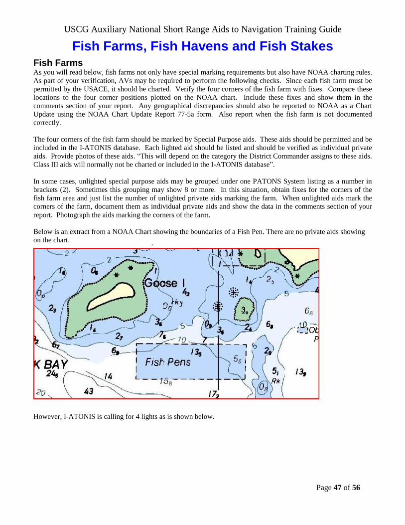
USCG Auxiliary National Short Range Aids to Navigation Training Guide
Page 47 of 56
Fish Farms, Fish Havens and Fish Stakes
Fish Farms As you will read below, fish farms not only have special marking requirements but also have NOAA charting rules.
As part of your verification, AVs may be required to perform the following checks. Since each fish farm must be
permitted by the USACE, it should be charted. Verify the four corners of the fish farm with fixes. Compare these
locations to the four corner positions plotted on the NOAA chart. Include these fixes and show them in the
comments section of your report. Any geographical discrepancies should also be reported to NOAA as a Chart
Update using the NOAA Chart Update Report 77-5a form. Also report when the fish farm is not documented
correctly.
The four corners of the fish farm should be marked by Special Purpose aids. These aids should be permitted and be
included in the I-ATONIS database. Each lighted aid should be listed and should be verified as individual private
aids. Provide photos of these aids. “This will depend on the category the District Commander assigns to these aids.
Class III aids will normally not be charted or included in the I-ATONIS database”.
In some cases, unlighted special purpose aids may be grouped under one PATONS System listing as a number in
brackets (2). Sometimes this grouping may show 8 or more. In this situation, obtain fixes for the corners of the
fish farm area and just list the number of unlighted private aids marking the farm. When unlighted aids mark the
corners of the farm, document them as individual private aids and show the data in the comments section of your
report. Photograph the aids marking the corners of the farm.
Below is an extract from a NOAA Chart showing the boundaries of a Fish Pen. There are no private aids showing
on the chart.
However, I-ATONIS is calling for 4 lights as is shown below.

USCG Auxiliary National Short Range Aids to Navigation Training Guide
Page 48 of 56
The assumption is that these lights are marking the four corners. In this case, you would verify each of these
lighted aids. If they are not marking the four corners of the fish farm, you would also document each corner and
check the fix against the charted positions.
Ideally, the four corners of the pen area should be marked. If the pen area is close by a federal channel, the outer
two aids near the channel should be lighted. If the owner chooses not to mark the four corners of the fish pen, then
they need to permit each and every marker in the area.
Note: Fish farms are not permitted to private interests. For liability reasons, they are permitted to municipalities by
the USACE-Corp of Engineers. The boundaries are established by the USACE (US Army Corps of Engineers)
who reports them to NOAA for charting purposes.
Fish Havens Report obstructions, lights, and fixes of boundary locations of the area blocked or covered by the fish haven.
The picture shows a buoy marking a boundary position for the fish haven. Many of these
buoys will be private aids. Check the Light List for the aids’ assigned positions or take the
LAT/LONG from a nautical chart. Also, submit a report to the Coast Guard. Report light
colors, characteristics, and rhythms. Fish havens are usually marked with special purpose aids
and, if lighted, yellow lights. Some may be marked by white/orange regulatory marks.
Fish havens are not “permitted” to private interests. For liability reasons, the USACE permits
them to municipalities. Usually, fish havens are designed to simulate natural reefs and wrecks
that attract fish. The reefs are constructed by intentional placement of assorted secondary-use
materials and designated fishery habitat, ranging from old trolley cars and barges to scrap
building material in areas which may be of very small extent or may stretch a considerable
distance along a depth curve; old automobile bodies are a commonly used material. The Corps
of Engineers must issue a permit, specifying the location and depth over the reef, before such a
reef may be built. However, the reef builders’ adherence to permit specifications can be
checked only with a wire drag. Fish havens are outlined and labeled on the charts and show the
minimum authorized depth when known.

USCG Auxiliary National Short Range Aids to Navigation Training Guide
Page 49 of 56
On a chart, fish havens are tinted blue if they have a minimum authorized depth of 11 fathoms (66 feet) or less or if
the minimum authorized depth is unknown and they are in depths greater than 11 fathoms but still considered a
danger to navigation.
Be cautious about passing over fish havens or anchoring in their vicinity.
Fish Stakes Report visible and submerged stakes located outside of its charted trap area.
Take fixes to define the extent of the fish stake area. Plot the area on a
nautical chart.
Indicate whether and how the area is lighted. Provide the light color and
characteristics with your report.
Also, report your observations to the Coast Guard per your District
policies.
If you suspect submerged fish stakes, survey the area at low tide from a
navigable channel or deep water area.
Operate with extreme caution near the fish stake areas
Fish Trap Areas Show the limits of the area covered by the fish trap with fixes. Plot
them on a nautical chart. Report the light colors and characteristics.
Also, report your observations to the Coast Guard. If the trap is
observable above water, submit photos to prove your report
Fish trap areas are areas established by the U.S. Army Corps of
Engineers, or State or local authority, in which traps may be built
and maintained according to established regulations. The fish stakes,
which may exist in these areas, are obstructions to navigation and
may be dangerous.
The limits of fish trap areas and a cautionary note are found on the chart.

USCG Auxiliary National Short Range Aids to Navigation Training Guide
Page 50 of 56
How to Take and Report Quality Photographs as Supporting Documentation
A picture says a thousand words, and pictures of discrepancies can be really great support
documentation for the Coast Guard of exactly what you have observed in the field. Here are some
hints on how to take good shots of Aids to Navigation and Bridges.
1. Verify the aid or survey the bridge before taking the picture. The verification and survey
process may expose specific discrepancies where close up photos will be needed.
2. Find the best angle, side and lighting. If it is not sunny, use a flash. Darkened photos are
hard to read and often do not clearly show the problem that you are trying to display.
They are not professional. Take multiple photos and view them as you take them to be
sure you have a photo that clearly shows the problem you are reporting.
3. Mark or record each photo carefully so they can be readily identified later on.
4. Use a color digital camera as much as possible. Clear black and white photos are
acceptable.
5. Include all identifying markings on the aid.
6. If needed, use a photo shop program, MS PowerPoint, or draw on the photo to highlight
hard to see details.
7. If reporting on an existing aid or bridge, include the distance and bearing from the object
to the location of your photo. If reporting on a new structure, take a fix at the photo’s
location as well
Identify your aid photos in accordance with your District’s policy. An example of one method follows:
1. Federal and Permitted Private Aids in the Light List.
a. Identify the photo with the two-digit Division number where they are located,
followed by a dash (-), followed by the LLNR for the aid, or if none, followed by the
Aid Number.
b. All Federal Aids are listed in the Light List.
c. For Example: 03-22345.01 represents LLNR 22345.01 in Division 3. You may also
add a brief description of the aid.
2. Permitted Private Aids not in the Light List:
a. Treat Private Aids that are not listed in the Light List as described in (1) above.
b. Identify the photo with the two-digit Division number where they are located,
followed by a dash (-), followed by the Aid Number.
c. For example: 02-100134556009 represents Aid Number 100134556009 in Division 2.
You may also add a brief description of the aid.
3. Non-Permitted Aids:
a. Identify the photo with the two-digit Division number where they are located,
followed by a dash (-), followed a brief description of the aid.
b. For example: 24-WestRiverFloatFreeChannelBuoy1 represents Float Free Channel
Buoy #1 in the West River in Division 24.
c. Use this same description on the photo as on the Non-Permitted PATON Report.
Submit in accordance with your District’s policy for reporting non-permitted aids. It

USCG Auxiliary National Short Range Aids to Navigation Training Guide
Page 51 of 56
is a good practice to attach a copy of the photo to your report. Digital photos can also
be pasted into the Comments section of the NS-7054.
4. Bridge Photos: E-mail photos in accordance with your District’s policy when
submitting your Bridge Survey or Discrepancy Report
BASED ON EXPERIENCE, upon receipt of good photos as evidence
of a reported discrepancy, the Coast Guard responds very quickly to
resolve the problem. This has been true of both the CG ANTs and
the Bridge Branch.
USCG Auxiliary National Short Range Aids to Navigation Training Guide
Page 52 of 56
LIST OF ACRONYMS and TERMS
AAPS - Automated Aid Positioning System –
A computer program used by the Coast Guard
to position and take fixes on aids to
navigation.
ADRIFT – Afloat and unattached in any way
to the shore or seabed.
ADSO - Assistant District Staff Officer.
AID TO NAVIGATION – any device
external to a vessel intended to assist
navigators in determining their position or
safe course, or to warn them of dangers or
obstructions to navigation
ANT – Aid to Navigation Team.
ANSC - Auxiliary National Supply Center.
Usually is a prefix to a code or number.
ASC – Auxiliary Sector Coordinator - An
Auxiliarist assigned as the Auxiliary Contact
person with a CG Sector.
ASSIGNED POSITION – the latitude and
longitude position of record for an aid to
navigation.
ATON - Aid to Navigation – reference is
directed specifically for a Federal aid to
navigation.
AUC – Auxiliary Unit Coordinator - An
Auxiliarist assigned as the Auxiliary contact
person with a CG ANT or Station.
AUXDATA – Auxiliary Data System.
AUXLO – Auxiliary Liaison Officer - An
active-duty Coast Guard person assigned as
the liaison to local Auxiliary flotillas.
AV - Aid Verifier.
BAP – Bridge Administration Program
BC-PNB - National Branch Chief,
Navigation Systems, Bridge Administration.
BC-PNC - National Branch Chief,
Navigation Systems - Cartographic.
BC-PNI - National Branch Chief, Navigation
Systems – Information Systems.
BC-PNP - National Branch Chief, Navigation
Systems - Private & Federal Aids.
BIFURCATION – The point where a channel
divides when proceeding from seaward. The
place where two tributaries meet or join to form
one waterway.
BNM – Broadcast Notice to Mariners - A radio
broadcast by the Coast Guard designed to
provide important marine information.
C&GS - Charting and Geodetic Services.
CDB – Conventional Direction of Buoyage
CFR - Code of Federal Regulations.
COMMISSION – The action of placing a
previously discontinued aid to navigation back
on station.
CU - Chart Updating Program.
DGPS - Differential Global Positioning
System.
DIRAUX - Director of Auxiliary.
DISCONTINUE – To remove from operation
(Permanently or Temporarily) a previously
authorized aid to navigation.
DISCREPANCY – Failure of an aid to
navigation to maintain its position or function
as prescribed in the Light List.
DSO- District Staff Officer.
DVC-PN - Chief, Navigation Systems
Division, Auxiliary National Staff
EPE - Estimated Position Error – GPS.
ESTABLISH – To place an aid to navigation
for the first time.
EXPOSED LOCATION – An offshore area
which is not sheltered by adjacent land and,
therefore, may be exposed to extreme weather
and sea condition.
EXTINGUISHED – A lighted aid to
navigation which fails to show a light
characteristic.
FOG DETECTOR – An electronic device
used to automatically determine conditions of
visibility which warrant the activation of a
sound signal or additional light signals.
FSO - Flotilla Staff Officer.
GPS - Global Positioning System.

USCG Auxiliary National Short Range Aids to Navigation Training Guide
Page 53 of 56
HDOP – Horizontal Dilution of Position -
GPS.
IALA - International Association of
Lighthouse Authorities.
I-ATONIS – The Coast Guard Integrated
Aids to Navigation Information System - A
national database containing every federal and
most private aids to navigation.
INOPERATIVE – Sound signal or electronic
aid to navigation that is out of service due to a
malfunction.
JUNCTION – The point where a channel
divides when proceeding seaward or the place
where a tributary departs (splits off) from a
main channel.
KNOTS (KTS) - Nautical Miles per Hour.
LAT - Latitude
LNM - Local Notice to Mariners - A written
document issued by each U.S. Coast Guard
district to disseminate important information
affecting aids to navigation, dredging, marine
construction, special marine activities, and
bridge construction on waterways within the
district.
LONG - Longitude
LOP - Line of Position.
LUMINOUS RANGE – The distance at
which a light is visible based on the visibility
of an area.
MARK – An artificial or natural object of
easily recognizable shape and color, situated
in such a position that it may be identified on
a chart. An aid to navigation.
MPH - Statute Miles per Hour.
NGAHTC – National Geospatial-
Intelligence Agency
Hydrographic/Topographic Center.
Formerly the Defence Mapping Agency.
NOAA - National Oceanic and Atmospheric
Administration
NOMINAL RANGE - The luminous range
of a light when the meteorological visibility is
10 nautical miles, and a threshold of
luminance of 0.67 sea-mile candela is used.
NON-PERMITTED – A Private Aid to
Navigation Application form (CG-2554) has not
been submitted to the District (dpw) office for
approval.
NOS – NOAA National Ocean Service.
NS – Navigation Systems - used when
referencing all of the programs in the program or
the department.
OFF STATION – A floating aid to navigation
not on its assigned position.
OINC or OIC- Officer in Charge.
OPCON – Operating Facility Number assigned
to a CG Command.
OPERATIONAL RANGE – The distance at
which a light is required to be seen to meet the
user requirements.
OPFAC – Operational Facility
OTO - Assistant Director of Auxiliary,
Operations and Training Officer.
PA – Position Approximate. Notation found
on a nautical chart when the exact position is
unknown.
PATON - Aid to Navigation – reference is
specifically directed to a Private Aid to
Navigation..
PROTECTED LOCATION – Inshore areas
that are not exposed to extremes of weather and
sea condition.
RELIGHTED – An extinguished aid to
navigation returned to its advertised light
characteristics.
REPLACED – An aid to navigation previously
off station, adrift or missing, restored by
another aid to navigation different type and/or
characteristics.
RESET – A floating aid to navigation
previously off station, adrift, or missing,
returned to its assigned position (station).
SCC – Sector Command Center
SCF – Small Craft Facility.
SEMI-EXPOSED LOCATION – Offshore or
inshore areas that may be sheltered by adjacent
land and are exposed to lesser extremes of
weather and sea conditions.
USCG Auxiliary National Short Range Aids to Navigation Training Guide
Page 54 of 56
SHORT RANGE ATON SYSTEM – An aid
to navigation system consisting devices
within visual, audio, or radar range of the
mariner.
SOUND SIGNAL – A device which
transmits sound intended to provide
information to mariners during periods of
restricted visibility and foul weather.
WAAS - Wide Area Augmentation System -
GPS.
WAMS - Waterway Analysis Management
System.
WATCHING PROPERLY – An aid to
navigation on its assigned position exhibiting the
advertised characteristics in all respects.
WATERWAY – A water area providing a
means of transportation from one place to
another, principally a water area providing a
regular route for water traffic, such as a bay,
channel, passage, river, or the regularly
traveled parts of the open sea.
WITHDRAWN – The discontinuance of a
floating aid to navigation during severe ice
conditions or for the winter season.
XPO - Executive Petty Officer.
XTE - Cross Track Error.
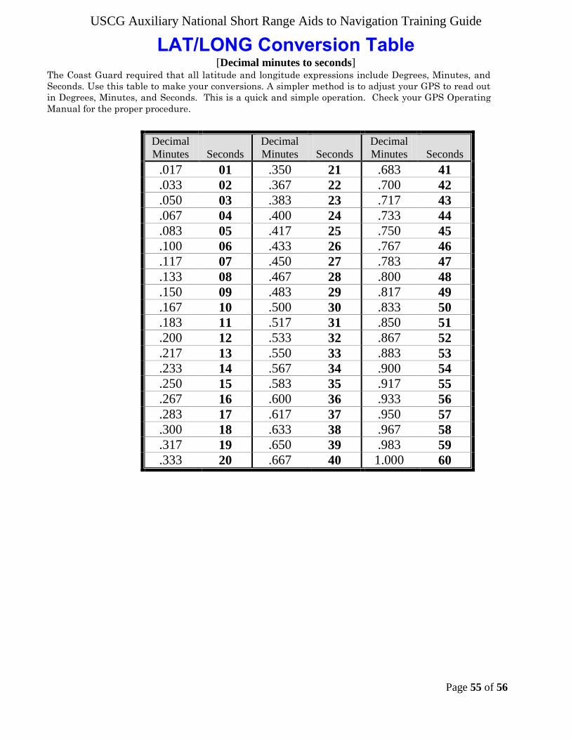
USCG Auxiliary National Short Range Aids to Navigation Training Guide
Page 55 of 56
LAT/LONG Conversion Table [Decimal minutes to seconds]
The Coast Guard required that all latitude and longitude expressions include Degrees, Minutes, and
Seconds. Use this table to make your conversions. A simpler method is to adjust your GPS to read out
in Degrees, Minutes, and Seconds. This is a quick and simple operation. Check your GPS Operating
Manual for the proper procedure.
Decimal
Minutes
Seconds
Decimal
Minutes
Seconds
Decimal
Minutes
Seconds
.017 01 .350 21 .683 41
.033 02 .367 22 .700 42
.050 03 .383 23 .717 43
.067 04 .400 24 .733 44
.083 05 .417 25 .750 45
.100 06 .433 26 .767 46
.117 07 .450 27 .783 47
.133 08 .467 28 .800 48
.150 09 .483 29 .817 49
.167 10 .500 30 .833 50
.183 11 .517 31 .850 51
.200 12 .533 32 .867 52
.217 13 .550 33 .883 53
.233 14 .567 34 .900 54
.250 15 .583 35 .917 55
.267 16 .600 36 .933 56
.283 17 .617 37 .950 57
.300 18 .633 38 .967 58
.317 19 .650 39 .983 59
.333 20 .667 40 1.000 60
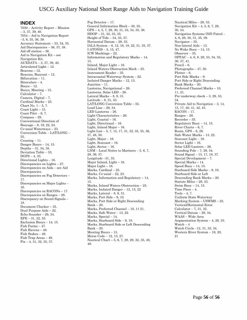
USCG Auxiliary National Short Range Aids to Navigation Training Guide
Page 56 of 56
INDEX 7030 – Activity Report – Mission
– 3, 37, 39, 40.
7054 – Aid to Navigation Report
–3, 6, 35, 36, 39.
Accuracy Statement – 33, 34, 35.
Aid Discrepancies – 36, 37, 38.
Aid off station – 36.
Aid to Navigation Kit – see
Navigation Kit.
AUXDATA – 3, 37, 39, 40.
Articulated Light – 12.
Beacons – 12.
Beacons, Buoyant – 12.
Bifurcation – 11.
Binoculars – 4.
Buoys – 12.
Buoys, Mooring – 15.
Calculator – 7.
Camera, Digital – 7.
Cardinal Marks – 25.
Chart No. 1 – 5, 7.
Coast Light – 15.
Coast Pilot – 6, 7.
Compass – 29.
Conventional Direction of
Buoyage – 8, 19, 22, 24.
Co-axial Waterways – 23.
Conversion Table – LAT/LONG –
55.
Crossing – 11.
Danger Buoys – 14, 15.
Depths – 31, 34, 35.
Deviation Table – 33.
DGPS – 4, 33.
Directional Lights – 16.
Discrepancies on Lights – 27.
Discrepancies on Aids – see Aid
Discrepancies.
Discrepancies on Fog Detectors –
17.
Discrepancies on Major Lights –
16.
Discrepancies on RACONs – 17.
Discrepancies on Ranges – 28.
Discrepancy on Sound Signals –
18.
Document Checker – 35.
Dual Purpose Aids – 22.
Echo Sounder – 29, 34.
EPE – 31, 32, 33.
Exclusion Buoys – 14, 15.
Fish Farms – 47.
Fish Havens – 48.
Fish Stakes – 49.
Fish Trap Areas – 49.
Fix – 4, 31, 32, 35, 37.
Fog Detector – 17.
General Information Block – 30, 35..
GPS – 4, 5, 7, 29, 30, 31, 33, 34, 35, 36.
HDOP – 31, 32, 33, 35.
Height of Tide – 34, 35, 37.
Horizontal Datum – 29, 33.
IALA System – 8, 12, 16, 18, 22, 31, 35, 37.
I-ATONIS – 5, 15, 47.
ICW Markings – 22.
Information and Regulatory Marks – 14,
15.
Inland, Major Light – 16.
Inland Waters Obstruction Mark – 25.
Instrument Reader – 35.
Intracoastal Waterway System – 22.
Isolated Danger Marks – 12, 13.
Junction – 11.
Lanterns, Navigational – 26.
Lanterns, Solar LED – 26.
Lateral Marks – 8, 9, 31.
Latitude – 8, 31, 33.
LAT/LONG Conversion Table – 55.
Lead Line – 29, 34.
LED Lanterns – 26.
Light Characteristics – 26.
Light, Coastal – 16.
Light, Directional – 16.
Light, Inland Major – 16.
Light List – 5, 7, 15, 17, 31, 32, 33, 35, 36,
37, 48, 50.
Light, Major – 16.
Light, Seacoast – 16.
Light, Sector – 16.
LNM – Local Notice to Mariners – 5, 6, 7,
29, 36, 37.
Longitude –31, 33.
Major Inland, Light – 16.
Major Light – 16.
Marks, Cardinal – 25.
Marks, Co-axial – 22, 23.
Marks, Information and Regulatory – 14,
15.
Marks, Inland Waters Obstruction – 25.
Marks, Isolated Danger – 12, 13, 22
Marks, Lateral – 8, 9, 31.
Marks, Port Side – 9, 10.
Marks, Port Side or Right Descending
Bank – 20.
Marks, Preferred Channel – 10, 11 21.
Marks, Safe Water – 13, 22.
Marks, Special – 14.
Marks, Starboard Side – 9, 10.
Marks, Starboard Side or Left Descending
Bank – 20.
Mooring Buoys – 15.
Morse Code – 12, 13, 27.
Nautical Chart – 5, 6, 7, 28, 29, 32, 35, 48,
49.
Nautical Miles – 29, 33.
Navigation Kit – 4, 5, 6, 7, 29,
30, 34.
Navigation Systems (NS) Patrol –
4, 6, 29, 30, 31, 35, 39.
Navigator – 35.
Non-lateral Aids – 13.
No Wake Buoy – 14, 15.
Observer – 35.
OPFAC – 4, 6, 8, 29, 33, 34, 35,
36, 37, 41.
Pencil – 6.
Photographs – 47, 50.
Plotter – 6.
Port Side Marks – 9.
Port Side or Right Descending
Bank Marks – 20.
Preferred Channel Marks – 10,
11, 21.
Pre-underway check – 3, 29, 33,
34.
Private Aid to Navigation – 3, 14,
15, 17, 40, 41, 42, 43.
RACON – 17.
Ranges – 28.
Recorder – 35.
Regulatory Buoy – 14, 15.
River Charts – 6, 7.
Route, GPS – 6, 29.
Safe Water Marks – 13, 22.
Seacoast Light – 16.
Sector Light – 16.
Solar LED Lantern – 26.
Sounding Pole – 7, 29, 34.
Sound Signal – 13, 17, 18, 37.
Special Development – 7.
Special Marks – 14.
Speed Buoy – 14, 15.
Starboard Side Marks – 9, 10.
Starboard Side or Left
Descending Bank Marks – 20.
Statute Miles – 29, 33.
Swim Buoy – 14, 15.
Time Piece – 4.
Tools – 4, 7.
Uniform State Waterway
Marking System – USWMS – 25.
Vertical/Horizontal Error
Calculator – 7, 31, 32.
Vertical Datum – 29, 34.
WAAS – Wide Area
Augmentation System – 4, 29, 33.
Watch – 4
Watch Circle –12, 31, 33, 34.
Western River System – 19, 20,
21