
UNITED KINGDOM NATIONAL REPORT - IHO
18
UNITED KINGDOM NATIONAL REPORT to the 15 TH EAST ATLANTIC HYDROGRAPHIC COMMISSION (EAtHC) MEETING LAGOS 17 - 19 OCTOBER 2018 This report supplements the UK Generic National Report, posted on the UKHO website Gov.uk/ukho EAtHC 15-04R UK National Report
Transcript of UNITED KINGDOM NATIONAL REPORT - IHO

UNITED KINGDOM NATIONAL REPORT
to the
15TH EAST ATLANTIC HYDROGRAPHIC COMMISSION
(EAtHC) MEETING
LAGOS
17 - 19 OCTOBER 2018
This report supplements the UK Generic National Report, posted on the UKHO website
Gov.uk/ukho
EAtHC 15-04R UK National Report

Page 2 of 18
Version 1.0
Page intentionally left blank

Page 3 of 18
Version 1.0
1. UK HYDROGRAPHIC OFFICE (UKHO)
UK Delivery of Hydrographic Services
1.1 The UK delivery of hydrographic services is described in the UK Generic National Report. However, it is worth highlighting the close liaison which exists between UK’s Hydrographic Office (UKHO) and UK’s maritime administration Maritime & Coastguard Agency (MCA) in providing a co-ordinated approach to hydrographic and maritime safety representation both nationally and internationally.
UKHO Governance and Targets
1.2 This is described in the UK Generic National Report to the IHO, see www.gov.uk/government/organisations/uk-hydrographic-office/about
UKHO Organisation
1.3 Details of the UKHO’s organisation are provided in the UK Generic National Report (section 1) together with general contact details. Specific contact details relevant to the EAtHC region are included at the end of this report.
Production Systems
1.4 This is described in the UK Generic National Report.
1.5 The UK is committed to bilateral arrangements, developed in co-operation with other international government hydrographic authorities, covering a range of topics, including the use of copyright data. These also promote other forms of co-operation between the participants, helping to enhance international maritime safety and protection of the environment.
2. SURVEYS
2.1 Details of the management of civil hydrographic surveys in UK Home Waters are provided in the UK Generic National Report, and on the UKHO website. UK’s National Hydrographic Committee (known as the Civil Hydrography Annual Seminar (CHAS)) meets on
Cooperation and Partnerships

Page 4 of 18
Version 1.0
an annual basis and provides the necessary breadth of interests to ensure that all surveying requirements are taken into account when prioritising the work of the Civil Hydrography Programme (CHP). CHAS was expanded in 2007 to include a much wider range of organisations, which conduct hydrographic surveys, and has been considerably successful in promoting co-operation between these organisations.
2.2 The UK government’s Commonwealth Marine Economies (CME) Programme aims to support the sustainable economic growth of Small Island Developing States (SIDS) by maximising the potential of their marine resources, helping to improve their resilience to climate change and natural disasters, protect their environment and food security, and ultimately improve the livelihood of local communities. The CME Programme is now in its third year and the UK’s former Foreign Secretary, Rt Hon. Boris Johnson, announced a further £9million funding for the next two years of the programme. The UKHO continues to take a leading role in this programme with a series of surveys, equipment procurement and capacity building planned for the next two years.
2.3 The UK Overseas Territories Seabed Mapping Programme has central government funding to assess and redress the deficit of bathymetric data and lack of sound hydrographic governance in the UK’s Overseas Territories (OTs). The programme is now in its third year and with a budget of £4.2million, will see significant surveys being undertaken in the BVIs, Anguilla, the Turks and Caicos Islands and St Helena. Further, an MSI and Hydrographic Governance workshop is being planned for February 2019, to be delivered at the UKHO.
2.4 Any requests for survey assistance from nations within the EAtHC region will be considered, as the UKHO has a dedicated team of specialists that manages our portfolio of survey and hydrographic development programmes. In addition to survey advice, the team are configured to provide support and advice in the development of hydrographic governance and identifying funding. Mr Sam Harper is the Head of International Programmes and Training, a dedicated UKHO team that focuses on international survey programmes, capacity building and cartographic training, and is the initial point of contact for UKHO involvement in overseas hydrographic programmes and Regional Hydrographic Commission initiatives. Further information can be obtained from ([email protected]).
3. CHARTS
3.1 UK’s Generic National Report provides information on UK’s portfolio of chart products and services. The following paragraphs provide information specifically relevant to the EAtHC region.
Paper Charts
3.2 Information on UK’s chart portfolio is provided on the UKHO website. The following paragraphs provide information specifically relevant to the EAtHC region.
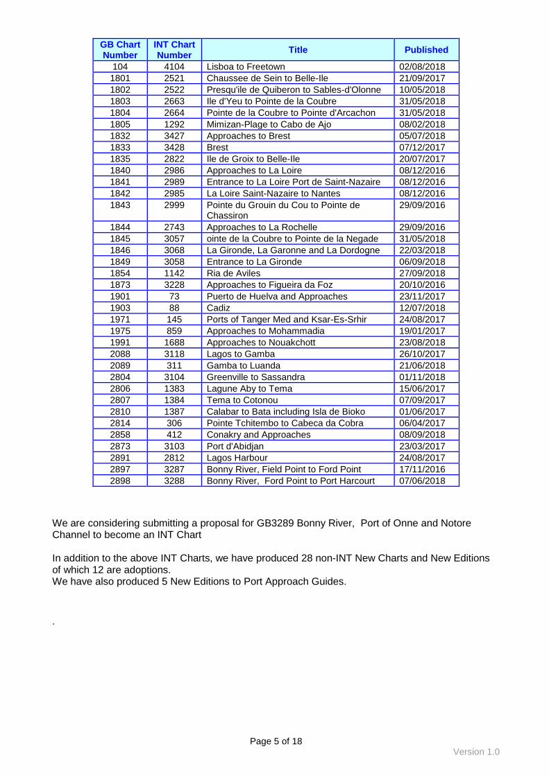
The following charts have been published since the last EAtHC meeting as New Charts or New Editions:
Page 5 of 18
Version 1.0
GB Chart Number
INT Chart Number
Title Published
104 4104 Lisboa to Freetown 02/08/2018
1801 2521 Chaussee de Sein to Belle-Ile 21/09/2017
1802 2522 Presqu'ile de Quiberon to Sables-d'Olonne 10/05/2018
1803 2663 Ile d'Yeu to Pointe de la Coubre 31/05/2018
1804 2664 Pointe de la Coubre to Pointe d'Arcachon 31/05/2018
1805 1292 Mimizan-Plage to Cabo de Ajo 08/02/2018
1832 3427 Approaches to Brest 05/07/2018
1833 3428 Brest 07/12/2017
1835 2822 Ile de Groix to Belle-Ile 20/07/2017
1840 2986 Approaches to La Loire 08/12/2016
1841 2989 Entrance to La Loire Port de Saint-Nazaire 08/12/2016
1842 2985 La Loire Saint-Nazaire to Nantes 08/12/2016
1843 2999 Pointe du Grouin du Cou to Pointe de Chassiron
29/09/2016
1844 2743 Approaches to La Rochelle 29/09/2016
1845 3057 ointe de la Coubre to Pointe de la Negade 31/05/2018
1846 3068 La Gironde, La Garonne and La Dordogne 22/03/2018
1849 3058 Entrance to La Gironde 06/09/2018
1854 1142 Ria de Aviles 27/09/2018
1873 3228 Approaches to Figueira da Foz 20/10/2016
1901 73 Puerto de Huelva and Approaches 23/11/2017
1903 88 Cadiz 12/07/2018
1971 145 Ports of Tanger Med and Ksar-Es-Srhir 24/08/2017
1975 859 Approaches to Mohammadia 19/01/2017
1991 1688 Approaches to Nouakchott 23/08/2018
2088 3118 Lagos to Gamba 26/10/2017
2089 311 Gamba to Luanda 21/06/2018
2804 3104 Greenville to Sassandra 01/11/2018
2806 1383 Lagune Aby to Tema 15/06/2017
2807 1384 Tema to Cotonou 07/09/2017
2810 1387 Calabar to Bata including Isla de Bioko 01/06/2017
2814 306 Pointe Tchitembo to Cabeca da Cobra 06/04/2017
2858 412 Conakry and Approaches 08/09/2018
2873 3103 Port d'Abidjan 23/03/2017
2891 2812 Lagos Harbour 24/08/2017
2897 3287 Bonny River, Field Point to Ford Point 17/11/2016
2898 3288 Bonny River, Ford Point to Port Harcourt 07/06/2018
We are considering submitting a proposal for GB3289 Bonny River, Port of Onne and Notore Channel to become an INT Chart In addition to the above INT Charts, we have produced 28 non-INT New Charts and New Editions of which 12 are adoptions. We have also produced 5 New Editions to Port Approach Guides.
.

Page 6 of 18
Version 1.0
3.3 As noted in section 3.1, UK’s Generic National Report provides information on UK’s portfolio of chart products and services. The following paragraphs provide information specifically relevant to the EAtHC region.
ENCs
3.4 Within the EAtHC region, the UKHO has released a total of 82 ENC cells. The breakdown by usage band is shown in the table below:
EAtHC Region Released Cells ENC Usage Band Number of GB ENCs Comment
Overview 5 Includes part cells
General 1
Coastal 28
Approach 23
Harbour 21
Berthing 4
Total number of released ENCs
82
ENC totals by usage band as produced by UKHO
The diagrams overleaf show the current status of GB ENC’s within the EAtHC Region. This is an increase of 2 cells since the last EAtHC meeting and is a result of interim GB cells being replaced by French and Portuguese cells and the conflagration of the UKHO database.
ENC Distribution
3.5 The UKHO, along with other European hydrographic offices, was a founder member of the IC-ENC RENC. IC-ENC (International Centre for ENCs) concentrates its efforts on the validation and consistency of ENC data and leaves the marketing of ENCs to the shipping industry to its value-added resellers and chart agents. Additional details can be found on the IC-ENC website (www.ic-enc.org). UKHO recently clarified its responsibility for the operation of IC-ENC with revisions to the IC-ENC Cooperation Arrangement. This was discussed with IC-ENC members at its Steering Committee in July 2018.
The UKHO also acts as a VAR in its own right, particularly promoting a global range of ENCs under the AVCS brand alongside its successful Admiralty range of paper charts and publications. Additional details can be found on the UKHO’s Admiralty website (www.admiralty.co.uk).
Digital Charts

Page 7 of 18
Version 1.0

Page 8 of 18
Version 1.0

Page 9 of 18
Version 1.0

Page 10 of 18
Version 1.0

Page 11 of 18
Version 1.0
4. PUBLICATIONS
4.1 The UKHO produces the following publications on an annual revision cycle within the EAtHC region:
• NP74 ADMIRALTY List of Lights and Fog Signals Vol. A. British Isles and North Coast of France.
• NP77 ADMIRALTY List of Lights and Fog Signals Vol. D Eastern Atlantic Ocean, Western Indian Ocean, Arabian & Red Seas
• NP201A ADMIRALTY Tide Tables Volume 1A: United Kingdom – English Channel to River Humber (including Isles of Scilly, Channel Islands and European Channel Ports)
• NP202 ADMIRALTY Tide Tables Volume 2: North Atlantic Ocean and Arctic Regions
• NP208 ADMIRALTY Tide Tables Volume 8: South East Atlantic Ocean, West Africa and Mediterranean (Paper product)
• NP281(1) ADMIRLATY List of Radio Signals Maritime Radio Stations Europe, Africa and Asia
• NP282(1) ADMIRALTY List of Radio Signals. Radio Aids to Navigation, Differential GPS (DGPS), Legal Time, Radio Time Signals and Electronic Position Fixing System Europe, Africa and Asia
• NP283(1) ADMIRALTY List of Radio Signals. Maritime Safety Information Services, Europe, Africa and Asia
• NP284 ADMIRALTY List of Radio Signals. Meteorological Observation Stations
• NP285 ADMIRALTY List of Radio Signals. Global Maritime Distress and Safety Systems (GMDSS)
• NP286(1) ADMIRALTY List of Radio Signals. Pilot Services, Vessel Traffic Services and Port Operations, United Kingdom and Europe
• NP286(3) ADMIRALTY List of Radio Signals. Pilot Services, Vessel Traffic Services and Port Operations, Mediterranean Sea, Black Sea, Caspian and Suez Canal
• NP286(8) ADMIRALTY List of Radio Signals. Pilot Services, Vessel Traffic Services and Port Operations, Africa (excluding Mediterranean Coast), Red Sea and the Persian Gulf
Full details of the ADMIRALTY publication range and their status can be found on the ADMIRALTY website https://www.admiralty.co.uk.
The UKHO produces the following publications on a three to five-year revision cycle within the EAtHC region:
Paper Publications

Page 12 of 18
Version 1.0
• NP1 Africa Pilot Volume 1 (2017 Edition)
• NP2 Africa Pilot Volume 2 (2017 Edition)
• NP22 Bay of Biscay Pilot (2016 Edition)
• NP27 Channel Pilot (2017 Edition)
• NP39 South Indian Ocean Pilot (2017 Edition)
• NP45 Mediterranean Pilot Volume 1 (2018 Edition)
• NP46 Mediterranean Pilot Volume 2 (2018 Edition)
• NP67 West Coasts of Spain and Portugal Pilot (2018 Edition
4.2 The UKHO offers digital equivalents to its existing paper publications to support the IMO mandate of ECDIS. These publications provide mariners with additional functionality and automate the task of updating.
4.3 The UKHO produces a range of ADMIRALTY Digital Publications which are digital versions of ADMIRALTY paper Nautical Publications. These publications are subscription-based and updatable by Notice to Mariners.
• ADMIRALTY e-Nautical Publications (AENP): e-Book versions of ADMIRALTY Sailing
Directions and reference publications.
• ADMIRALTY Digital List of Lights (ADLL): Digital versions of ADMIRALTY lights
publications.
• ADMIRALTY TotalTide (ATT): Digital versions of ADMIRALTY tidal publications.
• ADMIRALTY Digital Radio Signals (ADRS): Digital versions of ADMIRALTY radio signal
publications.
4.4 The ADMIRALTY Digital Catalogue (ADC) can be downloaded free from the
ADMIRALTY website (www.admiralty.co.uk). It includes details of all paper and digital charts and
publications and is updated weekly. It is a useful tool to check chart coverage within the region,
and to show the latest edition dates of both charts and publications.
5.1 The UK has no principal responsibility within the EAtHC region, but there are a number of countries where the United Kingdom is the producer of primary charting, these are The Gambia, Sierra Leone, Liberia, Ghana and Nigeria. UKHO provides assistance and advice to countries throughout EAtHC, as requested by any administration within those countries.
Digital Publications
5. MARITIME SAFETY INFORMATION

Page 13 of 18
Version 1.0
5.2 The UK has no principal responsibility within the EAtHC region, but there are a number of countries where the United Kingdom is the producer of primary charting, these are The Gambia, Sierra Leone, Liberia, Ghana and Nigeria. UKHO provides assistance and advice to countries throughout EAtHC, as requested by any administration within those countries.
5.3 There is a limited MSI broadcast within the EAtHC region by West African States. Whilst the International SafetyNET service has been in existence for many years, expansion of NAVTEX services are required, particularly to cover the area of West Central Africa. Liberia and Nigeria have applied to IMO NAVTEX Coordinating Panel for NAVTEX stations at Monrovia, Lagos and Oron respectively.
5.4 Notices to Mariners. Assistance with promulgating Notices to Mariners and other paper and electronic chart correcting material should also be encouraged through co-operation with other hydrographic offices in the region if required.
6. C-55 LATEST UPDATE
6.1 As described in the UK Generic National Report, the UKHO is committed to providing regular updates to the C-55 entries for UK Home Waters and its Overseas Territories. The latest status is correctly depicted within C-55.
6.2 UK has also provided assistance to update C-55 entries to other countries, including Gambia, Ghana, Liberia, Nigeria and Sierra Leone, where the UKHO is the producer of primary charting, recognising that local input remains critical to the maintenance of C-55 as an up-to-date and authoritative reference document.
7. CAPACITY BUILDING
7.1 The UK fully supports the IHO Capacity Building Sub-Committee (CBSC) strategy and
particularly its emphasis on getting Phase 1 and appropriate Phase 2 capacity in place to enable
coastal states to meet their obligations under SOLAS Chapter V Regulations 4 and 9. UK will
continue to contribute resources to both CBSC initiatives and to providing bilateral assistance.
7.2 In recognition of the importance of establishing Phase 1 capability throughout the region, UKHO has supported IHO technical visits to Gambia in 2017 and also Nigeria training centre in Port Harcourt in 2018.
7.3 UKHO has a post dedicated to International Training and Capacity Building. Its key aims
are to ensure that capacity building is properly considered in UKHO activity and that UKHO’s
capacity building activities are fully coordinated. It acts as the initial point of contact for UKHO
involvement in IHO capacity building activities, including UK involvement in regional hydrographic
commission initiatives and IHO Capacity Building Sub Committee (CBSC) activities. Further
information can be obtained from the International Training and Capacity Building Manager - Miss
Lucy Fieldhouse ([email protected]). Miss Lucy Fieldhouse is also the Capacity
Building Coordinator for the MACHC, SAIHC and NIOHC regions.
.
Page 14 of 18
Version 1.0
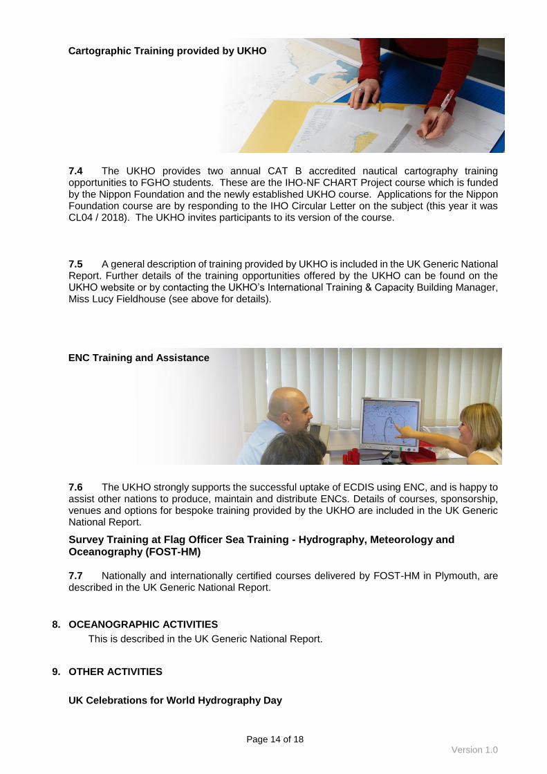
7.4 The UKHO provides two annual CAT B accredited nautical cartography training opportunities to FGHO students. These are the IHO-NF CHART Project course which is funded by the Nippon Foundation and the newly established UKHO course. Applications for the Nippon Foundation course are by responding to the IHO Circular Letter on the subject (this year it was CL04 / 2018). The UKHO invites participants to its version of the course.
7.5 A general description of training provided by UKHO is included in the UK Generic National Report. Further details of the training opportunities offered by the UKHO can be found on the UKHO website or by contacting the UKHO’s International Training & Capacity Building Manager, Miss Lucy Fieldhouse (see above for details).
7.6 The UKHO strongly supports the successful uptake of ECDIS using ENC, and is happy to assist other nations to produce, maintain and distribute ENCs. Details of courses, sponsorship, venues and options for bespoke training provided by the UKHO are included in the UK Generic National Report.
Survey Training at Flag Officer Sea Training - Hydrography, Meteorology and Oceanography (FOST-HM) 7.7 Nationally and internationally certified courses delivered by FOST-HM in Plymouth, are described in the UK Generic National Report.
8. OCEANOGRAPHIC ACTIVITIES
This is described in the UK Generic National Report.
9. OTHER ACTIVITIES
UK Celebrations for World Hydrography Day
Cartographic Training provided by UKHO
ENC Training and Assistance

Page 15 of 18
Version 1.0
9.1 Acknowledging the 2018 World Hydrography Day theme “Bathymetry - the foundation for sustainable seas, oceans and waterways”, UKHO hosted an interactive family day in June at the Museum of Somerset in Taunton, UK. This free to attend event was aimed at showing the local community the importance of hydrography and the vital role it plays in our lives. The event offered a range of maritime-themed activities for both children and adults, including navigating around obstacles by calculating depths, and an augmented reality sandbox showing bathymetry in action, with responsive contours projected onto the sand as it was moved and sculpted by visitors. The event was well attended by adults and children, giving them an opportunity to meet expert mariners and representatives from UKHO. 9.2 UKHO held a national celebration of World Hydrography in London in October 2018. Guests representing marine and maritime interests, including government policy makers, academia and scientists were invited to an evening reception at Trinity House, the headquarters of England’s Lighthouse Authority. This event explores the importance of hydrography and our knowledge of the shape, nature and depth of the seafloor as a fundamental requirement for the proper, safe, sustainable and cost-effective use of the world's seas, oceans and waterways. This year our annual World Hydrography event coincided with the IHO’s 2nd Meeting of the IHO Council taking place in London. UKHO welcomed IHO Council members to this event which included the presentation of the Alexander Dalrymple Award to Mr Jeff Bryant in recognition of his outstanding dedication and contribution to hydrography. This annual award established by the UKHO is named in honour of Alexander Dalrymple FRS, who, following orders from King George III in 1795, set up what is now the UK Hydrographic Office.
Broader UK Government Work
9.3 Blue Belt Programme In support of the UN Global Goals for Sustainable Development, the UK Government has committed £20 million to a four year programme providing long term protection and sustainable management of over four million square kilometres of marine environment across the UK Overseas Territories.
The Blue Belt Programme supports delivery of the UK Government’s manifesto commitment to provide long term protection of:
• improve scientific understanding of the marine environment
• develop and implement evidence based, tailored marine management strategies including surveillance and enforcement
• ensure management is sustainable and long term The programme is being delivered in partnership between the Centre for Environment, Fisheries and Aquaculture Science (Cefas) and the Marine Management Organisation (MMO) with the UK Overseas Territories on behalf of the Foreign and Commonwealth Office and the Department for Environment, Food and Rural Affairs.
The main focus has been working with local government to improve marine management and using technologies such as near real-time analysis of satellite data for targeted enforcement of illegal, unreported and unregulated (IUU) fishing. One of UKHO’s surveyors joined the Blue Belt team onboard the British Antarctic Survey’s marine research vessel RRS James Clark Ross, to collect and process bathymetry data covering seamounts around Tristan da Cunha and St Helena. This enabled marine ecologists to better understand the marine habitats at important fishing areas.
Commonwealth Nations
9.4 The UK is the current chair of the Commonwealth Heads of Government Meeting (CHOGM18), which was held between the 16th and 21st April, in London. The next CHOGM will be in 2020, and the UKHO has demonstrated its commitment to furthering the Commonwealth’s Blue Charter aspirations by announcing funding for a number of innitiatives including continued support to the CME Prog.

Page 16 of 18
Version 1.0
The UKHO continues to take a leading role in pushing ocean’s policy within government and is working on a number of initiatives that should see continued focus on seabed mapping for the commonwealth and beyond.
UKHO’s International Activities
9.5 Due to UKHO’s technical expertise, primary charting responsibilities and UK OTs the UK is represented at the following groups:
International Hydrographic Organisation - HSSC Chair/Vice
Chair Member
DQWG Data Quality Working Group x
ENCWG ENC Standards Maintenance Working Group x x
HSSC Hydrographic Services and Standards Committee x
NCWG Nautical Cartography Working Group x
NIPWG Nautical Information Provision Working Group x x
S-100WG S-100 Working Group x
TWCWG Tides, Water Level & Currents Working Group x
International Hydrographic Organisation - IRCC Chair/Vice
Chair Member
CBSC Capacity Building Sub-Committee x
CSBWG Crowd-sourced Bathymetry Working Group x
DRWG Document Review Working Group of NAVTXT x
HCA Hydrographic Commission on Antarctica x
IRCC Inter-Regional Coordination Committee x
MACHC Meso American and Caribbean Sea Hydrographic
Commission
x
MBSHC Mediterranean and Black Seas Hydrographic
Commission
x
MSDIWG Marine Spatial Data Infrastructure Working Group x
NIOHC North Indian Ocean Hydrographic Commission x x
NSHC North Sea Hydrographic Commission x
RSAHC ROPME Sea Area Hydrographic Commission x
SAIHC Southern African and Islands Hydrographic
Commission
x x
SWPHC South-West Pacific Hydrographic Commission x
WENDWG Worldwide ENC Database Working Group x x
WWNWS Worldwide Navigational Warning Service x
International Maritime Organisation Chair/Vice
Chair Member
NAVTEX NAVTXT Coordination panel x x
International Association of Marine Aids to Navigation and
Lighthouse Authorities Chair/Vice
Chair Member
ENAV E-navigation Committee x
Other International Bodies Chair/Vice
Chair Member
IAU International Astronomical Union x
CIRM Comité International Radio-Maritime x
BALTICO Navarea1 member states meeting x
ISO International Standards Organisation x
OGC Open Geospatial Consortium x x

Page 17 of 18
Version 1.0
10. CONCLUSION
10.1 UK has a strong commitment to the East Atlantic region, through its primary charting activity, its continuing interest in developing regional hydrographic self-sufficiency through capacity building measures and more recently through its work to review the status of hydrography within the UK Overseas Territories and its commitment to the Commonwealth Marine Economies (CME) programme.
10.2 The UK, through the UKHO and the national maritime administration (Maritime Coastguard Agency), continues to pursue opportunities to improve access to bathymetric data gathering in waters around UK Overseas Territories, particularly to support long-haul deep-sea traffic.
10.3 There is a continuing challenge to link the scarce local data gathering resources into a broad programme of prioritised chart compilations and new editions.
10.4 The provision of adequate ENC coverage, in support of the IMO carriage requirement for ECDIS concluded in July 2018, which presents a challenge in the EAtHC region as well as other regions.
10.5 With a diverse range of shipping interests in the region, improving the effective distribution of hydrographic publications and updates remains paramount.
Taunton, October 2018

Page 18 of 18
Version 1.0
UKHO POINTS OF CONTACT
UKHO Website: GOV.uk/UKHO
The general UKHO address is:
UK Hydrographic Office, Admiralty Way, TAUNTON Somerset TA1 2DN United Kingdom
E-mail: [email protected] Telephone: +44 (0)1823 484444
For further information on this report, UKHO representation in international fora, and UKHO activities in general, please contact:
For bilateral arrangements and other international partnering matters within the SAIHC region, please contact: Mr Chris Thorne, Head of Partnering & Engagement (east Atlantic & Caribbean) Telephone: +44 (0) 1823 483933 Mobile: +44 (0) 7788190582
E-mail: [email protected]
Miss Lucy Fieldhouse Head of International Programmes and Training Telephone: +44 (0)1823 484444 Mobile: +44 (0) 7989152246 E-mail: [email protected]
For charting matters in the EAtHC region, please contact: Miss Cathy Tunks, Geographic Technical Manager E-mail: [email protected] Telephone: +44 (0)1823 483956
For matters related to Sailing Directions within the EAtHC, please contact: Mr Paul Hardacre E-mail: [email protected] Telephone: +44 (0)1823 483427


