
Www.gcad-cymru.org.uk Movement Movement Movement Movement Movement Movement.

NATURAL RESOURCES
Natural resources are useful raw materials that we get from the Earth. Everything available in our environment which can be used to satisfy our needs provided it is technologically accessible, economically feasible and culturally acceptable can be termed as ‘RESOURCE’.
Examples: coal, minerals, soil, water, etc.They occur naturally, which means that humans cannot make natural resources. Instead, we use and modify natural resources in ways that are beneficial to us. The materials used in human-made objects are natural resources. Some examples of natural resources and the ways we can use them are.
Classification
UNIT II - NATURAL
RESOURCES: PROBLEMS
AND PROSPECTS
Bharati Vidyapeeth’s College of Engineering, New Delhi
2019 Notes compiled by the Teachers
1
1
FOREST RESOURCES
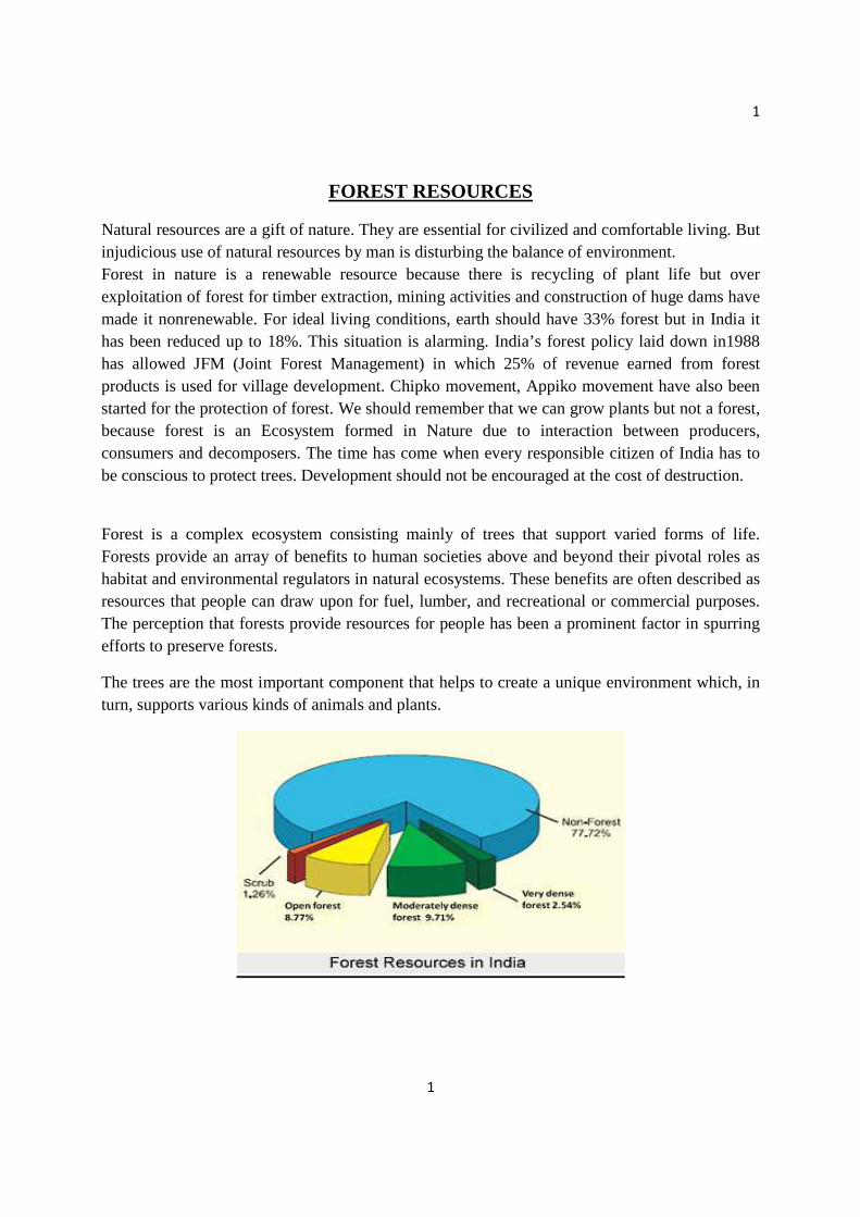
Natural resources are a gift of nature. They are essential for civilized and comfortable living. But injudicious use of natural resources by man is disturbing the balance of environment. Forest in nature is a renewable resource because there is recycling of plant life but over exploitation of forest for timber extraction, mining activities and construction of huge dams have made it nonrenewable. For ideal living conditions, earth should have 33% forest but in India it has been reduced up to 18%. This situation is alarming. India’s forest policy laid down in1988 has allowed JFM (Joint Forest Management) in which 25% of revenue earned from forest products is used for village development. Chipko movement, Appiko movement have also been started for the protection of forest. We should remember that we can grow plants but not a forest, because forest is an Ecosystem formed in Nature due to interaction between producers, consumers and decomposers. The time has come when every responsible citizen of India has to be conscious to protect trees. Development should not be encouraged at the cost of destruction.
Forest is a complex ecosystem consisting mainly of trees that support varied forms of life. Forests provide an array of benefits to human societies above and beyond their pivotal roles as habitat and environmental regulators in natural ecosystems. These benefits are often described as resources that people can draw upon for fuel, lumber, and recreational or commercial purposes. The perception that forests provide resources for people has been a prominent factor in spurring efforts to preserve forests.
The trees are the most important component that helps to create a unique environment which, in turn, supports various kinds of animals and plants.
2
2
CLASSFICATION OF FORESTS
Forests can be classified on the basis of
1. Age 2. Method of regeneration 3. Composition 4. Ownership 5. Object of Management 6. Growing Stock
Classification of Forest On the Basis of Age:
A) Even Aged Forest:
Even-aged forests, also called regular forests are those consisting of even - aged woods. Even - aged wood means trees of approximately the same age.
B) Un-Even Aged Forests:
A forest is called uneven - aged or irregular when trees vary widely in age.
Classification of Forest On the Basis of Regeneration:
A) High Forest: When regeneration is obtained from seed.
B) Coppice Forest: When regeneration is through coppice or some vegetative part of the tree.
1. Natural Forest: When the regeneration is obtained naturally, therefore are called natural forests.
2. Man Made Forest: When it is obtained artificially, the forests are called Man-made forests or Plantations.
Classification of Forest On the Basis of Composition:
A. Pure Forests: Pure forests are composed almost entirely of one species, usually to the extent of not less than 50 percent.
B. Mixed Forests: Mixed forests are defined as forest composed of trees of two or more species intermingled in the same canopy.
Oak, Maple are the species found here.
Classification of Forest On the Basis of Ownership:
A). Government Forests: Hanumasagara reserve forest in Karnataka

3
3
a. Reserved Forests: Palani Hills forest conservation area in Tamil nadu
b. Protected Forests:
c. Village Forests: A Village forest is a state forest assigned to a village community under the provisions of chapter III of Indian Forest Act.
B). Private Forests
Forests owned by Corporations, Panchayats, Societies and other Agencies.
Classification of Forest On the Basis of Management:
A. Protection Forests: Protection forests are those which are managed primarily for ameliorating climate, checking soil erosion and floods, conserving soil and water, regulating stream flow and increasing water yields and exerting other beneficial influences.
B. Production Forests: Production forests are those which are managed primarily for their produce.
C. Social Forests: Social forests where the produce is utilized by neighboring society.
Classification of Forest On the Basis of Growing Stock:
A. Normal Forest: A normal forest is an ideal forest with regard to growing stock, age class distribution. Maple, and Mosses and Ferns are common here.
B. Abnormal Forest: Abnormal forest is one which is not normal, i.e. growing stock, age, class, distribution of stems, increment, etc. Kauri tree, Vegetable sheep are few of the trees found in these forests in New Zealand.
IMPORTANCE OF FORESTS
1. Ecological importance
• Reduction of Global Warming Gas – During photosynthesis, plants synthesis their nutrients from carbon dioxide and water. So, plants help to reduce a global warming causing gas from the atmosphere that is CO2. Therefore, forests act as a sink for this gas and thereby reducing green house effect due to Carbon Dioxide.
• Production of Oxygen – During photosynthesis process, trees produce oxygen gas which is very important for human survival.
4
4
• Habitat to Wild Life – Forests act as a refuge for wild animals and provide protection to them against strong, cold, or hot and dry winds, solar radiations, rain and enemies.
• Control of Water Flow – The forests act as a great sponge. They slow down
runoff, absorbing and holding water that recharges springs, streams and ground water.
• Conservation of Soil – They prevent soil erosion by binding the soil particles
tightly in their roots. They also reduce the velocity of wind and rain which chief agents are causing erosion. The litter derived from fallen leaves maintains fertility of the soil by returning the nutrients in form of humus.
2. Economic importance
• Role of Forests in Economic Development of a Country - Forests play an
important role in the economic development of a country. They provide several goods which serve as raw materials for many industries. Wood grown in forests serves as a source of energy for rural households.
• Paper Industry - Most of the world’s paper is made from wood and one rather reliable index to the degree of economic development of a country is its per capita consumption of paper. As an economy develops economically, paper is used as packaging material, in communications and in scores of other uses. No really satisfactory substitute for paper exists for many of its uses.
• Timber- Given the immense economic benefit of forests, the demand for commercial timber and other product is ever increasing.
3. Economical importance
• Fuel and Fodder- Even more important is fuel wood and fodder, especially in developing nations, where people depend on wood almost entirely for their household energy
• Recreation - Forests serve people directly for recreation. Biosphere reserves are
multipurpose protected areas created to deal with conservation of bio-diversity and its sustainable use. In biosphere reserves local area resources are developed. Agricultural activities are allowed to the local communities and employment is
5
5
provided to the people. Tourism in parks, sanctuaries and biosphere reserves brings revenue to the authorities that manage them.
• Non-timber products- Forests play many roles in the economic development of a country in addition to providing wood fiber for many uses, the non-wood outputs of forests are coming increasingly to be recognized and valued everywhere in the world. Non-timber products like rubber, cotton, medicinal products, and food represent economic value.
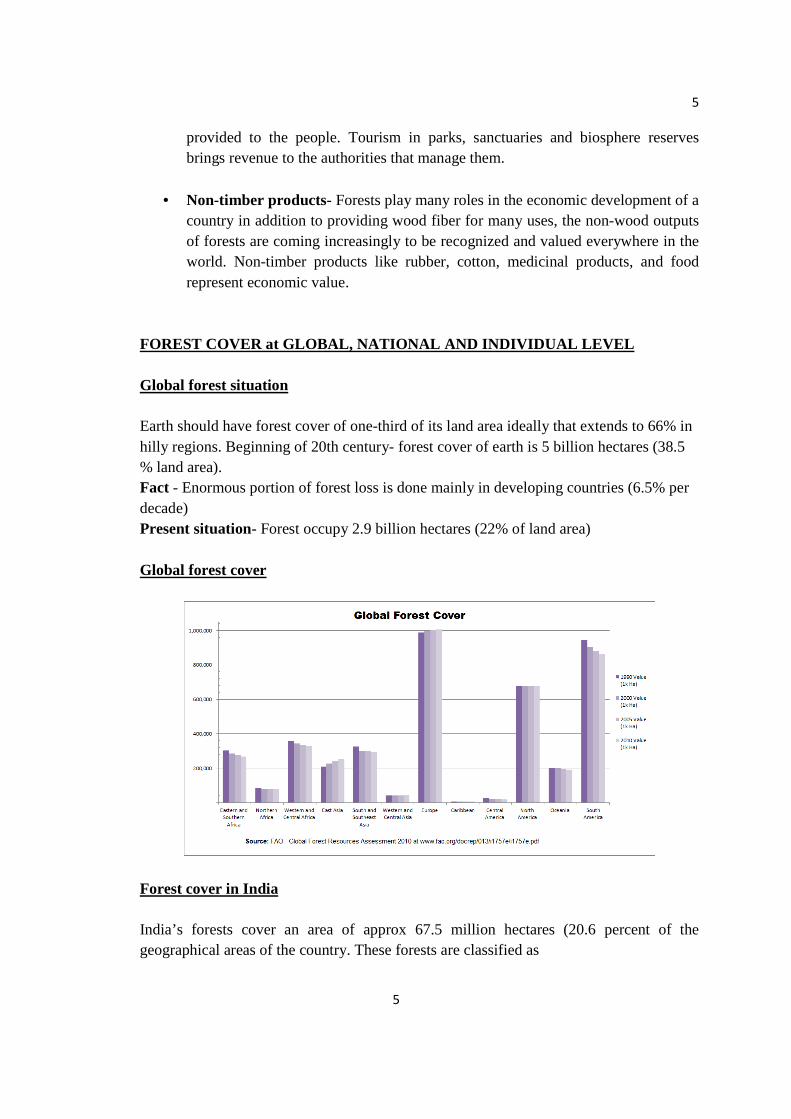
FOREST COVER at GLOBAL, NATIONAL AND INDIVIDUAL LEV EL Global forest situation Earth should have forest cover of one-third of its land area ideally that extends to 66% in hilly regions. Beginning of 20th century- forest cover of earth is 5 billion hectares (38.5 % land area).
Fact - Enormous portion of forest loss is done mainly in developing countries (6.5% per decade) Present situation- Forest occupy 2.9 billion hectares (22% of land area) Global forest cover
Forest cover in India India’s forests cover an area of approx 67.5 million hectares (20.6 percent of the geographical areas of the country. These forests are classified as
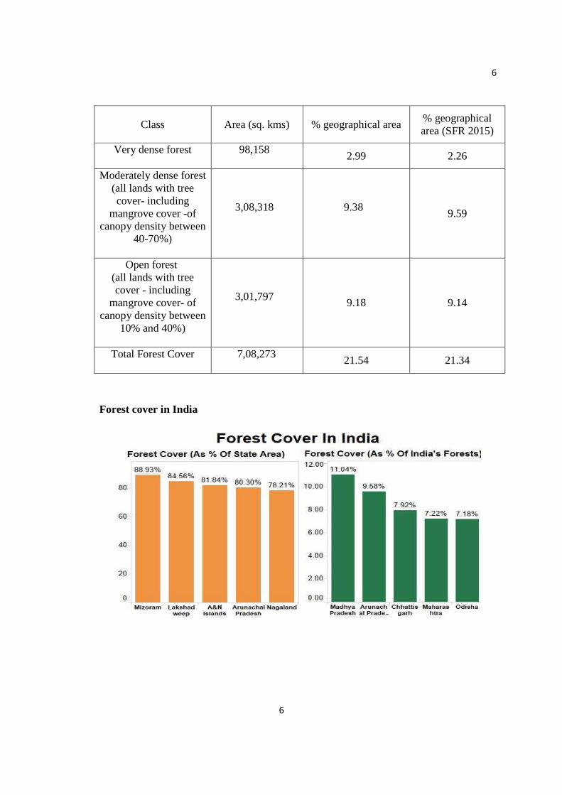
6
6
Class Area (sq. kms) % geographical area % geographical area (SFR 2015)
Very dense forest
98,158
2.99 2.26
Moderately dense forest (all lands with tree cover- including
mangrove cover -of canopy density between
40-70%)
3,08,318
9.38
9.59
Open forest (all lands with tree cover - including
mangrove cover- of canopy density between
10% and 40%)
3,01,797
9.18 9.14
Total Forest Cover
7,08,273
21.54 21.34
Forest cover in India
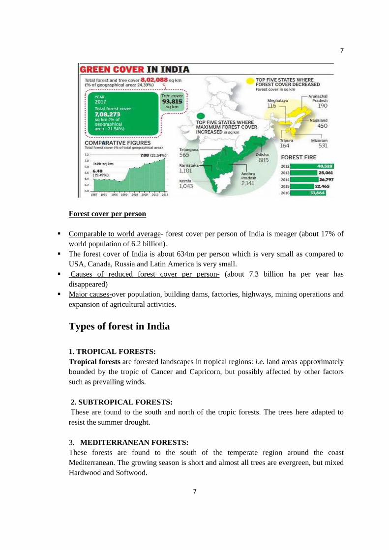
7
7
Forest cover per person
Comparable to world average- forest cover per person of India is meager (about 17% of world population of 6.2 billion).
The forest cover of India is about 634m per person which is very small as compared to USA, Canada, Russia and Latin America is very small.
Causes of reduced forest cover per person- (about 7.3 billion ha per year has disappeared)
Major causes-over population, building dams, factories, highways, mining operations and expansion of agricultural activities.
Types of forest in India 1. TROPICAL FORESTS: Tropical forests are forested landscapes in tropical regions: i.e. land areas approximately bounded by the tropic of Cancer and Capricorn, but possibly affected by other factors such as prevailing winds. 2. SUBTROPICAL FORESTS: These are found to the south and north of the tropic forests. The trees here adapted to resist the summer drought. 3. MEDITERRANEAN FORESTS: These forests are found to the south of the temperate region around the coast Mediterranean. The growing season is short and almost all trees are evergreen, but mixed Hardwood and Softwood.

8
8
4. MANGROVE FOREST A mangrove is a shrub or small tree that grows in coastal saline or brackish water. The term is also used for tropical coastal vegetation consisting of such species. According to a status report of the Government of India publication, the total area of the mangroves in India, was reckoned at about 6,740 km2. This covered about 7% of the world mangroves and 8% of the Indian coastline .But a recent Indian Remote Sensing Data showed that the total area of the mangroves decreased to 4,474 km2. Mangroves are found in Andhra Pradesh, Goa, Kerala, Karnataka, Tamil Nadu, Daman and Diu, with dense cover in West Bengal and Andaman And Nicobar Islands. 5. TEMPERATE FORESTS : A temperate forest is a forest found between the tropics and polar region in the area of the earth with the widest seasonal changes, the temperate zone. They fall into one of several main types: deciduous, coniferous, broadleaf and mixed forest and rainforest. 6. CONIFEROUS FORESTS : Coniferous forest, vegetation composed primarily of cone-bearing needle-leaved or scale-leaved evergreen trees, found in areas that have long winters and moderate to high annual precipitation. The northern Eurasian coniferous forest is called the taiga, or the boreal forest. 7. MONTANE FORESTS : The elevation of the montane forests life zone is from about 8,000 to 10,000 ft. above sea level. You can tell that you are getting higher in the mountains by the cooler temperatures, the dense mountain forests, and by the increased precipitation throughout the year. DEFORESTATION It can be defined as the removal or damage of vegetation in a forest to the extent that it no longer supports its natural flora and fauna. In the beginning of 20th century about 7.0 billion hectares of forests were present over the land of our planet and by 1950 forest covers was reduced to about 4.8 billion. In a FAQ/UNEP study it was found that about 7.3 million hectares of rich tropical forests every year and about 14 hectare of closed forest every minute are lost.
9
9
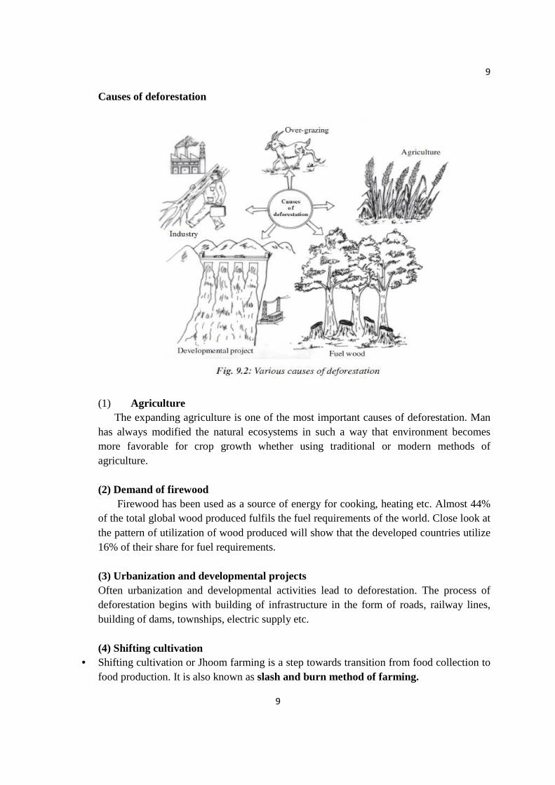
Causes of deforestation
(1) Agriculture The expanding agriculture is one of the most important causes of deforestation. Man has always modified the natural ecosystems in such a way that environment becomes more favorable for crop growth whether using traditional or modern methods of agriculture. (2) Demand of firewood Firewood has been used as a source of energy for cooking, heating etc. Almost 44% of the total global wood produced fulfils the fuel requirements of the world. Close look at the pattern of utilization of wood produced will show that the developed countries utilize 16% of their share for fuel requirements. (3) Urbanization and developmental projects Often urbanization and developmental activities lead to deforestation. The process of deforestation begins with building of infrastructure in the form of roads, railway lines, building of dams, townships, electric supply etc. (4) Shifting cultivation
• Shifting cultivation or Jhoom farming is a step towards transition from food collection to food production. It is also known as slash and burn method of farming.
10
10
• Annually about 5 lakhs hectares of forest is cleared for this type of farming. This method of cultivation causes extreme deforestation.
• Practiced in the states of Assam, Manipur, Meghalaya, Mizoram, Nagaland, Tripura and Andaman and Nicobar Islands. (5) Wood for industry and commercial use
• Wood, the versatile forest produce, is used for several industrial purposes, such as making crates, packing cases, furniture, match boxes, wooden boxes, paper and pulp, plywood, etc.
• 1.24 lakh ha of forest have been cut for various industrial uses. EFFECTS OF DEFORESTATION 1. Loss of Habitat
One of the most dangerous and unsettling effects of deforestation is the loss of animal and plant species due to their loss of habitat; not only do we lose those known to us, but also those unknown, potentially an even greater loss. "Seventy percent of Earth's land animals and plants live in a forest, and many cannot survive the deforestation that destroys their homes." The trees of the rainforest that provide shelter for some species also provide the canopy that regulates the temperature, a necessity for many others. Its removal through deforestation would allow a more drastic temperature variation from day to night, much like a desert, which could prove fatal for current inhabitants.
2. Increased Greenhouse Gases In addition to the loss of habitat, the lack of trees also allows a greater amount of greenhouse gases to be released into the atmosphere. Presently, the tropical rainforests of South America are responsible for 20% of Earth's oxygen and they are disappearing at a rate of 4 hectares a decades. If these rates are not stopped and reversed, the consequences will become even more severe.

11
11
3. Water in the Atmosphere
The trees also help control the level of water in the atmosphere by helping to regulate the water cycle. With fewer trees left, due to deforestation, there is less water in the air to be returned to the soil. In turn, this causes dryer soil and the inability to grow crops, an ironic twist when considered against the fact that 80% of deforestation comes from small-scale agriculture and cattle ranching.
4. Soil Erosion Further effects of deforestation include soil erosion and coastal flooding. In addition to their previously mentioned roles, trees also function to retain water and topsoil, which provides the rich nutrients to sustain additional forest life. Without them, the soil erodes and washes away, causing farmers to move on and perpetuate the cycle. The barren land which is left behind in the wake of these

12
12
unsustainable agricultural practices is then more susceptible to flooding, specifically in coastal regions. “Coastal vegetation lessens the impact of waves and winds associated with a storm surge. Without this vegetation, coastal villages are susceptible to damaging floods.”
5. Destruction of Homelands As large amounts of forests are cleared away, allowing exposed earth to wither and die and the habitats of innumerable species to be destroyed, the indigenous tribes who depend on them to sustain their way of life are also irreparably damaged. The loss of forests has an immediate and direct effect on their lifestyle that we in the modern world, despite our own dependency on what the rainforest provides, will never know. The level of immediacy is exponentially greater. The governments of nations with rainforests in their borders also attempt to evict indigenous tribes, and often succeed, before the actual clear-cutting begins. One of the pre-emptive effects of deforestation
6. Some more effects of deforestation are • Loss of cultural and biodiversity
• Increase in pollution due to burning of wood and due to reduction in carbon dioxide fixing by plants • Decrease in availability of forest products.
• Local and Global climate changes: The rainfall pattern is affected as the forest is cut down. Local and global climatic changes may result from deforestation. • More floods and droughts: Because of deforestation, there is no regulation of the flow into rivers. As a result, floods and droughts alternate in the affected areas. • Harm to fisheries: As the soil is eroded, it accelerates siltation in dams, rivers, and the coastal zone. The increased sedimentation harms downstream fisheries.
TIMBER EXTRACTION
• Wood used for engineering purposes like building houses, making furniture etc. is called as timber. The products derived from Timber have been important to many civilizations, and thus it has acquired value within these civilizations. There has always existed a powerful incentive for individuals to capture the wood value of old growth timber. Timber Extraction (LOGGING)
– The activity or business of felling trees and cutting and preparing the timber. – Illegal logging refers to what in forestry might be called timber theft by the timber
mafia. It can also refer to the harvesting, transportation, purchase, or sale of timber in violation of laws. The harvesting procedure itself may be illegal, including using corrupt
13
13
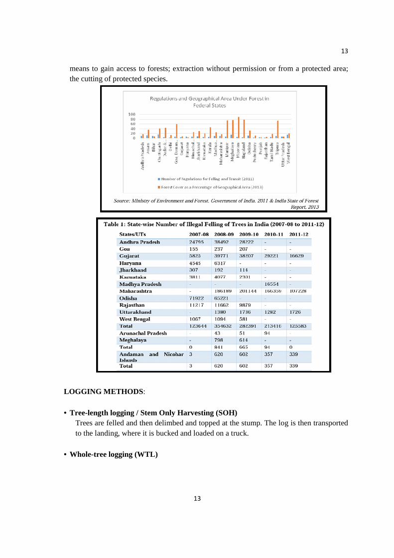
means to gain access to forests; extraction without permission or from a protected area; the cutting of protected species.
LOGGING METHODS :
• Tree-length logging / Stem Only Harvesting (SOH) Trees are felled and then delimbed and topped at the stump. The log is then transported to the landing, where it is bucked and loaded on a truck.
• Whole-tree logging (WTL)

14
14
Trees and plants are felled and transported to the roadside with top and limbs intact. There have been advancements to the process which now allows a logger or harvester to cut the tree down, top, and delimb a tree in the same process.
Impacts of logging
• Removal of forest covers directly leads to loss of animal habitat. Decline in animal diversity.
• Loss of watershed moderation. • Increased spring runoff • Summer droughts, soil destabilization. • Local microclimate attenuation.
Three unintended Impacts of Timber Extraction on Environment
• Loss of biodiversity • Loss of cultural diversity • Loss of carbon storage capacity
DAMS AND THEIR EFFECTS ON TRIBAL LIFE
o A dam is a huge and giant barrier constructed across a river to obstruct its natural flow. Consequently, an enormously large artificial lake is created to store water.
o Reservoirs created by dams not only suppress floods but also is utilized for multipurpose services such as –
1. POWER GENERATION, 2. IRRIGATION, 3. DROUGHT CONTROL, etc.
EFFECTS OF DAMS ON TRIBAL PEOPLE
1. No Home – Tribal people have been forced to leave their ancestral homes and go elsewhere. 2. No Basic Amenties – They are forced to migrate to urban slums in search of food, shelter, etc. They become landless labourers in rural areas. A majority of tribal people end up with less income before, fewer resources, inferior houses, etc. They are forced live without proper sanitation, health care and other basic amenities. 3. No Benefit Sharing –

15
15
They hardly get to share the benefits of development projects that cause their displacement. Moreover, they do not get money for their land by the government. 4. No Cultural Identity – Tribal communities get dispersed, their traditional support systems get broken and cultural identity gets devaluated. 5. No Human Rights – Human rights violations create unrest among tribals. EFFECTS OF DAMS ON FORESTS 1. Irrecoverable Loss To Ecosystems And Biodiversity – Forest fragmentation causes serious irrecoverable loss of species and ecosystems. This is because some species of plants and animals require large continuous area of similar habitat to survive. 2. Forests Area – The forests area which is supposed to get submerged is cleared off by the contractors and the forests land is used for constructing dams. 3. The forests are also cleared for approach roads, offices, residential quarters and for
storage of construction materials. 4. With the reduction in the forests cover and the entry of people of dam construction,
the pressure on remaining forest increases. 5. As more and more workers occupy the dam sites, forests are destroyed for getting
fuel and timber.
MINING AND ITS EFFECT
Mining is the extraction of valuable minerals or other geological materials from the earth, usually from an ore body.
Minerals recovered by mining include bauxite, coal, diamond, iron, precious metals, lead, limestone, nickel, phosphate, rock salt, tin, uranium and molybdenum.
HISTORY- The oldest known mine in the archaeological record is the “lion cave” in Swaziland which is 43,000 years old. Types of mining methods
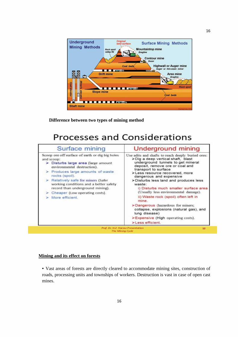
16
16
Difference between two types of mining method
Mining and its effect on forests
• Vast areas of forests are directly cleared to accommodate mining sites, construction of roads, processing units and townships of workers. Destruction is vast in case of open cast mines.
17
17
• Forest land is also used to store the waste materials that remain after the extraction of usable ores. • Mining also facilitates soil erosion, thereby decreasing the fertility of land leading to land degradation. • Pollution of both air and water is a common affect of mining process. FOREST CONSERVATION
– Forest conservation is the practice of planning and maintaining forested areas for the benefit and sustainability of future generations. Major Environmental Movements in India include:-
1. BISHNOI MOVEMENT -- Leader: Amrita Devi 2. CHIPKO MOVEMENT -- Leader: Sundarlal Bahuguna 3. JUNGLE BACHAO ANDHOLAN -- Leaders: The tribals of Singhbhum
FOREST MANAGEMENT A forest management system is a process in which forests are tended, harvested and regenerated. The biological characteristics of the forest being managed help to determine the appropriate forest management system.
Measures to conserve forests
• Afforestation: It is a proactive method used to improve forests. Afforestation is the planting of trees for commercial purposes.
• Reforestation: Reforestation is a method of planting trees in an existing forested area. This method is used in reaction to deforestation.
• Selective Logging: Selective logging is another method used to meet the needs of both the forests and humans seeking economical resources. Selective logging is the removal of trees within a stand based on size limitations
• Controlled Burn: Although it can be threatening if it is not controlled, fire is a successful way to conserve forest resources. Controlled burn is a technique that is used to manage forests. Fire can be highly beneficial to the ecosystems within a forest
• Proper utilization of forests and forest products • Forestry should be improved by modern techniques
Preventive measures taken By Central and State Government
Agro-forestry Social forestry Urban forestry
18
18
FOREST POLICY OF INDIA During the British rule the govt. didn’t show any concern about the protection of forest.
In 1952 Govt. of India framed a policy that one third of area of India should have forest cover. Up to 1988 this very policy was repeated again but this goal could not be achieved. The result is that forest area has depleted almost 18%.
JOINT FOREST MANAGAMENT (JFM) Joint Forest Management often abbreviated as JFM is the official and popular term in India for partnerships in forest movement involving both the state forest departments and local communities. The policies and objectives of Joint Forest Movement are detailed in the Indian comprehensive National Forest Policy of 1988 and the Joint Forest Management Guidelines of 1990 of the Government of India. Although schemes vary from state to state and are known by different names in different Indian languages, usually a village committee known as the Forest Protection Committee (FPC) and the Forest Department enter into a JFM agreement. Villagers agree to assist in the safeguarding of forest resources through protection from fire, grazing, and illegal harvesting in exchange for which they receive non-timber forest products and a share of the revenue from the sale of timber products. Joint Forest Management in India is an attempt to reserve the process of forest degradation on one hand, and to meet people's need on the other. Initially, the growth of JFM was slow during first initial decade. The MOEF revised JFM guidelines in 2000 and 2002 and circulate these guidelines among all states and union territories with sharpen focus on extending JFM program to good forest with very well defined institutional and legal framework. As on 2011, 1,18,213 Joint Forest Management Committee's have been managing approximately 22.93 million ha. of forestland that is 30 percent of forests. Forest user communities across the country have been dependent on forests for fuel wood, fodder, small timber and NTFPS for their basic needs. Under the JFM programmed these communities play a special role as they have been provided access to forest produce including NTFPs to meet their basic needs in lieu of protecting, regenerating, and maintain forest in collaboration with forest department. The success of JFM in India over the past two decades has been attributed to many factors like the leadership provided by the foresters and the communities, cultural and ethnic strength of the local population, quality and type of forests, socioeconomic profile of the people and level of degradation witnessed. JFM movement has been successful with varying degree of success largely due to felt need for conservation and the core items in implementation of various government schemes and programes like entry point activities. The JFMCs have proved immensely beneficial in generating income and empowering the women and other weaker and marginalized sections of the society.

19
19
Impact of JFM in Haryana
Major impacts are as followed Change in number of trees NTFP Harvesting Availability of NTFPs Employment and Out-Migration Change in Number of Species etc.
Achievements of Haryana Most of the forests in the Joint Forest Management Communities (JFMCs) areas, especially the degraded ones have been brought under the JFM program. SC/STs, OBCs and women have come forward and started participating in various activities. The socially disadvantaged groups are actively involved in decision-making process. Most of the JFMCs are engaged in the protection of natural forest as well as rising of plantations. The major species being planted are the economically important ones e.g. Tectona grandis, Shorea robusta, Azadirachta indica etc. The number of trees, number of species and canopy cover has increased in quite a few of the JFMCs. A ban on grazing has been imposed in many of the JFMCs. The amount of NTFP collection is small and mostly limited to natural forests
Note: Any two Case studies for self-learning (to be done by the students)
Examples 1.Chipko movement 2.Appiko movement 3. Acid mine drainage in Jharkhand 4. Khejarli movement in Jodhpur, Rajasthan 5.Tiladi movement in Uttaranchal
20
20
WATER RESOURCES
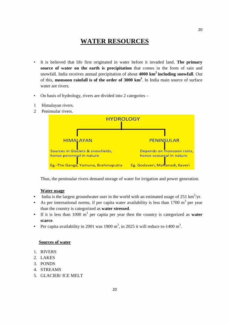
• It is believed that life first originated in water before it invaded land. The primary source of water on the earth is precipitation that comes in the form of rain and snowfall. India receives annual precipitation of about 4000 km3 including snowfall. Out of this, monsoon rainfall is of the order of 3000 km3. In India main source of surface water are rivers.
• On basis of hydrology, rivers are divided into 2 categories –
1 Himalayan rivers. 2 Peninsular rivers.
Thus, the peninsular rivers demand storage of water for irrigation and power generation. Water usage
• India is the largest groundwater user in the world with an estimated usage of 251 km3/yr. • As per international norms, if per capita water availability is less than 1700 m3 per year
than the country is categorized as water stressed. • If it is less than 1000 m3 per capita per year then the country is categorized as water
scarce. • Per capita availability in 2001 was 1900 m3, in 2025 it will reduce to-1400 m3.
Sources of water
1. RIVERS 2. LAKES 3. PONDS 4. STREAMS 5. GLACIER/ ICE MELT
21
21
6. OCEANS 7. SEAS (MARINE) 8. WELLS 9. RAINWATER
SURFACE WATER AND GROUND WATER
Surface water
• The rivers are the main sources of surface water in India apart from ponds, tanks and reservoirs.
• The Indus, the Ganga and the Brahmaputra carry 60% of the total surface water
Ground water
• Apart from the water available in the various rivers of the country, the ground water is also an important source of water for drinking, irrigation, industrial uses, etc.
• A) 80% for domestic water requirement
B) More than 45% for the total irrigation.
Over- utilization of surface and ground water
The water scarcity is an outcome of large and growing population and consequent greater demands for water. Demand of fresh water is increasing by 64 billion cubic meters every year.
Hence to facilitate higher food production, water resources are being over- exploited to expand irrigated areas and dry- season agriculture along with other developmental activities like production of hydroelectricity, water supply for industrial and domestic use, recreation, inland navigation and fish breeding.
Over-utilization of groundwater leads to decrease in water level thereby causing earthquake and floods. Over- utilization may even lead to drought.
Consequences of over exploitation of surface water
• To trap and control flowing of surface water, dams and reservoirs are build.
• The stored river water along with rainwater in a dam or a reservoir is used for irrigation, electricity generation, etc.
• These dams and reservoirs have enormous ecological impacts.
When a river is dammed, valuable fresh water habitats are lost.

22
22
1. Sometimes, river’s flow is diverted to cities or croplands, which affects the fishes and aquatic organisms.
2. The wildlife that depends on the water or the food chains involving aquatic organisms is also adversely affected.
3. Sometimes, fishes swim up river from the ocean to spawn are seriously affected by reduced water level.
4. The reservoirs which are created on the floodplains also submerge the existing vegetation and soil leading to its decomposition over a period of time.
5. Due to diversion in the river’s flow, estuaries are also affected because less fresh water enters and flushes the estuary.
6. Consequently, salt concentration increases profoundly affecting the estuary’s ecology. Consequences due to depletion of groundwater If the groundwater withdrawals exceed its recharge, the water table falls. It leads to fall in the springs and seeps start drying up. Thus, surface water diminishes and this creates the same results as the diversion of surface water.
In agriculture it leads to water logging. Water logging refers to the saturation of soil with water. Another problem resulting from dropping water tables is saltwater intrusion. In the coastal areas, the springs of overflowing groundwater may lie under the ocean. As long as a high water table is maintained a sufficient head of pressure is available in aquifer and freshwater will flow into the ocean. Thus, wells in the coastal areas have fresh water. Lowering of water table at rapid rate reduces pressure in the aquifer and thus permitting salt water to flow into the aquifer and hence into wells.

23
23
FLOODS Flood is a general or temporary condition of partial or complete inundation of normally dry land areas from overflowing of inland or tidal water or from rapid accumulation of surface water from any source.
� It can occur nearly ANYWHERE at any time. � It can result from excess water dams on rivers even moderate rain single heavy
downpour. � In India, the worst suffering states are Assam, Bihar, Orissa, U.P. and West Bengal.
Causes of Flood
1. Heavy Rains 2. Overflowing Rivers 3. Broken Dams 4. Urban Drainage Basins 5. Storm Surges and Tsunamis 6. Channels with Steep Sides 7. Lack of Vegetation 8. Melting Snow and Ice
Effects of Flood
• Agricultural lands are destroyed due to crops being submerged in water. Plains become silted with mud and sand, thus affecting the cultivable land areas and crops. This causes a lot of economic loss to farmers.
• Structural damage- They wreck buildings and houses, particularly kucchha houses in the villages. They cause disruption of all transport and communication.
24
24
• There is shortage of drinking water as hazardous chemicals end up in water and contaminate the water bodies.
• They harm human, animal and plant life. • Health effects- They cause a rise in epidemics because of water logging. Malaria and
diarrhea are common diseases during floods. They cause decay of organic matter, leading to growth of infection-spreading germs.
• They affect the ecosystem in a negative way. • They cause a lot of harm to the economy of the region.
Flood Management Floods cause tremendous destruction of life and property. But there are ways of protection against floods:
• If an area is prone to floods, houses in the region should be constructed on raised platforms.
• Rivers should be mapped and the surrounding areas appropriately prepared for floods. • Houses should be insured to protect against economic losses. • Placing sandbags around houses can save property. • Dams can be constructed to prevent against losses from floods. They control the water
flow. • Afforestation programs should be supported because depletion of forests is causing a rise
in the number of floods witnessed almost every year across the globe. • Rivers should be cleared of harmful garbage like plastics. • Floods should be well forecasted and warnings systems should be in place. • Flood Forecasting- A process of estimating and predicting the magnitude, timing and
duration of flooding based on known characteristics of a river basin. The first forecasting station was set up on Yamuna at Delhi Railway Bridge in 1958. DROUGHT A lack or shortage of water for an unusually long period of time, involving 50% less than the usual rainfall over 3 months A drought starts when total rainfall is well below average for several months. Other signs of drought include: Very dry soil, Trees have a sign of dying, Weather getting hotter and hotter
Types of Drought There are three types of drought: a) Meteorological drought
25
25
b) Hydrological drought c) Agricultural drought
Meteorological drought Meteorological drought is generally defined by comparing the rainfall in a particular place and at a particular time. This happens when the actual rainfall in an area is significantly less than the climatological mean of that area. Meteorological drought leads to soil moisture and this always has an effect on crops production.
Hydrological drought Hydrological drought is associated with the affect of low rainfalls on water level in reservoirs, rivers & lakes. This type of drought is noticed sometimes after a meteorology drought.
Agricultural drought Agricultural drought occurs when there isn’t enough water for a crop to grow at the particular time. This type of drought doesn’t depend only in the amount of rainfalls where water is used carelessly for irrigation and other purpose Sequence of impact: Meteorological -> Agricultural -> Hydrological Causes of drought
• Over-exploitation of surface and groundwater • Deficiency of rainfall • Deforestation
• Soil erosion • Global warming
• Ozone layer depletion
Impacts of drought Drought has a direct and indirect impact on the economic, social and environmental issues of the country
Visible impact is felt by agricultural sector Drop in surface water and ground water Food grain production goes down
The impact of drought can be reduced through mitigation and preparedness. Planning well in advance to mitigate drought would relieve the most suffering and at lesser expense.
26
26
CONFLICTS OVER WATER Water is essential for our existence and is fast becoming scarce. Rapidly increasing population and limited water resources give rise to conflicts over water. Causes of conflicts
Major causes of conflicts over water resources include: • Poor water allocation • Wasteful use • Lack of management action • Trans boundary pollution • Disputes in management of international and national river basins
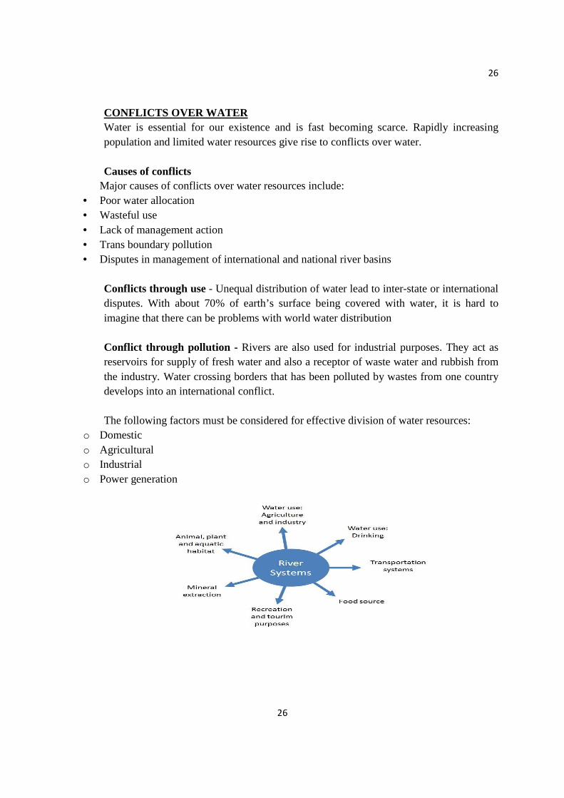
Conflicts through use - Unequal distribution of water lead to inter-state or international disputes. With about 70% of earth’s surface being covered with water, it is hard to imagine that there can be problems with world water distribution Conflict through pollution - Rivers are also used for industrial purposes. They act as reservoirs for supply of fresh water and also a receptor of waste water and rubbish from the industry. Water crossing borders that has been polluted by wastes from one country develops into an international conflict. The following factors must be considered for effective division of water resources:
o Domestic o Agricultural o Industrial o Power generation
27
27
MANAGEMENT OF WATER CONFLICTS
• Concerted efforts are required to enforce laws that check these practices to control water pollution
• In order to overcome the problem of sharing river water in a country, the concept of interlinking of rivers has been suggested
• Rivers should be nationalized; the National Water Authority and River Basin Authority should be given powers to ensure equitable distribution of basin water.
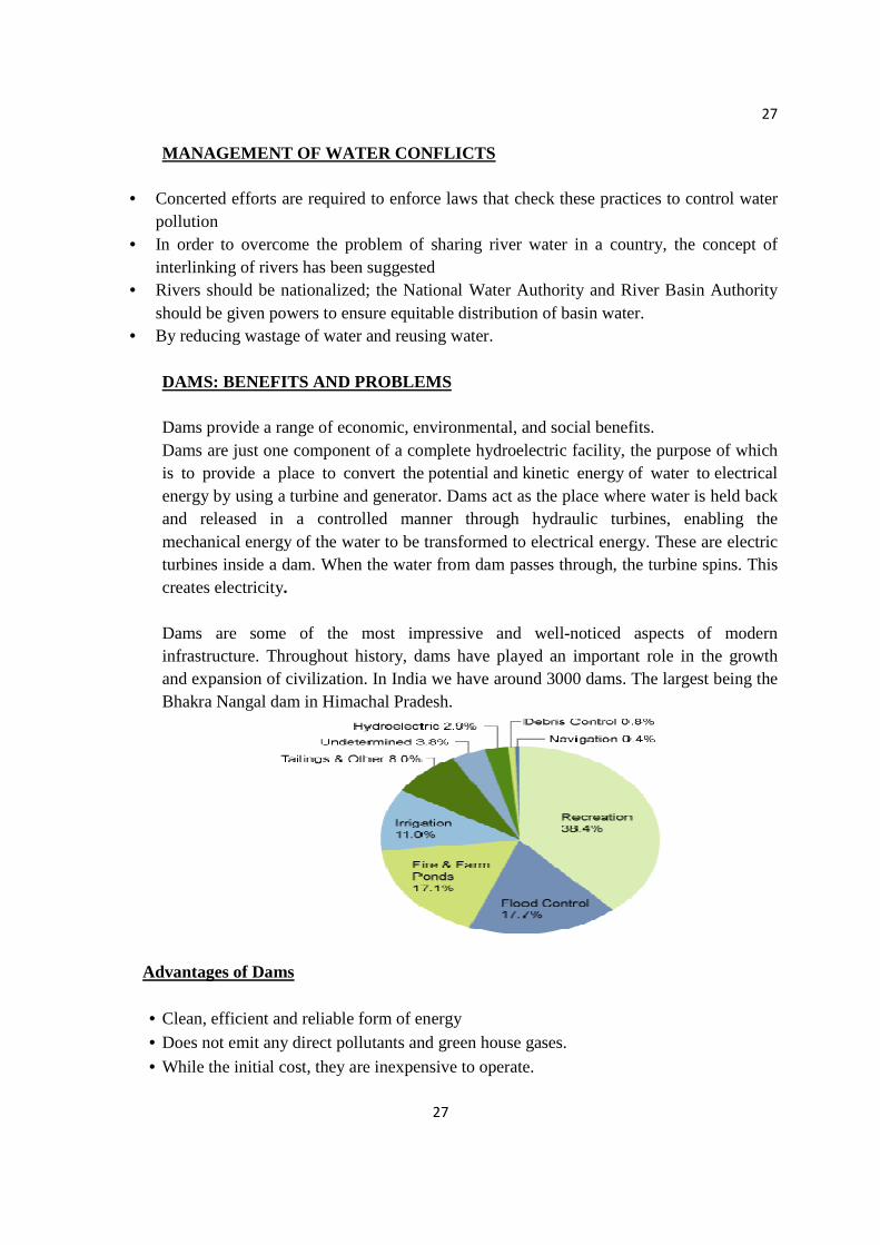
• By reducing wastage of water and reusing water. DAMS: BENEFITS AND PROBLEMS Dams provide a range of economic, environmental, and social benefits. Dams are just one component of a complete hydroelectric facility, the purpose of which is to provide a place to convert the potential and kinetic energy of water to electrical energy by using a turbine and generator. Dams act as the place where water is held back and released in a controlled manner through hydraulic turbines, enabling the mechanical energy of the water to be transformed to electrical energy. These are electric turbines inside a dam. When the water from dam passes through, the turbine spins. This creates electricity. Dams are some of the most impressive and well-noticed aspects of modern infrastructure. Throughout history, dams have played an important role in the growth and expansion of civilization. In India we have around 3000 dams. The largest being the Bhakra Nangal dam in Himachal Pradesh.
Advantages of Dams
• Clean, efficient and reliable form of energy • Does not emit any direct pollutants and green house gases.
• While the initial cost, they are inexpensive to operate.

28
28
• Electricity generated by hydroelectric power plant is the cheapest electricity generated.
• Can protect uncontrolled flooding
• Dams supply water for local drinking needs. • They allow for fish farming
• Dams store water for irrigation in summer seasons and dry months. Many desert areas can now farm due to dams and canals that supply water. Stabilize water flow / irrigation Dams are often used to control and stabilize water flow, often for agricultural purposes and irrigation. Plants will grow naturally on fertile soil that is watered by rain. However, in regions of the world where the climate is very dry for some seasons, the soil becomes so dry that it restricts the growth of vegetation. This problem can be overcome by irrigation, a man-made system for watering the land. Irrigation water can be stored in reservoirs during the rainy season, then in the drier seasons it can be released from the reservoir and distributed over the land through a system of canals. Usually, the water flows under the influence of gravity to the areas requiring it, or the water can be pumped out of the canals onto the land. Navigation Storage reservoirs are often designed to maintain a sufficient channel flow downstream to make the stream navigable. Required water volume, depending upon type and volume of traffic in a waterway, shows a marked seasonal variation. Recreation In general, publicly recreational benefits, such as boating, swimming and fishing, are only secondary uses. Large and rapid fluctuations in reservoirs’ water levels or fluctuations in downstream releases usually restrict recreational activities. DISADVANATGES: 1. Dams are extremely expensive to build and must be built to a very high standard. The high cost of dam construction means that they must operate for many decades to become profitable. 2. People living in villages and towns that are in the valley to be flooded, must move out. This means that they lose their farms and businesses. In some countries, people are forcibly removed so that hydro-power schemes can go ahead. 3. The building of large dams can cause serious geological and ecological damage.
29
29
4. The flooding of surrounding areas displaces existing wildlife and can disrupt whole ecosystems. Furthermore, marine life that relies on the unobstructed flow of the river, such as salmon and other migratory fish, can be adversely affected. 5. Erosion of surrounding soil also takes place. 6. Risk of Failure: Sometimes dams fail due to landslides or earthquake which can be catastrophic. 7. Reduces area for certain recreation like fishing, hunting, camping, etc
WATER CONSERVATION AND MANAGEMENT Water conservation is a practice in which people, companies, and governments attempt to reduce their water usage. Water is essential to life on earth. We need water to grow food, keep clean, provide power, control fire, and last but not least, we need it to stay alive! Several approaches to conserve and manage water resources are-
� Avoid Polluting- Pollution makes water unfit for use. Properly dispose of soil so it does not get into water. Use pesticides sparingly and do not use of soaps and detergents.
� Dispose off properly- Proper disposal of waste water helps in protecting natural water supplies.
� Install conservation practices- Many approaches can be use to conserve water. � Have good equipment- There should be good equipment as more water must be pumped
just to have enough to do what is needed. � Reuse- Water used for one purpose can often be use for other purposes before it is
released. � Efficient use of water- Everyone can make better use of water by consuming the little
less water for daily chores. � Roof top rain water harvesting-It is used to store drinking water in Rajasthan. � Bamboo drip irrigation - This is a old system of Meghalaya in which trapping stream
and spring water.
Simple Ways to Conserve Water
• When washing dishes by hand, don't let the water run while rinsing. Fill one sink with wash water and the other with rinse water.
• Run your clothes washer and dishwasher only when they are full. You can save up to 1,000 gallons a month.
• Some refrigerators, air conditioners and ice-makers are cooled with wasted flows of water. Consider upgrading with air-cooled appliances for significant water savings.
30
30
• Adjust sprinklers so only your lawn is watered and not the house, sidewalk, or street.
• Plant in the fall when conditions are cooler and rainfall is more plentiful.
• Use the garbage disposal sparingly. Compost vegetable food waste instead and save gallons every time.
• Water your lawn and garden in the morning or evening when temperatures are cooler to minimize evaporation.
• Wash your fruits and vegetables in a pan of water instead of running water from the tap.
RAIN WATER HARVESTING
Rainwater harvesting (RWH): technology used for collecting and storing rainwater for human use from rooftops, land surfaces or rock catchments.
Rainwater is an important water source in many areas with significant rainfall but lacking any kind of conventional, centralised supply system.
Rainwater is also a good option in areas where good quality fresh surface water or groundwater is lacking.
pH of normal rain is 5.6. Hence, slightly acidic in nature. It could be used as a supplement to piped water supply e.g. for toilet flushing, washing
and garden spraying RWH is a decentralised, environmentally sound solution, which can avoid many
environmental problems often caused in centralised conventional large-scale water supply projects. Types of Rainwater Harvesting Systems
1. Roof catchments • Simple roof water collection system for households • Larger systems for educational institutions, stadiums, airports, and other facilities • Roof water collection systems for high-rise buildings in urbanised areas
2. Ground catchments (man-made) 3. Rock catchments (natural, impervious outcrops) 4. Collection of storm water in urbanized catchments for recharge

31
31
Typical Domestic Rainwater Harvesting System
Rain water harvesting in urban areas
In view of increasing migration to urban area and the emergence of mega-cities in the next millennium, it is imperative that water supply systems should be evolved to cater for such a development.
Installation RWH system is mandatory for the construction of buildings in some towns in India and on the Virgin Islands, USA.
Many government agencies and municipalities worldwide provide grants/subsidies and technical know-how to promote RWH system.
Advantages of RWH
RWH systems provide water at or near the point where water is needed or used. Rainwater is relatively clean and the quality is usually acceptable for many purposes
with little or even no treatment. System is independent and therefore suitable for scattered settlements. Local materials and craftsmanship can be used in construction of rainwater system. Ease in maintenance by the owner/user. Provides a water supply buffer for use in times of emergency or breakdown of the public
water supply systems. Limitations of RWH
The initial cost (mainly of storage tank) may prevent a family from installing a RWH system.
The water availability is limited by the rainfall intensity and available roof area.
32
32
Mineral-free rainwater has a flat taste, which may not be liked by many. The poorer segment of the population may not have a roof suitable for rainwater
harvesting. Domestic RWH will always remain a supplement and not a complete replacement for
city-level piped supply or supply from more ‘reliable’ sources.
WATERSHED MANAGEMENT
What is a watershed? The area of land which drains or sheds water into a specific receiving water body like lake or a river. As rainwater or melted snow runs downhill in the watershed, it collects and transports sediment and other materials and deposits them into the receiving water body
Importance of watershed Watershed sustains life in more than one way. According to the Environmental Protection
Agency, more than $450 billion in foods, fibre, manufactured goods and tourism depends on clean, healthy watersheds. Healthy watersheds are also very important for the sustenance of human life. Water shed management
The process of implementing land use practices and water management practices to protect and improve the quality of water and other natural resources within a watershed by managing the use of those land and water resources in a comprehensive manner.
OBJECTIVES OF WATERSHED MANAGEMENT Protecting, conserving and improving the land resources for efficient and sustained
production Protecting and enhancing water resources, moderating floods, increasing irrigation and
conserving rainwater for crops APPROACH FOR WATERSHED MANAGEMENT AND DEVELOPMENT
People’s participation is the key to watershed development programme. While the main development activities have to be carried out by the watershed
community itself, the overall facilitation, coordination and supervision of the whole programme will be responsibility of a PROJECT IMPLEMENTATION AGENCY (PIA)
The whole setup for the watershed management follows a hierarchical approach Since everyone is a part of watershed:

33
33
Don’t pour toxic household chemicals down the drain; take them to a hazardous waste center
Recycle yard waste in a compost pile and practice mulching Adopt your watershed
Note: Any two Case studies for self-learning (to be done by the students)
Examples 1. Kaveri water dispute 2. Indus river treaty 3. A case study of water scarcity in Jabalpur
34
34
FOOD RESOURCES
• The food resources are a composite of the goods (the foodstuffs) and the services in commerce and distribution through which these are made available for consumption.
Major Sources of Food
• Croplands
• Rangelands
• Fisheries
World food problems
• The global food problem consists of the lack of food provision for the Earth’s population.
• The total number of people suffering from a lack of food is over one billion worldwide.
• Most of these people live in the rural areas of the poorest developing countries. (South Asia, Sub-Saharan Africa).
• An average human requires 2600 Kcal per day. People who receive fewer calories than this are undernourished.
• Currently around 800 million people are undernourished worldwide.
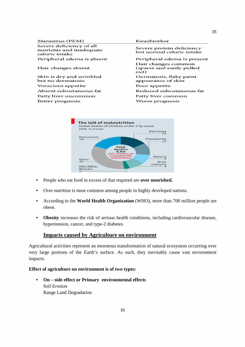
• Malnutrition is a condition that results from eating a diet in which one or more nutrients are either not enough or are too much such that the diet causes health problems.
• WHO estimates that malnutrition accounts for 54 percent of child mortality worldwide, about 1 million children.
The two most common diseases of malnutrition are:
35
35
• People who eat food in excess of that required are over nourished.
• Over nutrition is most common among people in highly developed nations.
• According to the World Health Organization (WHO), more than 700 million people are obese.
• Obesity increases the risk of serious health conditions, including cardiovascular disease, hypertension, cancer, and type-2 diabetes.
Impacts caused by Agriculture on environment
Agricultural activities represent an enormous transformation of natural ecosystem occurring over very large portions of the Earth’s surface. As such, they inevitably cause vast environment impacts.
Effect of agriculture on environment is of two types:
• On – side effect or Primary environmental effects Soil Erosion Range Land Degradation

36
36
• Off – side effect or Secondary environmental effects Water pollution Air pollution Dispersal of agricultural chemicals
Soil erosion is defined as the wearing away of topsoil. Topsoil is the top layer of soil and is the most fertile because it contains the most organic, nutrient-rich materials.
Soil erosion on agricultural lands takes place through three major processes:
• Overland flow erosion
• Wind erosion
• Streambank erosion
Surface runoff (also known as overland flow) is the flow of water that occurs when excess stormwater, meltwater, or other sources flows over the Earth's surface.
Overland Flow occurs when the soil becomes saturated, and any additional precipitation or irrigation causes runoff.
Wind erosion occurs when the wind takes fine particles of dirt and dust into the area and can move said particles over long distances.
Streambank erosion is limited to the border streams.
Erosion Prevention Techniques:
Plant, grass, shrubs and trees as plants bind the soil together and prevent soil erosion. Build retaining walls badly eroded slopes will continue to collapse downhill until they
are stabilized. Improve drainage all buildings should have gutters or pipes that can drain water
effectively without adequate drainage, heavy rain could wash away a whole layer of topsoil.
Turn a hillside into terraces the steepest slopes are almost impossible to farm on.
Rangeland degradation:
• Rangeland is a term used to describe arid or semi-arid land that is well suited for grazing. Vegetation found on rangeland often consists of native grasses, grass-like plants, shrubs
• It provides forage for limited numbers of domestic animals.
• As the number of animals on these lands increases the carrying capacity, overgrazing occurs which results in devegetation, erosion and ultimately desertification.
37
37
Overgrazing occurs when plants are exposed to intensive grazing for extended periods of time, or without sufficient recovery periods.
Causes of overgrazing:
• Man-made overgrazing usually happens when landowners become irresponsible. They don’t treat the land with the respect that it deserves.
• Poor control of grazing of animals.
• Drought or decline in precipitation
• Improper land use
• Overstocking
Effects of overgrazing:
• Loss of valuable species
• Food shortage/famine
• Soil erosion
DESERTIFICATION
• Desertification is basically a process in which fertile land gets converted to a desert mainly because of adverse human impact.
• It occurs in parts of semiarid regions of the world.
OFF-SITE IMPACTS
• Water pollution occurs because of agricultural run-off which affects the aquatic ecosystem and also the water quality.
• Air pollution occurs because of blowing dust from the agricultural fields. • And dispersed chemicals like fertilizers and pesticides do effect the environment.
TYPES OF AGRICULTURE
a) SUBSISTENCE AGRICULTURE
b) MODERN / INDUSTRIALISED AGRICULTURE

38
38
SUBSISTENCE AGRICULTURE
Subsistence agriculture occurs when farmers grow food crops to feed themselves and their families. In subsistence agriculture, farm output is targeted to survival and is mostly for local requirements with little or no surplus trade. The typical subsistence farm has a range of crops and animals needed by the family to feed and clothe themselves during the year. Planting decisions are made principally with an eye toward what the family will need during the coming year, and secondarily toward market prices. "Subsistence peasants are people who grow what they eat, build their own houses, and live without regularly making purchases in the marketplace."
TYPES OF SUBSISTENCE AGRICULTURE
a) SHIFTING AGRICULTURE b) NOMADIC HERDING c) INTENSIVE SUBSISTENCE FARMING
• SHIFTING CULTIVATION :
In this type of agriculture, a patch of forest land is cleared by a combination of felling and burning, and crops are grown. After 2-3 years the fertility of the soil begins to decline, the land is abandoned and the farmer moves to clear a fresh piece of land elsewhere in the forest as the process continues. While the land is left fallow the forest regrows in the cleared area and soil fertility and biomass is restored. After a decade or more, the farmer may return to the first piece of land.
• NOMADIC HERDING:
In this type of farming people migrate along with their animals from one place to another in search of fodder for their animals. Generally they rear cattle, sheep, goats, camels and/or yaks for milk, skin, meat and wool. This way of life is common in parts of central and western Asia, India, east and south-west Africa and northern Eurasia. They carry their belongings, such as tents, etc.., on the backs of donkeys, horses, and camels.
• INTENSIVE SUBSISTENCE FARMING:
In intensive subsistence agriculture, the farmer cultivates a small plot of land using simple tools and more labor. Climate, with large number of days with sunshine and fertile soils permits growing of more than one crop annually on the same plot. Farmers use their small land holdings to produce enough, for their local consumption, while remaining produce is used for exchange against other goods. It results in much more food being produced per acre compared to other subsistence patterns.
39
39
THE GREEN REVOLUTION
By the middle of 20th century, serious food shortages occurred in many developing countries including India. It was widely recognized that additional food supplies were needed to feed their growing population. The development and introduction during the 1960’s of high yielding varieties of wheat and rice gave the chance to provide the people with adequate supplies of food. But the yielding varieties required intensive cultivation methods, including the use of commercial inorganic fertilizers, pesticides and mechanized machinery. To realise their potential, these agricultural technologies were passed from highly developed nations to developing nations. Using modern cultivation methods and the high-yielding varieties of certain staple crops to produce more food per acre of cropland is known as the Green revolution.
MODERN AGRICULTURE
Modern agriculture is an evolving approach to agricultural innovations and farming practices that helps farmers increase efficiency and reduce the amount of natural resources—water, land, and energy—necessary to meet the world’s food, fuel, and fiber needs. Modern agriculture is driven by continuous improvements in digital tools and data, as well as collaborations among farmers and researchers across the public and private sectors.
Modern agriculture revolutions
New technologies allow much greater production with less human labour, but have high social and environmental costs.
• Tractors (internal combustion engines)
• Hybrid crops
• Chemical fertilizers / pesticides
• Genetically modified crops
Advantages
• More people over the world eat more and better because of modern agriculture.
• It enables farmers to utilize new innovations, research and scientific advancements to produce safe, sustainable and affordable food.
40
40
• Yields of crops such as rice and wheat increased rapidly, the price of food declined; the rate of increase in crop yields generally kept pace with population growth and the number of malnourished people was reduced slightly.
• New technology like pesticides and mechanical farm equipments make it possible to grow large amounts of food with relatively few human hands.
Effects of Modern Agriculture
As we know that modern agriculture improved our affordability of food, increases the food supply, ensured the food safety, increases the sustainability and also produces more biofuels. But with the same time, it also leads to environmental problems. The impacts of modern agriculture on Environment are discussed below:
SOIL EROSION
CONTAMINATION OF GROUND WATER
EUTROPHICATION
WATER-LOGGING AND SALINITY
EXCESSIVE USE OF PESTICIDES
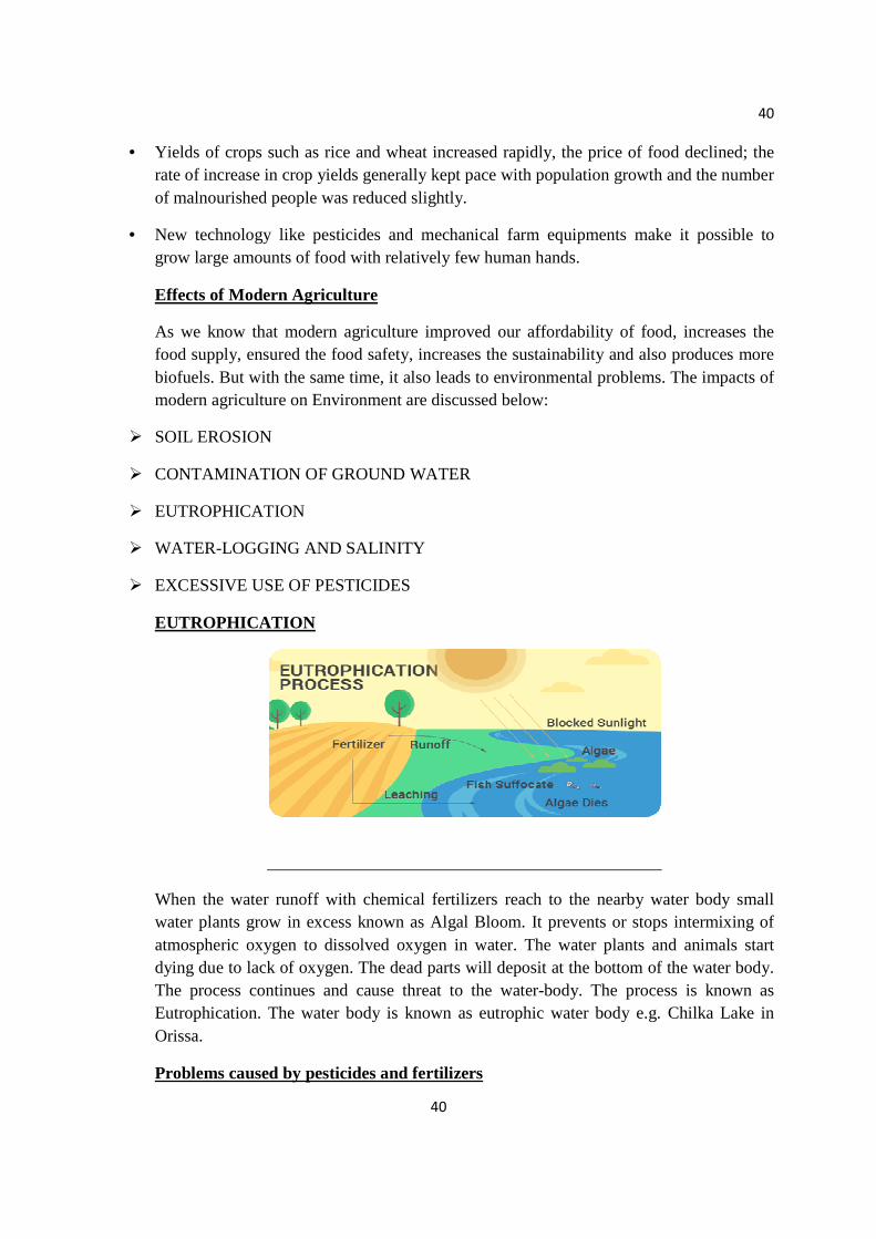
EUTROPHICATION
When the water runoff with chemical fertilizers reach to the nearby water body small water plants grow in excess known as Algal Bloom. It prevents or stops intermixing of atmospheric oxygen to dissolved oxygen in water. The water plants and animals start dying due to lack of oxygen. The dead parts will deposit at the bottom of the water body. The process continues and cause threat to the water-body. The process is known as Eutrophication. The water body is known as eutrophic water body e.g. Chilka Lake in Orissa.
Problems caused by pesticides and fertilizers

41
41
• Fertilizers are added to the soil to increase their fertility. The 3 major nutrients in fertilizers are fertilizers are Nitrogen, Phosphorus, and Potassium. Nitrogen is the most readily lost because of high solubility in the nitrate form. Leaching of Nitrate from agricultural fields can elevate concentrations in underlying groundwater to levels unacceptable for drinking water quality. Other elements don’t cause as such water quality problems, because they’re not hazardous in drinking water and is not a limiting nutrient for a growth of aquatic plants.
Pesticides and the problem caused by them
• The trend towards intensive crop production in modern farming has led to increased potential damage by pests and diseases. Hence, farmers have become dependent on the use of chemical compounds i.e., pesticides to prevent their crops from being destroyed. Pesticides generally kill not only the pest of concern, but also a wide range of other organisms, including beneficial insects and other pest predators. Once the effect of the pesticides wears off, the pest species is likely to recover more rapidly than it’s predators because of the differences in the available food supply. Hence, previously unimportant species may also become significant crop pests when their natural predators are killed by pesticide applications. With consistent use of pesticides, the species of the pest slowly become tolerant to the pests used hence leading to a gradual increase in the population of pests.
WATERLOGGING
Waterlogging is the natural flooding and over-irrigation of the soil that brings water at underground levels to the surface. As a consequence, displacement of the air occurs in the soil with corresponding changes in soil processes and an accumulation of toxic substances that impede plant growth.
Causes:
• It occurs when the soil-surface area becomes saturated and soil pores become full with water.
• It could occur due to:
Periods of heavy rain.
Poor irrigation Management.
Poor drainage.
Rising Water Table.
42
42
Impacts of Waterlogging:
1. Water-logged soil pores have no oxygen. Thus, creation of anaerobic condition in the crop root zone.
2. Vegetation can turn yellow, growth is stunted and thin. Trees and plants can die, and bare patches of soil appear.
3. Plants species more tolerant of saturated conditions will take over (eg. Sedges, pinrushes, dock). The growth of these wild plants totally prevents the growth of useful crops.
4. Accumulation of harmful salts in the plants.
5. Impossibility of tilling operations in the soil.
Remedial measures to curb water logging:
• Nitrogen: Apply nitrogen after a period of waterlogging. It will make nitrate readily available and accelerate plant recovery.
• Weeds: Keep the field free of weeds to reduce competition for oxygen in the root zone.
• Cultivation : Consider a light cultivation if crusting occurs after intense rainfall. This will help aerate the saturated soil.
• Raised beds: If the soil is prone to waterlogging, consider adopting the raised bed system with its intrinsically good drainage.
• Leveling: Level the field to improve the drainage channels and put them closer together.
• Irrigation schedule: Adjust the irrigation timetable to allow for rainfall events.
• Deep cultivation: Use deep cultivation to increase soil pore space and break up any hard pans that might have developed. Pore space should be around 10% to avoid waterlogging.
• Green manure: Next season, grow and then incorporate a green manure crop to improve soil organic matter and pore space. Alternatively incorporate farmyard manure or crop residues
• Management of drainage lines for efficient water flow.
• Management of surface water flow to avoid surface ponding
• Increase deep rooting vegetation for greater utilization of water from the soil.
In India, waterlogging is prevalent in the coastal regions of Mumbai and Kerala, estuarine deltas of Ganges, and Andaman and Nicobar islands. Canal Irrigation in Haryana resulted in rising water table followed by waterlogging and salinity. This in turn led to low crop
43
43
productivity and caused huge economic loss. Similarly, the Indira Gandhi Canal Project in Rajasthan converted a big area of land into a water soaked wasteland, leading to huge losses again.
SALINITY
• Soil salinity is a term used to describe the salt content within soil. Salt is a naturally occurring mineral within soil and water that affects the growth and vitality of plants.
• There are 2 main types of salinity:
1. Primary—naturally occurring salinity
2. Secondary—resulting from human activities.
• Primary salinity occurs naturally in soils and waters. Examples of naturally occurring saline areas include salt lakes, salt pans, salt marshes and salt flats.
• Secondary salinity is salting that results from human activities, usually land development and agriculture
Causes:
When irrigation is not accompanied by proper drainage, waterlogging occurs. This in turn brings salt to the surface, where it collects at the roots of plants or as a thin crust on the land surface.
Over a long period of time, soil minerals release salts. These salts also contributes to salinity.
It could occur due to:
Low Rainfall.
High Rainfall/Over-irrigation.
Poor Drainage.
High Temperatures.
Problems related to Salinity are mainly seen in drylands, arid area and irrigated rural areas where the concentration of soluble salts in the soil increases. Most of the African, Asian and American countries are affected by salinity. Around two-thirds of all irrigated land in Pakistan and 20% of land in India is salinized.
Impacts of salinity:

44
44
• Salinity is closely linked to soil erosion. Salinity is often associated with prolonged wetness and lack of surface cover and therefore increases the vulnerability of soils to erosion.
• If the level of salts in the soil water is too high, water may flow from the plant roots back into the soil due to osmosis. This results in dehydration of the plant, causing yield decline or even death of the plant.
• If the salt content of the soil is high, it will result in decline of plant and microbial population, and hence the nitrogen cycle will be affected.
• The water which flows through the salinized land to the river contains dissolved salts which results in salinization of fresh water rivers. This affects the quality of water for drinking and irrigation—with serious economic, social and environmental consequences for both rural and urban communities.
• High levels of salts may affect the taste of drinking water. Chloride in particular has a low taste threshold. Sodium and magnesium sulfate levels in drinking water may produce a laxative effect and reduce the suitability of a water supply for grazing animals. Methods of Prevention:
• Improving the soil drainage system. • Reclamation of salinized land by leaching with plenty of water.
• Avoid building dams at sites where the water table is high. • Monitor groundwater levels and the amount of salt in the land and water.
• Adopt cropping practices that minimise deep drainage. Managing salinity involves striking a balance between the volume of water entering and leaving the groundwater system.
Water Table can be lowered by: Planting, regenerating and maintaining native vegetation and good ground cover
in recharge, transmission and discharge zones, where possible Using more groundwater in recharge areas by pumping water from bores and
redirecting it to other storages Installing bores and interceptor drains in discharge areas—water of suitable
quality can be used to irrigate adjacent areas maximising cropping opportunities and minimising fallow land.
VARIOUS CONCERNS DUE TO MODERN AGRICULTURE a) Ecological concerns
• Loss of soil productivity • Pollution of soil resources
45
45
• Pollution and depletion of water resources
• Loss of crops and wild plant diversity
b) Economical impact c) Socio-cultural and heath impacts
SOIL CONTAMINATION
• Usage of High Yielding Variety Seeds (HYV-S) allowed for decreased time to maturity,
and hence increased cropping intensity. • But usage of chemicals greatly deteriorated the quality, hence making the land barren in
the long run and leading to problems such as: Micronutrient imbalance : Chemical fertilizers used in modern agriculture contain Nitrogen, Phosphorus and Potassium (N,P,K) which are macronutrients. Excess use of fertilizers in fields causes micronutrient imbalance. Particularly in Punjab, it caused deficiency of micronutrient Zinc thereby affecting productivity of soil. WATER CONTAMINATION
• Nitrate pollution : Excess Nitrogenous fertilizers applied in fields leach deep into the soil
contaminating the groundwater. If the concentration of nitrate in drinking water exceeds 25 mg/L it leads to a fatal condition in new-born babies. This condition is termed "Blue Baby Syndrome"
• Soil erosion, agricultural runoffs and dumping of waste into the water bodies has increased the concentration of heavy metals in the water bodies.
Note: Any two Case studies for self-learning (to be done by the students)
Examples 1. African famine 2. DDT and ‘Silent spring’: 50 years after 3. Effects of Modern Agriculture on Punjab (Fardikot) - A case study

46
46
MINERAL RESOURCES
• Minerals are naturally occurring, inorganic, solids, crystalline substances which contain a specific composition of elements.
• A mineral which can be extracted and processed at a profit is known as ore.
• Minerals are valuable natural resources being finite and non-renewable. They constitute the vital raw materials for many basic industries and are a major resource for development. A Mineral Resource is the concentration of minerals that are of economic interest in or on the crust of Earth. Almost all the minerals found on Earth are used for economic benefit. The Social and Economic development of a nation depends on its capacity to utilize these mineral resources without its wasteful use to the extent possible.
Types of mineral resources
METALLIC MINERALS
• Minerals are naturally occurring substances that are solid and amorphous. They are described by different physical properties such as crystal structure, luster, hardness, color, fracture and more. Metallic minerals are minerals that contain metallic elements.
• Metallic minerals contain metal elements in their chemical formula. The metal ores itself can be considered as a mineral.
• Some common metal minerals include Iron, Copper, Gold, Silver, etc.
47
47
Metallic minerals are of two types:
a) Ferrous minerals b) Non-ferrous minerals
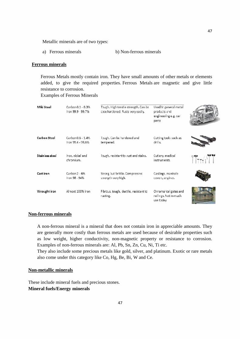
Ferrous minerals
Ferrous Metals mostly contain iron. They have small amounts of other metals or elements added, to give the required properties. Ferrous Metals are magnetic and give little resistance to corrosion. Examples of Ferrous Minerals
Non-ferrous minerals
A non-ferrous mineral is a mineral that does not contain iron in appreciable amounts. They are generally more costly than ferrous metals are used because of desirable properties such as low weight, higher conductivity, non-magnetic property or resistance to corrosion. Examples of non-ferrous minerals are: Al, Pb, Sn, Zn, Cu, Ni, Ti etc. They also include some precious metals like gold, silver, and platinum. Exotic or rare metals also come under this category like Co, Hg, Be, Bi, W and Ce.
Non-metallic minerals These include mineral fuels and precious stones. Mineral fuels/Energy minerals
48
48
• Fossil fuel also includes hydrocarbon-containing natural resources that are not derived entirely from biological sources, such as tar sands. These latter sources are properly known as mineral fuels. Fossil fuels contain high percentages of carbon and include coal, petroleum, and natural gas.
Precious stones A highly attractive and valuable piece of mineral, used especially in jewellery; a gemstone. In modern use the precious stones are diamond, ruby, sapphire and emerald, with all other gemstones being semi-precious. Crystals form from chemical elements present in the liquid rock, somewhat like the way rain turns into snow crystals in the cold.
Difference between metallic and non-metallic minerals
Metallic Non-metallic
Minerals that contain metals in their own Do not contain any metal in their compounds formula They are lustrous They don’t have shine of their own They are associated with igneous rocks They are associated with sedimentary rocks They are quite ductile They are non-ductile and can be broken upon collision They can be extracted by melting They do not yield new products on melting Importance of minerals
• Almost all rocks are made of minerals. • They have high aesthetic value, e.g. gemstones.
• They have natural resources value: Minerals are sources of metals needed for electronic manufacture, airplanes, cars, etc.
• Minerals are raw materials for making window glass, plaster, etc.
Mineral resources of India
49
49
• India's major mineral resources include Coal (4th largest reserves in the world), Iron ore, Manganese ore (7th largest reserve in the world as in 2013), Mica, Bauxite (5th largest reserve in the world as in 2013), Chromite, Natural gas, Diamonds, Limestone and Thorium.
• Major minerals found in the country are given below: 1. Bauxite ore(Aluminum) 2. Copper 3. Lead 4. Zinc 5. Manganese 6. Diamond
• COPPER
Copper is mainly found in Rajasthan, Madhya Pradesh, Jharkhand, Karnataka and Andhra Pradesh.
• MAGANESE Manganese deposits are found in Maharashtra, Madhya Pradesh, Chhattisgarh, Orissa, Karnataka and Andhra Pradesh.
• LIMESTONE States where limestone is found are Bihar, Jharkhand, Orissa, Madhya Pradesh, Chhattisgarh, Rajasthan, Gujarat and Tamil Nadu.
• IRON India has deposits of high grade iron ore. States where iron ore is found: Jharkhand, Orissa, Chhattisgarh, Madhya Pradesh, Goa, Maharashtra and Karnataka.
• BAUXITE Bauxite is found in many states. States where bauxite is found: Jharkhand, Orissa, Chhattisgarh, Madhya Pradesh, Gujarat, Maharashtra and Tamil Nadu.
• MICA India is the largest producer and exporter of mica in the world. States where mica is found: Jharkhand, Bihar, Andhra Pradesh and Rajasthan.
• GOLD Kolar in Karnataka has deposits of gold in India. These mines are among the deepest in the world.
Uses of minerals
The main uses of minerals are as follows:- • Development of Industrial plants and machinery. • Generation of energy e.g. coal, lignite, uranium.
50
50
• Construction , housing , settlements • Defense equipments weapons, armaments. • Medicinal system – particularly in Ayurvedic system. • Formation of alloys for various purposes (e.g. phosphorite). • Agriculture – as fertilizers, seed dressings and fungicides (e.g. zineb containing zinc,
Maneb-containing manganese etc.). • Jewellery (e.g. Gold, Silver, Diamond, Platinum, etc.).
Exploitation of Mineral Resources: Why are resources under pressure ? • Increase in the sophistication of technology enabling natural resources to be extracted
quickly and efficiently. • The human population is increasing. According to the UN, there were 7.6 billion of us in
2017. This number is expected to rise to about 10 billion in 2050 and about 11 billion in 2100.
• Materialistic views lead to the mining of gold and diamonds to produce jewelry, unnecessary commodities for human life or advancement. Consumerism also leads to extraction of resources for the production of commodities necessary for human life but in amounts excessive of what is needed.
• Excessive demand often leads to conflicts due to intense competition. • Non-equitable distribution of resources.
(a) Mining is hazardous occupation:
1. This occupation involves several health risk dust produced during mining operation are injurious to health and cause lung diseases.
2. Extraction of some toxic or radioactive minerals leads to life threatening hazards. 3. Dynamite explosion during mining is very risky as fumes produced are extremely
poisonous. 4. Underground mining is more hazardous than surface mining as there are more chances if
accidents like roof falls, flooding and inadequate ventilation etc. (b) Rapid depletion of high grade minerals: Increasing demand for high grade minerals has compelled miners to carry out more extraction of minerals, which require more energy sources and produce large amount of waste materials. (c) Wastage of upper soil layer and vegetation: Surface mining results in the complete destruction of upper soil layer and vegetation. After extraction, the wastes are dumped in an area which destroys the total surface and vegetation. (d) Environmental problems:
51
51
Over exploitation of mineral resources resulted in many environmental problems like: 1. Conversion of productive land into mining and industrial areas. 2. Mining and extraction process are one of the sources of air, water and land pollution. Overuse of energy sources results in emission of CO2, SO2, particulate matter which causes air pollution and related problems like, acid rains, global warming. 3. Mining involves huge consumption of energy resources like coal, petroleum, natural gas etc. which are in-turn non renewable sources of energy. 4. Surface mining directly degrades the fertile soil surface thus effect ecology and climate if that particular area. (e) Economic effects: As these resources get depleted, cost will increase, which will seriously effect economy and the development of the nation PROCESSING OF MINERALS
Extraction of Minerals
• Mining is the extraction of valuable minerals or other geological materials from the earth, usually from an orebody, lode, vein, seam, reef or placer deposit. These deposits form a mineralized package that is of economic interest to the miner.
• Mineral processing, art of treating crude ores and mineral products in order to separate the valuable minerals from the waste rock, or gangue. It is the first process that most ores undergo after mining in order to provide a more concentrated material for the procedures of extractive metallurgy.

52
52
Mining can be carried out in two ways: a) Surface mining b) Sub-surface or underground mining
• Surface mining is done by removing (stripping) surface vegetation, dirt, and, if
necessary, layers of bedrock in order to reach buried ore deposits. • Techniques of surface mining include:
Open-pit Mining, which is the recovery of materials from an open pit in the ground.
Quarrying, identical to open-pit mining except that it refers to sand, stone and clay.
Strip Mining, which consists of stripping surface layers off to reveal ore/seams underneath.
Mountaintop Removal, commonly associated with coal mining, which involves taking the top of a mountain off to reach ore deposits at depth.
• Sub-surface mining consists of digging tunnels or shafts into the earth to reach buried ore deposits. Ore, for processing, and waste rock, for disposal, are brought to the surface through the tunnels and shafts.
• It can be classified by the type of access shafts used, the extraction method or the technique used to reach the mineral deposit.
• Drift mining utilizes horizontal access tunnels, slope mining uses diagonally sloping access shafts, and shaft mining utilizes vertical access shafts.
IMPACT OF MINING ON MINERS
• They run the risk of serious physical injuries while handling heavy equipment or moving materials around.
• Dust from the mine site is dangerous for their respiratory systems. This danger is greatest in coal mines.
• If miners are working in deep mines, there is always the danger of getting trapped there due to collapse of a tunnel. No matter how low the chances, this thought will play in their minds when they go into work. It adds mental stress.
• Miners generally live around the mine site with their families. The mine spoils dumped can affect their quality of life, with water related diseases being the greatest risk.
ENVIRONMENTAL EFFECTS OF EXTRACTING AND USING MINER AL RESOURCES
53
53
1. Pollution 2. Land degradation 3. Subsidence 4. Noise 5. Energy 6. Impact on the Biological Environment 7. Long-term Supplies of Mineral Resources
POLLUTION
• Mining operations often pollute the atmosphere, surface waters and ground water. • Rainwater seeping through spoil heaps may become heavily contaminated, acidic or
turbid, with potentially devastating effects on nearby streams and rivers. • Trace elements (cadmium, cobalt, copper and others) when leached from mining wastes
and concentrated in water, soil or plants, may be toxic or may cause diseases in people and other animals who consume contaminated water or plants, or who use the soil.
• Specially constructed ponds to collect runoff can help but cannot eliminate all problems. • Huge volumes of dust generated by explosions, transportation and processing may lead to
the death of surrounding vegetation. Chemicals used in the extraction processes, such as drilling muds, are often highly polluting substances. LAND DEGRADATION
• Mining activity can cause a considerable loss of land because of chemical contamination, destruction of productive layers of soil, and often permanent scarring of the land surface.
• Large mining operations disturb the land by directly removing material in some areas and by dumping waste in others.
• There can be a considerable loss of wildlife habitat. SUBSIDENCE
• The presence of old, deep mines may cause the ground surface to subside in a vertical or horizontal direction.
• This may severely damage buildings, roads and farmland, as well as alter the surface drainage patterns. NOISE POLLUTION
• Blasting and transport cause noise disturbance to local residents and to wildlife. • It increases noise pollution which is harmful for humans as well as animals. • Many blasting activities also lead to damages to minerals while extracting them.
ENERGY
• Extraction and transportation requires huge amounts of energy which adds to impacts such as global warming.
54
54
• More Energy consumption leads to increase in power input which in turn leads to increase in cost of extraction of minerals.
• Energy requirement of some of minerals of very high and undergo a series of processes. IMPACT ON THE BIOLOGICAL ENVIRONMENT
• Physical changes in the land, soil, water and air associated with mining directly and indirectly affect the biological environment.
• Direct impacts include death of plants or animals caused by mining activity or contact with toxic soil or water from mines.
• Indirect impacts include changes in nutrient cycling, total biomass, species diversity, and ecosystem stability due to alterations in groundwater or surface water availability or quality. LONG TERM SUPPLIES OF MINERAL RESOURCES
• The economies of industrialized countries require the extraction and processing of large amounts of minerals to make products. As other economies industrialize, their mineral demands increase rapidly. The mineral demands of countries in Asia, such as Malaysia, Thailand and South Korea have grown phenomenally in the last twenty years.
• Since mineral resources are a non-renewable resource, it is important for all countries to take a low-waste sustainable earth approach to dealing with them. Developed countries need to change from a high-waste throw away approach and developing countries need to insure that they do not adopt such an approach. Low-waste approach requires emphasis on recycling, reusing and waste reduction and less emphasis on dumping, burying and burning. CONSERVATION OF MINERAL RESOURCES
• The mineral resources are very essential for the growth and the development of a country. The ever increasing population in the world with improved lifestyles is responsible for the rapid consumption of mineral resources. The geological processes of mineral formation are so low that the rates of replenishment are very small in comparison to the present rates of consumption. Thus, mineral resources are valuable but they will be available for a limited time. A sincere effort has to be made in order to use the mineral resources in a planned and sustainable manner. Steps to be followed:
1. Encourage use of improved technology so as to reduce waste generation. 2. Encourage recycling of metals. 3. Regulate the use of mineral resources. 4. Reduce the purchase of unwanted product made from mineral resources.
55
55
5. Encourage research for providing suitable eco- friendly alternative for fossil fuel, metal, etc. These are known as 4R’s for the sustainable use of mineral resources. REMEDIAL MEASURES
• The low grade ores can be better utilized by using microbial-leaching technique. • This biological method is helpful from economic as well as environmental point of view. • Restoration of mined areas by re-vegetating them. • Develop a suitable compensatory forest. • Cut the trees to the minimum possible extent and to preserve the flora it would be
appropriate to uproot the trees and plants.
Note: Any two Case studies for self-learning (to be done by the students) Examples: 1. No Mining in Aravalis 2. Environmental Impact of Mining Activity on Land Use : A Case Study of Udaipur
Mineral Basin
56
56
LAND RESOURCES
LAND AS A RESOURCE
• Land – It is part of the Earth’s surface that is not covered by water
• Land resources - The resources which are derived from land, in order to satisfy our needs are known as ‘LAND RESOURCES’.
It is the most important natural resource.
It forms about 1/5th of the earth’s surface.
It supports natural vegetation, wildlife, human life, economic activities, transport and communication system.
Examples : Forests, etc.
Land is a natural resource of utmost importance. We live on land, it supports natural vegetation and wild life. We perform our economic activities on land and use it in different ways to fulfil our need. Land resources includes natural resources for an example - gold , timber , coal , iron ore , uranium, oil, water , soil , air , plants, and animals. Land is used for a variety of purposes say for agriculture, setting up of industries, building houses, airports, shopping, malls, mining, forestry, construction of roads, railway offices, etc. It holds everything that constitutes terrestrial ecosystems.
Need of studying land resources
• Land is available in finite amount and human life is entirely supported by land.
• The increasing population has put a great pressure on land resources as a result it is important to use them with proper planning.
• Unequal utilization of land damages the livelihood of living organisms.
Geographical areas of the India’s mainland
1. Northern Mountains (Himalayas)
2. The Great Plains (Indo -Gangetic Plains)
3. The Deccan Peninsula (South India)
4. Coastal Plains and Islands (The Ghats and Islands)
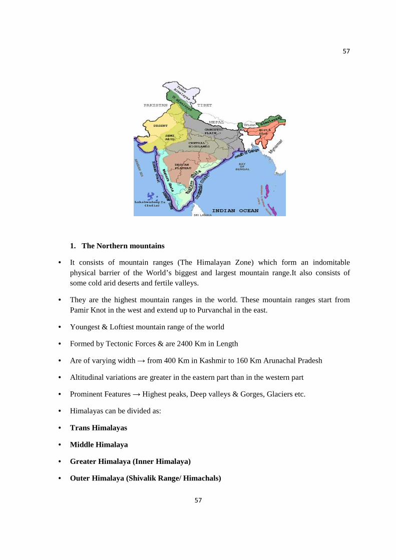
57
57
1. The Northern mountains
• It consists of mountain ranges (The Himalayan Zone) which form an indomitable physical barrier of the World’s biggest and largest mountain range.It also consists of some cold arid deserts and fertile valleys.
• They are the highest mountain ranges in the world. These mountain ranges start from Pamir Knot in the west and extend up to Purvanchal in the east.
• Youngest & Loftiest mountain range of the world
• Formed by Tectonic Forces & are 2400 Km in Length
• Are of varying width → from 400 Km in Kashmir to 160 Km Arunachal Pradesh
• Altitudinal variations are greater in the eastern part than in the western part
• Prominent Features → Highest peaks, Deep valleys & Gorges, Glaciers etc.
• Himalayas can be divided as:
• Trans Himalayas
• Middle Himalaya
• Greater Himalaya (Inner Himalaya)
• Outer Himalaya (Shivalik Range/ Himachals)

58
58
• Location :
Jammu & Kashmir, Himachal Pradesh, North-West Uttar Pradesh, Sikkim, part of Assam and the North-Eastern states of Arunachal Pradesh, Nagaland, Manipur, Mizoram, Tripura and Meghalaya.
2. The Great Plains Indo-Gangetic Plain, also called North Indian Plain , extensive north-central section of the Indian subcontinent, stretching westward from (and including) the combined delta of the Brahmaputra valley and the Ganges (Ganga) River to the Indus River valley. The region contains the subcontinent’s richest and most densely populated areas. The greater part of the plain is made up of alluvial soil, deposited by the three main rivers and their tributaries. The eastern part of the plain has light rains or drought in the winter, but in summer rainfall is so heavy that vast areas become swamps or shallow lakes. The plain becomes progressively drier toward the west where it incorporates the Thar (Great Indian) Desert. Location :
a. It extends from Rajasthan in the west to Brahmaputra valley in the east. b. It covers entire states of Punjab, Haryana and the Union Territory of
Chandigarh and Delhi and major parts of Uttar Pradesh, Bihar, West Bengal and parts of Assam.
3. The Deccan Peninsula • The name derives from the Sanskrit Daksina (“south”).
• The plateau is bounded on the east and west by the Ghats, escarpments that meet at the plateau's southern tip.
• The Indo Gangetic Plains an the Peninsula Plateau are separated by mountain and hill ranges known as the Aravali, Vindhya, Satpura, Ajanta and Maikala Ranges.
Location : a. This includes the states of Tamil Nadu, Karnataka, Andhra Pradesh and
Kerala in the South India. b. This zone also includes State of Madhya Pradesh and parts of Odisha, Bihar
and West Bengal.
4. Coastal plains and Islands The coastline of India is divided into the Western Coastal Plains and the Eastern Coastal Plains. This is a region of very high density population This region consists of:

59
59
a. The Western coastal plain (lies between the Western Ghats and the Arabian sea).
b. The Eastern coastal plain (lies between the Eastern Ghats and the Bay of Bengal). Islands : Lakshadweep, The Andaman and Nicobar Islands.
LAND UTILIZATION
Land use involves the management and modification of natural environment or wilderness into built environment such as settlements and semi-natural habitats such as arable fields, pastures, and managed woods.
Purposes
1. Forests 2. Area under non-agricultural use 3. Barren and uncultivable land 4. Unsuitable for agriculture due to inaccessibility or because of topography. 5. Grazing lands 6. Fallow lands 7. Cropped areas
LAND DEGRADATION
Definition : Land degradation (or soil degradation) is a process in which the value of the biophysical environment is affected by a combination of human-induced processes acting upon the land. It is viewed as any change or disturbance to the land, perceived to be undesirable.
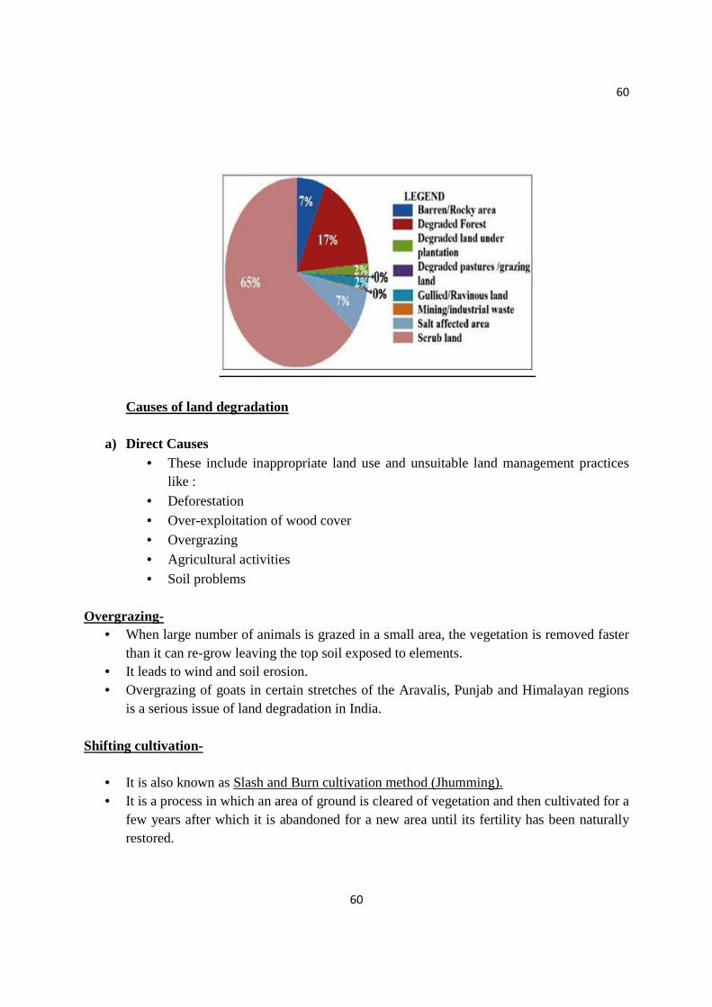
60
60
Causes of land degradation
a) Direct Causes • These include inappropriate land use and unsuitable land management practices
like :
• Deforestation
• Over-exploitation of wood cover • Overgrazing
• Agricultural activities
• Soil problems
Overgrazing- • When large number of animals is grazed in a small area, the vegetation is removed faster
than it can re-grow leaving the top soil exposed to elements. • It leads to wind and soil erosion. • Overgrazing of goats in certain stretches of the Aravalis, Punjab and Himalayan regions
is a serious issue of land degradation in India. Shifting cultivation-
• It is also known as Slash and Burn cultivation method (Jhumming). • It is a process in which an area of ground is cleared of vegetation and then cultivated for a
few years after which it is abandoned for a new area until its fertility has been naturally restored.
61
61
• It is ecologically destructive and uneconomic cultivation method which leads to soil erosion.
• In India, it is practiced in hill areas of North-East, Chhotanagpur, Odisha, Madhya Pradesh and Andhra Pradesh.
b) Indirect/Underlying Causes
These include the reasons due to which these inappropriate practices took place. • Land Shortage: It has always been recognized that land is a finite resource, but only
recently has the full impact of this fact occurred. In earlier times, food shortage or poverty could be combated by taking new, unused, land into cultivation.
• Poverty: Poverty leads to land degradation. It could almost certainly be shown that richer farmers maintain their soils in better state than poorer.
• Population factors like population pressure are the major cause of land degradation.
Continuous population growth results into land shortage since land is available in finite amount only. Hence, due to high population density the land degrades. Population pressure leads to inappropriate practices like irrigating unsuitable soils to obtain multiple crops for survival of the population. Inappropriate agricultural practices to meet the food requirements of population lead to soil degradation which in turn leads to land degradation.
SOIL PROBLEMS
• Soil erosion • Loss of fertility by mismanagement • Water logging • Salinity • Acidity • Soil structure deterioration • Desertification
Soil is a mixture of inorganic and organic materials on Earth that provides medium for plant growth. Soil is formed by Weathering of rocks. SOIL EROSION
• It is also known as Creeping death of land. • It is a process by which top soil is detached from land and either washed away by water,
ice or sea waves or blown away by wind. The process of soil formation and erosion go on simultaneously and generally there is a balance between the two which is disturbed by human activities like:
• Deforestation
62
62
• Faulty cultivation methods: Land is often left open for cultivation of tuber crops like potato and ginger without undertaking anti erosion methods like –Tracing of slopes. Also forests on slopes have been cleared at places to make way for plantation crops.
• Shifting Cultivation : A form of agriculture, in which an area of ground is cleared of vegetation and cultivated for a few years and then abandoned for a new area until its fertility has been naturally restored.
• Overgrazing: Excessive grazing which causes damage to grassland. • Diversion in natural drainage channels by Railway Embankments and Roads. • Lack of proper surface Drainage. • Denuding Forest Fires.
LOSS OF FERTILITY BY MISMANAGEMENT
1. Unscientific Cropping practice like growing crops on slopes, over-irrigation and use of fertilizers in order to satisfy needs of rapidly growing population.
2. Imbalancing of Nutrients by sudden rise in use of fertilizers. 3. Loss of Organic matter by usage of chemicals in soil which support fungal and microbial
soil population. 4. Soil pollution originates from development of industries, use of pesticides, chemical
fertilizers, etc. WATER LOGGING
• It is defined as a state whereby soil becomes saturated with water within the depth of the root zone for a period that affects yield and quality of crops.
• Cause : It happens when water table gets saturated due to: Over-irrigation, seepage from canals, inadequate drainage, Floods, etc.
• The land under water logged conditions can be used neither for agriculture nor for human settlements.
• In dry areas, water logging leads to salinity. ALKANILITY/SALINITY
• Occurs in areas of temporary water surplus and high temperatures • It is a process through which a layer of salt gets deposited on top soil which renders vast
stretches of useful land infertile. • Due to over irrigation or high rainfall, the moisture percolates down and dissolves the
underground salts in it. During the dry period, the solution comes to the surface by capillary action. The water gets evaporated, leaving behind a crust of salt of sodium, magnesium and Calcium which has a fluorescent appearance this salt layer plays havoc with the fertility of top soil and renders vast stretches of useful land in fertile. An area of about 7 million ha suffers salinity in India
63
63
• • Areas affected in India :
This problem is serious in areas with assured irrigation like: Punjab, Haryana, Uttar Pradesh, Western Maharashtra, Bihar and Northern Rajasthan.
The process of salinity includes the following steps: 1. Leaching - Due to over-irrigation or high rainfall, moisture percolates down and
dissolves underground salts in it 2. Capillary action- During the dry period, this solution comes to surface 3. Evaporation of water solution - Evaporation of water leaves a crust of sodium,
magnesium and calcium (fluorescent appearance)
DETERIORATION OF SOIL STRUCTURE • It is the most common form of physical degradation • It is most commonly found where heavy machinery is used to cultivate soil and
frequently cultivated land. • Effect :
Loss of stability of aggregates in surface soils Leads to sealing compaction and crusting (formation of hard, brittle layer on
surface) Greater run-off and erosion Poor root growth—which reduces crop yield through poor water and nutrient
uptake Decline in soil structural stability Decline in fertiliser efficiency—as the large blocks of compacted soil provide few
surfaces to retain and release fertiliser for crop growth • Cause :
Low organic matter in soil High percentage of fine silt (Intermediate texture soil)
ACIDITY
• It is chemical degradation of soil. It includes toxicity of certain metallic ions for the normal crop growth.
• Acid soils are characterized by low pH values, low base saturation and high amounts of exchangeable hydrogen and aluminum ions resulting from intense leaching (In high rainfall regions).
• Extreme case : When pH of soil drops below 2.0, clay lattice breaks down and free ions are released.
• Nearly 26 million hectares of acid soil have pH below 5.5 • India :

64
64
Himalayan belt regions, North-eastern regions, Western and Eastern Ghats. Coastal belt of Kerala- Contains acid sulphate soils (sulphates of Fe and Al)
DESERTIFICATION
• It refers to the formation and expansion of degraded areas of soil and vegetation cover in arid, semiarid and seasonally dry areas, caused by :
Human activities. Climate variation.
• These lands are traditionally called dry lands. • Land degradation occurs all over the world, but it is only referred to as desertification
when it takes place in dry lands. Desertification is a significant global ecological and environmental problem. Causes:
1. Human Activities – Desertification occurs mainly due to overgrazing which results into loss of water
and nutrients holding capacity of soil. Deforestation and impropriate irrigation. Over-cropping
2. Climate Change – Due to alteration of spatial and temporal patterns in temperature, rainfall, solar
radiations and winds, climate change can speed up the process of desertification.
Major affected areas are: Areas adjoining The Thar desert in Rajasthan, Punjab, Haryana, Delhi, Madhya Pradesh, Aravalis in Rajasthan. Steps to control land degradation
1. Reforestation. 2. Proper management of grazing. 3. Planting shelter belts of plants. 4. Proper management of waste lands. 5. Using livestock in semi arid region. 6. Underground pipelines for water transportation. 7. Water problem can be solved by water sprinklers. 8. Spreading awareness about planting more trees. 9. Government should make and implement proper rules about soil conservation. LAND SLIDES
• A collapse of a mass of earth or rock from a mountain or cliff is called landslide. • Landslides are among the major hydro-geological hazards.
65
65
• India : The Himalayas, the Northeastern hill ranges, the Western Ghats, the Nilgiris, the
Eastern Ghats and the Vindhayas are largely affected by landslides. The economic loss occurred due to landslides in India are enormous and recurring
Natural Causes of landslides:
• Gravity is the primary driving force for a landslide to occur. • Natural causes (Loss in vegetation) :
Soil erosion Heavy rainfall and floods
The above causes reduce soil binding capacity due to which soil on slopes undergoes widespread erosion.
• Natural causes (Other factors) : Earthquakes Volcanic Eruptions
Man induced landslides: Who is responsible for the alarm in the areas affected by land slides?
All the underlying reasons of landslides are due to population pressure:
1. Deforestation 2. Overgrazing 3. Spurt of human settlements 4. Construction of roads ,dams and tunnels leads to huge excavations 5. Influxes of tourist in hilly region have brought tremendous pressure on land (construction
of buildings, tourist complexes, underground water tanks)causes slope instability. 6. Unscientific cutting of hills results into saturation of the hill sides by rain water during
heavy rain which reduces the strength of rocks. 7. Blasting and Mining under the river beds for sand and gravel causes soil erosion which
leads to collapsed river banks. It damages structures such as bridges, etc. 8. Underground water tanks 9. Ill Planned Road building
Time has come to consider this problem and protective measures should be taken.
Measures to stop land degradation
• Great value must be placed on local environmental knowledge systems.
• Water conservation and harvesting. • Erosion Reduction.
• Grazing management.

66
66
• Sustainable agricultural practices such as: Contour ploughing erecting stone walls, Grass strips in fields to reduce erosion, Crop rotation, Growing wind breaks.
• Incorporating organic matter back into fields and avoiding the use of chemical fertilisers.
• Reforestation and tree regeneration.
• Preoccupying the soil through the use of sand fences, shelter belts, wood belts and windbreaks.
• Enrichment and hyper-fertilizing of soil through planting.
Note: Case studies for self-learning (to be done by the students). Some examples are given below: 1. A Case Study of Mukstar District – Water Logging and its effect on Crop Productivity in
South-West Punjab 2. Case study of acidity in soil: The Selenium scourge in Punjab 3. Case study on Landslide: The Kedarnath disaster.
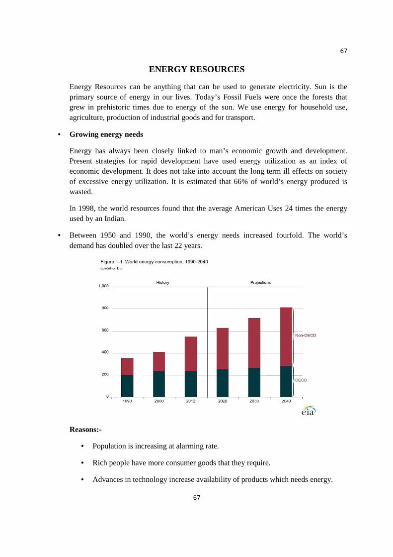
67
67
ENERGY RESOURCES
Energy Resources can be anything that can be used to generate electricity. Sun is the primary source of energy in our lives. Today’s Fossil Fuels were once the forests that grew in prehistoric times due to energy of the sun. We use energy for household use, agriculture, production of industrial goods and for transport.
• Growing energy needs
Energy has always been closely linked to man’s economic growth and development. Present strategies for rapid development have used energy utilization as an index of economic development. It does not take into account the long term ill effects on society of excessive energy utilization. It is estimated that 66% of world’s energy produced is wasted.
In 1998, the world resources found that the average American Uses 24 times the energy used by an Indian.
• Between 1950 and 1990, the world’s energy needs increased fourfold. The world’s demand has doubled over the last 22 years.
Reasons:-
• Population is increasing at alarming rate.
• Rich people have more consumer goods that they require.
• Advances in technology increase availability of products which needs energy.

68
68
• Wastage of energy
• Severe Weather
Solutions:
• Buy energy efficient products, e.g.; LED bulbs
• Decrease the CO2 emission to reduce global warming
• Use renewable energy resources
• Do not waste energy
Types of energy resources 1. Renewable energy resources 2. Non-renewable energy resources
RENEWABLE RESOURCES
• Renewable resources are sources which can be regenerated continuously in nature and are inexhaustible.
• Renewable energy systems use resources that are constantly replaced and are usually less polluting.
• They are also known as non-conventional sources of energy.
• However, several of the renewable sources, if not used sustainably can be depleted more quickly than they can be replenished.
• Example: Solar, wind, hydro, tidal, bioenergy, geothermal
I- SOLAR ENERGY
• The nuclear fission reactions occurring inside the sun release enormous amount of energy.
Applications of solar energy
Solar Cells
• They are made of wafers of semiconductor materials like Silicon and Gallium
• When solar radiations fall on them, a potential difference is produced which causes flow of electrons, thus producing electricity.
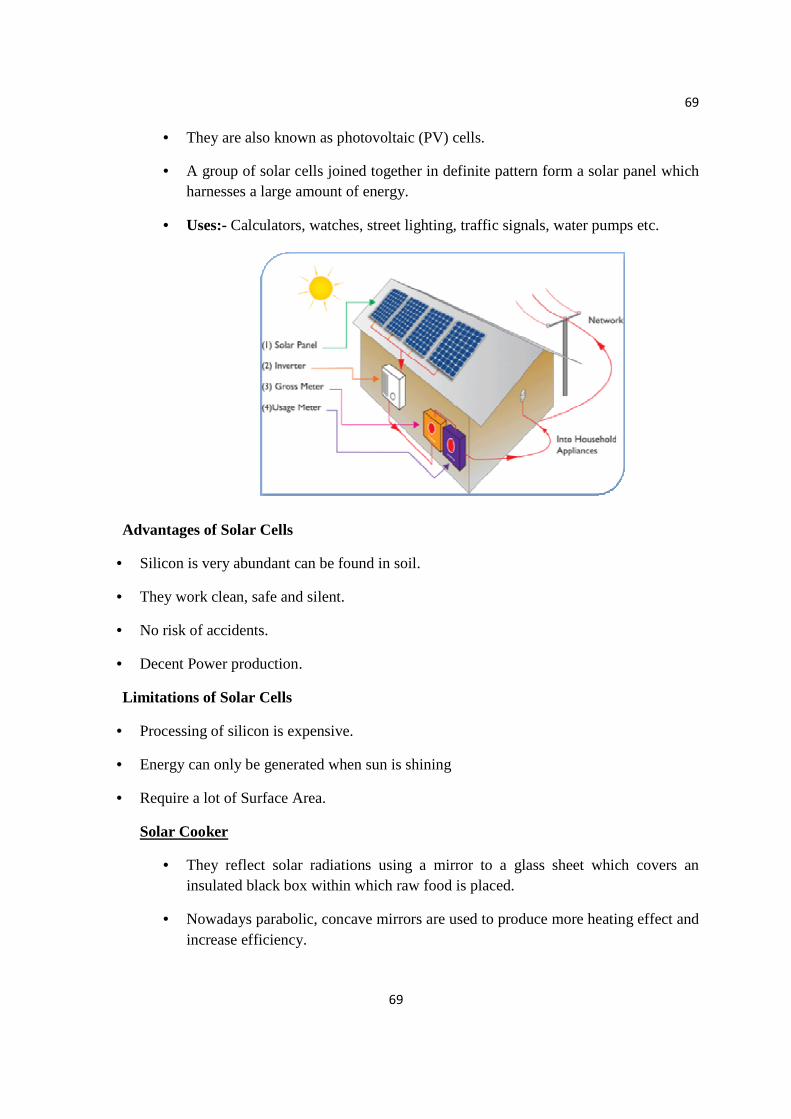
69
69
• They are also known as photovoltaic (PV) cells.
• A group of solar cells joined together in definite pattern form a solar panel which harnesses a large amount of energy.
• Uses:- Calculators, watches, street lighting, traffic signals, water pumps etc.
Advantages of Solar Cells
• Silicon is very abundant can be found in soil.
• They work clean, safe and silent.
• No risk of accidents.
• Decent Power production.
Limitations of Solar Cells
• Processing of silicon is expensive.
• Energy can only be generated when sun is shining
• Require a lot of Surface Area.
Solar Cooker
• They reflect solar radiations using a mirror to a glass sheet which covers an insulated black box within which raw food is placed.
• Nowadays parabolic, concave mirrors are used to produce more heating effect and increase efficiency.

70
70
Solar Water Heater
• It consists of two main parts:- the solar collector, and storage tank.
• The collector is a rectangular black box, with glass cover that faces the sun and is mounted on the roof.
• The box has a copper coil attached to it, carrying cold water. The water heats up due to solar energy. The hot water flows to storage tank, ready for use
Advantages of Solar Water Heater
• Clean and efficient
• Easy to maintain
• Quiet
• Takes up less space
Limitations of Solar Water Heater
• Expensive to install
• Does not work during night and on cloudy days
Solar Furnace
• A solar furnace is a structure that uses concentrated solar power to produce high temperatures usually for industries.
• Parabolic mirror or heliostats concentrate light onto focal point.
• The temperature at the focal point may reach 3500 degree C.
• This heat can be used to generate electricity, melt steel, and make hydrogen fuel or nanomaterials.
Solar Thermal Power Plant
• Solar energy is harnessed on a large scale by using concave reflectors which focus sunlight to boil water.
• The boiled water is used to rotate turbines which are in turn used to generate electricity.
• India’s largest solar thermal power plant is set up in Rajasthan and in known as India One Solar Thermal Power Plant.

71
71
Solar power potential of India
Solar power in India is a fast developing industry. The country's solar installed capacity reached 25.21 GW as of 31 December 2018. The target was 20 GW by the end of 2022. India’s solar power potential is estimated to be 750 GW.
II- HYDRO POWER This uses water flowing down a natural gradient to turn turbines to generate electricity known as ‘hydroelectric power’ by constructing dams across rivers. The water is stored and allowed to fall from a height. The blades of turbines are rotated by the force of the water. Historically, one of the first uses of hydro power was for mechanical milling, such as grinding grains
• It is of two types:
• Dams
• Run of River:- Small portion of river is diverted to turbine.
Uses:- It is used for flood control, irrigation and navigation
Advantages of Hydro Power
• Renewable Source
• Low operating and maintenance cost
• No pollution
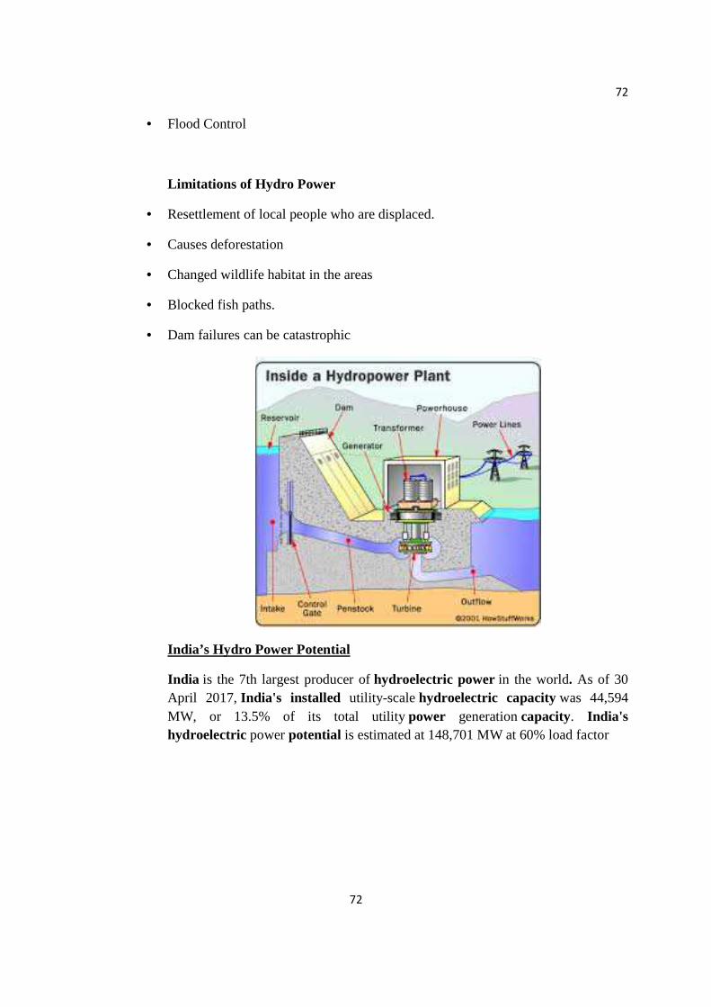
72
72
• Flood Control
Limitations of Hydro Power
• Resettlement of local people who are displaced.
• Causes deforestation
• Changed wildlife habitat in the areas
• Blocked fish paths.
• Dam failures can be catastrophic
India’s Hydro Power Potential
India is the 7th largest producer of hydroelectric power in the world. As of 30 April 2017, India's installed utility-scale hydroelectric capacity was 44,594 MW, or 13.5% of its total utility power generation capacity. India's hydroelectric power potential is estimated at 148,701 MW at 60% load factor
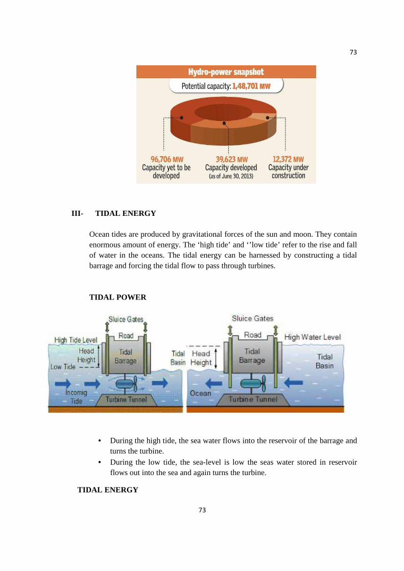
73
73
III- TIDAL ENERGY
Ocean tides are produced by gravitational forces of the sun and moon. They contain enormous amount of energy. The ‘high tide’ and ‘’low tide’ refer to the rise and fall of water in the oceans. The tidal energy can be harnessed by constructing a tidal barrage and forcing the tidal flow to pass through turbines. TIDAL POWER
• During the high tide, the sea water flows into the reservoir of the barrage and turns the turbine.
• During the low tide, the sea-level is low the seas water stored in reservoir flows out into the sea and again turns the turbine.
TIDAL ENERGY
74
74
According to the estimates of the Indian government, the country has a potential of 8,000 MW of tidal energy. In India, Gulf of Cambay, Gulf of Kutch and the Sunder ban deltas are tidal power sites.
Advantages of Tidal Energy
• Tidal power is an environmentally friendly energy source
• Water has 1000 times higher density than air, which makes it possible to generate electricity at low speeds.
• High efficiency
Limitations of Tidal Energy
• Expensive to build
• Very location specific
• Storage backup required
• Impact on fish, marine, mammals and birds.
• Decreases salinity.
IV- WAVE ENERGY
By warming the water, the sun creates ocean currents and winds that produce waves. It is a type of alternate energy source Wave power converts the motion of waves into electrical energy. For this an energy extraction device is placed on the surface of the oceans that captures the energy produced by the wave movement and converts this mechanical energy into electrical power. OCEAN THERMAL ENERGY (OTEC) Oceans and at deeper levels is called Ocean thermal energy. These plants are called as Ocean thermal energy conversion (OTEC). A difference of 20 °C or more is required between surface water and deeper water of ocean. The warm surface water of ocean is used to boil a liquid like ammonia. The high pressure vapours of the liquid formed by boiling are then used to turn the turbine of a generator and produce electricity. The colder water from the deeper oceans is pumped to cool and condense the vapours into liquid.
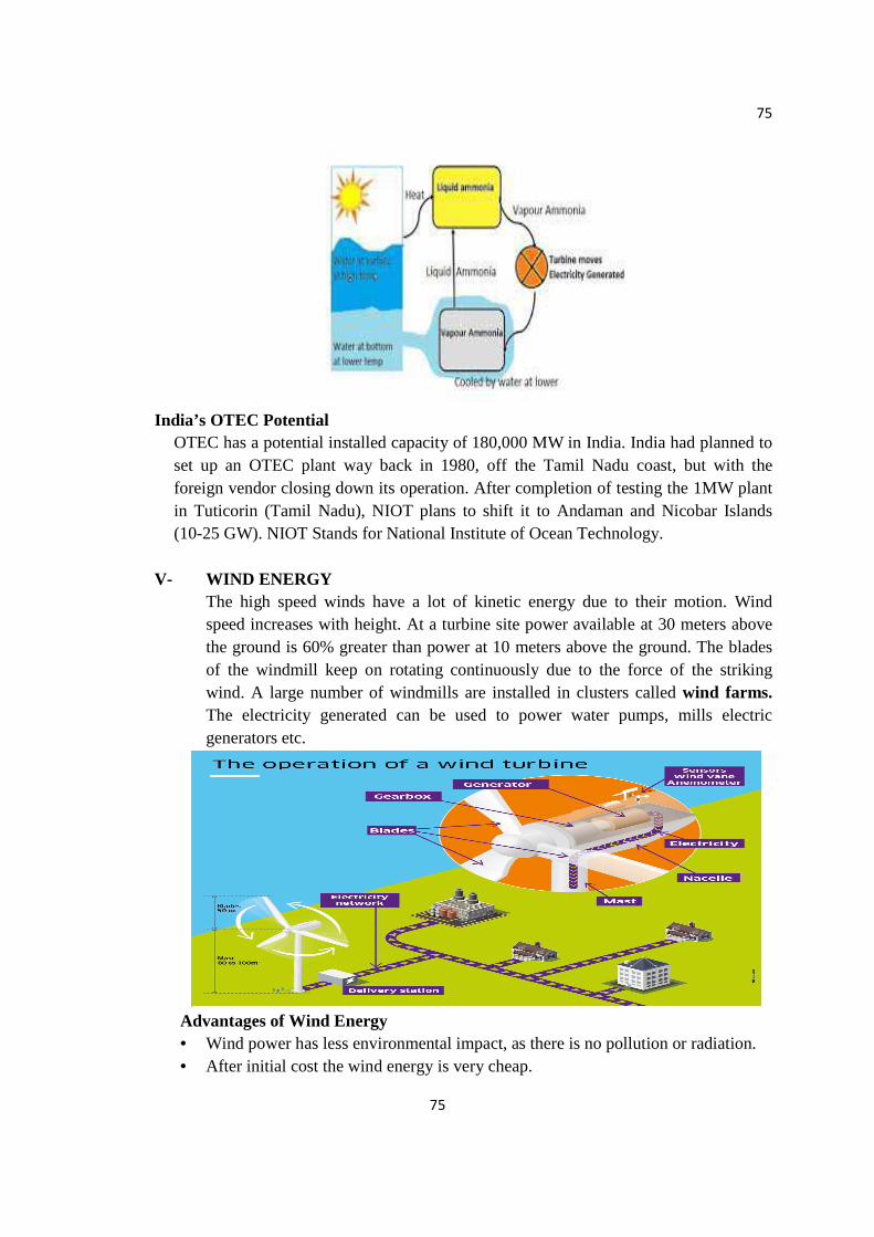
75
75
India’s OTEC Potential
OTEC has a potential installed capacity of 180,000 MW in India. India had planned to set up an OTEC plant way back in 1980, off the Tamil Nadu coast, but with the foreign vendor closing down its operation. After completion of testing the 1MW plant in Tuticorin (Tamil Nadu), NIOT plans to shift it to Andaman and Nicobar Islands (10-25 GW). NIOT Stands for National Institute of Ocean Technology.
V- WIND ENERGY
The high speed winds have a lot of kinetic energy due to their motion. Wind speed increases with height. At a turbine site power available at 30 meters above the ground is 60% greater than power at 10 meters above the ground. The blades of the windmill keep on rotating continuously due to the force of the striking wind. A large number of windmills are installed in clusters called wind farms. The electricity generated can be used to power water pumps, mills electric generators etc.
Advantages of Wind Energy • Wind power has less environmental impact, as there is no pollution or radiation. • After initial cost the wind energy is very cheap.
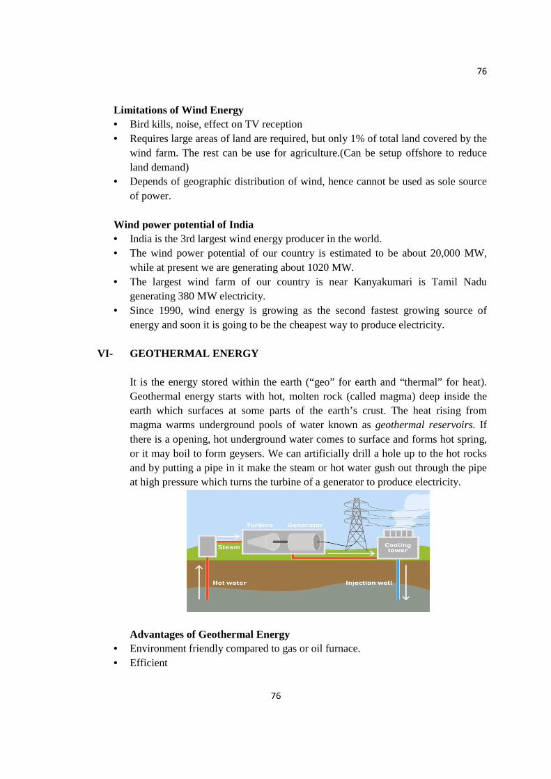
76
76
Limitations of Wind Energy • Bird kills, noise, effect on TV reception • Requires large areas of land are required, but only 1% of total land covered by the
wind farm. The rest can be use for agriculture.(Can be setup offshore to reduce land demand)
• Depends of geographic distribution of wind, hence cannot be used as sole source of power.
Wind power potential of India • India is the 3rd largest wind energy producer in the world. • The wind power potential of our country is estimated to be about 20,000 MW,
while at present we are generating about 1020 MW. • The largest wind farm of our country is near Kanyakumari is Tamil Nadu
generating 380 MW electricity. • Since 1990, wind energy is growing as the second fastest growing source of
energy and soon it is going to be the cheapest way to produce electricity.
VI- GEOTHERMAL ENERGY
It is the energy stored within the earth (“geo” for earth and “thermal” for heat). Geothermal energy starts with hot, molten rock (called magma) deep inside the earth which surfaces at some parts of the earth’s crust. The heat rising from magma warms underground pools of water known as geothermal reservoirs. If there is a opening, hot underground water comes to surface and forms hot spring, or it may boil to form geysers. We can artificially drill a hole up to the hot rocks and by putting a pipe in it make the steam or hot water gush out through the pipe at high pressure which turns the turbine of a generator to produce electricity.
Advantages of Geothermal Energy • Environment friendly compared to gas or oil furnace. • Efficient

77
77
• Not weather dependent • Quieter operation • Long lifespan
Limitations of Geothermal Energy
• High costs. • Water from geothermal reservoir often contains minerals that are corrosive and
polluting • Are location centric
India’s Potential India has about 10,000 MW of geothermal power potential that can be harnessed for various purposes.
• While currently India is using about 203 MW of its thermal energy. • Puga Valley (J&K) • Tatapani (Chhattisgarh) • Godavari Basin Manikaran (Himachal Pradesh)
Bakreshwar (West Bengal)
VII- BIOMASS ENERGY Biomass is organic matter which acts as renewable source of energy produced by the plants or animals which includes wood, crop residue, cattle dung, manure, sewage, etc.
BIOMASS ENERGY types 1. Energy Plantations
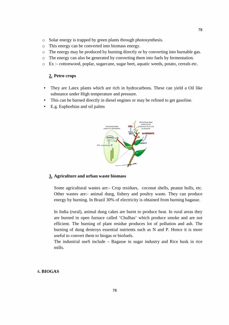
78
78
o Solar energy is trapped by green plants through photosynthesis. o This energy can be converted into biomass energy. o The energy may be produced by burning directly or by converting into burnable gas. o The energy can also be generated by converting them into fuels by fermentation. o Ex :- cottonwood, poplar, sugarcane, sugar beet, aquatic weeds, potato, cereals etc.
2. Petro crops
• They are Latex plants which are rich in hydrocarbons. These can yield a Oil like
substance under High temperature and pressure. • This can be burned directly in diesel engines or may be refined to get gasoline.
• E.g. Euphorbias and oil palms
3. Agriculture and urban waste biomass
Some agricultural wastes are:- Crop residues, coconut shells, peanut hulls, etc. Other wastes are:- animal dung, fishery and poultry waste. They can produce energy by burning. In Brazil 30% of electricity is obtained from burning bagasse. In India (rural), animal dung cakes are burnt to produce heat. In rural areas they are burned in open furnace called ‘Chulhas’ which produce smoke and are not efficient. The burning of plant residue produces lot of pollution and ash. The burning of dung destroys essential nutrients such as N and P. Hence it is more useful to convert them to biogas or biofuels. The industrial useS include – Bagasse in sugar industry and Rice husk in rice mills.
4. BIOGAS
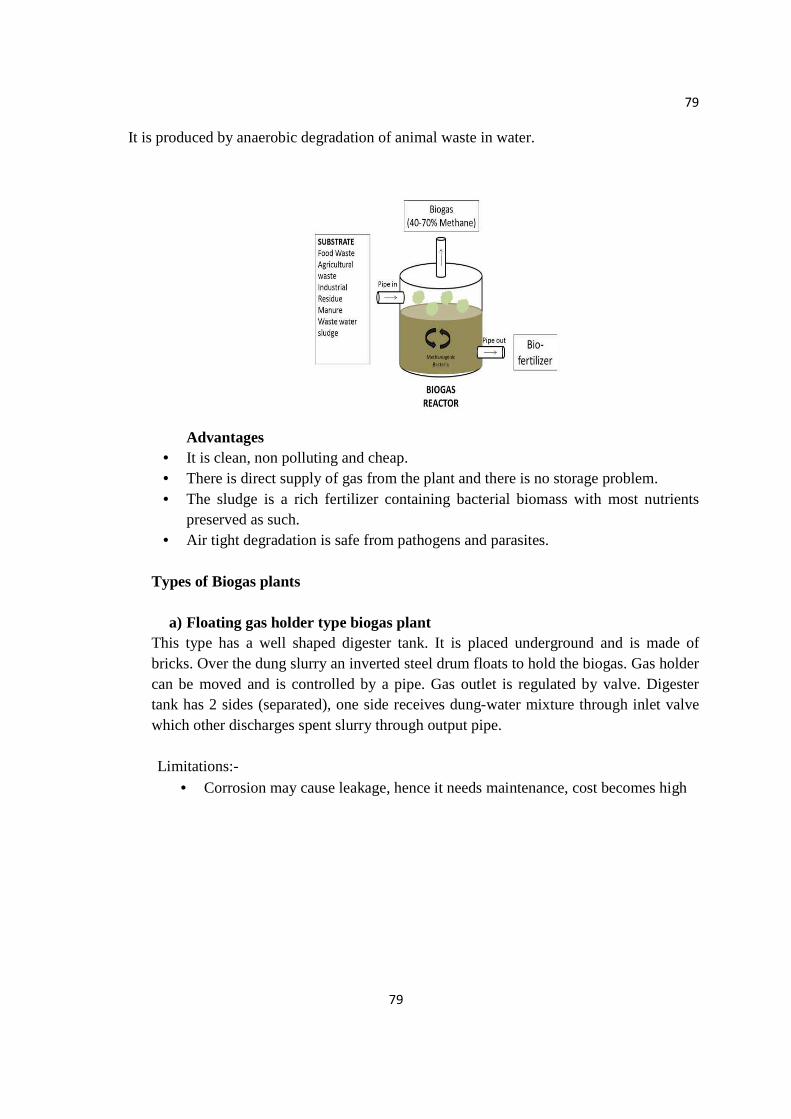
79
79
It is produced by anaerobic degradation of animal waste in water.
Advantages
• It is clean, non polluting and cheap. • There is direct supply of gas from the plant and there is no storage problem. • The sludge is a rich fertilizer containing bacterial biomass with most nutrients
preserved as such. • Air tight degradation is safe from pathogens and parasites.
Types of Biogas plants
a) Floating gas holder type biogas plant
This type has a well shaped digester tank. It is placed underground and is made of bricks. Over the dung slurry an inverted steel drum floats to hold the biogas. Gas holder can be moved and is controlled by a pipe. Gas outlet is regulated by valve. Digester tank has 2 sides (separated), one side receives dung-water mixture through inlet valve which other discharges spent slurry through output pipe.
Limitations:-
• Corrosion may cause leakage, hence it needs maintenance, cost becomes high
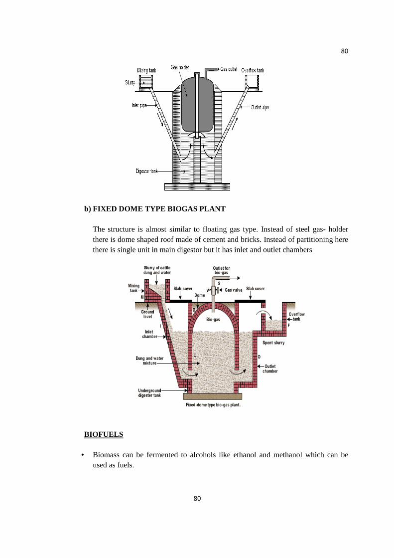
80
80
b) FIXED DOME TYPE BIOGAS PLANT
The structure is almost similar to floating gas type. Instead of steel gas- holder there is dome shaped roof made of cement and bricks. Instead of partitioning here there is single unit in main digestor but it has inlet and outlet chambers
BIOFUELS
• Biomass can be fermented to alcohols like ethanol and methanol which can be
used as fuels.
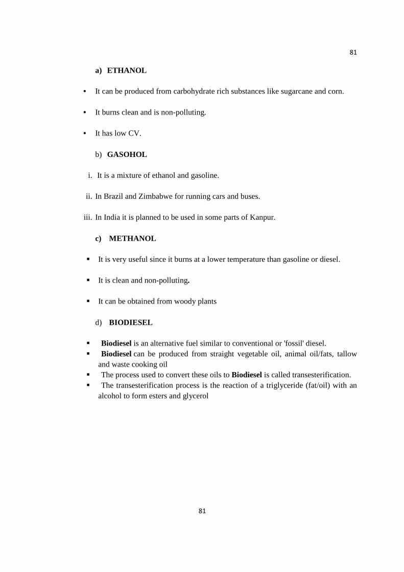
81
81
a) ETHANOL
• It can be produced from carbohydrate rich substances like sugarcane and corn.
• It burns clean and is non-polluting.
• It has low CV.
b) GASOHOL
i. It is a mixture of ethanol and gasoline.
ii. In Brazil and Zimbabwe for running cars and buses.
iii. In India it is planned to be used in some parts of Kanpur.
c) METHANOL
It is very useful since it burns at a lower temperature than gasoline or diesel.
It is clean and non-polluting.
It can be obtained from woody plants
d) BIODIESEL
Biodiesel is an alternative fuel similar to conventional or 'fossil' diesel. Biodiesel can be produced from straight vegetable oil, animal oil/fats, tallow
and waste cooking oil The process used to convert these oils to Biodiesel is called transesterification. The transesterification process is the reaction of a triglyceride (fat/oil) with an
alcohol to form esters and glycerol
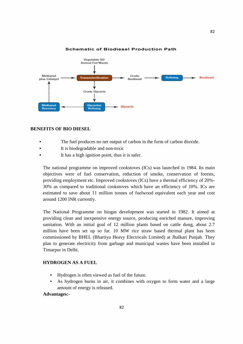
82
82
BENEFITS OF BIO DIESEL
• The fuel produces no net output of carbon in the form of carbon dioxide.
• It is biodegradable and non-toxic
• It has a high ignition point, thus it is safer.
The national programme on improved cookstoves (ICs) was launched in 1984. Its main objectives were of fuel conservation, reduction of smoke, conservation of forests, providing employment etc. Improved cookstoves (ICs) have a thermal efficiency of 20%-30% as compared to traditional cookstoves which have an efficiency of 10%. ICs are estimated to save about 11 million tonnes of fuelwood equivalent each year and cost around 1200 INR currently. The National Programme on biogas development was started in 1982. It aimed at providing clean and inexpensive energy source, producing enriched manure, improving sanitation. With an initial goal of 12 million plants based on cattle dung, about 2.7 million have been set up so far. 10 MW rice straw based thermal plant has been commissioned by BHEL (Bhartiya Heavy Electricals Limited) at Jhalkari Punjab. They plan to generate electricity from garbage and municipal wastes have been installed in Timarpur in Delhi. HYDROGEN AS A FUEL
• Hydrogen is often viewed as fuel of the future. • As hydrogen burns in air, it combines with oxygen to form water and a large
amount of energy is released. Advantages:-

83
83
• It has high CV and hence acts as excellent fuel. • It is non-polluting. • It can be produced by:-
• Thermal dissociation of water at 3273 K or above • Chemical reaction of water with other chemicals in 2-3 cycles. This
eliminates the need of high temperature. • Electrolytic dissociation of water • Photolysis of water (breakdown of water in presence of sunlight)
Presently hydrogen is used in the form of liquid hydrogen as fuel in spaceships. Hydrogen can be used as fuel cell to generate electricity; here hydrogen is burnt in air in presence of electrolyte to produce electricity NON-RENEWABLE RESOURCES
• Non renewable resources have accumulated in nature over a long span of time and cannot be replenished when exhausted.
• These consist of the mineral based hydrocarbon fuels coal, oil and natural gas, that were formed from prehistoric times.
• They are burnt to boil water, which produces steam and turns the turbines to generate power.
• They will not last long, their conservation is thus necessary.
Disadvantages of Non Renewable Resources
• Polluting:- When they are burned harmful substances like nitrous oxides, carbon dioxide(green house gas), oxides of sulphur. This has lead to lung problems and acid rain which in turn damage the marble structures.
• Can’t be replenished. • Will deplete soon.
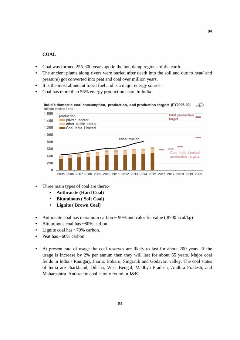
84
84
COAL
• Coal was formed 255-300 years ago in the hot, damp regions of the earth. • The ancient plants along rivers were buried after death into the soil and due to heat( and
pressure) got converted into peat and coal over million years. • It is the most abundant fossil fuel and is a major energy source. • Coal has more than 56% energy production share in India.
• Three main types of coal are there:- • Anthracite (Hard Coal) • Bituminous ( Soft Coal) • Lignite ( Brown Coal)
• Anthracite coal has maximum carbon ~ 90% and calorific value ( 8700 kcal/kg) • Bituminous coal has ~80% carbon. • Lignite coal has ~70% carbon. • Peat has ~60% carbon.
• At present rate of usage the coal reserves are likely to last for about 200 years. If the
usage is increase by 2% per annum then they will last for about 65 years. Major coal fields in India:- Ranigarj, Jharia, Bokaro, Singrauli and Godavari valley. The coal states of India are Jharkhand, Odisha, West Bengal, Madhya Pradesh, Andhra Pradesh, and Maharashtra. Anthracite coal is only found in J&K.
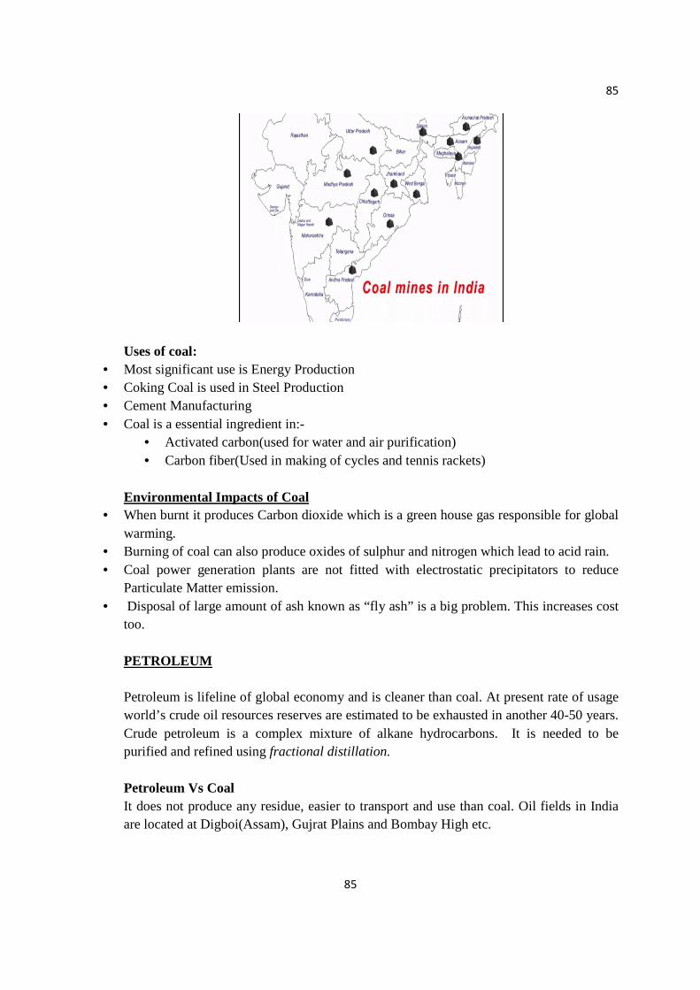
85
85
Uses of coal:
• Most significant use is Energy Production • Coking Coal is used in Steel Production • Cement Manufacturing • Coal is a essential ingredient in:-
• Activated carbon(used for water and air purification) • Carbon fiber(Used in making of cycles and tennis rackets)
Environmental Impacts of Coal
• When burnt it produces Carbon dioxide which is a green house gas responsible for global warming.
• Burning of coal can also produce oxides of sulphur and nitrogen which lead to acid rain. • Coal power generation plants are not fitted with electrostatic precipitators to reduce
Particulate Matter emission. • Disposal of large amount of ash known as “fly ash” is a big problem. This increases cost
too. PETROLEUM Petroleum is lifeline of global economy and is cleaner than coal. At present rate of usage world’s crude oil resources reserves are estimated to be exhausted in another 40-50 years. Crude petroleum is a complex mixture of alkane hydrocarbons. It is needed to be purified and refined using fractional distillation. Petroleum Vs Coal It does not produce any residue, easier to transport and use than coal. Oil fields in India are located at Digboi(Assam), Gujrat Plains and Bombay High etc.
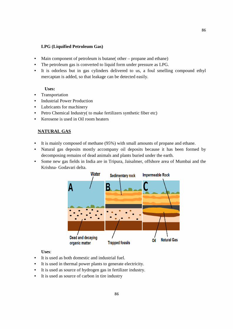
86
86
LPG (Liquified Petroleum Gas)
• Main component of petroleum is butane( other – propane and ethane) • The petroleum gas is converted to liquid form under pressure as LPG. • It is odorless but in gas cylinders delivered to us, a foul smelling compound ethyl
mercaptan is added, so that leakage can be detected easily.
Uses: • Transportation • Industrial Power Production • Lubricants for machinery • Petro Chemical Industry( to make fertilizers synthetic fiber etc) • Kerosene is used in Oil room heaters
NATURAL GAS
• It is mainly composed of methane (95%) with small amounts of propane and ethane. • Natural gas deposits mostly accompany oil deposits because it has been formed by
decomposing remains of dead animals and plants buried under the earth. • Some new gas fields in India are in Tripura, Jaisalmer, offshore area of Mumbai and the
Krishna- Godavari delta.
Uses:
• It is used as both domestic and industrial fuel. • It is used in thermal power plants to generate electricity. • It is used as source of hydrogen gas in fertilizer industry. • It is used as source of carbon in tire industry
87
87
Natural gas Vs Other Sources
• It is the cleanest fossil fuel. • It can be easily transported through pipelines. • It has a high CV and burns without smoke.
CNG (Compressed Natural Gas)
• It is used as an alternative to petrol and diesel for transport of vehicles. • It is being used extensively in Delhi. • It has greatly reduced vehicular pollution in the city
SNG (Synthetic Natural Gas)
• Synthetic natural gas is a type of gas created from coal that serves as a substitute for natural gas and is suitable for transmission in natural gas pipelines.
• It is a mixture of carbon monoxide and hydrogen. • It is desirable where there is an absence or shortage of natural gas in a region. • It has properties similar to natural gas • It is produced by gasification of coal followed by catalytic conversion to methane
Environmental Impacts of Oil based resources
• Possibility of leaks and fires can cause devastating damage. • Oil wastes such as grease are produced which can clog pipelines and tankers. • Oil powered vehicles emit harmful gases which is the major cause of air pollution
especially in cities with heavy traffic density. • Dependence on dwindling fossil fuels have caused political tension and conflicts. Most of
the world’s reserves are located in Middle East India’s Potential
• Together they account for around 10% of India’s Energy Production • As on 23 October 2015, the installed capacity of gas-based power plants in India was
25,057.13
• Nuclear Energy is known for its high destructive power as evidenced from nuclear weapons.
• The nuclear energy can be harnessed to generate electricity. • Nuclear energy can be generated by two types of reactions

88
88
NUCLEAR FISSION It is the nuclear change in which nucleus of certain isotopes with large mass numbers are split into lighter nuclei on bombardment by neutrons. A very large amount of energy is released.
• Nuclear Reactors make use of nuclear chain reaction. • They use Uranium 235 to produce electricity. • Energy released from 1kg of Uranium 235 is equivalent to burning 3000 tons of coal.
NUCLEAR FUSION
• The two isotopes of a light element are forced together at extremely high temperature (1 billion K) until they can fuse to form a heavier nucleus releasing enormous amount of energy
• It is a challenge to initiate the process because such high temperatures are not easily achievable.
• If achieved it is regarded as almost inexhaustible source of energy.
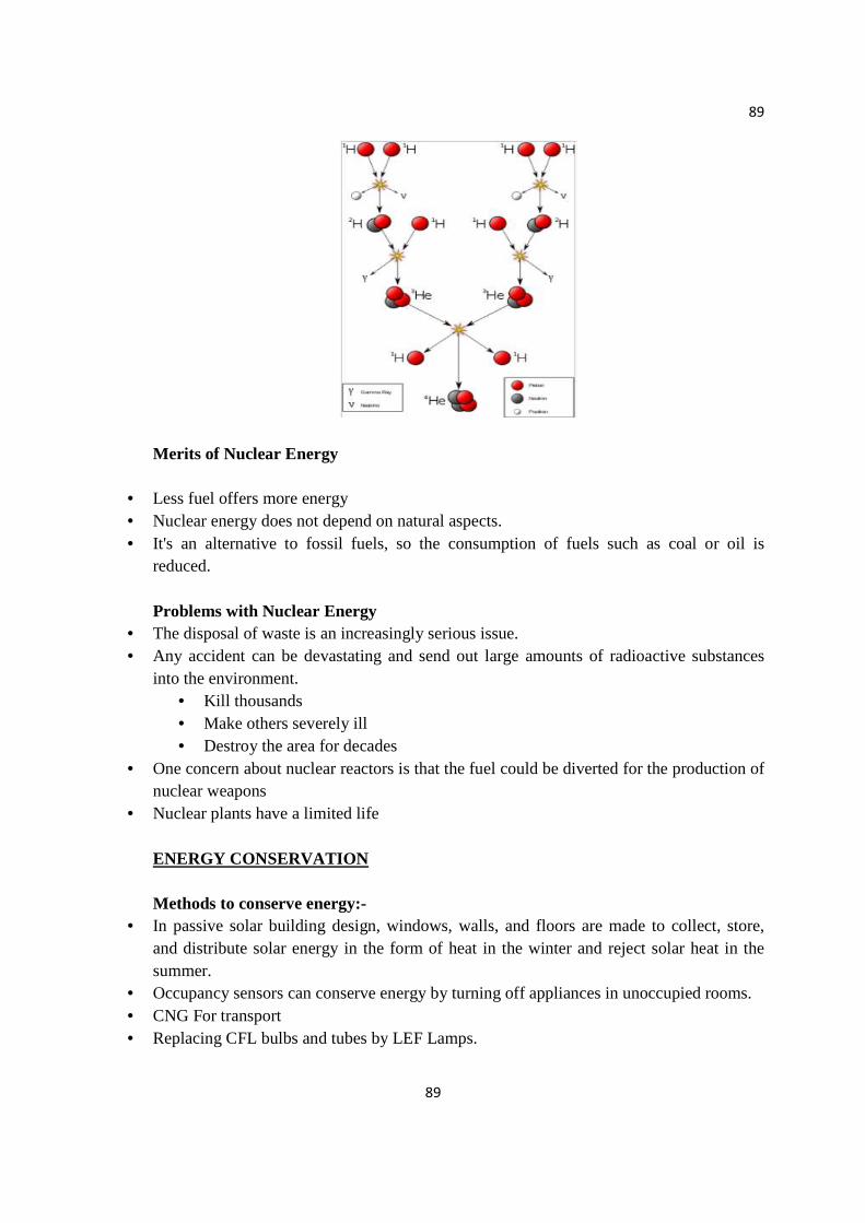
89
89
Merits of Nuclear Energy
• Less fuel offers more energy • Nuclear energy does not depend on natural aspects. • It's an alternative to fossil fuels, so the consumption of fuels such as coal or oil is
reduced. Problems with Nuclear Energy
• The disposal of waste is an increasingly serious issue. • Any accident can be devastating and send out large amounts of radioactive substances
into the environment. • Kill thousands • Make others severely ill • Destroy the area for decades
• One concern about nuclear reactors is that the fuel could be diverted for the production of nuclear weapons
• Nuclear plants have a limited life ENERGY CONSERVATION Methods to conserve energy:-
• In passive solar building design, windows, walls, and floors are made to collect, store, and distribute solar energy in the form of heat in the winter and reject solar heat in the summer.
• Occupancy sensors can conserve energy by turning off appliances in unoccupied rooms. • CNG For transport • Replacing CFL bulbs and tubes by LEF Lamps.

90
90
• Energy efficient cooking ’chulas’ help the movement of air through it so that wood is burnt more efficiently.
• Biomass can be converted into Biogas and Biofuels. • The material left after the use of biogas and biofuel can be used as fertilizer.
Some methods to conserve energy in daily life:-
1. Use natural light during the day. 2. You can just walk down to your destination if it is close enough 3. Use solar heater at home 4. Turn off your lights even if you are not using them, even for few minutes. 5. Turn off your TV, radio when not in Use 6. Iron all your clothes at same time, Do the same with washing machine. 7. Keep the air conditioner at 24-26 C and set a off timer. 8. Use public transports 9. Set your washing machine to a cold wash. 10. Install light bulbs on work table and use them instead of illuminating the whole room
Note: Case studies for self-learning (to be done by the students)

91
91
REFERENCES
1. E. Barucha, Textbook of Environmental Studies for Undergraduate Courses,
Universities Press (India) Pvt. Ltd., 2005.
2. S. Chawla, A Textbook of Environmental Studies, McGraw Hill Education Private
Limited, 2012
3. G. T. Miller, Environmental Science, Thomas Learning, 2012
4. R. Rajagopalan, Environmental Studies: From Crisis to Cure, 2nd Edition, Oxford
University Press, 2011.
5. A.K. De, Environmental Chemistry, New Age Int. Publ. 2012.
6. A. Kaushik and C.P. Kaushik, Perspectives in Environment Studies, 4th Edition, New
Age International Publishers, 2013.